Article

Salt Constructs in Paleo-Lake Basins as High-Priority Astrobiology Targets

by
Michael S. Phillips
1,*,
Michael McInenly
2,
Michael H. Hofmann
2,
Nancy W. Hinman
2,
Kimberley Warren-Rhodes
3,4,
Edgard G. Rivera-Valentín
1 and
Nathalie A. Cabrol
3
1
The Johns Hopkins University Applied Physics Laboratory, Laurel, MD 20723, USA
2
Department of Geosciences, University of Montana, Missoula, MT 59812, USA
3
SETI Institute Carl Sagan Center, Mountain View, CA 94043, USA
4
NASA Ames, Space Science Division, Moffett Field, CA 94035, USA
*
Author to whom correspondence should be addressed.
Remote Sens. 2023, 15(2), 314; https://doi.org/10.3390/rs15020314
Submission received: 18 November 2022 / Revised: 21 December 2022 / Accepted: 3 January 2023 / Published: 5 January 2023
(This article belongs to the Special Issue Planetary Landscapes Analysis Based on Remote Sensing Images)

Abstract

:
In extreme environments, microbial organisms reside in pockets with locally habitable conditions. Micro-climates conducive to the persistence of life in an otherwise inhospitable environment—“refugia”—are spatially restricted and can be micro- to centimeters in extent. If martian microbes are preserved in fossil refugia, this presents a double-edged sword for biosignature exploration: these locations will be specific and targetable but small and difficult to find. To better understand what types of features could be refugia in martian salt-encrusted basins, we explore a case study of two terrestrial habitats in salt-encrusted paleo-lake basins (salars): Salar Grande (SG) in the Atacama Desert and Salar de Pajonales (SdP) in the Altiplano Puna plateau of Chile. We review the formation of salt constructs within SG and SdP, which are the features that serve as refugia in those salars, and we explore the connection between the formation of salt constructs at the local scale with the larger-scale geologic phenomena that enable their formation. Our evaluation of terrestrial salars informs an assessment of which chloride basins on Mars might have had a high potential to form life-hosting salt constructs and may preserve biosignatures, or even host extant life. Our survey of martian salars identifies 102 salars in regions with a geographic context conducive to the formation of salt constructs, of which 17 have HiRISE coverage. We investigate these 17 martian salars with HiRISE coverage and locate the presence of possible salt constructs in 16 of them. Salt constructs are features that have may have been continuously habitable for the past ~3.8 Byr, have exceptional preservation potential, and are accessible by robotic exploration. Future work could explore in detail the mechanisms involved in the formation of the topographic features we identified in salt-encrusted basins on Mars to test the hypothesis that they are salt constructs.

Graphical Abstract

1. Introduction

After multiple decades of robotic exploration on the martian surface, there has been no conclusive evidence for past or present life on Mars. Many types of habitable environments existed on Mars, including subaqueous deltas and lakes [1,2,3,4,5,6], subaerial environments [7], salt-rich environments [8,9], lithic substrates [10], subsurface caves and aquifers [11,12,13], and iron-rich environments [14]. Deltas within paleo-lake basins have, in part, been a priority for exploration because these depositional environments collect and preserve material from across their catchment. Deltas, therefore, act as focusing mechanisms for a larger area; this effectively reduces the search space for signs of past life to a more specific region feasibly explored by robotic missions. The taphonomic history of organic compounds preserved in a delta can be complex because they would have been subjected to alteration during weathering, erosion, transportation, preservation, and diagenesis. Laboratory analyses of these organics in samples returned to Earth will be the most conclusive, and perhaps only, way to determine their biogenicity, e.g., [15,16]. Deltas, while effectively reducing the search space as indicated above, are nevertheless areally extensive features, and it is still not clear where, on or in a delta, is the best place to sample to yield the most conclusive evidence for past life. Are there environments that have a high potential to both host and preserve microbial organisms in situ, and that are specific targets, possibly identifiable from orbit, to which a rover could be driven, c.f., [17]? Here, we suggest that martian salt-encrusted paleo-lake basins that contain features constructed from salt may be environments that uniquely and affirmatively answer this question.

1.1. Why Salt Environments?

On Earth, as an environment trends toward sterility, life retreats to smaller and smaller patches where conditions remain locally habitable. These last remaining outposts for life have been dubbed “refugia” [18,19]. A subset of martian habitable environments can be classified as refugia, including caves and subsurface environments [10]—because they sustain a micro-climate distinct from surface conditions—and salt-rich environments, e.g., [8]—because they are hygroscopic and sustain elevated water activity compared to their surroundings. As one of the last remaining locations where organisms can survive, the environmental conditions that created salt-rich refugia act as a natural winnowing mechanism to reduce the search space for biosignatures. Refugia will also be the longest sustained habitats on the planet, having been habitable when the martian surface sustained liquid water until, arguably, the present day [19,20,21].
Noachian to Hesperian salt-encrusted environments have been preserved across the martian surface, likely due to protection by capping units and a lack of post-depositional surficial liquid water that would erase evidence of their existence, e.g., [22]. In the case of salt-encrusted basins, the refugia can also preserve signs of life exceptionally well [23,24,25]. In addition to exceptional preservation potential, organic matter can be preserved in situ—meaning organisms could have lived, died, and been preserved in the same position. This simplified taphonomic history can facilitate the interpretation and verification of organic matter as biogenic by, for example, preserving with higher fidelity their original complex forms, e.g., [25]. Salt habitats are also accessible on the surface, or near subsurface, by robotic exploration, and technologies exist today that could be used to characterize salt chemistry [26] and detect biosignatures [27] in situ. The argument that salt environments are an appealing astrobiology target is not new, e.g., [9,19,20,28]; however, we suggest that salt constructs within salt environments are specific, targetable features that were particularly likely to have served as refugia, and, therefore, deserve focused attention.

1.2. Geologic Context

SG and SdP are two Chilean salars known for their suitability as Mars analog environments [17,29,30,31,32,33]. SG lies in the western Atacama Desert and SdP sits at the edge of the Atacama and the Altiplano Puna plateau of Chile (Figure 1). The Chilean Atacama is west of the Cordillera de Domeyko, between latitudes 28° S and 18° S, and has experienced hyper-arid conditions for the past 15 million years, and potentially much longer [34,35]. As the region dried, many basins that once held lakes became salt-encrusted playas [36,37]. The Altiplano is arid, though not quite as dry as the Atacama, and experiences some of the highest levels of UV irradiation on Earth [38]. The Neogene salars of the Atacama and Altiplano are perhaps the best analogs on Earth for the Noachian/Hesperian salt-encrusted paleo-lakes of Mars [22,29,32,39,40,41,42].

1.3. Salt Construct Formation

For the purposes of this article, we define salt constructs as positive topographic features made of salt minerals. Note that we are not referring to “surface salt structures”, which are tectonic features that form due to deformation of salt under heat and pressure see, e.g., [43]. Additionally, we include in our definition of “salt” all minerals that are ionic compounds composed of a metal cation and non-metal anion, e.g., halides, sulfates, nitrates, borates, carbonates, etc.

1.3.1. Halite Nodules at Salar Grande

“Halite nodules” are an example of salt constructs at SG—a fossil salar in the western Atacama Desert (Figure 2). They are small bulbous forms composed of halite that form around central polygons [30,44]. Halite nodules are on the order of tens of centimeters in length and in height, and they commonly cluster in groups. The formation process we describe below for halite nodules is after that documented by Artieda et al. [44]. The nodules form in “fossil” salars, meaning that the salars no longer experience seasonal inundation by surface water and are cut off from subsurface water sources [44]. Halite, a deliquescent salt, absorbs and liquifies atmospheric water vapor that rolls in each morning from the sea, known as the camanchaca fog. During the day, the deliquesced water evaporates and deposits a fresh rind of halite on the exterior of nascent nodules at the rims of polygons. This becomes a run-away effect because, as nodules grow and become focal points of evaporation, salt-laden vapor is transported preferentially along this gradient, and the nodules grow larger and faster than their surroundings. Although atmospheric water is the source for deliquescence at SG, there is no obvious reason that a different mechanism, such as ground water transported through fractures, could not also perform the same function to provide water to the core of halite nodules.

1.3.2. Gypsum Domes and Ridges at Salar de Pajonales

SdP resides on the border between the Atacama and the Altiplano plateau at the foothills of the Andes. Gypsum domes and ridges at SdP are domical structures and networks of ridges, often comprising the edges of 10 to 100-m-scale polygons, composed of gypsum (Figure 3). There are many ideas for how such features form that can broadly be categorized as biotic and abiotic [45]. Biotic domes, i.e., stromatolites, form when microbial mats enhance crystallization of gypsum by providing a nucleation site for crystal growth, and successive mineral and microbial growth leads to dome formation over time [45,46,47]. Stromatolites typically remain domical, but commonly coalesce to resemble ridges or other composite features [48]. Many mechanisms exist for abiotic dome and ridge growth, but all involve volume change due to either crystallization of new minerals or phase changes between hydrated and dehydrated states [45], e.g., [49]. An abiotic formation of gypsum domes and ridges does not mean these features are uninhabited (Figure 3E), e.g., [50]. Gypsum domes and ridges at SdP were shown to be preferentially inhabited by photosynthetic communities likely due to their increased ability to capture and retain liquid water [17].
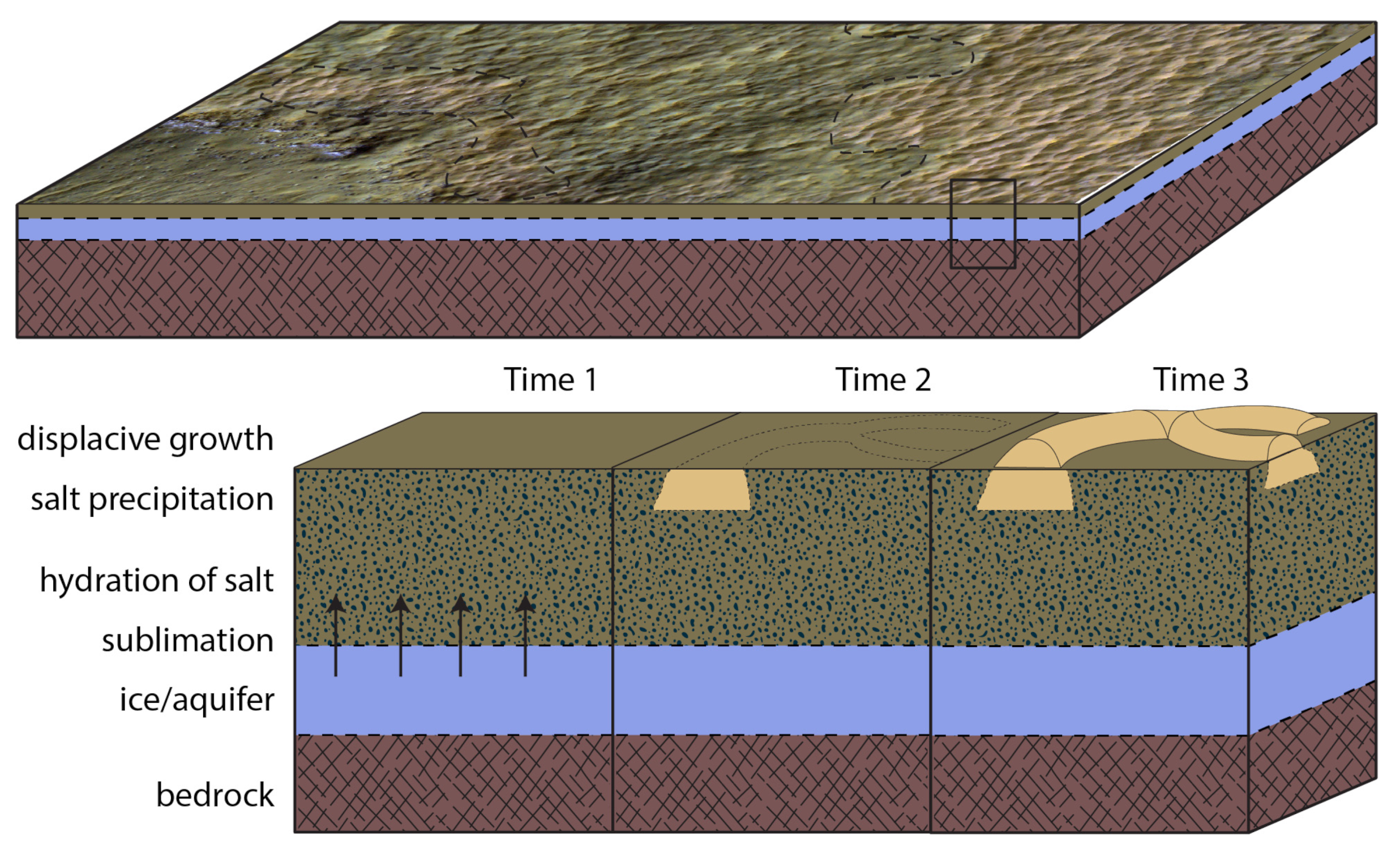
A recent model for the SdP domes and ridges explains their formation through the action of upwardly mobile water vapor sourced from beneath the salar (Figure 3, [33]). A flat selenite gypsum crust originally formed through subaqueous precipitation at a time when the basin contained water. This originally flat crust was observed in a channel that cross-cuts the gypsum field along its eastern boundary. Dehydration of the crust over time caused a general decrease in volume of the salt crust as well as a transition from gypsum to anhydrite for parts of the crust. The decrease in the salt crust volume formed near-surface fracture networks in the crust that are point-like, lineate, and polygonal. Water preferentially escapes through these zones of weakness, enabling phase changes from anhydrite to gypsum as well as crystallization of new gypsum; the subsequent volume increase is accommodated at the surface, or in near-surface vadose-phreatic zone interface, by the formation of domes and ridges. A similar model was proposed by Szynkiewicz et al. [51] for gypsum domes at White Sands, which resemble some of the larger domes at SdP.

2. Materials and Methods

We use data from satellites, small unmanned aerial systems (sUASs), and field-based measurements to explore the geologic context of SG and SdP and illuminate the regional-scale geologic forces that make possible the local-scale formation of salt constructs within these basins. New insights into the regional-scale geologic forces that drive salt construct formation in terrestrial Mars analog salars are used to guide a search for salt constructs in martian salt-encrusted basins (hereafter, salars). Finally, we analyze images from the High-Resolution Imaging Science Experiment (HiRISE) [52] of select martian salars and propose locations of possible salt constructs on Mars.

2.1. Terrestrial Datasets

2.1.1. Orbital

We used a series of open-source algorithms provided by the Alaska Satellite Facility (ASF) to find, download, and process Synthetic Aperture Radar (SAR) images collected by various sensors. Ninety-two co- and cross-polarized images from 2018 through 2021, collected by the Sentinel-1 sensor at intervals ranging from 6–28 days, were radiometrically terrain corrected (RTC) using GAMMA software [53]. Final processing occurred on the OpenSARlab hosted by Amazon Web Services and ASF [54]. The OpenSARlab hosts a series of interdependent Python science packages, allowing the user to analyze a spatially and temporally dense set of images.
The digital elevation models in Figure 4 are composites of an Advanced Spaceborne Thermal Emission and Reflection Radiometer (ASTER) Global Digital Elevation Model (GDEM) Color Index layer (background), and a Shuttle Radar Topography Mission (NASA SRTM v3, Color Index) layer in the foreground. Both datasets provide spatial resolution at 30 m and are available at https://worldview.earthdata.nasa.gov (accessed on 14 September 2022). The NASA SRTM v3 elevation data digital elevation model (DEM) was generated by using radar interferometry. For the purpose of highlighting the topography of the region, the SRTM dataset was truncated at 630 m above sea level (ASL) at its low elevation and 750 m ASL as its high elevation. The color palette is scaled to these elevations with white indicating the highest elevations (750 m ASL), then brown, yellow, and greens indicate low elevations (630 m ASL).
Data from ASTER were used to assess the composition of SG and SdP. ASTER collects data in three wavelength regions: 3 bands at visible (VIS) wavelengths at 15 m/pixel, 6 bands in the short-wavelength infrared (SWIR) at 30 m/pixel, and 5 bands in the thermal infrared (TIR) at 90 m/pixel. To combine these datasets into one spectral image cube with 14 bands, VIS and SWIR data were downsampled to 90 m/pixel.

2.1.2. Field Datasets

Aerial images were collected in the field using an sUAS at approximately 1.4 cm/pixel ground sampling distance (GSD). Images were used to construct digital elevation models (DEMs) and orthophotomosaics using structure from motion with the software Pix4D. Centimeter-scale DEMs and orthophotomosaics enable detailed analysis of salt constructs at SG and SdP.

2.2. Mars Datasets

To investigate martian salars, we analyzed high-resolution images from HiRISE. HiRISE acquires data with ~25 cm/pixel GSD in 3 channels: blue-green (400–600 nm), red (550–850 nm), and near infrared (800–1000 nm). In general, salts appear lavender and orange in HiRISE infrared, red, blue (IRB) color images. Leask and Ehlmann [55] expanded the database of martian salars and published an annotated list, noting the co-occurrence of HiRISE data for each salar. We used their dataset in combination with our own results to identify salars of interest for this study (Supplemental Data Table S1).

3. Results

3.1. Regional Geologic Factors Controlling Local Salt Construct Formation

The details differ between the formation of halite nodules and gypsum domes and ridges, but the overriding mechanism is the same: these features require cyclic hydration and dehydration of the salt crust to form. Not all salars contain salt constructs, so what are the regional geologic factors that allow for their formation on the surface of the salars that contain them? Salt must originally precipitate from saline lakes in basins during a long-term drying trend. The Atacama is among the most stable climatic regions on Earth due to the uplift of the Andean plateau, and the Hadley Cell and Humboldt Current maintaining high evaporation rates compared to precipitation rates [34]. The Atacama experiences <1 mm of rainfall per year [56] but has an evaporation potential of >2450 mm per year averaging over all meteorological stations from [57], their Table 1. The climatic stability, lack of rainfall, and high evaporation potential are important for providing a hydration gradient to enable efflorescence and for preventing the salt minerals from dissolving away. However, a persistent water source after surface water has disappeared is still necessary.
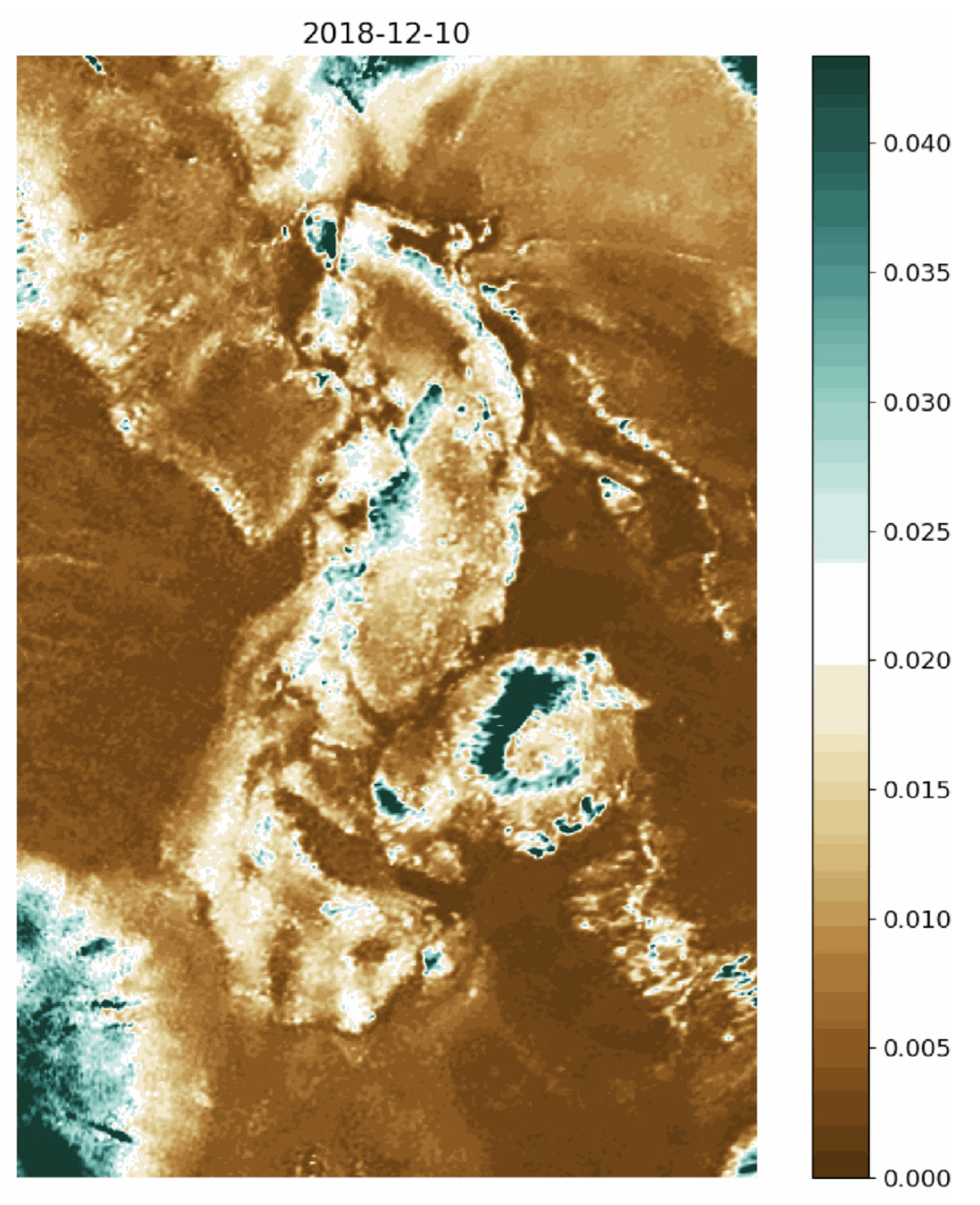
For halite nodules at SG, the source of water is atmospheric water vapor sourced from the adjacent Pacific Ocean in the form of fog (Figure 4; [44]). Changes in near-surface roughness were tracked at SG using co-polarized (VV) SAR images from the Sentinel-1 satellite (Figure 5). The relative roughness of the imaged surface influences the strength of the co-polarized SAR return signal [58]. The smoother the surface, the greater the reflection away from the sensor, resulting in a darker image. Rougher surfaces, on the other hand, produce a stronger return to the sensor and a brighter image. At SG, we observe brighter images with rougher surfaces during the austral spring and summer months when the salar is drier. Darker images, indicating a smoother surface, are observed during the austral fall and winter months when the salar is wetter. Surface and near-surface moisture levels are higher during the wetter months (Figure A1), and surface roughness is much lower, presumably due to dissolution of halite on the salar surface at centimeter spatial scales. Ostensibly, re-precipitation of halite during the drier months increases centimeter-scale surface roughness, resulting in brighter VV SAR images. These observations of seasonal changes in centimeter-scale surface roughness suggest either that condensed atmospheric water vapor is responsible for widespread dissolution of halite in the colder (wetter) fall and winter months, or that SG might not be disconnected from subsurface water sources, as Artieda et al. [44] indicated.
At SdP, a subsurface aquifer sources water. We have tracked changes in near-surface water content at SdP using cross-polarized SAR observations from the Sentinel-1 satellite (Figure 5). In general, seasonal changes in near-surface moisture can be inferred by observing changes in the dielectric properties [60,61]. During the dry cycle, the near-surface matrix is mostly air and gypsum clays with a very low dielectric constant and low radar backscatter return. Conversely, radar backscatter increases when the near-surface matrix contains water because the dielectric constant of water is much higher than air. In Figure 5, we infer changes in radar backscatter to reflect seasonal changes in subsurface water storage. When the water table is high, moisture wicked to the surface by capillary action replaces air in the near-surface matrix and radar backscatter increases. As the system dries during austral summer, the water table lowers, capillary-driven evaporation stops, and the radar backscatter intensity decreases because air replaces water within the near-surface matrix (Figure 5). The cycle of near-surface hydration and dehydration observed in the SAR data supports the model of gypsum dome and ridge formation proposed by Hinman et al. [33] that involves cyclic hydration and dehydration.
An elevated geotherm from magma bodies that feed the cones adjacent to Pajonales is important for driving water vapor and other gases upward (as evidenced by lined holes in many domes at SdP that are interpreted to have formed through gas release). Volcanic features are not only a good indicator of a locally elevated geotherm but can also provide hydraulic head to drive water upward. Zones of tectonic weakness channel volatiles upward to the salar—both deep, tectonically related fracture networks, as well as shallow networks related to volume changes in the salt crust. These shallow zones of weakness govern the patterns of salt constructs observed at the surface of SdP (Figure 3).
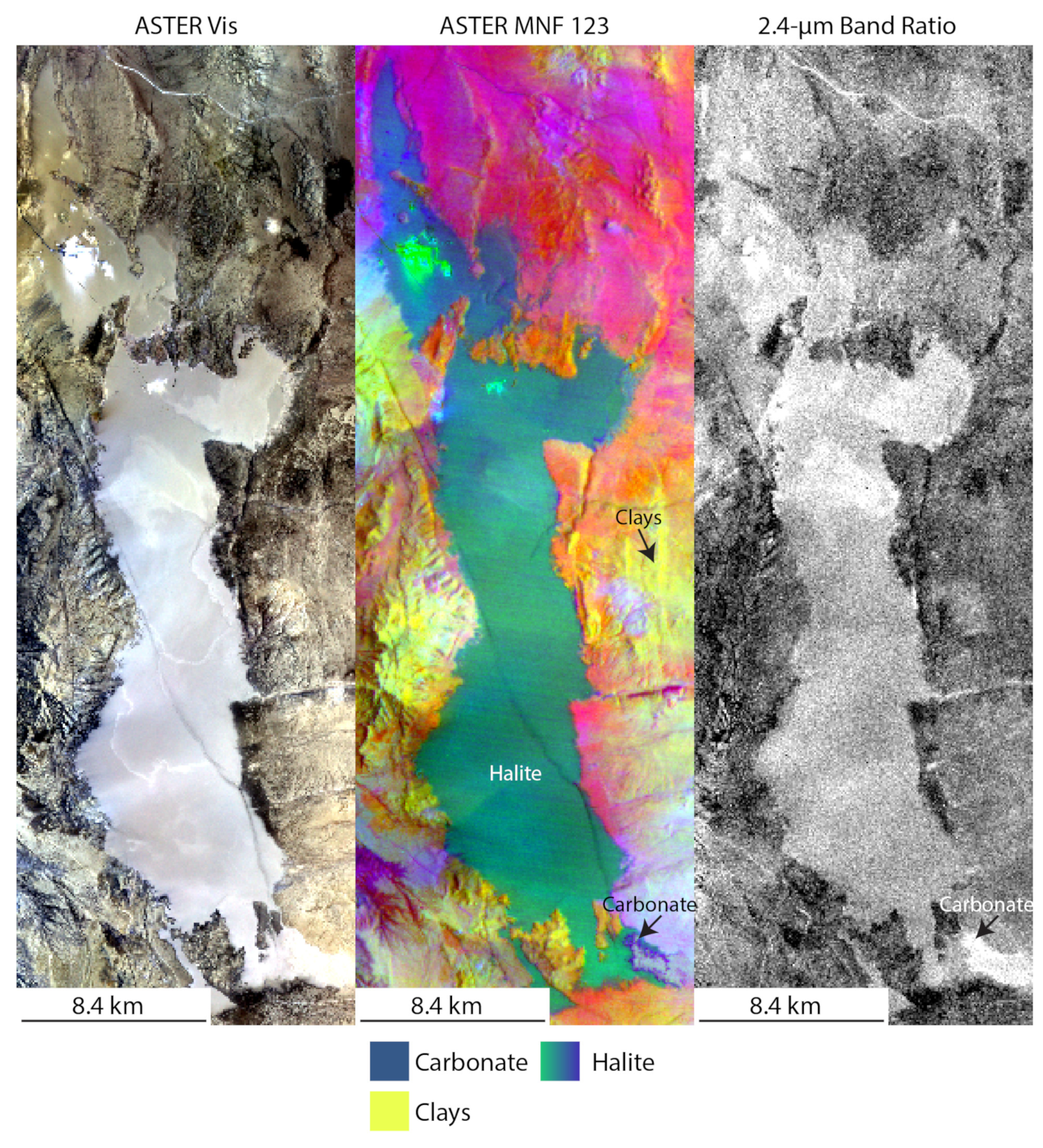
A minimum noise fraction transformation was applied to ASTER multispectral data over SG and SdP to assess variability in composition across the scene (Figure 6 and Figure 7). At SG, the salar is composed of halite. Small changes in the ratio of the 2.400 µm band to the 2.336 µm band indicate possible variations in a surficial carbonate or phyllosilicate layer across the salar (Figure 6). SdP is composed principally of three minerals: halite, sulfate, and carbonate (Figure 7, [62]). Our focus is on the gypsum portion of the salar, which is relatively hydrologically inactive at the surface compared to the rest of the salar (Figure 5). The results from our compositional analysis reveal that salt construct morphology is likely dependent on the composition of the salt. Whereas nodular forms are typical of halite, domical and ridge morphologies form in gypsum salt crusts [45].

3.2. Martian Salars with Possible Salt Constructs

To identify martian salars that could host salt constructs, we used insight gained by assessing the regional geologic phenomena that make salt construct formation possible in terrestrial salars. We searched for martian salars with a possibility for continued water activity after surface water disappeared. These salars: (1) are near volcanic centers that could provide both a heat source and hydraulic head to drive subsurface water to the surface, (2) are near ancient seas that could have sourced fog/precipitation, (3) have possible deep fracture networks, and/or (4) are in regions where deliquescence of calcium perchlorate is possible in the present day, and by inference, in the recent past [64]. We used the database of volcanic centers from Hargitati and Leone [65] along with paleo-shoreline values from Sholes et al. [66] for our search. For the locations of possible present-day deliquescence of calcium perchlorate, we used the results from [64]; specifically, their map of metastable brines on Mars showing the percentage of the year that calcium perchlorate salts can be in solution [67]. In their work, they paired the experimentally validated deliquescence relative humidity and efflorescence relative humidity of calcium perchlorate along with hourly results from a general circulation model, MarsWRF, to investigate the formation and persistence of calcium perchlorate brines. For our database of martian salars, we used data available from [55], which expanded the Osterloo et al. [22] dataset of martian salars to 641. Among these 641 salars, we identified 102 that met the above geographic criteria (Figure 8, Supplemental Data Table S1). Of these 102 martian salars, 17 are covered by HiRISE (Table 1).

3.2.1. Analysis of HiRISE Data

Of the 17 martian salars with regional geologic factors conducive to salt construct formation and with HiRISE coverage, 16 contain positive topographic features (Table 1). In some cases, the topographic constructs identified in salt-encrusted regions display characteristics unique to the features within the martian salars. Below, we describe the 16 martian salars with topographic constructs. Supplementary Data Table S1 contains a description of each salar investigated in this study. In referencing specific salars below, we use the identification number (Chl FID) given in [55].

Salars with Present-Day Deliquescence

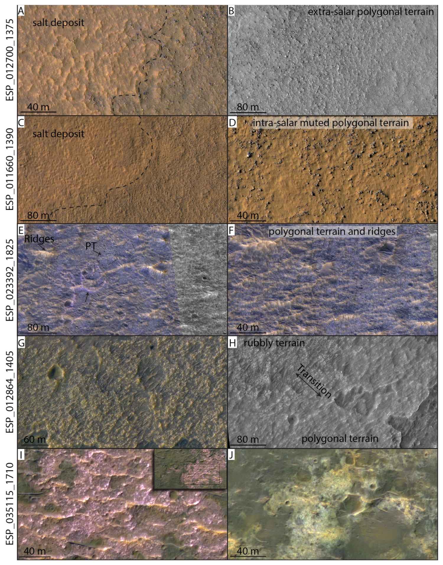
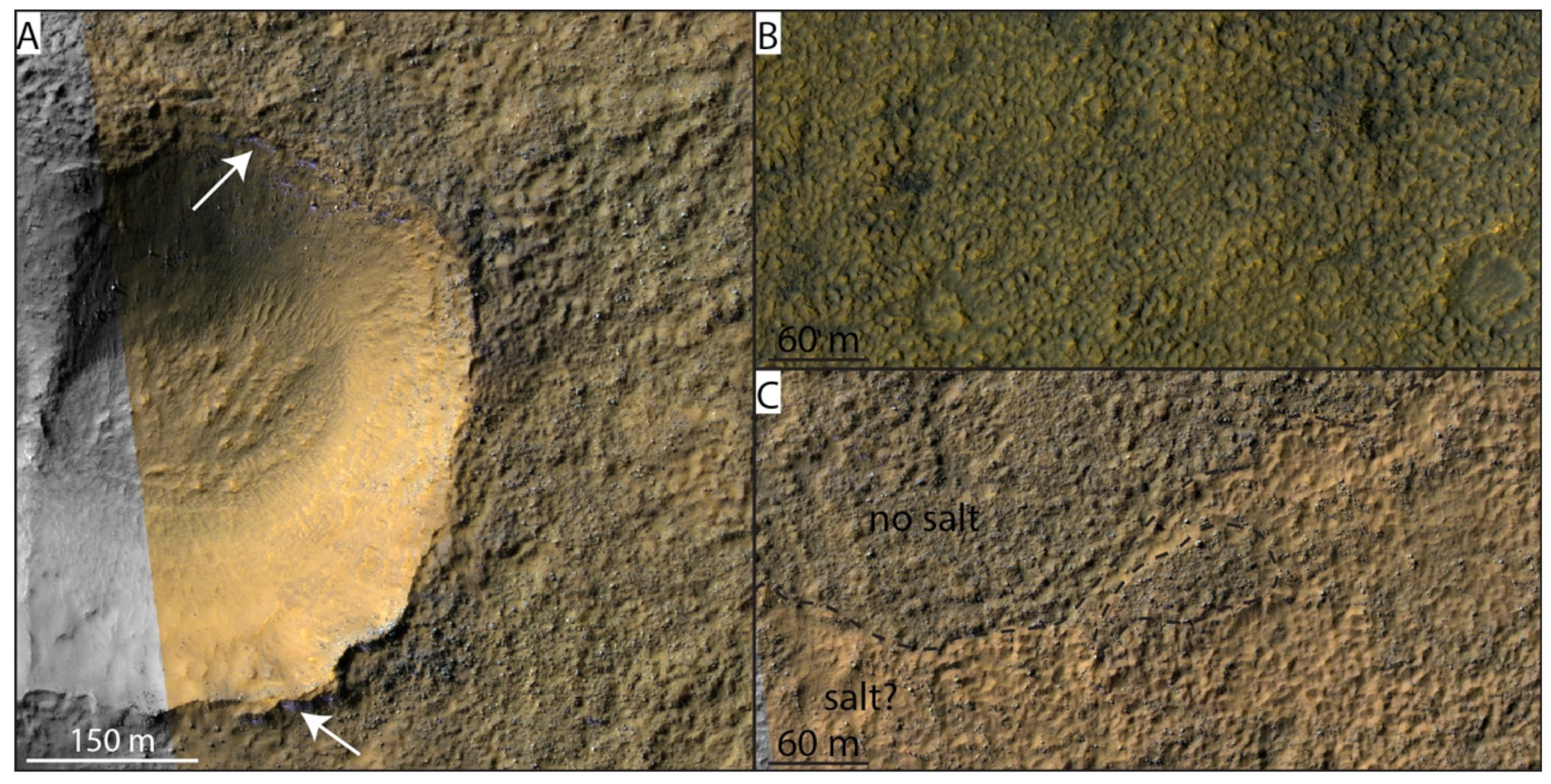
We identified 14 salars covered by HiRISE that occur where present-day deliquescence of calcium perchlorate is possible. These salars are at high southern latitudes, between −35° and −55°. In general, salars in this category appear yellow to orange in HiRISE IRB data, with less frequent purple/lavender coloration (Figure 9, Figure 10 and Figure 11). It should be noted that HiRISE IRB images are false color composites in which color differences are scene-dependent. We do not interpret composition from HiRISE IRB color. Our decision to include a description of color variations within HiRISE IRB scenes is an attempt to report a dataset that is consistent with previous studies of martian chloride deposits, e.g., [22,55], that included such descriptions. In most scenes, salars have well-defined boundaries; in some instances, e.g., deposit Chl FID 178 (Table 1), salt deposits are not clearly defined and appear to encrust pre-existing boulders or mounds, or as bright, meter-scale flat patches with diffuse margins.
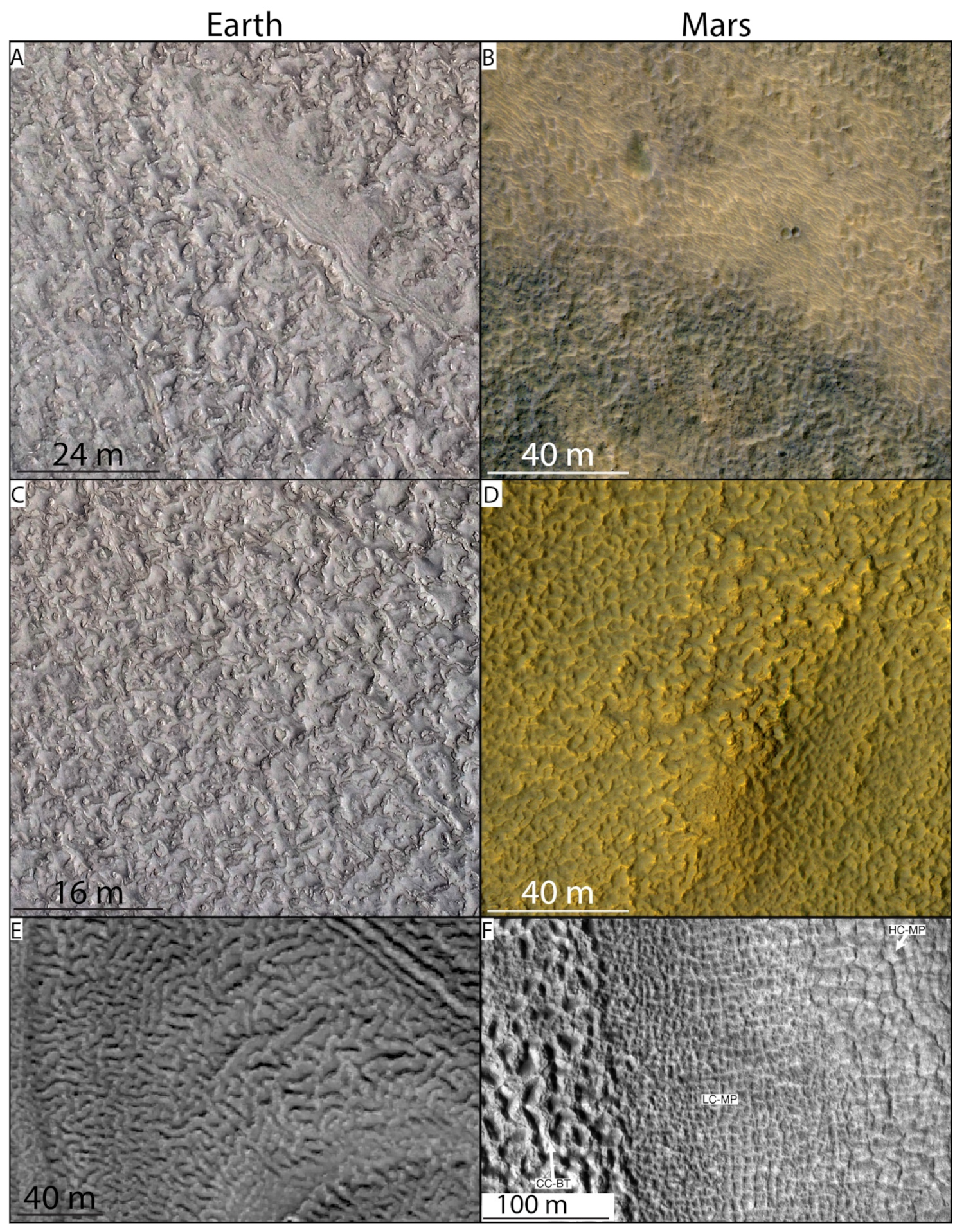
The terrains within salars with possible present-day deliquescence (Figure 9, Figure 10 and Figure 11) are typically knobby/hummocky and contain polygonal patterned ground with variable morphology that resembles “brain terrain” (Figure 12F)—a type of polygonal patterned ground interpreted to be related to thermal contraction and sublimation processes [68]. Thermal contraction and sublimation processes are consistent with the high southern latitude of these salars where subsurface ice is likely present [69,70,71,72]. Shallow subsurface ice is evidenced by bright, blue-colored layers observed in the walls of craters and other depressions in several scenes analyzed in this study (Figure 9F,G and Figure S1). Polygonal ground in the salars is defined variably by positive relief edges with low centers (similar to open cell brain terrain from [68]), and by negative relief edges with high centers (similar to closed-cell brain terrain from [68]). Polygons with positive relief centers often appear mound-like (e.g., Figure 9B and Figure 10H). Intra-salar polygonal terrain is typically distinct from similar, extra-salar polygonal terrain in that polygon morphologies are more pronounced with well-defined raised edges (Figure 9, Figure 10 and Figure 11). The presence of “brain” and hummocky terrains indicates possible widespread sublimation-driven landform development in many of the scenes. Wind erosion is also evidenced by the presence of aeolian features (possibly dunes) that align with ridges in several scenes.

Salars near Volcanic Features

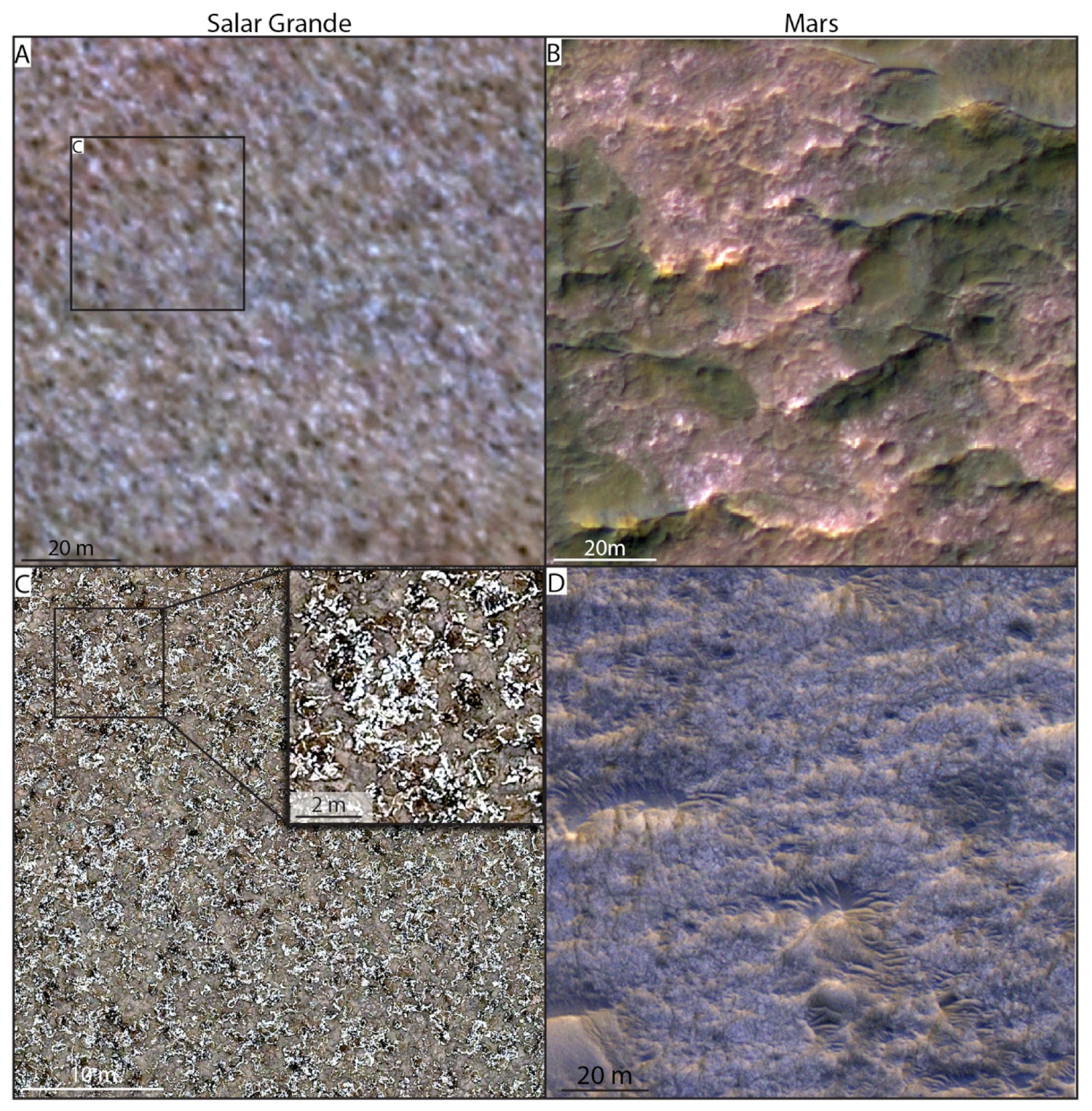
We identified three salars covered by HiRISE that occur near volcanic features (Figure 11E–J). These salars occur across a range of latitudes: 2.5°, −8.8°, and −39.4°. In contrast to salars with possible present-day deliquescence, salars near volcanic features appear light-toned and lavender in HiRISE IRB data, with less frequent orange coloration. In Chl FID 545 (lat = 2.5°), the salt deposit appears blue/purple with orange/pink ridges across the deposit (Figure 11E,F,I). Light-toned blue/lavender patches are observed and appear rough at submeter spatial scales. The roughness is possibly polygonal or nodular in its morphology, but it is difficult to identify because the spatial scale of the putative patterning is near the limit of the image resolution (Figure 13). Notably, polygonal terrain is not observed outside of bright salt deposits in this scene. Orange-toned ridges are aligned with the direction of dunes in the area.
Salar Chl FID 333 (lat = −8.8°, Figure 11I,J) has well-defined boundaries and appears lavender in HiRISE IRB, though some yellow deposits occur in the southern region of the scene. The lavender salt deposit appears rough in texture with quasi-polygonal terrain identified by its raised polygon rims and depressed centers. The yellow deposits appear smooth compared to the lavender deposit with rectangular polygonal terrain defined by raised polygon rims. Polygonal terrain is not observed outside the salt deposits. East–west trending, orange-toned ridges occur in the lavender salt deposit. The ridges have an apparent orange-toned capping unit and show evidence for boulders that have tumbled down their flanks. Dunes are observed throughout the scene, also trending east–west.
Salar Chl FID 136 (lat = −39.4°, Figure 11G,H) is light-toned, has well-defined boundaries, and appears orange and lavender in HiRISE IRB. The deposit is rubbly and comprises rectangular to polygonal blocks of light-toned material with dark sand between the blocks. Polygon terrain is observed in the salt deposit in some locations. The polygons are positive relief in their centers with negative relief defining their boundaries. In some areas, a gradational relationship is apparent between the blocky and polygonal salt morphologies (Figure 11H). Dunes are apparent across the scene and on top of the deposit, trending northeast. Sinuous ridges are observed in the area with salt deposits on their crests and flanks. “Brain terrain” is observed in the scene outside the salar to its north and south (Figure A2); it is unclear if the “brain terrain” is salt-encrusted.
Figure 8. Locations of martian salt deposits in relation to paleo-seas, volcanic features, and possible present-day deliquescence on Mars. (A) Density map of salt deposits (blue = low, orange = high) overlain on MOLA/HRSC blended topography. Red regions are volcanic terrain from Tanaka et al. (2014) [73]. Blue regions indicate possible paleo-sea levels from Sholes et al. (2021) [66]. (B) The same salt deposit density map as in (A) shown in relation to locations with possible present-day deliquescence. (C) The 102 salars that are proximal to volcanic features, seas, or occur where present-day deliquescence is possible. The 17 salars with HiRISE coverage analyzed in this study are indicated in blue.
Remotesensing 15 00314 g008
Figure 9. HiRISE images showing features in martian salars where present-day deliquescence is possible. In many scenes, widespread hummocky terrain gives evidence for pre-existing topography on which some salt features may have formed. Differences between intra-salar and extra-salar morphologies may be due to differential erosion or may be caused by the formation of salt-related features. (A) Martian salar (indicated by dashed black line) with domical and ridge morphologies. (B) Muted dome and ridge terrain, possibly salt-encrusted. (C) Light-toned, lavender and orange topographic features possibly comprising salt. Arrow indicates a circular form of these features. In some places, the light-toned material appears flat and not as a topographic feature. (D) Subset of (C) showing a “dimpled” terrain, c.f., “basketball terrain” from [74], with quasi-polygonal morphology, possibly related to salt in the area. (E) Polygonal terrain with low centers and high rims in a light-toned, orange, salt-encrusted area. Compare to darker regions that are not salt-encrusted with high centers and low rims. (F) Possible water ice observed in a crater rim. Note the hummocky/polygonal ground with high centers and low rims. (G) Crater with low-center mantle polygons (see Figure 12F and, c.f., Levy et al., 2009 [68]) as well as layered deposits, indicating possible ground ice in the region. (H) Orange-toned salt deposit with polygonal ridges and cross-cutting lavender-toned channels. (I) Orange-toned salt deposits (indicated by black dashed lines) exhibiting polygonal morphology with more distinctive raised rims than that observed in adjacent, dark-toned regions. A nearby depression shows bright, blue layers that are possibly water ice. (J) Zoomed-in region showing the difference between intra-salar and extra-salar polygonal morphologies.
Remotesensing 15 00314 g009
Figure 10. Features in martian salars where present-day deliquescence is possible. (A) Lavender-toned—possibly salt-rich—material ostensibly eroding from beneath a cap rock. (B) Large (~1 km along its primary axis) quasi-elliptical light-toned feature, possibly encrusted by salt. The feature appears as a depression and contains polygonal ridges and channels. Similar topographic features are not observed outside the deposit. (C) Polygonal terrain and ridges inside a salt deposit. Some areas appear “blocky” or “rubbly”. (D) A more contextual view of the polygonal terrain and ridges shown in (C). (E) Muted polygonal terrain and “tiger stripe” pattern with repeating dark and light orange-toned sinuous lineate features. (F) An alternate view of the polygonal terrain that resembles closed-cell brain terrain (see Figure 12F and, c.f., Levy et al., 2009 [68]) and “tiger stripe” terrain (c.f., Figure 12A,B). (G) Raised-rim polygonal terrain and channels in a salt deposit. Rubble/boulders are seen forming along polygon edges in some instances. (H) Arrows indicate circular and subcircular patterns of boulders in a light, lavender-toned salt deposit [75,76]. (I) Bright lavender-toned features in an orange putative salt deposit (dashed black outline) surrounded by high-center polygonal terrain possibly related to sublimation of ground ice. Note the morphologic difference between the salt-encrusted terrain and non-salt-encrusted terrain. (J) Polygonal and rubbly terrain in a lavender-toned salt deposit.
Remotesensing 15 00314 g010
Figure 11. Features in martian salars where present-day deliquescence is possible (AD) and proximal to volcanic features (EJ). (A) Raised-rim polygonal terrain within an orange-toned salt deposit (demarcated by dashed black line). Polygonal morphology is distinct from the surrounding terrain. (B) Polygonal terrain outside of the putative salt deposit. (C) Muted polygonal ground inside a possible salt deposit (marked by dashed black line). Note the distinct morphology within vs. outside the salt deposit. (D) Zoomed-in view of the polygonal ground in (C). Note that boulders form arcuate patterns around polygonal terrain in many places. (E) Polygonal terrain (PT) and ridges in a putative salt deposit. Dashed black line outlines an example patch of polygonal terrain in the region. (F) A zoomed-in view of the patchy polygonal terrain and orange-toned ridges in this putative salt deposit. (G) A putative salt deposit with rubbly/blocky character. Dark-toned sand is interspersed between possible blocks of salt. (H) Rubbly/blocky terrain appears to gradually transition into polygonal terrain in this salt deposit. (I) Light-toned lavender salt deposit that appears rough at HiRISE spatial resolution. Orange ridges cross-cut the deposit. (J) Yellow/white-colored possibly salt-encrusted patches are observed to the south of the lavender salt deposit shown in (I). These patches exhibit polygonal fracturing and appear smooth compared to the lavender deposits.
Remotesensing 15 00314 g011
Figure 12. Comparison between terrestrial salt features and martian features. (A) Domes and polygonal network of ridges at Salar de Pajonales (SdP). Note also the alternating dark- and light-toned striations of sand deposited via aeolian processes. (B) Polygonal network of raised ridges on Mars (ESP_023699_1390) with “tiger stripe” patterns that resemble the aeolian striations at SdP. (C) Domes and polygonal ridges at SdP. (D) Polygonal ridges on Mars (ESP_012864_1405) south of a salt deposit. It is unclear whether this terrain is salt-encrusted. Polygonal morphology could be caused by sublimation processes or could be related to salt deposition as is the case at SdP. Morphology resembles “closed-cell brain terrain” (Levy et al., 2009 [68]) as seen in panel F. (E) Polygonal salt ridges at Qaidam basin, China from Cheng et al. (2021) [77] that bear close resemblance to polygonal terrain at SdP and in salt basins on Mars. (F) Closed-cell brain terrain (CC_BT), low-center mantle polygons (LC-MP), and high-center mantle polygons (HC-MP) from Levy et al. (2009) [68]. These features were interpreted to form via sublimation processes from massive ground ice, but could be related to salt precipitation.
Remotesensing 15 00314 g012
Figure 13. Comparison between terrestrial salt features and martian features. (A) Halite nodules at Salar Grande (SG) at HiRISE spatial resolution. Image was generated through convolution with the HiRISE point spread function and rebinning to HiRISE ground sampling distance (GSD). At this spatial resolution, only clusters of halite nodules are visible. (B) A martian salar (ESP_035115_1710) with a light-toned lavender appearance containing bright rubbly terrain with appearance similar to nodules at SG. (C) A subset of SG at 2.2 cm/pixel spatial resolution, showing a more detailed view of halite nodules. (D) Rough-textured, light-toned martian salt deposit (ESP_023392_1825). The rough texture could represent nodular forms, similar to those at SG.
Remotesensing 15 00314 g013

4. Discussion

Topographic constructs were observed in all but one of the martian scenes investigated in this study. The strongest evidence for topographic constructs being salt-formed was found for salar Chl FID 333 because positive relief polygonal features were observed within, but not outside, the salar, which indicates that the positive relief polygonal rims may have required salt to be constructed. Other positive relief features in many of the scenes could be interpreted as wind-formed, evidenced by characteristics typical of erosion (a capping unit and float rocks) and alignment with dunes in the areas. At salar Chl FID 136, sinuous ridges occur and appear similar to salt-encrusted inverted fluvial channels observed in the Atacama Desert [78]. In most salars where present-day deliquescence of calcium perchlorate is possible, positive relief features were observed outside the salars with similar polygonal morphology to the positive relief features inside the salars. We interpret this to mean either that salt may have encrusted pre-existing polygonal topography, that the polygonal terrain formed after the salar was deposited and modified it, or that precipitation of salt may contribute to the widespread polygonal terrain in these scenes.
It is notable that differences between the characteristics of intra-salar and extra-salar topographic constructs were commonly observed. The difference in polygonal morphology inside versus outside many salt deposits belies some difference either in the mechanisms of their formation or in erosional processes [79]. Terrestrial ice-related landforms bear resemblance to martian “brain terrain” and the features observed in this study; for example, the “vermicular ridge features” of the Canadian Arctic described by Hibbard et al. [80] that form via paraglacial ice ablation. Although “brain terrain” has been interpreted to form via sublimation and thermal contraction followed by differential erosion [68], an alternative hypothesis is that salt precipitation may drive the formation of raised-rimmed polygonal terrains in some settings. Dang et al. [81] describe salt-constructed polygonal terrain in Qaidam basin, China with strikingly similar morphology to both martian brain terrain and the gypsum ridges of SdP (Figure 12). At Qaidam basin, precipitation of salt is necessary for the formation of its polygonal terrain [77,81].
It may be the case that intra-salar polygonal terrain formation was enhanced by the precipitation of salt, enabling larger and more well-formed polygons to form in the salt-rich areas (Figure 14) than in the surrounding terrain (Hypothesis I). In this model of polygonal terrain formation within salt deposits, ground ice would sublimate to produce water vapor at nested, cyclic timescales controlled by diurnal, seasonal, and obliquity-driven temperature changes. Water vapor traveling through an overlying salt-rich matrix, or massive salt deposit, could interact with the salt through adsorption, absorption, and deliquescence, e.g., [82]. Volume expansion of salts through hydration would disrupt the surface, possibly forming mounds, ridges, or nodules in a similar fashion to the gypsum ridges observed at SdP [33] or halite nodules observed at SG. A reasonable expectation is that ridges would naturally form in polygonal networks to efficiently accommodate the increase in volume; however, it should be noted that the composition of the salt phase on Mars is not well constrained and different morphologies arise from different compositions as is observed between the terrestrial salars SG and SdP. Efflorescence would preferentially occur from subsurface brines at regions of locally elevated evaporation potential [44,83] to form salt deposits in the near surface or on the surface, following pre-existing zones of weakness such as those formed by earlier stages of desiccation and polygonal cracking [41]. As salt is deposited, this would contribute to a feedback loop because the local topographic highs would drive higher evaporation rates, as is observed with halite nodules at SG [44]. Salt construct morphology could be further altered through dissolution, leading to central collapse of domes and ridges. This model for salt construct formation, in which water vapor is sourced through sublimation of ground ice to form brines, could apply to present-day Mars. However, in the past, especially in regions where an elevated geotherm is likely (i.e., near volcanic centers), brines could have been stable in the subsurface, obviating the need for brine formation via water vapor sublimated from ground ice.
An alternative model for topographic constructs in martian salt deposits is that polygonal terrain formed via sublimation, thermal contraction, and differential erosion, e.g., [84], prior to salt deposition (Hypothesis II). Following the formation of polygonal terrain, salt may have encrusted these features, making them more resistant to erosion and retaining relatively well-preserved polygonal forms compared to their surroundings. The process for salt encrustation may have been via precipitation from (possibly glacially fed) standing bodies of water [8,41,42,55,85,86,87], through precipitation of salt from (hydrothermal) ground water [88], or through efflorescence from upward-mobile deliquesced brines [67,82]. There are, however, several problems with this alternative hypothesis. If the polygonal terrain formed prior to salt deposition, there must be an explanation for how the polygonal forms survived the processes that led to salt deposition. Salt deposition by either precipitation from surface water or from hydrothermal water activity may erase the polygonal terrain originally emplaced by processes related to ground ice. Alternatively, sublimation-driven polygonal terrain could have altered salt deposits after their formation, but in this case one might expect polygonal forms with raised centers rather than raised rims [84]. Note that this model would only apply to regions where ground ice was likely present and may not explain equatorial polygonal forms. The multiple shortcomings of Hypothesis II lead us to favor Hypothesis I as a possible explanation for the formation of topographic constructs in martian salt deposits; however, more observations (on Earth and Mars) and modeling should be carried out to test these hypotheses.
The combined presence of ground ice and salt deposits in an area where present-day deliquescence is possible could foster small-scale, transiently habitable conditions in the near surface of Mars and offers an enticing destination for life-detection missions. The interaction of salts with ground water and ice may be a widespread and active process shaping the surface of Mars [82,89]. Salts have been consistently observed on the surface of Mars by rovers at Gusev [90,91,92], Gale [26,93,94], and Jezero [15,95]. Although we have not observed features in images obtained by rovers that are indicative of salt constructs, future exploration by Curiosity and Perseverance at Gale and Jezero craters, respectively, should target such features if they are observed.
The formation of martian polygonal terrains [41], e.g., [68,96,97], especially in areas known to contain salt, should be revisited with the alternative hypothesis that they are salt-constructed landforms. Additionally, the relationship between martian salar compositions [42,98,99] and polygonal forms is an area that deserves further research. As we have observed at SG and SdP, the morphology of salt constructs is controlled by salt composition and the mechanisms for salt construct formation. Future work could model salt construct formation on Mars to understand what morphologies we might expect to observe on the surface. Lastly, future searches for martian salt constructs could be expanded to include areas surrounding paleo-lakes and additional data sources, such as the Mars Orbiter Camera (MOC) [100] and the Colour and Stereo Surface Imaging System (CaSSIS) [101].

5. Conclusions

Across two salt-encrusted environments in northern Chile, one in the Atacama and the other in the Altiplano, with distinct evaporite mineralogy, the activity of water resulted in decimeter- to meter-tall topographic constructs with nanometer- to millimeter-scale porosity conducive to the persistence of endolithic microbial life. We hypothesize that decimeter- to meter-tall salt constructs may be general indicators for enhanced and sustained habitability in salt-encrusted paleo-lake basins because their formation requires the continued action of water after the lake has dried. Therefore, salt constructs offer a unique opportunity to precisely target, from orbit, high-priority destinations for biosignature- and life-detection missions. In this study, we detected features across 16 martian salars that are putative salt constructs, some of which may be actively forming today. Future investigations of these features could explore the role that salt precipitation may play in their formation, the possible differences in salt construct morphology that may manifest on Mars compared to Earth, and expand on our search by including paleo-lakes as sites of interest and additional datasets such as MOC and CaSSIS.
Although salt constructs may be difficult to confidently identify from orbit [102], salars on Mars should be the targets of continued high-resolution investigations, and efforts should be made to distinguish salt constructs from other positive topographic features with which they could be confused. Salt constructs may be one of the few features, other than (fossil) hydrothermal vents, that have a high potential to both host and preserve microbial organisms in situ, and that are specific targets, possibly identifiable from orbit, to which a rover could be driven. Salt constructs would have been habitable at the time when liquid water was present on the surface up to, perhaps, the present day. These characteristics make salt constructs attractive targets for future missions to Mars.

Supplementary Materials

The following supporting information can be downloaded at: https://www.mdpi.com/article/10.3390/rs15020314/s1, Table S1: Descriptions of martian salars investigated with HiRISE.

Author Contributions

Conceptualization, M.S.P., N.W.H., K.W.-R.; methodology, M.S.P., M.M., M.H.H.; formal analysis, M.S.P., M.M., E.G.R.-V.; investigation, M.S.P., M.M; resources, M.S.P., M.M., E.G.R.-V.; data curation, M.S.P., M.M., M.H.H., E.G.R.-V.; writing—original draft preparation, M.S.P.; writing—review and editing, all co-authors; visualization, M.S.P., M.M., M.H.H.; supervision, M.S.P.; project administration, N.A.C.; funding acquisition, N.A.C. All authors have read and agreed to the published version of the manuscript.

Funding

This research was funded by NASA NAI, grant number NNX15BB01A, “Changing Planetary Environments and the Fingerprints of Life”.

Data Availability Statement

All data used in this article can be found publicly available on the web.

Acknowledgments

We thank the 3 reviewers who provided constructive comments and suggestions that improved the quality of this manuscript.

Conflicts of Interest

The authors declare no conflict of interest. The funders had no role in the design of the study; in the collection, analyses, or interpretation of data; in the writing of the manuscript; or in the decision to publish the results.

Appendix A

Figure A1. Cross-polarized (VH) radar backscatter animation of Salar Grande. Still frame from a time series animation that tracks changes in near-surface moisture content of the salar. The surface is drier during austral summer and wetter during austral winter. For the full animation, please see [59].
Remotesensing 15 00314 g0a1
Figure A2. Possible ground ice-related features in martian salars. (A) Evidence for ground ice exposed in the rim of a depression (white arrows) in HiRISE scene ESP_045905_1425. (B) Patterned ground that resembles closed-cell brain terrain (Levy et al., 2009 [68]) and polygonal ridges at Salar de Pajonales (Figure 12). (C) Difference between intra-salar and extra-salar polygonal terrain in HiRISE scene ESP_045905_1425. Extra-salar polygonal terrain could be related to sublimation of ground ice. Differences between polygonal morphologies within and outside the salt deposit could be due to better preservation provided by salt encrustation or could be due to continuous salt deposition contemporaneous with erosion.
Remotesensing 15 00314 g0a2

References

  1. Cabrol, N.A.; Grin, E.A. The Evolution of Lacustrine Environments on Mars: Is Mars Only Hydrologically Dormant? Icarus 2001, 149, 291–328. [Google Scholar] [CrossRef]
  2. Cabrol, N.A.; Grin, E.A. (Eds.) Searching for lakes on Mars: Four decades of exploration. In Lakes on Mars; Elsevier: Amsterdam, The Netherlands, 2010; pp. 1–29. [Google Scholar] [CrossRef]
  3. Cabrol, N.A.; Grin, E.A.; Hock, A.N. Mitigation of environmental extremes as a possible indicator of extended habitat sustainability for lakes on early Mars. In Proceedings of the SPIE Optical Engineering + Application, San Diego, CA, USA, 26–30 August 2007; Volume 6694, p. 669410. [Google Scholar] [CrossRef] [Green Version]
  4. Ehlmann, B.L.; John, F.M.; Caleb, I.F.; Samuel, C.S.; James, W.H.I.; David, J.D.M.; John, A.G.; Scott, L.M. Clay minerals in delta deposits and organic preservation potential on Mars. Nat. Geosci. 2008, 1, 355. [Google Scholar] [CrossRef]
  5. Di Achille, G.; Hynek, B.M. Ancient ocean on Mars supported by global distribution of deltas and valleys. Nat. Geosci. 2010, 3, 459–463. [Google Scholar] [CrossRef]
  6. Goudge, T.A.; Aureli, K.L.; Head, J.W.; Fassett, C.I.; Mustard, J.F. Classification and analysis of candidate impact crater-hosted closed-basin lakes on Mars. Icarus 2015, 260, 346–367. [Google Scholar] [CrossRef]
  7. Warren-Rhodes, K.; Phillips, M.; Davila, A.; McKay, C.P. Insights of Extreme Desert Ecology to the Habitats and Habitability of Mars. In Microbiology of Hot Deserts; Ramond, J.-B., Cowan, D.A., Eds.; Springer International Publishing: Cham, Switzerland, 2022; pp. 235–291. [Google Scholar] [CrossRef]
  8. Osterloo, M.M.; Hamilton, V.E.; Bandfield, J.L.; Glotch, T.D.; Baldridge, A.M.; Christensen, P.R.; Tornabene, L.L.; Anderson, F.S. Chloride-bearing materials in the southern highlands of Mars. Science 2008, 319, 1651. [Google Scholar] [CrossRef] [PubMed] [Green Version]
  9. Davila, A.F.; Duport, L.G.; Melchiorri, R.; Jänchen, J.; Valea, S.; de Los Rios, A.; Fairén, A.G.; Möhlmann, D.; McKay, C.P.; Ascaso, C.; et al. Hygroscopic salts and the potential for life on Mars. Astrobiology 2010, 10, 617. [Google Scholar] [CrossRef] [Green Version]
  10. Onstott, T.C.; Ehlmann, B.L.; Sapers, H.; Coleman, M.; Ivarsson, M.; Marlow, J.J.; Neubeck, A.; Niles, P. Paleo-Rock-Hosted Life on Earth and the Search on Mars: A Review and Strategy for Exploration. Astrobiology 2019, 19, 123–1262. [Google Scholar] [CrossRef]
  11. Ivarsson, M.; Lindgren, P. The Search for Sustainable Subsurface Habitats on Mars, and the Sampling of Impact Ejecta. Sustainability 2010, 2, 1969–1990. [Google Scholar] [CrossRef] [Green Version]
  12. Cushing, G.E. Mars Global Cave Candidate Catalog PDS4 Archive Bundle. In PDS Cartography Imaging Sciences Node (IMG); NASA: Washington, DC, USA, 2015. [Google Scholar] [CrossRef]
  13. Salese, F.; Pondrelli, M.; Neeseman, A.; Schmidt, G.; Ori, G.G. Geological Evidence of Planet-Wide Groundwater System on Mars. J. Geophys. Res. Planets 2019, 124, 374–395. [Google Scholar] [CrossRef] [Green Version]
  14. Hays, L.E.; Graham, H.V.; Des Marais, D.J.; Hausrath, E.M.; Horgan, B.; McCollom, T.M.; Parenteau, M.N.; Potter-McIntyre, S.L.; Williams, A.J.; Lynch, K.L. Biosignature Preservation and Detection in Mars Analog Environments. Astrobiology 2017, 17, 363–400. [Google Scholar] [CrossRef] [Green Version]
  15. Scheller, E.L.; Hollis, J.R.; Cardarelli, E.L.; Steele, A.; Beegle, L.W.; Bhartia, R.; Conrad, P.; Uckert, K.; Sharma, S.; Ehlmann, B. First-results from the Perseverance SHERLOC Investigation: Aqueous Alteration Processes and Implications for Organic Geochemistry in Jezero Crater, Mars. In Proceedings of the LPSC 2022, Woodlands, TX, USA, 7–11 March 2022. [Google Scholar]
  16. Haltigin, T.; Hauber, E.; Kminek, G.; Meyer, M.A.; Agee, C.B.; Busemann, H.; Carrier, B.L.; Glavin, D.P.; Hays, L.E.; Marty, B.; et al. Rationale and Proposed Design for a Mars Sample Return (MSR) Science Program. Astrobiology 2022, 22, S27–S56. [Google Scholar] [CrossRef]
  17. Warren-Rhodes, K.; Cabrol, N.; Phillips, M.; Tebes, C.; Hinman, N.W.; Rhodes, K.; Ayma, D.; Bishop, J.; Boyle, L.; Chong-díaz, G.; et al. Orbit to Ground Framework to Decode and Predict Biosignature Patterns from Terrestrial Analogues. Nat. Astron. 2023, in press. [Google Scholar]
  18. Sedell, J.R.; Reeves, G.H.; Hauer, F.R.; Stanford, J.A.; Hawkins, C.P. Role of refugia in recovery from disturbances: Modern fragmented and disconnected river systems. Environ. Manag. 1990, 14, 711–724. [Google Scholar] [CrossRef]
  19. Carrier, B.L.; Beaty, D.W.; Meyer, M.A.; Blank, J.G.; Chou, L.; DasSarma, S.; Des Marais, D.J.; Eigenbrode, J.L.; Grefenstette, N.; Lanza, N.L.; et al. Mars Extant Life: What’s Next? Conference Report. Astrobiology 2020, 20, 785–814. [Google Scholar] [CrossRef]
  20. Davila, A.F.; Schulze-Makuch, D. The Last Possible Outposts for Life on Mars. Astrobiology 2016, 16, 159. [Google Scholar] [CrossRef] [Green Version]
  21. Cabrol, N.A. Tracing a modern biosphere on Mars. Nat. Astron. 2021, 5, 210–212. [Google Scholar] [CrossRef]
  22. Osterloo, M.M.; Anderson, F.S.; Hamilton, V.E.; Hynek, B.M. Geologic context of proposed chloride-bearing materials on Mars. J. Geophys. Res. Planets 2010, 115, E10012. [Google Scholar] [CrossRef]
  23. Sánchez-García, L.; Aeppli, C.; Parro, V.; Fernández-Remolar, D.; García-Villadangos, M.; Chong-Diaz, G.; Blanco, Y.; Carrizo, D. Molecular biomarkers in the subsurface of the Salar Grande (Atacama, Chile) evaporitic deposits. Biogeochemistry 2018, 140, 31–52. [Google Scholar] [CrossRef] [Green Version]
  24. Fernández-Remolar, D.C.; Chong-Díaz, G.; Ruíz-Bermejo, M.; Harir, M.; Schmitt-Kopplin, P.; Tziotis, D.; Gómez-Ortíz, D.; García-Villadangos, M.; Martín-Redondo, M.P.; Gómez, F.; et al. Molecular preservation in halite- and perchlorate-rich hypersaline subsurface deposits in the Salar Grande basin (Atacama Desert, Chile): Implications for the search for molecular biomarkers on Mars. J. Geophys. Res. Biogeosci. 2013, 118, 922–939. [Google Scholar] [CrossRef]
  25. Schreder-Gomes, S.I.; Benison, K.C.; Bernau, J.A. 830-million-year-old microorganisms in primary fluid inclusions in halite. Geology 2022, 50, 918–922. [Google Scholar] [CrossRef]
  26. Thomas, N.H.; Ehlmann, B.L.; Meslin, P.-Y.; Rapin, W.; Anderson, D.E.; Rivera-Hernández, F.; Forni, O.; Schröder, S.; Cousin, A.; Mangold, N.; et al. Mars Science Laboratory Observations of Chloride Salts in Gale Crater, Mars. Geophys. Res. Lett. 2019, 46, 10754–10763. [Google Scholar] [CrossRef] [PubMed] [Green Version]
  27. Stromberg, J.M.; Parkinson, A.; Morison, M.; Cloutis, E.; Casson, N.; Applin, D.; Poitras, J.; Marti, A.M.; Maggiori, C.; Cousins, C.; et al. Biosignature detection by Mars rover equivalent instruments in samples from the CanMars Mars Sample Return Analogue Deployment. Planet. Space Sci. 2019, 176, 104683. [Google Scholar] [CrossRef] [Green Version]
  28. Barbieri, R.; Stivaletta, N. Continental evaporites and the search for evidence of life on Mars. Geol. J. 2011, 46, 513–524. [Google Scholar] [CrossRef]
  29. Cabrol, N.A.; Wettergreen, D.; Warren-Rhodes, K.; Grin, E.A.; Moersch, J.; Diaz, G.C.; Cockell, C.S.; Coppin, P.; Demergasso, C.; Dohm, J.M.; et al. Life in the Atacama: Searching for life with rovers (science overview). J. Geophys. Res. Biogeosci. 2007, 112. [Google Scholar] [CrossRef] [Green Version]
  30. Davila, A.F.; Gómez-Silva, B.; De Los Rios, A.; Ascaso, C.; Olivares, H.; McKay, C.P.; Wierzchos, J. Facilitation of endolithic microbial survival in the hyperarid core of the Atacama Desert by mineral deliquescence. J. Geophys. Res. Biogeosci. 2008, 113. [Google Scholar] [CrossRef] [Green Version]
  31. Ruch, J.; Warren, J.K.; Risacher, F.; Walter, T.R.; Lanari, R. Salt lake deformation detected from space. Earth Planet. Sci. Lett. 2012, 331, 120–127. [Google Scholar] [CrossRef]
  32. Warren-Rhodes, K.; Cabrol, N.; Hinman, N.W.; Tebes, C.; Rodriguez, C.; Phillips, M.S.; Demergasso, C.; Chong-díaz, G.; Moersch, J. Landscape Ecology of Photosynthetic Communities in the Mars Analog Salar de Pajonales, Chile. In Proceedings of the 2019 Astrobiology Science Conference, Seattle, WA, USA, 24–28 June 2019. [Google Scholar]
  33. Hinman, N.W.; Hofmann, M.H.; Warren-Rhodes, K.; Phillips, M.S.; Noffke, N.; Cabrol, N.A.; Chong Diaz, G.; Demergasso, C.; Tebes-Cayo, C.; Cabestrero, O.; et al. Surface Morphologies in a Mars-Analog Ca-Sulfate Salar, High Andes, Northern Chile. Front. Astron. Space Sci. 2022, 8, 235. [Google Scholar] [CrossRef]
  34. Houston, J.; Hartley, A.J. The central Andean west-slope rainshadow and its potential contribution to the origin of hyper-aridity in the Atacama Desert. Int. J. Climatol. 2003, 23, 1453–1464. [Google Scholar] [CrossRef]
  35. Clarke, J.D.A. Antiquity of aridity in the Chilean Atacama Desert. Geomorphology 2006, 73, 101–114. [Google Scholar] [CrossRef]
  36. Chong-Díaz, G. The cenozoic saline deposits of the Chilean Andes between 18°00′ and 27°00′ south latitude. In The Southern Central Andes; Lecture Notes in Earth Sciences; Springer: Berlin/Heidelberg, Germany, 1988; Volume 17. [Google Scholar]
  37. Risacher, F.; Alonso, H.; Salazar, C. The origin of brines and salts in Chilean salars: A hydrochemical review. Earth Sci. Rev. 2003, 63, 249–293. [Google Scholar] [CrossRef]
  38. Cabrol, N.A.; Feister, U.; Häder, D.-P.; Piazena, H.; Grin, E.A.; Klein, A. Record solar UV irradiance in the tropical Andes. Front. Environ. Sci. 2014, 2, 19. [Google Scholar] [CrossRef] [Green Version]
  39. Cabrol, N.A.; Grin, E.A.; Chong, G.; Minkley, E.; Hock, A.N.; Yu, Y.; Bebout, L.; Fleming, E.; Häder, D.P.; Demergasso, C.; et al. The High-Lakes Project. J. Geophys. Res. Biogeosci. 2009, 114. [Google Scholar] [CrossRef] [Green Version]
  40. Piatek, J.L.; Hardgrove, C.; Moersch, J.E.; Drake, D.M.; Wyatt, M.B.; Rampey, M.; Carlisle, O.; Warren-Rhodes, K.; Dohm, J.M.; Hock, A.N.; et al. Surface and subsurface composition of the Life in the Atacama field sites from rover data and orbital image analysis. J. Geophys. Res. Biogeosci. 2007, 112. [Google Scholar] [CrossRef] [Green Version]
  41. El-Maarry, M.R.; Pommerol, A.; Thomas, N. Analysis of polygonal cracking patterns in chloride-bearing terrains on Mars: Indicators of ancient playa settings. J. Geophys. Res. Planets 2013, 118, 2263–2278. [Google Scholar] [CrossRef] [Green Version]
  42. Glotch, T.D.; Bandfield, J.L.; Wolff, M.J.; Arnold, J.A.; Che, C. Constraints on the composition and particle size of chloride salt-bearing deposits on Mars. J. Geophys. Res. Planets 2016, 121, 454–471. [Google Scholar] [CrossRef] [Green Version]
  43. Hudec, M.R.; Jackson, M.P.A. Terra infirma: Understanding salt tectonics. Earth-Sci. Rev. 2007, 82, 1–28. [Google Scholar] [CrossRef]
  44. Artieda, O.; Davila, A.; Wierzchos, J.; Buhler, P.; Rodríguez-Ochoa, R.; Pueyo, J.; Ascaso, C. Surface evolution of salt-encrusted playas under extreme and continued dryness. Earth Surf. Process. Landf. 2015, 40, 1939–1950. [Google Scholar] [CrossRef]
  45. Warren, J.K. Evaporites: A Geological Compendium; Springer International Publishing AG: Cham, Switzerland, 2016. [Google Scholar]
  46. Farías, M.; Contreras, M.; Rasuk, M.; Kurth, D.; Flores, M.; Poiré, D.; Novoa, F.; Visscher, P. Characterization of bacterial diversity associated with microbial mats, gypsum evaporites and carbonate microbialites in thalassic wetlands: Tebenquiche and La Brava, Salar de Atacama, Chile. Extremophiles 2014, 18, 311–329. [Google Scholar] [CrossRef]
  47. D’Almeida, R.E.; García, M.E.; Pérez, M.F.; Farías, M.E.; Dib, J.R. Novel nematode species in living stromatolites in the Andean Puna. Invertebr. Zool. 2019, 16, 211–218. [Google Scholar] [CrossRef]
  48. Ecrilla, O. Origen and evolution of gypsum stromatolites in salars of the Andes highlands, northern Chile. Andean Geol. 2019, 46, 211–222. [Google Scholar]
  49. Gutiérrez, F.; Cooper, A. 6.33 Surface Morphology of Gypsum Karst. Treatise Geomorphol. 2013, 6, 425–437. [Google Scholar]
  50. Rasuk, M.; Kurth, D.; Flores, M.; Contreras, M.; Novoa, F.; Poire, D.; Farias, M. Microbial Characterization of Microbial Ecosystems Associated to Evaporites Domes of Gypsum in Salar de Llamara in Atacama Desert. Microb. Ecol. 2014, 68, 483–494. [Google Scholar] [CrossRef] [PubMed]
  51. Szynkiewicz, A.; Moore, C.H.; Glamoclija, M.; Bustos, D.; Pratt, L.M. Origin of coarsely crystalline gypsum domes in a saline playa environment at the White Sands National Monument, New Mexico. J. Geophys. Res. 2010, 115, F02021. [Google Scholar] [CrossRef] [Green Version]
  52. McEwen, A.S.; Eliason, E.M.; Bergstrom, J.W.; Bridges, N.T.; Hansen, C.J.; Delamere, W.A.; Grant, J.A.; Gulick, V.C.; Herkenhoff, K.E.; Keszthelyi, L.; et al. Mars Reconnaissance Orbiter’s High Resolution Imaging Science Experiment (HiRISE). J. Geophys. Res. Planets 2007, 112. [Google Scholar] [CrossRef] [Green Version]
  53. Werner, C. GAMMA SAR and interferometric processing software. In Proceedings of the ERS-Envisat Symposium, Gothenburg, Sweden, 16–20 October 2000; Available online: https://cir.nii.ac.jp/crid/1573387450588271232 (accessed on 14 September 2022).
  54. ASF DAAC. Contains Modified Copernicus Sentinel Data 2022, Processed by ESA. 2022. Available online: https://sentinels.copernicus.eu/web/sentinel/sentinel-data-access (accessed on 14 September 2022).
  55. Leask, E.K.; Ehlmann, B.L. Evidence for Deposition of Chloride on Mars From Small-Volume Surface Water Events Into the Late Hesperian-Early Amazonian. AGU Adv. 2022, 3, e2021AV000534. [Google Scholar] [CrossRef]
  56. Hartley, A.J.; Chong, G. Late Pliocene age for the Atacama Desert: Implications for the desertification of western South America. Geology 2002, 30, 43–46. [Google Scholar] [CrossRef]
  57. Houston, J. Evaporation in the Atacama Desert: An empirical study of spatio-temporal variations and their causes. J. Hydrol. 2006, 330, 402–412. [Google Scholar] [CrossRef]
  58. Meyer, F. Spaceborne Synthetic Aperture Radar: Principles, data access, and basic processing techniques. In Synthetic Aperture Radar (SAR) Handbook: Comprehensive Methodologies for Forest Monitoring and Biomass Estimation; SERVIR Global Science Coordination Office: Huntsville, AL, USA, 2019; pp. 21–64. [Google Scholar]
  59. Phillips, M. Supplementary files for “Salt constructs in paleo-lake basins as high-priority astrobiology targets” published in Remote Sensing. Zenodo 2022. [Google Scholar] [CrossRef]
  60. Ulaby, F.T.; Batlivala, P.P.; Dobson, M.C. Microwave Backscatter Dependence on Surface Roughness, Soil Moisture, and Soil Texture: Part I-Bare Soil. IEEE Trans. Geosci. Electron. 1978, 16, 286–295. [Google Scholar] [CrossRef]
  61. Behari, J. Microwave Dielectric Behaviour of Wet Soils; Springer: Dordrecht, The Netherlands, 2006; Available online: https://books.google.com/books?id=dsM4wfFaa7AC (accessed on 9 August 2022).
  62. Rodríguez-Albornoz, C. Geología de salar de Pajonales (7.209.000-7.226.500 N.-510.000-530.000 E) y antecedentes de su microbiota, Antofagasta, norte de Chile. Master’s Thesis, Universidad Católica del Norte, Antofagasta, Chile, 2018. [Google Scholar]
  63. DeCelles, P.; Zandt, G.; Beck, S.; Currie, C.; Ducea, M.; Kapp, P.; Gehrels, G.; Carrapa, B.; Quade, J.; Schoenbohm, L. Cyclical orogenic processes in the Cenozoic central Andes. Geol. Soc. Am. Mem. 2014, 212, 459–490. [Google Scholar]
  64. Rivera-Valentín, E.G.; Chevrier, V.F.; Soto, A.; Martínez, G. Distribution and habitability of (meta)stable brines on present-day Mars. Nat. Astron. 2020, 4, 756–761. [Google Scholar] [CrossRef]
  65. Hargitai, H.; Leone, G. Volcanic Channels and Volcanic Features on Mars. In Mars: A Volcanic World; Leone, G., Ed.; Springer International Publishing: Cham, Switzerland, 2021; pp. 95–110. [Google Scholar] [CrossRef]
  66. Sholes, S.F.; Dickeson, Z.I.; Montgomery, D.R.; Catling, D.C. Where are Mars’ Hypothesized Ocean Shorelines? Large Lateral and Topographic Offsets Between Different Versions of Paleoshoreline Maps. J. Geophys. Res. Planets 2021, 126, e2020JE006486. [Google Scholar] [CrossRef]
  67. Rivera-Valentín, E.G. Distribution and Habitability of Meta-Stable Brines on Present-Day Mars (Figures and Data) 2020. Available online: https://figshare.com/articles/dataset/DISTRIBUTION_AND_HABITABILITY_OF_META_STABLE_BRINES_ON_PRESENT-DAY_MARS_/11907984 (accessed on 6 September 2022).
  68. Levy, J.S.; Head, J.W.; Marchant, D.R. Concentric crater fill in Utopia Planitia: History and interaction between glacial ‘brain terrain’ and periglacial mantle processes. Icarus 2009, 202, 462–476. [Google Scholar] [CrossRef]
  69. Fanale, F.P.; Salvail, J.R.; Zent, A.P.; Postawko, S.E. Global distribution and migration of subsurface ice on mars. Icarus 1986, 67, 1–18. [Google Scholar] [CrossRef]
  70. Paige, D.A. The thermal stability of near-surface ground ice on Mars. Nature 1992, 356, 43–45. [Google Scholar] [CrossRef]
  71. Malin, M.C.; Edgett, K.S. Evidence for Recent Groundwater Seepage and Surface Runoff on Mars. Science 2000, 288, 2330–2335. [Google Scholar] [CrossRef] [Green Version]
  72. Grimm, R.E.; Harrison, K.P.; Stillman, D.E.; Kirchoff, M.R. On the secular retention of ground water and ice on Mars. J. Geophys. Res. Planets 2017, 122, 94–109. [Google Scholar] [CrossRef]
  73. Tanaka, K.L.; Robbins, S.J.; Fortezzo, C.M.; Skinner, J.A.; Hare, T.M. The digital global geologic map of Mars: Chronostratigraphic ages, topographic and crater morphologic characteristics, and updated resurfacing history. Planet. Space Sci. 2014, 95, 11. [Google Scholar] [CrossRef]
  74. Mellon, M.T.; Arvidson, R.E.; Marlow, J.J.; Phillips, R.J.; Asphaug, E. Periglacial landforms at the Phoenix landing site and the northern plains of Mars. J. Geophys. Res. Planets 2008, 113. [Google Scholar] [CrossRef]
  75. Kessler, M.A.; Werner, B.T. Self-Organization of Sorted Patterned Ground. Science 2003, 299, 380–383. [Google Scholar] [CrossRef]
  76. Noe Dobrea, E.Z.; Asphaug, E.; Grant, J.A.; Kessler, M.A.; Mellon, M.T. Patterned Ground as an Alternative Explanation for the Formation of Brain Coral Textures in the Mid Latitudes of Mars: HiRISE Observations of Lineated Valley Fill Textures. In Proceedings of the Seventh International Conference on Mars, Pasadena, CA, USA, 9–13 July 2007; Volume 1353, p. 3358. Available online: https://ui.adsabs.harvard.edu/abs/2007LPICo1353.3358N (accessed on 10 October 2022).
  77. Cheng, R.-L.; He, H.; Michalski, J.R.; Li, Y.-L.; Li, L. Brain-terrain-like features in the Qaidam Basin: Implications for various morphological features on Mars. Icarus 2021, 363, 114434. [Google Scholar] [CrossRef]
  78. Williams, R.M.E.; Irwin, R.P.; Noe Dobrea, E.Z.; Howard, A.D.; Dietrich, W.E.; Cawley, J.C. Inverted channel variations identified on a distal portion of a bajada in the central Atacama Desert, Chile. Geomorphology 2021, 393, 107925. [Google Scholar] [CrossRef] [PubMed]
  79. Sager, C.; Airo, A.; Arens, F.L.; Schulze-Makuch, D. Eolian erosion of polygons in the Atacama Desert as a proxy for hyper-arid environments on Earth and beyond. Sci. Rep. 2022, 12, 12394. [Google Scholar] [CrossRef] [PubMed]
  80. Hibbard, S.M.; Osinski, G.R.; Godin, E. Vermicular Ridge Features on Dundas Harbour, Devon Island, Nunavut. Geomorphology 2021, 395, 107947. [Google Scholar] [CrossRef]
  81. Dang, Y.N.; Xiao, L.; Xu, Y.; Zhang, F.; Huang, J.; Wang, J.; Zhao, J.N.; Komatsu, G.; Yue, Z. The Polygonal Surface Structures in the Dalangtan Playa, Qaidam Basin, NW China: Controlling Factors for Their Formation and Implications for Analogous Martian Landforms. J. Geophys. Res. Planets 2018, 123, 1910–1933. [Google Scholar] [CrossRef]
  82. Bishop, J.L.; Yeşilbaş, M.; Hinman, N.W.; Burton, Z.F.M.; Englert, P.A.J.; Toner, J.D.; McEwen, A.S.; Gulick, V.C.; Gibson, E.K.; Koeberl, C. Martian subsurface cryosalt expansion and collapse as trigger for landslides. Sci. Adv. 2021, 7, eabe4459. [Google Scholar] [CrossRef]
  83. Sato, M.; Hattanji, T. A laboratory experiment on salt weathering by humidity change: Salt damage induced by deliquescence and hydration. Prog. Earth Planet. Sci. 2018, 5, 84. [Google Scholar] [CrossRef]
  84. Levy, J.S.; Head, J.W.; Marchant, D.R. Gullies, polygons and mantles in Martian permafrost environments: Cold desert landforms and sedimentary processes during recent Martian geological history. In Ice-Marginal and Periglacial Processes and Sediments; Martini, I.P., French, H.M., Alberti, A.P., Eds.; Geological Society of London: London, UK, 2011; Volume 354, pp. 167–182. [Google Scholar] [CrossRef] [Green Version]
  85. Glotch, T.D.; Bandfield, J.L.; Tornabene, L.L.; Jensen, H.B.; Seelos, F.P. Distribution and formation of chlorides and phyllosilicates in Terra Sirenum, Mars. Geophys. Res. Lett. 2010, 37. [Google Scholar] [CrossRef]
  86. Ruesch, O.; Poulet, F.; Vincendon, M.; Bibring, J.; Carter, J.; Erkeling, G.; Gondet, B.; Hiesinger, H.; Ody, A.; Reiss, D. Compositional investigation of the proposed chloride-bearing materials on Mars using near-infrared orbital data from OMEGA/MEx. J. Geophys. Res. Planets 2012, 117, E00J13. [Google Scholar] [CrossRef]
  87. Melwani Daswani, M.; Kite, E.S. Paleohydrology on Mars constrained by mass balance and mineralogy of pre-Amazonian sodium chloride lakes. J. Geophys. Res. Planets 2017, 122, 1802–1823. [Google Scholar] [CrossRef] [Green Version]
  88. Fernandez-Remolar, D.; Altermann, W.; Gomez-Ortiz, D. Formation of chloride deposits on Early Mars under acidic and reducing crustal conditions. Research Square 2022. Preprint. [Google Scholar] [CrossRef]
  89. Malin, M.C. Salt weathering on Mars. J. Geophys. Res. 1974, 79, 3888–3894. [Google Scholar] [CrossRef]
  90. Wang, A.; Ling, Z. Ferric sulfates on Mars: A combined mission data analysis of salty soils at Gusev crater and laboratory experimental investigations. J. Geophys. Res. Planets 2011, 116, E00F17. [Google Scholar] [CrossRef] [Green Version]
  91. Ruff, S.W.; Farmer, J.D. Silica deposits on Mars with features resembling hot spring biosignatures at El Tatio in Chile. Nat. Commun. 2016, 7, 13554. [Google Scholar] [CrossRef] [Green Version]
  92. Johnson, J.; Bell, J.F., III; Cloutis, E.; Staid, M.; Farrand, W.; McCoy, T.; Rice, M.; Wang, A.; Yen, A. Mineralogic constraints on sulfur-rich soils from Pancam spectra at Gusev crater, Mars. Geophys. Res. Lett. 2007, 34, L13202. [Google Scholar] [CrossRef]
  93. Kronyak, R.; Kah, L.; Edgett, K.; VanBommel, S.; Thompson, L.; Wiens, R.; Sun, V.; Nachon, M. Mineral-filled fractures as indicators of multigenerational fluid flow in the Pahrump Hills member of the Murray formation, Gale crater, Mars. Earth Space Sci. 2019, 6, 238–265. [Google Scholar] [CrossRef] [Green Version]
  94. Lewis, J.M.T.; Eigenbrode, J.L.; Wong, G.M.; McAdam, A.C.; Archer, P.D.; Sutter, B.; Millan, M.; Williams, R.H.; Guzman, M.; Das, A.; et al. Pyrolysis of Oxalate, Acetate, and Perchlorate Mixtures and the Implications for Organic Salts on Mars. J. Geophys. Res. Planets 2021, 126, e2020JE006803. [Google Scholar] [CrossRef]
  95. Hollis, J.R.; Moore, K.R.; Sharma, S.; Beegle, L.; Grotzinger, J.P.; Allwood, A.; Abbey, W.; Bhartia, R.; Brown, A.J.; Clark, B.; et al. The power of paired proximity science observations: Co-located data from SHERLOC and PIXL on Mars. Icarus 2022, 387, 115179. [Google Scholar] [CrossRef]
  96. Brooker, L.M.; Balme, M.R.; Conway, S.J.; Hagermann, A.; Barrett, A.M.; Collins, G.S.; Soare, R.J. Clastic polygonal networks around Lyot crater, Mars: Possible formation mechanisms from morphometric analysis. Icarus 2018, 302, 386–406. [Google Scholar] [CrossRef]
  97. Bina, A.; Osinski, G.R. Decameter-scale rimmed depressions in Utopia Planitia: Insight into the glacial and periglacial history of Mars. Planet. Space Sci. 2021, 204, 105253. [Google Scholar] [CrossRef]
  98. Ye, C.; Glotch, T.D. Spectral Properties of Chloride Salt-Bearing Assemblages: Implications for Detection Limits of Minor Phases in Chloride-Bearing Deposits on Mars. J. Geophys. Res. Planets 2019, 124, 209–222. [Google Scholar] [CrossRef] [Green Version]
  99. Das, E.; Glotch, T.; Edwards, C.; Ye, C.; Milliken, R. Hapke-Based Laboratory and Remote Determination of Martian Chloride Salt Abundances. In Proceedings of the 53rd Lunar and Planetary Science Conference, Woodlands, TX, USA, 7–11 March 2022. [Google Scholar]
  100. Malin, M.C.; Edgett, K.S. Mars global surveyor Mars orbiter camera: Interplanetary cruise through primary mission. J. Geophys. Res. Planets 2001, 106, 23429–23570. [Google Scholar] [CrossRef]
  101. Thomas, N.; Cremonese, G.; Ziethe, R.; Gerber, M.; Brändli, M.; Bruno, G.; Erismann, M.; Gambicorti, L.; Gerber, T.; Ghose, K.; et al. The colour and stereo surface imaging system (CaSSIS) for the ExoMars trace gas orbiter. Space Sci. Rev. 2017, 212, 1897–1944. [Google Scholar] [CrossRef] [Green Version]
  102. Phillips, M.S.; Moersch, J.E.; Cabrol, N.A.; Candela, A.; Wettergreen, D.S.; Warren-Rhodes, K.; Hinman, N.W. Planetary Mapping using Deep Learning: A method to evaluate feature identification confidence applied to habitats in Mars-analog terrain. Astrobiology 2022, 23. [Google Scholar] [CrossRef]
Figure 1. Location of Salar Grande and Salar de Pajonales in northern Chile (marked by yellow pins). Country borders are delineated by yellow lines.
Remotesensing 15 00314 g001
Figure 2. Halite nodules from Salar Grande. (A) Overhead view of halite nodules (people for scale). (B) Detailed view of halite nodules showing their bulbous, irregular form and the endolithic cyanobacteria inhabiting nodular crests. (C) Model of halite nodule formation via deliquescence and preferential evaporation at local topographic highs—from Artieda et al. (2015) [44]. (I) Initial polygons form when the salar is active from cycles of desiccation; (II) Salt precipitates preferentially at points of intense evaporation along polygon edges and vertices; (III) Influx of water from rain or fog events enable salt deliquescence and mobilization; (IV) Salt precipitates preferentially at points of intense evaporation as in (II); (V) causing nodule growth.
Remotesensing 15 00314 g002
Figure 3. Gypsum domes and ridges at Salar de Pajonales (SdP). (A) A cm-scale resolution 3D-model—generated with an orthophotomosaic and digital elevation model of the field site—showing domes and ridges at SdP. (B) Model of dome and ridge formation from [33]. Volume changes due to gypsum crystallization in the near surface displace an originally flat salar surface, forming domes and ridges (see text for further details). (C) Possible phases of gypsum dome/ridge growth: incipient gypsum crystallization, displacive growth, disaggregation as the dome begins to collapse due to its own weight, and other erosional forces. (D) Model of gypsum dome growth proposed by [51] for gypsum domes at White Sands National Monument, New Mexico. (a) phase 1—incipient gypsum crystallization from ground water influx; (b) phase 2—dome formation by displacive gypsum growth and continual ground water influx; (c) phase 3—exhumation by aeolian deflation and dome disaggregation from erosion. (E) Example of endolithic microbial colonies in gypsum domes and ridges at SdP.
Remotesensing 15 00314 g003
Figure 4. Local elevation of (A) Salar de Pajonales (SdP) and (B) Salar Grande (SG). Field sites are marked by black squares. SdP and SG have similar regional structural grains. SdP sits between volcanic edifices while SG lays proximal to the Pacific Ocean.
Remotesensing 15 00314 g004
Figure 5. Synthetic Aperture Radar (SAR) still frames from time series data for Salar de Pajonales (A) and Salar Grande (B). For the full time series animation, please see [59]. (A) The cross-polarized (VH) data for SdP show variations in near-surface dielectric properties, which are principally controlled by water content. The animation reflects seasonal changes in near-surface water content with higher water content in austral winter than in the summer. (B) The co-polarized (VV) time series for SG tracks changes in surface roughness and reveals a smoother surface in the austral winter and a rougher surface in the austral summer.
Remotesensing 15 00314 g005
Figure 6. Minimum noise fraction (MNF) transform analysis of Advanced Spaceborne Thermal Emission and Reflection Radiometer (ASTER) data at Salar Grande. The composition of Salar Grande is predominantly halite, and as such is relatively featureless in ASTER data. Bands 1, 2, and 3 of the MNF (center panel) show compositional variety outside the salar, with possible carbonates on the southeast margin of the salar and phyllosilicates in the surrounding terrain. Variations in possible carbonate abundance are highlighted in the right panel with a band ratio image of the 2.336 µm band to the 2.400 µm band where one explanation for brighter pixels is a higher relative abundance of carbonate.
Remotesensing 15 00314 g006
Figure 7. Minimum noise fraction (MNF) transform analysis of Advanced Spaceborne Thermal Emission and Reflection Radiometer (ASTER) data at Salar de Pajonales. The composition of Salar de Pajonales is diverse in comparison to Salar Grande (Figure 6). Carbonates are found along its eastern margin. Gypsum rings the southern margin of the salar and the eastern part of the salar interior to the carbonates. The central regions of the salar comprise halite and several lagunas (ephemeral ponds) are dispersed in the southwestern, west-central, and northwestern regions of the salar. Volcanics surrounding SdP are primarily andesitic and rhyolitic in composition [63].
Remotesensing 15 00314 g007
Figure 14. A model for raised-rim polygonal terrain in salt-rich environments on Mars. The top panel shows an example HiRISE scene (ESP_037181_1395) with raised rim polygonal terrain within salt deposits (dashed black lines). The bottom panel shows an inset of the top panel, indicated by the black box, and a proposed time series for salt construct formation. At Time 1, sublimation of a buried ice layer contributes water vapor to a salt-rich matrix or massive salt deposit. At Time 2, water vapor interacts with the salt through absorption, adsorption, and deliquescence, causing volume expansion. Salt precipitates in the near surface and surface, preferentially in zones of weakness and at places with higher evaporation potential. At Time 3, as salt continues to precipitate, raised landforms develop.
Remotesensing 15 00314 g014
Table 1. Summary of observations made in HiRISE images. The possibility of present-day deliquescence of calcium perchlorate and presence of topographic features are indicated columns in 5 and 6, respectively. Column 7 provides a short description of our interpretation of topographic features. Red indicates relatively low confidence, orange indicates medium confidence, and green indicates relatively high confidence that topographic features could be salt constructs.
Chl FIDHiRISE IDLatLonPresent-Day Deliquescence?Positive Topographic Features?Interpretation?
178ESP_047559_1255_RED−54.421200.273YesN/APossible salt-encrusted mounds and/or boulders. Possible flat patches of effloresced salt.
325ESP_037181_1395_RED−40.067194.046YesYesPossible salt constructs or deposits formed on pre-existing polygonal terrain.
637ESP_028578_1300_RED−49.558352.68YesNoPossible salt deposits eroding from beneath a cap rock.
129ESP_012700_1375_RED−42.07634.085YesYesPossible salt constructs or deposits formed on pre-existing polygonal terrain.
179ESP_040221_1325_RED−47.08912.833YesYesPossible salt constructs or deposits formed on pre-existing polygonal terrain.
461ESP_031070_1350_RED−44.795355.019YesYesPossible salt constructs forming rims of polygonal features.
539ESP_048637_1340_RED−45.664283.864YesYesPossible salt constructs or deposits formed on pre-existing polygonal terrain.
71ESP_023055_1315_RED−48.41291.211YesYesPossible salt constructs or deposits formed on pre-existing polygonal terrain.
84ESP_023699_1390_RED−40.468347.518YesYesPossible salt constructs or deposits formed on pre-existing polygonal terrain.
85ESP_011660_1390_RED−40.627347.225YesYesPossible salt constructs or deposits formed on pre-existing polygonal terrain.
9ESP_028356_1445_RED−35.212291.033YesYesPossible salt constructs forming in relation to polygonal fractures or on top of boulders.
131ESP_016831_1435_RED−36.214293.631YesYesPossible salt constructs forming in relation to polygonal fractures or on top of boulders.
108ESP_020169_1365_RED−43.284242.885YesYesPossible salt constructs forming in relation to polygonal hummocky terrain.
467ESP_045905_1425_RED−37.104355.096YesYesSublimation-formed polygons are possibly modified by salt deposition.
545ESP_023392_1825_RED2.54283.298NoYesPossible salt-formed raised polygon rim features.
136ESP_012864_1405_RED−39.35235.49NoYesEvidence for salt constructs is weak.
333ESP_035115_1710_RED−8.83973.852NoYesPossible salt-formed raised polygon rim features.
Disclaimer/Publisher’s Note: The statements, opinions and data contained in all publications are solely those of the individual author(s) and contributor(s) and not of MDPI and/or the editor(s). MDPI and/or the editor(s) disclaim responsibility for any injury to people or property resulting from any ideas, methods, instructions or products referred to in the content.