Article

Predictive Prospecting Using Remote Sensing in a Mountainous Terrestrial Volcanic Area, in Western Bangongco–Nujiang Mineralization Belt, Tibet

1
MNR Key Laboratory of Metallogeny and Mineral Assessment, Institute of Mineral Resources, CAGS, Beijing 100037, China
2
School of Earth Sciences and Resources, China University of Geosciences (Beijing), Beijing 100083, China
*
Author to whom correspondence should be addressed.
Remote Sens. 2023, 15(19), 4851; https://doi.org/10.3390/rs15194851
Submission received: 1 September 2023 / Revised: 30 September 2023 / Accepted: 5 October 2023 / Published: 7 October 2023
(This article belongs to the Section Remote Sensing in Geology, Geomorphology and Hydrology)

Abstract

:
The Bangongco–Nujiang metallogenic belt of Tibet is a main suture zone in the Qinghai–Tibet Plateau, which is known as an important porphyry–epithermal–skarn Cu-polymetallic mineralization zone in China. The western part of the Bangongco–Nujiang metallogenic belt exposes several medium high-silica terrestrial alkaline volcanic rocks with strong alteration influenced by collision orogeny. Some research has shown that clues to mineralization such as malachite and gossan are found on the surface. However, volcanic rock areas with varied topography place a huge burden on geological investigation, and the existing research on predicting mineralization is relatively scarce. This paper describes the extraction of alteration mineral information based on medium spatial resolution and hyperspectral resolution images, establishing a spectral library of alteration minerals in this area. By analyzing radar data, digital elevation, and synthesis results of different spectral bands, we combine remote sensing with geographic information technology to establish crater markers. The extraction results from multisource and chemical exploration data are superimposed onto the analysis of mineralization characteristics and geological conditions so as to establish the mineralization signatures for terrestrial volcanic rock areas. Eighteen mineralization prospect areas were identified, which can provide technical support for future mineralization research in this belt.

1. Introduction

The Bangongco–Nujiang metallogenic belt is a world-class porphyry metallogenic belt of great significance in the central Qinghai–Tibet Plateau. Influenced by the collision of the Indian Plate with Asia, the Bangongco–Nujiang metallogenic belt holds significant types of Fe-Cu-Pb-Zn-Mo and other polymetallic deposits, which can be classified generally as skarn, porphyry, and shallow-forming low-temperature hydrothermal systems [1,2,3,4,5]. The collision of plates is usually accompanied by the production of a variety of terrestrial volcanic rocks, which record the complete continental collision event [6,7,8,9,10]. Craters, and especially associated calderas, often represent multiphase magmatic eruptions, which provide suitable conditions for exploring deposits and studying the process of ore deposit formation [11,12,13,14,15,16]. A number of studies indicate that the large-scale terrestrial volcanic rocks developed in the Bangongco–Nujiang metallogenic belt are influenced by the subduction of the Neotethys Ocean and have good polymetallic mineralization potential. At the same time, large-scale terrestrial volcanic rocks can also serve as a good ore-forming capping layer that allows the ore bodies to be better preserved [17]. Previous geological studies related to terrestrial volcanic rocks in the Bangongco–Nujiang metallogenic belt have confirmed the existence of a series of polymetallic deposits such as Duobuza and Xinlong, associated with terrestrial volcanism in this metallogenic belt [18,19,20,21], which suggest the mineralization potential of terrestrial volcanic rock areas. However, most of the current studies on mineralization breakthroughs and deposits are concentrated in the mid-eastern section of the Lhasa block. The research gaps in the volcanic region of its western part are significant, and the area possesses huge mineralization potential. There is an urgent need to carry out relevant research on the prediction of mineralization [22,23].
The area of terrestrial volcanic rocks in Tibet is characterized by mountainous terrain and high altitude, which makes it difficult to carry out large-scale exploration in the field. However, the low vegetation and good rock exposure make it suitable for remote sensing studies. Prediction using remote sensing to narrow down the scope of an anomaly is a convenient means before carrying out detailed geological surveys in the field. In recent years, multispectral information inversion techniques have become increasingly mature with the development of remote sensing technology. Hyperspectral imaging, with the advantage of high spectral resolution, has been gradually put into practice [24,25]. Currently, optical remote sensing data sources have been widely used in the field of geological prospecting and have attained some important achievements, but there are few hyperspectral-based studies on the extraction of alternation information at the level of a metallogenetic belt [26,27,28,29]. Current hyperspectral alteration mineral information research mainly focuses on short-wave infrared bands since the diagnostic absorption characteristics of some common host rock alteration minerals in porphyry–epithermal deposits are mainly concentrated in the short-wave infrared wavelength range. This technology has made certain breakthroughs in identifying various types of typical low–medium–high sulfur oxhydryl group (-OH) and carbonate (CO32−) alteration minerals [30,31,32]. However, there are deficiencies in the identification of some subclasses of minerals in existing studies. Moreover, multispectral data can make up for the shortage of hyperspectral data to a certain extent, which can improve the spatial resolution by merging with panchromatic bands so as to enhance iron-stained alteration mineral anomalies and oxhydryl alteration anomalies more effectively, such as data from Landsat 8 OLI (OLI: multispectral sensor) and ASTER, among others. Combining multispectral data with hyperspectral data can provide more accurate alteration mineral identification [33,34,35,36]. Previous studies have shown that the extraction of iron-stained information usually base on the selection of only four bands for principal component analysis (PCA), which cannot fully reflect the variable features in the wave spectrum of iron-stained alteration minerals in detail [37,38,39]. So, the remote detection and identification of concentrated mineralized areas may improve as technological advancements provide higher spectral and spatial resolution satellite data. At the same time, not all minerals are uniquely detectable against some background minerals as this depends on the spectral resolution. Also, a course spatial scale increases the probability of “mixed pixels”, thereby diluting the spectral signature of target minerals. This can result in false-positive and false-negative detections. The crater that can provide the place for mineralizing fluids to be deposited and transported during tectonic events should also be worthy of attention as an important ore-controlling factor. However, current technologies and processing methodologies can be challenged in identifying mineralization in topographically extreme areas (e.g., volcanic craters).
This study involves a selected area of terrestrial volcanic rocks that occur along the southern edge of the Bangongco–Nujiang suture zone in Tibet, and multispectral Landsat 8 OLI and GF-5 AHSI (AHSI: hyperspectral sensor) data are combined to extract alteration mineral information. The tectonic information for regional craters is interpreted based on remote sensing and geographic information system (RS + GIS) technology. For the next steps in deposit prediction, the results of the geological structure, alteration mineral data, craters, and chemical anomaly are integrated and analyzed to delineate the anomalous areas.

2. Study Area

The research area lies south of the Bangongco–Nujiang suture zone. It is located west of the Gangdise magma arc in the Qinghai–Tibet Plateau orogenic belt, extending to the Shiquan River junction zone in the north and the Yarlung Zangbo River suture zone in the south, where mainly Paleoproterozoic, Neoproterozoic, Mesozoic Upper Jurassic–Lower Cretaceous, and Cenozoic strata are exposed (Figure 1). Influenced by the northward subduction of the New Tethys Ocean and the collision of the Indian plate with Asia, magmatic activity frequently occurs in the region. Northwest fracture belts are commonly developed. Mesozoic–Cenozoic acidic granites mainly occur in the southwest of the suture zone, intruding upward into the Paleozoic strata and occurring in the form of rock strains with patchy and blocky structures along both sides of the northwest-trending fractures [40].
Terrestrial volcanic rocks are widely developed in the study area, which includes the Late Jurassic and the Early Cretaceous Zenong Group volcanic rocks and the Paleozoic Linzizong Group volcanic rocks. The Linzizong Group volcanic rocks are well developed and occur in a volcanic rock belt with a more extensive group of medium-acidic rocks distributed east–west on the southern edge of the Gangdise metallogenic belt, which mainly includes andesite, rhyolite, and volcaniclastic rocks. The volcanic rock belt shows an obviously unconformable contact with the underlying Zenong Group volcanic rock strata, representing a large-scale tectonic–magmatic event that occurred during the Late Cretaceous and Early Cenozoic [42]. From the base to the top, the Linzizong Group is divided into the Dianzhong Group, Nianbo Group, and Pana Group [43,44], among which the Dianzhong Group is the largest exposed stratigraphic unit, characterized by mainly coarse volcaniclastic rocks and rhyolitic volcaniclastic rocks intercalated with lava.

3. Materials and Methods

3.1. Remote Sensing Data and Preprocessing

3.1.1. Landsat 8

Landsat 8 with medium spatial resolution is a multispectral satellite launched by NASA and improved based on Landsat 7 ETM+, which carries two sensors, the Operational Land Imager (OLI) and the Thermal Infrared Sensor (TIRS). The OLI sensor mainly consists of 9 spectral bands covering visible–near-infrared (VNIR) and short-wave infrared (SWIR) wavelengths corresponding to 0.43~2.30 μm. The resolution and signal-to-noise ratio of the OLI sensor has been improved compared with the previous sensors, which facilitates mineral alteration research.
Eleven scenes of Landsat 8 data were selected for this study, following the principle of the least number of disturbances as much as possible during the selection of the data, such as cloud cover and vegetative cover. The preprocessing of Landsat 8 OLI mainly includes radiometric calibration, atmospheric correction, and mask.

3.1.2. GF-5

GF-5 is currently China’s satellite with the most sensors and the highest spectral resolution. Its visible–short-wave hyperspectral infrared camera (AHSI) has 330 channels that can acquire spectral information in the range of 0.4~2.5 μm. GF-5, with its 30 m spatial resolution and a 5~10 nm spectral resolution, is widely used for the detection of alteration minerals. Compared with multispectral satellites, hyperspectral satellites provide a good foundation for accurate feature identification by virtue of their higher spectral resolution.
In this study, 37 scenes of hyperspectral data were selected for the detailed identification of minerals. The data were obtained from the GeoCloud website, which should also be selected with little cloud and vegetation cover. The preprocessing of GF-5 mainly includes band selection, badline repairment and strip removal, radiometric calibration, atmospheric correction, geometric correction, mask and spectral smoothing, etc. The corresponding image element spectral curve of the preprocessed satellite image can reflect the true reflectivity of the ground objects, which can serve to further extract mineral alteration information.

3.1.3. Radar Data

Radar has been widely used in geological interpretation by virtue of its strong penetrating power through clouds and its advantage in providing rich texture information, which can identify tectonic information concerning Quaternary rock and loose sediments, to shallow depths in the subsurface [45,46]. The GRD images of Sentinel-1 in terrestrial acquisition pattern IW were used in this study. The GRD-level data were processed with multiview processing and thermal noise removal; compared with the SLC-level data, the quality of GRD-level data was relatively improved.
Four scenes with radar data were used for crater identification in this study. The preprocessing of Sentinel-1 data is based on the SNAP platform, including orbit correction, radiometric calibration, topographic correction, mosaic and cropping functions, etc.

3.1.4. Global Digital Elevation Model

The global digital elevation data (ASTER GDEM V2) with 30 m spatial resolution were used in combination with Sentinel-1 and multispectral images for the geomorphological interpretation and analysis of the craters. It is composed of 1.3 million stereoscopic images based on detailed observations from TERRA, which is the new generation of NASA’s Earth observation satellite. Four-view digital elevation data were used for crater identification so as to support other data. The preprocessing consists of spatial mosaic and subset.

3.2. Alteration Information Extraction

3.2.1. Multispectral Alteration Anomaly Extraction

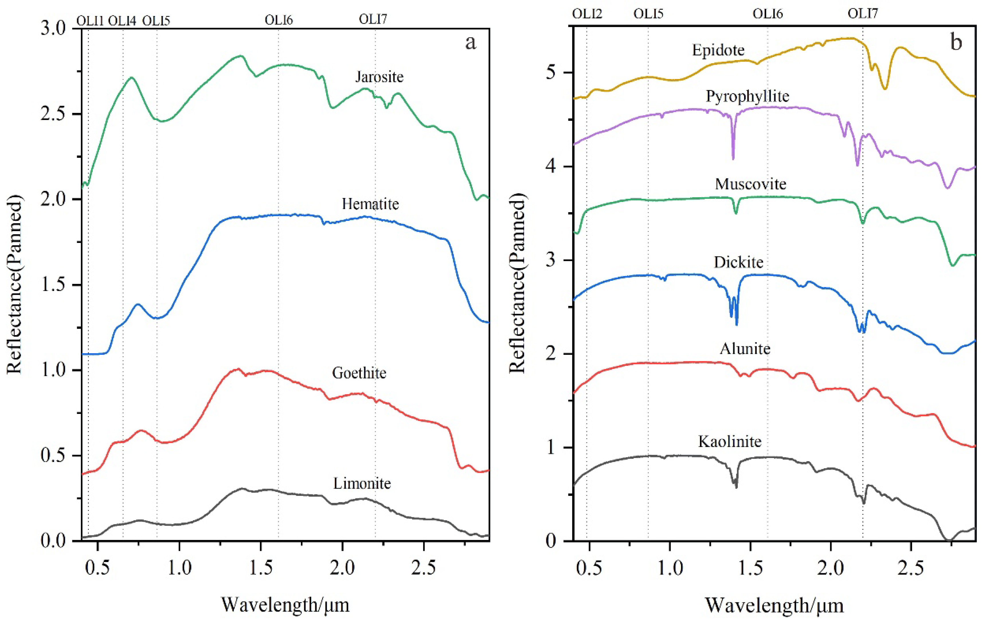
The extraction of alteration information from multispectral images was mainly carried out based on the method of principal component analysis (PCA). PCA usually maps the high-dimensional data to the low-dimensional space via linear transformation, so as to select the most informative and consistent data with the regularity in alteration mineral spectral variation as an eigenvector for the next threshold cutting. PCA has been widely used in the extraction of multispectral iron-stained and oxhydryl alteration mineral information. On the other hand, the rationality of the band selection directly affects the extraction accuracy of the alteration information. Absorption occurs after light irradiates the surface of an object and enters the interior, which is influenced by the internal structure of rocks, trace elements, ions, etc. The electronic jump or vibration of the particles in the objects at different wavelengths corresponds to the diagnostic absorption characteristics on the spectrum curve. The spectral response mechanism of typical alteration minerals in visible–near-infrared and short-wave infrared (VNIR-SWIR) spectra indicates that iron-stained alteration minerals take on some diagnostic features at band1, band4, band5, band6, and band7 (Figure 2a), while the oxhydryl alteration minerals present some diagnostic features at band2, band5, band6, and band7 (Figure 2b). Then, the bands with diagnostic characteristics can be selected for principal component analysis to reduce the redundancy in the data. The corresponding eigenvector results of the principal component analysis are shown in Table 1 and Table 2. The first eigenvector converges the most spatial information from the multispectral image, and the latter component reflects the spectral feature information in the image to the maximum extent. Based on the features in the alteration mineral spectra, PC5 and PC4 were selected for the inversion of iron-stained and oxhydryl alteration mineral information, respectively.

3.2.2. Mineral Identification Based on Hyperspectral

The maximum noise separation transform (MNF) method was used to maximize the separation of useful and noisy signals during the preprocessing stage of the extraction of hyperspectral alteration information, which eliminated the noise components in the images so as to reduce the band dimensions. We defined an image endmember as a spectrum extracted from an image that exhibits the purest spectrum of a material that can be found in the image. Note that this spectrum is likely a “mixed spectrum” containing the target as well as some background material. The bands with strong useful signals were selected to extract pure pixels from the image based on the pure pixel index (PPI) algorithm, retaining as many mineral spectral image endmembers as possible by reducing the threshold detection limitation to ensure the diversity of mineral information extraction (Figure 3). The mixture-tuned matched filtering method is a linear filtering and mapping technique that has been widely applied in the field of alteration information extraction with considerable success [47,48,49]. The principles of MTMF are divided into three main steps: (1) by adjusting the relevant parameters, and with the help of the decomposition model, an abundance inversion of the pixels is carried out based on the image endmembers spectral library; (2) the pixels with different composition ratios are extracted from the abundance map; and (3) the results are presented in the form of grayscale maps. Moreover, an infeasibility image was added to the output results to reduce the false-positive pixels in the matching filtering process by controlling the setting of the pixel abundance threshold with reference to the infeasibility image [50,51]. However, MTMF is still deficient in delineating subclasses of minerals and is therefore not very sensitive to small differences in these minerals.
However, the alteration minerals such as mica can be further classified according to the degree of elemental enrichment into paragonite, muscovite, and phengite. Paragonite tends to form in higher-temperature environments, which can be indicative of the mineralization temperature [52]. Therefore, we introduced a decision tree algorithm on the basis of the above, in which different relationship models were proposed to further classify the mica based on the differences in the concentration of elements in different subclasses of mica, which have characteristic absorptions near 2190 nm, 2200 nm, and 2210~2225 nm, respectively. By virtue of the smaller spectral intervals, GF-5 can distinguish these minerals easily. We selected the corresponding hyperspectral bands based on this characteristic and constructed a decision tree model to achieve the secondary classification of the mica, so as to obtain a finer result.

3.3. Volcanic Crater Interpretation

Craters have long been a point of interest in the field of mineral deposits. However, study-related interpretations of craters based on remote sensing are easily overlooked. Craters are named after the circular hole-like structures created by volcanic eruptions, which are generally circular pits formed by the accumulation of volcanic eruption material around the vents [53,54] (Figure 4a). From the perspective of the mechanism of crater formation, fracture structures provide a direct channel for the upward movement of ore-forming fluid, while the development of the crater provides an indirect channel for magma invasion, which is closely related to mineralization. Craters are usually presented as funnel-shaped, with a topography defined as “low in the middle and high in the surroundings”. Volcanoes with multiple eruptions and eruptive centers may cause more extensive topographic variations—such structures are referred to as calderas. Considering the typical geomorphology of the crater and the difference between its topography and the surrounding terrain, GIS was used for spatial calculation and analysis. ASTER GDEM, a global digital elevation dataset with 30 m spatial resolution, was used in this study, and the data were obtained from the Geospatial Data Cloud. The preprocessing of the elevation data mainly includes data mosaic and cropping functions.
Traditional DEM analysis cannot accurately capture craters, and the attributes of the digital elevation model are mainly elevation values, which often reflect discrete information on the image. Occasionally, the variable contrast within a small area is not obvious. Furthermore, the interference factor by background values is relatively large, which makes it difficult to judge the topographic relief in a small area. The range in elevation within the study area was determined in advance: 4133~6406 m. Generally speaking, to reflect the regional topographic variation, the slope can be back-calculated from the ratio of the difference between the elevation of the summit and the foot of the mountain to the horizontal distance. However, the univariate analysis may have some uncertainties that can be due to interference caused by mountains. Then, in this model, we used “Slope × Elevation” to extend the topographic contrast. In other words, the contrast between crater topography and background values (0~470,364) was extended by multiplying the slope information (0~82°) calculated via the DEM (Figure 4b) to enhance the crater topographic anomaly (Figure 4c). Additionally, craters were further identified based on the color synthesis by using the bands with less correlation of Landsat 8 and Sentinel-1 GRD data. This was combined with the special features of the craters on the image to reduce some of the uncertainties that arise during the crater interpretation process. The geomorphic features of the craters on the corresponding color composite images are more obvious and are usually reflected by the higher gray values in the radar data (Figure 4d).

4. Results

4.1. Alteration Anomaly Extraction

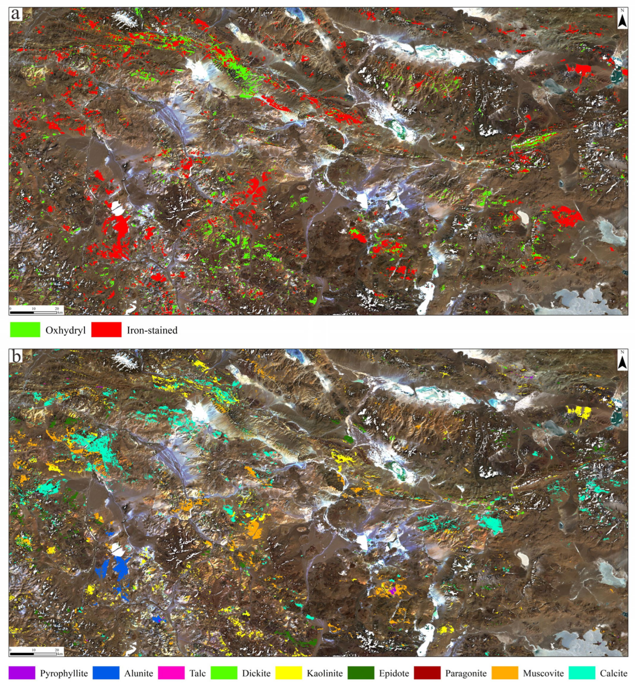
Remote sensing has made certain breakthroughs in the field of geology as an efficient and convenient technology. However, there are numerous studies based on a single multispectral sensor in the field of geological prospecting; this leads to the possibility of significant bias in the extracted results, which is difficult to verify. The extraction of alteration mineral information in this study is based on multisource remote sensing data. Using principal component analysis to enhance the eigenvector of the multispectral images, the abnormal distribution range for iron-stained and oxhydryl alteration was documented. The various data on oxhydryl alteration minerals were further refined by using hyperspectral images. Information was extracted on the distribution of eight alteration minerals: alunite, pyrophyllite, talcite, dickite, epidote, kaolinite, muscovite, and calcite. The extraction information results for the multispectral oxhydryl group minerals and the hyperspectral alteration minerals generally agree (Figure 5a,b), which indicates the validity of the extraction method. The overlapping areas of the multispectral oxhydryl data and the hyperspectral alteration mineral data were used as input together with the areas of iron-stained alteration for the next step in analyzing the remote sensing alteration data.

4.2. Crater Identification Result

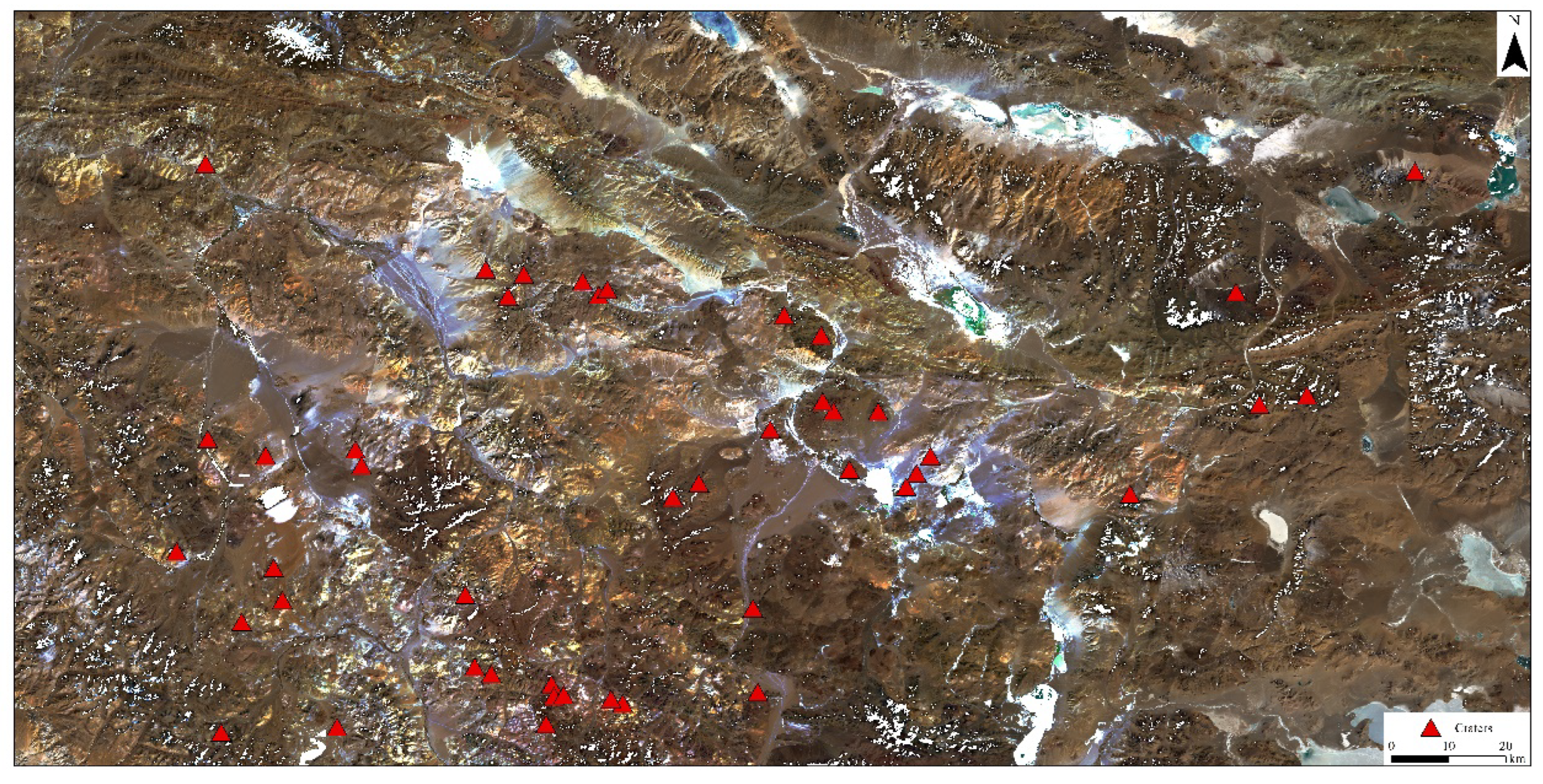
Craters were also identified in this study as another important indicator for predicting mineralization (Figure 6). Combined with the results described above, the analyzed geological data reveal that most of the craters are distributed in the section with stronger magmatic activity, which is basically consistent with the distribution range of some known deposit occurrences. The remote sensing anomalies show that strong rock alteration characterizes most of the interpreted craters, indicating that intense volcanic eruption and magmatic–hydrothermal activity were brought about by subsurface igneous action.

4.3. Geochemical Information Overlay

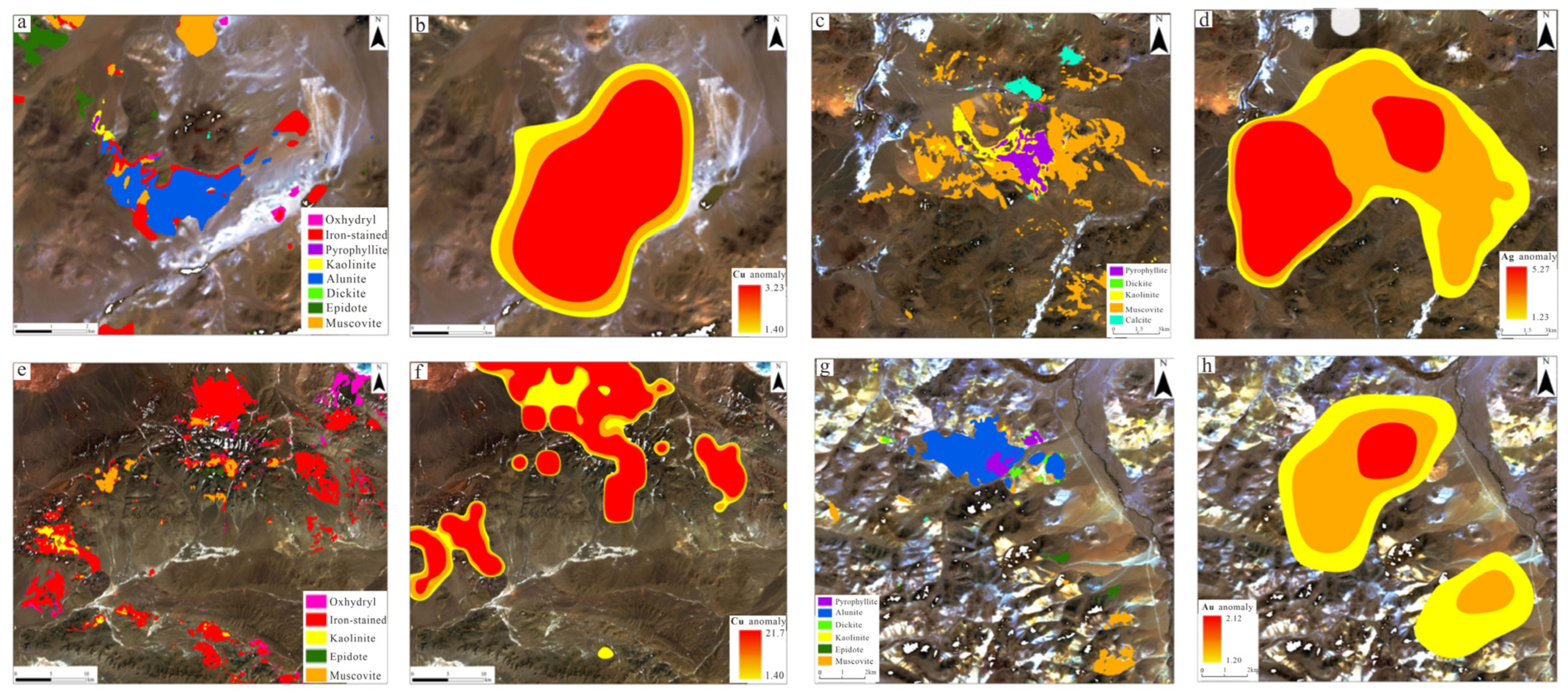
Chemical anomalies often indicate the zones with abnormal contents of relevant elements within the ore body, while the alteration information based on remote sensing data reflects the hydrothermal alteration that occurred during the mineralization process. Then, the 1:500,000 chemical exploration data can be combined and superimposed onto the alteration information extracted from the remote sensing data to achieve a complementary advantage. The results in this stage of validation show that the areal distribution of remote sensing alteration anomaly and metal–chemical anomaly generally correlates, especially consistent with the Cu anomaly overall, followed by the Ag-Au anomaly (Figure 7). These results are also in line with the type of mineralization in the Bangongco-Nujiang belt as a whole.

4.4. Synthesis Anomaly Zone Classification

By intersecting the results of remote sensing alteration information and geochemical anomaly, we overlayed the crater information and the known ore points for synthesis and analysis in order to define the main anomaly areas. For crater-distributed areas where alteration anomaly and geochemical elemental anomaly were intense, we focused on the distribution of known industrial ore spots. Then, based on the development of high-temperature hydrothermal alteration minerals, we categorized the areas into zones.
By analyzing and overlaying the multifaceted information in the ArcGIS 10.2 platform, the anomalous areas in this region are circled and divided into two levels of anomalous zones according to the multifaceted information mentioned above, which can also provide clues for future prospecting in key areas (Figure 8).

5. Discussion

Typical high-sulfur hydrothermal alteration minerals such as alunite and pyrophyllite occur in the area, an observation based on the results extracted from alteration information derived from the remote sensing data. These areas correspond to the advanced argillic alteration zone in shallow-forming, low-temperature, hydrothermal deposits. Some clay minerals such as dickite together with mica, carbonate, and epidote-class minerals correspond to the alteration minerals of the propylitic zone in shallow-forming, low-temperature hydrothermal deposits. Analyzing the data on the type and distribution of alteration minerals based on the remote sensing image data, we infer that the surrounding rocks in the study area are strongly altered, which is consistent with the alteration zone characteristics of typical porphyry–epithermal deposits [55,56,57]. The unique tectonic background in this area dominated by andesite and rhyolite is obviously influenced by collisional orogenics and has a large potential for porphyry and shallow-forming, low-temperature hydrothermal deposits.
As another constraint of mineralization in terrestrial volcanic areas, the distribution of craters and other structures formed by plate convergence usually provides a setting for the occurrence of intermediate products of deposit formation, which is closely related to mineralization [58]. At the same time, the depressions around active volcanic areas often host mineral deposits that are related to volcanic eruptions. The large volume of volcaniclastic rocks formed by the eruptions often protects and preserves the ore body from denudation. Craters have often experienced more complete or multiphase magmatism. Deciphering the volcanic tectonic characteristics of craters in this area facilitates a preliminary understanding of magmatic activity. From analyzing the craters identified in the area, it can be noticed that the craters constrain the intensity of the development of host rock alteration. The high-temperature hydrothermal fluid carried during volcanic eruptions erodes the minerals except quartz and accounts for the formation of alteration minerals of potash feldspar and other minerals [59].
By superimposing the results of alteration mineral information derived from remote sensing onto the geological map and analyzing them with crater information and chemical exploration data, it can be seen that the overall distribution of alteration mineralization trends nearly northwestward, which is consistent with the overall orientation of tectonic fabric, such as large regional fractures. The tectonic fabric often provides channels for circulating hydrothermal fluids that form a sequence of rock alteration minerals within the surrounding rocks. The lithologic alteration within the mineralized zones is consistent with the trend in tectonic fabric, such as regional fractures. The multispectral and hyperspectral images are in good agreement, and the large area of alteration minerals produced via argillization indicates a strong alteration in the surrounding rocks.
Some high-temperature alteration minerals such as alunite and pyrophyllite reflect a favorable mineralization environment, including the temperature and pH of the mineralizing hydrothermal fluid in the study area. Metal anomalies related to chemical prospecting were superimposed on the previous data. Then, the areas with a high correlation between chemical prospecting anomalies and multisource alteration information were intersected and analyzed to identify areas with high prospecting potential. Based on the comprehensive analysis of multiple technical information sources, the terrestrial volcanic rock exhibits zones with suitable geological conditions for mineralization, and the surrounding rock alteration develops with obvious chemical anomalies, which has a significant potential for the formation of ore deposits. Combined with the alteration in the surrounding rocks, it is preliminarily inferred that this area is characterized by a set of high-sulfur porphyry and shallow-forming, low-temperature hydrothermal deposits. Furthermore, large areas of carbonate minerals such as calcite occur along the fracture zone; therefore, it can be inferred that the study area is also likely to include skarn deposits and is characterized by the overall development of a typical shallow-forming low-temperature high-sulfur hydrothermal system accompanied by porphyry and skarn deposits.
To further confirm the results, field research of the key anomalous areas was conducted in this study. The extent of iron-stained alteration information and the distribution of large quantities of alunite in the area of a typical lithocap was primarily investigated. The results of the field research show that the distribution of alteration mineral information is basically consistent with the alternation mineral found in the field (Figure 9a). Random sampling validation was carried out on an anomalous area of nearly 12 square kilometers, and 43 sampling points were set to collect samples. The results show that the overall coincidence precision reached 96.8%. Alunite, pyrophyllite, kaolinite, dickite, and muscovite extracted from the images were found in the field. However, some epidote minerals detected using the samples collected in the field were not extracted from the remote sensing images, which requires further investigation in a future study. We speculate that this may be related to the selection of image endmembers and thresholds. Rocks in this region are basically porous under the influence of an acidic environment, and the alteration minerals enter into the rocks by accounting for potash feldspar, which forms the large-scale advanced argillic zones (Figure 9b–d). The range of iron-stained alteration information extracted from the remote sensing data matches well with the large-scale faded zones in the field (Figure 9e,f), and large amounts of hematite and limonite were found in the field (Figure 9g,h).
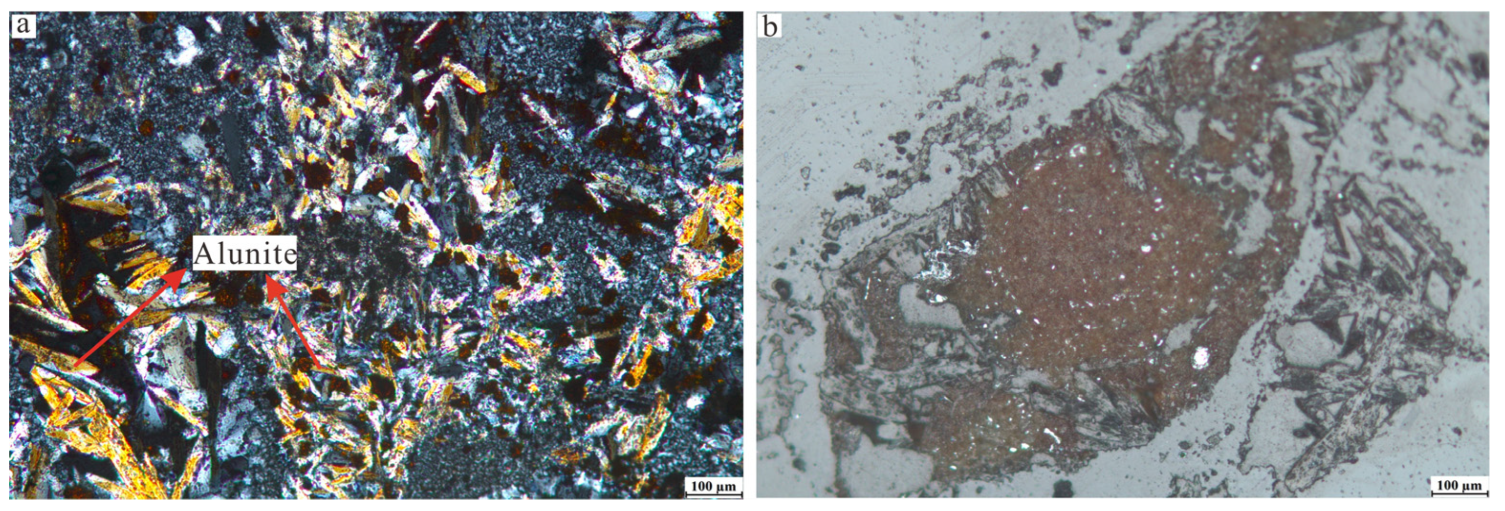
A microscopic experiment was likewise executed so as to observe the microscopic characteristics of the bedrock minerals. Numerous alunites with a more vibrant color were observed under orthogonal polarization, which can be identified as needle-like, yellow-leaf-shaped (Figure 10a). Alunite with this observed characteristic tends to crystallize in hydrothermal environments, indicating a higher temperature. The iron-stained minerals with indicative significance tend to be markedly characterized by reflected light, which usually appears as dark minerals and is dominated by brown and tan (Figure 10b).
These results show the applicability and the potential of remote sensing as a detection method in the field of alteration mineral exploration. However, MTMF is not sufficiently sensitive to distinguish detailed features of some subclasses of minerals, such as short–medium–long wavelength mica, thus limiting this technical method. Although a decision tree was used for further classification, the differentiation between some other subclasses of minerals such as K-alunite and Na-alunite also requires further optimization. In addition, the problem of spatially mixed image elements caused by the spatial resolution of hyperspectral data, together with further detailed field validation, the geochemical elemental characteristics of typical alteration minerals, and the anatomy of alteration lithocaps, are issues that can be addressed in future studies.

6. Conclusions

The mineral research in this study was carried out by combining the extraction of alteration mineral data, the interpretation of crater tectonic information, and chemical exploration records focused on the terrestrial volcanic area west of Gangdise. The distribution and pattern of typical iron-stained and oxhydryl-group alteration minerals (alunite, pyrophyllite, kaolinite, dickite, epidote, muscovite, and calcite) were successfully extracted using multisource remote sensing technology. A regional image endmember spectral library was established during this process. Using “RS + GIS” to identify the crater structure in the area and ascertaining the interpretation mark of craters established an in-depth understanding of magma activity. By superimposing this information with the geological structure, remote sensing, and chemical exploration data, we evaluated the mineralization potential of the terrestrial volcanic rocks zone, defined the mineralization anomaly, and carried out field verification, thus providing an approach for detection of mineralization zones in mountainous areas for future direction in mineralization research and ore deposit exploration.

Author Contributions

Conceptualization, L.B. and J.D.; methodology, L.B.; software, L.B. and Y.S.; validation, L.B., C.W. and N.W.; formal analysis, Z.L. and W.C.; investigation, L.B. and Z.L.; data curation, L.B. and Y.S.; writing—review and editing, L.B. and J.D.; supervision, L.B. and W.C.; funding acquisition, J.D. All authors have read and agreed to the published version of the manuscript.

Funding

This research was funded by the National Key Research and Development Program of China (2022YFC2905001), the China Geological Survey Project (DD20230054, DD20230033), and the National Natural Science Foundation of China (42172332).

Data Availability Statement

The data that were used are confidential.

Acknowledgments

The authors would like to thank the editors and reviewers, who provided constructive comments and suggestions, with special thanks to the data support provided by the Geocloud (geocloud.cgs.gov.cn/) and Geospatial Data Cloud website (https://www.gscloud.cn/). The data used in research was accessed on 14 March 2023.

Conflicts of Interest

The authors declare no conflict of interest.

References

  1. Zhang, X.X.; Tang, J.X.; Lin, B.; Wang, Q.; He, L.; Yan, G.; Shao, R.; Wu, Q.; Du, Q.; Zhaxi, P.C. Geochemistry of magnetite from the Mamupu Cu polymetallic deposit, Yulong belt, Tibet: Implications for magnetite genesis, stages and mechanism of formation. Ore Geol. Rev. 2023, 154, 105334. [Google Scholar]
  2. Song, Y.; Tang, J.X.; Qu, X.M.; Wang, D.H.; Xin, H.B.; Yang, C.; Lin, B.; Fan, S.F. Progress in the Study of Mineralization in the Bangongco-Nujiang Metallogenic Belt and Some New Recognition. Adv. Earth Sci. 2014, 29, 795–809. [Google Scholar]
  3. Yin, A.; Harrison, T.M. Geologic evolution of the Himalayan-Tibetan orogen. Annu. Rev. Earth Planet. Sci. 2000, 28, 211–280. [Google Scholar] [CrossRef]
  4. Plumlee, G.S. The environmental geology of mineral deposits. Soc. Econ. Geol. Rev. Econ. Geol. 1999, 6A, 71–116. [Google Scholar]
  5. Hedenquist, J.W.; Lowenstern, J.B. The role of magmas in the formation of hydrothermal ore deposits. Nature 1994, 370, 519–527. [Google Scholar] [CrossRef]
  6. Fang, X.; Tang, J.X.; Song, Y.; Beaudoin, G.; Yang, C.; Huang, X.W. Genesis of the Shangxu orogenic gold deposit, Bangong-Nujiang suture belt, central Tibet, China: Constraints from H, O, C, Si, He and Ar isotopes. Ore Geol. Rev. 2020, 127, 103810. [Google Scholar] [CrossRef]
  7. Li, G.M.; Qin, K.Z.; Li, J.X.; Evans, N.J.; Zhao, J.X.; Cao, M.J.; Zhang, X.N. Cretaceous magmatism and metallogeny in the Bangong–Nujiang metallogenic belt, central Tibet: Evidence from petrogeochemistry, zircon U–Pb ages, and Hf–O isotopic compositions. Gondwana Res. 2017, 41, 110–127. [Google Scholar] [CrossRef]
  8. Song, Y.; Yang, H.H.; Lin, B.; Liu, Z.B.; Wang, Q.; Gao, K.; Yang, C.; Fang, X. The preservation system of epithermal deposits in South Qiangtang terrane of central Tibetan Plateau and its significance: A case study of the tiegelongnan superlarge deposit. Acta Geosci. Sin. 2017, 38, 659–669. [Google Scholar]
  9. Sillitoe, R.H. Porphyry Copper Systems. Econo Geol. 2010, 105, 3–41. [Google Scholar] [CrossRef]
  10. Kapp, P.; Murphy, M.A.; Yin, A.; Harrison, T.M.; Ding, L.; Guo, J.R. Mesozoic and cenozoic tectonic evolution of the shiquanhe area of Western Tibet. Tectonics 2003, 22, 1029. [Google Scholar] [CrossRef]
  11. Oggier, F.; Widiwijayanti, C.; Costa, F. Global volcanic rock classification of Holocene volcanoes. Sci. Data 2023, 10, 422. [Google Scholar] [CrossRef] [PubMed]
  12. Zhang, S.H.; Ji, W.Q.; Chen, H.B.; Kirstein, L.A.; Wu, F.Y. Linking rapid eruption of the Linzizong volcanic rocks and Early Eocene Climatic Optimum (EECO): Constraints from the Pana Formation in the Linzhou and Pangduo basins, southern Tibet. Lithos 2023, 446, 107159. [Google Scholar] [CrossRef]
  13. Goudge, T.A.; Milliken, R.E.; Head, J.W.; Mustard, J.F.; Fassett, C.I. Sedimentological evidence for a deltaic origin of the western fan deposit in Jezero crater, Mars and implications for future exploration. Earth Planet. Sci. Lett. 2017, 458, 357–365. [Google Scholar] [CrossRef]
  14. Bryan, S.E.; Peate, I.U.; Peate, D.W.; Self, S.; Jerram, D.A.; Mawby, A.R.; Marsh, J.S.; Miller, J.A. The largest volcanic eruptions on Earth. Earth-Sci. Rev. 2010, 102, 207–229. [Google Scholar] [CrossRef]
  15. Sillitoe, R.H.; Hedenquist, J.W. Linkages between volcanotectonic settings, ore-fluid compositions, and epithermal precious metal deposits. Soc. Econ. Geol. Spec. Publ. 2003, 10, 1–29. [Google Scholar]
  16. Basilevsky, A.T.; Head, J.W. Venus: Analysis of the degree of impact crater deposit degradation and assessment of its use for dating geological units and features. J. Geophys. Res. Planets 2002, 107, 5-1–5-38. [Google Scholar] [CrossRef]
  17. Tang, J.X.; Wang, Q.; Yang, H.H.; Gao, X.; Zhang, Z.B.; Zou, B. Mineralization, Exploration and Resource Potential of Porphyry-skarn-epithermal Copper Polymetallic Deposits in Tibet. Acta Geosci. Sin. 2017, 38, 571–613. [Google Scholar]
  18. Chen, W.; Song, Y.; Liu, Q.P.; Zhang, J.Z.; Sun, M.; Song, Z.Z.; Liu, T.F.; Wang, Q.; Yu, J.J.; Li, Y.; et al. Discovery and significance of Xinlong gold deposit in southern margin of Bangonghu-Nujiang metallogenic belt. Miner. Depos. 2022, 41, 1245–1257. [Google Scholar]
  19. Zheng, Y.Y.; Ci, Q.; Gao, S.B.; Wu, S.; Jiang, X.J.; Chen, X. The Ag-Sn-Cu polymetallic minerogenetic series and prospecting direction in the western Gangdese belt, Tibet. Earth Sci. Front. 2021, 28, 379–402. [Google Scholar]
  20. Castor, S.B.; Henry, C.D. Geology, geochemistry, and origin of volcanic rock-hosted uranium deposits in northwestern Nevada and southeastern Oregon, USA. Ore Geol. Rev. 2000, 16, 1–40. [Google Scholar] [CrossRef]
  21. Hedenquist, J.W.; Arribas, R.A.; Gonzalez, U.E. Exploration for epithermal gold deposits. Rev. Econ. Geol. 2000, 13, 245–277. [Google Scholar]
  22. Xu, W.; Li, C.; Wang, M.; Fan, J.J.; Wu, H.; Li, X. Suduction of a spreading ridge within the Bangong Co-Nujiang Tethys Ocean: Evidence from Early Cretaceous mafic dykes in the Duolong porphyry Cu-Au deposit, western Tibet. Gondwana Res. 2017, 41, 128–141. [Google Scholar] [CrossRef]
  23. Lin, B.; Zhang, X.G.; Tang, P.; Wang, L.Q.; Santosh, M.; Xi, Z.; Zhang, X.X.; Qi, J.; He, L. Geology and geochronology of the jinmuguo Mo polymetallic deposit: Implications for the metallogeny of the bangongco-Nujiang belt of Tibet. Ore Geol. Rev. 2021, 139, 104460. [Google Scholar] [CrossRef]
  24. Abdolmaleki, M.; Tabaei, M.; Fathianpour, N.; Gorte, B.G.H. Selecting Optimum Base Wavelet for Extracting Spectral Alteration Features Associated with Porphyry Copper Mineralization Using Hyperspectral Images. Int. J. Appl. Earth Obs. Geoinf. 2017, 58, 134–144. [Google Scholar] [CrossRef]
  25. Herrmann, W.; Blake, M.; Doyle, M.; Huston, D.; Kamprad, J.; Merry, N.; Pontual, S. Short wavelength infrared (SWIR) spectral analysis of hydrothermal alteration zones associated with base metal sulfide deposits at Rosebery and Western Tharsis, Tasmania and Highway Reward, Queensland. Econ. Geol. 2001, 96, 939–955. [Google Scholar] [CrossRef]
  26. Fu, M.H.; Dai, J.J.; Wang, X.G.; Hu, Z.H.; Peng, B.; Wan, X.; Zhang, Z.X.; Zhao, L.X. A study on the Thermal Infrared Spectroscopy Characteristic of the Skarn Minerals in Zhuxi Tungsten Deposit, Jiangxi Province. Spectrosc. Spectr. Anal. 2023, 43, 70–77. [Google Scholar]
  27. Kopylov, I.S.; Kovin, O.N.; Konoplev, A.V. Forecasting of geodynamic hazards at potash mines using remote sensing data: Acase study of the Tubegatan deposit, Uzbekistan. Int. Multidiscip. Sci. GeoConference SGEM 2015, 3, 305. [Google Scholar]
  28. Pour, A.B.; Hashim, M. The application of ASTER remote sensing data to porphyry copper and epithermal gold deposits. Ore Geol. Rev. 2012, 44, 1–9. [Google Scholar] [CrossRef]
  29. Dai, J.J. Application of PALSAR and RADARSAT2 Quad-Polar Data to Study of Geological Structure. Geol. Prospect. 2011, 47, 719–725. [Google Scholar]
  30. Cheng, J.W.; Liu, X.X.; Zhang, J.; Wang, Y.X.; Lu, K.X.; Wang, M. Alternation and Mineralization Characteristics of the Duobuza Porphyry Cu-Au Deposit in Tibet Based on Infrared Spectroscopy Technology: An Example of the Drill Hole ZK3112. Geol. Explor. 2023, 59, 259–270. [Google Scholar]
  31. Yang, X.; Chen, J.; Chen, Z. Classification of Alteration Zones Based on Drill Core Hyperspectral Data Using Semi-Supervised Adversarial Autoencoder: A Case Study in Pulang Porphyry Copper Deposit, China. Remote Sens. 2023, 15, 1059. [Google Scholar] [CrossRef]
  32. Yang, K.; Huntington, J.F.; Gemmell, J.B.; Scott, K.M. Variations in composition and abundance of white mica in the hydrothermal alteration system at Hellyer, Tasmania, as revealed by infrared reflectance spectroscopy. J. Geochem. Explor. 2011, 108, 143–156. [Google Scholar] [CrossRef]
  33. Lobo, A.; Garcia, E.; Barroso, G.; Martí, D.; Fernandez-Turiel, J.-L.; Ibáñez-Insa, J. Machine Learning for Mineral Identification and Ore Estimation from Hyperspectral Imagery in Tin–Tungsten Deposits: Simulation under Indoor Conditions. Remote Sens. 2021, 13, 3258. [Google Scholar] [CrossRef]
  34. Kruse, F.A. Integrated visible and near-infrared, shortwave infrared, and longwave infrared full-range hyperspectral data analysis for geologic mapping. J. Appl. Remote Sens. 2015, 9, 1–17. [Google Scholar] [CrossRef]
  35. Abbaszadeh, M.; Hezarkhani, A.; Soltani-Mohammadi, S. An SVM-based machine learning method for the separation of alteration zones in Sungun porphyry copper deposit. Geochemistry 2013, 73, 545–554. [Google Scholar] [CrossRef]
  36. De La Rosa, R.; Tolosana-Delgado, R.; Kirsch, M.; Gloaguen, R. Automated Multi-Scale and Multivariate Geological Logging from Drill-Core Hyperspectral Data. Remote Sens. 2022, 14, 2676. [Google Scholar] [CrossRef]
  37. Dai, J.J.; Wang, D.H.; Dai, H.Z.; Liu, L.J.; Wu, Y.N. Geological mapping and ore-prospecting study using remote sensing technology in Jiajika area of Western Sichuan Province. Geol. China 2017, 44, 389–398. [Google Scholar]
  38. Zadeh, M.H.; Tangestani, M.H.; Roldan, F.V.; Yusta, I. Mineral Exploration and Alteration Zone Mapping Using Mixture Tuned Matched Filtering Approach on ASTER Data at the Central Part of Dehaj-Sarduiyeh Copper Belt, SE Iran. IEEE J. Sel. Top. Appl. Earth Obs. Remote Sens. 2014, 7, 284–289. [Google Scholar] [CrossRef]
  39. Azizi, H.; Tarverdi, M.A.; Akbarpour, A. Extraction of hydrothermal alterations from ASTER SWIR data from east Zanjan, northern Iran. Adv. Space Res. 2010, 46, 99–109. [Google Scholar] [CrossRef]
  40. Hu, P.Y.; Zhai, Q.G.; Jahn, B.M.; Wang, J.; Li, C.; Chung, S.L.; Lee, H.Y.; Tang, S.H. Late Early Cretaceous magmatic rocks (118–113 Ma) in the middle segment of the Bangong–Nujiang suture zone, Tibetan Plateau: Evidence of lithospheric delamination. Gondwana Res. 2017, 44, 116–138. [Google Scholar] [CrossRef]
  41. Song, Y.; Tang, J.; Lin, B.; Yang, C.; Sun, H. Metallogeny in the Bangong-Nujiang belt, central Tibet, China: A review. Front. Earth Sci. 2023, 11, 1139941. [Google Scholar] [CrossRef]
  42. Ingall, M. Reconstructing carbonate alteration histories in orogenic sedimentary basins: Xigaze forearc, southern Tibet. Geochim. Et. Cosmochim. Acta 2019, 251, 284–300. [Google Scholar] [CrossRef]
  43. Yan, Q.S.; Zhang, Z.P.; Wang, H.T.; Cao, Y.G.; Bao, G.Z. Volcanic Facies and Volcanic Mechanism of Dianzhong Formation of Linzizong Group in Zedang Area, Southern Margin of Gangdese. Acta Geol. Gansu 2022, 31, 13–23. [Google Scholar]
  44. Dong, G.C.; Mo, X.X.; Zhao, Z.D.; Wang, L.; Zhou, S. A new understanding of the stratigraphic successions of the Linzizong volcanic rocks in the Lhunzhub basin, northern Lhasa, Tibet, China. Geol. Bull. China 2005, 24, 549–557. [Google Scholar]
  45. Fernandes, F.; Rasol, M.; Schirinzi, G.; Zhou, F. Editorial for the Special Issue “Radar Techniques for Structures Characterization and Monitoring”. Remote Sens. 2023, 15, 3382. [Google Scholar] [CrossRef]
  46. Abd El-Wahed, M.; Kamh, S.; Abu Anbar, M.; Zoheir, B.; Hamdy, M.; Abdeldayem, A.; Lebda, E.M.; Attia, M. Multisensor Satellite Data and Field Studies for Unravelling the Structural Evolution and Gold Metallogeny of the Gerf Ophiolitic Nappe, Eastern Desert, Egypt. Remote Sens. 2023, 15, 1974. [Google Scholar] [CrossRef]
  47. Siddiqui, A.; Chauhan, P.; Kumar, V.; Jain, G.; Deshmukh, A.; Kumar, P. Characterization of urban materials in AVIRIS-NG data using a mixture tuned matched filtering (MTMF) approach. Geocarto Int. 2022, 37, 332–347. [Google Scholar] [CrossRef]
  48. Rangzan, K. Compression classification methods (MLC, SAM and SID) to provide the best geologic map and using A Spectral Analysis and MTMF Method for enhancing of alteration zones. Adv. Appl. Geol. 2019, 8, 77–87. [Google Scholar]
  49. Tayebi, M.H.; Tangestani, M.H.; Vincent, R.K. Sub-pixel mapping of iron-bearing minerals using ALI data and MTMF algorithm, Masahim volcano, SE Iran. Arab. J. Geosci. 2015, 8, 3799–3810. [Google Scholar] [CrossRef]
  50. Routh, D.; Seegmiller, L.; Bettigole, C.; Kuhn, C.; Oliver, C.D.; Glick, H.B. Improving the reliability of mixture tuned matched filtering remote sensing classification results using supervised learning algorithms and cross-validation. Remote Sens. 2018, 10, 1675. [Google Scholar] [CrossRef]
  51. Qu, L.; Han, W.; Lin, H.; Zhu, Y.; Zhang, L.P. Estimating vegetation fraction using hyperspectral pixel unmixing method: A case study of a karst area in China. IEEE J. Sel. Top. Appl. Earth Obs. Remote Sens. 2014, 7, 4559–4565. [Google Scholar] [CrossRef]
  52. Bioucas-Dias, J.; Plaza, A.; Camps-Valls, G.; Scheunders, P.; Nasrabadi, N.M.; Chanussot, J. Hyperspectral remote sensing data analysis and future challenges. IEEE Geosci. Remote Sens. Mag. 2013, 1, 6–36. [Google Scholar] [CrossRef]
  53. Martínez-Alonso, S.; Jakosky, B.M.; Mellon, M.T.; Putzig, N.E. A volcanic interpretation of Gusev Crater surface materials from thermophysical, spectral, and morphological evidence. J. Geophys. Res. 2005, 110. [Google Scholar] [CrossRef]
  54. Hörz, F.; Ostertag, R.; Rainey, D.A. Bunte Breccia of the Ries: Continuous deposits of large impact craters. Rev. Geophys. 1983, 21, 1667–1725. [Google Scholar] [CrossRef]
  55. Seltmann, R.; Porter, T.M.; Pirajno, F. Geodynamics and metallogeny of the central Eurasian porphyry and related epithermal mineral systems: A review. J. Asian Earth Sci. 2014, 79, 810–841. [Google Scholar] [CrossRef]
  56. Voudouris, P.C.; Melfos, V.; Spry, P.G.; Kartal, T.; Schleicher, H.; Moritz, R.; Ortelli, M. The Pagoni Rachi/Kirki Cu-Mo±Re±Au deposit, northern Greece: Mineralogical and fluid inclusion constraints on the evolution of a telescoped porphyry-epithermal system. Can. Mineral. 2013, 51, 253–284. [Google Scholar] [CrossRef]
  57. Wenyuan, L.; Cook, N.J.; Ciobanu, C.L.; Yu, L.; Xiaoping, Q.; Yuchuan, C. Mineralogy of tin-sulfides in the Zijinshan porphyry–epithermal system, Fujian Province, China. Ore Geol. Rev. 2016, 72, 682–698. [Google Scholar] [CrossRef]
  58. Nadeau, O.; Stix, J.; Williams-Jones, A.E. Links between arc volcanoes and porphyry-epithermal ore deposits. Geology 2016, 44, 11–14. [Google Scholar] [CrossRef]
  59. Sillitoe, R.H. Epithermal paleosurfaces. Miner. Depos. 2015, 50, 767–793. [Google Scholar] [CrossRef]
Figure 1. Geology of the Bangongco–Nujiang metallogenic belt (modified with permission from Ref. [41]. Copyright 2023 Song, Tang, Lin, Yang, and Sun).
Remotesensing 15 04851 g001
Figure 2. Different bands’ response mechanisms of typical minerals (according to USGS): (a) typical iron-stained alteration mineral spectra; (b) typical oxhydryl alteration mineral spectra.
Remotesensing 15 04851 g002
Figure 3. Image endmember spectrum curves extracted from GF-5 AHSI.
Remotesensing 15 04851 g003
Figure 4. The partial information of crater interpretation: (a) craters on Landsat 8 images based on false color synthesis (OLI7 + OLI4 + OLI2); (b) the slope calculated of crater based on elevation; (c) the result based on multiplication; (d) the crater presents higher reflectivity values in the radar data.
Remotesensing 15 04851 g004
Figure 5. Results of alteration information extraction: (a) multispectral alteration information extraction results; (b) hyperspectral alteration information extraction results.
Remotesensing 15 04851 g005
Figure 6. Results of crater interpretation.
Remotesensing 15 04851 g006
Figure 7. Partialization alteration information and chemical exploration anomaly: (a,c,e,g) alteration anomaly information in the area; (b,f) Cu anomaly in the area; (d) Ag anomaly in the area; (h) Au anomaly in the area.
Remotesensing 15 04851 g007
Figure 8. The results of the categorization of the regional multisource information-integrated anomaly areas using circles: (1) pyrophyllite; (2) alunite; (3) talc; (4) dickite; (5) epidote; (6) kaolinite; (7) muscovite; (8) calcite; (9) the intersection results of multisource mineralized alteration areas and chemical anomaly; (10) Cu ore points; (11) Au ore points; (12) Fe-Cu ore points; (13) Anomalous area II; (14) Anomalous area I.
Remotesensing 15 04851 g008
Figure 9. Field verification: (a) the result of hyperspectral alteration information extraction in the regions validated; (b) potash feldspar not metasomatized in rock; (c,d) the rocks with advanced argillic alteration are predominantly porous; (e) the result of iron-stained alteration extraction in the regions validated; (f) faded zones in the field; (g,h) the region of iron-stained mineralization in the field.
Remotesensing 15 04851 g009
Figure 10. Microscopic mineral characterization: (a) mineral characterization of alunite under orthogonal polarization; (b) characterization of hematite under reflected light.
Remotesensing 15 04851 g010
Table 1. Statistical results of iron-stained minerals with OLI1, 4, 5, 6, and 7.
Eigenvectors0.43~0.45 μm (OLI1)0.64~0.67 μm (OLI4)0.85~0.88 μm
(OLI5)
1.57~1.65 μm
(OLI6)
2.11~2.29 μm
(OLI7)
PC1−0.229980−0.419167−0.486871−0.557026−0.473378
PC2−0.638981−0.468476−0.1731840.4438230.381133
PC3−0.5395930.0276930.748602−0.152697−0.352633
PC4−0.2366940.2442660.002245−0.6585370.671293
PC5−0.4377520.737832−0.4153960.189094−0.235937
Table 2. Statistical results of the oxhydryl minerals with OLI2, 5, 6, and 7.
Eigenvectors0.45~0.51 μm
(OLI2)
0.85~0.88 μm
(OLI5)
1.57~1.65 μm
(OLI6)
2.11~2.29 μm
(OLI7)
PC10.2206020.5263060.6302660.526404
PC20.7197660.479502−0.407723−0.292877
PC30.576713−0.635927−0.0921730.504483
PC4−0.3172920.297787−0.6542400.618562
Disclaimer/Publisher’s Note: The statements, opinions and data contained in all publications are solely those of the individual author(s) and contributor(s) and not of MDPI and/or the editor(s). MDPI and/or the editor(s) disclaim responsibility for any injury to people or property resulting from any ideas, methods, instructions or products referred to in the content.