
Anthropic Constraint Dynamics in European Western Mediterranean Floodplains Related to Floods Events


Abstract
1. Introduction
2. General Settings
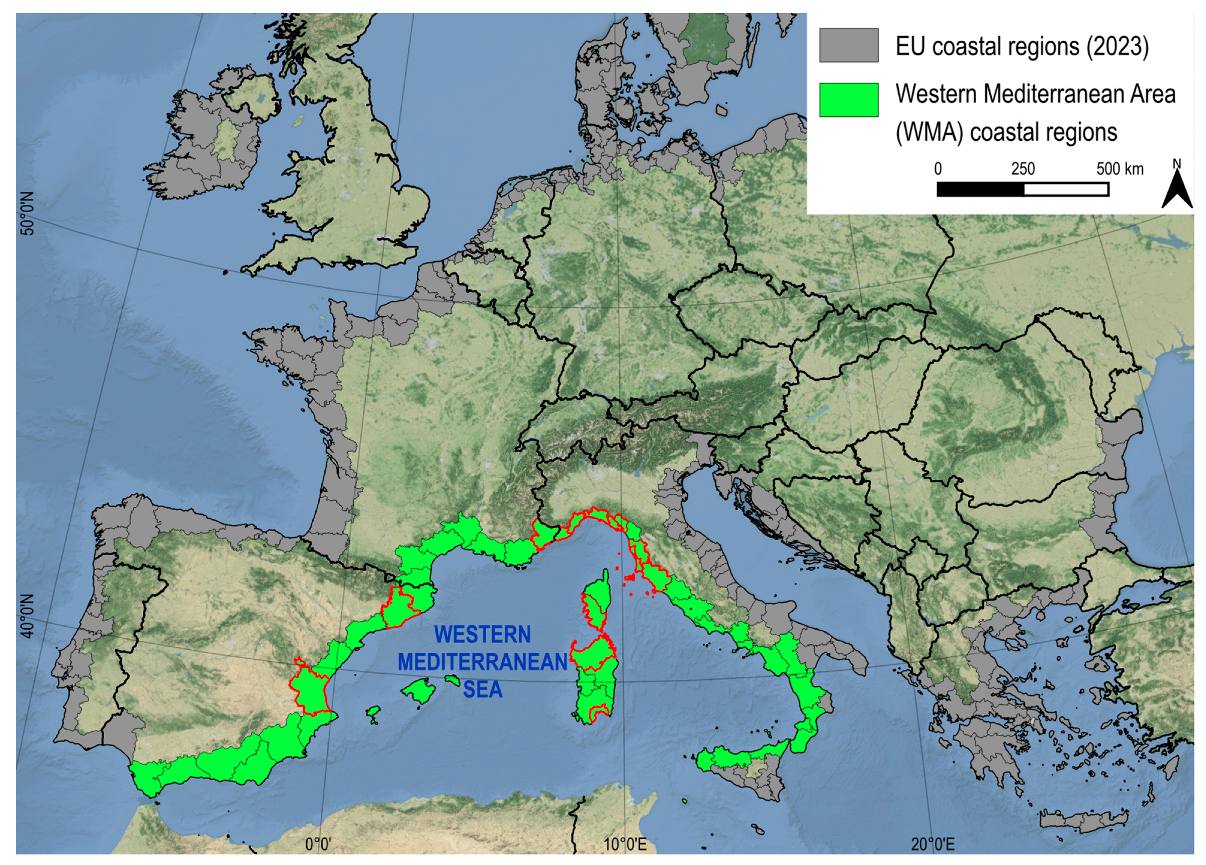
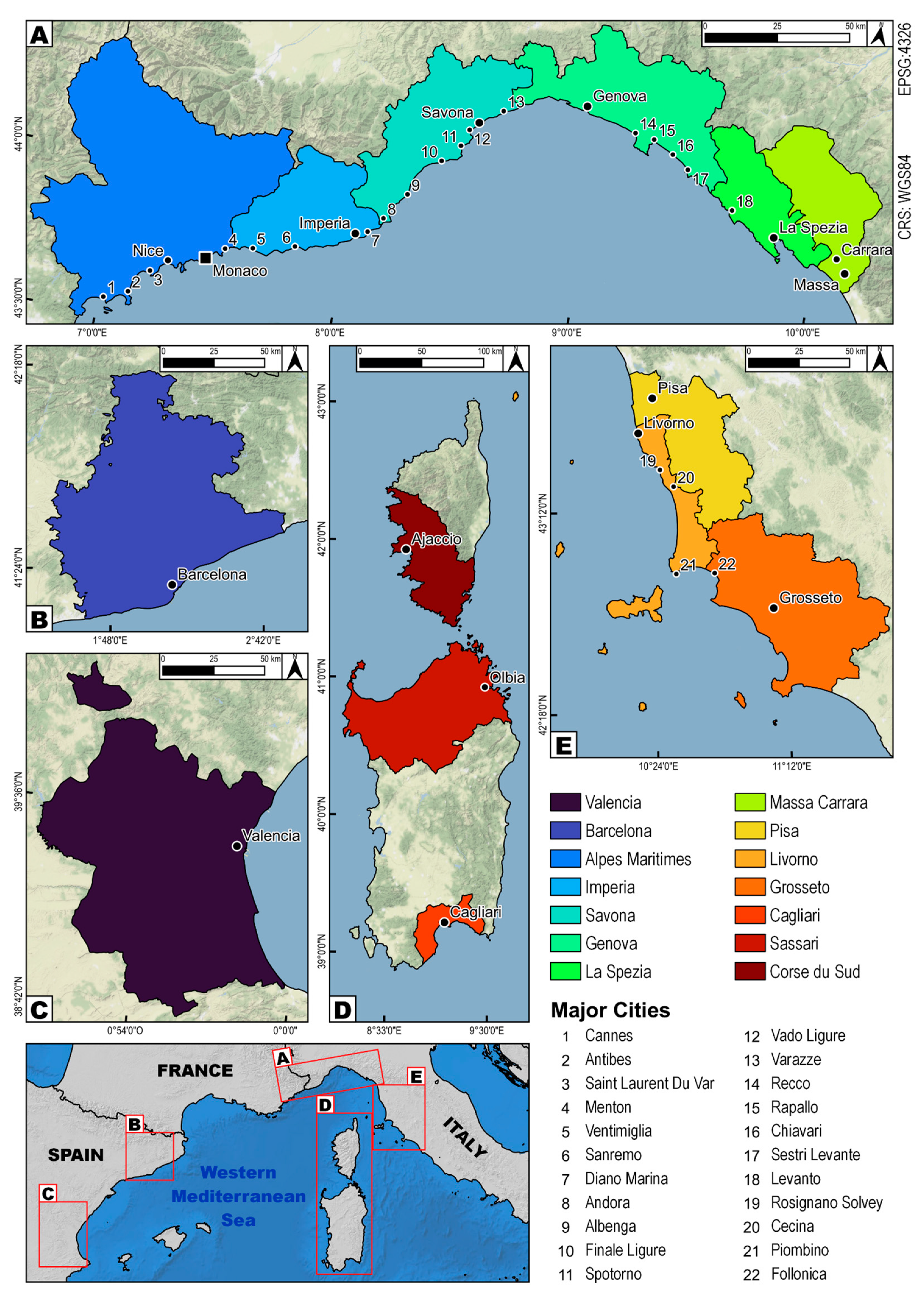
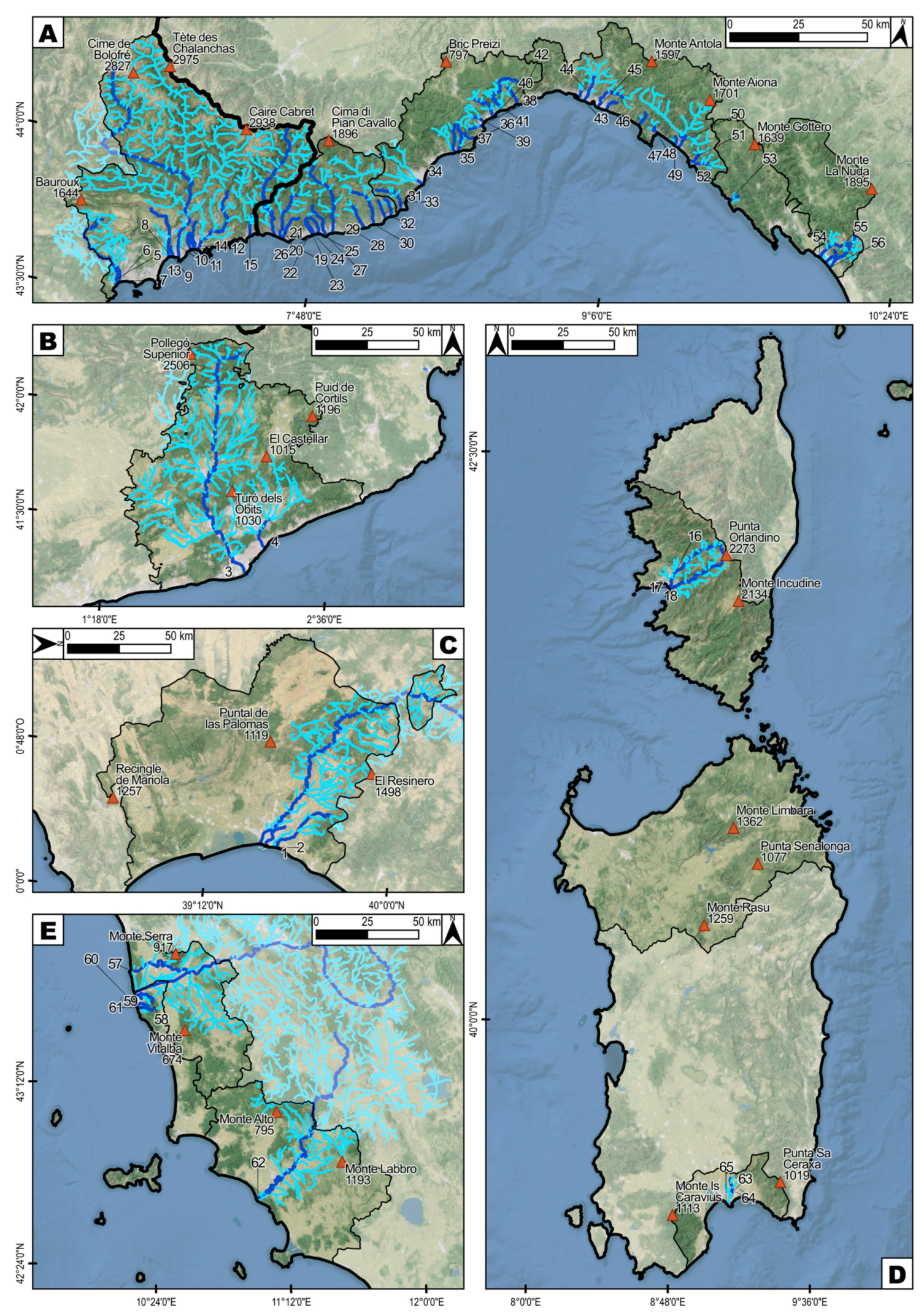
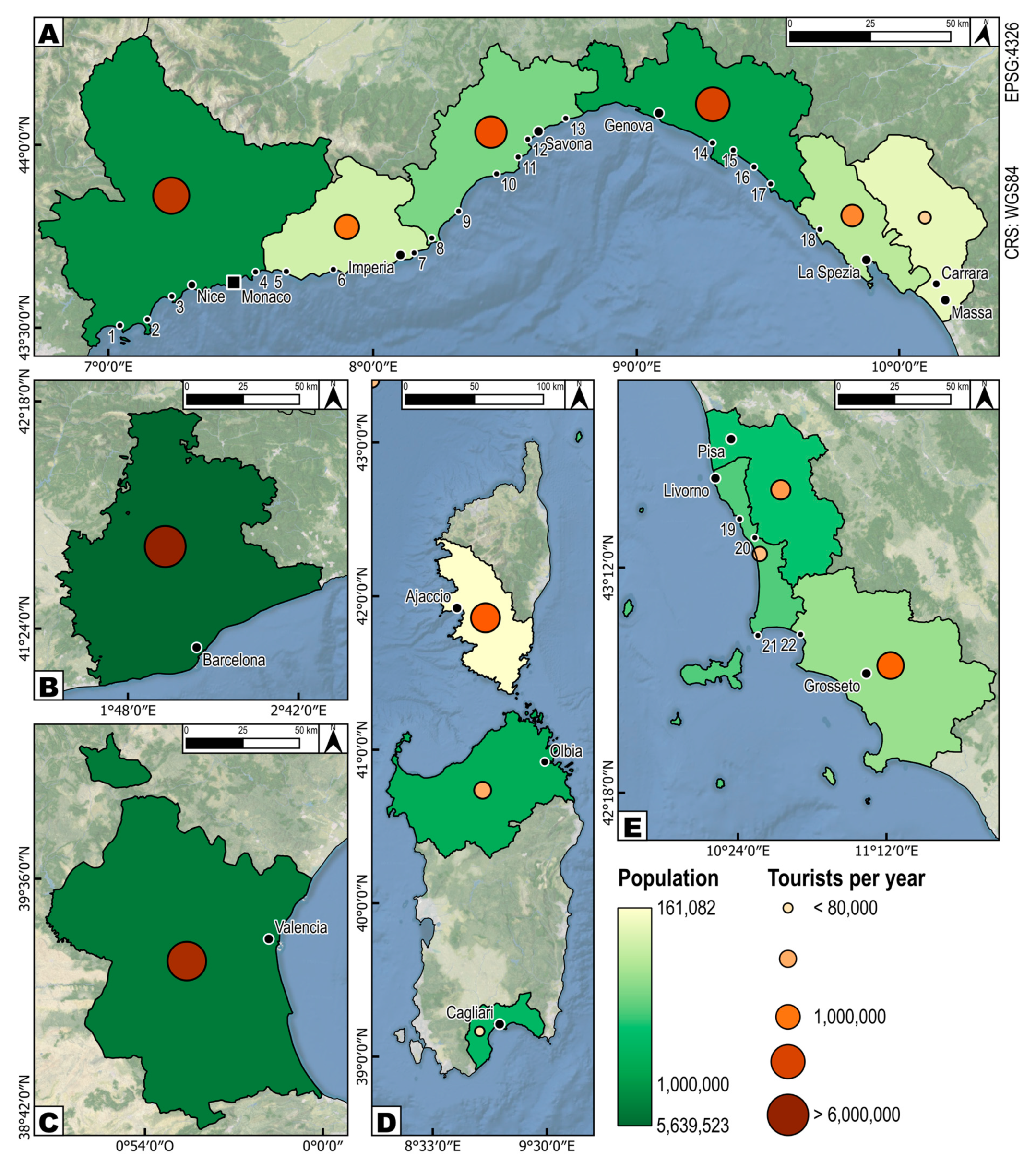
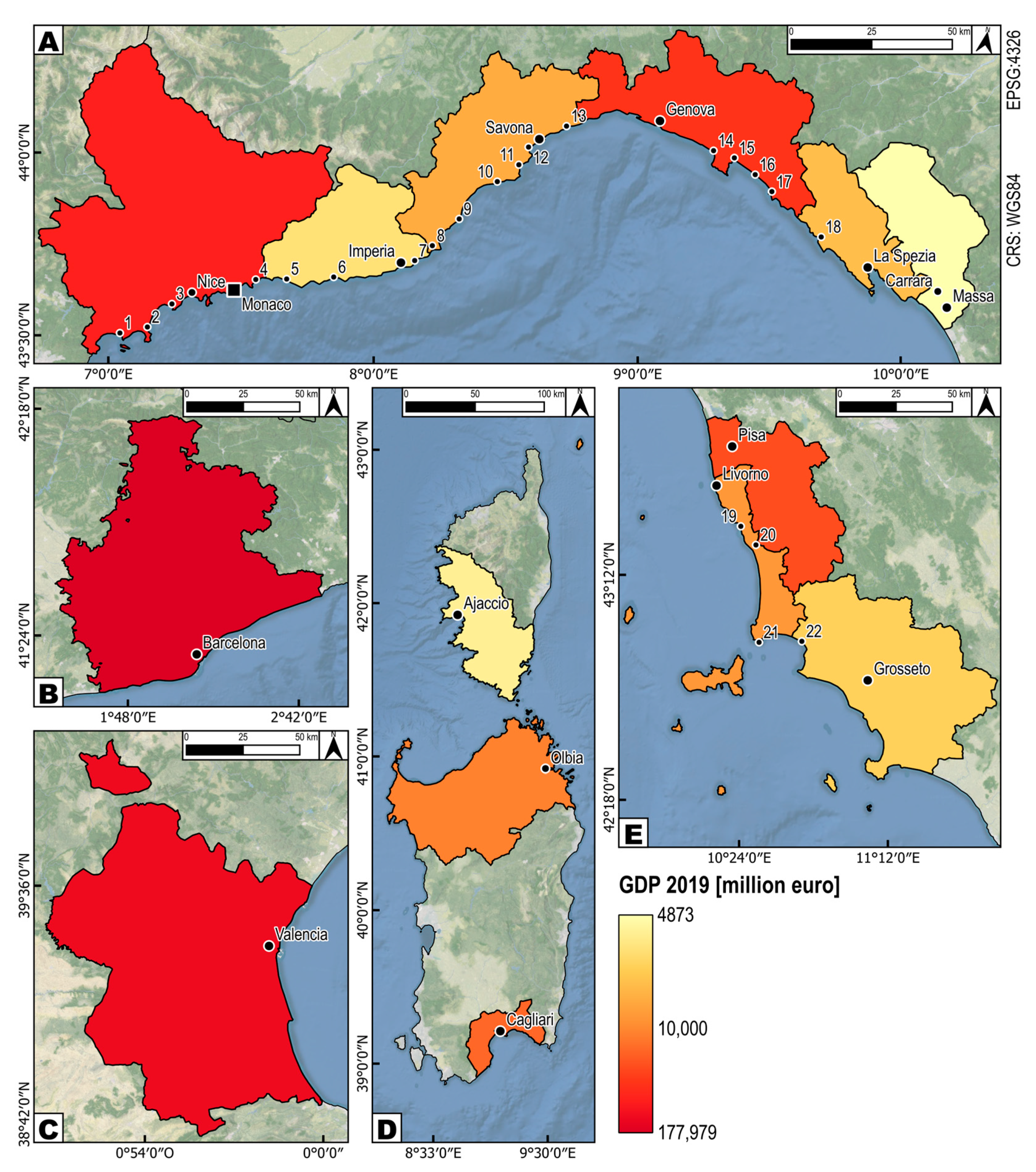
2.1. WMA Coasts
2.2. Population at Risk
3. Materials and Methods
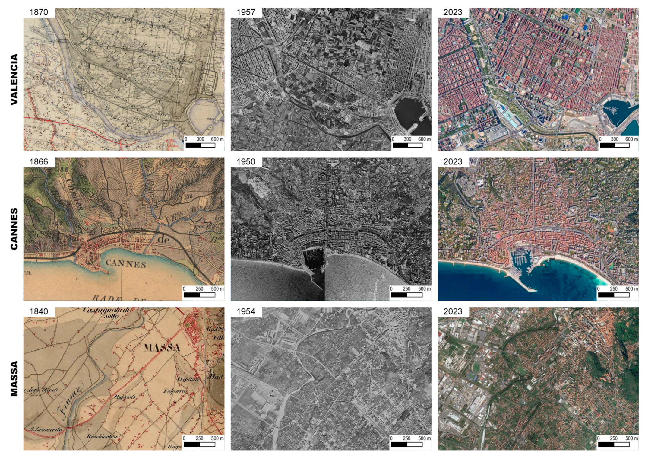
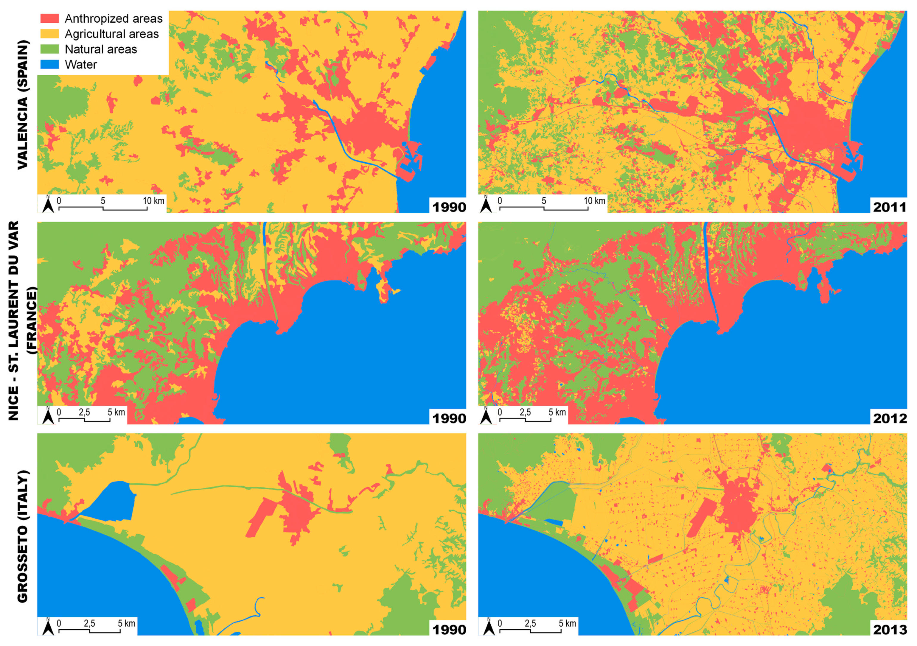
3.1. Urban Impact Analysis
3.2. Hydro-Meteorological Hazards in Study Area


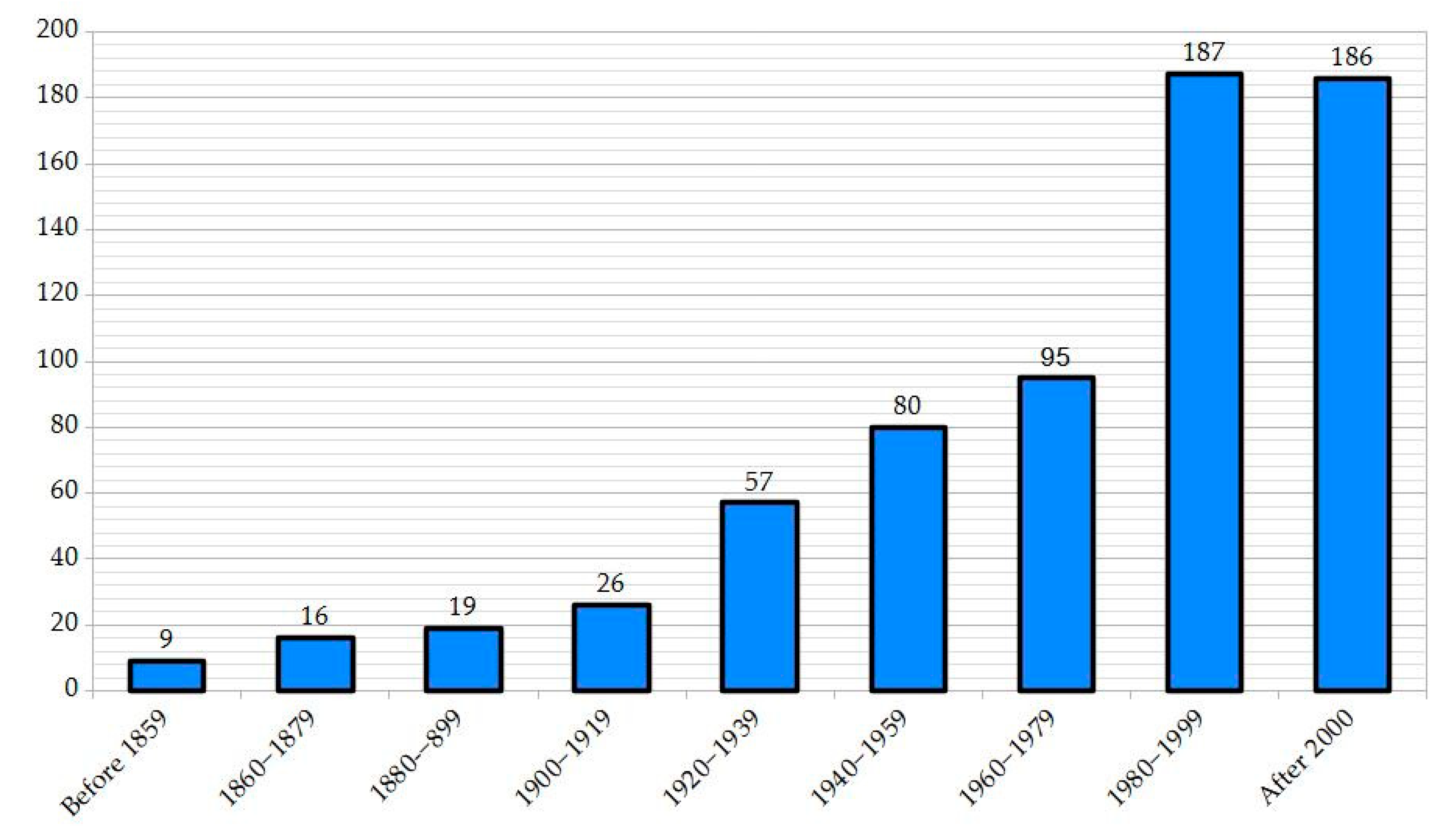
| State | NUTS Name | Total Floods | No. of Victims | Before 1859 | 1860–1879 | 1880–1899 | 1900–1919 | 1920–1939 | 1940–1959 | 1960–1979 | 1980–1999 | After 2000 |
|---|---|---|---|---|---|---|---|---|---|---|---|---|
| ESP | Barcelona | 59 | 446 * | 3 | 5 | 3 | 3 | 3 | 4 | 4 | 11 | 23 |
| Valencia | 33 | 83 | 1 | 3 | 2 | 1 | 0 | 2 | 0 | 7 | 17 | |
| FRA | Alpes Maritt. | 53 | 20 | 0 | 0 | 0 | 0 | 2 | 5 | 2 | 7 | 37 |
| Corse du Sud | 38 | 7 | 0 | 0 | 1 | 0 | 0 | 0 | 1 | 6 | 30 | |
| ITA | Cagliari | 35 | 268 | 1 | 3 | 5 | 0 | 4 | 4 | 3 | 5 | 10 |
| Genova | 54 | 126 | 1 | 1 | 2 | 4 | 4 | 7 | 6 | 12 | 17 | |
| Grosseto | 48 | 12 | 0 | 1 | 0 | 1 | 1 | 6 | 12 | 23 | 4 | |
| Imperia | 45 | 12 | 0 | 0 | 1 | 6 | 1 | 4 | 8 | 16 | 9 | |
| La Spezia | 57 | 11 | 1 | 0 | 1 | 1 | 9 | 8 | 16 | 18 | 3 | |
| Livorno | 62 | 9 | 0 | 0 | 0 | 2 | 4 | 9 | 21 | 20 | 6 | |
| Massa-Carrara | 38 | 6 | 0 | 0 | 0 | 0 | 0 | 4 | 9 | 19 | 6 | |
| Pisa | 35 | 35 | 0 | 1 | 0 | 1 | 1 | 1 | 1 | 22 | 8 | |
| Sassari | 65 | 16 | 0 | 0 | 0 | 3 | 20 | 18 | 6 | 11 | 7 | |
| Savona | 52 | 57 | 2 | 2 | 4 | 4 | 8 | 8 | 6 | 10 | 8 |
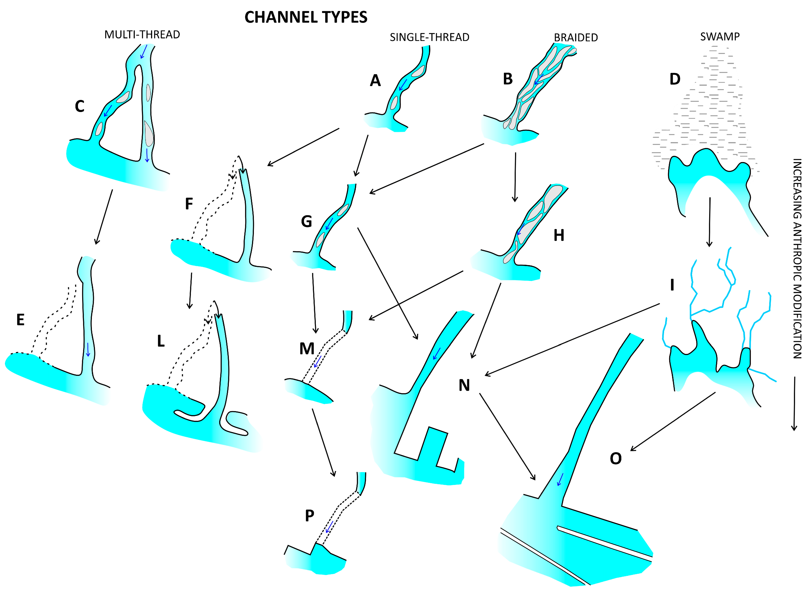
3.3. Riverine Area Morphological Analysis
4. Results
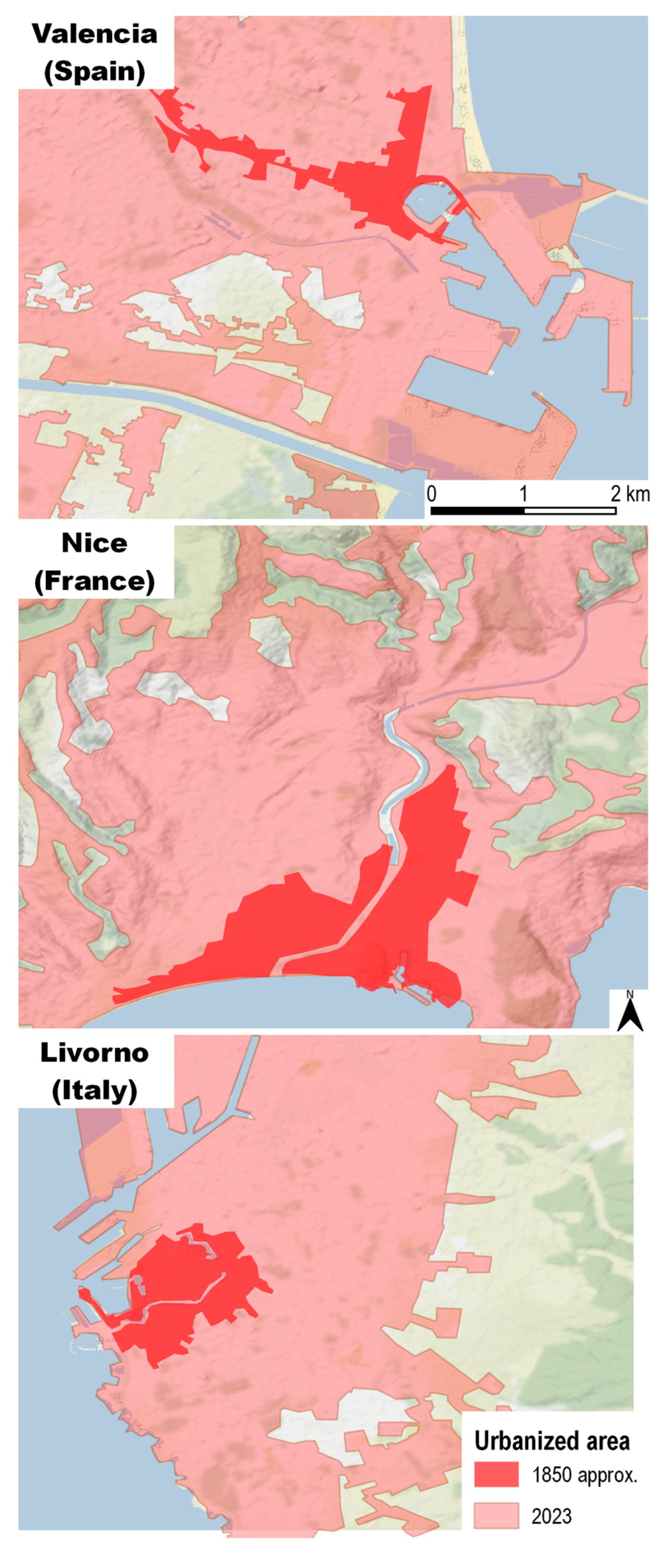
4.1. Urban Sprawl
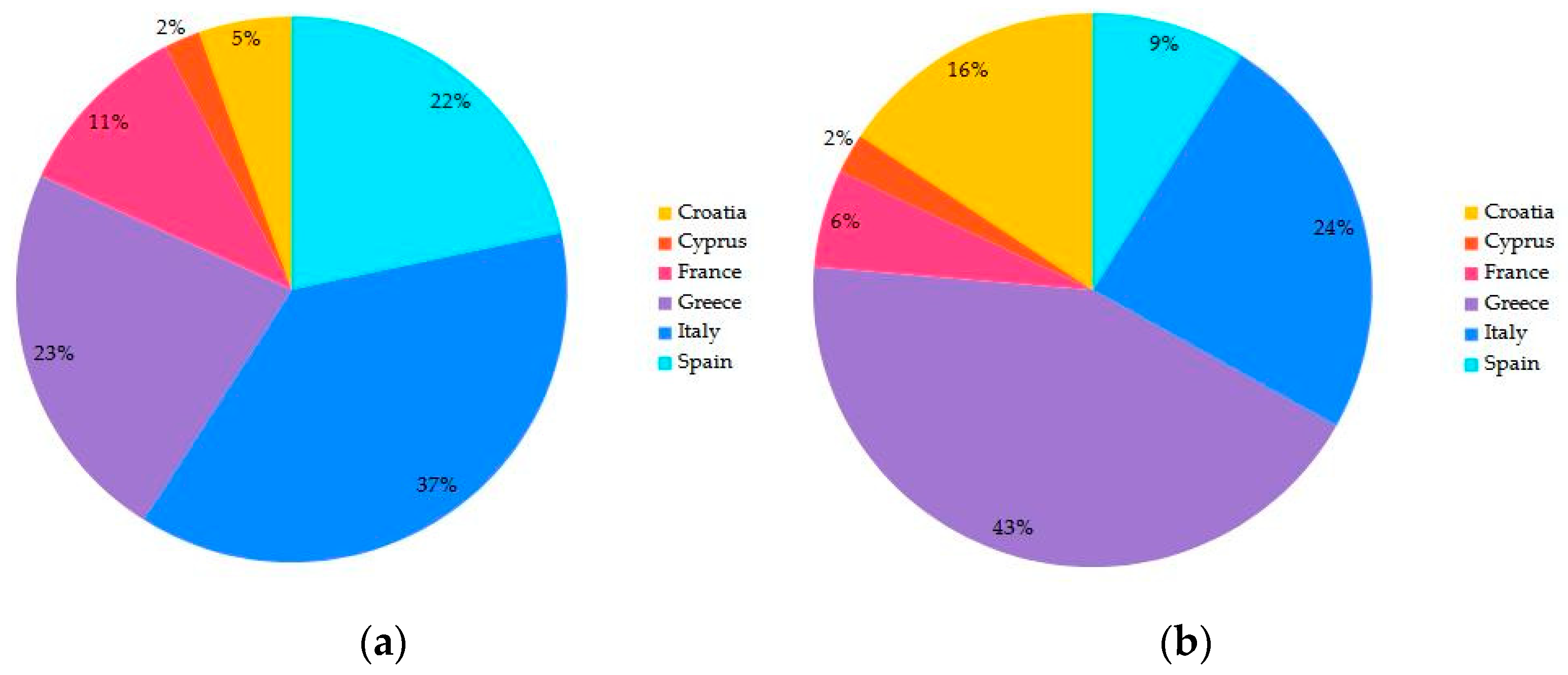
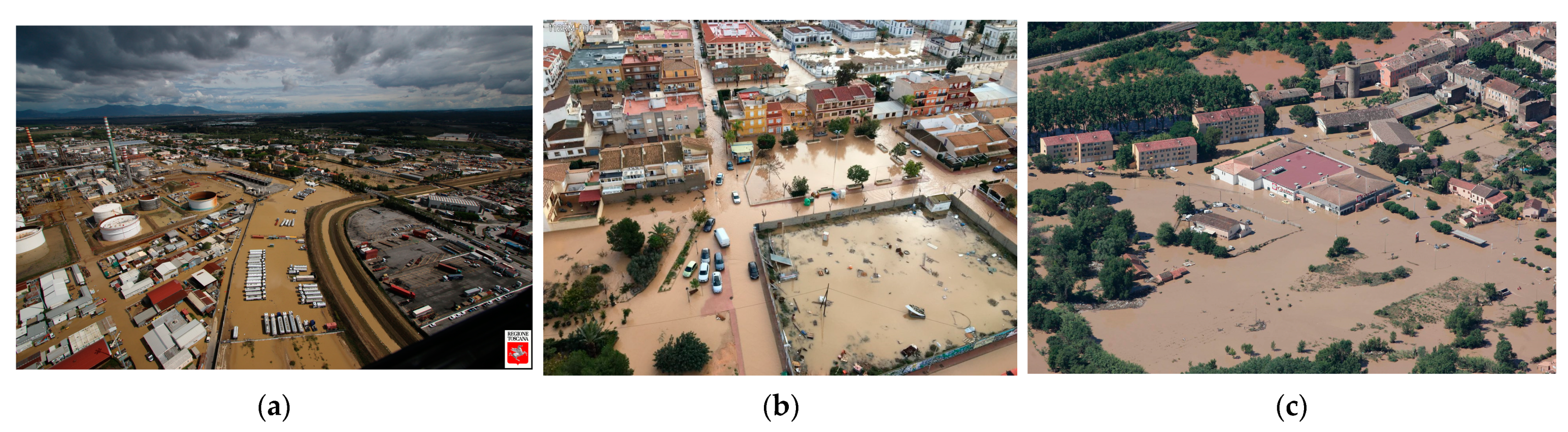
4.2. Hydro-Meteorological Damaging Events
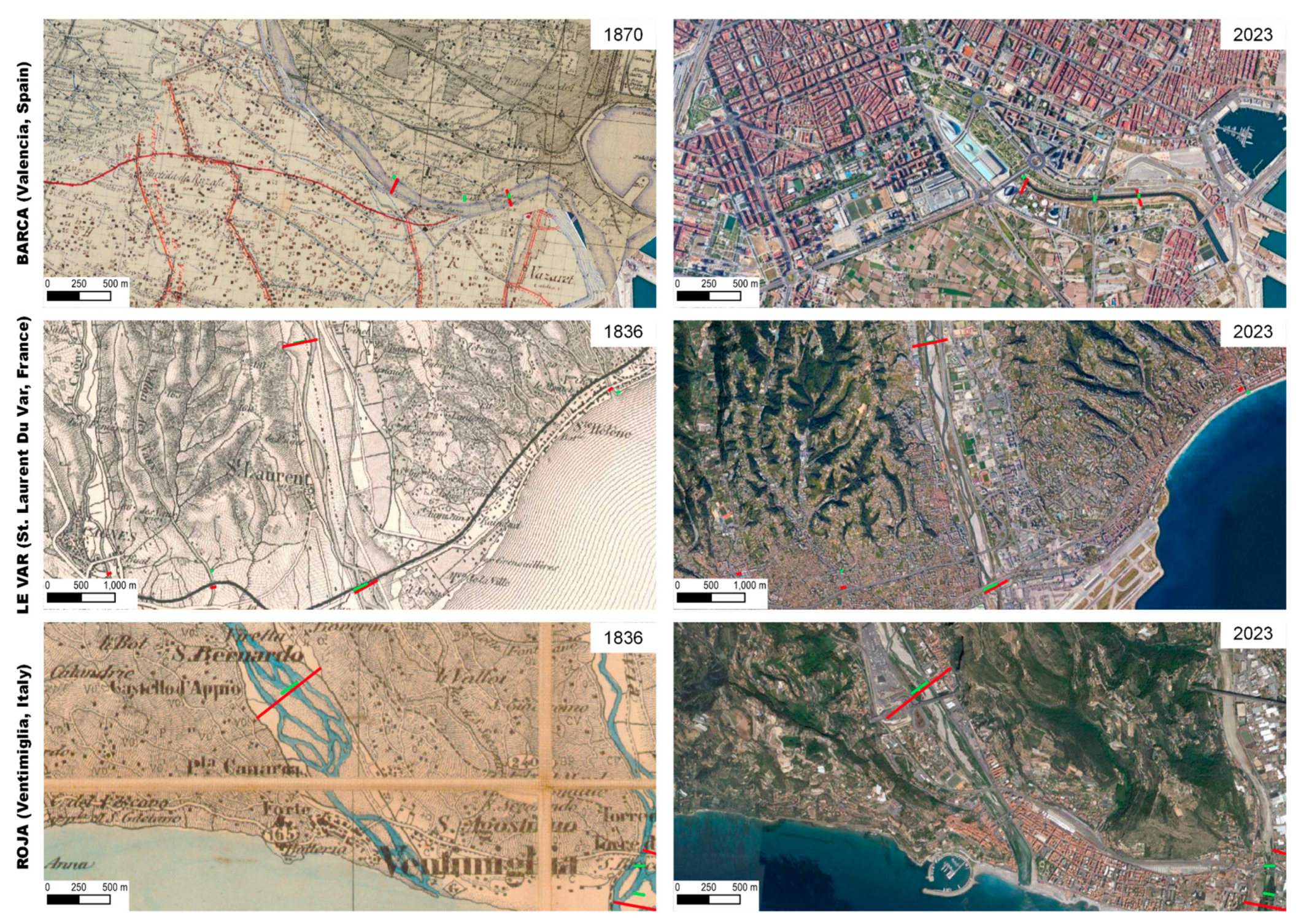
4.3. Riverine Area Transformations
5. Discussion
6. Conclusions
Supplementary Materials
Author Contributions
Funding
Data Availability Statement
Conflicts of Interest
References
- Seneviratne, S.I.; Nicholls, N.; Easterling, D.; Goodess, C.M.; Kanae, S.; Kossin, J.; Luo, Y.; Marengo, J.; McInnes, K.; Rahimi, M.; et al. Changes in Impacts of Climate Extremes and Their Impacts on the Natural Physical Environment. In Managing the Risks of Extreme Events and Disasters to Advance Climate Change Adaptation; Field, C.B., Barros, V., Stocker, T.F., Qin, D., Dokken, D.J., Ebi, K.L., Mastrandrea, M.D., Mach, K.J., Plattner, G.K., Allen, M., et al., Eds.; Cambridge University Press: Cambridge, MA, USA; New York, NY, USA, 2012; pp. 109–230. [Google Scholar] [CrossRef]
- Messmer, M.; Simmonds, I. Global analysis of cyclone-induced compound precipitation and wind extreme events. Weather Clim. Extremes 2021, 32, 100324. [Google Scholar] [CrossRef]
- Oh, S.G.; Son, S.W.; Min, S.K. Possible impact of urbanization on extreme precipitation-temperature relationship in East Asian megacities. Weather Clim. Extremes 2021, 34, 100401. [Google Scholar] [CrossRef]
- Tuel, O.; Martius, A. A climatology of sub-seasonal temporal clustering of extreme precipitation in Switzerland and its impacts. Hydrol. Earth Syst. Sci. 2021, 21, 2949–2972. [Google Scholar] [CrossRef]
- Manandhar, B.; Cui, S.; Wang, L.; Shrestha, S. Post-Flood Resilience Assessment of July 2021 Flood in Western Germany and Henan, China. Land 2023, 12, 625. [Google Scholar] [CrossRef]
- Barton, Y.; Giannakaki, P.; von Waldow, H.; Chevalier, C.; Pfahl, S.; Martius, O. Clustering of Regional-Scale Extreme Precipitation Events in Southern Switzerland. Monthly Weather Rev. 2016, 144, 347–369. [Google Scholar] [CrossRef]
- Ciampa, F.; Seifollahi-Aghmiuni, S.; Kalantari, Z.; Ferreira, C.S.S. Flood Mitigation in Mediterranean Coastal Regions: Problems, Solutions, and Stakeholder Involvement. Sustainability 2021, 13, 10474. [Google Scholar] [CrossRef]
- Pérez, A.; Gil, S.; Olcina, J. Housing bubbles and the increase of flood exposure. Failures in flood risk management on the Spanish south-eastern coast (1975–2013). J. Flood Risk Manag. 2015, 11, 302–311. [Google Scholar] [CrossRef]
- Marijnissen, R.J.C.; Kok, M.; Kroeze, C.; van Loon-Steensma, M.J. Flood risk reduction by parallel flood defences—Case-study of a coastal multifunctional flood protection zone. Coast. Eng. 2021, 167, 103903. [Google Scholar] [CrossRef]
- Gornitz, V.; Oppenheimer, M.; Kopp, R.; Horton, R.; Orton, P.; Rosenzweig, C.; Solecki, W.; Patrick, L. Enhancing New York City’s resilience to sea level rise and increased coastal flooding. Urban Clim. 2020, 33, 100654. [Google Scholar] [CrossRef]
- Morucci, S.; Coraci, E.; Crosato, F.; Ferla, M. Extreme events in Venice and in the North Adriatic Sea: 28–29 October 2018. Rend. Lincei Sci. Fis. Nat. 2020, 31, 113–122. [Google Scholar] [CrossRef]
- Faccini, F. Geohydrological hazards and urban development in the Mediterranean area: An example from Genoa (Ligu-ria, Italy). NHESS 2015, 15, 2631–2652. [Google Scholar] [CrossRef]
- Tamagnone, P.; Massazza, G.; Pezzoli, A.; Rosso, M. Hydrology of the Sirba River: Updating and Analysis of Discharge Time Series. Water 2019, 11, 156. [Google Scholar] [CrossRef]
- Ollero, A. Channel changes and floodplain management in the meandering middle Ebro River, Spain. Geomorphology 2010, 117, 247–260. [Google Scholar] [CrossRef]
- Stein, L.; Pianosi, F.; Woods, R. Event-based classification for global study of river flood generating processes. Hydr. Process. 2020, 34, 1514–1529. [Google Scholar] [CrossRef]
- Blöschl, G.; Hall, J.; Viglione, A.; Perdigão, R.A.P.; Parajka, J.; Merz, B.; Lun, D.; Arheimer, B.; Aronica, G.T.; Bilibashi, A.; et al. Changing climate both increases and decreases European river floods. Nature 2019, 573, 108–111. [Google Scholar] [CrossRef]
- Tramblay, Y.; Mimeau, L.; Neppel, L.; Freddy, V.; Sauquet, E. Detection and attribution of flood trends in Mediterranean basins. Hydr. Earth Syst. Sci. 2019, 23, 4419–4431. [Google Scholar] [CrossRef]
- Lompi, M.; Mediero, L.; Caporali, E. Future Flood Hazard Assessment for the City of Pamplona (Spain) Using an Ensemble of Climate Change Projections. Water 2021, 13, 792. [Google Scholar] [CrossRef]
- Lehmann, J.; Coumou, D.; Frieler, K. Increased record-breaking precipitation events under global warming. Clim. Chang. 2015, 132, 517–518. [Google Scholar] [CrossRef]
- Polomčić, D.; Bajić, D.; Ratković, J. Assessment of Historical Flood Risk to the Groundwater Regime: Case Study of the Kolubara Coal Basin, Serbia. Water 2018, 10, 588. [Google Scholar] [CrossRef]
- Doocy, S.; Daniels, A.; Murray, S.; Kirsch, T.D. The human impact of floods: A historical review of events 1980–2009 and systematic literature review. PLoS Curr. 2013, 16, 5. [Google Scholar] [CrossRef]
- Jacob, D.; Petersen, J.; Eggert, B.; Alias, A.; Christensen, O.B.; Bouwer, L.M.; Braun, A.; Colette, A.; Déqué, M.; Georgievski, G.; et al. EURO-CORDEX: New high-resolution climate change projections for European impact research. In IPCC—Climate Change 2021: The Physical Science Basis. Contribution of Working Group I to the Sixth Assessment Report of the Intergovernmental Panel on Climate Change; Cambridge University Press: Cambridge, UK, 2021; Volume 14, pp. 563–578. [Google Scholar] [CrossRef]
- Stocker, T.F.; Qin, D.; Plattner, G.-K.; Alexander, L.V.; Allen, S.K.; Bindoff, N.L.; Bréon, F.-M.; Church, J.A.; Cubasch, U.; Emori, S.; et al. Technical summary. In Climate Change 2013: The Physical Science Basis. Contribution of Working Group I to the Fifth Assessment Report of the Intergovernmental Panel on Climate Change; Stocker, T.F., Qin, D., Plattner, G.-K., Tignor, M., Allen, S.K., Doschung, J., Nauels, A., Xia, Y., Bex, V., Midgley, P.M., Eds.; Cambridge University Press: Cambridge, UK, 2013; pp. 33–115. [Google Scholar] [CrossRef]
- Cherif, S.; Doblas-Miranda, E.; Lionello, P.; Borrego, C.; Giorgi, F.; Iglesias, A.; Jebari, S.; Mahmoudi, E.; Moriondo, M.; Pringault, O.; et al. Drivers of change. In Climate and Environmental Change in the Mediterranean Basin—Current Situation and Risks for the Future. First Mediterranean Assessment Report; Cramer, W., Guiot, J., Marini, K., Eds.; Union for the Mediterranean: Marseille, France, 2020; pp. 59–180. [Google Scholar]
- Field, C.B.; Barros, V.R.; Dokken, D.J.; Mach, K.J.; Mastrandrea, M.D.; Bilir, T.E. Climate Change 2014: Impacts, Adaptation, and Vulnerability. Part A: Global and Sectoral Aspects. Working Group II Contribution to the Fifth Assessment Report of the Intergovernmental Panel on Climate Change; Cambridge University Press: Cambridge, UK, 2014. [Google Scholar] [CrossRef]
- Hoegh-Guldberg, O.; Jacob, D.; Taylor, M.; Bindi, M.; Brown, S.; Camilloni, I.; Diedhiou, A.; Djalante, R.; Ebi, K.; Engelbrecht, F.; et al. Impacts of 1.5 °C Global Warming on Natural and Human Systems. In Global Warming of 1.5 °C: An IPCC Special Report; Masson-Delmotte, V., Zhai, P., Pörtner, H.O., Roberts, D., Skea, J., Shukla, P.R., Pirani, A., Moufouma-Okia, W., Péan, C., Pidcock, R., et al., Eds.; IPCC Secretariat: Geneva, Switzerland, 2018; pp. 175–311. [Google Scholar]
- Cramer, W.; Guiot, J.; Marini, K. Climate and Environmental Change in the Mediterranean Basin—Current Situation and Risks for the Future; First Mediterranean Assessment Report; MedECC, Union for the Mediterranean: Marseille, France, 2020; 632p, ISBN 978-2-9577416-0-1. [Google Scholar] [CrossRef]
- Kovats, R.S.; Valentini, R.; Bouwer, L.; Georgopoulou, E.; Jacob, D.; Martin, E.; Rounsevell, M.; Soussana, J.-F. Europe. In Climate Change 2014: Impacts, Adaptation, and Vulnerability. Part B: Regional Aspects. Contribution of Working Group II to the Fifth Assessment Report of the Intergovernmental Panel on Climate Change; Pachauri, R.K., Meyer, L.A., Eds.; Cambridge University Press: Cambridge, UK, 2014; pp. 1267–1326. [Google Scholar] [CrossRef]
- Niang, I.; Ruppel, O.C.; Abdrabo, M.A.; Essel, A.; Lennard, C.; Padgham, J.; Urquhart, P. Africa. In Climate Change 2014: Impacts, Adaptation, and Vulnerability. Part B: Regional Aspects. Contribution of Working Group II to the Fifth Assessment Report of the Intergovernmental Panel on Climate Change; Barros, V.R., Field, C.B., Dokken, D.J., Mastrandrea, M.D., Mach, K.J., Eds.; Cambridge University Press: Cambridge, UK, 2014; pp. 1199–1265. [Google Scholar] [CrossRef]
- Nurse, L.A.; Mclean, R.; Agard, J.; Briguglio, L.; Duvat, V.; Pelesikoti, N.; Tompkins, E. Small islands. In Climate Change 2014: Impacts, Adaptation, and Vulnerability. Part B: Regional Aspects. Contribution of Working Group II to the Fifth Assessment Report of the Intergovernmental Panel on Climate Change; Barros, V.R., Field, C.B., Dokken, D.J., Mastrandrea, M.D., Mach, K.J., Bilir, T.E., Chatterjee, M., Ebi, K.L., Estrada, Y.O., Genova, R.C., et al., Eds.; Cambridge University Press: Cambridge, UK, 2014; pp. 1613–1654. [Google Scholar] [CrossRef]
- Pörtner, H.-O.; Karl, D.M.; Boyd, P.W.; Cheung, W.W.L.; Lluch-Cota, S.E.; Nojiri, Y.; Schmidt, D.N.; Zavialov, P.O. Ocean systems. In Climate Change 2014: Impacts, Adaptation, and Vulnerability. Part B: Regional Aspects. Contribution of Working Group II to the Fifth Assessment Report of the Intergovernmental Panel on Climate Change; Field, C.B., Barros, V.R., Dokken, D.J., Mach, K.J., Mastrandrea, M.D., Bilir, T.E., Chatterjee, M., Ebi, K.L., Estrada, Y.O., Genova, R.C., et al., Eds.; Cambridge University Press: Cambridge, UK, 2014; pp. 411–484. [Google Scholar] [CrossRef]
- Pörtner, H.O.; Scholes, R.J.; Agard, J.; Archer, E.; Arneth, A.; Bai, X.; Barnes, D.; Burrows, M.; Chan, L.; Cheung, W.L.; et al. IPBES-IPCC Co-Sponsored Workshop Report on Biodiversity and Climate Change; IPBES and IPCC: Bonn, Germany, 2021; p. 28. [Google Scholar] [CrossRef]
- Poloczanska, E.S.; Brown, C.J.; Sydeman, W.J.; Kiessling, W.; Schoeman, D.S.; Moore, P.J.; Brander, K.; Bruno, J.F.; Buckley, L.B.; Burrows, M.T.; et al. Global imprint of climate change on marine life. Nat. Clim. Chang. 2013, 3, 919–925. [Google Scholar] [CrossRef]
- Balzan, M.V.; Sadula, R.; Scalvenzi, L. Assessing Ecosystem Services Supplied by Agroecosystems in Mediterranean Europe: A Literature Review. Land 2020, 9, 245. [Google Scholar] [CrossRef]
- Mariotti, A.; Pan, Y.; Zeng, N.; Alessandri, A. Long-term climate change in the Mediterranean region in the midst of decadal variability. Clim. Dyn. 2015, 44, 1437–1456. [Google Scholar] [CrossRef]
- Hertig, E.; Tramblay, Y. Regional downscaling of Mediterranean droughts under past and future climatic conditions. Glob. Planet. Chang. 2017, 151, 36–48. [Google Scholar] [CrossRef]
- Lionello, P.; Scarascia, L. The relation of climate extremes with global warming in the Mediterranean region and its north versus south contrast. Reg. Environ. Chang. 2020, 20, 31. [Google Scholar] [CrossRef]
- Llasat, M.C.; Marcos, R.; Turco, M.; Gilabert, J.; Llasat-Botija, M. Trends in flash flood events versus convective precipitation in the Mediterranean region: The case of Catalonia. J. Hydrol. Reg. Stud. 2016, 541, 24–37. [Google Scholar] [CrossRef]
- Tramblay, Y.; Jarlan, L.; Hanich, L.; Somot, S. Future Scenarios of Surface Water Resources Availability in North African Dams. Water Resour. Manag. 2018, 32, 1291–1306. [Google Scholar] [CrossRef]
- Mazzeo, G.; Polverino, S. Nature-based solution for climate change adaptation and mitigation in urban areas with high natural risk. TeMA. J. Land Use Mobility Environ. 2023, 16, 47–65. [Google Scholar] [CrossRef]
- Mediero, L.; Santillán, D.; Garrote, L.; Granados, A. Detection and attribution of trends in magnitude, frequency and timing of floods in Spain. J. Hydrol. 2014, 517, 1072–1088. [Google Scholar] [CrossRef]
- Baahmed, D.; Oudin, L.; Errih, M. Current runoff variations in the Macta catchment (Algeria): Is climate the sole factor? Hydrol. Sci. J. 2015, 60, 1331–1339. [Google Scholar] [CrossRef]
- Gaume, E.; Borga, M.; Llasat, M.C.; Maouche, S.; Lang, M.; Diakakis, M. Mediterranean extreme floods and flash floods. In The Mediterranean Region under Climate Change; Thiébault, S., Moatti, J.P., Eds.; A Scientific Update Coll. Synthèses: Marseille, France, 2016; pp. 133–144. [Google Scholar]
- Paprotny, D.; Sebastian, A.; Morales-Nápoles, O.; Jonkman, S.N. Trends in flood losses in Europe over the past 150 years. Nat. Commun. 2018, 9, 1985. [Google Scholar] [CrossRef] [PubMed]
- Vicente-Serrano, S.M.; Domínguez-Castro, F.; Murphy, C.; Hannaford, J.; Reig, F.; Peña-Angulo, D.; Tramblay, Y.; Trigo, R.M.; Mac Donald, N.; Luna, M.Y.; et al. Long-term variability and trends in meteorological droughts in Western Europe (1851–2018). Int. J. Climatol. 2020, 41, E690–E717. [Google Scholar] [CrossRef]
- Eurostat. Available online: https://ec.europa.eu/ (accessed on 23 January 2022).
- European Environment Agency. Available online: https://www.eea.europa.eu/themes/water/europes-seas-and-coasts (accessed on 15 March 2023).
- Gohar, A.; Kondolf, G.M. Flash flooding as a threat to settlements even in remote areas. Environ. Urban. 2017, 29, 503–514. [Google Scholar] [CrossRef]
- Petrucci, O.; Papagiannaki, K.; Aceto, L.; Boissier, L.; Kotroni, V.; Grimalt, M. MEFF: The database of MEditerranean Flood Fatalities (1980 to 2015). J. Flood Risk Manag. 2019, 12, e12461. [Google Scholar] [CrossRef]
- Del Moral, A.; Llasat, M.C.; Rigo, T. Connecting flash flood events with radar-derived convective storm characteristics on the Northwestern Mediterranean coast: Knowing the present for better future scenarios adaptation. Atmos. Res. 2020, 238, 104863. [Google Scholar] [CrossRef]
- Hafnaoui, M.A.; Madi, M.; Hachemi, A.; Farhi, Y. El Bayadh city against flash floods: Case study. Urban Water J. 2020, 17, 390–395. [Google Scholar] [CrossRef]
- Gaume, E.; Bain, V.; Bernardara, P.; Newinger, O.; Barbuc, M.; Bateman, A.; Blaškovičová, L.; Blöschl, G.; Borga, M.; Dumitrescu, A.; et al. A compilation of data on European flash floods. J. Hydrol. 2009, 367, 70–78. [Google Scholar] [CrossRef]
- Llasat, M.C.; Llasat-Botija, M.; Prat, M.A.; Porcú, F.; Price, C.; Mugnai, A.; Lagouvardos, K.; Kotroni, V.; Katsanos, D.; Michaelides, S. High-impact floods and flash floods in Mediterranean countries: The FLASH preliminary database. Adv. Geosci. 2010, 23, 47–55. [Google Scholar] [CrossRef]
- Senatore, A.; Davolio, S.; Furnari, L.; Mendicino, G. Reconstructing Flood Events in Mediterranean Coastal Areas Using Different Reanalyses and High-Resolution Meteorological Models. J. Hydrometeor. 2020, 21, 1865–1887. [Google Scholar] [CrossRef]
- Faccini, F.; Luino, F.; Paliaga, G.; Roccati, A.; Turconi, L. Flash Flood Events along the West Mediterranean Coasts: Inundations of Urbanized Areas Conditioned by Anthropic Impacts. Land 2021, 10, 620. [Google Scholar] [CrossRef]
- Nouaceur, Z.; Murarescu, O.; Muratoreanu, G. Statistical Analysis of Heavy Rains and Floods around the French Mediterranean Basin over One Half a Century of Observations. Geosciences 2022, 12, 447. [Google Scholar] [CrossRef]
- Vinet, F.; Bigot, V.; Petrucci, O.; Papagiannaki, K.; Llasat, M.C.; Kotroni, V.; Boissier, L.; Aceto, L.; Grimalt, M.; Llasat-Botija, M.; et al. Mapping Flood-Related Mortality in the Mediterranean Basin. Results from the MEFF v2.0 DB. Water 2019, 11, 2196. [Google Scholar] [CrossRef]
- López Díez, A.; Máyer Suárez, P.; Díaz Pacheco, J.; Dorta Antequera, P. Rainfall and Flooding in Coastal Tourist Areas of the Canary Islands (Spain). Atmosphere 2019, 10, 809. [Google Scholar] [CrossRef]
- Roccati, A.; Paliaga, G.; Luino, F.; Faccini, F.; Turconi, L. Rainfall Threshold for Shallow Landslides Initiation and Analysis of Long-Term Rainfall Trends in a Mediterranean Area. Atmosphere 2020, 11, 1367. [Google Scholar] [CrossRef]
- Einfalt, T.; Hatzfeld, F.; Wagner, A.; Seltmann, J.; Castro, D.; Frerichs, S. URBAS: Forecasting and management of flash floods in urban areas. Urban Water J. 2009, 6, 369–374. [Google Scholar] [CrossRef]
- Service Interministériel Régional de Défense et de Protection Civiles (SIRDPC) de la Préfecture de Corse-du-Sud. Available online: https://www.portivechju.corsica/wp-content/uploads/2021/07/DDRM_Corse-du-Sud_2021_2.pdf (accessed on 12 July 2022).
- Accuweather. Available online: www.https://www.accuweather.com/en/severe-weather/deadly-flooding-wreaks-havoc-in-france-italy-and-greece/634338 (accessed on 4 July 2022).
- Luino, F.; Paliaga, G.; Roccati, A.; Sacchini, A.; Turconi, L.; Faccini, F. Anthropogenic changes in the alluvial plains of the Tyrrhenian Ligurian basins. Rend. Online Soc. Geol. Ital. 2019, 48, 10–16. [Google Scholar] [CrossRef]
- Silvestro, F.; Rebora, N.; Rossi, L.; Dolia, D.; Gabellani, S.; Pignone, F.; Trasforini, E.; Rudari, R.; De Angeli, S.; Masciulli, C. What if the 25 October 2011 event that struck Cinque Terre (Liguria) had happened in Genoa, Italy? Flooding scenarios, hazard mapping and damage estimation. Nat. Hazards Earth Syst. Sci. 2016, 16, 1737–1753. [Google Scholar] [CrossRef]
- Faccini, F.; Luino, F.; Sacchini, A.; Turconi, L. The 4th October 2010 flash flood event in Genoa Sestri Ponente (Liguria, Italy). Disaster Adv. 2015, 8, 1–14. [Google Scholar] [CrossRef]
- Roccati, A.; Faccini, F.; Luino, F.; De Graff, J.; Turconi, L. Morphological changes and human impact in the Entella River floodplain (Northern Italy) from the 17th century. Catena 2019, 182, 104122. [Google Scholar] [CrossRef]
- Audisio, C.; Turconi, L. Urban floods: A case study in the Savigliano area (North-Western Italy). Nat. Hazards Earth Syst. Sci. 2011, 11, 2951–2964. [Google Scholar] [CrossRef]
- Vietz, G.J.; Walsh, C.J.; Fletche, T.D. Urban hydrogeomorphology and the urban stream syndrome: Treating the symptoms and causes of geomorphic change. Prog. Phys. Geogr. 2016, 40, 480–492. [Google Scholar] [CrossRef]
- Cutter, S.L.; Emrich, C.T.; Gall, M.; Reeves, R. Flash Flood Risk and the Paradox of Urban Development. Nat. Hazards Rev. 2018, 19, 05017005. [Google Scholar] [CrossRef]
- Ertan, S.; Çelik, R.N. The Assessment of Urbanization Effect and Sustainable Drainage Solutions on Flood Hazard by GIS. Sustainability 2021, 13, 2293. [Google Scholar] [CrossRef]
- Paliaga, G.; Faccini, F.; Luino, F.; Turconi, L. A spatial multicriteria prioritizing approach for geohydrological risk mitigation planning in small and densely urbanized Mediterranean basins. Nat. Hazards Earth Syst. Sci. 2019, 19, 53–69. [Google Scholar] [CrossRef]
- Roccati, A.; Luino, F.; Turconi, L.; Piana, P.; Watkins, C.; Faccini, F. Historical Geomorphological Research of a Ligurian Coastal Floodplain (Italy) and Its Value for Management of Flood Risk and Environmental Sustainability. Sustainability 2018, 10, 3727. [Google Scholar] [CrossRef]
- Cassola, F.; Ferrari, F.; Mazzino, A.; Miglietta, M.M. The role of the sea on the flash floods events over Liguria (northwestern Italy). Geophys. Res. Lett. 2016, 43, 3534–3542. [Google Scholar] [CrossRef]
- Nimbus Hydrological Events. La Piena del Torrenta Genova del 26 Novembre 2002. Available online: http://www.nimbus.it/eventi/2002/021126genova.htm (accessed on 16 May 2022).
- Faccini, F.; Luino, F.; Paliaga, G.; Sacchini, A.; Turconi, L.; Dejong, C. Role of rainfall intensity and urban sprawl in the 2014 flash flood in Genoa City, Bisagno catchment (Liguria, Italy). Appl. Geogr. 2018, 98, 224–241. [Google Scholar] [CrossRef]
- Cevasco, A.; Brandolini, P.; Scopesi, C.; Rellini, I. Relationships between geo-hydrological processes induced by heavy rainfall and land-use: The case of 25 October 2011 in the Vernazza catchment (Cinque Terre, NW Italy). J. Maps 2013, 9, 289–298. [Google Scholar] [CrossRef]
- The 4th October 2021 Event. Available online: https://www.greenlifeblog.it/2021/10/05/le-piogge-eccezionali-di-lunedi-4-ottobre-2021-in-liguria-e-piemonte/ (accessed on 23 May 2022).
- Mandarino, A.; Luino, F.; Faccini, F. Flood-induced ground effects and flood-water dynamics for hydro-geomorphic hazard assessment: The 21–22 October 2019 extreme flood along the lower Orba River (Alessandria, NW Italy). J. Maps 2021, 17, 1–16. [Google Scholar] [CrossRef]
- ISPRA 2023. Available online: https://www.isprambiente.gov.it/files2023/notizie/nota-22maggio.pdf (accessed on 6 July 2023).
- ARPAE 2023. Available online: https://www.arpae.it/it/notizie/levento-meteo-idrogeologico-del-1-4-maggio (accessed on 8 July 2023).
- Flaounas, S.; Fita, L.; Lagouvardos, K.; Kotroni, V. Heavy rainfall in Mediterranean cyclones, Part II: Water budget, precipitation efficiency and remote water sources. Climate Dyn. 2019, 53, 2539–2555. [Google Scholar] [CrossRef]
- Dottori, F.; Alfieri, L.; Bianchi, A.; Skoien, J.; Salamon, P. A new dataset of river flood hazard maps for Europe and the Mediterranean Basin. Earth Syst. Sci. Data 2022, 14, 1549–1569. [Google Scholar] [CrossRef]
- European Office for Statistics. Available online: https://ec.europa.eu/eurostat (accessed on 4 July 2022).
- Ministero dell’Ambiente, Geoportale Nazionale. Available online: http://www.pcn.minambiente.it/mattm/ (accessed on 15 April 2022).
- COPERNICUS, Land Monitoring Service. Available online: https://land.copernicus.eu/ (accessed on 5 December 2022).
- Regione Autonoma della Sardegna. Available online: www.sardegnageoportale.it (accessed on 12 January 2023).
- IGN. Catalogue Remonter le Temps. Available online: https://geoservices.ign.fr/remonter-le-temps (accessed on 7 July 2022).
- Regione Toscana. Available online: www.regione.toscana.it/-/geoscopio (accessed on 24 June 2022).
- Gobierno de España, Instituto Geográfico Nacional. Available online: https://www.ign.es/web/ign/portal (accessed on 5 August 2022).
- Arcanum Maps. Available online: https://maps.arcanum.com/en/ (accessed on 7 May 2022).
- Regione Liguria. Available online: https://geoportal.regione.liguria.it/ (accessed on 20 June 2022).
- Website 6 Aprile, Sardegna. Available online: http://www.6aprile.it/featured/2013/11/19/cronistoria-delle-alluvioni-in-sardegna.html (accessed on 18 January 2022).
- AEMET Spain’s State Meteorological Agency. Available online: https://floodlist.com/europe/spain-murcia-floods-september-2022 (accessed on 5 January 2023).
- Météo-France. Available online: http://pluiesextremes.meteo.fr/france-metropole/Catastrophe-sur-la-Cote-d-Azur.html (accessed on 7 January 2023).
- Kougkoulos, I.; Merad, M.; Cook, S.J.; Andredakis, I. Floods in Provence-Alpes-Côte d’Azur and lessons for French flood risk governance. Nat Hazards 2021, 109, 1959–1980. [Google Scholar] [CrossRef]
- Carrega, P. Les inondations azuréennes du 3 octobre 2015: Un lourd bilan lié à un risque composite. Pollut Atmosphérique 2016, 228, 1–26. [Google Scholar] [CrossRef]
- Anthony, E.J.; Marriner, N.; Morhange, C. Human influence and the changing geomorphology of Mediterranean deltas and coasts over the last 6000 years: From progradation to destruction phase? Earth-Sci. Rev. 2014, 139, 336–361. [Google Scholar] [CrossRef]
- Surian, N.; Rinaldi, M. Morphological response to river engineering and management in alluvial channels in Italy. Geomorphology 2003, 50, 307–326. [Google Scholar] [CrossRef]
- Camarasa-Belmonte, A.M.; Soriano-Garcia, J. Flood risk assessment and mapping in peri-urban Mediterranean environments using hydrogeomorphology. Application to ephemeral streams in the Valencia region (eastern Spain). Landsc. Urban Plan. 2012, 104, 189–200. [Google Scholar] [CrossRef]
- Brandolini, P.; Faccini, F.; Paliaga, G.; Piana, P. Urban Geomorphology in Coastal Environment: Man-Made Morphological Changes in a Seaside Tourist Resort (Rapallo, Eastern Liguria, Italy). Quaest. Geogr. 2017, 36, 97–110. [Google Scholar] [CrossRef]
- Barriendos, M.; Rodrigo, F.S. Study of historical flood events on Spanish rivers using documentary data. Hydrol. Sci. J. 2006, 51, 765–783. [Google Scholar] [CrossRef]
- MEDEC Climate and Environmental Change in the Mediterranean Basin—Current Situation and Risks for the Future. Available online: https://www.medecc.org/wp-content/uploads/2020/11/MedECC_MAR1_3_1_Water.pdf (accessed on 5 June 2022).
- First Mediterranean Assessment Report (MAR1) Gobierno de España, Dirección General de Protección Civil y Emergencias. Available online: https://www.proteccioncivil.es/ (accessed on 5 November 2022).
- Sardegna Clima APS. Available online: https://sardegna-clima.it/ (accessed on 11 November 2022).
- CNR IRPI Polaris Project. Available online: https://polaris.irpi.cnr.it/ (accessed on 23 June 2022).
- ADAPT Project (2014–2020) Assistere l’aDAttamento ai Cambiamenti Climatici dei Sistemi Urbani Dello sPazio Transfrontalier. Available online: http://interreg-maritime.eu/web/adapt (accessed on 28 February 2022).
- Wikipedia. Available online: https://it.wikipedia.org/ (accessed on 8 March 2022).
- Barrera, A.; Llasat, M.C.; Barriendos, M. Estimation of Extreme Flash Flood Evolution in Barcelona County from 1351 to 2005. Nat. Hazards Earth Syst. Sci. 2006, 6, 505–518. [Google Scholar] [CrossRef]
- Chelazzi, L.; Colombini, I.; Fallaci, M.; Gagnarli, E. La Memoria Dell’acqua Nella Pianura Grossetana. Wadi Project; C.N.R.: Florence, Italy, 2008; p. 205. [Google Scholar]
- CNR GNDCI AVI Archive. Available online: http://avi.gndci.cnr.it/ (accessed on 28 February 2022).
- Cecaro, R. I Giornali Sardi Dell’Ottocento. Quotidiani, Periodici e Riviste Delle Biblioteche Della Sardegna, Catalogo (1774–1899); Regione Autonoma Sella Sardegna: Cagliari, Italy, 2015; p. 369. [Google Scholar]
- ANSA. Available online: https://www.ansa.it/ (accessed on 17 March 2022).
- Martín-Vide, J.P.; Llasat, M.C. The 1962 flash flood in the Rubí stream (Barcelona, Spain). J. Hydrol. 2018, 566, 441–454. [Google Scholar] [CrossRef]
- Elmundo. Available online: https://www.elmundo.es/ (accessed on 1 December 2022).
- Préfet de la Corse-du-Sud. Service de l’État. Available online: https://www.corse-du-sud.gouv.fr/le-risque-inondation-a1983.html (accessed on 20 December 2022).
- PisaToday. Available online: https://www.pisatoday.it/ (accessed on 21 December 2022).
- L’Express. Available online: https://www.lexpress.fr/ (accessed on 2 November 2022).
- BBC. Available online: https://www.bbc.com/ (accessed on 16 March 2022).
- CatalanNews. Available online: https://www.catalannews.com/ (accessed on 19 March 2022).
- France3. Available online: https://france3-regions.francetvinfo.fr/ (accessed on 1 May 2022).
- Toscana Notizie. Alluvione di Livorno: Le Foto Aeree. 2017. Available online: https://www.toscana-notizie.it/-/alluvione-di-livorno-le-foto-aeree (accessed on 12 June 2023).
- FloodList. Spain—Deadly Floods in Valencia and Murcia after Days of Torrential Rain. Available online: https://floodlist.com/europe/spain-deadly-floods-valencia-murcia-days-torrential-rain (accessed on 10 June 2023).
- Var Matin. Il y a neuf ans, l’Est-Var était ravagé par les inondations. Available online: https://www.varmatin.com/environnement/photos-and-video-il-y-a-neuf-ans-lest-var-etait-ravage-par-les-inondations-57440 (accessed on 10 June 2023).
- Faccini, F.; Paliaga, G.; Piana, P.; Sacchini, A.; Watkins, C. The Bisagno stream catchment (Genoa, Italy) and its major floods: Geomorphic and land use variations in the last three centuries. Geomorphology 2016, 273, 14–27. [Google Scholar] [CrossRef]
- Reuters. Heavy Rains Turn Streets into Rivers on Spain’s Mediterranean Coast (Spain 25 May 2023 Flood Event). Available online: https://www.reuters.com/world/europe/heavy-rains-turn-streets-into-rivers-spains-mediterranean-coast-2023-05-26/ (accessed on 16 June 2023).
- The Connexion. Floods and Hail Hit Southern France as Stormy Spell Continues (France and Italy 25 May 2023 Flood Events). Available online: https://www.connexionfrance.com/article/French-news/Floods-and-hail-hit-southern-France-as-stormy-spell-continues (accessed on 16 June 2023).
- EuroNews.Travel. Barcelona, Ibiza, Madrid: Flash Floods Trigger Travel Warnings in Popular Holiday Destinations (Spain 30 May 2023 Flood Event). Available online: https://www.euronews.com/travel/2023/05/30/barcelona-ibiza-madrid-flash-floods-trigger-travel-warnings-in-popular-holiday-destination (accessed on 16 June 2023).
- AA. Heavy Rain Causes Flash Flooding across Southern Spain (Spain 23 May 2023 Flood Event). Available online: https://www.aa.com.tr/en/europe/heavy-rain-causes-flash-flooding-across-southern-spain/2906658 (accessed on 16 June 2023).
- SkyTg24. Allerta Maltempo Anche in Toscana: Frane a Marradi e Firenzuola (Italy 17 May Flood Event). Available online: https://tg24.sky.it/cronaca/2023/05/17/allerta-meteo-toscana-maltempo (accessed on 16 June 2023).
- RavennaeDintorni.it. Chi Sono le 17 Vittime Identificate Nell’alluvione in Emilia-Romagna (Italy Floods, May 2023). Available online: https://www.ravennaedintorni.it/cronaca/2023/05/26/chi-sono-vittime-ondate-alluvioni-emilia-romagna/ (accessed on 16 June 2023).
- Anthony, E.J. The Human influence on the Mediterranean coast over the last 200 years: A brief appraisal from a geomorphological perspective. Géomorphologie Relief Process. Environ. 2014, 20, 219–226. [Google Scholar] [CrossRef]
- Roudier, P.; Andersson, J.C.M.; Donnelly, C. Projections of future floods and hydrological droughts in Europe under a +2 °C global warming. Clim. Chang. 2016, 135, 341–355. [Google Scholar] [CrossRef]
- Larrue, C.; Bruzzone, S.; Lévy, L.; Gralepois, M.; Schellenberger, T.; Trémorin, J.B.; Fournier, M.; Manson, C.; Thuilier, T. Analysing and evaluating Flood Risk Governance in France: From State Policy to Local Strategies. Halshs 2016, 01981420. Available online: https://shs.hal.science/halshs-01981420/document (accessed on 16 June 2023).


| Data | Data Description | Source |
|---|---|---|
| Coastal area and length | Vectoral shapefile | [56] |
| NUTS lv.2 border | Vectoral shapefile | [56] |
| NUTS lv.3 border | Vectoral shapefile | [56] |
| Gross Domestic Product (GDP) at current market prices by NUTS lv.3 | Number | [56] |
| Arrivals at tourist accommodation establishments by NUTS lv.2 | Number | [56] |
| Population density by NUTS lv.3 region | Number | [56] |
| Coastline variation (1960–2012) for Italian regions | Vectoral shapefile | [84] |
| European Corine Land Cover (CLC) 1990 | Vectoral shapefile | [85] |
| European Corine Land Cover (CLC) 2018 | Vectoral shapefile | [85] |
| Sardinia historical (1950) urban delimitation | Vectoral WMS | [86] |
| Corse historical (1951) orthophotos | Raster | [87] |
| Tuscany historical (1954) orthophotos—GAI flight | Raster | [88] |
| Liguria historical (1938) cartography | Raster | CNR-IRPI archive |
| Provence–Alpes–Côte d’Azur historical (1948–1950) orthophotos | Raster | [87] |
| Catalonia historical orthophoto | Raster WMS | [89] |
| Catalonia historical maps | Raster | [89] |
| Sardinia 2022 urban delimitation | Vectoral WMS | [86] |
| Historical cartography (period 1830–1850) | Raster | [90] |
| Liguria 2019 orthophoto | Raster WMS | [91] |
| Tuscany 2019 orthophoto | Raster WMS | [88] |
| Sardinia 2019 orthophoto | Raster WMS | [86] |
| Conurbation | Data Maps (Old/Recent) | Area (km2) (Old/Recent) | Δarea (km2) | Increasing (Δarea/Old Area) |
|---|---|---|---|---|
| Ajaccio (F) | 1951/2018 | 1.07/20.67 | 19.60 | 18.4 |
| Albenga (I) | 1938/2018 | 0.30/4.02 | 3.72 | 12.4 |
| Barcelona (S) | 1957/2018 | 50.74/329.39 | 278.65 | 5.5 |
| Cagliari (I) | 1950/2022 | 8.37/51.93 | 43.55 | 5.2 |
| Cannes–Antibes (F) | 1950/2018 | 8.17/74.54 | 66.37 | 8.1 |
| Carrara (I) | 1954/2018 | 0.98/20.60 | 19.62 | 20.0 |
| Cecina (I) | 1954/2018 | 0.73/5.29 | 4.55 | 6.3 |
| Chiavari–Lavagna (I) | 1938/2018 | 1.96/8.70 | 6.74 | 3.4 |
| Follonica (I) | 1954/2018 | 0.72/9.40 | 8.69 | 12.1 |
| Genova (I) | 1938/2018 | 12.07/56.96 | 44.89 | 3.7 |
| Grosseto (I) | 1954/2018 | 2.25/16.60 | 14.35 | 6.4 |
| Imperia (I) | 1938/2018 | 1.63/7.86 | 6.24 | 3.8 |
| La Spezia (I) | 1938/2018 | 2.96/17.09 | 14.12 | 4.8 |
| Livorno (I) | 1943/2018 | 6.94/36.90 | 29.96 | 4.3 |
| Massa (I) | 1954/2018 | 0.54/28.45 | 27.91 | 51.8 |
| Monaco–Menton (F) | 1948/2018 | 3.18/25.07 | 21.89 | 6.9 |
| Nice–St Laurent du Var (F) | 1950/2018 | 14.81/108.99 | 94.19 | 6.4 |
| Olbia (I) | 1950/2022 | 1.04/16.84 | 15.80 | 15.2 |
| Piombino (I) | 1954/2018 | 1.49/13.14 | 11.65 | 7.8 |
| Pisa (I) | 1954/2018 | 4.92/36.60 | 31.68 | 6.4 |
| Rapallo | 1938/2018 | 0.56/6.30 | 5.74 | 10.3 |
| Rosignano Solvay (I) | 1954/2018 | 0.83/8.80 | 7.97 | 9.6 |
| San Remo (I) | 1952/2018 | 2.17/5.27 | 3.10 | 1.4 |
| Savona (I) | 1961/2018 | 3.73/18,42 | 14.69 | 3.9 |
| Sestri Levante (I) | 1938/2018 | 0.46/6.39 | 5.94 | 13.0 |
| Valencia (S) | 1957/2018 | 16.18/149.07 | 132.89 | 8.2 |
| Varazze (I) | 1938/2018 | 0.46/3.73 | 3.27 | 7.0 |
| Ventimiglia (I) | 1952/2018 | 0.68/3.13 | 2.45 | 3.6 |
| NUTS Name | CLC Urban Area of NUTS | ||
|---|---|---|---|
| km2 in 1990 | km2 in 2012 | % | |
| Alpes-Maritimes | 275.6 | 454.3 | 65% |
| Barcelona | 706.8 | 952.9 | 35% |
| Cagliari | 96.9 | 126.9 | 31% |
| Corse du Sud | 73.9 | 90.4 | 22% |
| Genova | 122.3 | 133.2 | 9% |
| Grosseto | 61.1 | 234.5 | 284% |
| Imperia | 29.5 | 47.1 | 60% |
| La Spezia | 49.9 | 187.2 | 276% |
| Livorno | 93.9 | 169.9 | 81% |
| Massa Carrara | 68.9 | 109.2 | 59% |
| Pisa | 104.3 | 237.2 | 128% |
| Sassari | 164.7 | 257.1 | 56% |
| Savona | 59.6 | 82.9 | 39% |
| Valencia | 286.7 | 680.1 | 137% |
| NUTS | No. | Stream Name | River Network (km) | Narrowing (%) | Floodplain Urbanisation (%) | Type of Pattern Adjustment | River Diverted or Culverted | Techno-Coast |
|---|---|---|---|---|---|---|---|---|
| Valencia (S) | 1 | Barca | 27.4 | −85% | 36% | A-G-M-P | Yes | Yes |
| 2 | Barranc de Carraixet | 185.2 | −28% | A-G | Yes | No | ||
| Barcelona (S) | 3 | El Llobregat | 3285.3 | −41% | 58% | A-F-N | Yes | Yes |
| 4 | Besòs | 660.9 | −52% | B-H | Yes | Yes | ||
| Alpes Marittimes (F) | 5 | La Siagne | 353.8 | −15% | 76% | A-G-N | Yes | Yes |
| 6 | Le Béal | 7.9 | −75% | A-F-M | Yes | Yes | ||
| 7 | Vallon du Riou | 9.5 | −61% | A-G-M | Yes | No | ||
| 8 | La Cagne | 69.6 | −73% | A-F-L | Yes | Yes | ||
| 9 | Vallon des Vaux | 5.7 | −96% | A-G-M-P | Yes | Yes | ||
| 10 | Le Var | 2612.0 | −61% | B-H-N | Yes | Yes | ||
| 11 | Le Magnan | 14.4 | −66% | A-G-M | Yes | Yes | ||
| 12 | Vallon des Sablières | 6.1 | −83% | A-G-M | Yes | Yes | ||
| 13 | Vallon de St. Pancrace | 5.7 | −88% | A-G-M | Yes | Yes | ||
| 14 | Le Paillon | 223.3 | −51% | A-G-M | Yes | Yes | ||
| 15 | Vallone di Carrei | 18.3 | −75% | A-G-M | Yes | Yes | ||
| Corse du Sud (F) | 16 | La Gravona | 299.6 | −73% | 12% | C-E-L | Yes | Yes |
| 17 | La Gravona-Ovest | 16.7 | −55% | A-F | No | No | ||
| 18 | La Gravona-Prunelli | 258.6 | −72% | A-G | No | No | ||
| Imperia (I) | 19 | Roia | 704.9 | −77% | 38% | B-H-N | No | Yes |
| 20 | Nervia | 160.8 | −76% | B-H-N | No | Yes | ||
| 21 | Verbone | 12.4 | −30% | A-G-M | Yes | Yes | ||
| 22 | San Bernardo | 704.9 | −85% | A-G-M | Yes | Yes | ||
| 23 | San Romolo | 9.7 | −84% | A-G-M-P | Yes | Yes | ||
| 24 | San Francesco | 5.6 | −42% | A-G-M-P | Yes | Yes | ||
| 25 | San Lazzaro | 6.4 | −86% | A-G-M-P | Yes | Yes | ||
| 26 | San Martino | 7.8 | −84% | A-G-M | Yes | Yes | ||
| 27 | Armea | 24.2 | −86% | B-H-M | Yes | Yes | ||
| 28 | San Lorenzo | 24.2 | −11% | A-G | Yes | Yes | ||
| 29 | Prino | 33.4 | −59% | A-G | No | Yes | ||
| 30 | Impero | 68.8 | −74% | A-G | No | Yes | ||
| 31 | San Pietro | 9.0 | −48% | A-G-N | No | Yes | ||
| 32 | Cervo | 10.5 | −68% | A-G-N | No | Yes | ||
| Savona (I) | 33 | Merula | 22.4 | −41% | 40% | A-G | No | No |
| 34 | Centa | 384.7 | −32% | B-H | Yes | No | ||
| 35 | Aquila | 14.9 | − | A-G-M | Yes | Yes | ||
| 36 | Fiumara | 33.4 | −49% | A-G | No | Yes | ||
| 37 | Crovetto | 5.2 | −55% | A-G-M | Yes | Yes | ||
| 38 | Segno | 16.9 | −44% | A-G-N | No | Yes | ||
| 39 | Quiliano | 39.0 | −30% | A-G | No | Yes | ||
| 40 | Letimbro | 31.5 | −26% | A-G-N-O | No | Yes | ||
| 41 | Sansobbia | 62.6 | −34% | A-G-N | No | Yes | ||
| 42 | Teiro | 20.9 | −54% | A-G-M-P | Yes | Yes | ||
| Genova (I) | 43 | Chiaravagna | 7.7 | −43% | 45% | A-G-N-O | Yes | Yes |
| 44 | Polcevera | 91.5 | −47% | B-H-N-O | Yes | Yes | ||
| 45 | Bisagno | 47.8 | −50% | A-G-M-P | Yes | Yes | ||
| 46 | Sturla | 7.0 | −55% | A-G-M | Yes | Yes | ||
| 47 | Recco | 8.5 | −28% | A-G-M | Yes | Yes | ||
| 48 | Boate | 10.8 | −18% | A-F-L | No | Yes | ||
| 49 | Rupinaro | 6.1 | −32% | A-G-N | No | Yes | ||
| 50 | Entella | 248.2 | −20% | A-F-N-O | Yes | Yes | ||
| 51 | Gromolo | 18.1 | −29% | A-F-M | Yes | Yes | ||
| 52 | Petronio | 29.5 | −41% | A-F-N | No | Yes | ||
| La Spezia (I) | 53 | Ghiararo | 9.0 | −29% | 37% | A-G-N | No | Yes |
| Massa – Carrara (I) | 54 | Carrione | 44.0 | −36% | 81% | A-G-N | No | Yes |
| 55 | Ricortola | 7.4 | −70% | A-G | No | Yes | ||
| 56 | Frigido | 63.3 | −53% | A-G | No | Yes | ||
| Pisa (I) | 57 | Arno | 5994.8 | −47% | 17% | A-G-N | No | No |
| Livorno (I) | 58 | Ugione | 23.7 | −90% | 25% | A-F-N-O | Yes | Yes |
| 59 | Della Cigna | 23.7 | −89% | A-G | Yes | Yes | ||
| 60 | Maggiore | 8.7 | −96% | A-F-M-P | Yes | Yes | ||
| 61 | Ardenza | 16.3 | −87% | A-F-L | Yes | Yes | ||
| Grosseto (I) | 62 | Ombrone | 2181.3 | −64% | 16% | A-G | No | No |
| Cagliari (I) | 63 | Selargius | 660.9 | −82% | 31% | D-I-N | Yes | No |
| 64 | Cungiaus | 16.6 | −78% | D-I-N | Yes | No | ||
| 65 | San Bartolomeo | 15.4 | −61% | D-I-O | No | Yes |
Disclaimer/Publisher’s Note: The statements, opinions and data contained in all publications are solely those of the individual author(s) and contributor(s) and not of MDPI and/or the editor(s). MDPI and/or the editor(s) disclaim responsibility for any injury to people or property resulting from any ideas, methods, instructions or products referred to in the content. |
© 2023 by the authors. Licensee MDPI, Basel, Switzerland. This article is an open access article distributed under the terms and conditions of the Creative Commons Attribution (CC BY) license (https://creativecommons.org/licenses/by/4.0/).
Share and Cite
Turconi, L.; Bono, B.; Faccini, F.; Luino, F. Anthropic Constraint Dynamics in European Western Mediterranean Floodplains Related to Floods Events. Remote Sens. 2023, 15, 4798. https://doi.org/10.3390/rs15194798
Turconi L, Bono B, Faccini F, Luino F. Anthropic Constraint Dynamics in European Western Mediterranean Floodplains Related to Floods Events. Remote Sensing. 2023; 15(19):4798. https://doi.org/10.3390/rs15194798
Chicago/Turabian StyleTurconi, Laura, Barbara Bono, Francesco Faccini, and Fabio Luino. 2023. "Anthropic Constraint Dynamics in European Western Mediterranean Floodplains Related to Floods Events" Remote Sensing 15, no. 19: 4798. https://doi.org/10.3390/rs15194798
APA StyleTurconi, L., Bono, B., Faccini, F., & Luino, F. (2023). Anthropic Constraint Dynamics in European Western Mediterranean Floodplains Related to Floods Events. Remote Sensing, 15(19), 4798. https://doi.org/10.3390/rs15194798