


Parametric Test of the Sentinel 1A Persistent Scatterer- and Small Baseline Subset-Interferogram Synthetic Aperture Radar Processing Using the Stanford Method for Persistent Scatterers for Practical Landslide Monitoring


Abstract
:1. Introduction
2. Study Area
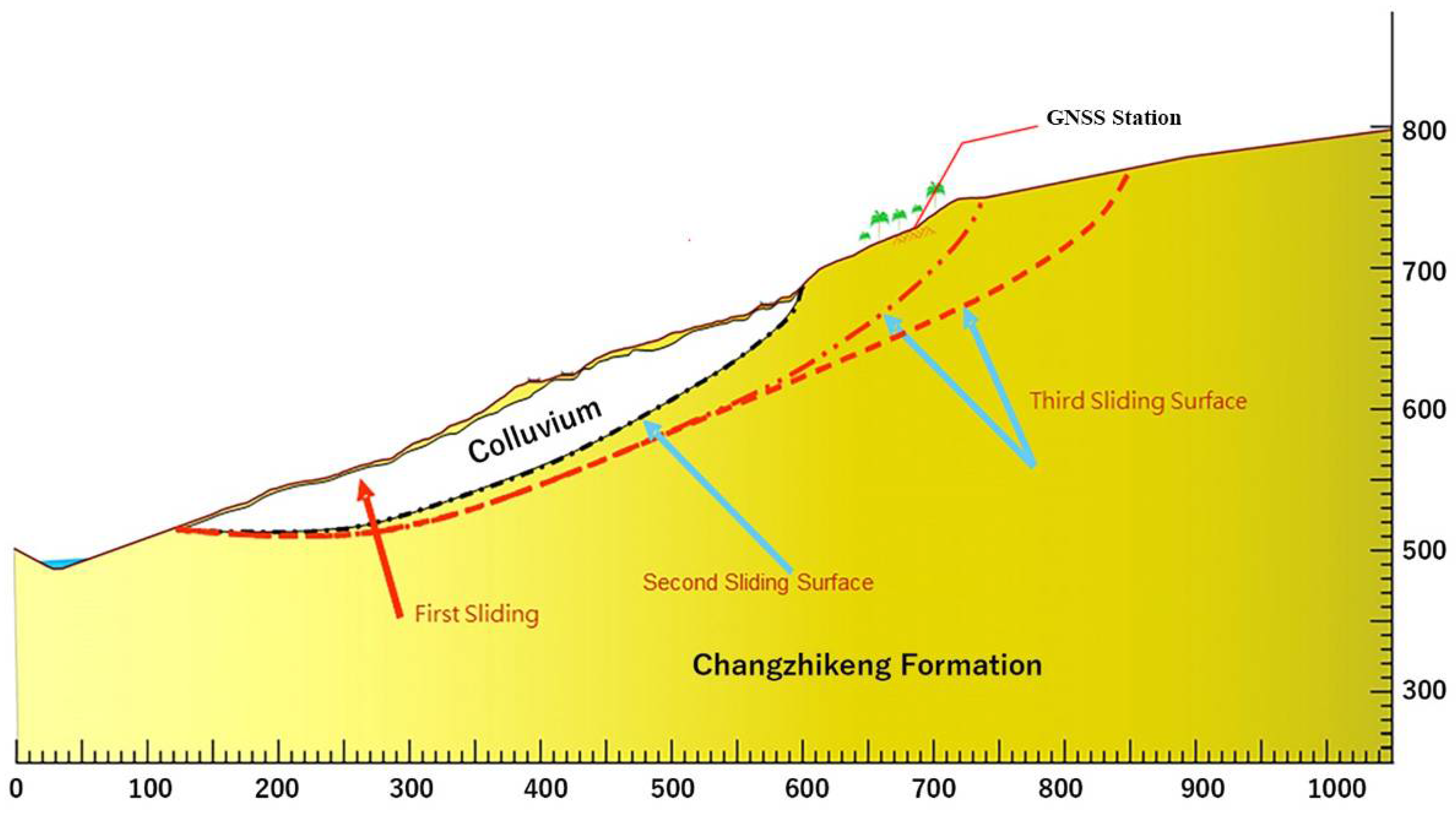
2.1. WuWanZai, Ali Mt., as a Test Case
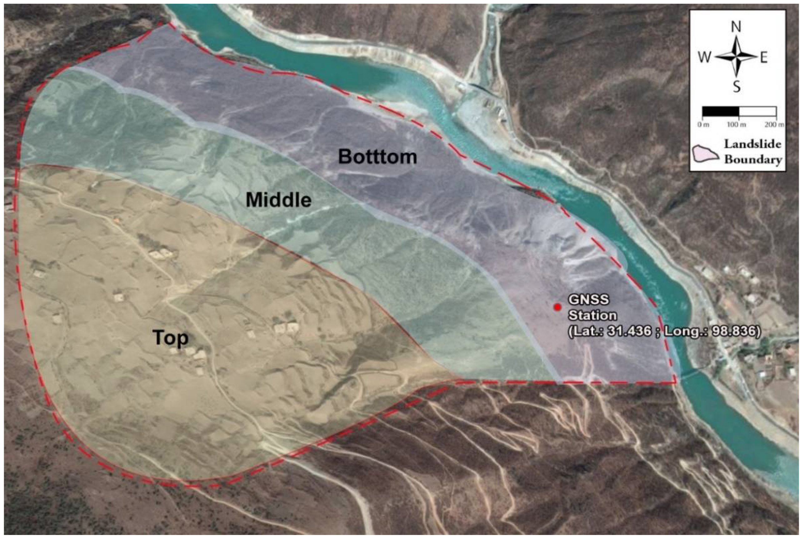
2.2. Woda Landslide as a Validation Case
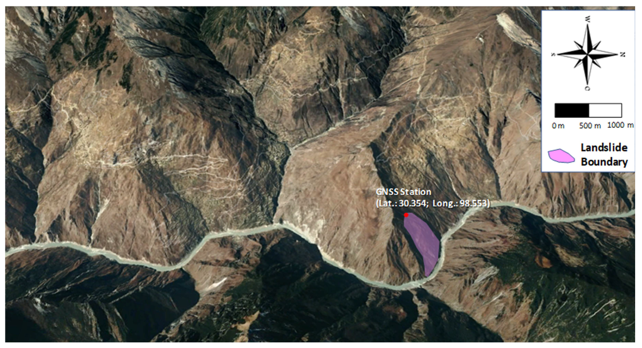
2.3. Shadong Landslide Case
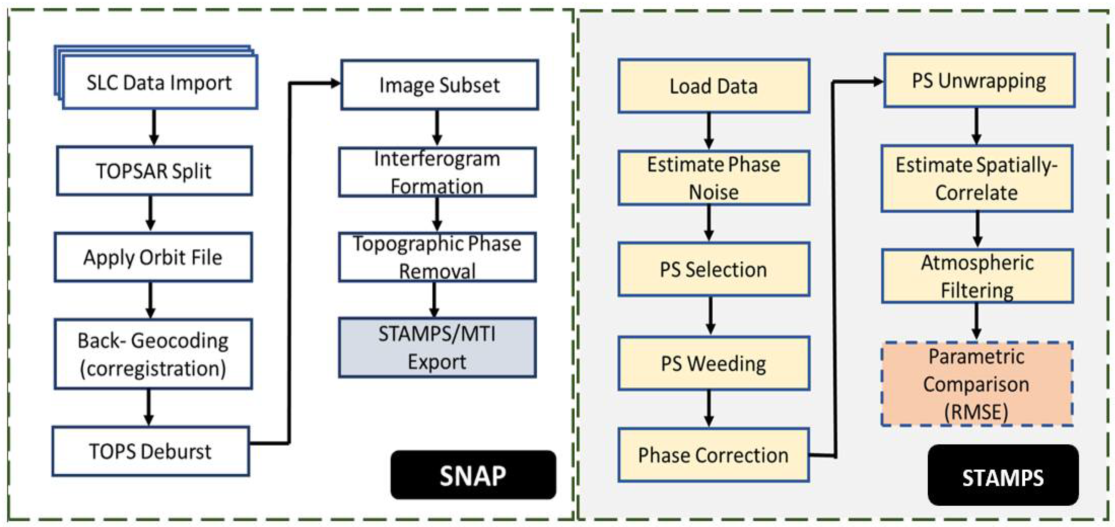
3. Materials and Methods
3.1. Processing Flow
3.2. PS-InSAR Processing
3.3. SBAS Processing
3.4. Data Processing in StaMPS
3.4.1. Amplitude Dispersion
3.4.2. Phase Unwrapping
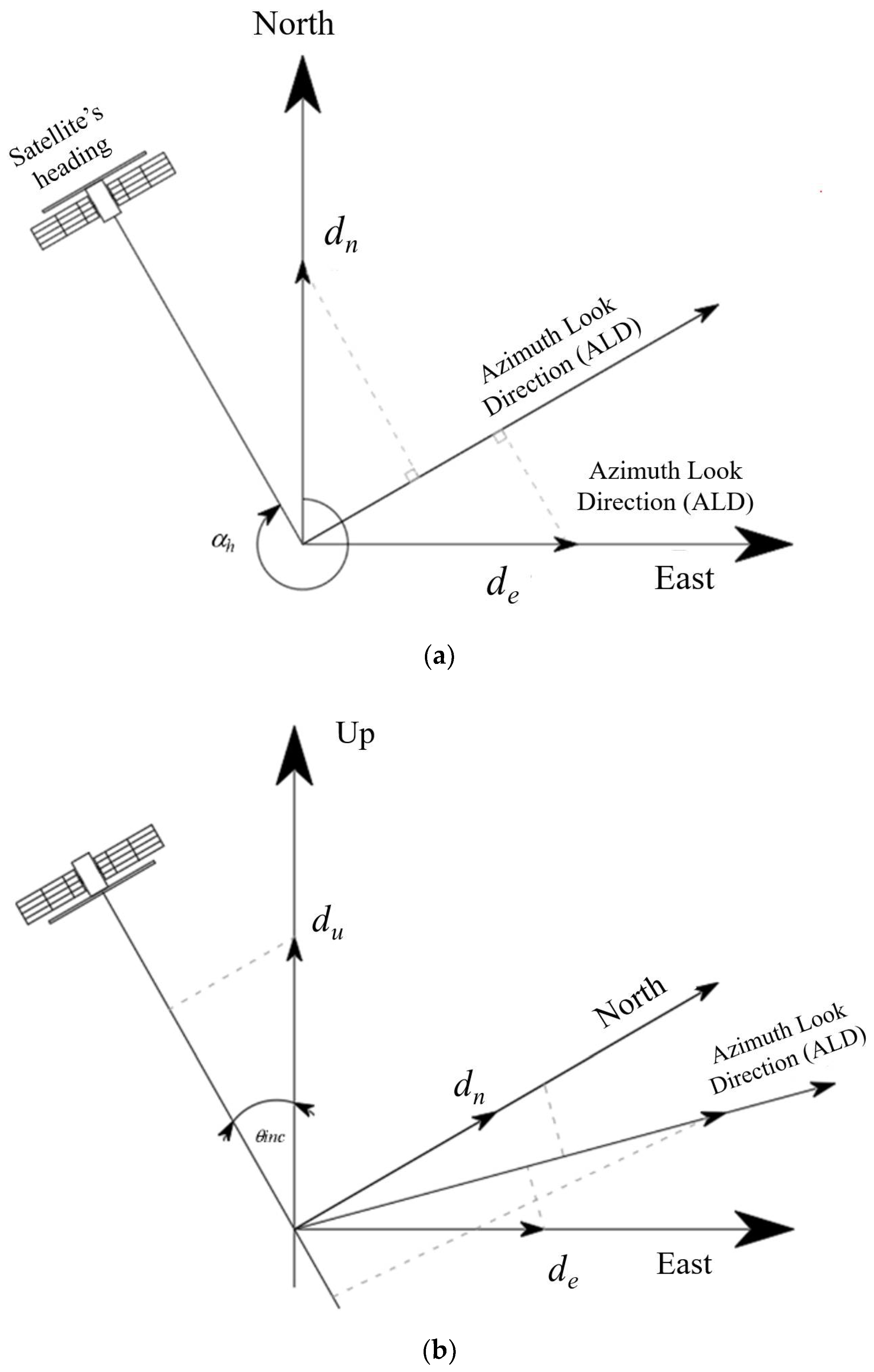
3.5. GNSS to LOS Projection
4. Results
4.1. The Preliminary Test Case at WuWanZai
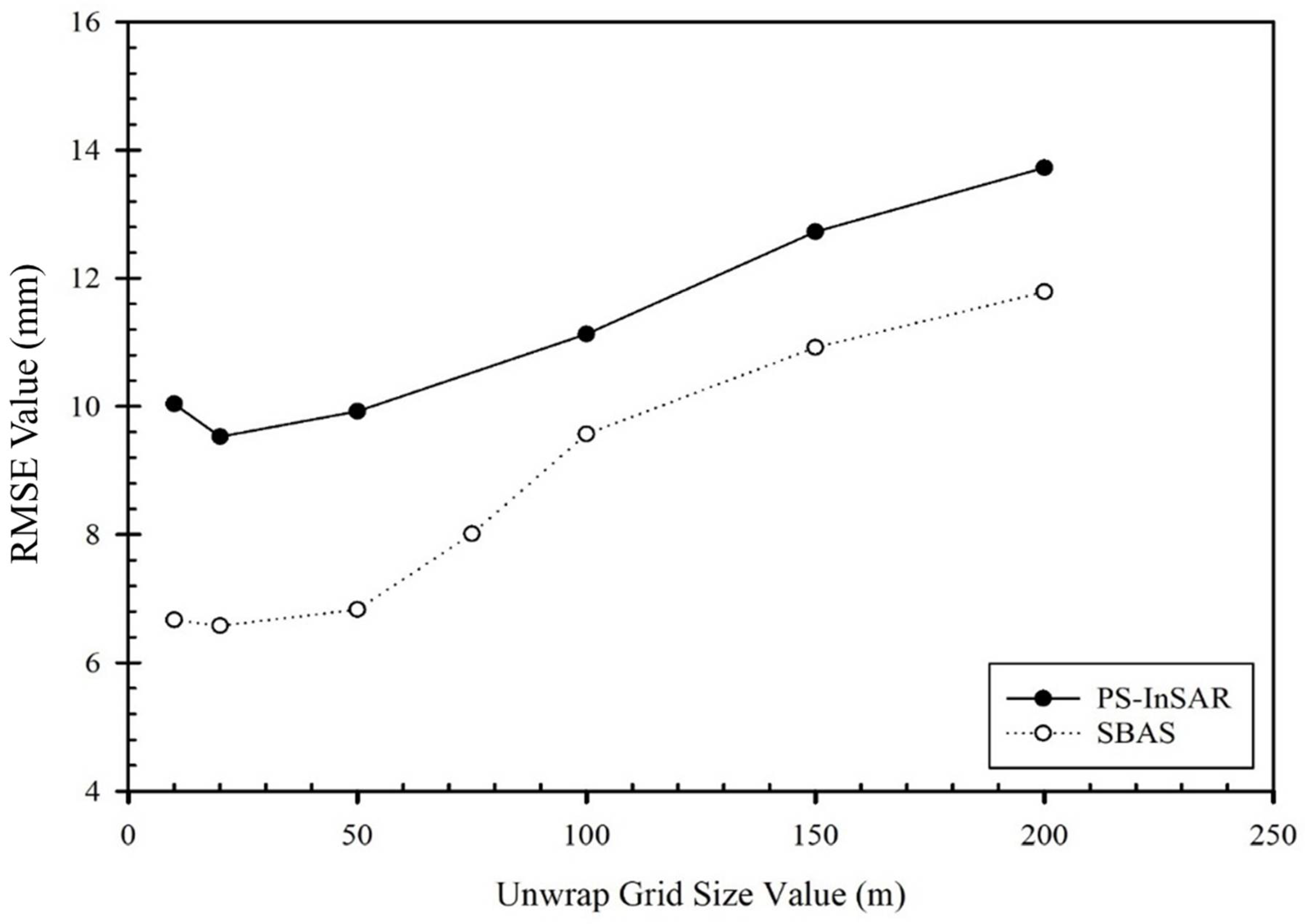
4.1.1. Unwrap Grid Size
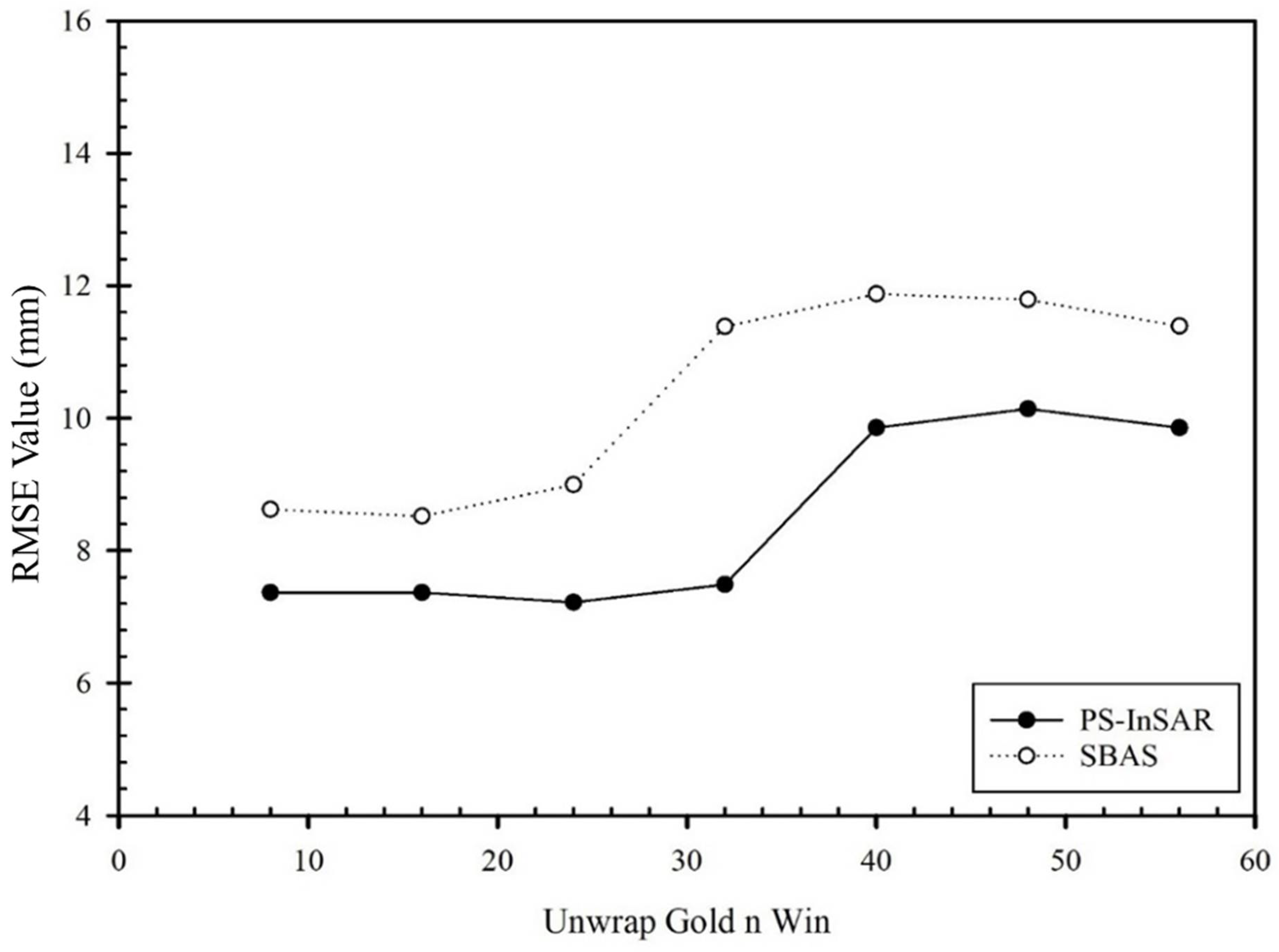
4.1.2. Unwrap_Gold_n_Win
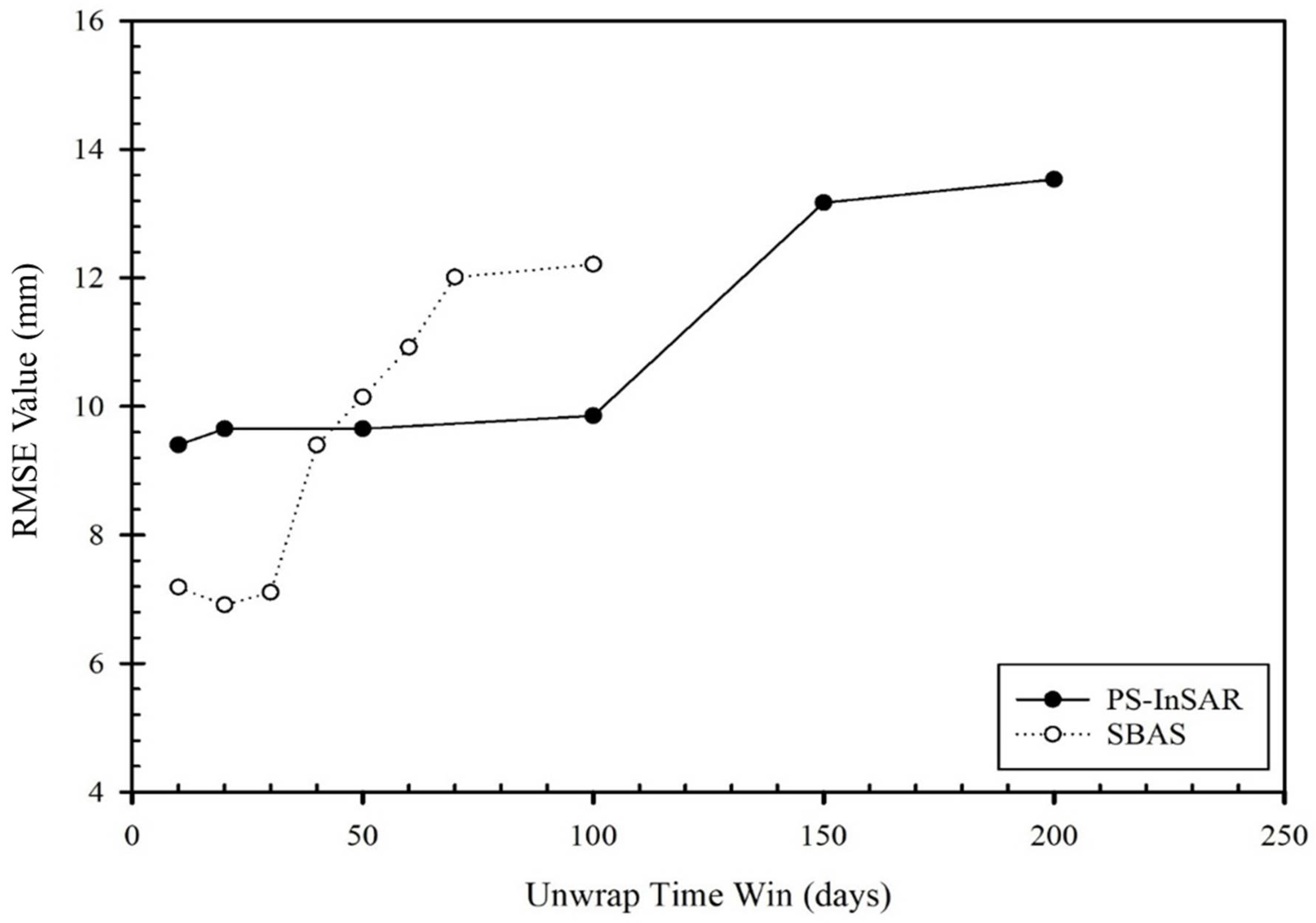
4.1.3. Unwrap_Time_Win
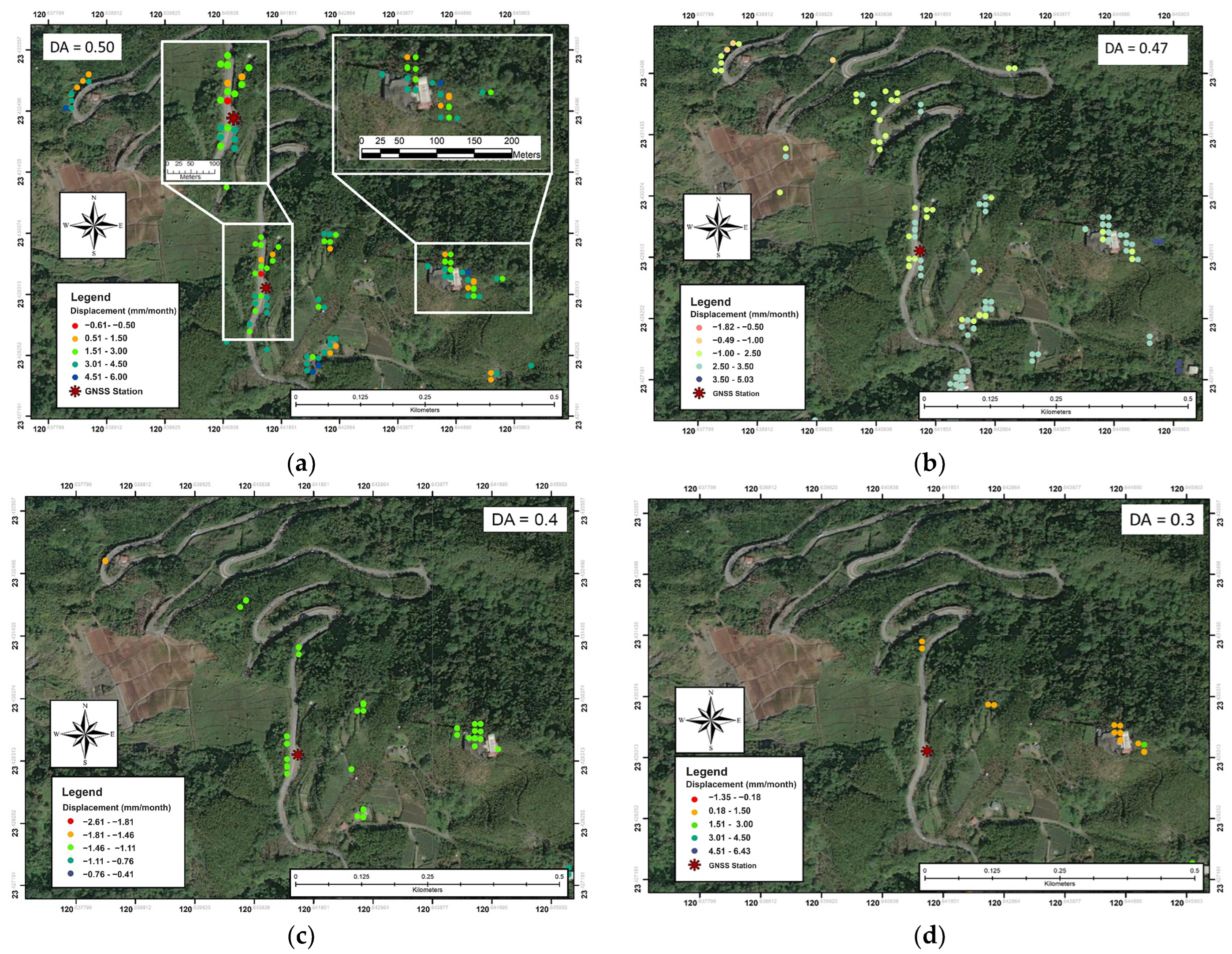
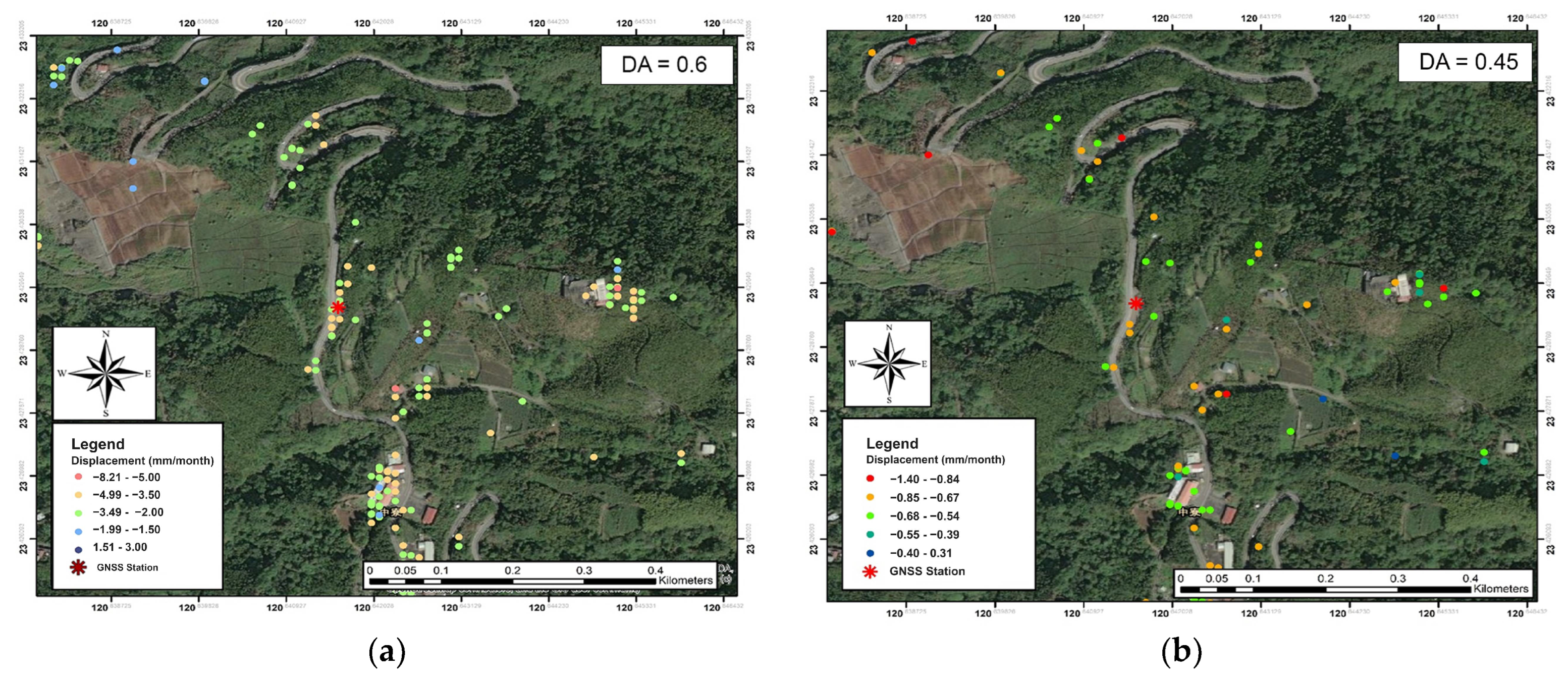
4.1.4. Amplitude Dispersion
4.1.5. Summary of Test
4.2. Verified Case Results at Woda Landslide
4.3. Verified Case Results at Shadong Landslide
5. Discussion
- (1)
- The parameter shown in Table 1 was tested in the Woda and Shadong landslides. Based on these tests, the significant change between default and optimal parameters was sound. However, the DA depends on the number of InSAR images, and the proper DA threshold proposed in this manuscript is only suitable for the limited number of images at WuWanZai, as well as the Woda and Shadong cases.
- (2)
- Due to the limitations of landslide monitoring, sometimes only one GNSS station can proceed as the actual displacement reference, such as in the case of WuWanZai and previous studies. Thus, this study aimed to rapidly evaluate the optimal values for this kind of practical landslide implementation using the RMSE compared to GNSS positioning, not the value of velocity standard deviation from the InSAR. However, during the testing and validation, the lowest value of the RMSE from GNSS could not be closer to zero. This was probably caused by the shift from the wrapped phase to the relatively unwrapped phase [48]. Initially, the StaMPS method provided a solution to this problem by estimating the value in the unwrapping step concerning the reference PS in each time increment, leading to the three-dimensional unwrapping [37].
- (3)
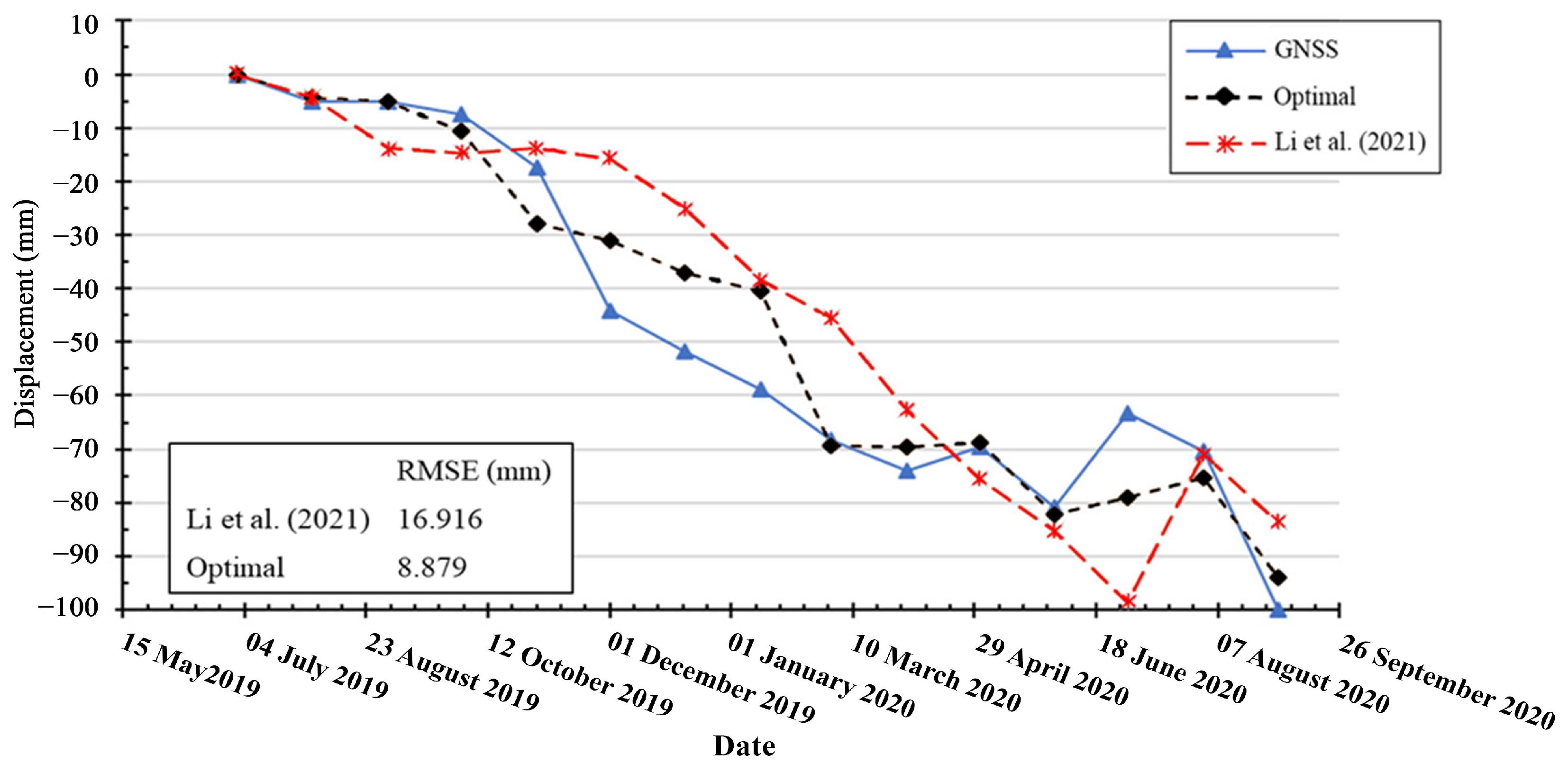
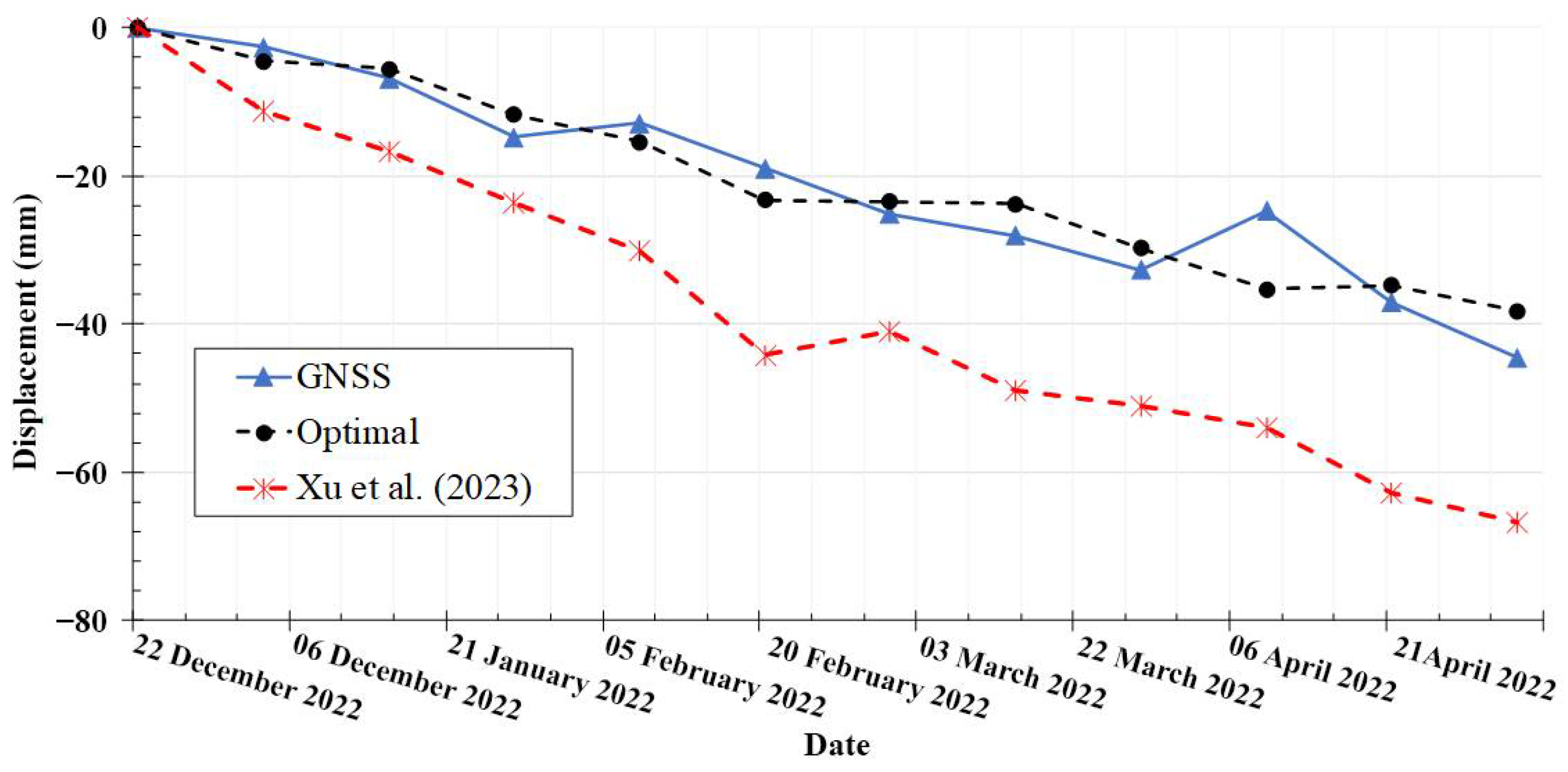
- The Woda and Shadong results indicated only a few PSs in the PS-InSAR result, resulting in the difficulty of GNSS comparison. This explained that the fewer Sentinel-1 images affected the reliability of the PS-InSAR results. Fortunately, the images of the SBAS-InSAR were sufficient for the analyses in both cases. The SBAS-InSAR results were much closer to the GNSS positioning with the optimal suggestions.
- (4)
- In the PS-InSAR processing, the atmospheric phase screen (APS) plays a pivotal role in accurately estimating deformation values. The spatial–temporal variations due to APS are the dominant error source in interferograms as ghost fringes unrelated to topography or deformation [55]. Although this study did not consider the APS effect for accurate landslide monitoring, the significance of APS should be added in the next phase for comprehending its contribution.
- (5)
- The early warning threshold for landslides is challenging. The current Sentinel 1A sampling rate for specific areas is over ten days, resulting in limited temporal resolution and insufficient real-time early warning for landslides during rainfall or earthquake events. Thus, fusion analysis of multi-resolution SAR images from different satellites is preferred [56], as well as the enhancement from multi-sensor and multi-scale approaches [57].
6. Conclusions
Author Contributions
Funding
Data Availability Statement
Conflicts of Interest
References
- Zhang, Y.; Meng, X.M.; Dijkstra, T.A.; Jordan, C.J.; Chen, G.; Zeng, R.Q.; Novellino, A. Forecasting the magnitude of potential landslides based on InSAR techniques. Remote Sens. Environ. 2020, 241, 111738. [Google Scholar] [CrossRef]
- Hoek, E.; Bray, J.W. Rock Slope Engineering, 3rd ed.; The Institution of Mining and Metallurgy: London, UK, 1981. [Google Scholar]
- Varnes, D.J. Slope Movement Types and Processes. Special Report 176: Landslides: Analysis and Control; Schuster, R.L., Krizek, R.J., Eds.; Transportation and Road Research Board, National Academy of Science: Washington, DC, USA, 1978; pp. 11–33. [Google Scholar]
- Corominas, J.; Moya, J.; Lloret, A.; Gili, J.A.; Angeli, M.G.; Pasuto, A.; Silvano, S. Measurement of landslide displacements using a wire extensometer. Eng. Geol. 2000, 55, 149–166. [Google Scholar] [CrossRef]
- Gurbuz, G.; Aktug, B.; Jin, S.; Kutoglu, S.H. A GNSS-based near real time automatic Earth Crust and Atmosphere Monitoring Service for Turkey. Adv. Space Res. 2020, 66, 2854–2864. [Google Scholar] [CrossRef]
- Simeoni, L.; Mongiovi, L. Inclinometer monitoring of the Castelrotto landslide in Italy. J. Geotech. Geoen. Eng. 2007, 133, 653–666. [Google Scholar] [CrossRef]
- Stark, T.D.; Choi, H. Slope inclinometers for landslides. Landslides 2008, 5, 339–350. [Google Scholar] [CrossRef]
- Xu, Q.; Peng, D.; Fan, X.; Zhu, X.; He, C. Presenting Some Successful Cases of Regional Landslides Early Warning Systems in China. In Understanding and Reducing Landslide Disaster Risk: Volume 3 Monitoring and Early Warning; Casagli, N., Tofani, V., Sassa, K., Eds.; Springer International Publishing: Berlin/Heidelberg, Germany, 2021; pp. 279–286. [Google Scholar]
- Carlà, T.; Tofani, V.; Lombardi, L.; Raspini, F.; Bianchini, S.; Bertolo, D.; Thuegaz, P.; Casagli, N. Combination of GNSS, satellite InSAR, and GBInSAR remote sensing monitoring to improve the understanding of a large landslide in high alpine environment. Geomorphology 2019, 335, 62–75. [Google Scholar] [CrossRef]
- Purkis, S.; Klemas, V. Remote Sensing and Global Environmental Change; John Wiley & Sons Ltd.: Chichester, UK, 2011. [Google Scholar]
- Li, Z.; Cao, Y.; Wei, J.; Duan, M.; Wu, L.; Hou, J.; Zhu, J. Time-series InSAR ground deformation monitoring: Atmospheric delay modeling and estimating. Earth-Sci. Rev. 2019, 192, 258–284. [Google Scholar] [CrossRef]
- Samodra, G.; Chen, G.; Sartohadi, J.; Kasama, K. Generating landslide inventory by participatory mapping: An example in Purwosari Area, Yogyakarta, Java. Geomorphology 2018, 306, 306–313. [Google Scholar] [CrossRef]
- Bell, R.; Cepeda, J.; Devoli, G. Landslide susceptibility modeling at catchment level for improvement of the landslide early warning system in Norway. In Proceedings of the Third World Landslide Forum, Beijing, China, 2–6 June 2014. [Google Scholar]
- Effat, H.A.; Hegazy, M.N. Mapping landslide susceptibility using satellite data and spatial multicriteria evaluation: The case of Helwan District, Cairo. Appl. Geomat. 2014, 6, 215–228. [Google Scholar] [CrossRef]
- Arabameri, A.; Saha, S.; Roy, J.; Chen, W.; Blaschke, T.; Tien, B.D. Landslide susceptibility evaluation and management using different machine learning methods in the Gallicash River watershed, Iran. Remote Sens. 2020, 12, 475. [Google Scholar] [CrossRef]
- Sun, Q.; Zhang, L.; Ding, X.L.; Hu, J.; Li, Z.W.; Zhu, J.J. Slope deformation prior to Zhouqu, China landslide from InSAR time series analysis. Remote Sens. Environ. 2015, 156, 45–57. [Google Scholar] [CrossRef]
- Antonielli, M.; Rocca, B.; Dei, C. A-DInSAR performance for updating landslide inventory in mountain areas: An example from Lombardy region (Italy). Geosciences 2019, 9, 364. [Google Scholar] [CrossRef]
- Mishra, V.; Jain, K. Satellite based assessment of artificial reservoir induced landslides in data scarce environment: A case study of Baglihar reservoir in India. J. Appl. Geophys. 2022, 205, 104754. [Google Scholar] [CrossRef]
- Hu, J.; Wu, W.; Motagh, M.; Qin, F.; Wang, J.; Pan, S.; Guo, J.; Zhang, C. FIM-based DSInSAR method for mapping and monitoring of reservoir bank landslides: An application along the Lancang River in China. Landslides 2023, 10, 1–17. [Google Scholar] [CrossRef]
- Campbell, J.B.; Wynne, R.H. Introduction to Remote Sensing, 5th ed.; The Guilford Press: New York, NY, USA, 2011. [Google Scholar]
- Florinsky, I. Digital Terrain Analysis in Soil Science and Geology; Academic Press: London, UK, 2016. [Google Scholar]
- Townsend, P.A. Estimating forest structure in wetlands using multitemporal SAR. Remote Sens. Environ. 2002, 79, 288–304. [Google Scholar] [CrossRef]
- Ottinger, M.; Kuenzer, C. Spaceborne L-Band synthetic aperture radar data for geoscientific analyses in coastal land applications: A review. Remote Sens. 2020, 12, 2228. [Google Scholar] [CrossRef]
- McCormack, H.; Thomas, A.; Solomon, I. The Capabilities and Limitations of Satellite InSAR and Terrestrial Radar Interferometry; Fugro NPA Limited: Edenbridge, UK; Fugro Geotechnical Services Limited: Hong Kong, China, 2011. [Google Scholar]
- Gabriel, A.K.; Goldstein, R.M.; Zebker, H.A. Mapping small elevation changes over large areas: Differential radar interferometry. J. Geophys. Res. 1989, 94, 9183–9191. [Google Scholar] [CrossRef]
- Ferretti, A.; Prati, C.; Rocca, F. Permanent scatterers in SAR interferometry. IEEE Trans. Geosci. Remote Sens. 2001, 39, 8–20. [Google Scholar] [CrossRef]
- Berardino, P.; Fornaro, G.; Lanari, R.; Sansosti, E. A new algorithm for surface deformation monitoring based on small baseline differential SAR interferograms. IEEE Trans. Geosci. Remote Sens. 2002, 40, 2375–2383. [Google Scholar] [CrossRef]
- Höser, T. Analysing the Capabilities and Limitations of InSAR Using Sentinel-1 Data for Landslide Detection and Monitoring. Master’s Thesis, University of Bonn, Bonn, Germany, 2018. [Google Scholar]
- Intrieri, E.; Raspini, F.; Fumagalli, A.; Lu, P.; Del Conte, S.; Farina, P.; Allievi, J.; Ferretti, A.; Casagli, N. The Maoxian landslide as seen from space: Detecting precursors of failure with Sentinel-1 data. Landslides 2017, 15, 123–133. [Google Scholar] [CrossRef]
- Monti-Guarnieri, A.; Manzoni, M.; Giudici, D.; Recchia, A.; Tebaldini, S. Vegetated Target Decorrelation in SAR and Interferometry: Models, Simulation, and Performance Evaluation. Remote Sens. 2020, 12, 2545. [Google Scholar] [CrossRef]
- Paloscia, S.; Fontanelli, G.; Lapini, A.; Santi, E.; Pettinato, S.; Notarnicola, C.; Chiarito, E.; Cuozzo, G.; Tapete, D.; Cigna, F. SAR multi-frequency observations of vegetation in agricultural and mountain areas. In Proceedings of the 2020 XXXIIIrd General Assembly and Scientific Symposium of the International Union of Radio Science, Rome, Italy, 29 August–5 September 2020. [Google Scholar]
- Li, B.; Jiang, W.; Li, Y.; Luo, Y.; Qian, H.; Wang, Y.; Jiao, Q.; Zhang, Q.; Zhou, Z.; Zhang, J. Monitoring and analysis of Woda landslide stability (China) combined with InSAR, GNSS and meteorological data. Nat. Hazards Earth Syst. Sci. Discuss Prepr. 2021, 2021, 1–23. [Google Scholar]
- Xu, Q.; Zhao, B.; Dai, K.; Dong, X.; Li, W.; Zhu, X.; Yang, Y.; Xiao, X.; Wang, X.; Huang, J.; et al. Remote sensing for landslide investigations: A progress report from China. Eng. Geol. 2023, 321, 107156. [Google Scholar] [CrossRef]
- Central Geological Survey. Taiwan 1:50,000 Scale Geological Maps, Sheet 45 (ZhongPu); Central Geological Survey (CGS), Ministry of Economic Affairs: Taiwan, China, 2009.
- Chang, M.S.; Chien, S.C.; Li, P.J.; Chuang, C.C.; Tsai, W.Y.; Wang, H.S. Landslip problems and mitigation considerations of slopes along Mileage 39K (old Mileage 25K) of Province Road 18, Taiwan. Taiwan Highw. Eng. 2008, 34, 2–21. (In Chinese) [Google Scholar]
- u-blox. ZED-F9P Moving Base Application Note; u-blox: Thalwil, Switzerland, 2020. [Google Scholar]
- Hooper, A.; Zebker, H.; Segall, P.; Kampes, B. A new method for measuring deformation on volcanoes and other natural terrains using InSAR persistent scatterers. Geophys. Res. Lett. 2004, 31, 1–5. [Google Scholar] [CrossRef]
- Hooper, A. A multi-temporal InSAR method incorporating both persistent scatterer and small baseline approaches. Geophys. Res. Lett. 2008, 35, L16302. [Google Scholar] [CrossRef]
- Hayati, N.; Niemeier, W.; Sadarviana, V. Ground deformation in the Ciloto Landslides area revealed by multi-temporal InSAR. Geosciences 2020, 10, 156. [Google Scholar] [CrossRef]
- Foroughnia, F.; Nemati, S.; Maghsoudi, Y.; Perissin, D. An iterative PS-InSAR method for the analysis of large spatio-temporal baseline data stacks for land subsidence estimation. Int. J. Appl. Earth Obs. Geoinf. 2019, 74, 248–258. [Google Scholar] [CrossRef]
- Lanari, R.; Casu, F.; Manzo, M.; Zeni, G.; Berardino, P.; Manunta, M.; Pepe, A. An overview of the small baseline subset algorithm: A DInSAR technique for surface deformation analysis. Pure Appl. Geophys. 2007, 164, 637–661. [Google Scholar] [CrossRef]
- Cascini, L.; Fornaro, G.; Peduto, D. Advanced low- and full-resolution DInSAR map generation for slow-moving landslide analysis at different scales. Eng. Geol. 2010, 112, 29–42. [Google Scholar] [CrossRef]
- Sandwell, D.T.; Mellors, R.J.; Tong, X.; Wei, M.; Wessel, P. GMTSAR: An InSAR Processing System Based on Generic Mapping Tools; Scripps Institution of Oceanography: San Diego, CA, USA, 2011. [Google Scholar]
- Ferretti, A.; Monti-Guarnieri, A.; Prati, C.; Rocca, F.; Fletcher, E.B.K. InSAR Principles: Guidelines for SAR Interferometry Processing and Interpretation; ESA Publications: Noordwijk, The Netherlands, 2007. [Google Scholar]
- Kampes, B.M. Radar Interferometry Persistent Scatterer Technique; Springer: Dordrecht, The Netherlands, 2006. [Google Scholar]
- Hooper, A.; Segall, P.; Zebker, H. Persistent scatterer interferometric synthetic aperture radar for crustal deformation analysis, with application to Volcán Alcedo, Galápagos. J. Geophys. Res. 2007, 112, B07407. [Google Scholar] [CrossRef]
- Wasowski, J.; Bovenga, F. Investigating landslides and unstable slopes with satellite multi temporal interferometry: Current issues and future perspectives. Eng. Geol. 2014, 174, 103–138. [Google Scholar] [CrossRef]
- Osmanoğlu, B.; Sunar, F.; Wdowinski, S.; Cabral-Cano, E. Time series analysis of InSAR data: Methods and trends. J. Photogramm. Remote Sens. 2016, 115, 90–102. [Google Scholar] [CrossRef]
- Hanssen, R.F. Radar Interferometry: Data Interpretation and Error Analysis; Kluwer Academic Publishers: London, UK, 2001. [Google Scholar]
- Lazecky, M.; Hatton, E.; Gonzalez, P.J.; Hlavacova, I.; Jirankova, E.; Dvorak, F.; Sustr, Z.; Martinovic, J. Displacements monitoring over Czechia by IT4S1 system for automatised interferometric measurements using Sentinel-1 Data. Remote Sens. 2020, 12, 2960. [Google Scholar] [CrossRef]
- Dong, J.; Zhang, L.; Liao, M.; Gong, J. Improved correction of seasonal tropospheric delay in InSAR observations for landslide deformation monitoring. Remote Sens. Environ. 2019, 233, 111370. [Google Scholar] [CrossRef]
- Goldstein, R.M.; Werner, C.L. Radar interferogram filtering for geophysical applications. Geophs. Res. Lett. 1998, 25, 4035–4038. [Google Scholar] [CrossRef]
- Colesanti, C.; Wasowski, J. Investigating landslides with space-borne Synthetic Aperture Radar (SAR) interferometry. Eng. Geol. 2006, 88, 173–199. [Google Scholar] [CrossRef]
- Kampes, B.M. Displacement Parameter Estimation Using Permanent Scatterer Interferometry; Delft University of Technology: Delft, The Netherlands, 2005. [Google Scholar]
- Hu, Z.; Mallorquí, J.J. An Accurate Method to Correct Atmospheric Phase Delay for InSAR with the ERA5 Global Atmospheric Model. Remote Sens. 2019, 11, 1969. [Google Scholar] [CrossRef]
- Mazzanti, P.; Scancella, S.; Virelli, M.; Frittelli, S.; Nocente, V.; Lombardo, F. Assessing the Performance of Multi-Resolution Satellite SAR Images for Post-Earthquake Damage Detection and Mapping Aimed at Emergency Response Management. Remote Sens. 2022, 14, 2210. [Google Scholar] [CrossRef]
- Zocchi, M.; Kasaragod, A.K.; Jenkins, A.; Cook, C.; Dobson, R.; Oommen, T.; Van Huis, D.; Taylor, B.; Brooks, C.; Marini, R.; et al. Multi-Sensor and Multi-Scale Remote Sensing Approach for Assessing Slope Instability along Transportation Corridors Using Satellites and Uncrewed Aircraft Systems. Remote Sens. 2023, 15, 3016. [Google Scholar] [CrossRef]


| Parameter | Default Value | PS | SBAS |
|---|---|---|---|
| Amplitude Dispersion (DA) | 0.6 | 0.4–0.47 | ≥0.6 |
| Unwrap_grid_size (m) | 200 | 20 | 20 |
| Unwrap_gold_n_win | 32 | ≤32 | ≤24 |
| Unwrap_time_win (days) | 730 | ≤100 | ≤32 |
Disclaimer/Publisher’s Note: The statements, opinions and data contained in all publications are solely those of the individual author(s) and contributor(s) and not of MDPI and/or the editor(s). MDPI and/or the editor(s) disclaim responsibility for any injury to people or property resulting from any ideas, methods, instructions or products referred to in the content. |
© 2023 by the authors. Licensee MDPI, Basel, Switzerland. This article is an open access article distributed under the terms and conditions of the Creative Commons Attribution (CC BY) license (https://creativecommons.org/licenses/by/4.0/).
Share and Cite
Bahti, F.N.; Chung, C.-C.; Lin, C.-C. Parametric Test of the Sentinel 1A Persistent Scatterer- and Small Baseline Subset-Interferogram Synthetic Aperture Radar Processing Using the Stanford Method for Persistent Scatterers for Practical Landslide Monitoring. Remote Sens. 2023, 15, 4662. https://doi.org/10.3390/rs15194662
Bahti FN, Chung C-C, Lin C-C. Parametric Test of the Sentinel 1A Persistent Scatterer- and Small Baseline Subset-Interferogram Synthetic Aperture Radar Processing Using the Stanford Method for Persistent Scatterers for Practical Landslide Monitoring. Remote Sensing. 2023; 15(19):4662. https://doi.org/10.3390/rs15194662
Chicago/Turabian StyleBahti, Farid Nur, Chih-Chung Chung, and Chun-Chen Lin. 2023. "Parametric Test of the Sentinel 1A Persistent Scatterer- and Small Baseline Subset-Interferogram Synthetic Aperture Radar Processing Using the Stanford Method for Persistent Scatterers for Practical Landslide Monitoring" Remote Sensing 15, no. 19: 4662. https://doi.org/10.3390/rs15194662
APA StyleBahti, F. N., Chung, C.-C., & Lin, C.-C. (2023). Parametric Test of the Sentinel 1A Persistent Scatterer- and Small Baseline Subset-Interferogram Synthetic Aperture Radar Processing Using the Stanford Method for Persistent Scatterers for Practical Landslide Monitoring. Remote Sensing, 15(19), 4662. https://doi.org/10.3390/rs15194662