Article

Research on Climate Change in Qinghai Lake Basin Based on WRF and CMIP6

1
School of Water Resources and Hydropower Engineering, North China Electric Power University, Beijing 102206, China
2
State Key Laboratory of Simulation and Regulation of Water Cycle in River Basin, China Institute of Water Resources and Hydropower Research, Beijing 100038, China
3
Key Laboratory of River Basin Digital Twinning of Ministry of Water Resources, Beijing 100038, China
*
Author to whom correspondence should be addressed.
Remote Sens. 2023, 15(18), 4379; https://doi.org/10.3390/rs15184379
Submission received: 12 July 2023 / Revised: 30 August 2023 / Accepted: 1 September 2023 / Published: 6 September 2023

Abstract

:
Climate change directly affects water resources by changing temperature and precipitation and the responses of inland basins on plateaus to climate change show a certain pattern. To systematically evaluate the changing facts and evolution trend of temperature and precipitation in the Qinghai Lake Basin, the Weather Research and Forecasting Model (WRF) was used to simulate the spatial distribution of temperature and precipitation in typical periods of the current year based on the observations of hydrological and meteorological stations. Based on the output results of different climate models in CMIP6, the temporal changing trends of temperature and precipitation were predicted. The results showed that precipitation and runoff significantly increased compared to the past, and the lake level first decreased and then increased. In August 2020, the temperature and precipitation near the lake were higher than those in the other areas of the basin. In the future, temperature and precipitation will increase under the influence of different forcing scenarios with the temperature change being more significant. A close combination of observations and simulations will provide quantitative spatiotemporal data and technical support for future climate change adaptability research in the Qinghai Lake Basin.

Graphical Abstract

1. Introduction

Climate change is one of the most urgent environmental crises and a common challenge facing the world [1,2,3,4]. The sixth assessment report of the IPCC reported that 1970 to 2020 was the 50-year period with the fastest global surface temperature rise of the past 2000 years. Extreme precipitation intensity in most land areas at mid-latitudes is increasing. Extreme high temperatures and precipitation events are highly likely to occur more frequently and last longer [5,6]. China has become more severely affected by global warming, with the magnitude of warming exceeding the global average. The impact of climate change on humans is generally more harmful than beneficial and has seriously affected the safety of life and property, the social economy, and the ecological environment [7,8,9]. The Third National Assessment Report on Climate Change emphasized that 70% of natural disasters are related to extreme climate events. Therefore, the quantification of spatial numerical simulations and future predictions of temperature and precipitation in the context of climate change have become important topics in hydrology and meteorology [10,11].
Many studies have used long-term observational data to summarize the temporal and spatial evolution of temperature and precipitation [12,13,14,15]. Zhang [16] studied the flood events and precipitation data of typical cities in the Greater Bay Area over the past 100 years, summarized the characteristics of flood disasters, and revealed the driving factors of frequent flood disasters. Zahra [17] used four linear and nonlinear combination methods—namely correlation analysis, the Kopra function method, entropy weight method, and principal component analysis—to weigh and integrate data variables that affect water balance, such as temperature, precipitation, river flow, and soil moisture. Finally, a comprehensive drought index for monitoring hydrological, agricultural, and meteorological droughts was obtained. Numerical simulation is another basic method to study climate change because it can quantitatively separate and identify the effects of different factors. Yang [18] conducted a sensitivity analysis on 21 parameterized schemes of the regional climate model WRF, and quantitatively studied the number of samples and ensemble forecasting skills. Based on the evaluation results of comprehensive forecasting ability, a precipitation ensemble forecasting scheme was constructed. Finally, a more stable forecasting scheme was obtained. Saha [19] constructed a bias-corrected dataset using empirical quantile mapping based on 20 coupled models of CMIP6. It was found that extreme precipitation occurred more frequently on the west coast of India.
Compared to limited meteorological observation data, weather research and forecasting model (WRF) can provide richer spatial distribution information, which is helpful for revealing the spatial information of temperature and precipitation under the current climate change background [20,21]. The observation data of meteorological stations are more accurate; they can correct the deviation of the current numerical simulation results of meteorological elements and help to predict the future climate to reduce uncertainty [22,23,24]. The combination of these two methods compensates for the shortcomings of the single methods. The global climate model (GCM) is the main tool for predicting future climate change and evaluating the impact of climate change on the environment. However, the relatively low spatial resolution information has limited ability to predict and simulate regional climate change. Although the spatial resolution of the regional climate model is high, its prediction duration is relatively short, which cannot reflect the impact of future climate change and requires a lot of computer resources. Previous research has significant shortcomings regarding the combined application of these two modes. Therefore, it is important to study the spatiotemporal distribution of temperature and precipitation in the Qinghai Lake Basin by combining the characteristics of dynamic and statistical downscaling methods.
Qinghai Lake was formed due to geological processes and climate change. The fluctuation of the lake level and evolution of the surrounding environment are indicators and mediators of climate change in the Qinghai-Tibet Plateau [25,26]. The impact of climate change on meteorological elements has received considerable attention [27]. Based on historical observation series data of the Qinghai Lake Basin, this study systematically analyzed the changing facts and evolution laws of hydrological elements to determine the main driving factors of water level changes in Qinghai Lake from 1956 to 2020. The WRF regional climate model was used to simulate the typical current period to analyze the spatial distribution of meteorological elements. Based on the latest climate change model results, a climate model and a forced scenario suitable for the Qinghai Lake Basin were selected to predict future changes in temperature and precipitation in the Qinghai Lake Basin. The close combination of observation dataset and numerical simulation has realized the comprehensive assessment of climate change in time and space. It provides theoretical support and a data basis for future sustainable development and the response to climate change in the Qinghai Lake Basin, which is an innovative research idea.

2. Materials and Methods

2.1. Study Area

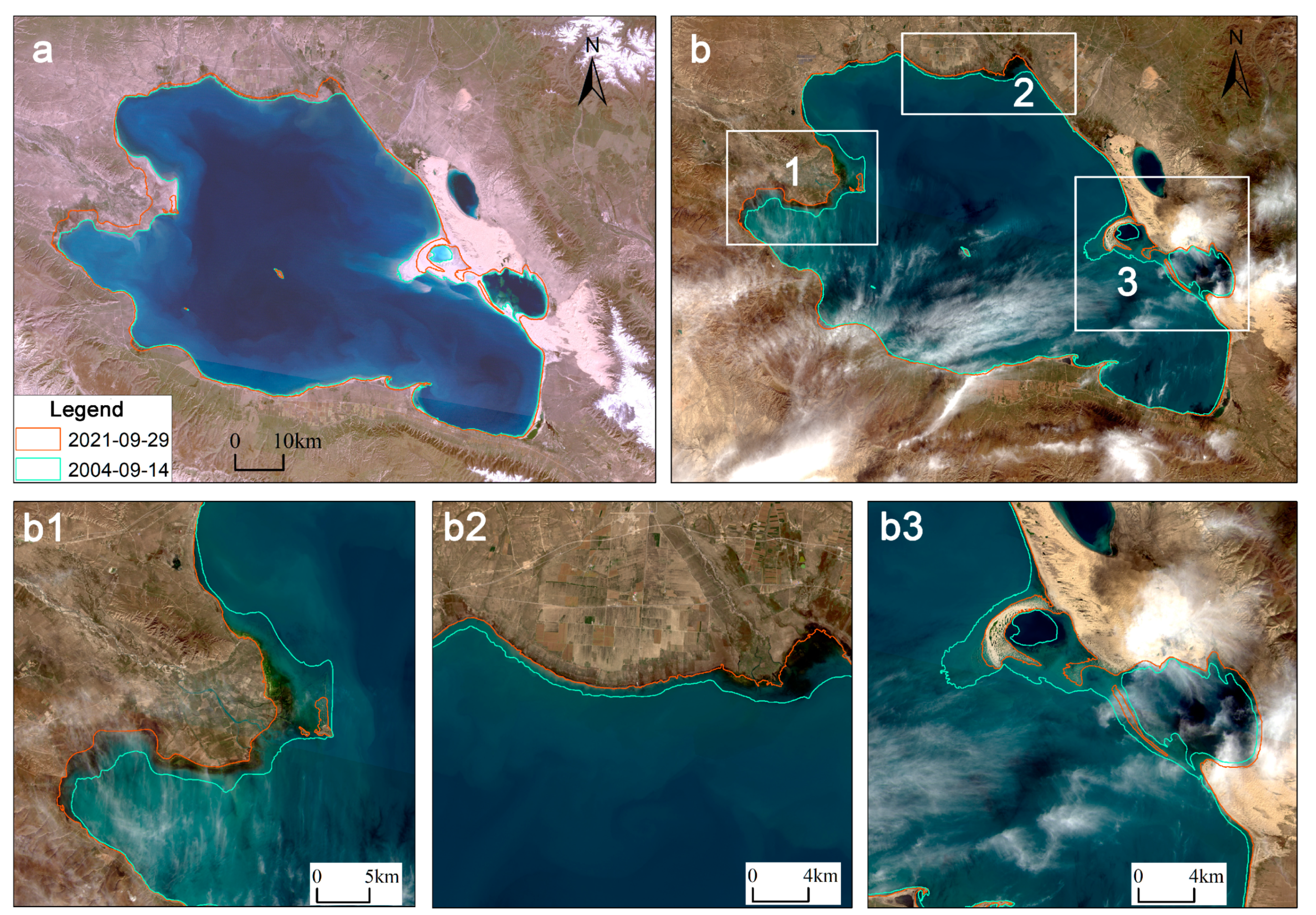
As shown in Figure 1a, the Qinghai Lake Basin is located in the northeast of the Qinghai-Tibet Plateau, with a geographical location between 36°15′–38°20′ north latitude and 97°50′–101°20′ east longitude [28]. The topography of the basin is generally high in the northwest, low in the southeast, high in the surrounding areas, and low in the middle, with an altitude of 3109–5209 m (Figure 1b). It is a closed inland lake basin with a total area of 29,662.69 km2. The landscape of the Qinghai Lake Basin is diverse and consists of a lakeside plain, alluvial plain, low mountains, an ice platform, and modern middle mountains. There are more than 50 large and small rivers around Qinghai Lake, which are asymmetrical. Most of the rivers are distributed on the northern, northwestern, and southwestern shores of Qinghai Lake and the runoff depth decreases from northwest to southeast [29]. In recent years, the climate in the Qinghai Lake Basin has shown significant warming and humidification trends due to the influence of global climate change. The water level has continually increased and the water area has expanded. Owing to the differences in the topography of the lake area, the change trend of the lake shoreline differed. Figure 2 shows the detailed changes in the lake area of Qinghai Lake in 2021 compared to 2004 (the year with the lowest water level) and the remote sensing images. The red line represents the range of Qinghai Lake in 2021 and the green line represents the range of Qinghai Lake in 2004. Comparing the topographic maps and remote sensing images in 2021 and 2004, it can be seen that the three areas in Figure 2(b1–b3) had the most significant changes in the lake surface line, whereas the changes in the southern shore of the lake were relatively small. The upper edge of the eastern, northern, and western shores of Qinghai Lake was 0.3–0.9 km in most areas and 1.5 km in relatively few areas.
The Qinghai Lake Basin is located in a cold and semi-arid region with a plateau continental climate. The overall climate characteristics are as follows: low precipitation, rain, and heat in the same season; high evaporation; distinct dry and wet seasons; and sufficient light and strong sunshine. Many meteorological disasters occur in the basin and northwest winds prevail. Temperature is slightly higher in the southeast and slightly lower in the northwest. The annual precipitation is relatively low, with the eastern and southern regions having slightly higher precipitation than the northern and western regions. Hydrometeorology and other factors change uniquely and are extremely sensitive to global changes [30,31]. The Qinghai Lake Basin is an important source of water vapor in high-altitude cold and arid areas of the plateau. It is an important barrier to maintaining ecological security in the northeast of the Qinghai-Tibet Plateau. Therefore, a deeper understanding of the historical changes and future development trends of meteorological factors will help reveal the impact of climate change on water resources and the ecological environment in the Qinghai Lake Basin.

2.2. WRF Configuration and Data Sources

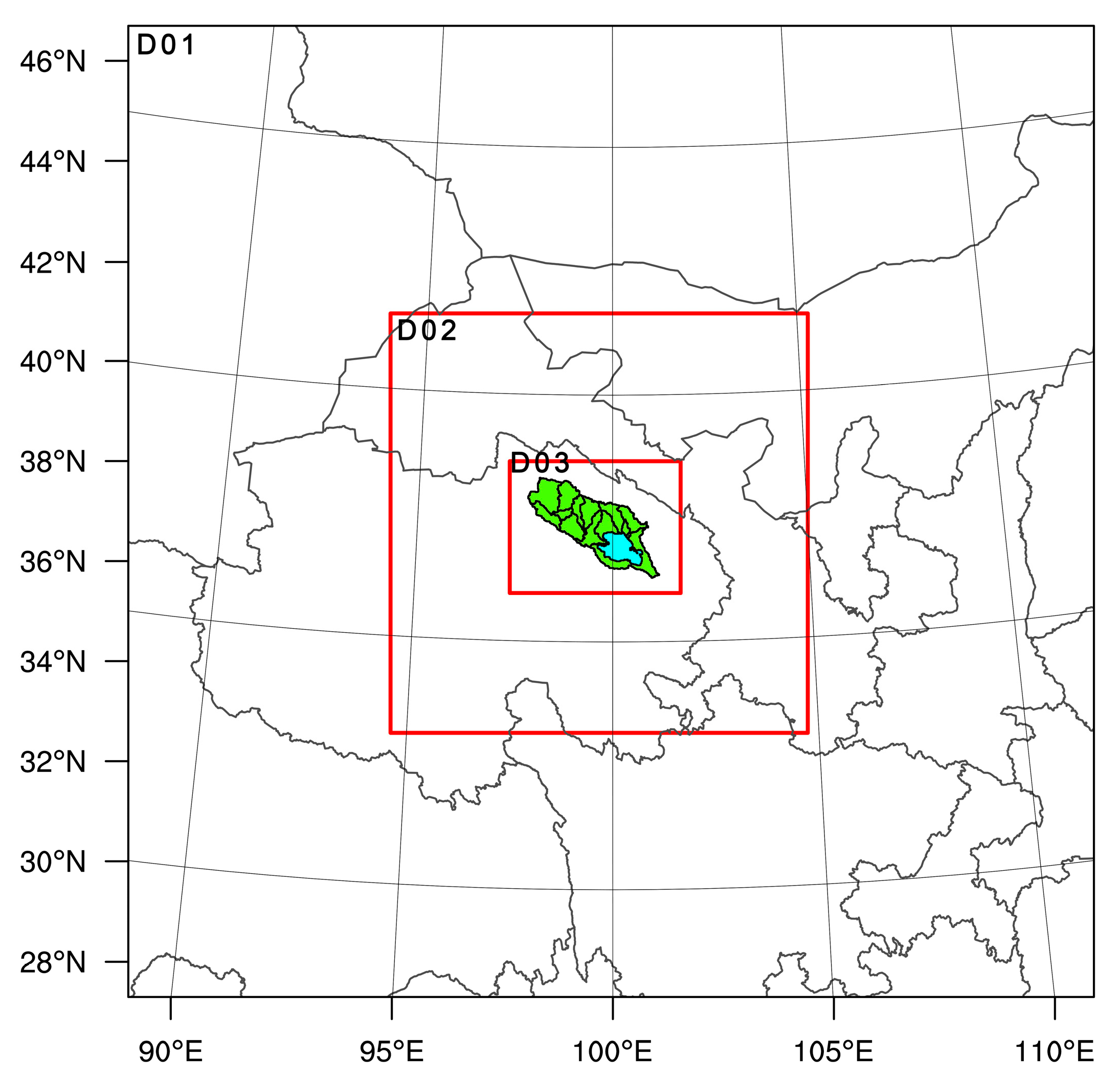
The regional climate model WRF was used to simulate the current climate in the Qinghai Lake Basin. The WRF is a mesoscale meteorological research model that uses both mathematical and physical models to simulate various meteorological processes and phenomena. As the study area is located in a plateau region, the underlying surface is more complex and has strong spatial variability. Therefore, it is necessary to establish a smaller-scale grid to obtain high-resolution hydrological and meteorological simulation results [32]. The WRF simulation adopted a three-layer grid-nesting scheme. As shown in Figure 3, the grid sizes of each layer were 27, 9, and 3 km from the outside to the inside and the grid points of each layer were 82 × 82, 106 × 106, and 130 × 100. The D03 area covered the entire Qinghai Lake Basin. The central coordinates of the simulation area are 37.65°N and 99.96°E. The Arakawa grid point was used horizontally. The terrain that followed the mass coordinates was adopted in the vertical direction, with 34 vertical layers. The simulated calculation time step was 108 s (four times the spacing between the D01 grids).
When running the WRF model, NCEP final analysis data provided by the National Center for Environmental Prediction in the United States were used as an external forcing field (https://rda.ucar.edu/datasets/ds083.2/ (accessed on 5 April 2023)). The spatial resolution was 1° × 1° and the temporal resolution was 6 h. The territorial data for the model were downloaded from the official website (https://www2.mmm.ucar.edu/wrf/users/download/get_sources_wps_geog.html (accessed on 5 April 2023)). The surface data used were MODIS 30 s resolution underlying surface data. Figure 4 shows that the land use types of the Qinghai Lake Basin mainly include water areas, grasslands, and shrubs. Forests, farmlands, and wetlands are also present in some areas.
Based on a literature review and experiments on the WRF simulation of temperature and precipitation in the study area under high-temperature conditions [33,34,35,36], the regional applicability of the WRF model physical process parameterization scheme was evaluated. A more accurate and reasonable combination of physical process parameterization schemes describing regional temperature and precipitation was selected: the Noah land surface model, Yonsei University boundary layer scheme, WSM 5-class microphysics scheme, Rapid Radiative Transfer Model longwave radiation scheme, Dudhia shortwave radiation scheme, and Kain–Fritsch cumulus parameterization scheme. The cumulus convection parameterization scheme was opened at the outermost layer. The other two layers were closed to provide more accurate simulation results. The selected physical process parameterization scheme is presented in Table 1. When running the WRF model, the lake model was named based on the land use type of the water area.
To understand the spatial distribution of temperature and precipitation during the high-temperature period in summer in the Qinghai Lake Basin, a representative summer period was selected for the numerical simulation calculation and analysis. Because the high-resolution WRF model will consume more computing resources, combined with the actual situation of researchers, this study selected 25 July to 31 August 2020, as the typical summer simulation period. The first week was the adjustment time of the WRF model and August was the analysis period for the model simulation. High-temperature weather and precipitation processes occurred during the selected simulation period. This is consistent with the characteristics of the rainy and hot seasons in the study area.

2.3. CMIP6-Related Settings and Data

Global climate models have been greatly improved and developed in recent decades. However, because of inherent systematic deviation and coarse spatial resolution, the simulation accuracy needs to be improved when using a global climate model to study the impact of climate change. To better study the climate analysis and future predictions of the Qinghai Lake Basin, it is necessary to statistically downscale the global climate model [37]. The basic idea of statistical downscaling is to establish a statistical relationship between large-scale climate conditions (mainly atmospheric circulation) and regional climate elements using years of observation data. This statistical relationship is used to downscale the output data of a global climate model. Finally, the information of regional climate elements is obtained [38,39].
For the CMIP6 model data, historical (1995–2014) and future (2015–2100) daily precipitation and temperature data of CMIP6 were selected (https://esgf-node.llnl.gov/projects/cmip6 (accessed on 10 May 2023)). The first experimental results of the GCMs (r1i1p1f1) were used to minimize the randomness and uncertainty in the model selection process. Four future scenarios were selected to predict future temperature and precision changes in the Qinghai Lake Basin under different forcing scenarios: low forcing, SSP1-2.6; medium forcing, SSP2-4.5 and SSP3-7.0; and high forcing, SSP5-8.5. Based on a literature investigation of climate models in the Qinghai Lake Basin, three climate models (MIROC6, MRI-ESM2-0, and IPSL-CM6A-LR) were selected to predict future trends in temperature and precipitation in the Qinghai Lake Basin. See Table 2 for details of the selected models.
To verify the accuracy of the three climate models, the delta method was used to correct the deviation between the historical data simulation results of the climate model and the CN05.1 observation results. The CN05.1 observation dataset is a set of gridded datasets with a latitude and longitude resolution of 0.25° × 0.25° based on observation data from more than 2400 ground meteorological stations in China. It is widely used in climate simulation and interpolation analysis [40]. The delta correction method considers the observation as a contemporary climate. The climate change signal is superimposed on the observation directly (for temperature) or proportionally (for precipitation) as the future climate. The deviation in the model did not change over time for each grid point [41].
The specific practice process of the delta method was as follows: first, the monthly average temperature of the GCM and multi-year monthly average temperature were calculated and subtracted from the observation dataset of CN05.1. The deviation between the climate model and the observed data was obtained. Finally, the average deviation of the multi-year monthly average temperature was subtracted from the monthly data of the climate model GCM to achieve the monthly deviation correction of the GCM.
The calculation formula for monthly deviation is:
delta{moni} = gcm{moni} − obs{moni}
The monthly correction formula is:
gcm(down){moni} = gcm{moni} − delta{moni}
where gcm{moni} is the monthly average temperature of GCM, obs{moni} is the monthly average observed temperature of CN05.1, delta{moni} is the deviation between gcm and the observed data, and gcm(down){moni} is the monthly average temperature of gcm after downscaling correction.
For precipitation, the ratio correction method was used because, unlike continuous variables such as temperature, precipitation is a discrete variable as it does not occur every day. The average deviation of the monthly average precipitation over many years was obtained by comparing the observation dataset of CN05.1 with the precipitation of the GCM. The formula for calculating the deviation and monthly correction of precipitation was as follows:
delta{monj} = obs{monj}/gcm{monj}
gcm(down){monj} = gcm{monj} × delta{monj}
where gcm{monj} is the monthly cumulative precipitation of the GCM, obs{monj} is the monthly cumulative observed precipitation of CN05.1, and delta{monj} is the deviation between the GCM and the observed data. gcm(down){monj} is the monthly cumulative precipitation of the GCM after downscaling correction.
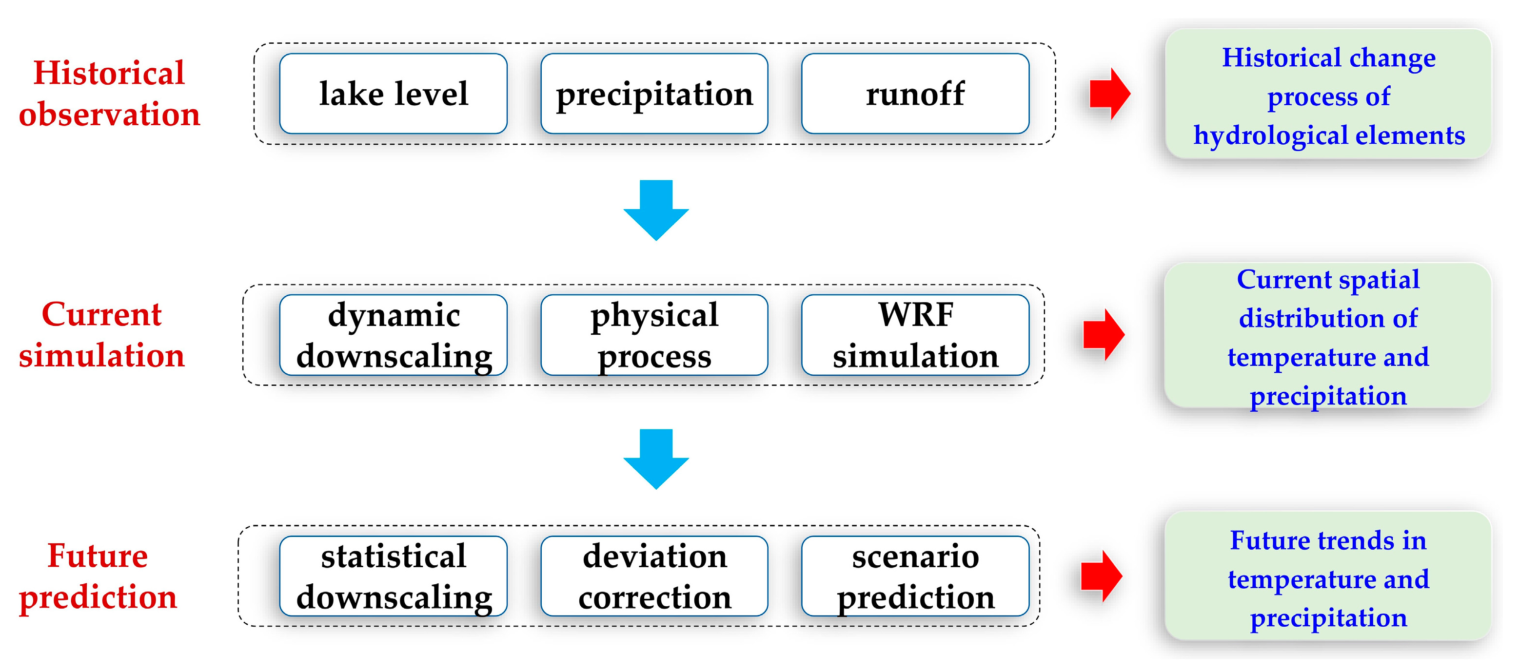
The analysis process and logical sequence of this study were sorted out, and a logical framework diagram was created. As shown in Figure 5, the change law of hydrological elements in the Qinghai Lake Basin was analyzed using historical observation data. WRF was used to simulate the current typical time period and analyze the spatial distribution of temperature and precipitation. Based on CMIP6 and different forced scenarios, future predictions of temperature and precipitation were realized.

3. Results and Analysis

3.1. Statistics of Hydrometeorological Elements

As there is no national meteorological station in the Qinghai Lake Basin, the historical observation data used in this study were obtained from the Hydrology and Water Resources Forecast Center of Qinghai Province. Figure 1 shows the Tianjun meteorological station, Buha Estuary hydrological station, Gangcha hydrological station, and Xiashe water level station.
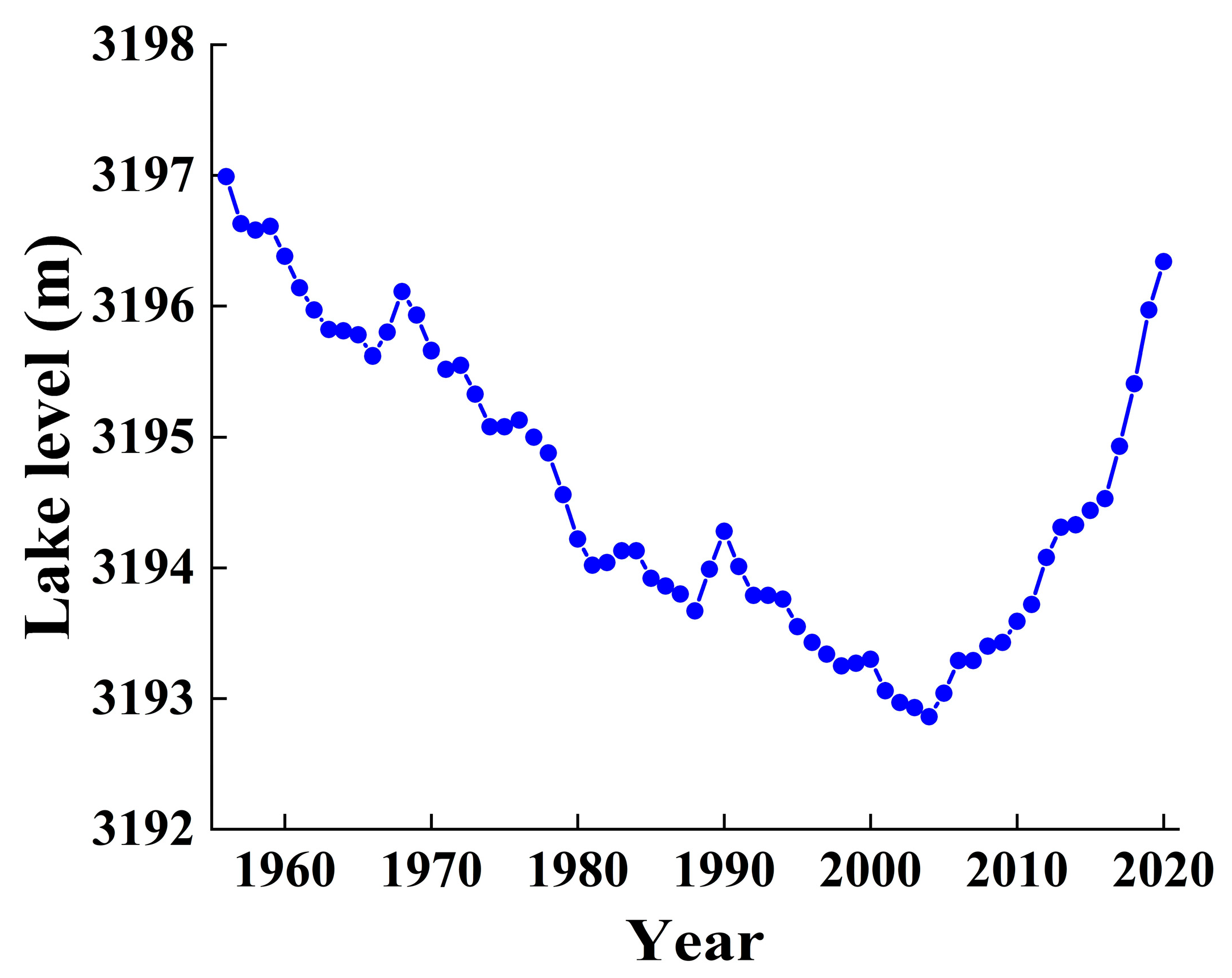
Figure 6 shows the change in lake level at the Xiashe Station in Qinghai Lake from 1956 to 2020. We found that the highest lake level occurred in 1956, at 3196.99 m, and the lowest lake level occurred in 2004, at 3192.86 m. From 1956 to 2004, the lake level showed an obvious downward trend, with a total decline of 4.13 m and annual average decline rate of 0.086 m. From 2004 to 2020, the lake level of Qinghai Lake showed an obvious upward trend. In 2020, the lake level reached 3196.34 m, with a total increase of 3.48 m and annual average increase rate of 0.218 m. The rise in the lake level in Qinghai Lake was closely related to the increase in precipitation and runoff under the background of climate change.
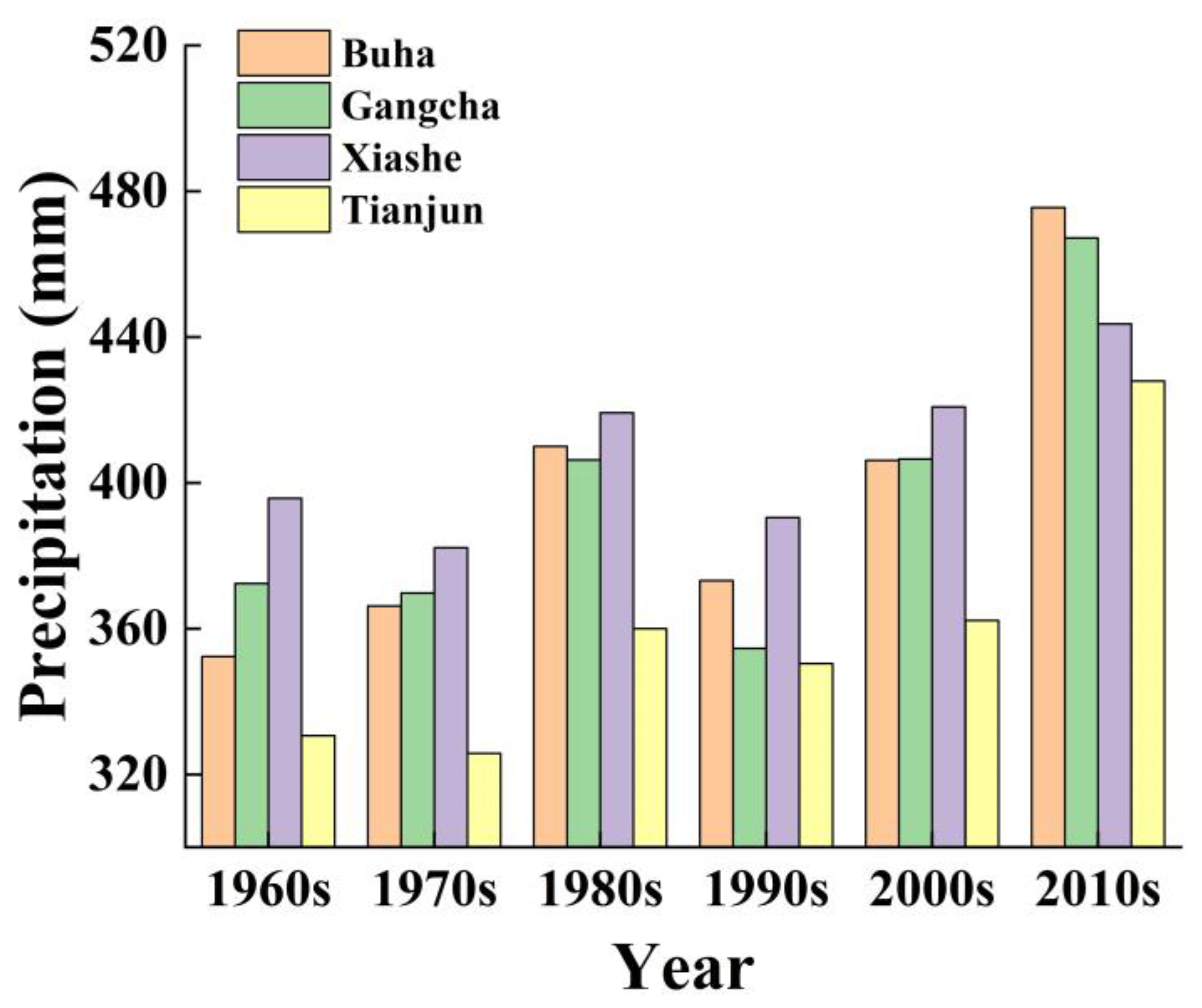
The change in precipitation over the years was analyzed according to historical observation data of the Qinghai Lake Basin. As precipitation can vary significantly from year to year and extreme events can impact annual values, changes in the trend are not always obvious. Therefore, average precipitation values over 10 consecutive years were selected to prevent the impact of extreme events skewing the study of the precipitation time series from 1961 to 2020. Figure 7 shows that precipitation has an upward trend in the Qinghai Lake Basin. Each station showed that the precipitation from 2011 to 2020 was the highest during the past 60 years, reaching 453.54 mm. The combined annual average precipitation for the other years was less than 400 mm. Climate change has significantly increased precipitation in the Qinghai Lake Basin. The precipitation at Xiashe Station was higher than that at the Tianjun Meteorological Station, indicating that the precipitation in the Qinghai Lake area was higher than that in the basin above the lake.
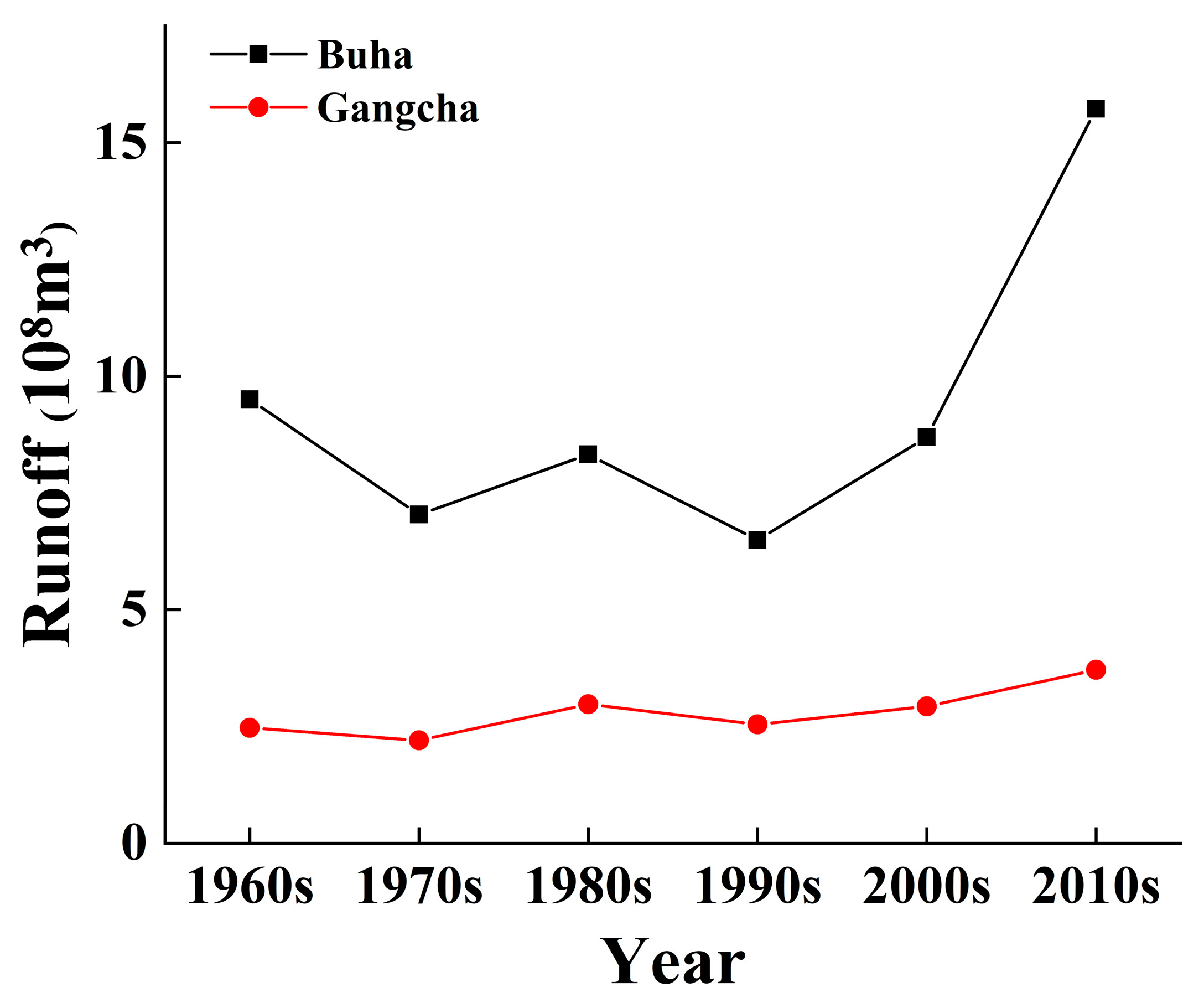
Figure 8 shows the variation in runoff over time in the Qinghai Lake Basin. We found that runoff at the Buha and Gangcha stations peaked during 2011–2020. The runoff at Buha Estuary station reached 1.572 billion m3. This was almost twice the average annual runoff of the past 50 years. The runoff of Gangcha station reached 371 million m3. The synchronous increase in runoff and precipitation into the lake confirmed the accuracy of the above figures for the lake-level rise in Qinghai Lake.

3.2. Spatial Numerical Simulation of Metrological Elements

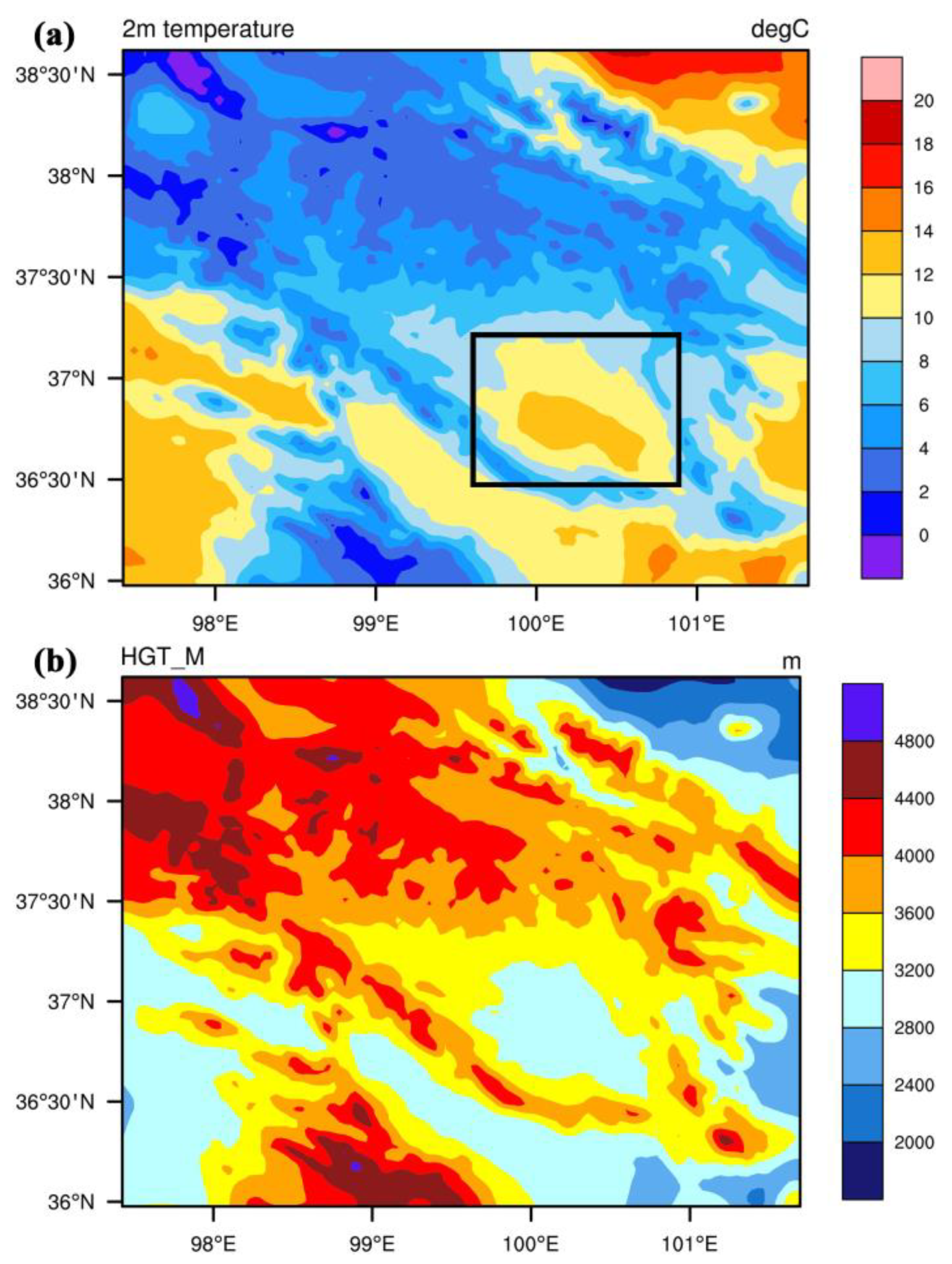
This study magnifies the results for the D03 region. Figure 9a shows the simulation results of the 2 m average temperature near the ground in Qinghai Lake and its surrounding areas during the summer simulation analysis period (0:00 on 1 August to 24:00 on 31 August). The 2 m average temperature near the lake surface was approximately 11 °C in the Qinghai Lake area in August. The temperature was the highest in the center of the lake, which was higher than that in other areas of Qinghai Lake Basin (approximately 7 °C). The main reason for this was that the water level in Qinghai Lake reached 3196.34 m in 2020 (Figure 9b), which was much lower than that of the northwest Qinghai Lake Basin (more than 4000 m). The temperatures above Qinghai Lake are low because it is at a low altitude. Water evaporation in the underlying surface of the Qinghai Lake area absorbs sensible heat flux above the lake surface. Therefore, the temperature difference between the Qinghai Lake area and surrounding regions was reduced to a certain extent.
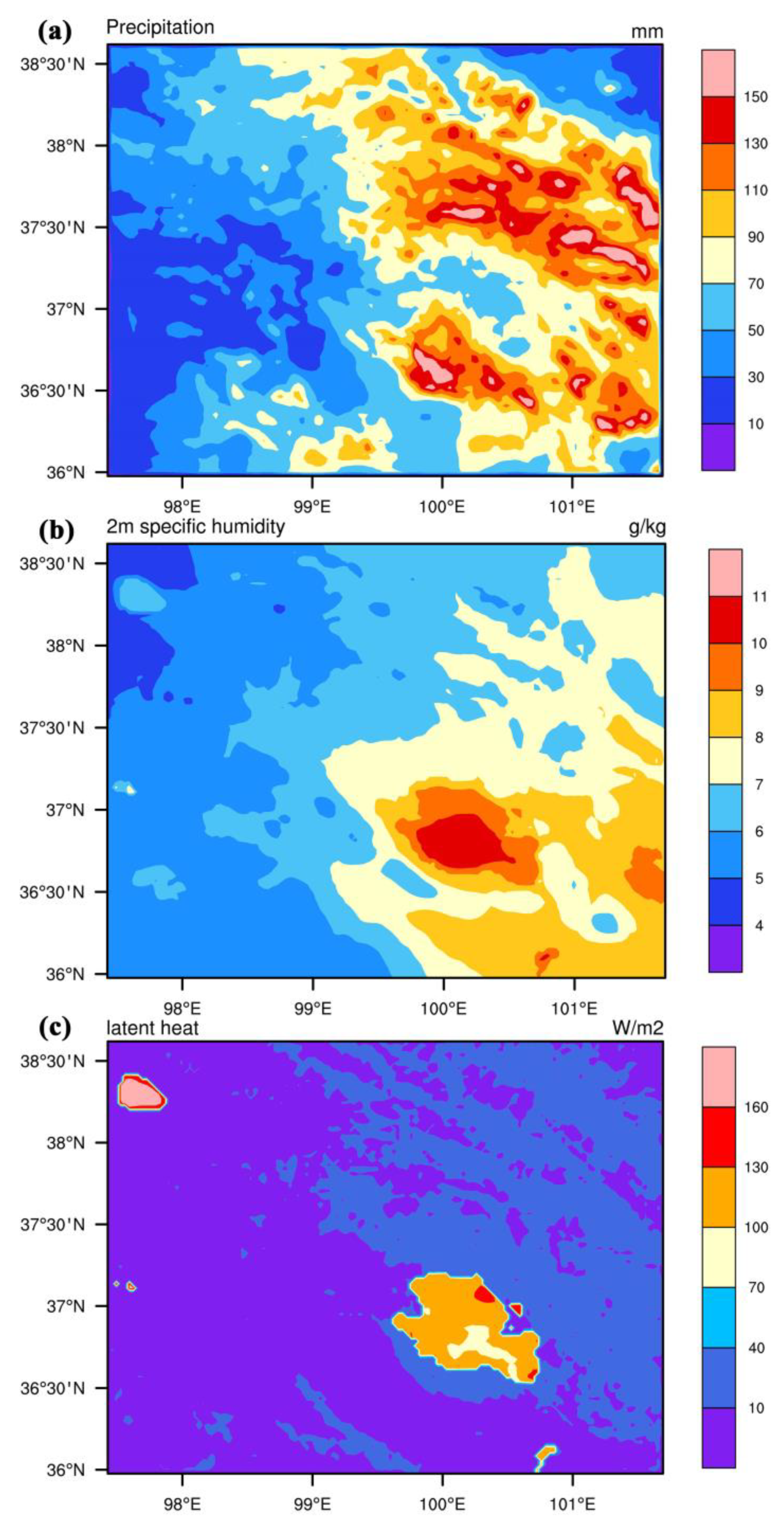
Figure 10a shows the simulation results for precipitation in the Qinghai Lake Basin during the summer simulation analysis period. As shown in Figure 10a, the total precipitation in August was more than 100 mm in Qinghai Lake, which was much higher than that in other areas of the Qinghai Lake Basin (less than 70 mm). Precipitation was the highest in the central area of the lake. The edge of the lake was greatly affected by the low temperature and air circulation in the surrounding area and the distance between the center of the lake and the edge of the lake was large, which was less affected by the surrounding cold air. The relatively high temperature and water surface promoted the upward circulation of the water vapor. Higher temperatures and humidity in the center of the lake were conducive to the formation of convective precipitation above the lake center. As shown in Figure 10b, the specific humidity near the lake surface was greater than 10 g/kg in August in the Qinghai Lake area, whereas the specific humidity in the other areas was approximately 6 g/kg. The specific humidity of the air was higher than that of the surrounding areas, providing a source of water vapor for convective precipitation. In contrast, the temperature above Qinghai Lake was higher than that in the surrounding region (Figure 9a) and the evaporation of the water surface was more active, which caused the latent heat flux in the Qinghai Lake area to be significantly higher than that in the surrounding area (Figure 10c). These factors are interrelated and jointly promote an increase in precipitation in the Qinghai Lake area.

3.3. Prediction Results of Climate Elements

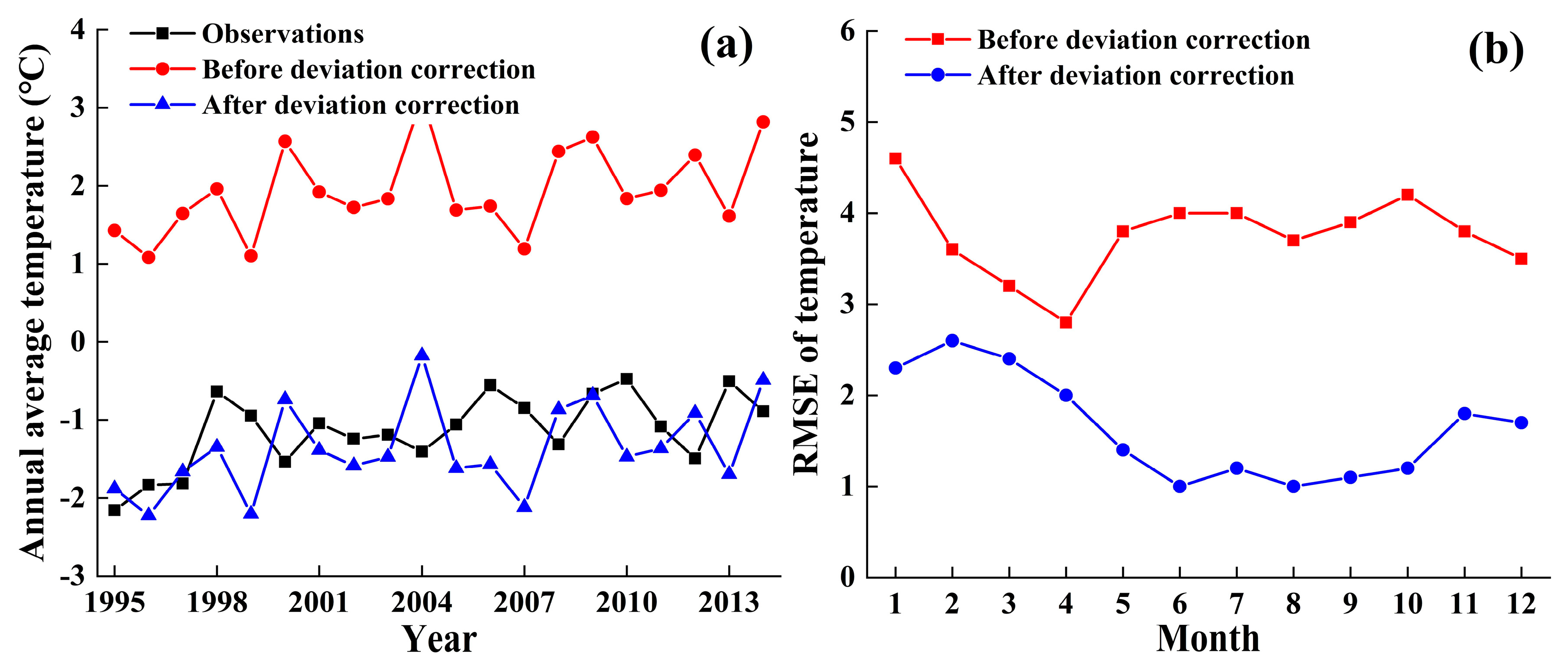
Taking the MIROC6 climate model as an example, temperature and precipitation data from 1995 to 2014 were corrected. The principle and process of deviation correction for the other two climate models were identical to those for MIROC6. Figure 11a shows the annual average temperature comparison between the MIROC6 model deviation correction and the CN05.1 observation dataset for 1995–2014. We found that the simulation results before MIROC6 correction generally overestimated the temperature. The annual average temperature simulation value for 1995–2014 was 1.9 °C and the annual average temperature observation value of CN05.1 was −1.13 °C. After the deviation correction, the root mean square error (RMSE) between the model and the observed values was reduced from 3.39 to 0.73 °C. The simulation accuracy of the model improved significantly after scale reduction. Figure 11b compares the mean monthly RMSE before and after deviation correction. The simulation accuracy of the model improved more in May–October; that is, in the relatively warm season, and less in the other relatively cold seasons.
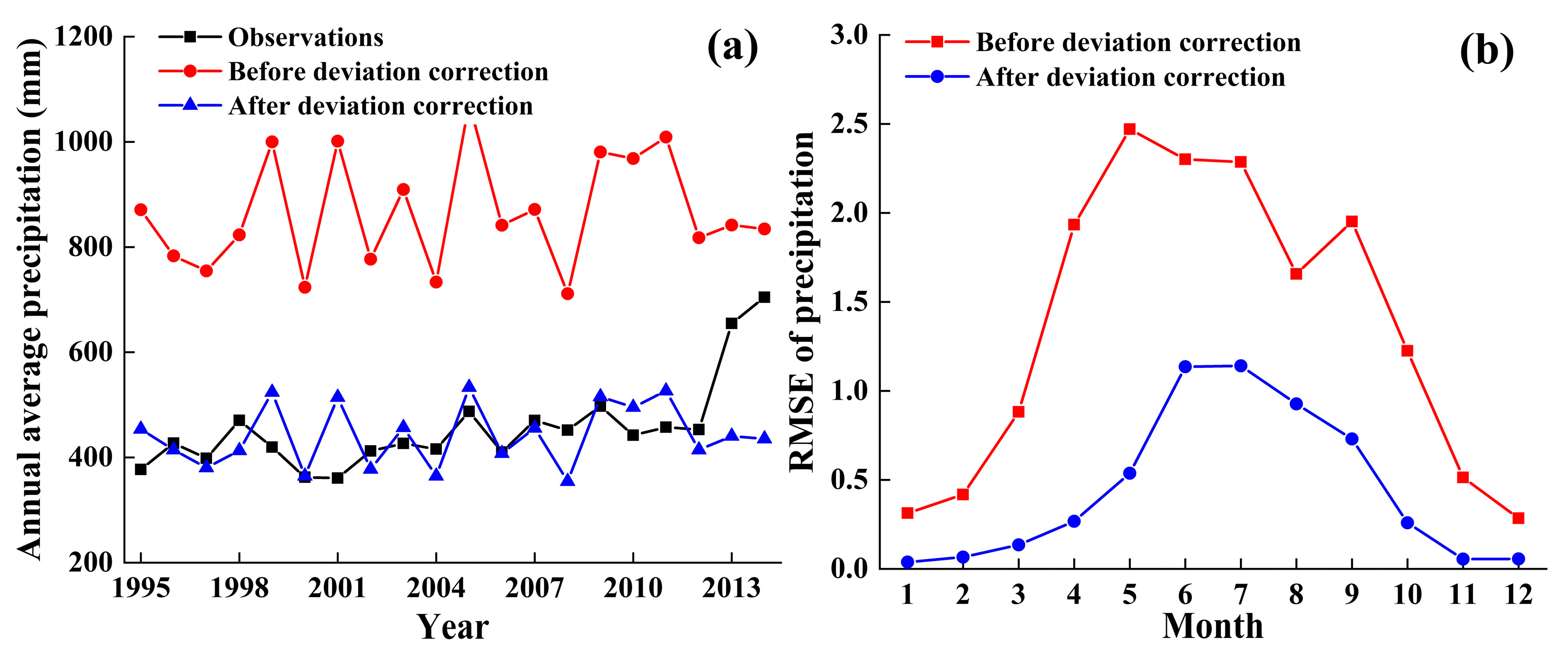
Figure 12a compares the annual average precipitation of MIROC6 before and after model deviation correction and the CN05.1 observation data set from 1995 to 2014. We found that the simulation results for MIROC6 significantly overestimated the precipitation. The simulated annual average precipitation from 1995 to 2014 was 866.3 mm before the MIROC6 model was revised and the observed annual average precipitation in CN05.1 was 455.0 mm in the Qinghai Lake Basin. After deviation correction, the average precipitation simulation value was 442.1 mm and the error was significantly reduced. Figure 12b compares the RMSE for each month before and after deviation correction. The simulation accuracy of MIROC6 improved from April to September; that is, the months with relatively high precipitation. In other months with less precipitation, the increase was small. In general, after deviation correction, the simulation errors of temperature and precipitation were significantly reduced, which laid a good foundation for the subsequent prediction of temperature and precipitation in the Qinghai Lake Basin.
Figure 13 shows the annual average temperature change trends of the three climate models from 2015 to 2100 in the Qinghai Lake Basin. The annual average temperature of the Qinghai Lake Basin showed an upward trend from 2015 to 2100, with the smallest increase in temperature under SSP1-2.6. The annual average temperature change of the Qinghai Lake Basin was forecast as approximately 0 °C near 2100. The average estimated temperature change of the three climate models was 0.14 °C from 2015 to 2100. The greatest increase in temperature was observed under SSP5-8.5, reaching about 4–8 °C in 2100. The simulated temperatures under the moderate forcing scenario were between those under the two scenarios mentioned above. Under SSP2-4.5, SSP3-7.0, and SSP5-8.5, the annual average temperature changes of the three climate models in Qinghai Lake Basin were 0.82, 1.32, and 2.09 °C, respectively. The temperature was significantly affected by the forcing scenario. The higher the forcing scenario, the higher the temperature. Because 2030 is expected to be the goal of peak carbon dioxide emissions, 2035 is the goal of the long-term planning of the Qinghai Lake Basin, and 2060 is the goal of carbon neutrality, the temperature under different forcing scenarios was extracted in 2030, 2035, and 2060 as typical years. Under the SSP1-2.6 scenario, the annual average temperature changes of the three models for 2030, 2035, and 2060 were 0.23, 0.53, and 1.10 °C, respectively. Under SSP2-4.5, the annual average temperature changes of the three models in three typical years were −0.36, 0.27, and 1.08 °C, respectively. Under SPS3-7.0, the annual average temperature changes of the three models were 0.21, 0.09, and 1.16 °C, respectively. Under SSP5-8.5, the annual average temperature changes of the three models were 0.68, 0.56, and 1.99 °C, respectively.
Figure 14 shows the annual average precipitation change trends for the three climate models from 2015 to 2100 in the Qinghai Lake Basin. We found that the annual average precipitation showed an overall upward trend compared to 1995–2014, but the increase was not as obvious as the increase in temperature. In the MIROC6 model, the average annual precipitation was 439.4 mm from 1995 to 2014 in the Qinghai Lake Basin. Under the four forcing scenarios, the average precipitation rose to 455.8–467.7 mm from 2015 to 2100, with an average increase of 16.4–28.3 mm. In MRI-ESM2, the annual average precipitation was 443.0 mm from 1995 to 2014 in the Qinghai Lake Basin, increasing to 470.8–491.3 mm in 2015–2100, with an average increase of 27.8–48.3 mm. In IPSL-CM6A-LR, the annual average precipitation was 441.7 mm between 1995 and 2014. The predicted annual average precipitation was 426.8–465.9 mm in 2015–2100, which decreased by 14.9 mm under SSP1-2.6 and increased by 16.5–24.2 mm on average under the other three forcing scenarios. Therefore, considering the overall precipitation process, the annual average precipitation showed a fluctuating upward trend in the Qinghai Lake Basin and was affected by the forcing scenario. However, the degree of influence was not as significant as that of the temperature. Under the SSP1-2.6 scenario, the annual average precipitation of the three models in 2030, 2035, and 2060 was 493.08, 426.76, and 463.93 mm, respectively. Under SSP2-4.5, the annual average precipitation of the three models in the three typical years was 398.07, 452.08, and 461.53 mm, respectively. Under SSP3-7.0, the annual average precipitation of the three models was 414.21, 473.20, and 446.86 mm, respectively. Under SSP5-8.5, the average annual precipitation of the three models was 531.49, 490.48, and 378.35 mm, respectively. The trend line formula for temperature and precipitation and the statistical results of the correlation coefficient are provided in the Supplementary Materials.
According to the results of historical observations, current simulations, and future predictions against the background of drastic climate change, the water level, precipitation, runoff, and temperature in the Qinghai Lake Basin showed obvious upward trends. The increase in precipitation was an important reason for the increase in runoff and water levels. The precipitation and temperature above Qinghai Lake were higher than those in other areas of the basin, which was mainly caused by the difference in the underlying surface. Therefore, a quantitative study of the impact of human activities on Qinghai Lake and its surrounding rivers is required. We integrated the impact of these two aspects and scientifically predicted the future change trends of temperature and precipitation in the Qinghai Lake Basin.

4. Discussion

The abnormal phenomena predicted under future climate change in the basin were analyzed. The precipitation in the Qinghai Lake Basin first increased rapidly and then slowly under the different emission scenarios of the MIROC6 model precipitation. Under the high-emissions scenario, precipitation increased slowly in the early stages and then increased significantly. This might be because the disturbance of the low-emission scenario to precipitation was relatively small. The fluctuation of precipitation in the high-emission scenario was relatively large, which had a stronger impact on the extreme value of precipitation.
Observational data were used in this study to verify the accuracy of the WRF simulation conclusions on the spatial distribution of meteorological elements during a typical summer period in the Qinghai Lake Basin. Comparing the temperature above Qinghai Lake with the observation results of nearby Gangcha and Tianjun meteorological stations, it was found that in August 2020, the monthly average temperatures above Qinghai Lake, Gangcha, and Tianjun meteorological stations near Qinghai Lake were 13.2, 11.2, and 10.1 °C, respectively, which also proved that the temperature above Qinghai Lake was higher than that in other regions. Comparing the precipitation in the Qinghai Lake area with the observation results of the nearby Buha Estuary hydrological station and Tianjun meteorological station, it was found that in August 2020, the monthly cumulative precipitation in the Qinghai Lake area was 117.7 mm. The monthly cumulative precipitation at the Buha and Tianjun stations was 60.8 and 66.8 mm, respectively. It is proved that the precipitation above Qinghai Lake was higher than that in the surrounding areas.
The impact of climate change on meteorological elements was analyzed in the Qinghai Lake Basin using observational data and climate models and spatial heterogeneity and temporal variation trends in temperature and precipitation were revealed. Although useful results were achieved in this study, owing to limited computing resources, the spatial distribution of the regional climate was only simulated in the most typical summer high-temperature and precipitation periods. In addition, human activities are becoming increasingly frequent in the Qinghai Lake Basin. Therefore, in the future, temperature and precipitation changes should be studied in more detail and in combination with data for other meteorological conditions and human activities.

5. Conclusions

Based on meteorological observation data, a regional climate model, and a global climate model, this study comprehensively analyzed the evolution law and development trend of meteorological and hydrological elements in the Qinghai Lake Basin. The main findings were as follows:
(1)
The Qinghai Lake Basin is significantly affected by climate change and its precipitation, runoff, and lake level have all increased to different degrees in recent years. The WRF model can simulate the spatial heterogeneity of summer temperature and precipitation in the Qinghai Lake Basin. In August 2020, the temperature and precipitation near Qinghai Lake were higher than those in the other regions of the basin. Temperature is mainly affected by altitude and underlying surface factors. Precipitation is mainly affected by underlying surface factors and temperature.
(2)
Against the background of drastic climate change, the predictions of future temperature and precipitation by the three climate models under the four forced scenarios showed an overall upward trend and were affected by the forced scenarios. Under the high forcing scenario, the annual average temperature predicted by the three climate models was 1.95 °C higher than that under the low forcing scenario in 2015–2100. The temperature was more significantly affected than the precipitation by the forcing scenario.
Climate change is a key factor that affects the transformation of hydrometeorological elements. The combined analysis of global and regional climate models can better explain the temporal and spatial distribution of meteorological elements in plateau lake basins, which can be applied to other lake regions worldwide.

Supplementary Materials

The following supporting information can be downloaded at: https://www.mdpi.com/article/10.3390/rs15184379/s1. Table S1: Trend line formula and correlation coefficient of future temperature change. Table S2: Trend line formula and correlation coefficient of future precipitation change.

Author Contributions

Methodology, Z.L. and S.Z.; formal analysis, L.Z.; conceptualization, J.L.; writing—original draft, Z.L.; writing—review and editing, J.L. and S.Z.; funding acquisition, J.L. and W.S.; investigation, L.Z.; software Z.L. and W.S.; supervision, J.L.; data curation, Z.L. and W.S. All authors have read and agreed to the published version of the manuscript.

Funding

This work was supported by Qinghai Province Key Research and Development and Transformation Program (2022-SF-143), Chinese National Key Research and Development Program (2022YFE0205200, 2022YFC3202000), the Fundamental Research Funds for the Central Universities (2023MS068).

Data Availability Statement

Remote sensing and elevation data were primarily derived from the Geospatial Data Cloud. The hydrometeor observation data used were derived from the Hydrology and Water Resources Forecast Center of Qinghai Province.

Conflicts of Interest

The authors declare no conflict of interest.

References

  1. Ba, W.; Du, P.; Liu, T.; Bao, A.; Chen, X.; Liu, J.; Qin, C. Impacts of climate change and agricultural activities on water quality in the Lower Kaidu River Basin, China. J. Geogr. Sci. 2020, 30, 164–176. [Google Scholar] [CrossRef]
  2. Biskaborn, B.K.; Smith, S.L.; Noetzli, J.; Matthes, H.; Vieira, G.; Streletskiy, D.A. Permafrost is warming at a global scale. Nat. Commun. 2019, 10, 264. [Google Scholar] [CrossRef]
  3. Lu, S.; Hu, Z.; Yu, H.; Fan, W.; Fu, C.; Wu, D. Changes of Extreme Precipitation and its Associated Mechanisms in Northwest China. Adv. Atmos. Sci. 2021, 38, 1665–1681. [Google Scholar] [CrossRef]
  4. Wu, J.; Miao, C.; Zhang, X.; Yang, T.; Duan, Q. Detecting the quantitative hydrological response to changes in climate and human activities. Sci. Total Environ. 2017, 586, 328–337. [Google Scholar] [CrossRef] [PubMed]
  5. Chen, C.; Hsu, H.; Liang, H. Evaluation and Comparison of CMIP6 and CMIP5 Model Performance in Simulating the Seasonal Extreme Precipitation in the Western North Pacific and East Asia. Weather Clim. Extrem. 2021, 31, 100303. [Google Scholar] [CrossRef]
  6. Gupta, V.; Singh, V.; Jain, M. Assessment of precipitation extremes in India during the 21st century under SSP1-1.9 mitigation scenarios of CMIP6 GCMs. J. Hydrol. 2020, 590, 125422. [Google Scholar] [CrossRef]
  7. Liu, J.; Zhang, Q.; Singh, V.; Shi, P. Contribution of multiple climatic variables and human activities to streamflow changes across China. J. Hydrol. 2017, 545, 145–162. [Google Scholar] [CrossRef]
  8. Wang, W.; Lee, X.; Xiao, W.; Liu, S.; Schultz, N.; Wang, Y.; Zhang, M.; Zhao, L. Global lake evaporation accelerated by changes in surface energy allocation in a warmer climate. Nat. Geosci. 2018, 11, 410–414. [Google Scholar] [CrossRef]
  9. Yao, J.; Chen, Y.; Guan, X.; Zhao, Y.; Chen, J.; Mao, W. Recent climate and hydrological changes in a mountain-basin system in Xinjiang, China. Earth-Sci. Rev. 2022, 226, 103957. [Google Scholar] [CrossRef]
  10. Luo, Z.; Liu, J.; Zhang, Y.; Zhou, J.; Shao, W.; Yu, Y.; Jia, R. Incorporating an urban canopy model with artificial water dissipation into weather research and forecasting: A case study for Beijing. Hydrol. Process. 2022, 36, e14523. [Google Scholar] [CrossRef]
  11. Rao, W.; Shen, Z.; Duan, X. Spatiotemporal patterns and drivers of soil erosion in Yunnan, Southwest China: RULSE assessments for recent 30 years and future predictions based on CMIP6. Catena 2023, 220, 106703. [Google Scholar] [CrossRef]
  12. Golroudbary, V.; Zeng, Y.; Mannaerts, C.; Su, Z. Response of Extreme Precipitation to Urbanization over the Netherlands. J. Appl. Meteorol. Clim. 2019, 58, 645–661. [Google Scholar] [CrossRef]
  13. Li, X.; Koh, T.; Panda, J.; Norford, L. Impact of urbanization patterns on the local climate of a tropical city, Singapore: An ensemble study. J. Geophys. Res. Atmos. 2016, 121, 4386–4403. [Google Scholar] [CrossRef]
  14. Luo, Z.; Liu, J.; Zhang, S.; Shao, W.; Zhou, J.; Zhang, L.; Jia, R. Spatiotemporal evolution of urban rain islands in China under the conditions of urbanization and climate change. Remote Sens. 2022, 14, 4159. [Google Scholar] [CrossRef]
  15. Zhang, Z.; Chang, J.; Xu, C.; Zhou, Y.; Wu, Y.; Chen, X.; Jiang, S.; Zheng, D. The response of lake area and vegetation cover variations to climate change over the Qinghai-Tibetan Plateau during the past 30 years. Sci. Total Environ. 2018, 635, 443–451. [Google Scholar] [CrossRef] [PubMed]
  16. Zhang, Z.; Qiu, J.; Cheng, T.; Huang, B.; Feng, Z. Urban flooding in the Guangdong-Hong Kong-Macao Greater Bay Area and its analysis. J. Hydraul. Eng. 2022, 53, 823–832. [Google Scholar] [CrossRef]
  17. Zahra, S.; Mahnoosh, M.; Shahla, P. Simultaneous Monitoring of Different Drought Types Using Linear and Nonlinear Combination Approaches. Water Resour. Manag. 2023, 37, 1125–1151. [Google Scholar] [CrossRef]
  18. Yang, M.; Lei, X.; Jiang, Y.; Wang, H.; He, S. Construction and application of precipitation collection forecast model in Qingshitan Reservoir. J. Hydraul. Eng. 2018, 49, 263–270. [Google Scholar] [CrossRef]
  19. Saha, U.; Sateesh, M. Rainfall extremes on the rise: Observations during 1951–2020 and bias-corrected CMIP6 projections for near- and late 21st century over Indian landmass. J. Hydrol. 2022, 608, 127682. [Google Scholar] [CrossRef]
  20. Luo, Z.; Liu, J.; Zhang, Y.; Zhou, J.; Shao, W.; Yu, Y.; Jia, R. Seasonal variation of dry and wet islands in Beijing considering urban artificial water dissipation. npj Clim. Atmos. Sci. 2021, 4, 58. [Google Scholar] [CrossRef]
  21. Singh, V.; Mohan, M.; Bhati, S. Industrial heat island mitigation in Angul-Talcher region of India: Evaluation using modified WRF-Single Urban Canopy Model. Sci. Total Environ. 2022, 858, 159949. [Google Scholar] [CrossRef] [PubMed]
  22. Kabano, P.; Harris, A.; Lindley, S. Spatiotemporal dynamics of urban climate during the wet-dry season transition in a tropical African city. Int. J. Biometeorol. 2022, 66, 385–396. [Google Scholar] [CrossRef] [PubMed]
  23. Luo, Z.; Liu, J.; Zhang, Y.; Zhou, J.; Yu, Y.; Jia, R. Spatiotemporal characteristics of urban dry/wet islands in China following rapid urbanization. J. Hydrol. 2021, 601, 126618. [Google Scholar] [CrossRef]
  24. Zhang, W.; Furtado, K.; Zhou, T.; Wu, P.; Chen, X. Constraining extreme precipitation projections using past precipitation variability. Nat. Commun. 2022, 13, 6319. [Google Scholar] [CrossRef]
  25. Cai, Y.; Ke, C.; Duan, Z. Monitoring ice variations in Qinghai Lake from 1979 to 2016 using passive microwave remote sensing data. Sci. Total Environ. 2017, 607, 120–131. [Google Scholar] [CrossRef]
  26. Fan, C.; Song, C.; Li, W.; Liu, K.; Wang, J. What drives the rapid water-level recovery of the largest lake (Qinghai Lake) of China over the past half century? J. Hydrol. 2021, 593, 125921. [Google Scholar] [CrossRef]
  27. Zhang, W.; Villarini, G.; Vecchi, G.; Smith, J. Urbanization exacerbated the rainfall and flooding caused by hurricane Harvey in Houston. Nature 2018, 563, 384–388. [Google Scholar] [CrossRef]
  28. Ma, Y.; Li, X.; Liu, L.; Yang, X.; Miao, C. Evapotranspiration and its dominant controls along an elevation gradient in the Qinghai Lake watershed, northeast Qinghai-Tibet Plateau. J. Hydrol. 2019, 575, 257–268. [Google Scholar] [CrossRef]
  29. Ma, Y.; Li, X.; Lei, L.; Huang, Y.; Zhou, L.; Xia, H.; Wu, X.; Yang, X.; Pei, W.; Zhao, S. Measurements and Modeling of the Water Budget in Semiarid High-Altitude Qinghai Lake Basin, Northeast Qinghai-Tibet Plateau. J. Geophys. Res. Atmos. 2018, 123, 10857–10871. [Google Scholar] [CrossRef]
  30. Li, Y.; Su, F.; Chen, D.; Tang, Q. Atmospheric Water Transport to the Endorheic Tibetan Plateau and Its Effect on the Hydrological Status in the Region. J. Geophys. Res. Atmos. 2020, 124, 12864–12881. [Google Scholar] [CrossRef]
  31. Tang, X.; Xie, G.; Deng, J.; Shao, K.; Hu, Y.; He, J.; Zhang, J.; Gao, G. Effects of climate change and anthropogenic activities on lake environmental dynamics: A case study in Lake Bosten Catchment, NW China. J. Environ. Manag. 2022, 319, 115764. [Google Scholar] [CrossRef]
  32. Luo, Z.; Liu, J.; Shao, W.; Zhou, J.; Jia, R. Distribution of dry and wet islands in the Pearl River Delta urban agglomeration using numerical simulations. Atmos. Res. 2022, 273, 106170. [Google Scholar] [CrossRef]
  33. Shikhovtsev, A.Y.; Kovadlo, P.G.; Lezhenin, A.A.; Korobov, O.A.; Kiselev, A.V.; Russkikh, I.V.; Kolobov, D.Y.; Shikhovtsev, M.Y. Influence of Atmospheric Flow Structure on Optical Turbulence Characteristics. Appl. Sci. 2023, 13, 1282. [Google Scholar] [CrossRef]
  34. Ma, H.; Cao, X.; Ma, X.; Su, H.; Jing, Y.; Zhu, K. Improving the Wind Power Density Forecast in the Middle- and High-Latitude Regions of China by Selecting the Relatively Optimal Planetary Boundary Layer Schemes. Atmosphere 2022, 13, 2034. [Google Scholar] [CrossRef]
  35. Li, C.; Ma, M.; Kou, W.; Zeng, X.; Cheng, W.; Wang, H.; Zhang, J.; Wang, W.; Lin, W.; Li, H.; et al. Substantial Near-Surface Spring Ozone Enhancement due to Stratospheric Intrusion in the Northeastern Qinghai-Tibet Plateau, China. Front. Environ. Sci. 2022, 10, 894937. [Google Scholar] [CrossRef]
  36. Zhang, Y.; Yan, D.; Wen, X.; Li, D.; Zheng, Z.; Zhu, X.; Wang, B.; Wang, C.; Wang, L. Comparative analysis of the meteorological elements simulated by different land surface process schemes in the WRF model in the Yellow River source region. Theor. Appl. Climatol. 2020, 139, 145–162. [Google Scholar] [CrossRef]
  37. Guo, Y.; Xu, Y.; Yu, X.; Xie, J.; Chen, H.; Si, Y. Impacts of GCM credibility on hydropower production robustness under climate change: CMIP5 vs CMIP6. J. Hydrol. 2023, 618, 129233. [Google Scholar] [CrossRef]
  38. Olmo, M.; Bettolli, M. Statistical downscaling of daily precipitation over southeastern South America: Assessing the performance in extreme events. Int. J. Climatol. 2021, 42, 1283–1302. [Google Scholar] [CrossRef]
  39. Zhang, Q.; Li, Y.; Huang, G.; Wang, H.; Li, Y.; Liu, Y.; Shen, Z. A novel statistical downscaling approach for analyzing daily precipitation and extremes under the impact of climate change: Application to an arid region. J. Hydrol. 2022, 615, 128730. [Google Scholar] [CrossRef]
  40. Lei, B.; Shi, C.; Li, L.; Yang, Y.; Wu, J. Accuracy of CHIRPS Satellite-Rainfall Products over China’s mainland. Remote Sens. 2018, 10, 362. [Google Scholar] [CrossRef]
  41. Ahmadi, H.; Rostami, N.; Dadashi, R. The impact of climate change on snowfall in Iran Basins using the satellite-derived snow products and CMIP6 Bias Corrected model. Theor. Appl. Climatol. 2022, 151, 603–618. [Google Scholar] [CrossRef]
Figure 1. (a) Geographical location and (b) water system and spatial distribution of observation stations of Qinghai Lake Basin.
Remotesensing 15 04379 g001
Figure 2. (a) Comparison of remote sensing images of Qinghai Lake Basin in 2021 (red) and 2004 (green), (b) display of areas with significant changes in Qinghai Lake.
Remotesensing 15 04379 g002
Figure 3. Three-layer nesting scheme of simulation area, D01, D02 and D03 are nested areas respectively.
Remotesensing 15 04379 g003
Figure 4. Main land use types in Qinghai Lake Basin and its surrounding area (D03 area), the black box represents the range of Qinghai Lake.
Remotesensing 15 04379 g004
Figure 5. The logical frame diagram of this study.
Remotesensing 15 04379 g005
Figure 6. Variation in annual average lake level from 1956 to 2020.
Remotesensing 15 04379 g006
Figure 7. Time series of interannual variation of precipitation.
Remotesensing 15 04379 g007
Figure 8. Variation of runoff with time in Qinghai Lake Basin.
Remotesensing 15 04379 g008
Figure 9. (a) The 2 m average temperature in August 2020 and (b) ground elevation of the simulation area. The color represents temperature (°C) and elevation (m) respectively, and the black box represents the range of Qinghai Lake.
Remotesensing 15 04379 g009
Figure 10. (a) Cumulative precipitation, (b) air-specific humidity, and (c) latent heat flux in the simulation area in August 2020. The color code represents precipitation (mm), specific humidity (g/kg), and latent heat flux values (W/m2), respectively.
Remotesensing 15 04379 g010
Figure 11. Comparison of (a) annual average temperature between the MIROC6 model deviation correction and CN05.1 observation values from 1995 to 2014 and (b) monthly root mean square error of temperature before and after deviation correction.
Remotesensing 15 04379 g011
Figure 12. (a) Annual average precipitation between the MIROC6 model bias correction and CN05.1 observation values from 1995 to 2014. (b) Comparison of monthly average root mean square error of precipitation before and after deviation correction.
Remotesensing 15 04379 g012
Figure 13. Annual average temperature change trend of (a) MIROC6, (b) MRI-ESM2, and (c) IPSL-CM6A-LR from 2015 to 2100.
Remotesensing 15 04379 g013
Figure 14. Annual average precipitation change trend process of (a) MIROC6, (b) MRI-ESM2, and (c) IPSL-CM6A-LR from 2015 to 2100.
Remotesensing 15 04379 g014
Table 1. Parameterization schemes of physical processes used in simulation experiments.
Physical ProcessParameterization Scheme
D01D02D03
Atmospheric Longwave RadiationRRTMRRTMRRTM
Shortwave RadiationDudhiaDudhiaDudhia
Planetary Boundary layerYSUYSUYSU
Land SurfaceNoahNoahNoah
MicrophysicsWSM 5WSM 5WSM 5
CumulusKFNoneNone
LakeNoneNoneOpen
Table 2. Brief introduction of the CMIP6 model used in this study.
NumberClimate ModelCountryHorizontal Resolution
1MIROC6Japan1.4° × 1.4°
2IPSL-CM6A-LRFrance2.5° × 1.3°
3MRI-ESM2-0Japan1.1° × 1.1°
Disclaimer/Publisher’s Note: The statements, opinions and data contained in all publications are solely those of the individual author(s) and contributor(s) and not of MDPI and/or the editor(s). MDPI and/or the editor(s) disclaim responsibility for any injury to people or property resulting from any ideas, methods, instructions or products referred to in the content.