
Furthering Automatic Feature Extraction for Fit-for-Purpose Cadastral Updating: Cases from Peri-Urban Addis Ababa, Ethiopia

 ,
,  , and
, and 
Abstract
:1. Introduction
1.1. Fit-for-Purpose Cadastral Mapping to Accelerate the Implementation of FFPLA
1.2. Urbanization, a Threat to Tenure Security of Peri-Urban Areas of Addis Ababa
1.3. AFE Practices for Mapping Cadastral Boundaries
1.4. Objective and Structure of the Study
2. Methods and Materials
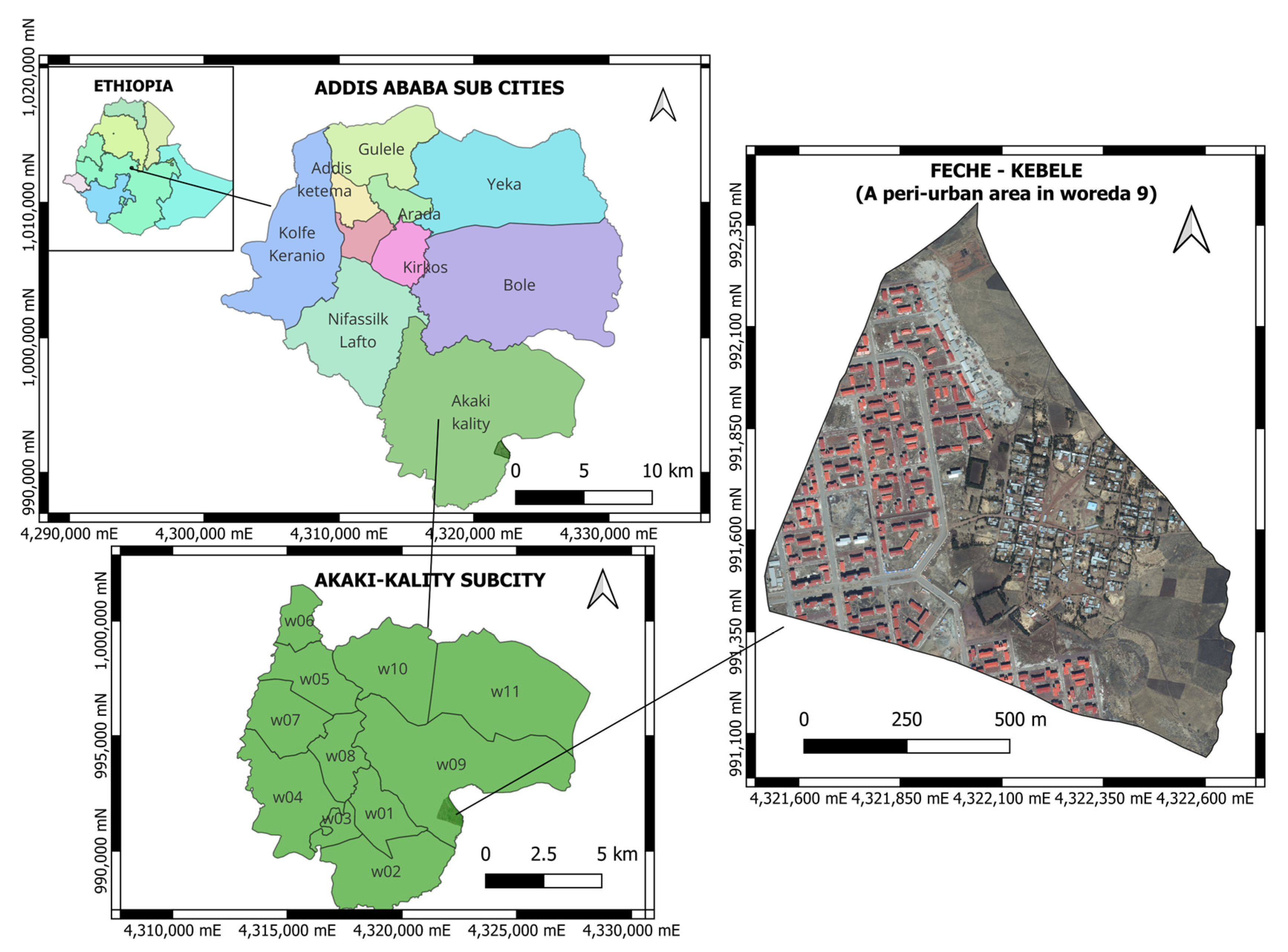
2.1. Study Area
2.2. Data
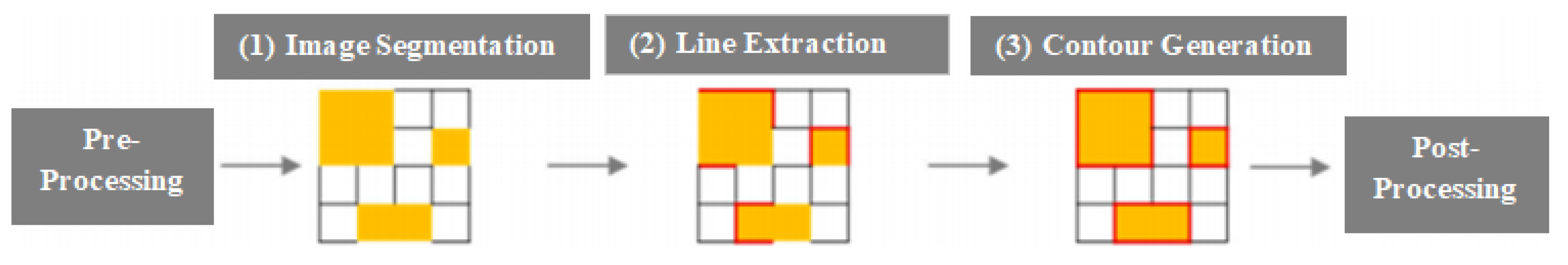
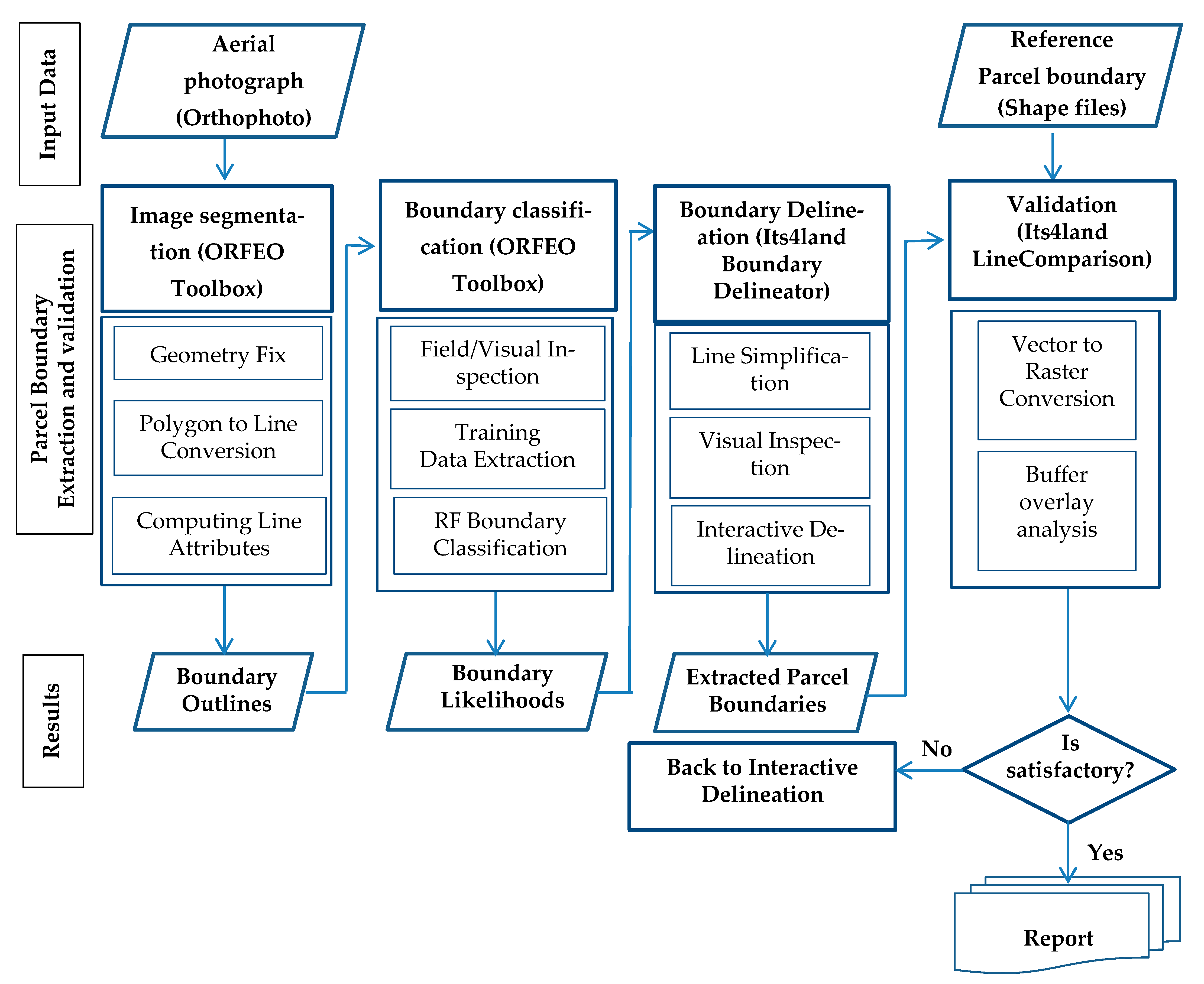
2.3. AFE Implementation
- (i)
- Image segmentation: at this stage, the orthoimage pixels are grouped into segments to deliver the outlines of the visible boundary features. This study employs the mean-shift image segmentation algorithm implemented in Orfeo ToolBox (https://www.orfeo-toolbox.org/, accessed on 9 January 2023) (OTB), an open-source state-of-the-art image processing library freely available for use [61,62]. The OTB is integrated into QGIS Version 3.16.0 for ease of use and further analysis of the extracted parcel boundaries.
- (ii)
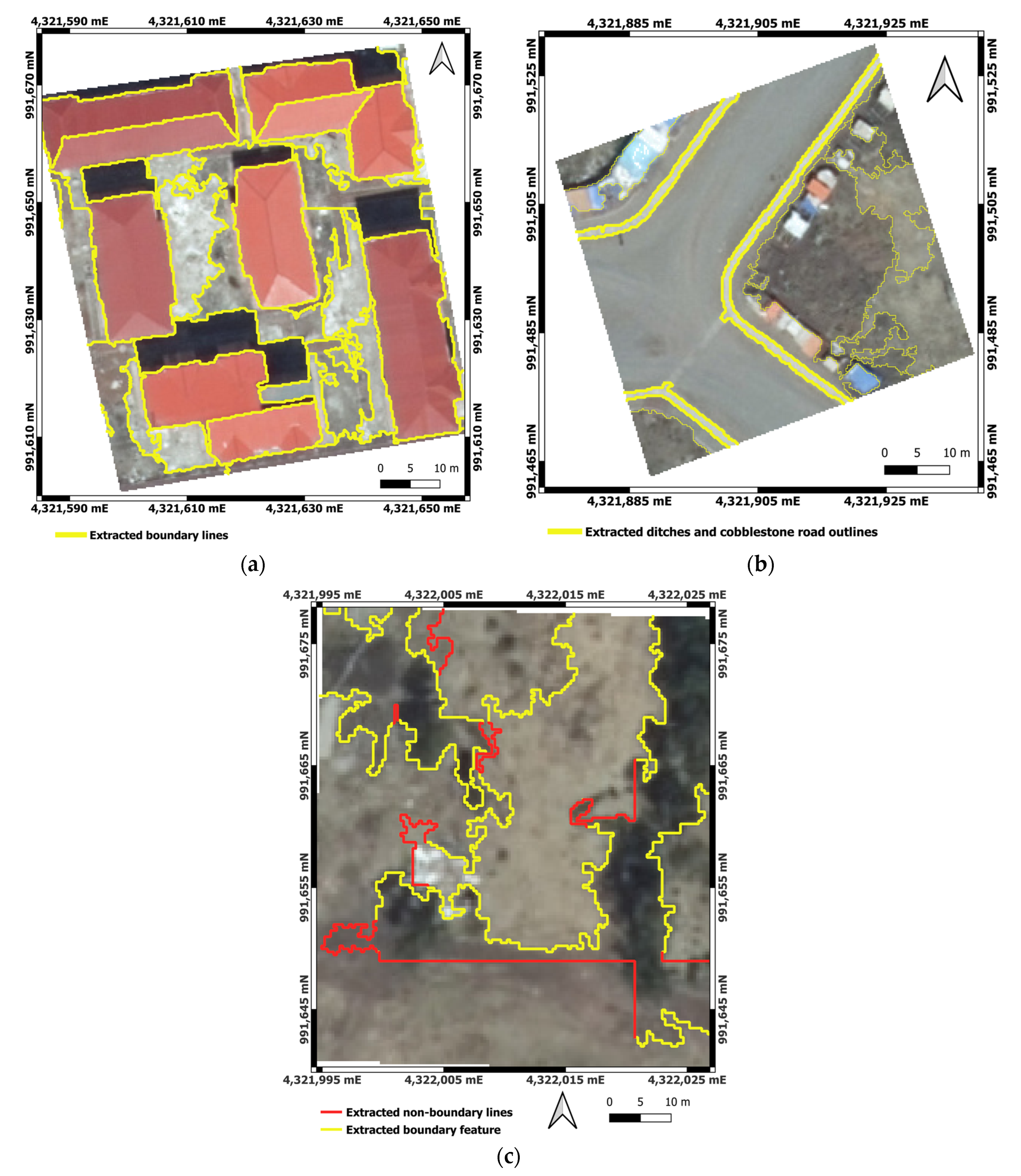
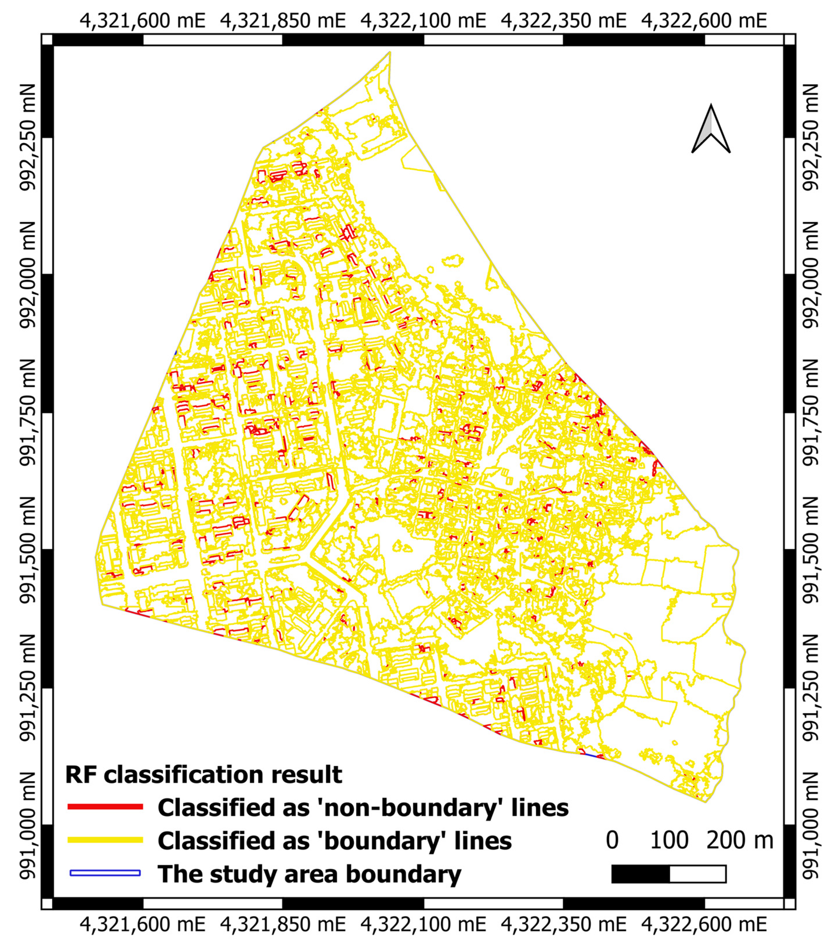
- Boundary classification: this step requires training a machine-learning model with a training dataset to enable it to predict the most probable boundary lines from the vector files obtained through image segmentation. The training and validation datasets are extracted from the segmentation result by manually selecting and assigning 1 and 0 attribute values, respectively, to the boundary and non-boundary line features. This study applied Random Forest (RF) machine-learning algorithms for parcel boundary prediction. Although Crommelinck et al. [51] tested and found that Convolutional Neural Network (CNN) machine-learning algorithms provide better precision and accuracy in boundary likelihoods, various studies have also proven that RF could provide good accuracy in image classification [2,63,64]. Moreover, it is one of several machine-learning models implemented in the OTB.
- (iii)
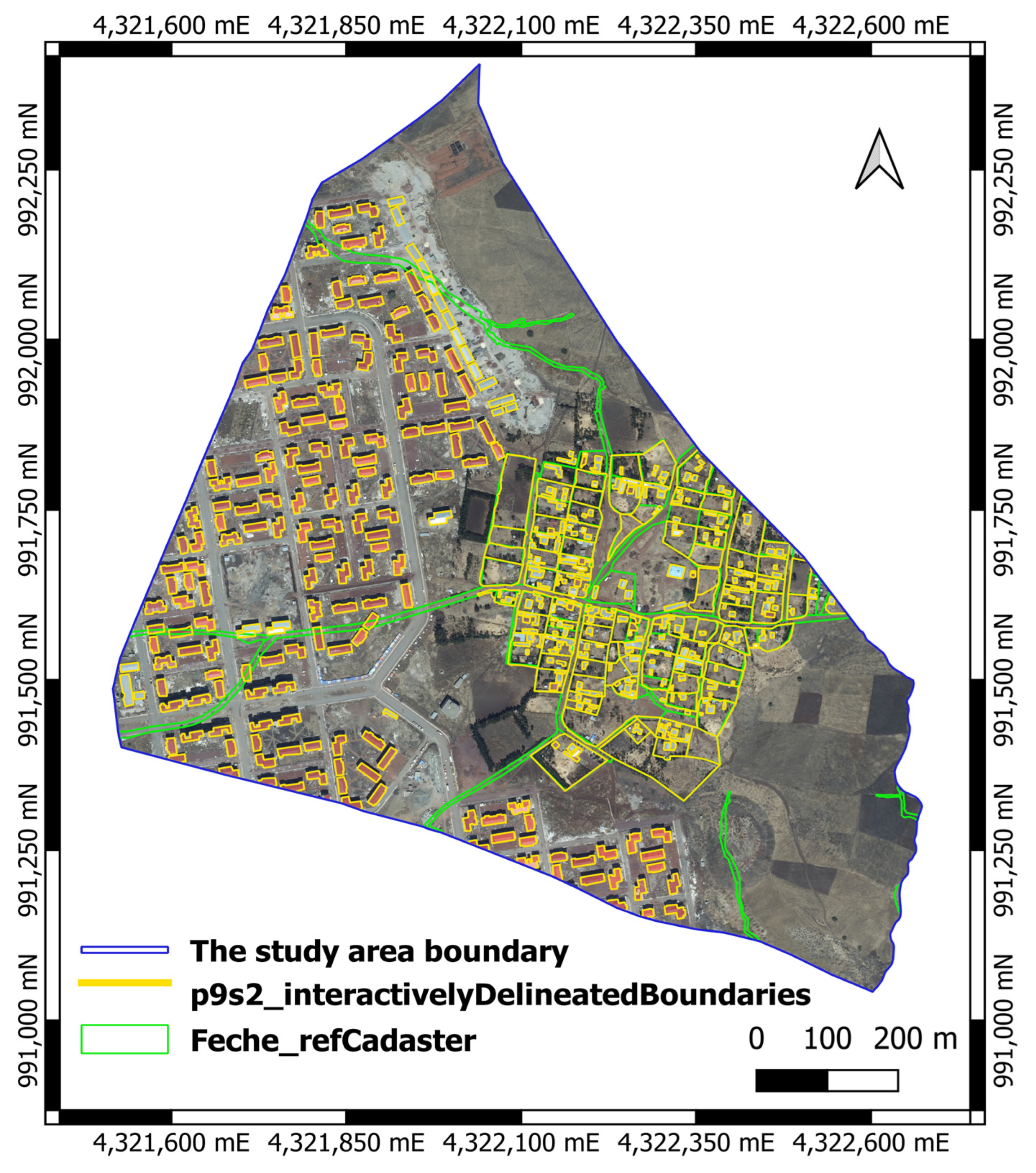
- Interactive delineation: at this stage, the final cadastral boundaries are created by interactively delineating the boundary outlines based on the classification result. The line segments classified as parcel boundaries were further visually inspected and interactively delineated using the QGIS Version 3.16.0 “BoundaryDelineation” plugin. The plugin is developed by the Its4land (https://Its4land.com/, accessed on 29 September 2022) initiative, a European Horizon 2020-funded project, for quick cadastral mapping and land rights registration [65]. It is one of the six tools created by the initiative to support Sub-Saharan African countries with innovative technologies and consulting services in order to improve the time- and cost-consuming field surveying procedure for cadastral mapping. The plugin is supposed to expedite the interactive delineation process and minimize human resources and infrastructure costs [66,67]. It is also thought to enhance cadastral mapping where visible cadastral boundaries are predominant and fit-for-purpose land administration is favored [68]. Although it needs further investigation to refine the plugin [14,51], Crommelinck et al. [69] have suggested applying the technology for real-world cadastral mapping scenarios.

| Functionality | Description |
|---|---|
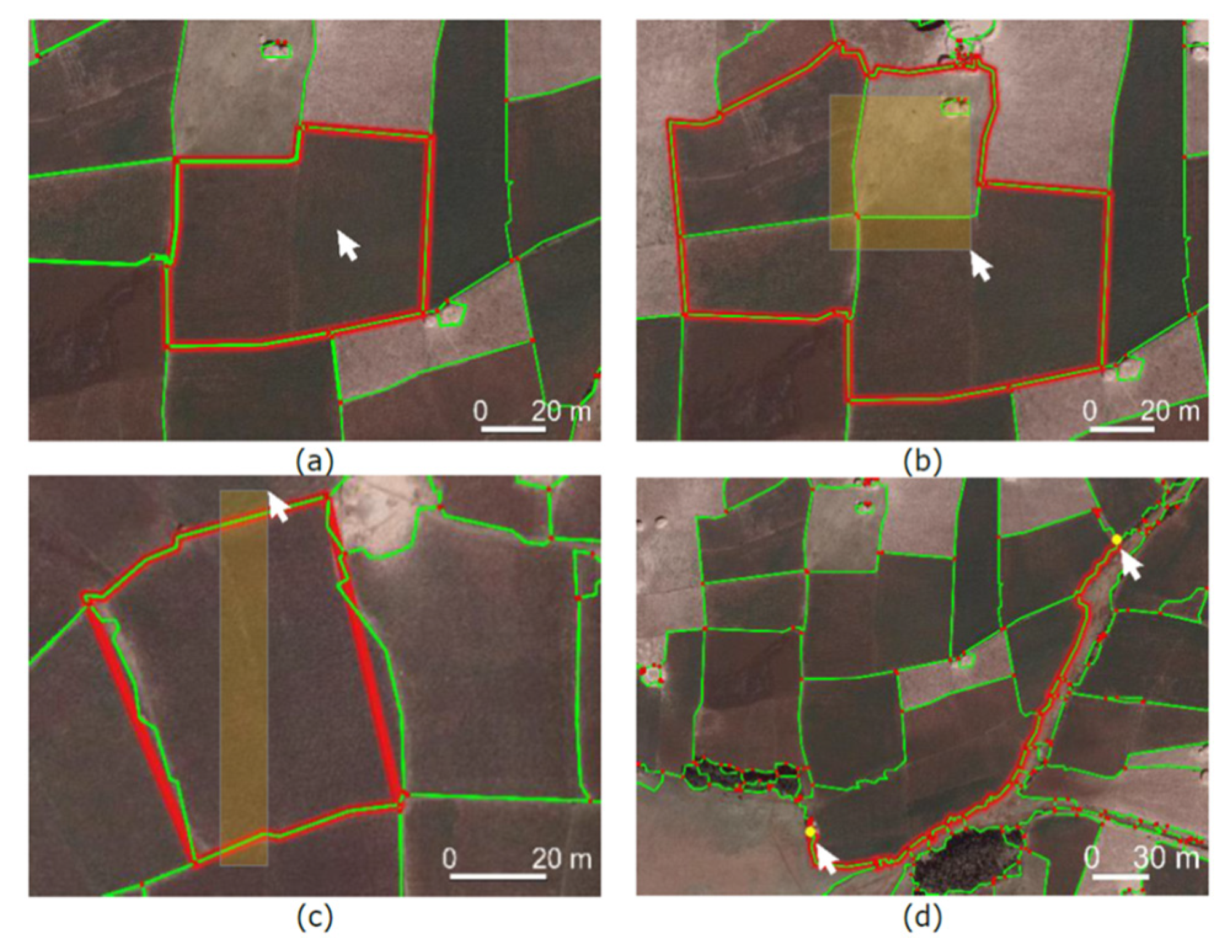
| Connect around selection | Connects lines surrounding a click or selection of lines (Figure 4a,b) |
| Connect lines’ end points | Connects endpoints of selected lines to a polygon regardless of the segmentation lines (Figure 4c) |
| Connect along optimal path | Connects vertices along least-cost-path based on a selected attribute, e.g., Boundary likelihood (Figure 4d) |
| Connect manual clicks | Manual delineation with the option to snap to input lines and vertices |
| Update edits | Updates input lines based on manual edits |
| Polygonize results | Converts created boundary lines to polygons |
2.4. Accuracy Assessment
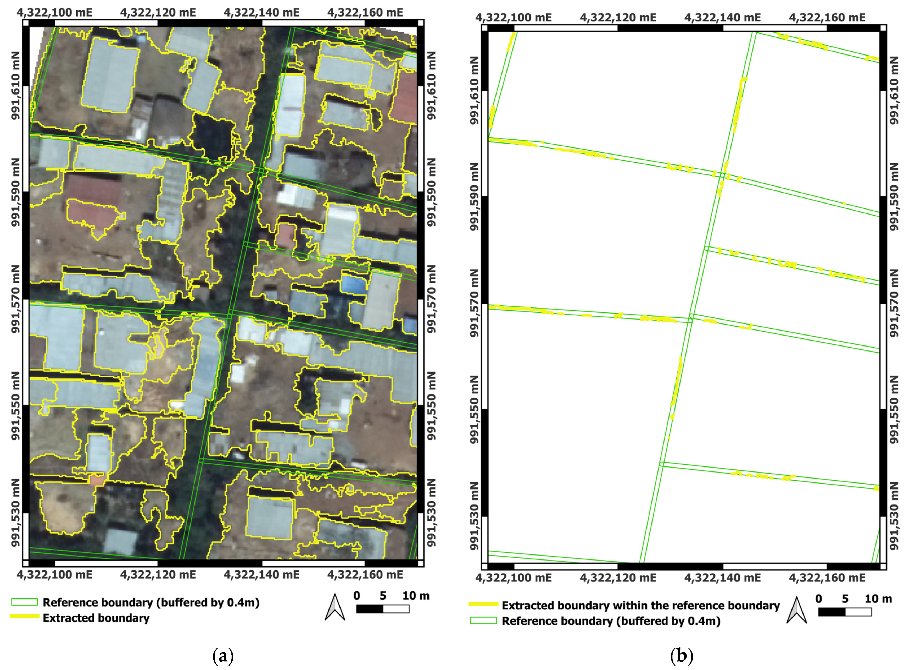
- Completeness is the percentage of the reference boundary that lies within the buffered extracted data (the reference data explained by the extracted data) and is given as
- Correctness refers the percentage of the extracted boundary that lies within the buffered reference data (the extracted data explained by the reference data), and is given as
- Quality is derived from the completeness and correctness of the extracted data, for these two metrics are complimentary and computed concurrently in order to indicate the quality or the overall accuracy of the extraction approach [76].
3. Results
3.1. Image Segmentation
3.2. Boundary Classification
3.3. Interactive Delineation
3.4. Validation
4. Discussion
4.1. Image Segmentation and Classification Contribute to Cadastral Mapping
4.2. Interactive Delineation Enhances the Traditional On-Screen Digitization
4.3. Open-Source Software Tools and Plugins Streamlined the AFE Approach for Cadastral Mapping
5. Conclusions
Author Contributions
Funding
Institutional Review Board Statement
Informed Consent Statement
Data Availability Statement
Conflicts of Interest
Abbreviations
| UAVs | Unmanned Aerial Vehicles |
| GPS | Global Positioning System |
| GNSS | Global Navigation Satellite System |
| FFPLA | Fit-for-purpose land administration |
| OBIA | Object-Based Image Analysis |
| GIS | Geographic Information System |
| MCG | Multi-resolution Combinational Grouping |
| gPb | globalized probability of boundary |
| QGIS | Quantum GIS |
| OTB | Orfeo ToolBox |
| RF | Random Forest |
| CNN | Convolutional Neural Network |
| FDRE | Federal Democratic Republic of Ethiopia |
| IAAO | International Association of Assessing Officers |
References
- Woodcock, C.E.; Strahler, A.H.; Franklin, J. Remote sensing for land management and planning. Environ. Manag. 1983, 7, 223–237. [Google Scholar] [CrossRef]
- Koeva, M.; Stöcker, C.; Crommelinck, S.; Ho, S.; Chipofya, M.; Sahib, J.; Bennett, R.; Zevenbergen, J.; Vosselman, G.; Lemmen, C. Innovative remote sensing methodologies for Kenyan land tenure mapping. Remote Sens. 2020, 12, 273. [Google Scholar] [CrossRef]
- Šafář, V.; Potůčková, M.; Karas, J.; Tlustý, J.; Štefanová, E.; Jančovič, M.; Cígler Žofková, D. The Use of UAV in Cadastral Mapping of the Czech Republic. ISPRS Int. J. Geo-Inf. 2021, 10, 380. [Google Scholar] [CrossRef]
- Fetai, B.; Oštir, K.; Kosmatin Fras, M.; Lisec, A. Extraction of visible boundaries for cadastral mapping based on UAV imagery. Remote Sens. 2019, 11, 1510. [Google Scholar] [CrossRef]
- Nyandwi, E.; Koeva, M.; Kohli, D.; Bennett, R. Comparing human versus machine-driven cadastral boundary feature extraction. Remote Sens. 2019, 11, 1662. [Google Scholar] [CrossRef]
- Enemark, S.; Lemmen, C.; Bell, K.C.; McLaren, R. Fit-For-Purpose Land Administration; Joint FIG/World Bank Publication: Copenhagen, Denmark, 2014. [Google Scholar]
- Enemark, S.; McLaren, R.; Lemmen, C. Fit-For-Purpose Land Administration Guiding Principles; Global Land Tool Network (GLTN): Copenhagen, Denmark, 2015. [Google Scholar]
- Teklemariam, A.T.; Cochrane, L. The rush to the peripheries: Land rights and tenure security in peri-urban Ethiopia. Land 2021, 10, 193. [Google Scholar] [CrossRef]
- Biraro, M.; Zevenbergen, J.; Alemie, B.K. Good practices in updating land information systems that used unconventional approaches in systematic land registration. Land 2021, 10, 437. [Google Scholar] [CrossRef]
- Krigsholm, P.; Riekkinen, K.; Ståhle, P. The changing uses of cadastral information: A user-driven case study. Land 2018, 7, 83. [Google Scholar]
- Lin, L.; Zhang, C. Land parcel identification. In Agro-Geoinformatics: Theory and Practice; Springer Nature: London, UK, 2021; pp. 163–174. [Google Scholar]
- Crommelinck, S.; Bennett, R.; Gerke, M.; Nex, F.; Yang, M.Y.; Vosselman, G. Review of automatic feature extraction from high-resolution optical sensor data for UAV-based cadastral mapping. Remote Sens. 2016, 8, 689. [Google Scholar] [CrossRef]
- Kaufmann, J. The boundary concept: Land management opportunities for sustainable development provided by the cadastre 2014 approach. In FIG Working Week; FIG: Stockholm, Sweden, 2008. [Google Scholar]
- Zevenbergen, J.; Bennett, R. The visible boundary: More than just a line between coordinates. In Proceedings of the GeoTechRwanda, Kigali, Rwanda, 8–20 November 2015; pp. 17–25. [Google Scholar]
- Grant, D.; Enemark, S.; Zevenbergen, J.; Mitchell, D.; McCamley, G. The Cadastral triangular model. Land Use Policy 2020, 97, 104758. [Google Scholar] [CrossRef]
- Wassie, Y.A.; Koeva, M.N.; Bennett, R.M.; Lemmen, C.H.J. A procedure for semi-automated cadastral boundary feature extraction from high-resolution satellite imagery. J. Spat. Sci. 2017, 63, 75–92. [Google Scholar] [CrossRef]
- Zahir, A.; Ahmed, S. Extracting parcel boundaries from satellite imagery for a Land Information System. In Proceedings of the 2013 6th International Conference on Recent Advances in Space Technologies (RAST), Istanbul, Turkey, 12–14 June 2013; pp. 79–81. [Google Scholar]
- Kohli, D.; Unger, E.; Lemmen, C.; Bennett, R.; Koeva, M.; Friss, J.; Bhandari, B. Validation of a cadastral map created using satellite imagery and automated feature extraction techniques: A case of Nepal. In Proceedings of the XXVI FIG Congress 2018: Embracing Our Smart World Where the Continents Connect: Enhancing the Geospatial Maturity of Societies, Istanbul, Turkey, 6–11 May 2018; International Federation of Surveyors (FIG): Copenhagen, Denmark. [Google Scholar]
- Chandrarathna, G. Comparative Study on Cadastral Surveying Using Total Station and High Resolution UAV Image (HRUAVI); Institute of Surveying and Mapping (Diyatalawa), Suvey Department: Diyatalawa, Sri Lanka, 2016.
- Yagol, P.; Shrestha, E.; Thapa, L.; Poudel, M.; Bhatta, G.P. Comparative study on cadastral surveying using total station and high resolution satellite image. In Proceedings of the FIG-ISRPS Workshop, Kathamandu, Nepal, 25–27 November 2015. [Google Scholar]
- Bennett, R.M.; Unger, E.-M.; Lemmen, C.; Dijkstra, P. Land administration maintenance: A review of the persistent problem and emerging fit-for-purpose solutions. Land 2021, 10, 509. [Google Scholar]
- Enemark, S.; Mclaren, R.; Lemmen, C. Fit-for-Purpose Land Administration: Guiding Principles for Country Implementation; World Bank Publications: Herndon, VA, USA, 2016. [Google Scholar]
- Adam, A.G. Understanding competing and conflicting interests for peri-urban land in Ethiopia’s era of urbanization. Environ. Urban. 2020, 32, 55–68. [Google Scholar] [CrossRef]
- Adam, A.G. Urban built-up property formation process in the peri-urban areas of Ethiopia. In Land Use Change and Sustainability; IntechOpen: London, UK, 2020. [Google Scholar]
- Wubie, A.M.; de Vries, W.T.; Alemie, B.K. Synthesizing the dilemmas and prospects for a peri-urban land use management framework: Evidence from Ethiopia. Land Use Policy 2021, 100, 105122. [Google Scholar]
- Tesfaye, E.K. Peri-Urban Land in Ethiopia: Genesis, Dynamics and Planning. Ph.D. Thesis, Universität Rostock, Rostock, Germany, 2019. Available online: https://www.uni-rostock.de/storages/uni-rostock/Alle_AUF/AUF/PDFs/Thesen/2019/Thesen_Eshetayehu_Kinfu_Tesfaye.pdf (accessed on 22 March 2023).
- Larsen, L.; Yeshitela, K.; Mulatu, T.; Seifu, S.; Desta, H. The impact of rapid urbanization and public housing development on urban form and density in Addis Ababa, Ethiopia. Land 2019, 8, 66. [Google Scholar] [CrossRef]
- Mohammed, I.; Kosa, A.; Juhar, N. Economic linkage between urban development and livelihood of peri-urban farming communities in Ethiopia (policies and practices). Agric. Food Econ. 2020, 8, 21. [Google Scholar] [CrossRef]
- World Bank Group. Ethiopia Urbanization Review: Urban Institutions for a Middle-Income Ethiopia; World Bank Group: Washington, DC, USA, 2015; Available online: https://openknowledge.worldbank.org/handle/10986/22979 (accessed on 20 May 2022).
- Wubneh, M. Addis Ababa, Ethiopia–Africa’s diplomatic capital. Cities 2013, 35, 255–269. [Google Scholar]
- van der Molen, P. CADASTRE 2014: A beacon in turbulent times. In Proceedings of the FIG Congress 2014—Engaging the Challenges—Enhancing the Relevance, Kuala Lumpur, Malaysia, 16–21 June 2014. [Google Scholar]
- Yehun, A.; Reda, A.; Mekonen, A.; Chekole, S. Evaluation of current urban cadastre practice in Ethiopia: Case of Bahir Dar, Gondar, and Dessie. In Proceedings of the FIG Working Week 2017. Surveying the World of Tomorrow—From Digitalisation to Augmented Reality, Helsinki, Finland, 29 May–2 June 2017. [Google Scholar]
- Alemie, B.K.; Bennett, R.M.; Zevenbergen, J. Evolving urban cadastres in Ethiopia: The impacts on urban land governance. Land Use Policy 2015, 42, 695–705. [Google Scholar] [CrossRef]
- Yehun, A.; Reda, A.; Mokonen, A.; Chekole, S. Evaluation of Current Urban Cadaster Practice in Ethiopia: Case of Bahir Dar, Gondar & Dessie. In FIG Working Week; The World Bank: Washington, DC, USA, 2012. [Google Scholar]
- Zein, T.; Hartfiel, P.; Berisso, Z.A. Addis Ababa: The road map to progress through securing property rights with real property registration system. In Proceedings of the World Bank Conference on Land and Poverty, Washington, DC, USA, 23–26 April 2012; pp. 23–26. [Google Scholar]
- Deininger, K.; Ali, D.A.; Holden, S.; Zevenbergen, J. Rural land certification in Ethiopia: Process, initial impact, and implications for other African countries. World Dev. 2008, 36, 1786–1812. [Google Scholar] [CrossRef]
- Chekole, S.D.; de Vries, W.T.; Shibeshi, G.B. An evaluation framework for urban cadastral system policy in Ethiopia. Land 2020, 9, 60. [Google Scholar] [CrossRef]
- Tadesse, D. Reflections on the situation of urban cadaster in Ethiopia. In Proceedings of the Municipal Development Partnership (Eastern and Southern Africa) Africa Local Government Action Forum (ALGAF) Phase VI, Addis Ababa, Ethiopia, 7 April 2006. [Google Scholar]
- Tigistu, G. Experience and future direction in Ethiopian rural land administration. In Proceedings of the Annual World Bank Conference on Land and Property, Washington, DC, USA, 23–26 April 2011; pp. 19–20. [Google Scholar]
- Metaferia, M.T.; Bennett, R.M.; Alemie, B.K.; Koeva, M. The peri-urban cadastre of Addis Ababa: Status, challenges, and fit-for-purpose prospects. Land Use Policy 2023, 125, 106477. [Google Scholar] [CrossRef]
- FAO; IFAD. GeoTech4Tenure-Technical Guide on Combining Geospatial Technology and Participatory Methods for Securing Tenure Rights; FAO: Rome, Italy, 2022. [Google Scholar] [CrossRef]
- Mather, P.; Tso, B. Classification Methods for Remotely Sensed Data, 2nd ed.; CRC Press: Boca Raton, FL, USA, 2009. [Google Scholar]
- Thakur, V.; Doja, M.; Ahmad, T.; Rawat, R. Cadastral boundary extraction and image classification using OBIA and machine learning for National Land Records Modernization Programme in India. J. Remote Sens. GIS 2019, 8, 7. [Google Scholar]
- Musleh, A.A.; Jaber, H.S. Comparative analysis of feature extraction and pixel-based classification of high-resolution satellite images using geospatial techniques. E3S Web Conf. 2021, 318, 04007. [Google Scholar] [CrossRef]
- Fetai, B.; Grigillo, D.; Lisec, A. Revising cadastral data on land boundaries using deep learning in image-based mapping. ISPRS Int. J. Geo-Inf. 2022, 11, 298. [Google Scholar] [CrossRef]
- Christiaan, L.; Rohan, B.; Robin, M.; Stig, E. A New Era in Land Administration Emerges. GIM Int. 2015, 29, 22–25. [Google Scholar]
- Babawuro, U.; Beiji, Z. Satellite imagery cadastral features extractions using image processing algorithms: A viable option for cadastral science. Int. J. Comput. Sci. Issues 2012, 9, 30–38. [Google Scholar]
- Turker, M.; Kok, E.H. Field-based sub-boundary extraction from remote sensing imagery using perceptual grouping. ISPRS J. Photogramm. Remote Sens. 2013, 79, 106–121. [Google Scholar] [CrossRef]
- Crommelinck, S.C. Automating Image-Based Cadastral Boundary Mapping. Ph.D. Thesis, University of Twente, Faculty of Geo-Information Science and Earth Observation (ITC), Enschede, The Netherlands, 2019. Available online: https://research.utwente.nl/en/publications/automating-imagebased-cadastral-boundary-mapping(8165a0ca-be6f-4cdf-b89e-f403af9304dc).html (accessed on 7 February 2023).
- Koeva, M.; Humayun, M.I.; Timm, C.; Stöcker, C.; Crommelinck, S.; Chipofya, M.; Bennett, R.; Zevenbergen, J. Geospatial tool and geocloud platform innovations: A fit-for-purpose land administration assessment. Land 2021, 10, 557. [Google Scholar] [CrossRef]
- Crommelinck, S.; Koeva, M.; Yang, M.Y.; Vosselman, G. Application of deep learning for delineation of visible cadastral boundaries from remote sensing imagery. Remote Sens. 2019, 11, 2505. [Google Scholar] [CrossRef]
- Molendijk, M.; Guarin, J.M.; Lemmen, C. Light mobile collection tools for land administration: Proof of concept from Colombia. GIM Int. 2015, 27, 20–23. [Google Scholar]
- Weldeghebrael, E.H. Addis Ababa: City Scoping Study; African Cities Research Consortium, The University of Manchester: Manchester, UK, 2021; Available online: https://www.african-cities.org (accessed on 12 February 2023).
- Nasser, N. The Socio-Economic Impact of Addis Ababa City Expansion on Farmers: The Case of Akaki Kality Sub City. Master’s Thesis, Addis Ababa University, Addis Ababa, Ethiopia, 2020. Available online: http://etd.aau.edu.et/handle/123456789/22139?show=full (accessed on 15 February 2023).
- Koroso, N.H.; Zevenbergen, J.A.; Lengoiboni, M. Urban land use efficiency in Ethiopia: An assessment of urban land use sustainability in Addis Ababa. Land Use Policy 2020, 99, 105081. [Google Scholar] [CrossRef]
- Terfa, B.K.; Chen, N.; Liu, D.; Zhang, X.; Niyogi, D. Urban expansion in Ethiopia from 1987 to 2017: Characteristics, spatial patterns, and driving forces. Sustainability 2019, 11, 2973. [Google Scholar] [CrossRef]
- Mohamed, A.; Worku, H.; Lika, T. Urban and regional planning approaches for sustainable governance: The case of Addis Ababa and the surrounding area changing landscape. City Environ. Interact. 2020, 8, 100050. [Google Scholar] [CrossRef]
- Mohamed, A.; Worku, H. Quantification of the land use/land cover dynamics and the degree of urban growth goodness for sustainable urban land use planning in Addis Ababa and the surrounding Oromia special zone. J. Urban Manag. 2019, 8, 145–158. [Google Scholar] [CrossRef]
- Tufa, D.E.; Megento, T.L. The effects of farmland conversion on livelihood assets in peri-urban areas of Addis Ababa Metropolitan city, the case of Akaki Kaliti sub-city, Central Ethiopia. Land Use Policy 2022, 119, 106197. [Google Scholar] [CrossRef]
- Crommelinck, S.; Ivanov, I. Delineation-Tool Wiki. GitHub Repository. Available online: https://github.com/its4land/delineation-tool/wiki (accessed on 15 November 2022).
- Michel, J.; Grizonnet, M. State of the Orfeo Toolbox. In Proceedings of the 2015 IEEE International Geoscience and Remote Sensing Symposium (IGARSS), Milan, Italy, 26–31 July 2015; pp. 1336–1339. [Google Scholar]
- Orfeo ToolBox. Open Source Processing of Remote Sensing Images. Available online: https://www.orfeo-toolbox.org/ (accessed on 9 January 2023).
- Oo, T.K.; Arunrat, N.; Sereenonchai, S.; Ussawarujikulchai, A.; Chareonwong, U.; Nutmagul, W. Comparing four machine learning algorithms for land cover classification in gold mining: A case study of Kyaukpahto Gold Mine, Northern Myanmar. Sustainability 2022, 14, 10754. [Google Scholar] [CrossRef]
- Uddin, S.; Khan, A.; Hossain, M.E.; Moni, M.A. Comparing different supervised machine learning algorithms for disease prediction. BMC Med. Inform. Decis. Mak. 2019, 19, 281. [Google Scholar] [CrossRef]
- Its4land. What Is Its4land All about? Available online: https://its4land.com/ (accessed on 29 September 2022).
- Crommelinck, S.; Koeva, M.; Yang, M.Y.; Vosselman, G. Robust object extraction from remote sensing data. arXiv 2019, arXiv:1904.12586. [Google Scholar]
- Crommelinck, S.; Koeva, M. Towards Cadastral Intelligence? GIM Int. 2019, 27–29. [Google Scholar]
- Crommelinck, S.; Yang, M.Y.; Koeva, M.; Gerke, M.; Bennett, R.; Vosselman, G. Towards Automated Cadastral Boundary Delineation from UAV data. arXiv 2017, arXiv:1709.01813. [Google Scholar]
- Crommelinck, S.; Höfle, B.; Koeva, M.; Yang, M.; Vosselman, G. Interactive cadastral boundary delineation from UAV data. ISPRS Ann. Photogramm. Remote Sens. Spat. Inf. Sci. 2018, 4, 81–88. [Google Scholar] [CrossRef]
- Goodchild, M.F.; Hunter, G. A simple positional accuracy measure for linear features. Int. J. Geogr. Inf. Sci. 1997, 11, 299–306. [Google Scholar] [CrossRef]
- Heipke, C.; Mayer, H.; Wiedemann, C.; Jamet, O. Evaluation of automatic road extraction. Int. Arch. Photogramm. Remote Sens. 1997, 32, 151–160. [Google Scholar]
- Zein, T. Fit-For-Purpose Land Administration: An implementation model for cadastre and land administration systems. In Proceedings of the 2016 World Bank Conference on Land and Poverty, Washington, DC, USA, 14–18 March 2016. [Google Scholar]
- FDRE. Regulation to Provide for Urban Cadastral Surveying Council of Ministers Regulation (323/2014); Federal Democratic Republic of Ethiopia, Federal Negarit Gazeta: Addis Ababa, Ethiopia, 2014. [Google Scholar]
- IAAO. Standard on Digital Cadastral Maps and Parcel Identifiers; International Association of Assessing Officers: Kansas City, MO, USA, 2015. [Google Scholar]
- Khadanga, G.; Jain, K. Cadastral parcel boundary extraction from UAV images. J. Indian Soc. Remote Sens. 2021, 49, 593–599. [Google Scholar] [CrossRef]
- Salehi, B.; Chen, Z.; Jefferies, W.; Adlakha, P.; Bobby, P.; Power, D. Well site extraction from Landsat-5 TM imagery using an object-and pixel-based image analysis method. Int. J. Remote Sens. 2014, 35, 7941–7958. [Google Scholar] [CrossRef]
- Singh, K.K.; Singh, A. A study of image segmentation algorithms for different types of images. Int. J. Comput. Sci. Issues 2010, 7, 414. [Google Scholar]
- Garrido, A.; Pérez de la blanca, N.; Garcia-Silvente, M. Boundary simplification using a multiscale dominant-point detection algorithm. Pattern Recognit. 1998, 31, 791–804. [Google Scholar] [CrossRef]
- Muller, A.; Gericke, O.; Pietersen, J. Methodological approach for the compilation of a water distribution network model using QGIS and EPANET. J. S. Afr. Inst. Civ. Eng. 2020, 62, 32–43. [Google Scholar] [CrossRef]
- Sathya, P.; Malathi, L. Classification and segmentation in satellite imagery using back propagation algorithm of ann and k-means algorithm. Int. J. Mach. Learn. Comput. 2011, 1, 422. [Google Scholar] [CrossRef]
- Stoter, J.; Salzmann, M. Towards a 3D cadastre: Where do cadastral needs and technical possibilities meet? Comput. Environ. Urban Syst. 2003, 27, 395–410. [Google Scholar] [CrossRef]
- Yildiz, Ü.; Kocaman, S.; Zevenbergen, J. Possible negative legal impacts on cadastral work due to lack of perception on spatial uncertainty. In Proceedings of the 27th FIG Congress 2022: Volunteering for the Future-Geospatial Excellence for a Better Living, Warsaw, Poland, 11–15 September 2022; p. 11389. [Google Scholar]
- Sapkota, R.K.; Bhatta, G.P. Technical Aspects of Digitization of Cadastral Maps. J. Geoinformat. Nepal 2014, 13, 42–50. [Google Scholar] [CrossRef]
- Berk, S.; Ferlan, M. Accurate area determination in the cadaster: Case study of Slovenia. Cartogr. Geogr. Inf. Sci. 2018, 45, 1–17. [Google Scholar] [CrossRef]
- Ajayi, O.G.; Oruma, E. On the applicability of integrated UAV photogrammetry and automatic feature extraction for cadastral mapping. Adv. Geod. Geoinf. 2022, 71, e19. [Google Scholar]


| S/N | Data | Source | Description | Purpose |
|---|---|---|---|---|
| 1 | Aerial photograph of the study area (Orthophoto) | Space Science and Geospatial Institute | The orthophoto is produced by SSGI from an aerial photograph acquired in 2016 | To extract parcel boundaries automatically |
| 2 | Cadastral parcel map of the study area (Shape file) | Akaki-Kality sub-city land administration office | The shape file is extracted from an aerial photograph acquired in 2010 | To validate automatically extracted parcel boundaries |
| Expected | |||
| Boundary Lines (1) | Non Boundary Lines (0) | ||
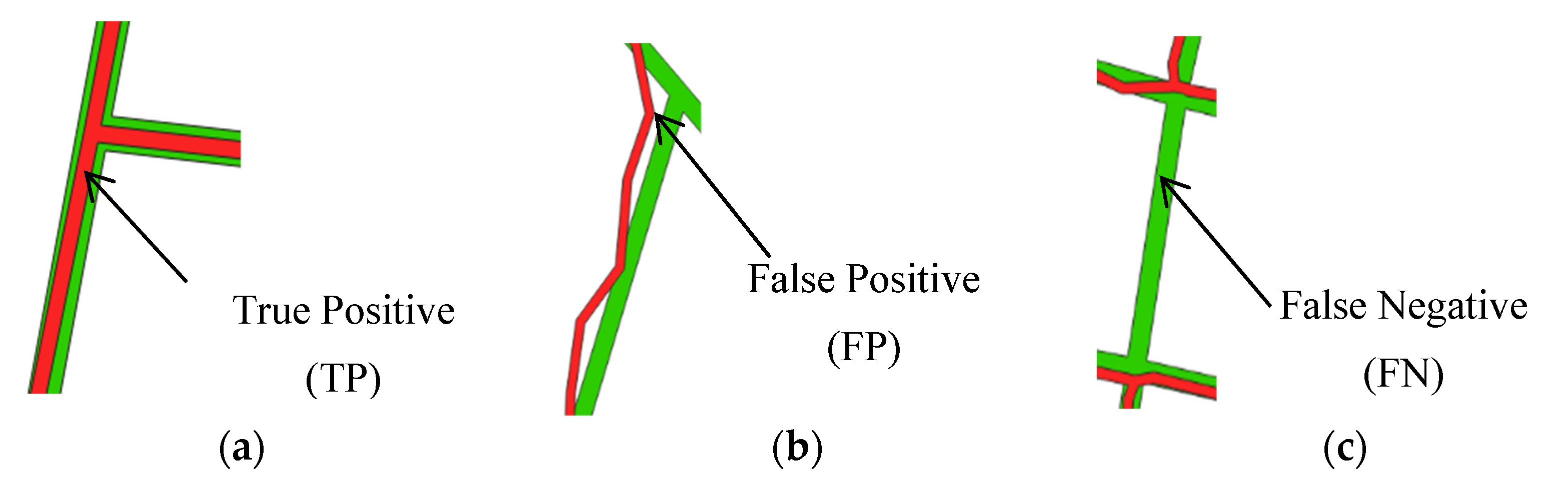
| Extracted | Boundary lines (1) | True Positive (TP) /Extracted boundaries that coincide with the reference boundaries, Figure 5a/ | False Positive (FP) /Extracted boundaries that do not coincide with the reference boundaries, Figure 5b/ |
| NonBoundary lines (0) | False Negative (FN) /Reference boundaries that are not extracted, Figure 5c/ | True Negative (TN) /nonBoundaries identified as nonBoundaries/ | |
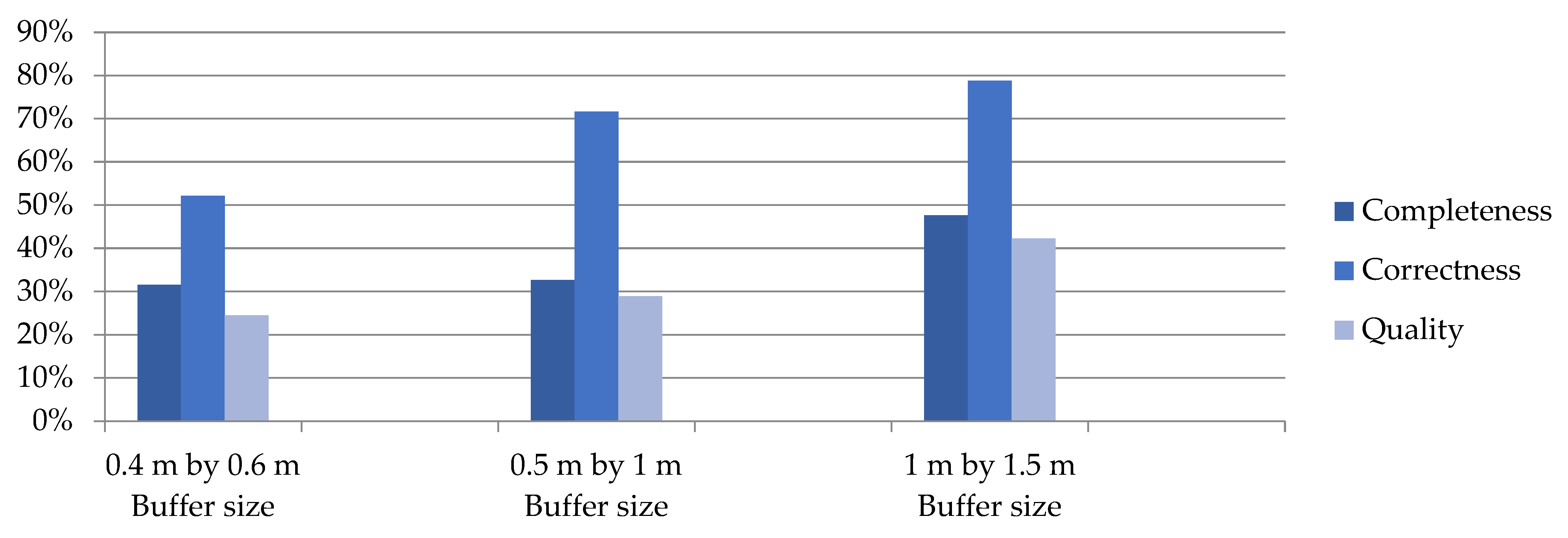
| 0.4 m by 0.6 m Buffer Size | 0.5 m by 1 m Buffer Size | 1 m by 1.5 m Buffer Size | ||||
|---|---|---|---|---|---|---|
| Boundary (1) | Non-Boundary (0) | Boundary (1) | Non-Boundary (0) | Boundary (1) | Non-Boundary (0) | |
| Boundary (1) | 25,788 | 23,631 | 28,245 | 11,151 | 15,322 | 4124 |
| Non-Boundary (0) | 55,955 | 1,625,056 | 58,328 | 1,009,960 | 16,810 | 241,980 |
| Completeness | 32% | 33% | 48% | |||
| Correctness | 52% | 72% | 79% | |||
| Quality | 24% | 29% | 42% | |||
Disclaimer/Publisher’s Note: The statements, opinions and data contained in all publications are solely those of the individual author(s) and contributor(s) and not of MDPI and/or the editor(s). MDPI and/or the editor(s) disclaim responsibility for any injury to people or property resulting from any ideas, methods, instructions or products referred to in the content. |
© 2023 by the authors. Licensee MDPI, Basel, Switzerland. This article is an open access article distributed under the terms and conditions of the Creative Commons Attribution (CC BY) license (https://creativecommons.org/licenses/by/4.0/).
Share and Cite
Metaferia, M.T.; Bennett, R.M.; Alemie, B.K.; Koeva, M. Furthering Automatic Feature Extraction for Fit-for-Purpose Cadastral Updating: Cases from Peri-Urban Addis Ababa, Ethiopia. Remote Sens. 2023, 15, 4155. https://doi.org/10.3390/rs15174155
Metaferia MT, Bennett RM, Alemie BK, Koeva M. Furthering Automatic Feature Extraction for Fit-for-Purpose Cadastral Updating: Cases from Peri-Urban Addis Ababa, Ethiopia. Remote Sensing. 2023; 15(17):4155. https://doi.org/10.3390/rs15174155
Chicago/Turabian StyleMetaferia, Mekonnen Tesfaye, Rohan Mark Bennett, Berhanu Kefale Alemie, and Mila Koeva. 2023. "Furthering Automatic Feature Extraction for Fit-for-Purpose Cadastral Updating: Cases from Peri-Urban Addis Ababa, Ethiopia" Remote Sensing 15, no. 17: 4155. https://doi.org/10.3390/rs15174155
APA StyleMetaferia, M. T., Bennett, R. M., Alemie, B. K., & Koeva, M. (2023). Furthering Automatic Feature Extraction for Fit-for-Purpose Cadastral Updating: Cases from Peri-Urban Addis Ababa, Ethiopia. Remote Sensing, 15(17), 4155. https://doi.org/10.3390/rs15174155