Abstract
Groundwater is a precious natural resource that is vital to various aspects of life. Punjab is experiencing groundwater stress due to urbanization and population growth, leading to overuse and reduced aquifer recharge. Sustainable groundwater supplies can only be created through better management and artificial recharge techniques. This study uses multi-influencing factor, literature-based, and combined techniques to identify and characterize groundwater-managed aquifer recharge potential sites (GWMARPSs) in Punjab. There are limitations to the previous work in this field, and these factors have not been used to estimate GWRPSs in the study area. The study uses GIS and RS techniques to overlay twelve geo-informative layers, with rainfall being the most significant factor. High-quality data and observations from the field are incorporated into the model. The study classifies the GWMARPSs into five categories, with Punjab having 0.34%, 13.29%, 60.68%, 25.26%, and 0.43% of the least, poorly, moderately, well-, and highly suitable sites. Punjab’s southern regions are least suitable for recharge, while some areas in eastern and northern Punjab are well-suited for recharge. Alluvial plains, valleys, low-lying areas, and areas with volcanic landforms are classified as least to poorly suitable zones. Model predictions are validated using piezometric level data and ROC and exhibit good performance (AUC, 0.74). This study could serve as a baseline for future groundwater research.
1. Introduction
Groundwater has attracted much attention due to its fundamental and essential role in everyday life. Groundwater reserves are estimated at 615 trillion cubic meters [1]. Out of 0.6% available groundwater, only 0.3% can be extracted [2]. Groundwater is the cleanest and safest fresh water because it percolates and removes impurities [3].
Pakistan is the third largest user of groundwater, consuming 9% of global extraction and accounting for 4.6% of the total area irrigated with groundwater. Surface water supplies are sufficient to irrigate 27% of the area, whereas the remaining 73% is directly or indirectly irrigated using groundwater [4]. In the 1960s, 16,700 drainage wells were built for salinity control and reclamation projects, and groundwater was exploited [5]. Pakistan faces several challenges regarding water resource depletion due to population expansion and climate change. According to the 2017 census report, Punjab is one of the most populous provinces in Pakistan, with 107 million inhabitants. Unintended urbanization and 2.1% annual population growth [6,7] have contributed to excess groundwater usage, over-abstraction, and less aquifer recharge [8]. Likewise, uncontrolled freshwater use presents risks to groundwater resources, making them vulnerable to routine exploitation [9].
Predicting groundwater recharge potential is challenging. With the egression of basin-scale groundwater models, the seasonal and geographic variability of recharge has become a very important hydrological consideration. Rainfall is a key factor, significantly contributing to groundwater recharge. Rainwater controls the water balance and restores the capacity of groundwater reservoirs [10]. Since Punjab is largely flat, there is a wide range of rainfall patterns. Punjab is mainly distributed in a semi-arid region with an annual rainfall between 250 mm and 750 mm, with arid areas with an annual rainfall between 0 mm and 250 mm [11]. Therefore, rainfall patterns are unevenly distributed in spatial and temporal domains. Due to locational variation and topography, Punjab receives most of its water during the monsoon season and a small amount during the winter, while the rest of the year is arid. The southern part of Punjab has little rainfall, while the northern region has heavy rainfall. Ultimately, heavy rains have little effect on groundwater levels in the short term, but prolonged periods of rainfall or drought undoubtedly have a large impact on groundwater levels. Variations in precipitation across seasons and years are responsible for fluctuations in groundwater levels. Water tables rise in late winter and early spring as snowpack melts and precipitation increases. However, there is a lag between precipitation infiltrating the saturated zone and rising groundwater levels. This particular trend has implications for groundwater resilience in Punjab [12]. Rainfall, geology, soil, land use, land cover, lineaments, topographic wetness index, slope, hydraulic conductivity, depth to the water table, distance to a river, drainage density, and aspect affect groundwater accessibility, availability, occurrence, and flow at any location [13,14,15,16,17].
Groundwater plays an important role in the overall water supply of Punjab, especially in rural areas. The state of Punjab encounters groundwater issues related to resource depletion, water scarcity, and contamination. Water scarcity is a major problem in Punjab [8,18]. In Punjab, hundreds of millions of people use groundwater for domestic, industrial, commercial, and agricultural purposes. Groundwater can be collected by drilling wells using diesel and electric pumps as well as by hand digging wells [4,19,20]. Without imposing any restrictions on quantity or quality, more than 60% of groundwater is pumped from groundwater reservoirs. The breadbasket of Pakistan is 12.42 million hectares of arable land, accounting for more than 66% of the habitat in Punjab [21]. Punjab’s groundwater pumpage rate is very high, and more than 0.95 million tube wells have been installed in Punjab [22]. Overall, Punjab residents are highly dependent on groundwater. In the plains of Punjab, one of the most important and critical areas for crop production, groundwater levels have been reportedly depleted at a rate of 0.5 ft to 3 ft annually [23] and have decreased over time due to over-abstraction [24]. Saltwater intrusion, soil subsidence, and piezometric water table decline have also contributed to its deterioration. Nearly 50% of the groundwater in the Indus Valley has been used for agricultural purposes [25].
To investigate the presence and accessibility of groundwater, various methods have been used. Researchers have also investigated the possibility of modest replenishment of groundwater. Unfortunately, traditional hydrological, geological, and geophysical approaches cannot maintain the aquifer due to expensive and labor-intensive drilling costs [26,27]. Due to complex hydrogeological characteristics and limited aquifer information, the flow patterns in the study area are not well defined, making it difficult to understand the aquifer system in Punjab [28,29,30]. Groundwater-managed aquifer recharge potential sites were not identified in previous studies through the application of multi-influencing factor (MIF), literature-based, and combined techniques using GIS and RS; this represents a limitation of prior work done in the area of managed aquifer recharge potential sites. The current study fills this gap. GIS and RS methods are easy to use and allow accurate assessment of the significant areas [31,32]. Geographic Information Systems (GISs) and Remote Sensing (RS) are practical tools for analyzing satellite data and determining groundwater-managed aquifer recharge potential sites, even in inaccessible areas [31,33,34,35,36,37,38,39]. To bridge the gap between the decision-making process and water scarcity, Refs. [40,41,42] outlined how to apply multi-criteria decision analysis (MCDA), multi-influencing factors (MIFs), and the analytic hierarchy process (AHP) in groundwater investigations. A viable method for complex decision analysis is the analytic hierarchy process. Concordance and random ratios were assessed using a multiple-pair comparison matrix [19,43,44,45,46,47,48]. Cross-correlation analysis was performed on pre- and post-monthly monsoon time-series data to assess groundwater level changes.
Considering the above facts, this study focuses on understanding the behavior of groundwater-managed aquifer recharge potential sites and regional mapping using GIS and RS techniques. Considering the shortcomings of earlier studies in Punjab, this study includes the following novel elements: (1) Identification of the main factors that have a significant impact on groundwater recharge; (2) normalization of the assigned weights using MCDA and modification of the rating values for the sub-classes using MIF, literature-based, and combined techniques; (3) assessment of the groundwater-managed aquifer recharge potential site map; (4) assessment of the accuracy of the GWRPS map using ROC and groundwater level variation maps. The methods used in this study could also be applied in other parts of the country to help better plan, manage, and maintain aquifers.
2. Materials and Methods
2.1. Description of the Study Area
Punjab, Pakistan, is the second largest province in the country, with a land area of approximately 205,432 square kilometers, and is densely populated. It is located on the northwestern margin of the Indian plate in South Asia, between 27°44′N to 34°15′N and 69°20′E to 75°20′E (Figure 1). It is divided into 36 districts, 146 tehsils, and 7602 union councils. In Punjab, there are 28 meteorological stations. The average annual rainfall ranges from 100 to 1800 mm. However, the northwestern and southeastern highlands in the study area have an average annual precipitation of more than 1600 mm [49]. There are four seasons, i.e., summer, winter, spring, and autumn. Temperatures in the study region generally range from −2 °C to 45 °C, reaching up to 50 °C in summer and dropping to −10 °C in winter [50]. The province has the largest irrigation system in Pakistan, consisting of nearly 3000 irrigation channels. The agricultural sector of Punjab produces large quantities of wheat, rice, cotton, and sugar cane. Oilseeds, millet, maize, vegetables, pulses, and fruits, including mangoes and oranges, are grown. Punjab has many industrial production facilities, producing sporting goods, textiles, cement, heavy equipment, sugar, agricultural machinery, and other products.
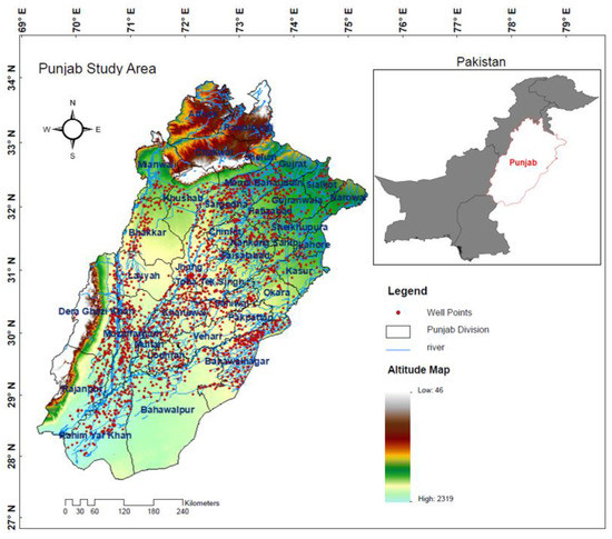
Figure 1.
The geographic location of the study area, along with a spatial map of a piezometric well.
2.2. Hydrogeology, Geological Formation, and Aquifer Characterization of Study Area
The development and regularity of groundwater formation in natural environments are characterized by hydrogeological conditions, which also provide detailed information on soil permeability, hydraulic conductivity, and porosity. They relate to how water enters the earth, travels underground (through aquifers), and interacts with the soil and rocks in the area. Geological features that promote landform development and influence hydrogeological processes are faults, fractures, joints, and folds [15]. Much of the Punjab region suffers from salinization and waterlogging due to extensive irrigation systems. The deeper water table can be affected by various changes in the topography of Punjab, which has historically been known as a recharge zone. Complex drainage systems recharge the plain aquifers due to steep gradient changes. Areas with higher rainfall significantly influence the hydrogeology of the region compared to areas with less rain. Groundwater recharge systems can be supported by irrigation and infiltration canals for site-specific seepage and recharge.
Geological studies have shown that the Punjab region is covered with unconsolidated alluvium to a depth of about 1000 feet, covered by alluvium (sand, silt, and clay), which hides the bedrock. Sirowal (silt and clay with a little sand; infiltrated by red clay and gravel of channel origin), Kandi (boulders, pebbles, gravel, and sand with a little clay), Intermontane (boulders, pebbles, gravel, and coarse sand with clay). and Upper Siwalik (Pinjore boulder bed, boulder conglomerate, Pinjore sandstone, and shale) contain groundwater reserves. The alluvium is saturated with groundwater within a few feet of the surface, replenishing through infiltration, irrigation, and rainfall [51].
However, older eolian deposits, older terrace deposits, Piedmont and related deposits, Cretaceous and Jurassic sedimentary rocks, deposits of extinct streams, Tertiary deposits, Steam deposits, Quaternary Deposits, Early Mesozoic and late Paleozoic rocks, Cambrian deposits, and Alluvium deposits are all part of the characterization of the aquifer in Punjab [17].
2.3. Data Collection and Thematic Layer Preparation
Groundwater varies widely from site to site, depending on topographical characteristics, hydrogeological variables, and climate. The thematic layers used in this research were created using a variety of datasets, including meteorological data, remote sensing data, and conventional data from existing maps. Based on data availability, expert opinion, and various studies conducted to determine managed aquifer recharge potential sites, factors such as rainfall (Rf), geology (Ge), soil (So), land use land cover (LULC), lineaments (Le), topographic wetness index (TWI), slope (Sl), hydraulic conductivity (K), depth to water table (DWT), distance to a river (DTR), drainage density (Dd), and aspect (As) were selected. Figure 2 illustrates the comprehensive methodology and data analysis flow chart, while Table 1 presents the data set collected from multiple sources. Daily rainfall data from 28 weather stations were sorted in Excel to produce the rainfall map, displayed and imported into the GIS. We created isohyetal and contour maps by interpolating data using kriging techniques. The Geological Survey of Pakistan and the Soil Survey provided access to geological and soil maps. A land use land cover map was created using imagery from the Application for Extracting and Exploring Analysis Ready Samples.
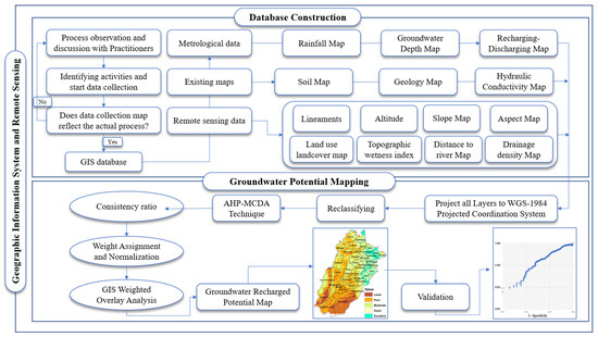
Figure 2.
Flow chart of methodology.

Table 1.
Multiple sources comprising the data set.
Maximum likelihood in the supervised classification technique was used to generate the LULC map. Using an inbuilt line density tool, the Landsat band, 4 images at 30 m resolution were used in PCI Geometrica 2018 software to extract the lineaments map. A digital elevation model at 30 m resolution was used for extracting thematic layers, including slope, elevation, topographic wetness index, aspect, distance to a river, and drainage density. Slope, aspect, and altitude were calculated using the Slope, Aspect, and Value of the Point tools in Arc-GIS. The Euclidean distance tool in ArcGIS 10.8 Spatial Analyst Tools created the distance-to-river categories. The hydraulic conductivity map was taken from a previous study [31]. The depth-to-water-table map was created using piezometer data. As a result, maps of each parameter were created to help map groundwater-managed aquifer recharge potential sites.
2.4. Weight Allocation and Normalization
The Analytic Hierarchy Process is a multi-criteria decision-making method that was first proposed by Professor Thomas L. Saaty in 1970. The technique uses a balanced scale to evaluate the importance of each layer. To solve complex problems, Saaty developed a hierarchical structure technique; judging the scale greatly influences the priority of the criteria. This study compares and discusses MIF, literature-based, and combined techniques for uncertainty reduction and MARPS mapping: (i) The MIF technique involves the interrelationship among the factors and assigns weights according to the strength of the interrelationships. The stronger the relationship, the higher the weight of the parameter of the MARPS [19,52,53]. (ii) The literature-based technique involves the assembled average weight; this method incorporates the averaging process and assigns an average weight value based on 12 comparable studies. Table 2 shows the proportional importance of the selected parameters in the various studies. The weight of a factor can vary considerably between studies. Because of this uncertainty, the calculated component averages are based on studies conducted in several countries over the past decade [54]. (iii) The combined method averages the weight values from the MIF method and the literature-based technique [55]. This averaging reduces the uncertainty of choosing the weightage values for the factors. Saaty (2008) suggested applying relative scale values to generate paired measures of AHP. The basic steps in the goal-setting process are to establish a pairwise comparison matrix based on the scaling weight (Equation (1)) [56], calculate the geometric mean (Equation (2)), normalize the weight (Table 3 and Equation (3)), and check the consistency ratio (Table 4 and Equation (4)) and accuracy before final weightage (Figure 3 and Equation (5)) to ensure coherent judgments.

Table 2.
Literature used in previous studies as per Satty scale.

Table 3.
Proportional weights and ranking based on expert opinion and the literature.

Table 4.
Principal eigenvectors and consistency ratio for each class.
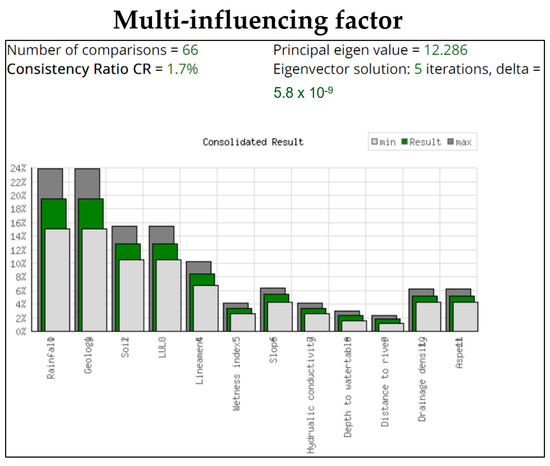
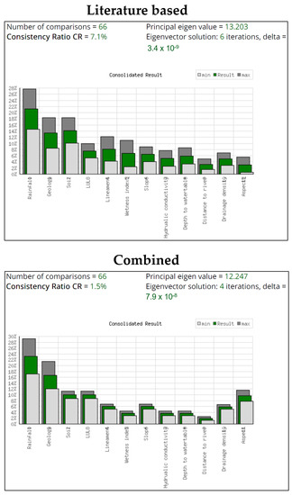
Figure 3.
Accuracy assessment before weight normalization.
The proportional weights for each variable were determined based on expert opinion and the literature. To ensure functionality for subsequent overlay analyses, the input layers created for each factor were eventually transformed, reclassified, and resampled to a new raster layer with the same cell size (Table 5). The raster calculator in ArcGIS was used to superimpose the layers using Equation (7). The values for the groundwater-managed aquifer recharge potential sites that were obtained span a continuous range from 1 to 5. The data must be transformed into discrete values to be sorted into classes (Table 6).
where n = number of criteria, w = weight, r = relative weight, wi = eigenvalue of criterion i, λ max = average eigenvalue of the pairwise comparison matrix, CI = consistency index, RI = random consistency index; if the consistency ratio of the matrix is greater than 0.1, the matrix should be re-evaluated.

Table 5.
Reclassification and ranking of all parametric layers.

Table 6.
Types of MARPSs.
MIF, literature-based, and combined techniques, followed by AHP, are used to check the accuracy of experiments, that is, how close the final results are to correct or acceptable values. The closer the results are, the more accurate the experiment. According to the Satty scale, the consistency ratio must be equal to or less than 10%. If it is lower than the design value, it is used for further calculations, and the statement is considered subjective, and vice versa.
3. Results and Discussion
3.1. Parameters That Control Managed Aquifer Recharge Potential Sites
Rainfall is the primary groundwater-forming factor and has a great influence. Rainfall regulates the groundwater water-balance reservoir and restores groundwater capacity [10,12]. Since most of Punjab is flat, the rainfall pattern can vary considerably. The rainfall has a direct relation with altitude. Due to the high altitude and abundant rainfall in the area, the groundwater recharge area is immediately affected by groundwater infiltration and percolation, and vice versa. The Northeast and Northwest receive the most rainfall, ranging from 1000 to 1800 mm/year, while the Southwest and Southeast receive less rainfall, ranging from 100 to 200 mm/year. Central regions of Punjab usually receive a normal to moderate rainfall of 200 to 300 mm/year and 300 to 800 mm/year, correspondingly [61,62]. Geology allows water to infiltrate or seep into the earth, and underground reservoirs must store water and maintain their balance capacity. At the same time, it regulates the flow and mineral composition of groundwater. Due to Punjab’s large area, many sedimentary, alluvial, metamorphic, and ingenious rocks can be found there [16]. Soil is very important in restoring groundwater balance. The soil texture affects properties such as permeability, hydraulic conductivity, porosity, condensation, and hygroscopicity. Soil is essential for water quality and purification. The soil map of the study area is derived from the Punjab Land Survey. Figure 4 depicts the many soil groups in the study area. Land use/land cover is one of the most critical factors affecting the study of groundwater recharge capacity. Evapotranspiration, surface runoff, and groundwater recharge are all directly affected. Water bodies such as lakes, ponds, rivers, and springs are good and effective sources of groundwater replenishment, as are agricultural lands, including croplands, pastures, natural shrub and herbaceous areas, and orchards. Groundwater recharge is not significantly affected by barren land or large, hard rocks. The Landsat Dataset 8.1 and Arc GIS 10.8 were used to create the map, which was then classified into twelve categories using maximum likelihood. Lineaments are linear features that represent structural discontinuity and can be detected from aerial or satellite imagery. They are directly related to recharging and allow water to seep into the ground. Lineaments were extracted from satellite imagery and mapped using PCI Geomatica [63,64,65]. Lineament density ranges from 0.01 km/km2 to 0.79 km/km2.
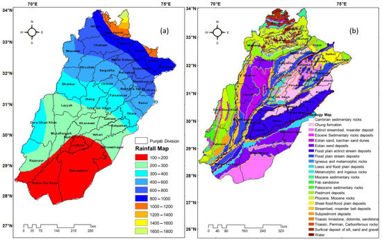
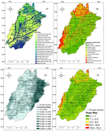
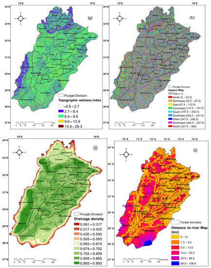
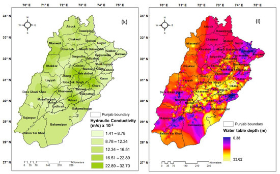
Figure 4.
Map showing original weight for (a) rainfall, (b) geology, (c) soil, (d) land use/land cover, (e) lineaments, (f) slope, (g) topographic wetness index, (h) aspect, (i) drainage density, (j) distance to river, (k) hydraulic conductivity, and (l) water table depth.
The difference in elevation between high and low altitudes is called slope. The slope is considered a key regulator of the infiltration that recharges subsurface basins. Slope directly affects how much water restores the ground. Areas with higher slopes are poorly recharged, meaning they recharge the watershed less efficiently and have higher runoff values than flat areas, which provide more infiltration and recharge to the land. The slope map was created using the Slope tool in ArcGIS 10.8 [53,66,67]. The resulting map classified slopes as flat, gentle, medium, high, and steep. Punjab terrain is flat and mild, and such terrain types receive a high ranking due to their ability to hold, store, and transport water to the surface. Low ranking is given to steep slope areas. Aspect can be thought of as the slope direction. The values in the output raster correspond to the compass directions for aspect. The factor aspect has not been exploited in many studies. Still, since it is a measure of received solar radiation and is related to evapotranspiration, it is considered a good indicator of groundwater recharge [68,69,70]. The topographic wetness index (TWI) is a steady-state wetness index used to quantify topographic control in hydrological processes. It is determined by slope and upstream contributing area per unit width, orthogonal to the flow direction [71]. Drainage removes excess water from the surface or underground by natural or artificial means. Ref. [72] explains that drainage systems provide information on subsurface rock formations, soil permeability, soil hydraulic conductivity, and soil infiltration potential. Punjab has various soil types that include dendritic, parallel, rectangular, and rough drainage networks. Watershed values in the Southwest and Northwest are very high, at 0.0992 km/km2. These sites have increased runoff, high slopes, and low groundwater potential. However, most study areas are in the normal to moderate range, between 0.317 and 0.42 km2/km2 and between 0.43 and 0.51 km2/km2, respectively. The drainage density map is reclassified into five types, including high drainage density in silty and sandy soils and low in clayey and calcareous clayey soils. The distance to the river is 0–1.3 km, 1.3–5 km, 5.0–13.01 km, 13.01–35 km, and 35–108.6 km. The depth-to-water-table map ranges from 0.38 to 33.62 feet. The hydraulic conductivity map was taken from previous studies and ranges from 1.41 to 32.70 (m/s) × 10−3 (see Figure 4 and Figure 5).
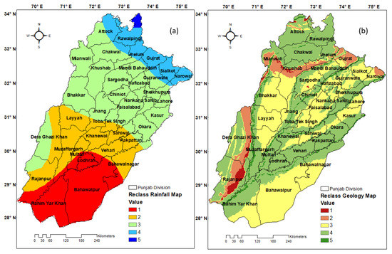
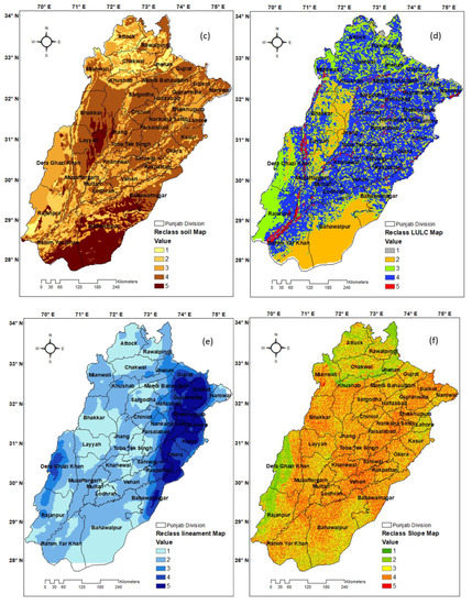
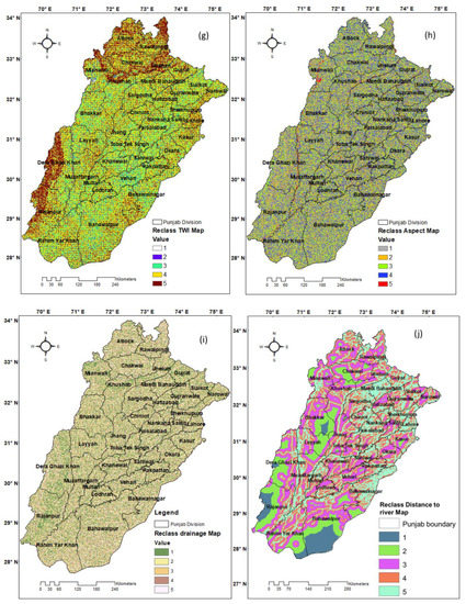
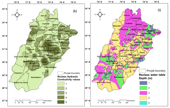
Figure 5.
Maps showing the relative weights for (a) rainfall, (b) geology, (c) soil, (d) land use/land cover, (e) lineaments, (f) slope, (g) topographic wetness index, (h) aspect, (i) drainage density, (j) distance to river, (k) hydraulic conductivity, and (l) water table depth.
3.2. Delineation of Favorable Managed Aquifer Recharge Potential Sites
Groundwater recharge varies widely across locations, depending on groundwater storage, topographical factors, hydrogeological variables, topography, and climatic conditions. The managed aquifer recharge potential sites in Punjab were mapped using GIS and RS techniques. This was achieved by overlaying 12 geo-informative layers following the basic principles of Equation (8). Three different approaches were used to determine the relative weight of each component and thus reduce the uncertainty of the final weights. In all categories of GWMARPSs, MIF and literature-based weighting procedures differ slightly. The results are shown and discussed. Please see Table 6 and Figure 6 and Figure 7 for more detail. Variables such as rainfall, lineaments, soil, geology, and LULC obtained higher values than other factors, such as slope, aspect, topographic wetness index, and drainage density. Most of the Punjab area is in a moderate to suitable zone. The GWMARPS map is divided into five categories. Punjab had 0.34%, 13.29%, 60.68%, 25.26%, and 0.43% of the least, poorly, moderately, well-, and highly suitable zones for recharge potential, respectively.
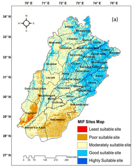
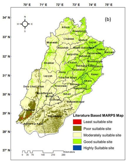
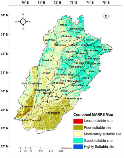
Figure 6.
Map of managed aquifer recharge potential sites: (a) MIF, (b) literature-based, and (c) combined.
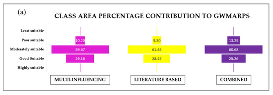
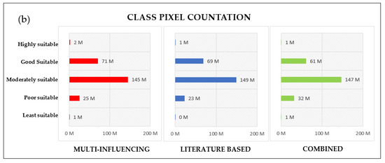
Figure 7.
Map showing (a) class area percentage and (b) class pixel contribution to each class.
Groundwater recharge, a strategy for managing groundwater resources, uses integrated GIS technology to identify MARPSs throughout the province of Punjab. This method is more reliable and efficient than traditional field surveys because it costs less and takes less time. Three methods were used to determine the weight values for the various criteria. MARPSs have low uncertainties due to interactions between the individual components. Neither these nor other groundwater-related parameters are included in national databases, although drilling is often used for verification. A comparison of the Punjab geological map and the MARPS map reveals a broad and consistent correlation between areas of high MARPSs. Pleistocene gravel as well as glacial and alluvial deposits are highly associated with the northern high MARPS area. According to other studies, MARPS areas are geographically distributed, with densely populated areas having the lowest MARPS efficiency. MARPSs were the most abundant in flat terrain with alluvium and quaternary material, riverbanks, and agricultural areas. Dera Ghazi Khan, Rajanpur, and Rojhan districts are some of the least-promising districts in southern Punjab.
Only a small part of the eastern and northern areas of Punjab (including Rawalpindi, Gujarat, Sialkot, Gujranwala, South Karna Sahib, and most of the Ocala region) is classified as a high-replenishment-capacity area. The eastern, western, and southern parts of Punjab are classified as good, average, and poor charging zones, respectively.
3.3. Validation
Physical models show promise for quantitative assessments of aquifer systems’ natural recharge rates, but they also require extensive hydrogeological data and computer simulations. Recharge potential sites can be mapped in developing countries using statistical and machine learning techniques. Despite recent improvements in the ability of ensemble techniques to improve model predictions and minimize uncertainty, scientific research on nature’s potential is still in its early stages. The research results were cross-validated by the reservoir operation curve using the IBM SPSS Package and, alternatively, the ROC GIS tool [60]. The area under the curve (AUC) shows each method’s 0.66, 0.69, and 0.74 success rates (Figure 8).

Figure 8.
ROC curve for each method.
In addition, final maps were also validated by examining seasonal variations [39,61] in the study area using piezometer field data (Figure 9). The change map is shown where the post-monsoon groundwater table is deeper than the pre-monsoon depth due to rainfall recharge.
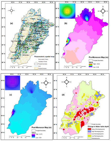
Figure 9.
(a) Geospatial map of piezometers. (b) Pre-monsoon map. (c) Post-monsoon map. (d) Change in depth.
4. Conclusions
The results of this study were evaluated and analyzed using geographic information systems and remote sensing through an analytical hierarchical decision-making process. These findings are based on variables that have the greatest impact on groundwater recharge potential and the presence of recharge zones. Rainfall is the most influential factor, with a weightage of 22.94%. The consistency ratios were 0.017, 0.077, and 0.015 for MIF, literature-based, and combined techniques. Punjab regions such as Dera Ghazi Khan, Rajanpur, and Rojhan are among the least suitable areas. Regions of eastern and northern Punjab are well suited for recharge potential, including Rawalpindi, Gujarat, Sialkot, Gujranwala, south Nankana Sahib, and Ocala. The eastern, western, and southern parts of Punjab are in moderate, and low recharge rate zones, respectively. Alluvial plains, filled valleys, and low-lying and high-lying areas were found to have sedimentary patches within very high to high recharge-favorable zones. Areas surrounding volcanic landforms, with high slopes, and with high drainage densities with bare and sparse natural vegetation were classified as least to poorly suitable zones. Punjab had 0.34%, 13.29%, 60.68%, 25.26%, and 0.43% of areas that were least, poorly, moderately, well-, and highly suitable as acceptable recharge zones, respectively. The validation result for each class was 0.66, 0.69, and 0.74. The piezometric data analysis showed that out of 2350 piezometers, 1790 piezometers showed a decline in water level, and 560 piezometers showed a rise in water level. The current method is favorable, practical, economical, and time-effective for identifying suitable groundwater recharge areas. The resulting map can be used as a resource for prospects, groundwater managers, long-term management, and other research and resource information. Based on the results of this study, a hydro-geophysical review of potential drilling sites is recommended for field validation. These places can be used as artificial recharging sites, and flooding water may serve to recharge these areas. Using the same data as in this study, we propose to apply a drastic model, a bivariate function, a belief function, and numerical modeling techniques in Punjab.
Author Contributions
Conceptualization, M.A. and T.L.; methodology and data curation, M.A.; software and visualization, M.A., A.Q.B. and A.A.N.; formal analysis and writing—original draft preparation, M.A. and S.A.; review and editing of previous drafts, M.A. and X.P.; supervision and funding acquisition, T.L. All authors have read and agreed to the published version of the manuscript.
Funding
This work was supported by the K.C. Wong Education Foundation (GJTD-2020-14), the National Natural Science Foundation of China (Grant No. 42071245), Third Xinjiang Scientific Expedition Program (Grant No. 2021XJKK1044), Key Program of International Cooperation, Bureau of International Cooperation, Chinese Academy of Sciences (Grant No. 131551KYSB20210030), CAS International Partner Project (Grant No. 131965KYSB20200029), and CAS Research Center for Ecology and Environment of Central Asia (Grant No. Y934031).
Data Availability Statement
Data are available upon request.
Acknowledgments
A special acknowledgement should be expressed to China-Pakistan Joint Research Center on Earth Sciences that supported the implementation of this study. Muhammad Afzal would like to express his sincere gratitude to the Chinese Academy of Sciences (CAS) and the CSC Scholarship for Young Talents (Doctor Program) for the financial support of this study. The authors thank the Agencies of Hydrometeorology and Climatology under the Government of the Republic of Pakistan for providing the data for this research.
Conflicts of Interest
The authors declare no conflict of interest.
References
- Raghunath, H.M. Ground Water: Hydrogeology, Ground Water Survey and Pumping Tests, Rural Water Supply and Irrigation Systems; New Age International: New York, NY, USA, 1987. [Google Scholar]
- Foster, S. Groundwater: Assessing vulnerability and promoting protection of a threatened resource. In Water—The Key to Socio-economic Development and Quality of Life, Proceedings of the 8th Stockholm Water Symposium, Stockholm, Sweden, 10–13 August 1998; IRC International Water and Sanitation Centre: Stockholm, Sweden, 1998; pp. 79–90. [Google Scholar]
- Xiao, F.; Simcik, M.F.; Halbach, T.R.; Gulliver, J.S. Perfluorooctane sulfonate (PFOS) and perfluorooctanoate (PFOA) in soils and groundwater of a US metropolitan area: Migration and implications for human exposure. Water Res. 2015, 72, 64–74. [Google Scholar] [CrossRef]
- Ahmed, U.; Sarwar, A.; Khalil, F.A.; Gulzar, S.; Qayum, N.; Qureshi, R. Mapping Groundwater Potential Zones Using Satellite Remote Sensing and GIS. In GIScience for the Sustainable Management of Water Resources; Apple Academic Press: Palm Bay, FC, USA, 2022; pp. 109–126. [Google Scholar]
- World Bank. Managing Groundwater Resources in Pakistan’s Indus Basin. Available online: https://www.worldbank.org/en/news/feature/2021/03/25/managing-groundwater-resources-in-pakistan-indus-basin (accessed on 25 July 2023).
- PBS. Home|Pakistan Bureau of Statistics. 2017. Available online: https://www.pbs.gov.pk/ (accessed on 13 April 2023).
- Wazir, M.A.; Goujon, A. Assessing the 2017 Census of Pakistan using Demographic Analysis: A Sub-National Perspective; Vienna Institute of Demography Working Papers; Vienna Institute of Demography: Vienna, Austria, 2019. [Google Scholar]
- Watto, M.A. The Economics of Groundwater Irrigation in the Indus Basin, Pakistan: Tube-Well Adoption, Technical and Irrigation Water Efficiency and Optimal Allocation. Ph.D. Thesis, University of Western Australia, Crawley, Australia, 2015. [Google Scholar]
- Nadeem, A.A.; Zha, Y.; Mehmood, K.; Awais, M.; Afzal, M.M.; Hussain, H. Quantification of temporal variations in groundwater level using satellite imagery technique: A case study of Rachna Doab, Pakistan. Int. J. Environ. Sci. Technol. 2023, 20, 2565–2580. [Google Scholar] [CrossRef]
- Salma, S.; Rehman, S.; Shah, M.A. Rainfall trends in different climate zones of Pakistan. Pak. J. Meteorol. 2012, 9. [Google Scholar]
- Nawaz, Z.; Li, X.; Chen, Y.; Guo, Y.; Wang, X.; Nawaz, N. Temporal and spatial characteristics of precipitation and tem-perature in Punjab, Pakistan. Water 2019, 11, 1916. [Google Scholar] [CrossRef]
- Usman, M.; Liedl, R.; Kavousi, A. Estimation of distributed seasonal net recharge by modern satellite data in irrigated agricultural regions of Pakistan. Environ. Earth Sci. 2015, 74, 1463–1486. [Google Scholar] [CrossRef]
- Gintamo, T.T. Ground water potential evaluation based on integrated GIS and remote sensing techniques, in bilate River Catchment: South Rift Valley of Ethiopia. Am. Sci. Res. J. Eng. Technol. Sci. 2015, 10, 85–120. [Google Scholar]
- Shaban, A.; Khawlie, M.; Abdallah, C.; Faour, G. Geologic controls of submarine groundwater discharge: Application of remote sensing to north Lebanon. Environ. Geol. 2005, 47, 512–522. [Google Scholar] [CrossRef]
- The Hydrogeology of Adama-Wonji Basin and Assessment of Groundwater Level Changes in Wonji Wetland, Main Ethiopian Rift: Results from 2D Tomography and Electrical Sounding Methods|SpringerLink. Available online: https://link.springer.com/article/10.1007/s12665-010-0619-y (accessed on 25 July 2023).
- Geology Map of Punjab Pakistan—Google Search. Available online: https://www.google.com.hk/search?q=geology+map+of+punjab+pakistan&newwindow=1&client=firefox-b-d&sxsrf=AB5stBg9emeY1GTZOGQBOddz_DtC1XQLtw%3A1690281166064&ei=zqS_ZPrJA_Hk0PEPwsW0yAY&oq=geologymap++on+punjab+pakistan&gs_lp=Egxnd3Mtd2l6LXNlcnAiHmdlb2xvZ3ltYXAgIG9uIHB1bmphYiBwYWtpc3RhbioCCAAyBxAjGLACGCdI6hxQ4wtYnBBwAHgDkAEBmAGIBqABgRKqAQkzLTEuMC4yLjG4AQPIAQD4AQHCAgQQABhH4gMEGAAgQYgGAZAGBg&sclient=gws-wiz-serp (accessed on 25 July 2023).
- Malkani, M.S.; Haroon, Y. Lithostratigraphy, Structure, Geological History, Economic Geology and Paleontology of Mari Bugti Hills and Surrounding Areas of Balochistan, South Punjab and North Sindh (Pakistan). Open J. Geol. 2022, 12, 13–56. [Google Scholar] [CrossRef]
- Safdar, F.; Khokhar, M.F.; Arshad, M.; Adil, I.H. Climate Change Indicators and Spatiotemporal Shift in Monsoon Patterns in Pakistan. Adv. Meteorol. 2019, 2019, e8281201. [Google Scholar] [CrossRef]
- Masoud, A.M.; Pham, Q.B.; Alezabawy, A.K.; El-Magd, S.A.A. Efficiency of geospatial technology and multi-criteria decision analysis for groundwater potential mapping in a Semi-Arid region. Water 2022, 14, 882. [Google Scholar] [CrossRef]
- Qureshi, A.S.; Shah, T.; Akhtar, M. The Groundwater Economy of Pakistan; International Water Management Institute: Lahore, Pakistan, 2003; Volume 64. [Google Scholar]
- Qureshi, A.S. Improving food security and livelihood resilience through groundwater management in Pakistan. Glob. Adv. Res. J. Agric. Sci. 2015, 4, 687–710. [Google Scholar]
- Siddiqi, A.; Wescoat, J.L., Jr. Energy use in large-scale irrigated agriculture in the Punjab province of Pakistan. Water Int. 2013, 38, 571–586. [Google Scholar] [CrossRef]
- The Punjab Water Act. 2019. Available online: http://punjablaws.gov.pk/laws/2743.html (accessed on 13 April 2023).
- Qureshi, A.S.; Gill, M.A.; Sarwar, A. Sustainable groundwater management in Pakistan: Challenges and opportunities. Irrig. Drain. J. Int. Comm. Irrig. Drain. 2010, 59, 107–116. [Google Scholar] [CrossRef]
- Sarwar, A.; Eggers, H. Development of a conjunctive use model to evaluate alternative management options for surface and groundwater resources. Hydrogeol. J. 2006, 14, 1676–1687. [Google Scholar] [CrossRef]
- Rangzan, K.; Charchi, A.; Abshirini, E.; Dinger, J. Remote sensing and GIS approach for water-well site selection, southwest Iran. Environ. Eng. Geosci. 2008, 14, 315–326. [Google Scholar] [CrossRef]
- Thangarajan, M. Groundwater: Resource Evaluation, Augmentation, Contamination, Restoration, Modeling and Management; Springer Science & Business Media: Berlin/Heidelberg, Germany, 2007. [Google Scholar]
- Bennett, G.D. Analysis of Aquifer Tests in the Punjab Region of West Pakistan; US Government Printing Office: Washington, DA, USA, 1967.
- ALaghari, N.; Vanham, D.; Rauch, W. The Indus basin in the framework of current and future water resources man-agement. Hydrol. Earth Syst. Sci. 2012, 16, 1063–1083. [Google Scholar] [CrossRef]
- Schmid, W.; Punthakey, J.; Hodgson, G.; Kirby, M.; Ahmad, M.; Podger, G.M.; Stewart, J.; Basharat, M.; Khero, Z.; Bodla, H.U. Development of a Regional Groundwater Model for the Indus Basin Irrigation System of Pakistan; CSIRO: Canberra, Australia, 2017.
- Arshad, A.; Zhang, Z.; Zhang, W.; Dilawar, A. Mapping favorable groundwater potential recharge zones using a GIS-based analytical hierarchical process and probability frequency ratio model: A case study from an agro-urban region of Pakistan. Geosci. Front. 2020, 11, 1805–1819. [Google Scholar] [CrossRef]
- Chowdhury, A.; Jha, M.K.; Chowdary, V.M. Delineation of groundwater recharge zones and identification of artificial recharge sites in West Medinipur district, West Bengal, using RS, GIS and MCDM techniques. Environ. Earth Sci. 2010, 59, 1209–1222. [Google Scholar] [CrossRef]
- Alam, F.; Azmat, M.; Zarin, R.; Ahmad, S.; Raziq, A.; Young, H.-W.V.; Nguyen, K.-A.; Liou, Y.-A. Identification of potential natural aquifer recharge sites in Islamabad, Pakistan, by integrating GIS and RS techniques. Remote Sens. 2022, 14, 6051. [Google Scholar] [CrossRef]
- Andualem, T.G.; Demeke, G.G. Groundwater potential assessment using GIS and remote sensing: A case study of Guna tana landscape, upper blue Nile Basin, Ethiopia. J. Hydrol. Reg. Stud. 2019, 24, 100610. [Google Scholar] [CrossRef]
- Kabeto, J.; Adeba, D.; Regasa, M.S.; Leta, M.K. Groundwater Potential Assessment Using GIS and Remote Sensing Techniques: Case Study of West Arsi Zone, Ethiopia. Water 2022, 14, 1838. [Google Scholar] [CrossRef]
- Parks, S.; Byrnes, J.; Abdelsalam, M.G.; Dávila, D.A.L.; Atekwana, E.A.; Atya, M.A. Assessing groundwater accessibility in the Kharga Basin, Egypt: A remote sensing approach. J. Afr. Earth Sci. 2017, 136, 272–281. [Google Scholar] [CrossRef]
- Singh, S.K.; Zeddies, M.; Shankar, U.; Griffiths, G.A. Potential groundwater recharge zones within New Zealand. Geosci. Front. 2019, 10, 1065–1072. [Google Scholar] [CrossRef]
- Raza, I.; Farooq, B.; Khurram, S.; Khalid, P.; Ehsan, M.I.; Muhammad, S. Delineation of Ground Water Recharge Potential Zones in Lahore District, Punjab, Using Remote Sensing and GIS Techniques. Int. J. Econ. Environ. Geol. 2022, 13, 16–23. [Google Scholar] [CrossRef]
- Maqsoom, A.; Aslam, B.; Khalid, N.; Ullah, F.; Anysz, H.; Almaliki, A.H.; Almaliki, A.A.; Hussein, E.E. Delineating groundwater recharge potential through remote sensing and geographical information systems. Water 2022, 14, 1824. [Google Scholar] [CrossRef]
- da Costa, A.M.; de Salis, H.H.C.; Viana, J.H.M.; Pacheco, F.A.L. Groundwater recharge potential for sustainable water use in urban areas of the Jequitiba River Basin, Brazil. Sustainability 2019, 11, 2955. [Google Scholar] [CrossRef]
- Gupta, M.; Srivastava, P.K. Integrating GIS and remote sensing for identification of groundwater potential zones in the hilly terrain of Pavagarh, Gujarat, India. Water Int. 2010, 35, 233–245. [Google Scholar] [CrossRef]
- Senanayake, I.P.; Dissanayake, D.; Mayadunna, B.B.; Weerasekera, W.L. An approach to delineate groundwater recharge potential sites in Ambalantota, Sri Lanka using GIS techniques. Geosci. Front. 2016, 7, 115–124. [Google Scholar] [CrossRef]
- Abrams, W.; Ghoneim, E.; Shew, R.; LaMaskin, T.; Al-Bloushi, K.; Hussein, S.; AbuBakr, M.; Al-Mulla, E.; Al-Awar, M.; El-Baz, F. Delineation of groundwater potential (GWP) in the northern United Arab Emirates and Oman using geospatial technologies in conjunction with Simple Additive Weight (SAW), Analytical Hierarchy Process (AHP), and Probabilistic Frequency Ratio (PFR) techniques. J. Arid. Environ. 2018, 157, 77–96. [Google Scholar] [CrossRef]
- Fashae, O.A.; Tijani, M.N.; Talabi, A.O.; Adedeji, O.I. Delineation of groundwater potential zones in the crystalline basement terrain of SW-Nigeria: An integrated GIS and remote sensing approach. Appl. Water Sci. 2014, 4, 19–38. [Google Scholar] [CrossRef]
- Mukherjee, I.; Singh, U.K.; Chakma, S. Evaluation of groundwater quality for irrigation water supply using multi-criteria decision-making techniques and GIS in an agroeconomic tract of Lower Ganga basin, India. J. Environ. Manag. 2022, 309, 114691. [Google Scholar] [CrossRef]
- Pant, S.; Kumar, A.; Ram, M.; Klochkov, Y.; Sharma, H.K. Consistency indices in analytic hierarchy process: A review. Mathematics 2022, 10, 1206. [Google Scholar] [CrossRef]
- Saraf, A.K.; Choudhury, P.R. Integrated remote sensing and GIS for groundwater exploration and identification of artificial recharge sites. Int. J. Remote Sens. 1998, 19, 1825–1841. [Google Scholar] [CrossRef]
- Shabani, M.; Masoumi, Z.; Rezaei, A. Assessment of groundwater potential using multi-criteria decision analysis and geoelectrical surveying. Geo-Spat. Inf. Sci. 2022, 25, 600–618. [Google Scholar] [CrossRef]
- Waseem, M.; Jaffry, A.H.; Azam, M.; Ahmad, I.; Abbas, A.; Lee, J.-E. Spatiotemporal analysis of drought and agriculture standardized residual yield series nexuses across Punjab, Pakistan. Water 2022, 14, 496. [Google Scholar] [CrossRef]
- Abbas, S.; Kousar, S.; Khan, M.S. The role of climate change in food security; empirical evidence over Punjab regions, Pakistan. Environ. Sci. Pollut. Res. 2022, 29, 53718–53736. [Google Scholar] [CrossRef]
- Geological Map of Pakistan. (East and West Pakistan). ESDAC—European Commission. Available online: https://esdac.jrc.ec.europa.eu/content/geological-map-pakistan-east-and-west-pakistan (accessed on 25 July 2023).
- Bera, K.; Newcomer, M.E.; Banik, P. Groundwater recharge site suitability analysis through multi-influencing factors (MIF) in West Bengal dry-land areas, West Bengal, India. Acta Geochim. 2022, 41, 1030–1048. [Google Scholar] [CrossRef]
- Yeh, H.-F.; Cheng, Y.-S.; Lin, H.-I.; Lee, C.-H. Mapping groundwater recharge potential zone using a GIS approach in Hualian River, Taiwan. Sustain. Environ. Res. 2016, 26, 33–43. [Google Scholar] [CrossRef]
- Rane, N.L.; Jayaraj, G.K. Comparison of multi-influence factor, weight of evidence and frequency ratio techniques to evaluate groundwater potential zones of basaltic aquifer systems. Environ. Dev. Sustain. 2022, 24, 2315–2344. [Google Scholar] [CrossRef]
- Tziritis, E.; Sachsamanoglou, E.; Aschonitis, V. Assessing Groundwater Evolution with a Combined Approach of Hy-drogeochemical Modelling and Data Analysis: Application to the Rhodope Coastal Aquifer (NE Greece). Water 2023, 15, 230. [Google Scholar] [CrossRef]
- Saaty, T.L. Decision making with the analytic hierarchy process. Int. J. Serv. Sci. 2008, 1, 83–98. [Google Scholar] [CrossRef]
- Raviraj, A.; Kuruppath, N.; Kannan, B. Identification of potential groundwater recharge zones using remote sensing and geographical information system in Amaravathy basin. J. Remote Sens. GIS 2017, 6, 213. [Google Scholar]
- Sheikh, M.A.; Rina, K. A geospatial approach for delineation of groundwater potential zones in a part of national capital region, India. Int. Res. J. Earth Sci. 2017, 5, 1–10. [Google Scholar]
- Patra, S.; Mishra, P.; Mahapatra, S.C. Delineation of groundwater potential zone for sustainable development: A case study from Ganga Alluvial Plain covering Hooghly district of India using remote sensing, geographic information system and analytic hierarchy process. J. Clean. Prod. 2018, 172, 2485–2502. [Google Scholar] [CrossRef]
- Doke, A.B.; Zolekar, R.B.; Patel, H.; Das, S. Geospatial mapping of groundwater potential zones using multi-criteria decision-making AHP approach in a hardrock basaltic terrain in India. Ecol. Indic. 2021, 127, 107685. [Google Scholar] [CrossRef]
- Ali, S.; Chen, Y.; Azmat, M.; Kayumba, P.M.; Ahmed, Z.; Mind’je, R.; Ghaffar, A.; Qin, J.; Tariq, A. Long-Term Performance Evaluation of the Latest Multi-Source Weighted-Ensemble Precipitation (MSWEP) over the Highlands of Indo-Pak (1981–2009). Remote Sens. 2022, 14, 4773. [Google Scholar] [CrossRef]
- Latif, M.; Syed, F.S.; Hannachi, A. Rainfall trends in the South Asian summer monsoon and its related large-scale dy-namics with focus over Pakistan. Clim. Dyn. 2017, 48, 3565–3581. [Google Scholar] [CrossRef]
- Epuh, E.E.; Okolie, C.J.; Daramola, O.E.; Ogunlade, F.S.; Oyatayo, F.J.; Akinnusi, S.A.; Emmanuel, E.-O.I. An integrated lineament extraction from satellite imagery and gravity anomaly maps for groundwater exploration in the Gongola Basin. Remote Sens. Appl. Soc. Environ. 2020, 20, 100346. [Google Scholar] [CrossRef]
- Kazemi, R.; Porhemmat, J.; Kheirkhah, M. Investigation of lineaments related to ground water occurrence in a karstic area; a case study in Lar catchment, Iran. Res. J. Environ. Sci. 2009, 3, 367–375. [Google Scholar] [CrossRef]
- Mallast, U.; Gloaguen, R.; Geyer, S.; Rödiger, T.; Siebert, C. Derivation of groundwater flow-paths based on semi-automatic extraction of lineaments from remote sensing data. Hydrol. Earth Syst. Sci. 2011, 15, 2665–2678. [Google Scholar] [CrossRef]
- Aju, C.D.; Achu, A.L.; Raicy, M.C. Identification of suitable sites and structures for artificial groundwater recharge for sustainable water resources management in Vamanapuram River Basin, South India. HydroResearch 2021, 4, 24–37. [Google Scholar] [CrossRef]
- Sánchez-Murillo, R.; Birkel, C. Groundwater recharge mechanisms inferred from isoscapes in a complex tropical mountainous region. Geophys. Res. Lett. 2016, 43, 5060–5069. [Google Scholar] [CrossRef]
- Moghaddam, D.D.; Rezaei, M.; Pourghasemi, H.R.; Pourtaghie, Z.S.; Pradhan, B. Groundwater spring potential mapping using bivariate statistical model and GIS in the Taleghan watershed, Iran. Arab. J. Geosci. 2015, 8, 913–929. [Google Scholar] [CrossRef]
- Naghibi, S.A.; Pourghasemi, H.R.; Pourtaghi, Z.S.; Rezaei, A. Groundwater qanat potential mapping using frequency ratio and Shannon’s entropy models in the Moghan watershed, Iran. Earth Sci. Inform. 2015, 8, 171–186. [Google Scholar] [CrossRef]
- Pourtaghi, Z.S.; Pourghasemi, H.R. GIS-based groundwater spring potential assessment and mapping in the Birjand Township, southern Khorasan Province, Iran. Hydrogeol. J. 2014, 22, 643–662. [Google Scholar] [CrossRef]
- Nejad, S.G.; Falah, F.; Daneshfar, M.; Haghizadeh, A.; Rahmati, O. Delineation of groundwater potential zones using remote sensing and GIS-based data-driven models. Geocarto Int. 2017, 32, 167–187. [Google Scholar]
- Pinto, D.; Shrestha, S.; Babel, M.S.; Ninsawat, S. Delineation of groundwater potential zones in the Comoro watershed, Timor Leste using GIS, RS and analytic hierarchy process (AHP) technique. Appl. Water Sci. 2017, 7, 503–519. [Google Scholar] [CrossRef]
Disclaimer/Publisher’s Note: The statements, opinions and data contained in all publications are solely those of the individual author(s) and contributor(s) and not of MDPI and/or the editor(s). MDPI and/or the editor(s) disclaim responsibility for any injury to people or property resulting from any ideas, methods, instructions or products referred to in the content. |
© 2023 by the authors. Licensee MDPI, Basel, Switzerland. This article is an open access article distributed under the terms and conditions of the Creative Commons Attribution (CC BY) license (https://creativecommons.org/licenses/by/4.0/).