
Using Local Knowledge and Remote Sensing in the Identification of Informal Settlements in Riyadh City, Saudi Arabia


Abstract
:1. Introduction
1.1. Research Background
1.2. Literature Review
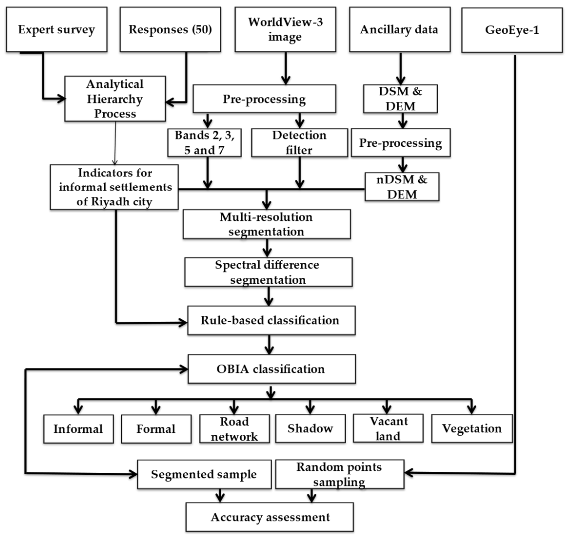
2. Materials and Methods
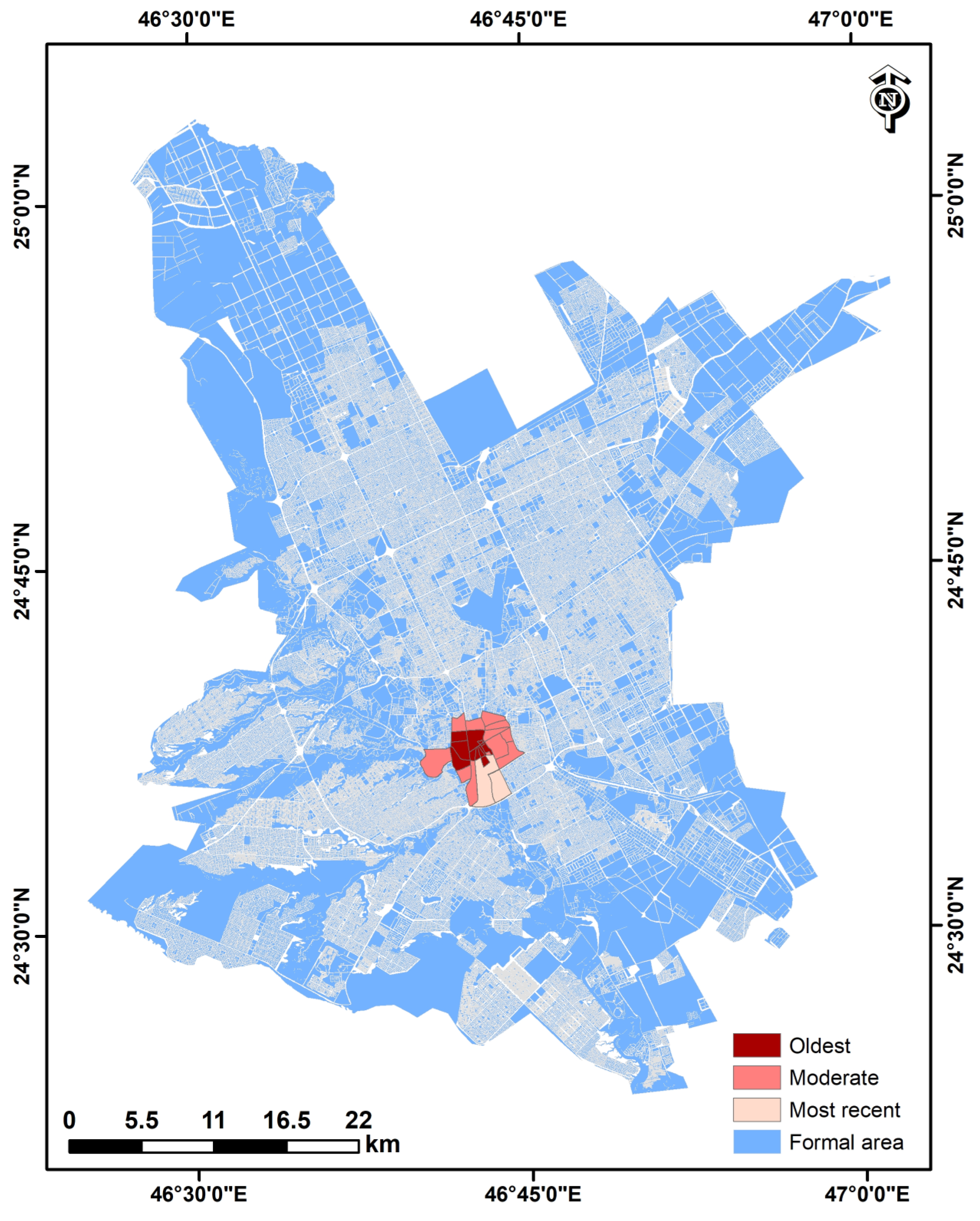
2.1. Study Area
2.2. Data and Image Pre-Processing
2.3. Ontological Framework
2.4. Expert Survey
2.5. Analytical Hierarchy Process (AHP)
2.6. OBIA Segmentation
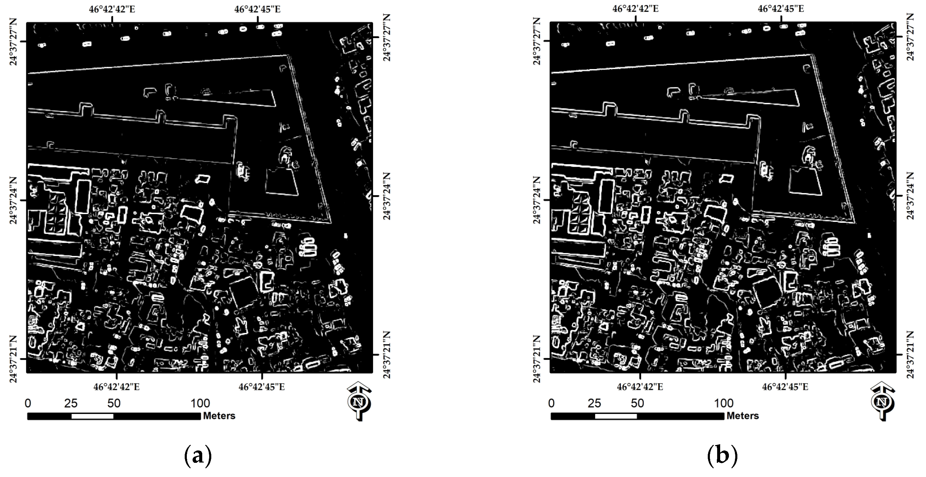
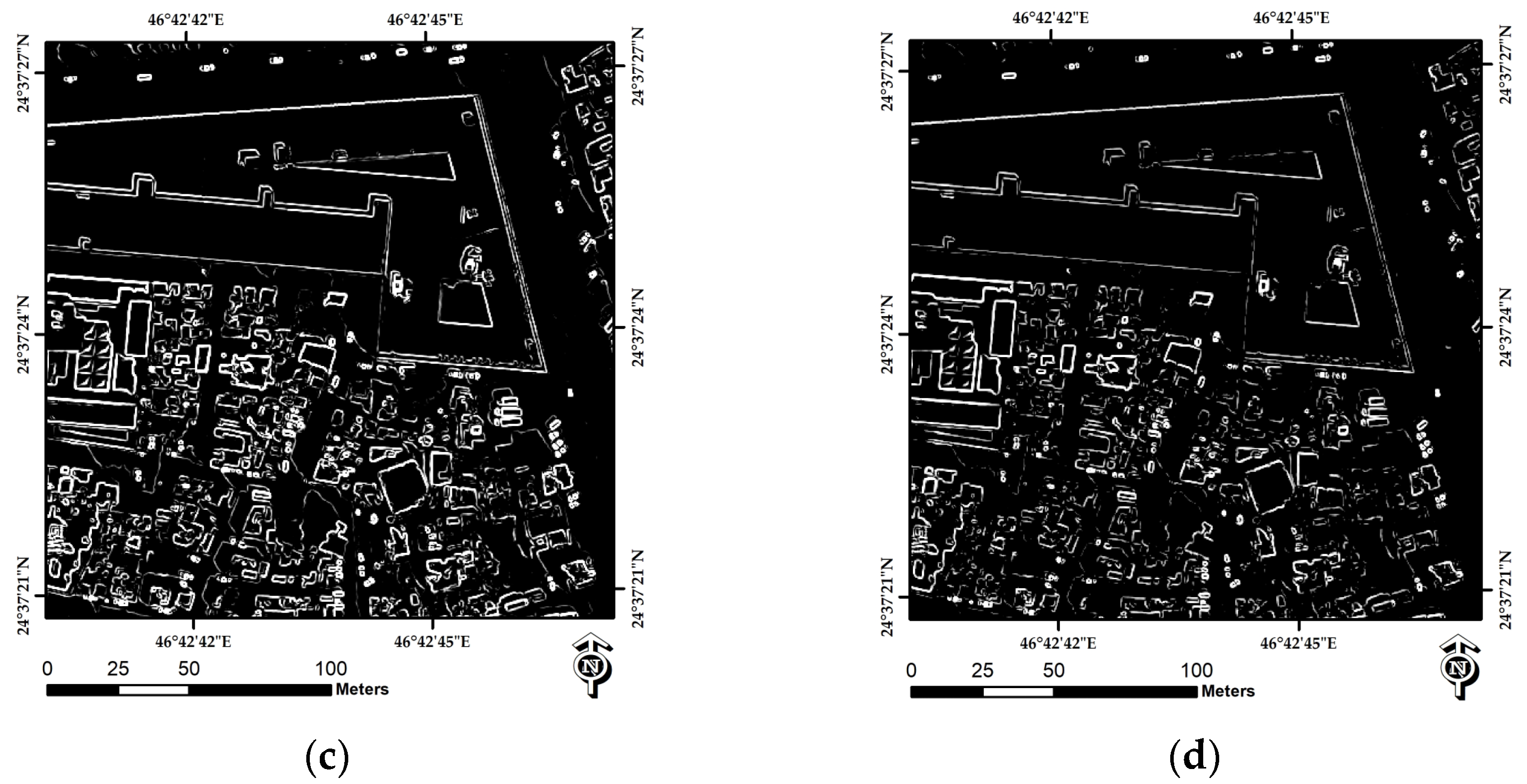
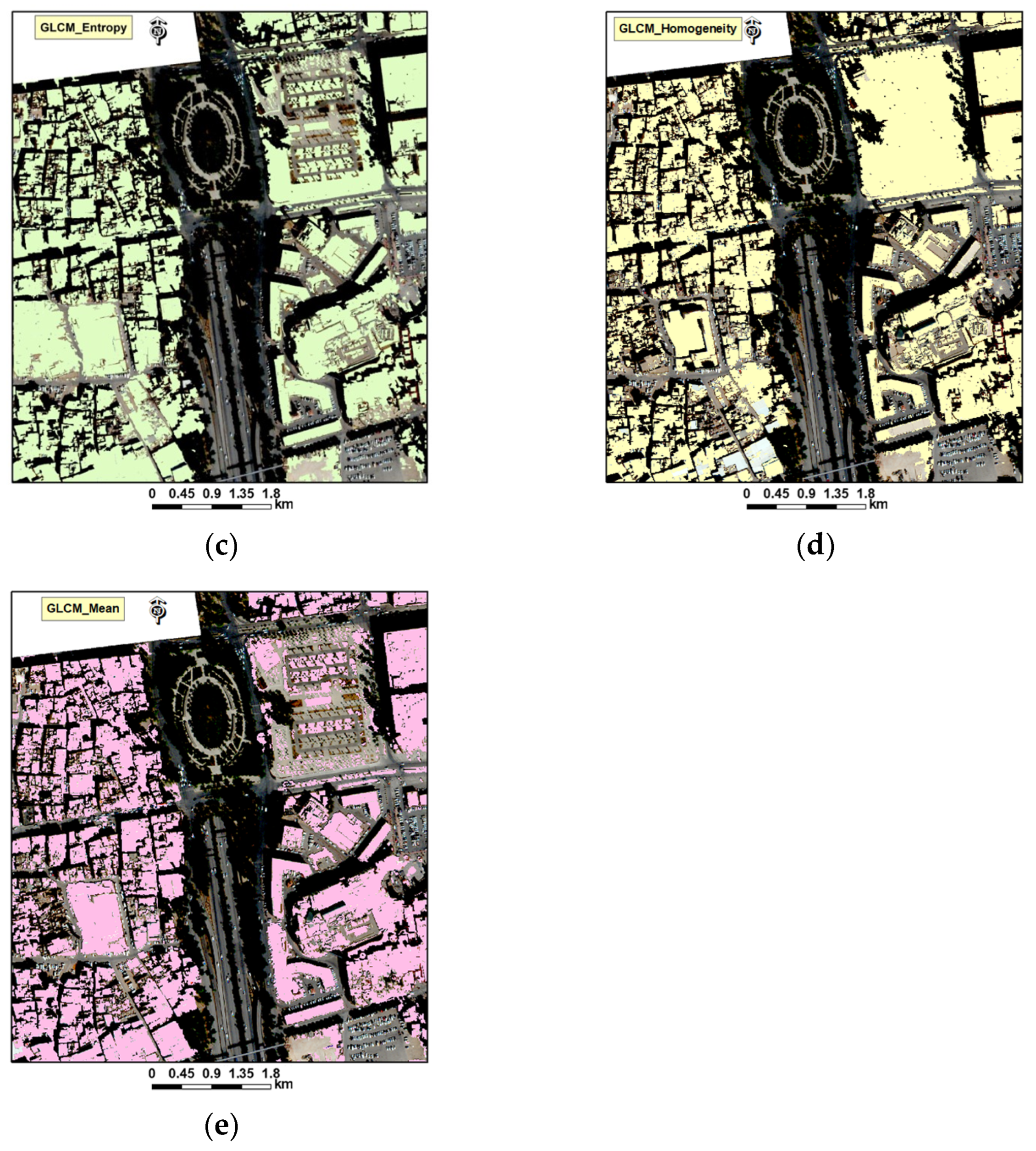
2.7. Indicators
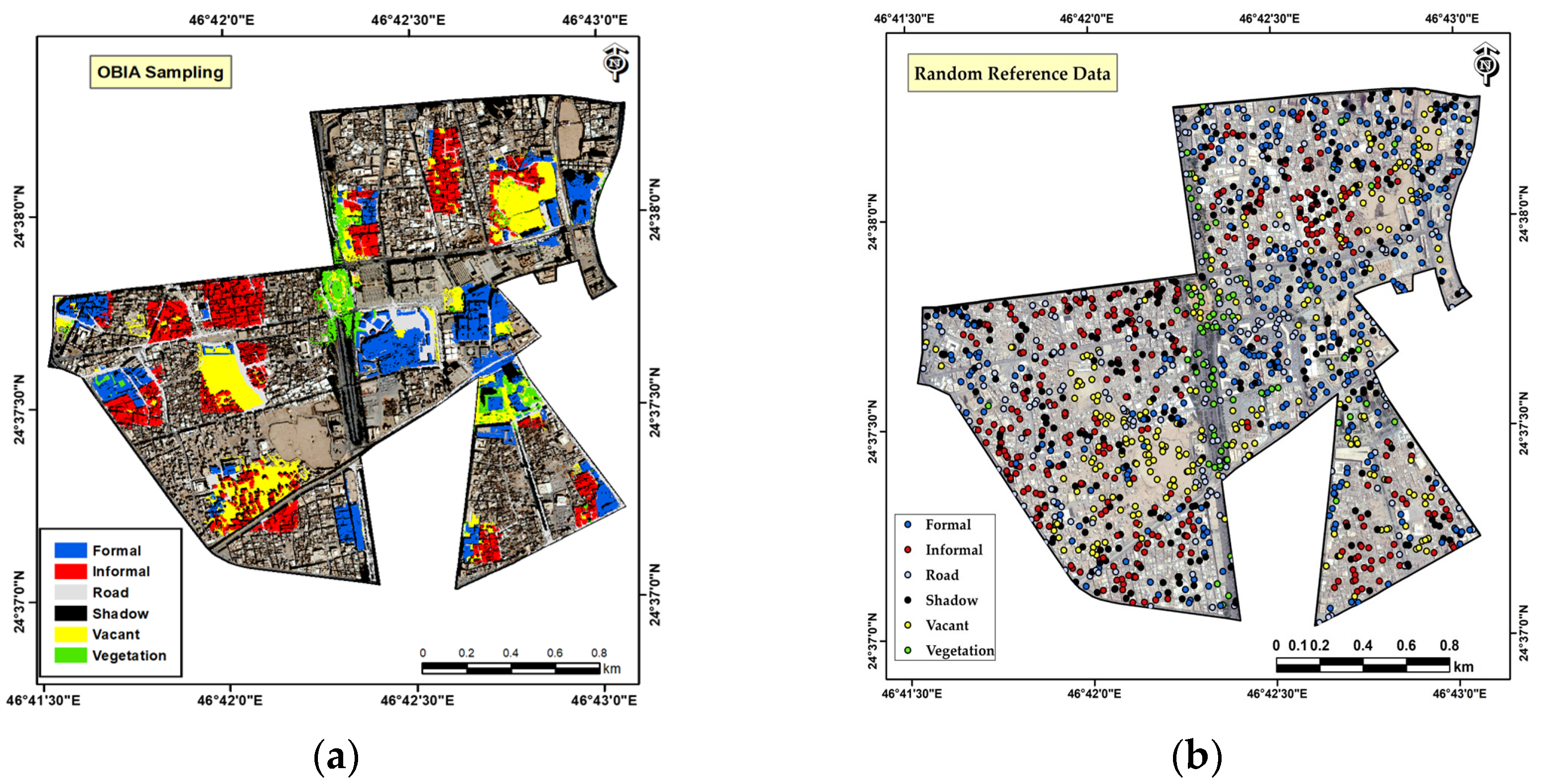
2.8. Accuracy Assessment
3. Results
3.1. Survey Assessment
3.2. AHP Assessment
3.2.1. Typical Site Conditions
3.2.2. Road Conditions
3.3. Local Ontology
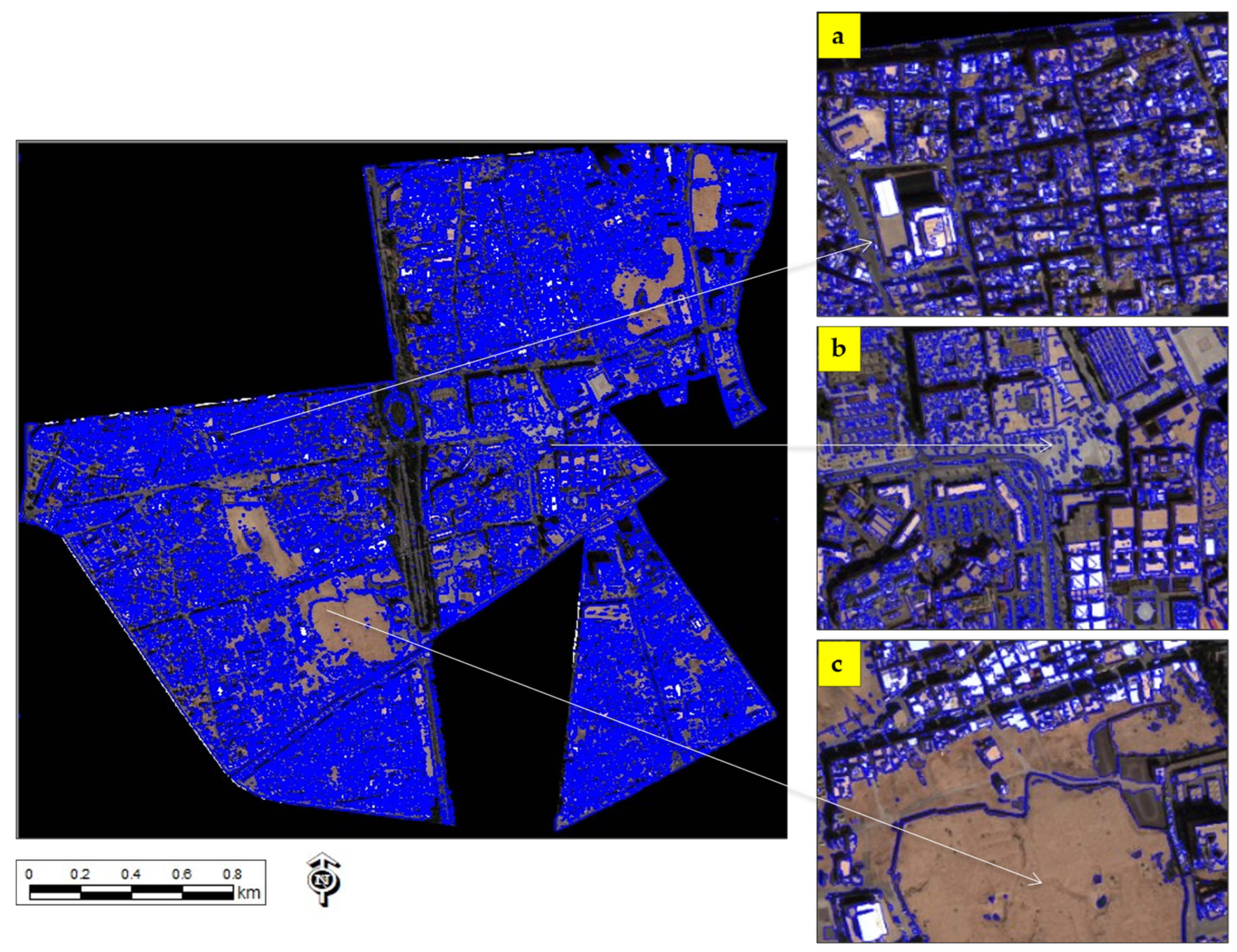
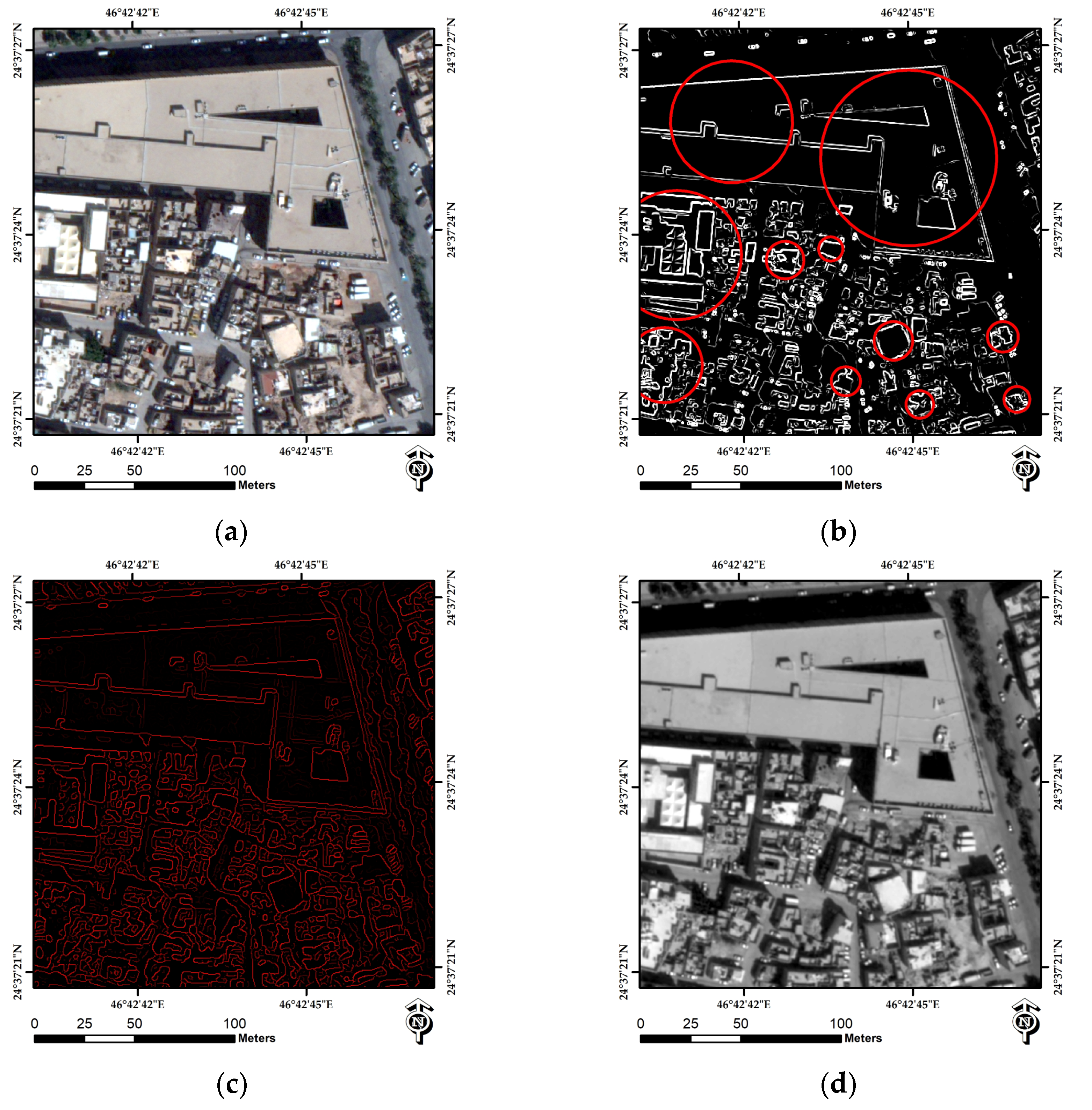
3.4. Segmentation
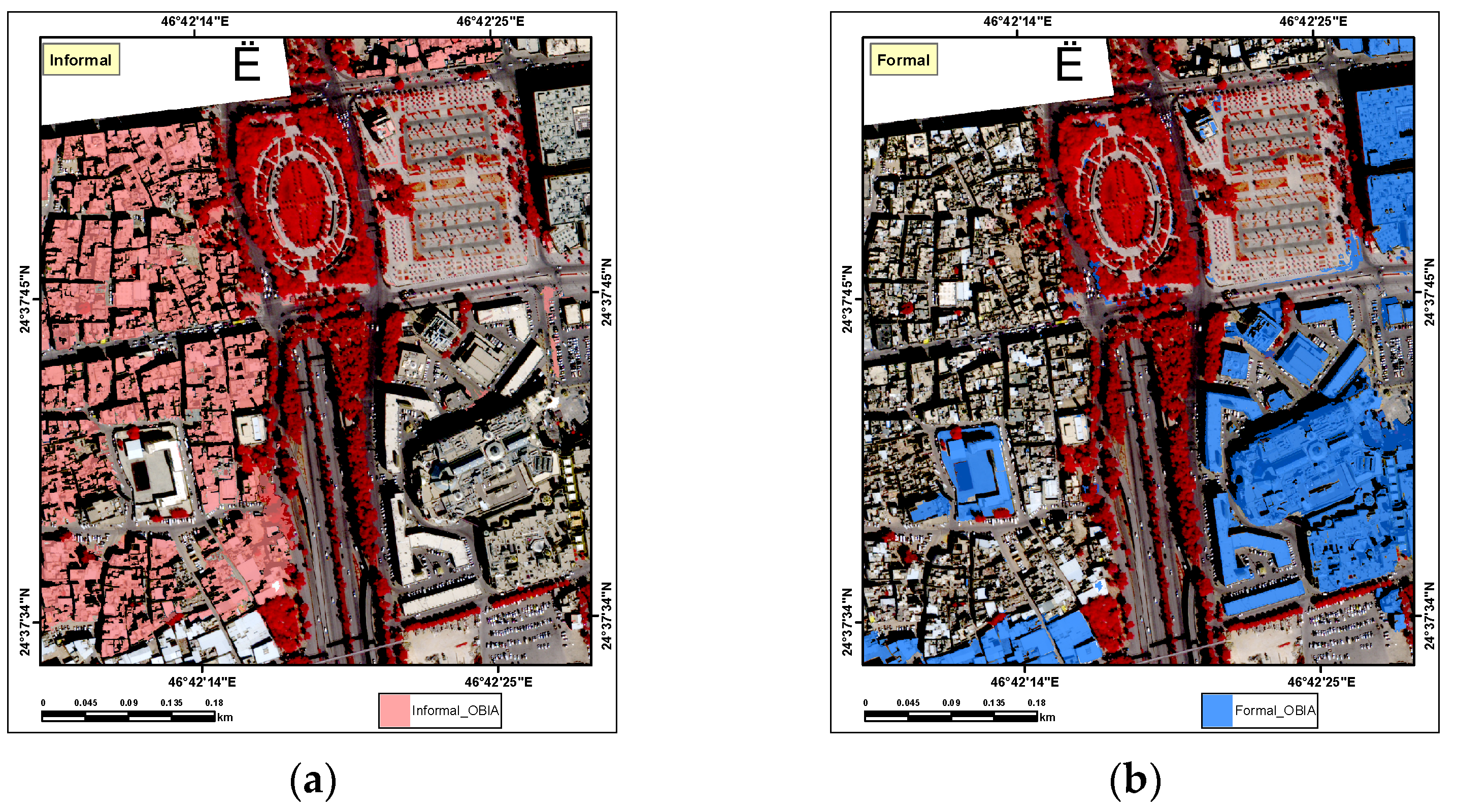
3.5. OBIA-Extracted Indicators
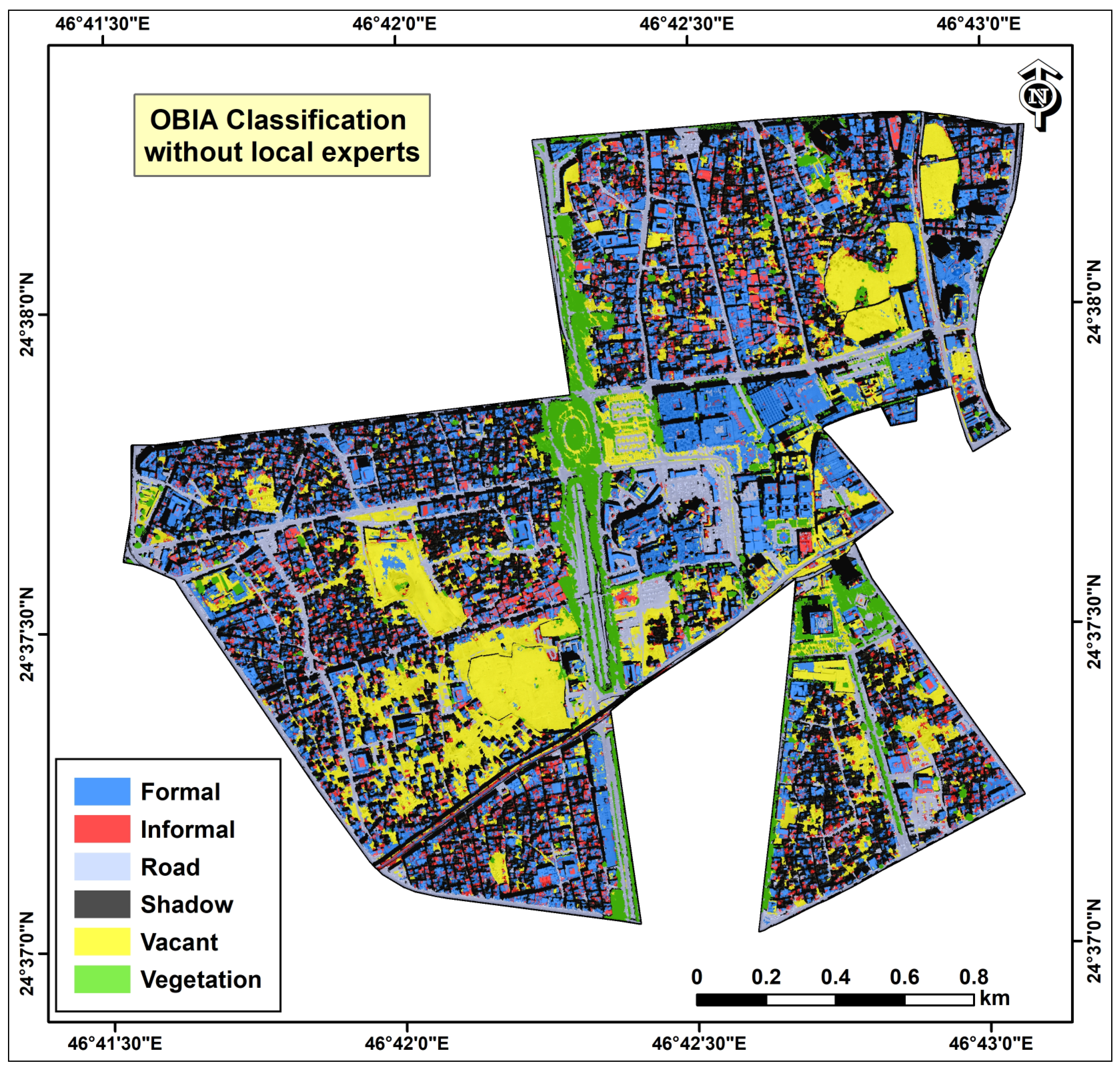
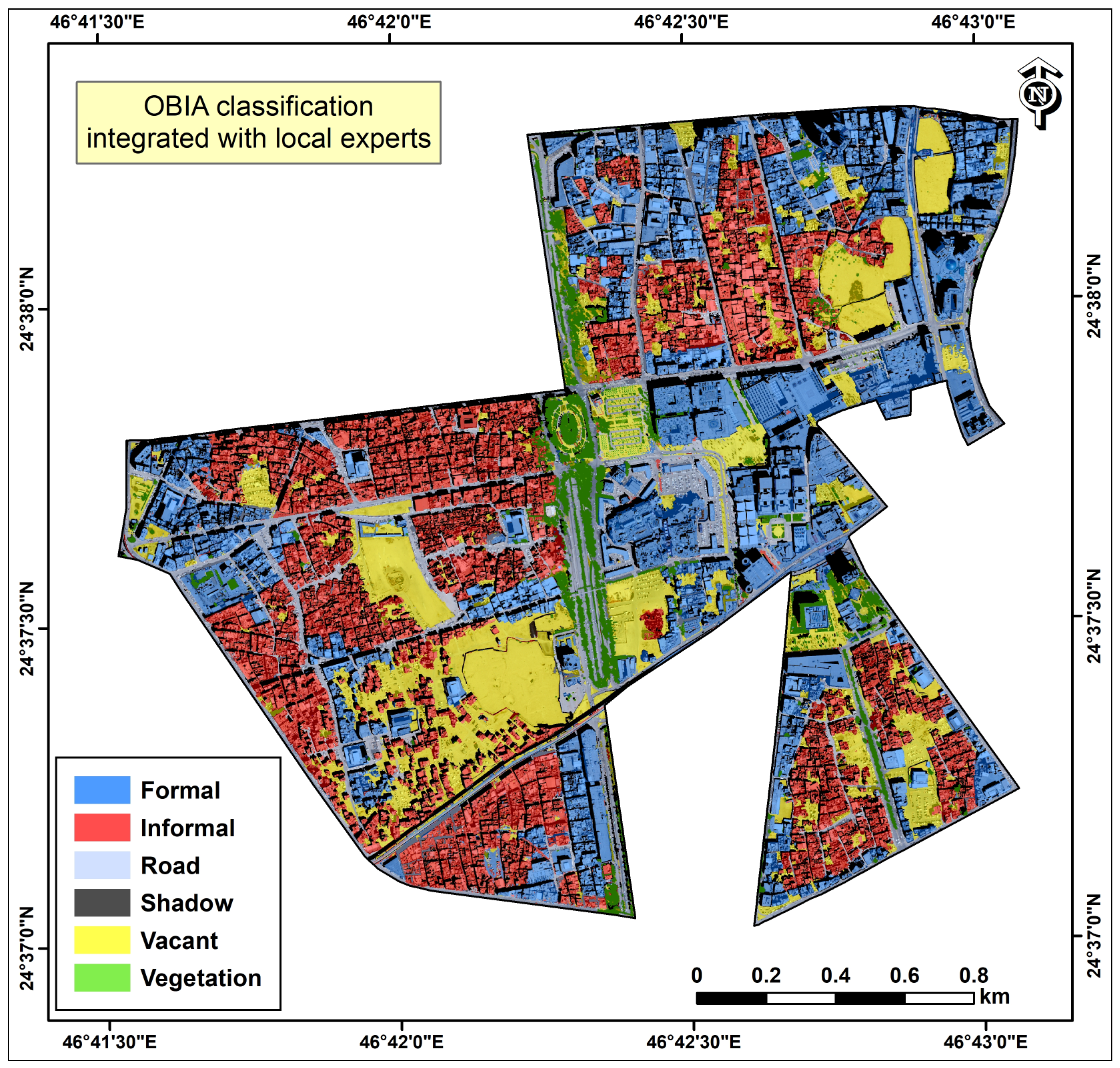
3.6. Accuracy Assessment
4. Discussion
5. Conclusions
Author Contributions
Funding
Acknowledgments
Conflicts of Interest
References
- Williams, D.S.; Manez Costa, M.; Sutherland, C.; Celliers, L.; Scheffran, J. Vulnerability of informal settlements in the context of rapid urbanization and climate change. Environ. Urban. 2019, 31, 157–176. [Google Scholar] [CrossRef] [Green Version]
- Moreno, E.L. Slums of the World: The Face of Urban Poverty in the New Millennium?: Monitoring the Millennium Development Goal, Target 11–World-Wide Slum Dweller Estimation; Un-Habitat: Nairobi, Kenya, 2003. [Google Scholar]
- Khraif, R.; Salam, A.A.; Al-Ayeen, J.; Abdul, M.F. Residential Satisfaction in Shantytowns of Riyadh City, Saudi Arabia: Levels and Determinants. Glob. J. Res. Rev. 2018, 5. [Google Scholar] [CrossRef]
- Dewan, A.M.; Yamaguchi, Y. Effect of land cover changes on flooding: Example from Greater Dhaka of Bangladesh. Int. J. Geoinform. 2008, 4, 11–20. [Google Scholar] [CrossRef]
- UN-Habitat. Image Informal Settlement in the Arab Region: “Towards Arab Cities without Informal Settlements” Analysis and Prospects; UN-Habitat: Nairobi, Kenya, 2020. [Google Scholar]
- Samper, J.; Shelby, J.A.; Behary, D. The paradox of informal settlements revealed in an ATLAS of informality: Findings from mapping growth in the most common yet unmapped forms of urbanization. Sustainability 2020, 12, 9510. [Google Scholar] [CrossRef]
- Breengy, A.; Yusof, N.A. Building-Related Health Issues in an Unsustainable Neighbourhood—A Study of a Slum Area in Jeddah, Saudi Arabia. Arab. World Geogr. 2018, 21, 141–153. [Google Scholar] [CrossRef]
- Fallatah, A.; Jones, S.; Mitchell, D.; Kohli, D. Mapping informal settlement indicators using object-oriented analysis in the Middle East. Int. J. Digit. Earth 2019, 12, 802–824. [Google Scholar] [CrossRef]
- Karimi, K.; Parham, E. An Evidence Informed Approach to Developing an Adaptable Regeneration Programme for Declining Informal Settlements; Pontificia Universidad Católica de Chile: Santiago de Chile, Chile, 2012. [Google Scholar]
- Aljoufie, M.; Zuidgeest, M.; Brussel, M.; van Maarseveen, M. Spatial–temporal analysis of urban growth and transportation in Jeddah City, Saudi Arabia. Cities 2013, 31, 57–68. [Google Scholar] [CrossRef]
- Jehani, L.A. A Case Study of Slum Upgrading in Jeddah, Saudi Arabia, in Geography; South Dakota State University: Brookings, SD, USA, 2015. [Google Scholar]
- El Menshawy, A.; Shafik, S. Affordable housing as a method for informal settlements sustainable upgrading. Procedia-Soc. Behav. Sci. 2016, 223, 126–133. [Google Scholar] [CrossRef] [Green Version]
- Haralick, R.M.; Shanmugam, K.; Dinstein, I.H. Textural features for image classification. IEEE Trans. Syst. Man Cybern. 1973, 610–621. [Google Scholar] [CrossRef] [Green Version]
- Kuffer, M.; Pfeffer, K.; Sliuzas, R. Slums from space—15 years of slum mapping using remote sensing. Remote Sens. 2016, 8, 455. [Google Scholar] [CrossRef] [Green Version]
- Matarira, D.; Mutanga, O.; Naidu, M.; Vizzari, M. Object-Based Informal Settlement Mapping in Google Earth Engine Using the Integration of Sentinel-1, Sentinel-2, and PlanetScope Satellite Data. Land 2022, 12, 99. [Google Scholar] [CrossRef]
- Mahabir, R.; Croitoru, A.; Crooks, A.T.; Agouris, P.; Stefanidis, A. A critical review of high and very high-resolution remote sensing approaches for detecting and mapping slums: Trends, challenges and emerging opportunities. Urban Sci. 2018, 2, 8. [Google Scholar] [CrossRef] [Green Version]
- Prabhu, R.; Alagu Raja, R. Urban slum detection approaches from high-resolution satellite data using statistical and spectral based approaches. J. Indian Soc. Remote Sens. 2018, 46, 2033–2044. [Google Scholar] [CrossRef]
- Kuffer, M.; Pfeffer, K.; Sliuzas, R.; Baud, I. Extraction of slum areas from VHR imagery using GLCM variance. IEEE J. Sel. Top. Appl. Earth Obs. Remote Sens. 2016, 9, 1830–1840. [Google Scholar] [CrossRef]
- Matarira, D.; Mutanga, O.; Naidu, M. Texture analysis approaches in modelling informal settlements: A review. Geocarto Int. 2022, 37, 13451–13478. [Google Scholar] [CrossRef]
- Mudau, N.; Mhangara, P. Investigation of Informal Settlement Indicators in a Densely Populated Area Using Very High Spatial Resolution Satellite Imagery. Sustainability 2021, 13, 4735. [Google Scholar] [CrossRef]
- Blaschke, T. Object based image analysis for remote sensing. ISPRS J. Photogramm. Remote Sens. 2010, 65, 2–16. [Google Scholar] [CrossRef] [Green Version]
- Wei, C.; Blaschke, T. Pixel-wise vs. object-based impervious surface analysis from remote sensing: Correlations with land surface temperature and population density. Urban Sci. 2018, 2, 2. [Google Scholar] [CrossRef] [Green Version]
- Kohli, D.; Stein, A.; Sliuzas, R. Uncertainty analysis for image interpretations of urban slums. Comput. Environ. Urban Syst. 2016, 60, 37–49. [Google Scholar] [CrossRef]
- Kohli, D.; Warwadekar, P.; Kerle, N.; Sliuzas, R.; Stein, A. Transferability of object-oriented image analysis methods for slum identification. Remote Sens. 2013, 5, 4209–4228. [Google Scholar] [CrossRef] [Green Version]
- Chang, Z.; Du, Z.; Zhang, F.; Huang, F.; Chen, J.; Li, W.; Guo, Z. Landslide susceptibility prediction based on remote sensing images and GIS: Comparisons of supervised and unsupervised machine learning models. Remote Sens. 2020, 12, 502. [Google Scholar] [CrossRef] [Green Version]
- Kuffer, M.; Barros, J.; Sliuzas, R.V. The development of a morphological unplanned settlement index using very-high-resolution (VHR) imagery. Comput. Environ. Urban Syst. 2014, 48, 138–152. [Google Scholar] [CrossRef]
- Ghaffarian, S.; Emtehani, S. Monitoring urban deprived areas with remote sensing and machine learning in case of disaster recovery. Climate 2021, 9, 58. [Google Scholar] [CrossRef]
- Kohli, D.; Sliuzas, R.; Kerle, N.; Stein, A. An ontology of slums for image-based classification. Comput. Environ. Urban Syst. 2012, 36, 154–163. [Google Scholar] [CrossRef]
- Jovanović, D.; Gavrilović, M.; Sladić, D.; Radulović, A.; Govedarica, M. Building Change Detection Method to Support Register of Identified Changes on Buildings. Remote Sens. 2021, 13, 3150. [Google Scholar] [CrossRef]
- Grippa, T.; Georganos, S.; Lennert, M.; Vanhuysse, S.; Wolff, E. A local segmentation parameter optimization approach for mapping heterogeneous urban environments using VHR imagery. In Remote Sensing Technologies and Applications in Urban Environments II; SPIE: Bellingham, DC, USA, 2017. [Google Scholar] [CrossRef]
- Rousseau, D.; Billingham, J.; Calvo-Amodio, J. Systemic semantics: A systems approach to building ontologies and concept maps. Systems 2018, 6, 32. [Google Scholar] [CrossRef] [Green Version]
- Pratomo, J.; Kuffer, M.; Martinez, J.; Kohli, D. Coupling uncertainties with accuracy assessment in object-based slum detections, case study: Jakarta, Indonesia. Remote Sens. 2017, 9, 1164. [Google Scholar] [CrossRef] [Green Version]
- Kohli, D.; Kuffer, M.; Gevaert, C.M. The Generic Slum Ontology: Can a Global Slum Repository be created? In Proceedings of the 2019 Joint Urban Remote Sensing Event (JURSE), Vannes, France, 22–24 May 2019. [Google Scholar] [CrossRef]
- Prabhu, R.; Parvathavarthini, B.; Alagu Raja, R. Slum extraction from high resolution satellite data using mathematical morphology based approach. Int. J. Remote Sens. 2021, 42, 172–190. [Google Scholar] [CrossRef]
- Owen, K.K.; Wong, D.W. An approach to differentiate informal settlements using spectral, texture, geomorphology and road accessibility metrics. Appl. Geogr. 2013, 38, 107–118. [Google Scholar] [CrossRef]
- Pratomo, J.; Kuffer, M.; Kohli, D.; Martinez, J. Application of the trajectory error matrix for assessing the temporal transferability of OBIA for slum detection. Eur. J. Remote Sens. 2018, 51, 838–849. [Google Scholar] [CrossRef] [Green Version]
- Kuffer, M.; Pfeffer, K.; Persello, C. Special issue “remote-sensing-based urban planning indicators”. Remote Sens. 2021, 13, 1264. [Google Scholar] [CrossRef]
- Aldana-Martín, J.F.; García-Nieto, J.; del Mar Roldán-García, M.; Aldana-Montes, J.F. Semantic modelling of Earth Observation remote sensing. Expert Syst. Appl. 2022, 187, 115838. [Google Scholar] [CrossRef]
- Arvor, D.; Belgiu, M.; Falomir, Z.; Mougenot, I.; Durieux, L. Ontologies to interpret remote sensing images: Why do we need them? GIScience Remote Sens. 2019, 56, 911–939. [Google Scholar] [CrossRef] [Green Version]
- Hertog, S. The Political Economy of Regional Development in Post-World War II Saudi Arabia; Cambridge University Press: New York, NY, USA, 2015. [Google Scholar]
- Alotaibi, A.; Alsubaie, D.; Alaskar, H.; Alhumaid, L.; Thuwayni, R.B.; Alkhalifah, R.; Alhumoud, S. Kingdom of Saudi Arabia: Era of Smart Cities. In Proceedings of the 2022 2nd International Conference on Computing and Information Technology (ICCIT), Tabuk, Saudi Arabia, 25–27 January 2022. [Google Scholar] [CrossRef]
- Khraif, R.M. The Labor Force in Saudi Arabia: Spatial Dimensions and Socioeconomic and Demographic Characteristics; Saudi Geographical Society: Riyadh, Saudi Arabia, 2000. [Google Scholar]
- Alshuwaikhat, H.M.; Adenle, Y.A.; Almuhaidib, T. A Lifecycle-Based Smart Sustainable City Strategic Framework for Realizing Smart and Sustainability Initiatives in Riyadh City. Sustainability 2022, 14, 8240. [Google Scholar] [CrossRef]
- Laben, C.A.; Brower, B.V. Process for Enhancing the Spatial Resolution of Multispectral Imagery Using Pan-Sharpening. U.S. Patent 6,011,875, 4 January 2000. [Google Scholar]
- Duque, J.C.; Patino, J.E.; Betancourt, A. Exploring the potential of machine learning for automatic slum identification from VHR imagery. Remote Sens. 2017, 9, 895. [Google Scholar] [CrossRef] [Green Version]
- Schmitt, A.; Sieg, T.; Wurm, M.; Taubenböck, H. Investigation on the separability of slums by multi-aspect TerraSAR-X dual-co-polarized high resolution spotlight images based on the multi-scale evaluation of local distributions. Int. J. Appl. Earth Obs. Geoinf. 2018, 64, 181–198. [Google Scholar] [CrossRef] [Green Version]
- Sowa, J.F. Knowledge Representation: Logical, Philosophical and Computational Foundations; Brooks/Cole Publishing Co.: Pacific Grove, CA, USA, 1999. [Google Scholar]
- Saaty, T. The Analytic Hierarchy Process (AHP) for Decision Making; Kobe, Japan. 1980. Available online: http://www.cashflow88.com/decisiones/saaty1.pdf (accessed on 8 June 2023).
- Drǎguţ, L.; Tiede, D.; Levick, S.R. ESP: A tool to estimate scale parameter for multiresolution image segmentation of remotely sensed data. Int. J. Geogr. Inf. Sci. 2010, 24, 859–871. [Google Scholar] [CrossRef] [Green Version]
- Kohli, D.; Sliuzas, R.; Stein, A. Urban slum detection using texture and spatial metrics derived from satellite imagery. J. Spat. Sci. 2016, 61, 405–426. [Google Scholar] [CrossRef] [Green Version]
- Warth, G.; Braun, A.; Assmann, O.; Fleckenstein, K.; Hochschild, V. Prediction of socio-economic indicators for urban planning using VHR satellite imagery and spatial analysis. Remote Sens. 2020, 12, 1730. [Google Scholar] [CrossRef]
- Qian, Y.; Zhou, W.; Yan, J.; Li, W.; Han, L. Comparing machine learning classifiers for object-based land cover classification using very high resolution imagery. Remote Sens. 2014, 7, 153–168. [Google Scholar] [CrossRef] [Green Version]
- Huang, Y.; Zhuo, L.; Tao, H.; Shi, Q.; Liu, K. A novel building type classification scheme based on integrated LiDAR and high-resolution images. Remote Sens. 2017, 9, 679. [Google Scholar] [CrossRef] [Green Version]
- Asmat, A.; Zamzami, S. Automated house detection and delineation using optical remote sensing technology for informal human settlement. Procedia-Soc. Behav. Sci. 2012, 36, 650–658. [Google Scholar] [CrossRef] [Green Version]
- Ajami, A.; Kuffer, M.; Persello, C.; Pfeffer, K. Identifying a slums’ degree of deprivation from VHR images using convolutional neural networks. Remote Sens. 2019, 11, 1282. [Google Scholar] [CrossRef] [Green Version]
- Taubenböck, H.; Kraff, N.J.; Wurm, M. The morphology of the Arrival City—A global categorization based on literature surveys and remotely sensed data. Appl. Geogr. 2018, 92, 150–167. [Google Scholar] [CrossRef]
- Silva, C.; Bertolini, L.; Brömmelstroet, M.T.; Milakis, D.; Papa, E. Accessibility instruments in planning practice: Bridging the implementation gap. Transp. Policy 2017, 53, 135–145. [Google Scholar] [CrossRef] [Green Version]
- Andrés, S.; Arvor, D.; Mougenot, I.; Libourel, T.; Durieux, L. Ontology-based classification of remote sensing images using spectral rules. Comput. Geosci. 2017, 102, 158–166. [Google Scholar] [CrossRef]
- Han, R.; Liu, P.; Wang, G.; Zhang, H.; Wu, X. Advantage of combining OBIA and classifier ensemble method for very high-resolution satellite imagery classification. J. Sens. 2020, 2020, 8855509. [Google Scholar] [CrossRef]
- MacTavish, R.; Bixby, H.; Cavanaugh, A.; Agyei-Mensah, S.; Bawah, A.; Owusu, G.; Ezzati, M.; Arku, R.; Robinson, B.; Schmidt, A.M.; et al. Identifying deprived “slum” neighbourhoods in the Greater Accra Metropolitan Area of Ghana using census and remote sensing data. World Dev. 2023, 167, 106253. [Google Scholar] [CrossRef]
- Mudau, N.; Mhangara, P. Towards understanding informal settlement growth patterns: Contribution to SDG reporting and spatial planning. Remote Sens. Appl. Soc. Environ. 2022, 27, 100801. [Google Scholar] [CrossRef]
- Mahabir, R.; Crooks, A.; Croitoru, A.; Agouris, P. The study of slums as social and physical constructs: Challenges and emerging research opportunities. Reg. Stud. Reg. Sci. 2016, 3, 399–419. [Google Scholar] [CrossRef] [Green Version]
- Belgiu, M.; Dr, L.; Strobl, J. Quantitative evaluation of variations in rule-based classifications of land cover in urban neighbourhoods using WorldView-2 imagery. ISPRS J. Photogramm. Remote Sens. 2014, 87, 205–215. [Google Scholar] [CrossRef] [PubMed] [Green Version]
- Huang, X.; Liu, H.; Zhang, L. Spatiotemporal detection and analysis of urban villages in mega city regions of China using high-resolution remotely sensed imagery. IEEE Trans. Geosci. Remote Sens. 2015, 53, 3639–3657. [Google Scholar] [CrossRef]
- Hofmann, P.; Bekkarnayeva, G. Object-based change detection of informal settlements. In Proceedings of the 2017 Joint Urban Remote Sensing Event (JURSE), Dubai, United Arab Emirates, 6–8 March 2017. [Google Scholar] [CrossRef]
- Mugiraneza, T.; Nascetti, A.; Ban, Y. WorldView-2 data for hierarchical object-based urban land cover classification in kigali: Integrating rule-based approach with urban density and greenness indices. Remote Sens. 2019, 11, 2128. [Google Scholar] [CrossRef] [Green Version]


| Data | Image Attributes | Band | Spectral Resolution | Ground Sampling Distance (GSD) | Source |
|---|---|---|---|---|---|
| WorldView-3 | Panchromatic Band | Panchromatic | 450–800 nm | 0.30 m GSD at nadir 0.34 m at 20° off-nadir | KACST |
| MS (multispectral) bands and VNIR (visible near-infrared) | Coastal Blue | 400–450 nm | 1.24 m at nadir, 1.38 m at 20° off-nadir | ||
| Blue | 450–510 nm | ||||
| Green | 510–580 nm | ||||
| Yellow | 585–625 nm | ||||
| Red | 630–690 nm | ||||
| Red edge | 705–745 nm | ||||
| Near-infrared1 | 770–895 nm | ||||
| Near-infrared2 | 400–450 nm | ||||
| Acquisition date | 8 June 2021 | ||||
| Swath width | 13.1 km | ||||
| Total cloud cover | 0% | ||||
| GeoEye-1 | Panchromatic | Panchromatic | 450–900 nm | 0.41 m GSD | KACST |
| MS and NIR | blue | 450–510 nm | 1.64 m GSD | ||
| green | 520–580 nm | ||||
| red | 655–690 nm | ||||
| Near-infrared | 780–900 nm | ||||
| Acquis. date | 17 February 2021 | ||||
| Swath width | 15.2 km | ||||
| Total cloud cover | 0% | ||||
| DEM and DSM | Spatial resolution | 5 m | KACST | ||
| Coverage | 3.5 km2 |
| Indicators | Description | Definition |
|---|---|---|
| NDVI | Normalized difference vegetation index | Measures vegetation |
| VB | Visible brightness | Measures roads |
| SD (B) | Standard deviation (Blue) band | Measures how dispersed the data are concerning the to mean brightness of band 2 |
| DSM | Roof | Digital surface model |
| GCLM texture | Entropy | Measures randomness to detect the texture of an input image |
| Contrast | Measures the local variations in the GLCM through the intensity contrast between a pixel and its whole neighbor | |
| Homogeneity | High value, if GLCM concentrates along the diagonal | |
| Correlation | Values range between −1 and 1 | |
| Mean | Pixel value is weighted by the frequency of its occurrence in combination with a certain neighboring value | |
| BI | Border index | Percentage of the image border length between the object and the smallest enclosing rectangle |
| MDS (B) | Mean and standard deviations (blue band) | Digital number values of a blue band and all pixels |
| Dwelling size | Pixel size (area) | The size of an image object is measured by the number of pixels in the image |
| Dwelling shape | Shape index | The smoothness of an image object border |
| Building density | Density | The image object that contains the current candidate pixel/voxel |
| Housing orientation | Accessibility | The corner of the object that is used as the calculation base for the coordinates |
| Proximity to hazardous areas (e.g., flooding, landslides) | DEM | Slope |
| Indicators | Number of Experts (n = 50) | Tolerance | VIF |
|---|---|---|---|
| Structure of the informal settlement (planned area) | 11 | ||
| Structure of the informal settlement (unplanned area) | 39 | ||
| Timeline—gradual over a long period | 39 | 0.616 | 1.622 |
| >20% vegetation | 41 | 0.773 | 1.293 |
| Roof material (concrete/mud) | 46 | 0.523 | 1.913 |
| Steep slope | 4 | 0.378 | 2.646 |
| Proximity to social services | 32 | 0.726 | 1.377 |
| Proximity to hazardous industries | 14 | 0.480 | 2.082 |
| Narrow road | 24 | 0.622 | 1.607 |
| Curved road | 4 | 0.613 | 1.630 |
| Straight road | 6 | 0.684 | 1.463 |
| Paved road | 2 | 0.727 | 1.376 |
| Short segments with abundant crossroads and paths | 10 | 0.587 | 1.705 |
| Building size ≤280 m2 | 48 | 0.521 | 1.918 |
| Criteria | Proximity to Hazardous Industries | Proximity to Social Services | Steep Slope |
|---|---|---|---|
| Proximity to hazardous industry | 1.00 | 0.33 | 5.00 |
| Proximity to social services | 3.00 | 1.00 | 7.00 |
| Steep slope | 0.20 | 0.14 | 1.00 |
| Total | 4.20 | 1.48 | 13.00 |
| Normalized Matrix | Proximity to Hazardous Industries | Proximity to Social Services | Steep Slope | Sum | Priority Criteria |
|---|---|---|---|---|---|
| Proximity to hazardous industry | 0.238 | 0.226 | 0.385 | 0.849 | 28.28% |
| Proximity to social services | 0.714 | 0.677 | 0.538 | 1.930 | 64.34% |
| Steep slope | 0.048 | 0.097 | 0.077 | 0.221 | 7.38% |
| Total | 1.000 | 1.000 | 1.000 | 3.000 | 100.0% |
| Criteria | Narrow Roads | A Lot of Crossings with Short Segments | Straight Roads | Curved Roads | Paved Roads |
|---|---|---|---|---|---|
| Narrow roads | 1.00 | 3.00 | 5.00 | 6.00 | 7.00 |
| Crossings with short segments | 0.33 | 1.00 | 2.00 | 3.00 | 5.00 |
| Straight roads | 0.20 | 0.50 | 1.00 | 2.00 | 4.00 |
| Curved roads | 0.17 | 0.33 | 0.50 | 1.00 | 3.00 |
| Paved roads | 0.14 | 0.20 | 0.25 | 0.33 | 1.00 |
| Total | 1.84 | 5.03 | 8.75 | 12.33 | 20.00 |
| Normalized Matrix | Narrow Roads | A Lot of Crossings with Short Segments | Straight Roads | Curved Roads | Paved Roads | Sum | Priority Criteria |
|---|---|---|---|---|---|---|---|
| Narrow roads | 0.543 | 0.596 | 0.571 | 0.486 | 0.350 | 2.547 | 50.93% |
| A lot of crossings with short segments | 0.181 | 0.199 | 0.229 | 0.243 | 0.250 | 1.101 | 22.03% |
| Straight roads | 0.109 | 0.099 | 0.114 | 0.162 | 0.200 | 0.684 | 13.69% |
| Curved roads | 0.090 | 0.066 | 0.057 | 0.081 | 0.150 | 0.445 | 8.90% |
| Paved roads | 0.078 | 0.040 | 0.029 | 0.027 | 0.050 | 0.223 | 4.46% |
| Total | 1.000 | 1.000 | 1.000 | 1.000 | 1.000 | 5.000 | 100.0% |
| Level | LOIS | Indicators | Local Expert Index for Riyadh | OBIA |
|---|---|---|---|---|
| Object Level | Accessibility | Shape | Irregular | Varies according to the straightness of the road |
| Type | Paved/unpaved roads | >6 m—many paths with short segments | ||
| width | Narrow road | |||
| Buildings | Building size | >280 m2 | Geometry—asymmetry | |
| Material type | Roof material concrete | Spectral mean value | ||
| Settlements | Shape | Pattern | Irregular shape, elongated shape along linear features | Geometry—buffer around the roads |
| Density | Texture | Roof coverage | Texture—entropy | |
| Amount of vegetation ≥20% | Texture—contrast, homogeneity, correlation, mean of built-up area | |||
| Vacant | ||||
| Environs | Neighbourhood | Pattern | Proximity to social services | Geometry—buffer around roads |
| Location | Proximity to hazardous industries, steep slopes |
| Indices | Description | Min | Max | Average with Mean |
|---|---|---|---|---|
| NDVI | Normalized difference vegetation index | 0.01 | 1 | 0.05 |
| VB | Visible brightness | 0 | 1250 | 328 |
| SD (B) | Standard Deviation (Blue) Band | 32 | 60 | 46 |
| DSM | Roof | 568 | 613 | 590 |
| GCLM texture | Entropy | 0 | 7.9 | 4 |
| Contrast | 1230 | 6790 | 4000 | |
| Homogeneity | 0 | 0.05 | 0.025 | |
| Correlation | 0 | 0.81 | 0.4 | |
| Mean | 40 | 126 | 83 | |
| BI | Border index | 8 | 3 | 11 |
| MDS (B) | Mean and standard deviation of the blue band | 37 | 49 | 58 |
| Dwelling size | Pixel size (area) | >70 pixel | 8 | 1027 |
| Dwelling shape | Shape index | 0 | 2 | 1 |
| Building density | Density | 0.9 | 1.3 | 1.1 |
| Housing orientation | Accessibility | 0.48 | 0.99 | 0.73 |
| Proximity to hazardous locations (e.g., possible floods, landslides) | DEM | 0 | 200 m |
| Class | Objects | Formal | Informal | Road | Shadow | Vacant | Vegetation | Total | User Accuracy |
|---|---|---|---|---|---|---|---|---|---|
| Formal | 36,283 | 894 | 9 | 5 | 1 | 4 | 2 | 915 | 0.98 |
| Informal | 25,551 | 23 | 352 | 3 | 1 | 0.00 | 0.00 | 379 | 0.93 |
| Road | 12,207 | 10 | 5 | 86 | 2 | 0.00 | 1 | 104 | 0.83 |
| Shadow | 9368 | 6 | 2 | 0.00 | 17 | 0.00 | 0.00 | 25 | 0.68 |
| Vacant | 15,710 | 8 | 1 | 0.00 | 1 | 10 | 0.00 | 20 | 0.50 |
| Vegetation | 1114 | 3 | 0.00 | 0.00 | 0.00 | 0.00 | 54 | 57 | 0.95 |
| Total | 100,233 | 944 | 369 | 94.00 | 22 | 14 | 57 | 1500 | 0.00 |
| Producer accuracy | 0.95 | 0.95 | 0.91 | 0.77 | 0.71 | 0.95 | 0.00 | 0.94 |
| Class | Object | Formal | Informal | Road | Shadow | Vacant | Vegetation | Total | User Accuracy |
|---|---|---|---|---|---|---|---|---|---|
| Formal | 22,491 | 195 | 55 | 28 | 27 | 22 | 6 | 333 | 0.59 |
| Informal | 17,825 | 53 | 102 | 9 | 16 | 9 | 2 | 191 | 0.53 |
| Road | 9258 | 14 | 14 | 137 | 22 | 12 | 5 | 204 | 0.67 |
| Shadow | 11,817 | 22 | 16 | 11 | 301 | 2 | 15 | 367 | 0.82 |
| Vacant | 12,647 | 25 | 27 | 33 | 20 | 204 | 9 | 318 | 0.64 |
| Vegetation | 783 | 0 | 0 | 0 | 2 | 0 | 85 | 87 | 0.97 |
| Total | 74,821 | 309 | 214 | 218 | 388 | 249 | 122 | 1500 | 0 |
| Producer accuracy | 0.63 | 0.47 | 0.92 | 0.77 | 0.81 | 0.69 | 0 | 0.68 |
| With EK | Without EK | |||
|---|---|---|---|---|
| Class | Area (km2) | Percentage (%) | Area (km2) | Percentage (%) |
| Formal | 0.83 | 0.24 | 0.8 | 0.24 |
| Informal | 0.72 | 0.21 | 0.26 | 0.07 |
| Roads | 0.51 | 0.15 | 0.53 | 0.15 |
| Shadow | 0.68 | 0.19 | 1.11 | 0.32 |
| Vacant | 0.59 | 0.17 | 0.57 | 0.16 |
| Vegetation | 0.15 | 0.04 | 0.22 | 0.06 |
Disclaimer/Publisher’s Note: The statements, opinions and data contained in all publications are solely those of the individual author(s) and contributor(s) and not of MDPI and/or the editor(s). MDPI and/or the editor(s) disclaim responsibility for any injury to people or property resulting from any ideas, methods, instructions or products referred to in the content. |
© 2023 by the authors. Licensee MDPI, Basel, Switzerland. This article is an open access article distributed under the terms and conditions of the Creative Commons Attribution (CC BY) license (https://creativecommons.org/licenses/by/4.0/).
Share and Cite
Alrasheedi, K.G.; Dewan, A.; El-Mowafy, A. Using Local Knowledge and Remote Sensing in the Identification of Informal Settlements in Riyadh City, Saudi Arabia. Remote Sens. 2023, 15, 3895. https://doi.org/10.3390/rs15153895
Alrasheedi KG, Dewan A, El-Mowafy A. Using Local Knowledge and Remote Sensing in the Identification of Informal Settlements in Riyadh City, Saudi Arabia. Remote Sensing. 2023; 15(15):3895. https://doi.org/10.3390/rs15153895
Chicago/Turabian StyleAlrasheedi, Khlood Ghalib, Ashraf Dewan, and Ahmed El-Mowafy. 2023. "Using Local Knowledge and Remote Sensing in the Identification of Informal Settlements in Riyadh City, Saudi Arabia" Remote Sensing 15, no. 15: 3895. https://doi.org/10.3390/rs15153895
APA StyleAlrasheedi, K. G., Dewan, A., & El-Mowafy, A. (2023). Using Local Knowledge and Remote Sensing in the Identification of Informal Settlements in Riyadh City, Saudi Arabia. Remote Sensing, 15(15), 3895. https://doi.org/10.3390/rs15153895