TerraSAR-X and GNSS Data for Deformation Detection and Mechanism Analysis of a Deep Excavation Channel Section of the China South–North Water-Diversion Project
Abstract
:1. Introduction
2. Methods
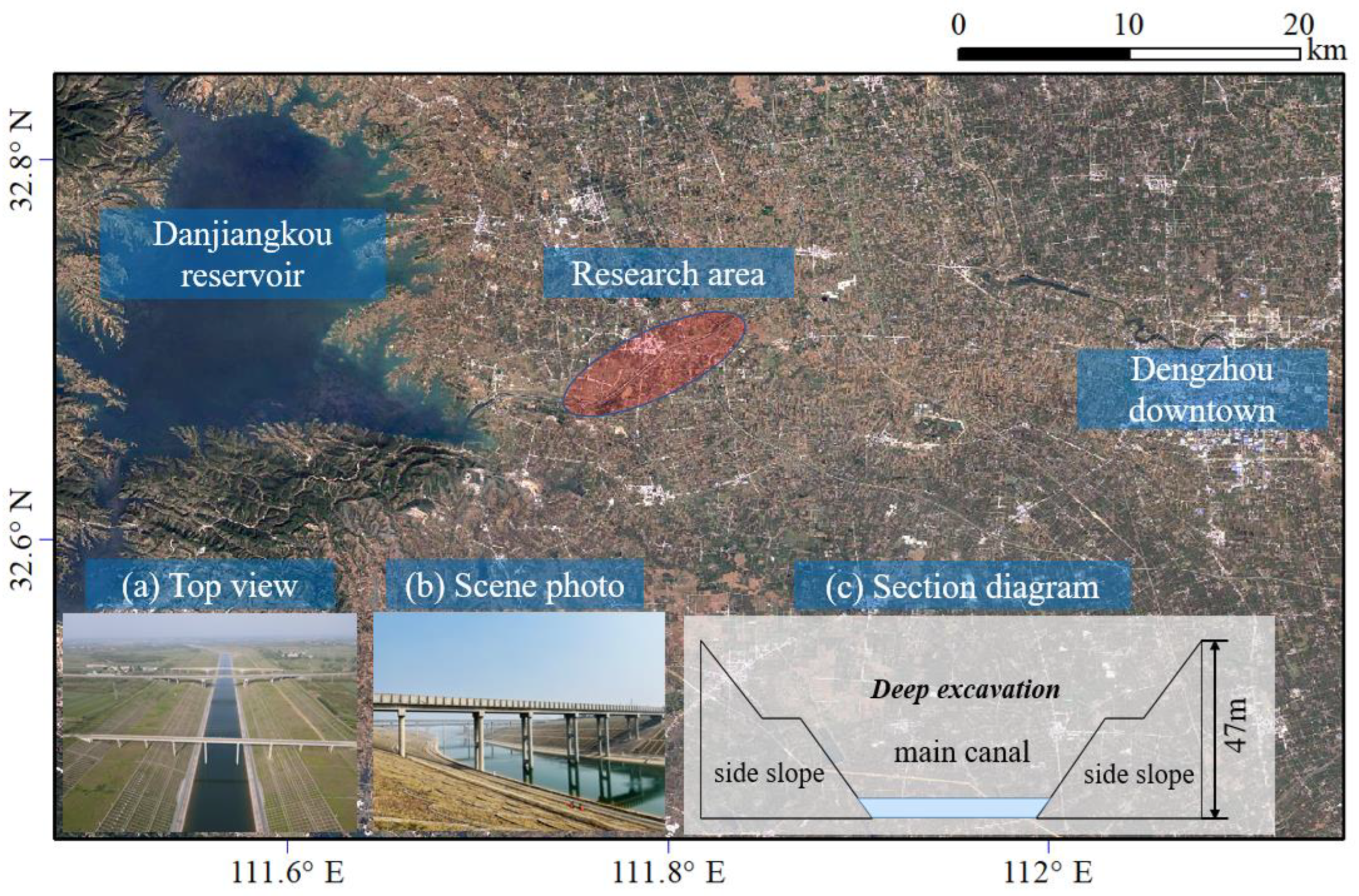
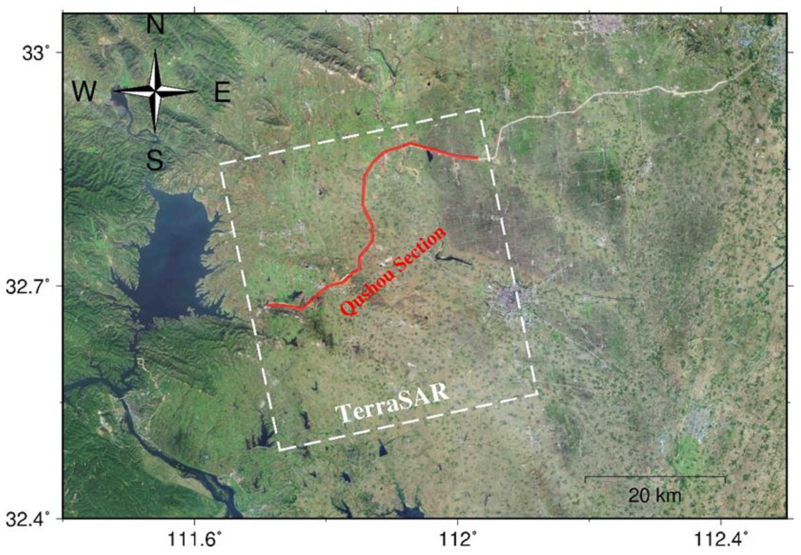
2.1. Introduction to the Study Area
2.2. Monitoring Data Preparation
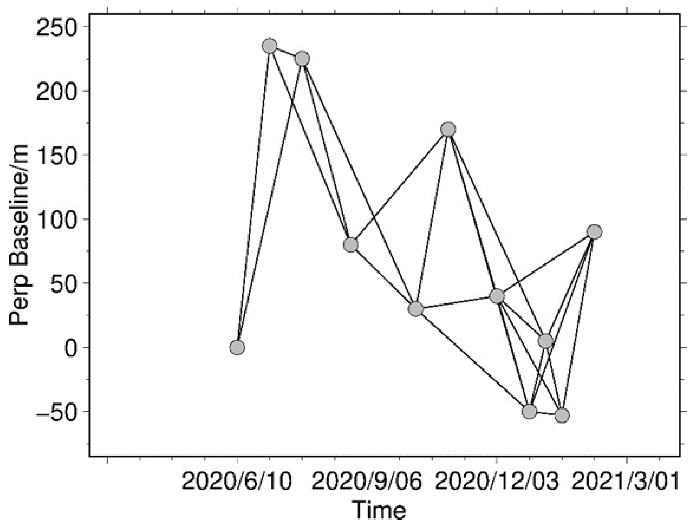
2.2.1. SAR Data
2.2.2. GNSS and Soil Moisture Data
2.3. Data Processing Method
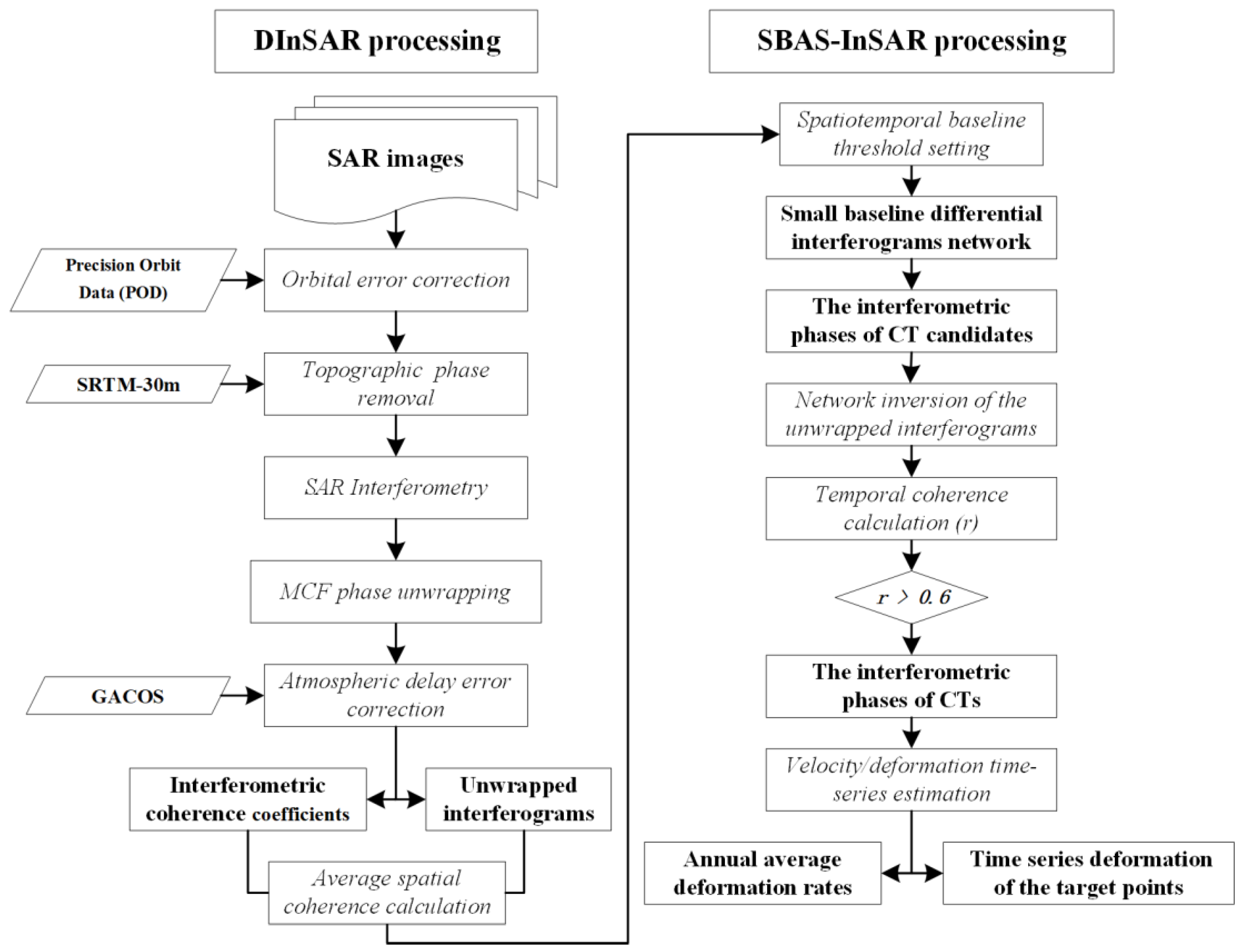
2.3.1. SAR Data Processing Method
2.3.2. GNSS Monitoring Technology
Function Model
Stochastic Model
Conversion of XYZ to NEU
3. Results
3.1. Deformation Law Analysis of the Deep Excavation Channel Slope Based on TerraSAR-X Data
3.2. Analysis of the Surface Deformation Mechanism of the Channel Slope
4. Discussion
4.1. Reliability Analysis of the Detection Results
4.2. Shortcomings and Future Research Plans
5. Conclusions
- (1)
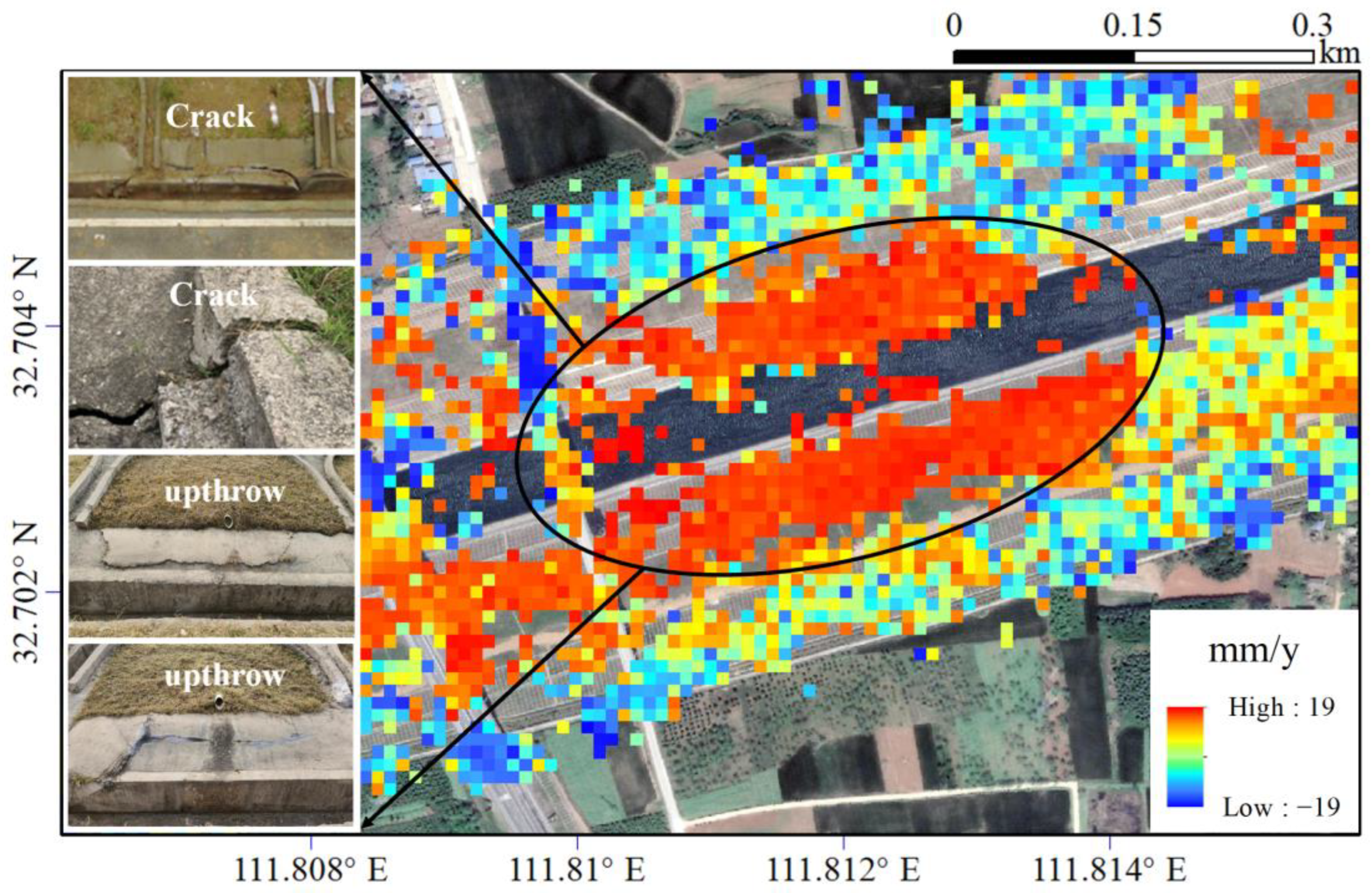
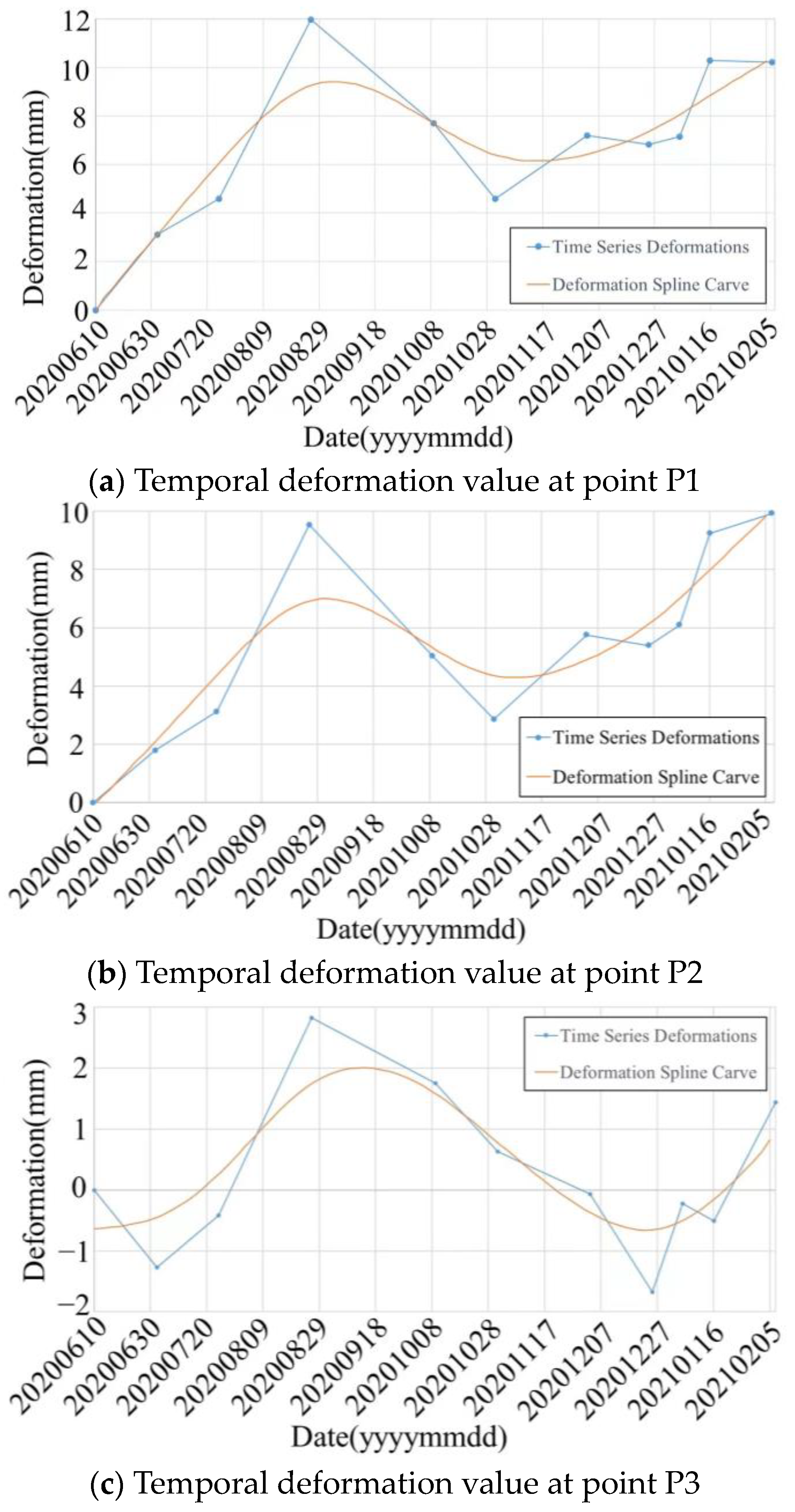
- Aiming at the limitations of current deformation monitoring means in the study area, the cooperative monitoring technology of SBAS-InSAR and GNSS was proposed. By employing SBAS-InSAR technology and high-resolution TerraSAR-X data, this study unveils the distribution and temporal sequence characteristics of deformations within the slope domain of the deep-dug expansive-soil channel section in the South–North Water-Diversion Middle-Route Project in China. The results exhibited two distinct deformation types: uplift and subsidence. Uplifted deformation was primarily concentrated downstream, while subsidence was predominantly observed in the middle and upstream regions of the section. The uplifted deformation areas surpassed the subsidence areas in both the extent and magnitude of occurrence, emphasizing their greater severity. Analysis of the temporal deformation characteristics at the measurement points within the deformation area revealed a cyclic pattern of “uplift→partial fallback→uplift again”. Moreover, horizontal displacement demonstrated a continuous accumulation trend, with larger displacements occurring toward the inner part of the channel;
- (2)
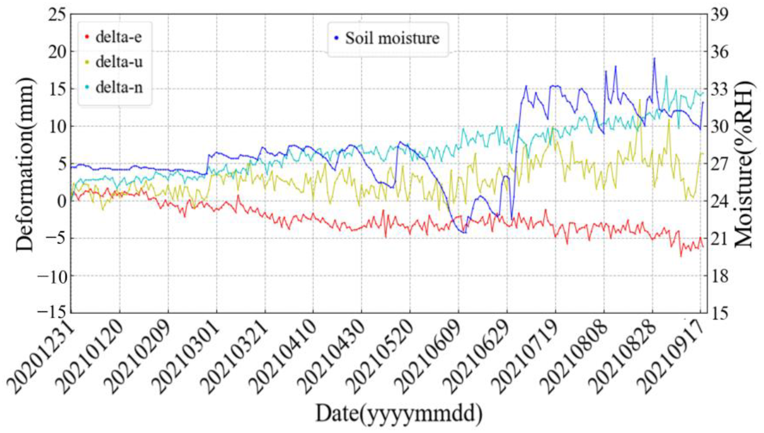
- Combined with the geological engineering conditions of the study area, the deformation mechanism of the channel slope was elucidated. The study pointed out that the primary cause of the uplift deformation was the expansion of expansive soil upon contact with water. Conversely, the slight settlement was attributed to the combined effects of static loads from buildings, dynamic loads from large trucks, and the expansion of expansive soil in contact with water. Through the analysis of the soil moisture content and GNSS measurements, it was concluded that soil humidity exerted significant influence on vertical displacement at the surface. A lower soil moisture content corresponds to smaller vertical displacement, whereas higher soil moisture content results in larger vertical displacement. Moreover, there exists a strong positive correlation between surface vertical displacement and soil moisture;
- (3)
- Based on the study results and field research, it was observed that the surface of the channel slopes within the severely uplifted deformation area suffered varying degrees of damage, which was estimated to be further aggravated during the subsequent evolution of the soil in many dry–wet alternations. To comprehensively elucidate the deformation pattern and mechanism of the channel, we advocate for an extended duration of surface deformation monitoring in this area. This will facilitate a thorough understanding of the deformation process and enable appropriate repair measures to be recommended to ensure the safe operation of the channel. Furthermore, the proposed SBAS-InSAR and GNSS collaborative monitoring technology provides a safety guarantee for the high-quality development of China’s South–North Water-Diversion Follow-up Project as well as an effective technical means for accurately carrying out the deformation monitoring of large-scale banded water-conservancy projects.
Author Contributions
Funding
Data Availability Statement
Conflicts of Interest
References
- Gupta, J.; van der Zaag, P. Interbasin Water Transfers and Integrated Water Resources Management: Where Engineering, Science and Politics Interlock. Phys. Chem. Earth Parts ABC 2008, 33, 28–40. [Google Scholar] [CrossRef]
- Wang, X.; He, X.; Xiao, R.; Song, M.; Jia, D. Millimeter to Centimeter Scale Precision Water-Level Monitoring Using GNSS Reflectometry: Application to the South-to-North Water Diversion Project, China. Remote Sens. Environ. 2021, 265, 112645. [Google Scholar] [CrossRef]
- Yang, Z.; Huang, X.; Fang, G.; Ye, J.; Lu, C. Benefit Evaluation of East Route Project of South to North Water Transfer Based on Trapezoid Cloud Model. Agric. Water Manag. 2021, 254, 106960. [Google Scholar] [CrossRef]
- Sheng, J.; Webber, M. Incentive Coordination for Transboundary Water Pollution Control: The Case of the Middle Route of China’s South-North Water Transfer Project. J. Hydrol. 2021, 598, 125705. [Google Scholar] [CrossRef]
- Dong, J.; Lai, S.; Wang, N.; Wang, Y.; Zhang, L.; Liao, M. Multi-Scale Deformation Monitoring with Sentinel-1 InSAR Analyses along the Middle Route of the South-North Water Diversion Project in China. Int. J. Appl. Earth Obs. Geoinf. 2021, 100, 102324. [Google Scholar] [CrossRef]
- Yerro, A.; Corominas, J.; Monells, D.; Mallorquí, J.J. Analysis of the Evolution of Ground Movements in a Low Densely Urban Area by Means of DInSAR Technique. Eng. Geol. 2014, 170, 52–65. [Google Scholar] [CrossRef]
- Milczarek, W. Application of PSInSAR for Assessment of Surface Deformations in Post_mining Area—Case Study of the Former Walbrzych Hard Coal Basin (SW Poland). Acta Geodyn. Geomater. 2017, 14, 185. [Google Scholar] [CrossRef] [Green Version]
- Zhao, C.; Lu, Z.; Zhang, Q.; de la Fuente, J. Large-Area Landslide Detection and Monitoring with ALOS/PALSAR Imagery Data over Northern California and Southern Oregon, USA. Remote Sens. Environ. 2012, 124, 348–359. [Google Scholar] [CrossRef]
- Motagh, M.; Shamshiri, R.; Haghshenas Haghighi, M.; Wetzel, H.-U.; Akbari, B.; Nahavandchi, H.; Roessner, S.; Arabi, S. Quantifying Groundwater Exploitation Induced Subsidence in the Rafsanjan Plain, Southeastern Iran, Using InSAR Time-Series and in Situ Measurements. Eng. Geol. 2017, 218, 134–151. [Google Scholar] [CrossRef]
- Cigna, F.; Bateson, L.B.; Jordan, C.J.; Dashwood, C. Simulating SAR Geometric Distortions and Predicting Persistent Scatterer Densities for ERS-1/2 and ENVISAT C-Band SAR and InSAR Applications: Nationwide Feasibility Assessment to Monitor the Landmass of Great Britain with SAR Imagery. Remote Sens. Environ. 2014, 152, 441–466. [Google Scholar] [CrossRef] [Green Version]
- Malinowska, A.A.; Witkowski, W.T.; Hejmanowski, R.; Chang, L.; van Leijen, F.J.; Hanssen, R.F. Sinkhole Occurrence Monitoring over Shallow Abandoned Coal Mines with Satellite-Based Persistent Scatterer Interferometry. Eng. Geol. 2019, 262, 105336. [Google Scholar] [CrossRef]
- Chaussard, E.; Havazli, E.; Fattahi, H.; Cabral-Cano, E.; Solano-Rojas, D. Over a century of sinking in mexico city: No hope for significant elevation and storage capacity recovery. J. Geophys. Res. Solid Earth 2021, 126, e2020JB020648. [Google Scholar] [CrossRef]
- Chaussard, E.; Wdowinski, S.; Cahral-Cano, E.; Amelung, F. Land subsidence in central Mexico detected by ALOS InSAR time-series. Remote Sens. Environ. 2014, 140, 94–106. [Google Scholar] [CrossRef]
- Fernández-Torres, E.A.; Cabral-Cano, E.; Novelo-Casanova, D.A.; Solano-Rojas, D.; Havazli, E.; Salazar-Tlaczani, L. Risk assessment of land subsidence and associated faulting in Mexico City using InSAR. Nat. Hazards 2022, 114, 3861. [Google Scholar] [CrossRef]
- Figueroa-Miranda, S.; Vargas, J.T.; Ramos-Leal, J.; Hernández-Madrigal, V.M.; Villaseñor-Reyes, C.I. Land subsidence by groundwater over-exploitation from aquifers in tectonic valleys of Central Mexico: A review. Eng. Geol. 2018, 246, 91–106. [Google Scholar] [CrossRef]
- Du, Z.; Ge, L.; Ng, A.H.; Zhu, Q.; Zhang, Q.; Kuang, J.; Dong, Y. Long-Term Subsidence in Mexico City from 2004 to 2018 revealed by Five SAR Sensors. Land Degrad. Dev. 2019, 30, 1785–1801. [Google Scholar] [CrossRef]
- Ya, K.; Zhong, L.; Chaoying, Z.; Wei, Q. Inferring slip-surface geometry and volume of creeping landslides based on InSAR: A case study in Jinsha River basin. Remote Sens. Environ. 2023, 294, 113620. [Google Scholar] [CrossRef]
- Chunhao, P.; Qiang, X.; Xiaochen, W.; Zhigang, L.; Wanlin, C.; Kuanyao, Z.; Dehao, X.; Jialiang, L. Refined mapping and kinematic trend assessment of potential landslides associated with large-scale land creation projects with multitemporal InSAR. Int. J. Appl. Earth Obs. Geoinf. 2023, 118, 103266. [Google Scholar] [CrossRef]
- Menghua, L.; Lu, Z.; Mengshi, Y.; Mingsheng, L. Complex surface displacements of the Nanyu landslide in Zhouqu, China revealed by multi-platform InSAR observations. Eng. Geol. 2023, 317, 107069. [Google Scholar] [CrossRef]
- Weiping, J.; Yan, C.; Qusen, C.; Hua, C.; Yuanjin, P.; Xuexi, L.; Tianjun, L. High precision deformation monitoring with integrated GNSS and ground range observations in harsh environment. Measurement 2022, 204, 112179. [Google Scholar] [CrossRef]
- Bao, S.; Yuanhao, H.; Li, W.; Qin, Z.; Xinrui, L.; Xuanyu, Q.; Guanwen, H.; Wei, Q. Real-time high-precision landslide displacement monitoring based on a GNSS CORS network. Measurement 2023, 217, 113056. [Google Scholar] [CrossRef]
- Pengxu, W.; Hui, L.; Guigen, N.; Zhixin, Y.; Jiaji, W.; Chuang, Q.; Bao, S. Performance evaluation of a real-time high-precision landslide displacement detection algorithm based on GNSS virtual reference station technology. Measurement 2022, 199, 111457. [Google Scholar] [CrossRef]
- Wang, C.; Guo, W.; Meng, Q.; Liu, Y.; Bi, F. Landslide Deformation Monitoring Method and Performance Analysis Based on GNSS Virtual Reference Station. Geomat. Inf. Sci. Wuhan Univ. 2022, 47, 990–996. [Google Scholar] [CrossRef]
- Huang, Z.; Sun, H.Y.; Dai, Y.M.; Hou, P.B.; Zhou, W.Z.; Bian, L.L. A study on the shear strength and dry-wet cracking behaviour of waste fibre-reinforced expansive soil. Case Stud. Constr. Mater. 2022, 16, e01142. [Google Scholar] [CrossRef]
- Werner, C.; Wegmller, U.; Strozzi, T.; Wiesmann, A. Gamma SAR and Interferometric Processing Software. In Proceedings of the ERS-ENVISAT Symposium, Gothenburg, Sweden, 6–20 October 2000. [Google Scholar]
- Wegnüller, U.; Werner, C.; Strozzi, T.; Wiesmann, A.; Santoro, M. Sentinel-1 Support in the GAMMA Software. Procedia Comput. Sci. 2016, 100, 1305–1312. [Google Scholar] [CrossRef] [Green Version]
- Farr, T.G.; Rosen, P.A.; Caro, E.; Crippen, R.; Duren, R.; Hensley, S.; Kobrick, M.; Paller, M.; Rodriguez, E.; Roth, L. The Shuttle Radar Topography Mission. Rev. Geophys. 2007, 45, 361. [Google Scholar] [CrossRef] [Green Version]
- Goldstein, R.M.; Werner, C.L. Radar Interferogram Filtering for Geophysical Applications. Geophys. Res. Lett. 1998, 25, 4035–4038. [Google Scholar] [CrossRef] [Green Version]
- Goldstein, R.M.; Zebker, H.A.; Werner, C.L. Satellite Radar Interferometry: Two-Dimensional Phase Unwrapping. Radio Sci. 1988, 23, 713–720. [Google Scholar] [CrossRef] [Green Version]
- Zhang, Y.A.; Hf, B.; Fa, A. Small Baseline InSAR Time Series Analysis: Unwrapping Error Correction and Noise Reduction—ScienceDirect. Comput. Geosci. 2019, 133, 104331. [Google Scholar] [CrossRef] [Green Version]
- Fattahi, H.; Amelung, F. DEM Error Correction in InSAR Time Series. IEEE Trans. Geosci. Remote Sens. 2013, 51, 4249–4259. [Google Scholar] [CrossRef]
- Fattahi, H.; Amelung, F. InSAR Observations of Strain Accumulation and Fault Creep along the Chaman Fault System, Pakistan and Afghanistan. Geophys. Res. Lett. 2016, 43, 8399–8406. [Google Scholar] [CrossRef] [Green Version]
- Molina, D.E.; Datcu, M.; Gleich, D.A. Assessment of Two Gibbs Random Field Based Feature Extraction Methods for SAR Images Using a Cramer-Rao Bound. In Proceedings of the European Conference on Synthetic Aperture Radar, Aachen, Germany, 7–10 June 2010. [Google Scholar]
- Li, X.; Zhang, W.; Yuan, Y.; Zhang, K.; Wu, J.; Lou, J.; Li, J.; Zheng, H. Review of GNSS Precise Orbit Determination: Status, Challenges, and Opportunities. Acta Geod. Cartogr. Sin. 2022, 51, 1271. [Google Scholar] [CrossRef]
- Leandro, R.F. Precise Point Positioning with GPS: A New Approach for Positioning, Atmospheric Studies, and Signal Analysis. Ph.D. Thesis, University of New Brunswick, Fredericton, NB, Canada, 2009. [Google Scholar]




| No. | Data | Track Number | Strip | Orbital Direction |
|---|---|---|---|---|
| 1 | 10 June 2020 | 51 | 009R | Ascending |
| 2 | 2 July 2020 | 51 | 009R | Ascending |
| 3 | 24 July 2020 | 51 | 009R | Ascending |
| 4 | 26 August 2020 | 51 | 009R | Ascending |
| 5 | 9 October 2020 | 51 | 009R | Ascending |
| 6 | 31 October 2020 | 51 | 009R | Ascending |
| 7 | 3 December 2020 | 51 | 009R | Ascending |
| 8 | 25 December 2020 | 51 | 009R | Ascending |
| 9 | 5 January 2021 | 51 | 009R | Ascending |
| 10 | 16 January 2021 | 51 | 009R | Ascending |
| 11 | 7 February 2021 | 51 | 009R | Ascending |
| Number | Date | Deformation Characteristic | Deformation Value (mm) |
|---|---|---|---|
| P1 | 10 June 2020–29 August 2020 | Uplift | 0→12 |
| 29 August 2020–28 October 2020 | Settlement | 12→4.3 | |
| 28 October 2020–5 February 2021 | Uplift | 4.3→10 | |
| P2 | 10 June 2020–29 August 2020 | Uplift | 0→9.8 |
| 29 August 2020–28 October 2020 | Settlement | 9.8→3 | |
| 28 October 2020–5 February 2021 | Uplift | 3→10 | |
| P3 | 10 June 2020–29 August 2020 | Uplift | 0→3 |
| 29 August 2020–27 December 2020 | Settlement | 3→−1.7 | |
| 27 December 2020–5 February 2021 | Uplift | −1.7→1.5 |
| Date | Level Measuring/mm | SBAS-InSAR/mm | Errors/mm | ||||||
|---|---|---|---|---|---|---|---|---|---|
| A1 | A2 | A3 | A1 | A2 | A3 | A1 | A2 | A3 | |
| 2 July 2020 | 3 | 4 | 4 | 4 | 5 | 5 | −1 | −1 | −1 |
| 24 July 2020 | 4 | 5 | 5 | 6 | 7 | 7 | −2 | −2 | −2 |
| 26 August 2020 | 12 | 13 | 13 | 14 | 15 | 15 | −2 | −2 | −2 |
| 9 October 2020 | 7 | 8 | 8 | 8 | 9 | 9 | −1 | −1 | −1 |
| 31 October 2020 | 4 | 5 | 5 | 5 | 6 | 6 | −1 | −1 | −1 |
| 3 December 2020 | 6 | 7 | 7 | 7 | 8 | 8 | −1 | −1 | −1 |
| 25 December 2020 | 5 | 6 | 7 | 6 | 8 | 8 | −1 | −2 | −1 |
| 5 January 2021 | 6 | 7 | 7 | 7 | 8 | 8 | −1 | −1 | −1 |
| 16 January 2021 | 10 | 11 | 11 | 11 | 12 | 12 | −1 | −1 | −1 |
| 7 February 2021 | 10 | 11 | 11 | 11 | 11 | 12 | −1 | 0 | −1 |
Disclaimer/Publisher’s Note: The statements, opinions and data contained in all publications are solely those of the individual author(s) and contributor(s) and not of MDPI and/or the editor(s). MDPI and/or the editor(s) disclaim responsibility for any injury to people or property resulting from any ideas, methods, instructions or products referred to in the content. |
© 2023 by the authors. Licensee MDPI, Basel, Switzerland. This article is an open access article distributed under the terms and conditions of the Creative Commons Attribution (CC BY) license (https://creativecommons.org/licenses/by/4.0/).
Share and Cite
Hu, Q.; Kou, Y.; Liu, J.; Liu, W.; Yang, J.; Li, S.; He, P.; Liu, X.; Ma, K.; Li, Y.; et al. TerraSAR-X and GNSS Data for Deformation Detection and Mechanism Analysis of a Deep Excavation Channel Section of the China South–North Water-Diversion Project. Remote Sens. 2023, 15, 3777. https://doi.org/10.3390/rs15153777
Hu Q, Kou Y, Liu J, Liu W, Yang J, Li S, He P, Liu X, Ma K, Li Y, et al. TerraSAR-X and GNSS Data for Deformation Detection and Mechanism Analysis of a Deep Excavation Channel Section of the China South–North Water-Diversion Project. Remote Sensing. 2023; 15(15):3777. https://doi.org/10.3390/rs15153777
Chicago/Turabian StyleHu, Qingfeng, Yingchao Kou, Jinping Liu, Wenkai Liu, Jiuyuan Yang, Shiming Li, Peipei He, Xianlin Liu, Kaifeng Ma, Yifan Li, and et al. 2023. "TerraSAR-X and GNSS Data for Deformation Detection and Mechanism Analysis of a Deep Excavation Channel Section of the China South–North Water-Diversion Project" Remote Sensing 15, no. 15: 3777. https://doi.org/10.3390/rs15153777
APA StyleHu, Q., Kou, Y., Liu, J., Liu, W., Yang, J., Li, S., He, P., Liu, X., Ma, K., Li, Y., Wang, P., Lu, W., & Hai, H. (2023). TerraSAR-X and GNSS Data for Deformation Detection and Mechanism Analysis of a Deep Excavation Channel Section of the China South–North Water-Diversion Project. Remote Sensing, 15(15), 3777. https://doi.org/10.3390/rs15153777


