Using InSAR and GPR Techniques to Detect Subsidence: Application to the Coastal Area of “A Xunqueira” (NW Spain)
Abstract
1. Introduction
Complementary InSAR and GPR Surveying
2. Materials and Methods
2.1. Description of the Case Study
2.2. Methodology
2.2.1. InSAR Data and Processing
PSI Processing
SBAS Processing
2.2.2. GPR Data Acquisition and Processing
3. Results
3.1. PSI Results
3.2. SBAS Results
3.3. PSI-SBAS Comparison and Additional GPR Analyses
4. Conclusions
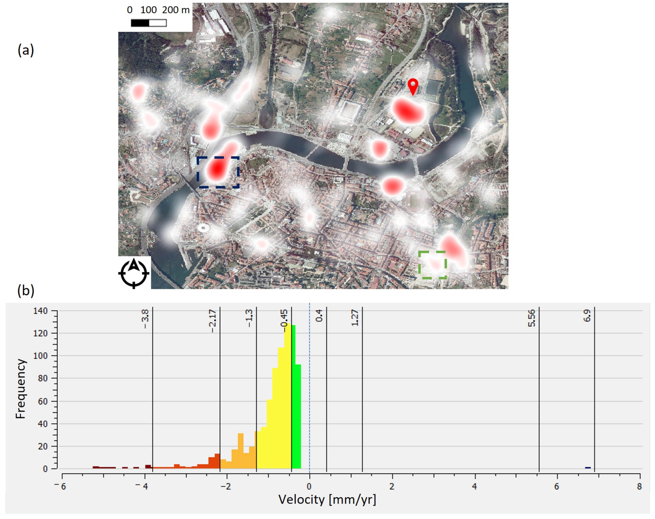
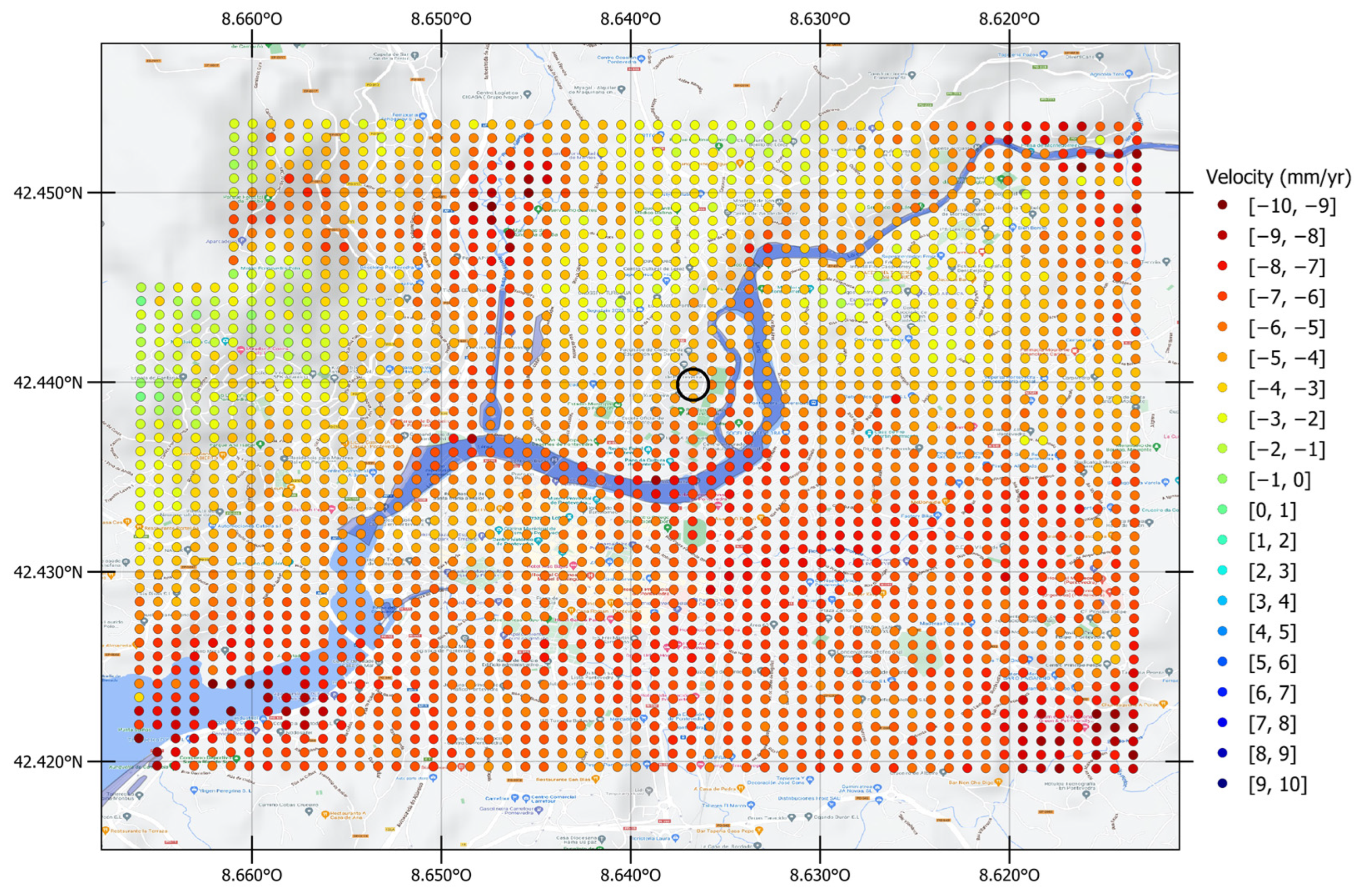
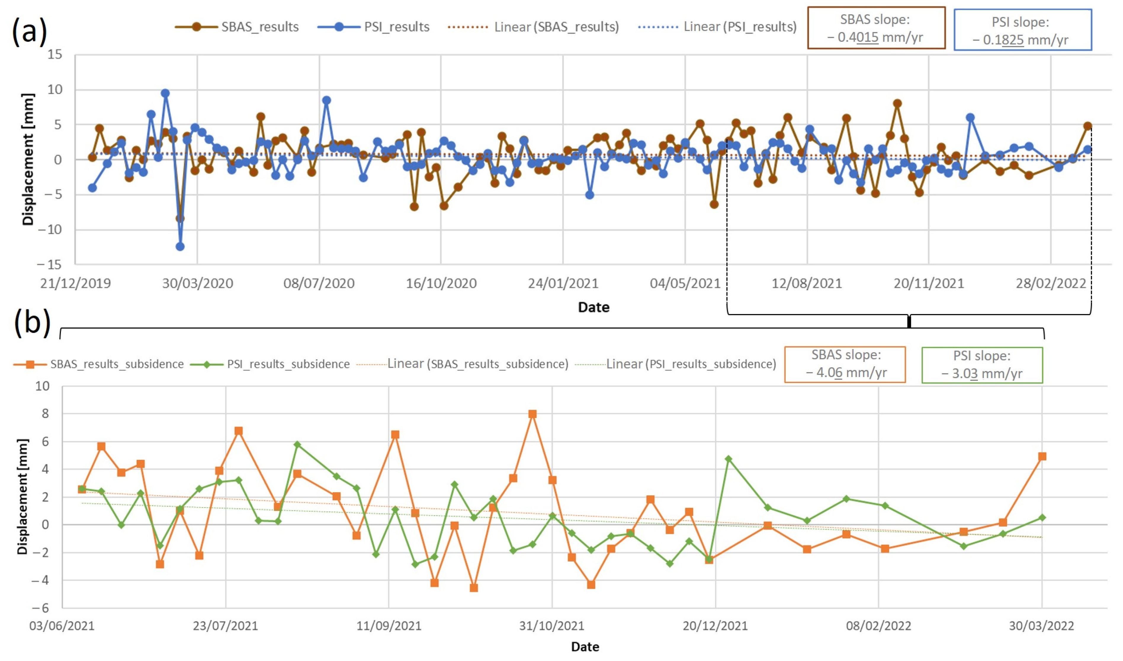
- For the period from January 2020 to March 2022, and for the global area of Pontevedra city, the average velocities obtained with the PSI and SBAS methods were −0.2 mm/yr and −0.4 mm/yr, respectively. In both cases, the area presents a massive dominance of negative values that mean a slight sinking effect.
- For the same period, the PSI results in the area of the Forestry Engineering School building have revealed scatters with different velocity trends, showing maximum and minimum deformation rates of 1.0 mm/yr and −0.8 mm/yr, respectively. However, a drawback of the PSI method was revealed, which refers to the fact that analyses with long temporal spectrums, such as 2 years in our case, motivate over-filtering. Observing the time series, 96.8% of the measurements were in a displacement range of 10 mm. To overcome this limitation, and taking into account the errors and orography of the zone, a temporal spectrum of one year (from June 2021 to March 2022) was additionally processed.
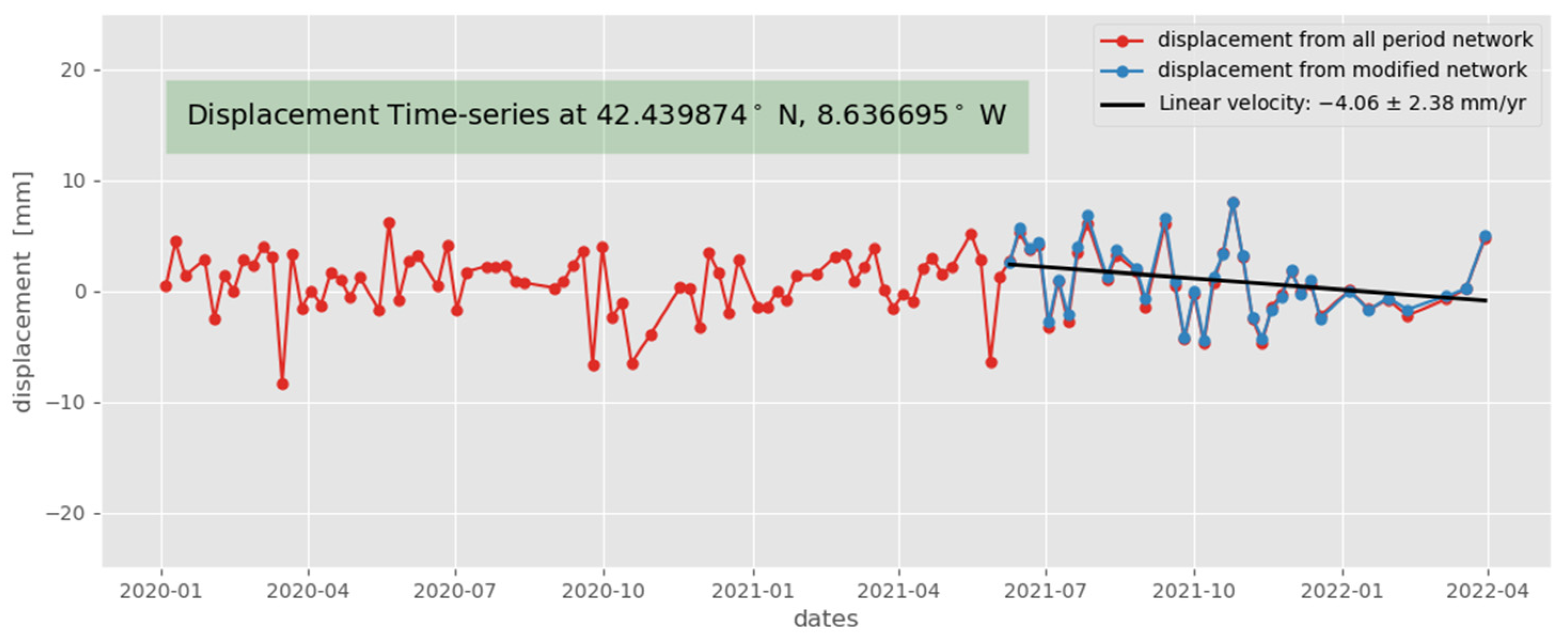
- Thus, for the period from June 2021 to March 2022, a higher pattern of subsidence was detected with values of −3.0 mm/yr and −4.1 mm/yr for PSI and SBAS, respectively. Instantaneous displacements of about ±1 cm at 12-day intervals have also been observed with the SBAS method. All the values are within the detection threshold considered for InSAR [74].
- Overall, the PSI and SBAS methods have shown a good match, with similar tendency and displacement range values. The fact that both methods display similar results, with similar initial data, reinforces the validation of the use of SAR techniques for infrastructure analyses focusing on subsidence.
- Although both InSAR techniques have provided similar results, it should be highlighted that the PSI method provides extra information (critical points, such as PSs with high subsidence rate).
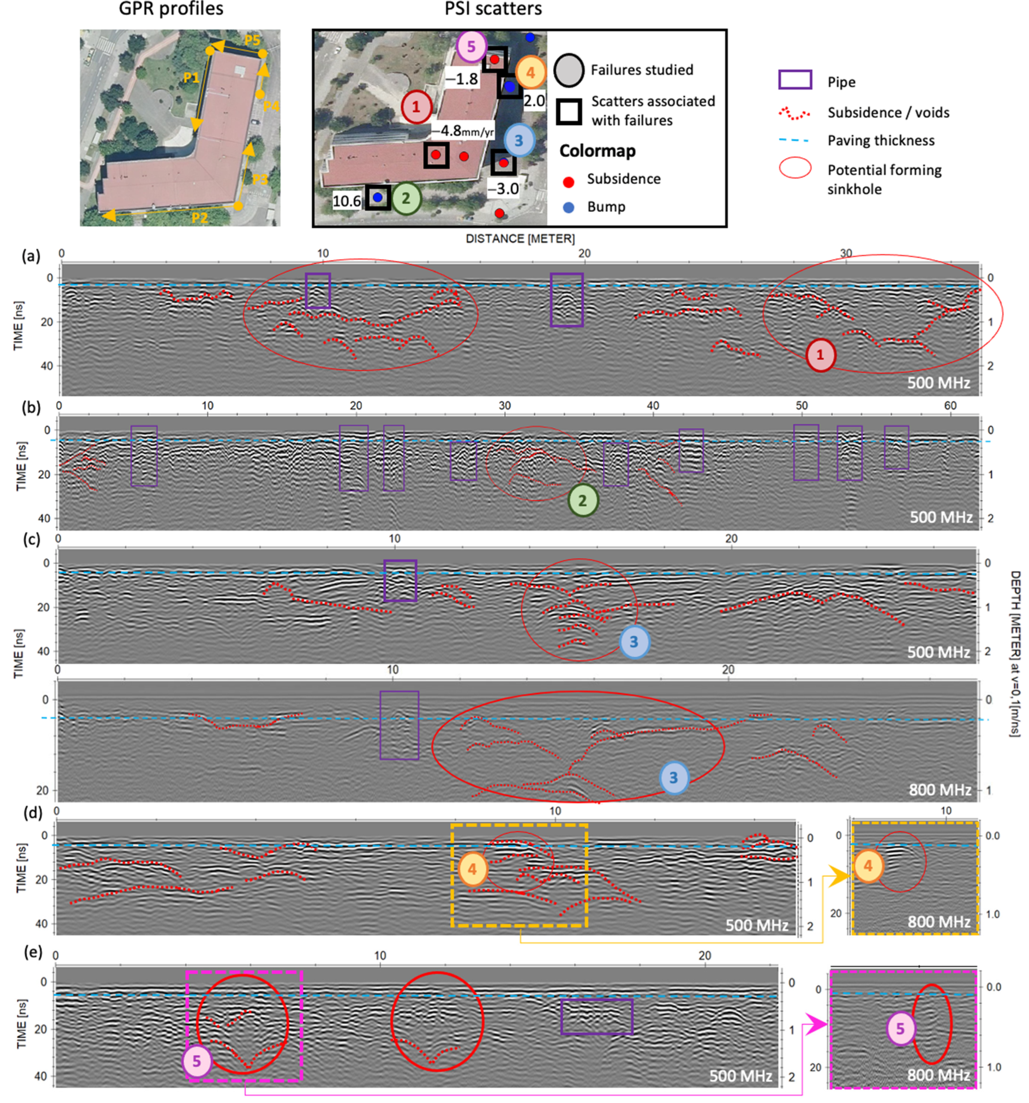
- Regarding the complementary GPR method used, the radar data collected in January 2022 allowed for the identification of internal failures around the Forestry Engineering School building. From the reflection patterns produced, it was possible to estimate the extent and depth (edges delineation) of the cavity’s formations.
- The internal damages interpreted from the GPR data showed a good agreement with the PS obtained for this area and with the visible damages identified from visual inspection (location and kind of failure (subsidence or elevation)), thus providing crucial information, and supporting more appropriate decision making and preventive maintenance.
Author Contributions
Funding
Data Availability Statement
Conflicts of Interest
References
- Galve, J.P.; Gutiérrez, F.; Guerrero, J.; Alonso, J.; Diego, I. Application of risk, cost–benefit and acceptability analyses to identify the most appropriate geosynthetic solution to mitigate sinkhole damage on roads. Eng. Geol. 2012, 145–146, 65–77. [Google Scholar]
- Pueyo-Anchuela, O.; Juan, A.P.; Soriano, M.A.; Casas-Sainz, A.M. Characterization of karst hazards from the perspective of the doline triangle using GPR—examples from Central Ebro Basin (Spain). Eng. Geol. 2009, 108, 225–236. [Google Scholar]
- Dobecki, T.L.; Upchurch, S.B. Geophysical applications to detect sinkholes and ground subsidence. Lead. Edge 2006, 25, 336. [Google Scholar] [CrossRef]
- SIRs DATA–Map Direct. Subsidence Incident Reports. Florida Department of Environmental Protection. Available online: https://ca.dep.state.fl.us/mapdirect/?focus=fgssinkholes (accessed on 16 March 2022).
- Aurit, M.D.; Peterson, R.O.; Blanford, J.I. A GIS Analysis of the Relationship between Sinkholes, Dry-Well Complaints and Groundwater Pumping for Frost-Freeze Protection of Winter Strawberry Production in Florida. PLoS ONE 2013, 8, e53832. [Google Scholar] [CrossRef]
- Meng, Y.; Long, J. Global warming causes sinkhole collapse—Case study in Florida, USA. Nat. Hazards Earth Syst. Sci. Discuss. 2018, 1–8. [Google Scholar] [CrossRef]
- Cuthbert, M.O.; Gleeson, T.; Moosdorf, N.; Befus, K.M.; Schneider, A.; Hartmann, J.; Lehner, B. Global patterns and dynamics of climate–groundwater interactions. Nat. Clim. Chang. 2019, 9, 137–141. [Google Scholar] [CrossRef]
- González, P.; Lamur, A.; Lavallée, Y. Squeezing porous basaltic rocks: Understanding compaction of basaltic aquifers due to groundwater extraction at Tenerife Island. Geophys. Res. Abstr. 2018, 20, 18585. [Google Scholar]
- Mimura, N. Rising seas and subsiding cities. Nat. Clim. Chang. 2021, 11, 296–297. [Google Scholar] [CrossRef]
- Dávila, F.M.; Ávila, P.; Martina, F. Relative contributions of tectonics and dynamic topography to the Mesozoic-Cenozoic subsidence of southern Patagonia. J. S. Am. Earth Sci. 2019, 93, 412–423. [Google Scholar] [CrossRef]
- Varbla, S.; Ellmann, A.; Puust, R. Centimetre-range deformations of built environment revealed by drone-based photogrammetry. Autom. Constr. 2021, 128, 103787. [Google Scholar] [CrossRef]
- Argyrakis, P.; Ganas, A.; Valkaniotis, S.; Tsioumas, V.; Sagias, N.; Psiloglou, B. Anthropogenically induced subsidence in Thessaly, central Greece: New evidence from GNSS data. Nat. Hazards 2020, 102, 179–200. [Google Scholar] [CrossRef]
- Tao, T.; Liu, J.; Qu, X.; Gao, F. Real-time monitoring rapid ground subsidence using GNSS and Vondrak filter. Acta Geophys. 2019, 67, 133–140. [Google Scholar] [CrossRef]
- Kiani, M. A precise machine learning aided algorithm for land subsidence or upheave prediction from GNSS time series. arXiv 2020, arXiv:2006.03772. [Google Scholar]
- Rahmati, O.; Falah, F.; Naghibi, S.A.; Biggs, T.; Soltani, M.; Deo, R.C.; Cerdà, A.; Mohammadi, F.; Bui, D.T. Land subsidence modelling using tree-based machine learning algorithms. Sci. Total Environ. 2019, 672, 239–252. [Google Scholar] [CrossRef]
- Saganeiti, L.; Amato, F.; Nolè, G.; Vona, M.; Murgante, B. Early estimation of ground displacements and building damage after seismic events using SAR and LiDAR data: The case of the Amatrice earthquake in central Italy, on 24th August 2016. Int. J. Disaster Risk Reduct. 2020, 51, 101924. [Google Scholar] [CrossRef]
- Ramirez, R.A.; Lee, G.J.; Choi, S.K.; Kwon, T.H.; Kim, Y.C.; Ryu, H.H.; Kim, S.; Bae, B.; Hyun, C. Monitoring of construction-induced urban ground deformations using Sentinel-1 PS-InSAR: The case study of tunneling in Dangjin, Korea. Int. J. Appl. Earth Obs. Geoinf. 2022, 108, 102721. [Google Scholar]
- Wu, P.C.; Wei, M.; D’hondt, S. Subsidence in Coastal Cities Throughout the World Observed by InSAR. Geophys. Res. Lett. 2022, 49, e2022GL098477. [Google Scholar] [CrossRef]
- Park, S.W.; Hong, S.W. Nonlinear Modeling of Subsidence From a Decade of InSAR Time Series. Geophys. Res. Lett. 2021, 48, 3. [Google Scholar] [CrossRef]
- Tosti, F.; Gagliardi, V.; D’amico, F.; Alani, A.M. Transport infrastructure monitoring by data fusion of GPR and SAR imagery information. Transp. Res. Procedia 2020, 45, 771–778. [Google Scholar] [CrossRef]
- Hu, L.; Dai, K.; Xing, C.; Li, Z.; Tomás, R.; Clark, B.; Shi, X.; Chen, M.; Zhang, R.; Qiu, Q.; et al. Land subsidence in Beijing and its relationship with geological faults revealed by Sentinel-1 InSAR observations. Int. J. Appl. Earth Obs. Geoinf. 2019, 82, 101886. [Google Scholar] [CrossRef]
- Hu, B.; Chen, J.; Zhang, X. Monitoring the Land Subsidence Area in a Coastal Urban Area with InSAR and GNSS. Sensors 2019, 19, 3181. [Google Scholar] [CrossRef] [PubMed]
- Farolfi, G.; Del Soldato, M.; Bianchini, S.; Casagli, N. A procedure to use GNSS data to calibrate satellite PSI data for the study of subsidence: An example from the north-western Adriatic coast (Italy). Eur. J. Remote Sens. 2019, 52, 54–63. [Google Scholar] [CrossRef]
- Cigna, F.; Esquivel Ramírez, R.; Tapete, D. Accuracy of Sentinel-1 PSI and SBAS InSAR Displacement Velocities against GNSS and Geodetic Leveling Monitoring Data. Remote Sens. 2021, 13, 4800. [Google Scholar] [CrossRef]
- He, Z.; Chen, T.; Wang, M.; Li, Y. Multi-Segment Rupture Model of the 2016 Kumamoto Earthquake Revealed by InSAR and GPS Data. Remote Sens. 2020, 12, 3721. [Google Scholar] [CrossRef]
- Carboni, F.; Porreca, M.; Valerio, E.; Mariarosaria, M.; De Luca, C.; Azzaro, S.; Ercoli, E.; Barchi, M.R. Surface ruptures and off-fault deformation of the October 2016 central Italy earthquakes from DInSAR data. Sci. Rep. 2022, 12, 3172. [Google Scholar] [CrossRef] [PubMed]
- Lazos, I.; Papanikolaou, I.; Sboras, S.; Foumelis, M.; Pikridas, C. Geodetic Upper Crust Deformation Based on Primary GNSS and INSAR Data in the Strymon Basin, Northern Greece—Correlation with Active Faults. Appl. Sci. 2022, 12, 9391. [Google Scholar] [CrossRef]
- Yalvac, S. Validating InSAR-SBAS results by means of different GNSS analysis techniques in medium- and high-grade deformation areas. Environ. Monit. Assess. 2020, 192, 120. [Google Scholar] [CrossRef]
- Rauff, K.O.; Abir, I.A. Monitoring of the ground deformation in Penang Island, Malaysia using Permanent Scatterer Interferometry Synthetic Aperture Radar (PS-InSAR) and Ground-Penetrating Radar (GPR) techniques. Acta Geodyn. Geomater. 2021, 18, 461–472. [Google Scholar]
- Busetti, A.; Calligaris, C.; Forte, E.; Areggi, G.; Mocnik, A.; Zini, L. Non-Invasive Methodological Approach to Detect and Characterize High-Risk Sinkholes in Urban Cover Evaporite Karst: Integrated Reflection Seismics, PS-InSAR, Leveling, 3D-GPR and Ancillary Data. A NE Italian Case Study. Remote Sens. 2020, 12, 3814. [Google Scholar] [CrossRef]
- Talib, O.-C.; Shimon, W.; Sarah, K.; Tonian, R. Detection of sinkhole activity in West-Central Florida using InSAR time series observations. Remote Sens. Environ. 2022, 269, 112793. [Google Scholar] [CrossRef]
- Robinson, T.; Rodgers, B.; Oliver-Cabrera, T.; Downs, C.; Kruse, S.; Wdowinski, S.; Zhang, B.; Jazayeri, S.; Kiflu, H. Complex relationships between surface topography, ground motion, and cover sediments in covered karst, west-central Florida, USA. Geomorphology 2021, 392, 107927. [Google Scholar] [CrossRef]
- Hubatka, F.; Pospíšil, L.; Lazecký, M. Identification of ground instability in the housing estate complex based on georadar and satellite radar interferometry. Acta Geodyn. Geomater. 2021, 18, 231–240. [Google Scholar] [CrossRef]
- Martel, R.; Castellazzi, P.; Gloaguen, E.; Trépanier, L.; Garfias, J. ERT, GPR, InSAR, and tracer tests to characterize karst aquifer systems under urban areas: The case of Quebec City. Geomorphology 2018, 310, 45–56. [Google Scholar] [CrossRef]
- Carbonel, D.; Rodríguez-Tribaldos, V.; Gutiérrez, F.; Galve, J.P.; Guerrero, J.; Zarroca, M.; Roqué, C.; Linares, R.; McCalpin, J.P.; Acosta, E. Investigating a damaging buried sinkhole cluster in an urban area (Zaragoza city, NE Spain) integrating multiple techniques: Geomorphological surveys, DInSAR, DEMs, GPR, ERT, and trenching. Geomorphology 2015, 229, 3–16. [Google Scholar] [CrossRef]
- Gutiérrez, F.; Galve, J.P.; Lucha, P.; Castañeda, C.; Bonachea, J.; Guerrero, J. Integrating geomorphological mapping, trenching, InSAR and GPR for the identification and characterization of sinkholes: A review and application in the mantled evaporite karst of the Ebro Valley (NE Spain). Geomorphology 2011, 134, 144–156. [Google Scholar] [CrossRef]
- Cabral-Cano, E.; Arciniega-Ceballos, A.; Diaz-Molina, O.; Cigna, F.; Avila-Olivera, A.; Osmanoglu, B.; Dixon, T.H.; Demets, C.; Garduño-Monroy, V.H.; Vergara-Huerta, F.; et al. Is there a tectonic component to the subsidence process in Morelia, Mexico? IAHS-AISH Publ. 2010, 339, 164–169. [Google Scholar]
- La Voz de Galicia. Comienza la Urbanización de los Terrenos del Campus Universitario de A Xunqueira. Available online: https://www.lavozdegalicia.es/noticia/pontevedra/2017/07/27/comienza-urbanizacion-terrenos-campus-universitario/0003_201707P27C7994.htm (accessed on 12 April 2022).
- IberPix. Instituto Geográfico Nacional. Available online: http://www.ign.es/iberpix2/visor/?id=08_09_0315C2_F07_090811PAN (accessed on 10 March 2022).
- IGME (Instituto Geológico y Minero de España). Mapa Geológico de España a Escala 1:200.000 de Pontevedra La Guardia Hoja 16–26 1985, 1st ed.; Servicio de Publicaciones Ministerio de Industria y Energía: Madrid, Spain, 1985. [Google Scholar]
- Información Xeográfica de Galicia. Available online: http://mapas.xunta.gal/centro-de-descargas/ (accessed on 20 June 2022).
- Kulp, S.A.; Strauss, B.H. New elevation data triple estimates of global vulnerability to sea-level rise and coastal flooding. Nat. Commun. 2019, 10, 4844. [Google Scholar] [CrossRef]
- Diario de Pontevedra ¿Cómo Será Pontevedra en 30 Años Debido al Efecto del Cambio Climático? Available online: https://www.diariodepontevedra.es/articulo/pontevedra/como-quedara-pontevedra-30-anos/ (accessed on 14 March 2022).
- Rosen, P.A.; Hensley, S.; Joughin, I.R.; Li, F.K.; Madsen, S.N.; Rodriguez, E.; Goldstein, R.M. Synthetic aperture radar interferometry. Proc. IEEE 2000, 88, 333–382. [Google Scholar] [CrossRef]
- Gabriel, A.K.; Goldstein, R.M.; Zebker, H.A. Mapping small elevation changes over large areas: Differential radar interferometry. J. Geophys. Res. Solid Earth 1989, 94, 9183–9191. [Google Scholar] [CrossRef]
- Hooper, A.; Bekaert, D.; Spaans, K.; Arıkan, M. Recent advances in SAR interferometry time series analysis for measuring crustal deformation. Tectonophysics 2012, 514, 1–13. [Google Scholar] [CrossRef]
- Li, S.; Xu, W.; Li, Z. Review of the SBAS InSAR Time-series algorithms, applications, and challenges. J. Geodesy Geodyn. 2021, 13, 114–126. [Google Scholar] [CrossRef]
- Xue, F.; Lv, X.; Dou, F.; Yun, Y. A Review of Time-Series Interferometric SAR Techniques: A Tutorial for Surface Deformation Analysis. IEEE Geosci. Remote Sens. Mag. 2020, 8, 22–42. [Google Scholar] [CrossRef]
- Pepe, A.; Calò, F. A Review of Interferometric Synthetic Aperture RADAR (InSAR) Multi-Track Approaches for the Retrieval of Earth’s Surface Displacements. Appl. Sci. 2017, 7, 1264. [Google Scholar] [CrossRef]
- Ullo, S.L.; Addabbo, P.; Di Martire, D.; Sica, S.; Fiscante, N.; Cicala, L.; Angelino, C.V. Application of DInSAR Technique to High Coherence Sentinel-1 Images for Dam Monitoring and Result Validation Through In Situ Measurements. IEEE J. Sel. Top. Appl. Earth Obs. Remote Sens. 2019, 12, 875–890. [Google Scholar] [CrossRef]
- Ferretti, A.; Prati, C.; Rocca, F. Permanent scatterers in SAR interferometry. IEEE Trans. Geosci. Remote Sens. 2001, 39, 8–20. [Google Scholar] [CrossRef]
- Berardino, P.; Fornaro, G.; Lanari, R.; Sansosti, E. A new algorithm for surface deformation monitoring based on small baseline differential SAR interferograms. IEEE Trans. Geosci. Remote Sens. 2002, 40, 2375–2383. [Google Scholar] [CrossRef]
- Li, Z.; Cao, Y.; Wei, J.; Duan, M.; Wu, L.; Hou, J.; Zhu, J. Time-series InSAR ground deformation monitoring: Atmospheric delay modeling and estimating. Earth-Sci. Rev. 2019, 192, 258–284. [Google Scholar] [CrossRef]
- Guo, J.; Zhou, L.; Yao, C.; Hu, J. Surface Subsidence Analysis by Multi-Temporal InSAR and GRACE: A Case Study in Beijing. Sensors 2016, 16, 1495. [Google Scholar] [CrossRef]
- Yunjun, Z.; Fattahi, H.; Amelung, F. Small baseline InSAR time series analysis: Unwrapping error correction and noise reduction. Comput. Geosci. 2019, 133, 104331. [Google Scholar] [CrossRef]
- Fotiou, K.; Kakoullis, D.; Pekri, M.; Melillos, G.; Brcic, R.; Eineder, M.; Hadjimitsis, D.G.; Danezis, C. Space-Based Displacement Monitoring of Coastal Urban Areas: The Case of Limassol’s Coastal Front. Remote Sens. 2022, 14, 914. [Google Scholar] [CrossRef]
- ESA (European Space Agency). SNAP Sentinel Application Platform. Available online: https://step.esa.int/main/toolboxes/snap/ (accessed on 18 March 2022).
- Hooper, A.; Bekaert, D.; Hussain, E.; Spaans, K. StaMPS/MTI Manual. School of Earth and Environment University of Leeds. 2018. Version 4.1b. Available online: https://github.com/dbekaert/StaMPS/blob/master/Manual/StaMPS_Manual.pdf (accessed on 24 March 2022).
- Bovenga, F.; Wasowski, J.; Nitti, D.O.; Nutricato, R.; Chiaradia, M.T. Using COSMO/SkyMed X-band and ENVISAT C-band SAR interferometry for landslides analysis. Remote Sens. Environ. 2012, 119, 272–285. [Google Scholar] [CrossRef]
- Serco Italia SPA; StaMPS: Persistent Scatterer Interferometry Processing—Mexico City 2021 (Version 1.1). 2020. Available online: https://rus-copernicus.eu/portal/wp-content/uploads/library/education/training/HAZA12_StaMPsPSI_Processing_Tutorial.pdf (accessed on 11 May 2022).
- Hogenson, K.; Kristenson, H.; Kennedy, J.; Johnston, A.; Rine, J.; Logan, T.; Zhu, J.; Williams, F.; Herrmann, J.; Smale, J.; et al. Hybrid Pluggable Processing Pipeline (HyP3): A Cloud-Native Infrastructure for Generic Processing of SAR Data [Computer Software]. 2020. Available online: https://zenodo.org/record/8011588 (accessed on 20 May 2022).
- Annan, P. GPR: Principles, Procedures & Applications; Sensors and Software Inc.: Mississauga, ON, Canada, 2003; p. 278. [Google Scholar]
- Solla, M.; Pérez-Gracia, V.; Fontul, S. A Review of GPR Application on Transport Infrastructures: Troubleshooting and Best Practices. Remote Sens. 2021, 13, 672. [Google Scholar] [CrossRef]
- Solla, M.; Fernández, N. GPR analysis to detect subsidence: A case study on a loaded reinforced concrete pavement. Int. J. Pavement Eng. 2022, 1–15. [Google Scholar] [CrossRef]
- Lorenzo, H.; Cuéllar, V.; Hernández, M.T. Close range radar remote sensing of concrete degradation in a textile factory floor. J. Appl. Geophys. 2020, 47, 327–336. [Google Scholar] [CrossRef]
- Tallini, M.; Giamberardino, A.; Ranalli, D.; Scozzafava, M. GPR survey for investigation in building foundations. In Proceedings of the Tenth International Conference on Grounds Penetrating Radar, Delft, The Netherland, 21–24 June 2004. [Google Scholar]
- Pérez-Gracia, V.; García García, F.; Rodriguez Abad, I. GPR evaluation of the damage found in the reinforced concrete base of a block of flats: A case study. NDT E Int. 2008, 41, 341–353. [Google Scholar] [CrossRef]
- Pérez-Gracia, V.; Solla, M. Inspection Procedures for Effective GPR Surveying of Buildings; Benedetto, A., Pajewski, L., Eds.; Civil Engineering Applications of Ground Penetrating Radar; Springer Transactions in Civil and Environmental Engineering; Springer: Cham, Swizterland, 2015; pp. 97–123. [Google Scholar]
- Hong, W.-T.; Kang, S.; Lee, S.J.; Lee, J.-S. Analyses of GPR signals for characterization of ground conditions in urban areas. J. Appl. Geophys. 2018, 152, 65–76. [Google Scholar] [CrossRef]
- Capozzoli, L.; De Martino, G.; Polemio, M.; Rizzo, E. Geophysical Techniques for Monitoring Settlement Phenomena Occurring in Reinforced Concrete Buildings. Surv. Geophys. 2020, 41, 575–604. [Google Scholar] [CrossRef]
- Sevil, J.; Gutiérrez, F.; Carnicer, C.; Carbonel, D.; Desir, G.; García-Arnay, Á.; Guerrero, J. Characterizing and monitoring a high-risk sinkhole in an urban area underlain by salt through non-invasive methods: Detailed mapping, high-precision leveling and GPR. Eng. Geol. 2020, 272, 105641. [Google Scholar] [CrossRef]
- Miccinesi, L.; Beni, A.; Monchetti, S.; Betti, M.; Borri, C.; Pieraccini, M. Ground Penetrating Radar Survey of the Floor of the Accademia Gallery (Florence, Italy). Remote Sens. 2021, 13, 1273. [Google Scholar] [CrossRef]
- Solla, M.; López-Leira, J.M.; Alonso-Díaz, A.; Rodríguez, J.L. Ground-penetrating Radar and Geotechnical Analyses to Investigate the Foundation Settlements of an Indiana House in NW Spain. Int. J. Arch. Heritage 2022. [Google Scholar] [CrossRef]
- Havazli, E.; Wdowinski, S. Detection Threshold Estimates for InSAR Time Series: A Simulation of Tropospheric Delay Approach. Sensors 2021, 21, 1124. [Google Scholar] [CrossRef] [PubMed]







| Ref. | InSAR Findings | GPR Findings | Advantages of the Combination | Limitations |
|---|---|---|---|---|
| [29] | (PSI tech.): deformation values from −2.76 to −4.77 mm/yr | (300/800 MHz): subsurface anomalies and shallow depression (cavities, drains and road fractures) | The subsidence identified with the PSI technique is associated in the GPR data with subsurface faults (fractures, cavities, etc.), thus providing extra information | Not reported |
| [30] | (PSI tech.): average velocity in both orbit tracks; vertical velocity component (from −6 to 2 mm/yr) | (400 MHz): maps the shallow subsurface morphology showing depocenters | Both techniques are complementary: InSAR maps the surface movements of wide areas and GPR analyzes the subsurface | Limitation in the penetration depth of GPR. Some variables (vegetation, orbits…) and assumptions (the north component sensitivity, equal incidence angle, etc.) with InSAR can reduce the accuracy |
| [31] | (PSI tech.): several areas of localized subsidence (from −3 to −6 mm/yr) | (250 MHz): presence of sinkhole activity | GPR was used as ground-truthing: subsidence locations (InSAR) were associated with sinkhole presence (GPR) | The InSAR detection is limited to sinkholes that present subsidence for at least a longer period than the repeat pass interval of the satellite, also constrained by the relationship between spatial resolution and observed feature size |
| [32] | (PSI tech.): 1 mm/yr subsidence rate on the flank of the topography is low but stable in its center | (250 MHz): ongoing conical subsidence and sediments raveling into underlying voids | The use of both techniques allows for optimizing the detection and delineation of sinkhole structures | Resolving subsidence rates is more difficult in grassy than in arid settings. InSAR interpretation was limited by spatial coverage. Using lower frequency GPR antennas will resolve the deeper structure |
| [33] | (PSI tech.): vertical displacement from different orbit tracks (up to −9 mm/yr) | (100 MHz): weakened sites, subsoil failures at the level of the bearing layer, tectonic activity | The joint use is very effective at identifying displacement tendencies in urbanized areas. (More reliable results, failures sized and detect tendencies) | Not reported |
| [34] | (PSI tech.): karst stability and backtrack historical ground movements | (100 MHz): anomalies associated with voids (groundwater flow within the karst system) | A better understanding of a karstic flow system in urban areas | PSI limitations: convert phase shifts into distance for sudden and nonlinear movements and discriminates between terrain movement and target instability GPR urban infrastructures make it difficult for data collection and interpretation |
| [35] | (PSI tech.): progressive subsidence | (180 MHz): information from the shallow subsurface | Both techniques complement each other and detect new faults | Conductive materials and gardened areas limit the GPR depth investigation |
| [36] | (PSI tech.?): rate values ranging from 4.4 to 17.3 mm/yr | (600/200 MHz): shallow cavities, depth of the rockhead and water table, sinkholes and edges definition | To determine or corroborate the active nature of some of the sinkholes and, in some cases, improve the location of the sinkhole edges | The loss of coherence, mainly related to the presence of agricultural fields and vegetation, reduce the density of measurement points |
| [37] | (PSI tech.): the highest subsiding area resulted in −50 mm/yr | (200 MHz & 40/70 MHz): faults and probable origin | The subsiding area identified with the PSI technique is supported by the fault detected by the GPR | Not reported |
| Technique | SBAS | PSI |
|---|---|---|
| Satellite mission | Sentinel-1A/1B | |
| Geometry | Descending | |
| Frequency band | C (5.6 cm) | |
| Revisit period | 6 days | |
| Incidence angle (Forestry Engineering School building) | 37.6° | |
| Path | 125 (frames: 448, 450) | |
| Time coverage | January 2020 to March 2022; 821 days | |
| Number of scenes | 126 | 125 |
| Master image | Not applicable | 1 October 2021 |
| Initial State | Stamps (Third Step) | Stamps (Fourth Step) | |
|---|---|---|---|
| 10,989 stable-phase pixels | 10,921 PS selected | 1684 PS kept after dropping adjacent pixels | 1650 PS after dropping noisy pixels |
| Filters | Setting | |
|---|---|---|
| 500 MHz | 800 MHz | |
| Subtract-mean (dewow) | Time window: 2 ns | Time window: 1.25 ns |
| Gain function | Linear: 1.44 and Exponential: 1.44 | Linear: 2 and Exponential: 2 |
| Background removal | by default (total time window) | |
| Bandpass (Butterworth) | Lower: 305 MHz Upper: 773 MHz | Lower: 522 MHz Upper: 1563 MHz |
| Migration (Kirchhoff) | Velocity (hyperbola fitting): 0.1 m/ns | |
| SBAS|PSI | ||||
|---|---|---|---|---|
| Temperature [°C] | Humidity [%] | Precipitation [mL] | ||
| Spearman coefficient | Correlation | 0.19|0.24 | 0.09|−0.21 | 0.14|−0.16 |
| p value | 0.047|0.011 | 0.340|0.029 | 0.140|0.090 | |
Disclaimer/Publisher’s Note: The statements, opinions and data contained in all publications are solely those of the individual author(s) and contributor(s) and not of MDPI and/or the editor(s). MDPI and/or the editor(s) disclaim responsibility for any injury to people or property resulting from any ideas, methods, instructions or products referred to in the content. |
© 2023 by the authors. Licensee MDPI, Basel, Switzerland. This article is an open access article distributed under the terms and conditions of the Creative Commons Attribution (CC BY) license (https://creativecommons.org/licenses/by/4.0/).
Share and Cite
Alonso-Díaz, A.; Casado-Rabasco, J.; Solla, M.; Lagüela, S. Using InSAR and GPR Techniques to Detect Subsidence: Application to the Coastal Area of “A Xunqueira” (NW Spain). Remote Sens. 2023, 15, 3729. https://doi.org/10.3390/rs15153729
Alonso-Díaz A, Casado-Rabasco J, Solla M, Lagüela S. Using InSAR and GPR Techniques to Detect Subsidence: Application to the Coastal Area of “A Xunqueira” (NW Spain). Remote Sensing. 2023; 15(15):3729. https://doi.org/10.3390/rs15153729
Chicago/Turabian StyleAlonso-Díaz, Alex, Josué Casado-Rabasco, Mercedes Solla, and Susana Lagüela. 2023. "Using InSAR and GPR Techniques to Detect Subsidence: Application to the Coastal Area of “A Xunqueira” (NW Spain)" Remote Sensing 15, no. 15: 3729. https://doi.org/10.3390/rs15153729
APA StyleAlonso-Díaz, A., Casado-Rabasco, J., Solla, M., & Lagüela, S. (2023). Using InSAR and GPR Techniques to Detect Subsidence: Application to the Coastal Area of “A Xunqueira” (NW Spain). Remote Sensing, 15(15), 3729. https://doi.org/10.3390/rs15153729


