Article

A Novel Optimal Robust Adaptive Scheme for Accurate GNSS RTK/INS Tightly Coupled Integration in Urban Environments

1
GNSS Research Center, Wuhan University, Wuhan 430079, China
2
Hubei Luojia Laboratory, Wuhan University, Wuhan 430079, China
3
School of Microelectronics, Wuhan University, Wuhan 430079, China
4
School of Remote Sensing and Information Engineering, Wuhan University, Wuhan 430079, China
*
Author to whom correspondence should be addressed.
Remote Sens. 2023, 15(15), 3725; https://doi.org/10.3390/rs15153725
Submission received: 12 June 2023 / Revised: 20 July 2023 / Accepted: 24 July 2023 / Published: 26 July 2023

Abstract

:
Modern navigation systems are inseparable from an integrated solution consisting of a global navigation satellite system (GNSS) and an inertial navigation system (INS) since they serve as an important cornerstone of national comprehensive positioning, navigation, and timing (PNT) technology and can provide position, velocity, and attitude information at higher accuracy and better reliability. A robust adaptive method utilizes the observation information of both systems to optimize the filtering system, overcoming the shortcomings of the Kalman filter (KF) in complex urban environments. We propose a novel robust adaptive scheme based on a multi-condition decision model suitable for tightly coupled real-time kinematic (RTK)/INS architecture, which can reasonably determine whether the filtering system performs robust estimation (TCRKF) or adaptive filtering (TCAKF), improving the robust estimation method of two factors considering ambiguity variance for RTK-related observations. The performance of the proposed robust adaptive algorithm was evaluated through two sets of real vehicle tests. Compared with the TCAKF and TCRKF algorithms, the new robust adaptive scheme improves the average three-dimensional (3D) position root mean square (RMS) by 31% and 18.88%, respectively. It provides better accuracy and reliability for position, velocity, and attitude simultaneously.

Graphical Abstract

1. Introduction

The Beidou Navigation Satellite System (BDS) is important space infrastructure with advantages, such as providing all-weather reference spatiotemporal information services, but it may suffer limitations and vulnerabilities, such as signal blocking, interference, and spoofing [1,2,3]. Modern navigation systems are inseparable from an integrated solution consisting of a global navigation satellite system (GNSS) and inertial navigation system (INS) [4,5,6]. Navigation and positioning technology play an increasingly important supporting role in human social, economic, and military activities. Accurate, reliable, and continuous spatiotemporal reference information is the core element for realizing large-scale intelligent vehicles to form self-organizing networks and realize autonomous navigation and positioning in the context of the rapid development of artificial intelligence, internet of things, 5G communications, and other technologies [7,8,9]. The high-precision, high-reliability, and high-availability low-cost GNSS- and INS-integrated solution is an important cornerstone of all-source positioning and navigation technology, collaborative precision positioning technology, and national comprehensive positioning, navigation and timing (PNT) technology and has the dual value of promoting social production and deepening scientific research. It has been widely used in many fields, such as mass travel and autonomous positioning of trains, robots, and unmanned aerial vehicles [10,11].
Limited by the defects of tactical-level or quasi-tactical-level INS, the GNSS/INS-integrated solution can only maintain high navigation accuracy in the case of short-term GNSS interruption. Multi-sensor integration and multi-source heterogeneous information fusion are one of the important developmental directions of PNT technology in the future [12,13]. The fusion of vision and radar navigation technology and low-cost GNSS/INS can improve the accuracy and robustness of the positioning system. In recent years, vision- and radar-based navigation technology has been widely studied and applied in the fields of robotics, autonomous driving, and computer vision [14,15,16,17]. However, multi-sensor fusion still faces many challenges, including the challenges brought by the low cost, low power consumption and chip integration of multi-sensors, as well as the challenges brought by the adaptive fusion theoretical model and fast calculation method of multi-source PNT information [18,19]. Despite significant research and application achievements in the past few decades, the GNSS/INS-integrated navigation scheme is still mainly used to provide position and attitude information for many mobile platforms, including ground mobile measurement systems.
As one of the three common integration methods of GNSS/INS, the biggest advantage of tightly coupled GNSS/INS is that the INS provides prior position information for GNSS and can filter and solve normally when the number of available GNSS satellites is insufficient [20]. In the open sky, tightly coupled GNSS real-time kinematic (RTK)/INS can make full use of INS information to assist ambiguity resolution and cycle slip detection, and high-precision carrier phase differential observations can better correct INS drift errors and improve system accuracy [21]. However, in complex scenes, the GNSS signal is easily blocked by obstacles, and it is difficult for the receiver to continuously and stably track the GNSS signal, thus causing cycle slips in the observations, and the ambiguity needs to be initialized, which affects the positioning results [22,23]. At the same time, in the tightly coupled GNSS RTK/INS, the INS position information obtained by mechanization has the potential problem that the real error of the position does not match the error represented by the covariance matrix [24]. In the GNSS/INS-integrated navigation scheme, whether it is loosely coupled integration or tightly coupled integration, accurate estimation of sideslip angle is crucial to improve positioning performance [25,26,27,28].
Robust adaptive filtering has become one of the key technologies to realize comprehensive PNT because of its ability to control dynamic innovation anomalies and observation anomalies [29,30]. Faced with the problems of abnormal state information and poor quality of observation information, the process noise matrix and observation noise matrix in Kalman filters (KFs) can be processed to adaptively adjust the weight between model information and observation information [31,32]. Yang et al. successively constructed three types of robust estimation schemes, IGG, IGG-II, and IGG-III, and achieved a lot of pioneering results in constructing variance factors [33,34]. Dong et al. extended the adaptive robustness scheme to the application of GNSS/INS combination, constructed different adaptive robustness factors for the system equation and observation equation, and realized the comprehensive compensation of the stochastic model [35]. Li et al. constructed a robust KF based on the IGG scheme in the tight coupling of single-frequency RTK/INS, which can eliminate the influence of observation anomalies on the fusion results [36]. However, this method does not treat different types of observations separately, and this method is not suitable for tightly coupled GNSS RTK/INS systems with correlations between observations.
The correct choice of whether to perform robust estimation or adaptive filtering is the key to ensuring the effectiveness of robust adaptive algorithms. Whether it is the dynamic model or the observation model that experiences anomalies, it will lead to total positioning errors in the final comprehensive navigation results, thereby affecting the overall positioning performance of the system [37,38,39]. Wrongly judging the source of the abnormality will further deteriorate the accuracy of the integrated navigation. Therefore, before processing robust adaptive KF, it is necessary to use existing information to determine whether the dynamic model or observation model of the current epoch is abnormal, and then decide whether to process robust estimation or adaptive filtering. At present, there are few studies on robust adaptive strategies, and most robust adaptive algorithms are based on a certain reliable information source. Zhao et al. uses the results of fitting a posteriori prediction state error curves based on a window to determine whether the dynamic model is anomalous [40]. This method requires the standard filtering results to be calculated before determining whether adaptive filtering is performed, which is not friendly to real-time applications. Yang et al. uses non-holonomic constraint (NHC) to determine the presence of anomalies in the dynamic model [41], which is desirable, but the paper does not incorporate NHC as constraint information into the system and ignores the outstanding contribution of NHC to the accuracy maintenance of vehicle navigation systems in complex environments.
In this paper, a novel optimal robust adaptive scheme based on tightly coupled RTK/INS is proposed. As one of the contributions of this paper, based on the comprehensive NHC decision model and the abnormal innovation proportion decision model, a multi-condition decision model suitable for urban complex environments is proposed to correctly judge whether to implement robust estimation or adaptive filter. The second contribution is to construct a dual-factor robust estimation model based on the analysis of the different random characteristics of RTK double-differenced observations and reset the ambiguity variance after detecting cycle jumps. Two complementary and comprehensive experimental results indicate that this scheme can provide reliable and accurate positioning and orientation in complex urban centers.
The remainder of this paper is organized as follows: Section 2 introduces the tightly coupled RTK/INS-integrated system, including the system model and measurement update model. The detailed robust adaptive algorithm is described in Section 3. Then the performance of the proposed new robust adaptive scheme applied to RTK/INS tightly coupled systems is evaluated through two sets of complex urban experiments in Section 4. Finally, the conclusion is given in Section 5.

2. Tightly Coupled RTK/INS Integration System

GNSS and INS have natural complementary advantages to provide complete navigation parameters with high continuous, long-term, and short-term accuracy. It has been widely accepted that among the three common integration methods of GNSS/INS, the deeply coupled method uses INS navigation results to aid GNSS signal acquisition and tracking inside the hardware, which belongs to the integration at the signal level. Loosely coupled and tightly coupled methods are coupling at the algorithm level. The difference is whether the INS provides location priors for the GNSS solution. Compared with the loosely coupled method, the tightly coupled method can make full use of all the observations, and it also can effectively suppress the accumulation of integrated navigation errors when there are less than 4 satellites. There is no statistical problem caused by the GNSS filter output as the input of the integrated navigation filter, and it has good robustness.
Vehicle auxiliary information generally refers to the vehicle’s own restraint information or external sensor information. The vehicle’s own restraint information includes zero-velocity update (ZUPT) and NHC. The external sensor information includes odometer, dual-antenna heading, barometer elevation and magnetometer heading, etc. Vehicle auxiliary information generally plays an auxiliary role by constraining parameters such as position, velocity, and attitude of the vehicle.
A block diagram of RTK/INS loosely coupled and tightly coupled integration filters is represented in Figure 1. The most significant feature of GNSS/INS tightly coupled integration is that INS provides positional prior information for GNSS solution, while in loosely coupled integration, INS does not provide any prior information feedback to GNSS. When there are enough GNSS satellites, the solution results of loosely coupled integration and tightly coupled integration are consistent without significant differences. In the GNSS challenge environment, INS position information significantly improves GNSS positioning results, and tightly coupled integration is significantly better than loosely coupled integration.

2.1. System Model

In the tightly coupled architecture of RTK/INS, RTK and INS only share information through the measurement model, and there is no interaction between states in the system model. The 15+n-dimensional error state vector of the RTK/INS tightly coupled integration with ambiguity parameters is designed as
X = δ x S I N S δ x G N S S T = δ r e b e T δ v e b e T ϕ b e e T δ b a T δ b g T N i T T
where δ r e b e , δ v e b e and ϕ b e e are the error vectors of the position, velocity, and attitude of the b-frame (body frame) origin (inertial measurement unit (IMU) measurement center) relative to the e-frame (Earth-centered earth-fixed, ECEF) and projected into the e-frame, respectively, and the attitude error is expressed in ϕ -angle and is therefore called the ϕ -angle error model;   δ b a and δ b g denote the bias errors of accelerometer and gyroscope, respectively, and are usually described by the first-order Gauss–Markov process. N i is GNSS single-differenced ambiguity. The tightly coupled RTK/INS error state equation for continuous additional integer ambiguity parameters is
δ r ˙ e b e = δ v e b e δ v ˙ e b e = R b e f b × ϕ b e e + R b e δ f b 2 ω i e e × δ v e b e + δ g e ϕ ˙ b e e = R b e δ ω i b b ω i e e × ϕ b e e δ b ˙ a = 1 τ b a δ b a + w a δ b ˙ g = 1 τ b g δ b g + w g N ˙ = 0
where R b e is the rotation matrix from the b-frame to the e-frame; f b is the specific force vector in the b-frame; ω i e e is the angular rate of e-frame with respect to the i-frame, projected to the e-frame;   δ f b and δ ω i b b are the inertial sensor errors;   δ g e is the gravity error vector projected in the e-frame. w a and w g represent the driving white noise of the accelerometer and gyroscope, respectively; τ b a , τ b g are the corresponding correlation time of the random process. It is important to note that the correlation time and bias errors of gyroscopes and accelerometers may be different, and these parameters can be obtained using the Allan variance method.

2.2. Measurement and Updating Model

The observation vector of the RTK/INS tightly coupled integration is obtained by calculating the difference between the pseudo-range and carrier phase observations output by the base station and the rover GNSS receiver to form the station–satellite double-differencing and the geometric double-differencing distance calculated by the INS. If k + 1 satellites are observed at the same time, and the first satellite is assumed to be the reference satellite, the observation equation is as follows:
Z k = H k X k + V k
The measurement vector Z k consists of the differences between the corrected RTK and the predicted INS measurements, H k is the matrix describing the projection relationship between the observed quantities of the filter update and the error state of the system, i.e., the design matrix, and V k is the measurement noise vector. In this RTK/INS tightly coupled algorithm, pseudo-range and carrier phase double-difference models are used between satellites. Therefore, the design matrix and measurement noise vector are converted to double-difference form. More details are available in Li [42,43] and El-Rabbany [44] and Rabbou and El-Rabbany [45].
The ground vehicle is a special carrier with limited movement. Under normal circumstances, its lateral and vertical movement velocity is zero, and it can only move forward and backward against the ground. Therefore, the NHC constraint can be used. The contact between the tire and the ground enables the vehicle to provide forward velocity constraint information using the odometer. Due to traffic lights or road congestion, vehicles are often forced to stay stationary, so zero velocity update and zero angular update are used. The above constraint information is fully mined and integrated into the basic model of the RTK/INS tightly coupled integration to further enhance the capability of high-precision vehicle positioning in complex environments.
The iterative extended Kalman filter (EKF) is employed to estimate state errors at each epoch optimally with the constructed system and measurement model. The closed-loop correction is employed to protect the RTK/INS tightly coupled integration system from divergence. However, affected by the data quality, when the constructed system model or measurement model is abnormal, including cycle slips, multipath, and INS cumulative error and covariance mismatch, etc., and it is easy to lead to the deterioration of the prior information setting. The traditional EKF does not have the ability to resist degraded information, which may eventually lead to the severe deterioration of the positioning accuracy of the integrated navigation system. To reduce the influence of the abnormal model on the optimal estimated state and maintain the estimated optimality of the state of the compact combined system, a new optimal multi-condition robust adaptive scheme is designed.

3. Multi-Condition Decision Robust Adaptive Algorithm for Tightly Coupled RTK/INS

In the tightly coupled RTK/INS model, the correlation state is solved mainly through KF time update and observation update. The accuracy of the dynamic model in the time update and the accuracy of the observation innovation in the observation update directly affect the estimation accuracy of the KF. An easily overlooked problem is that most robust adaptive algorithms are based on a reliable information source, and the decision-making model has not been studied in detail. In fact, wrongly judging the source of system anomalies, and then wrongly performing robust estimation or adaptive filtering, will further deteriorate the accuracy of integrated navigation.

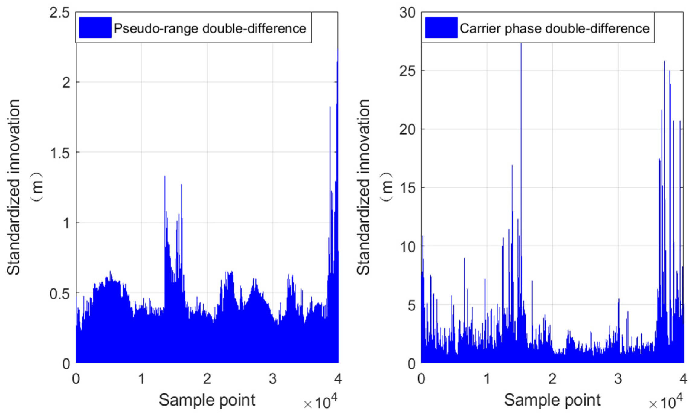
3.1. Dual-Factor Correlation Observation Robust Algorithm Considering Ambiguity Variance

Robust estimation is achieved by adjusting the weight of observations, with higher precision observations giving greater weight and lower precision observations giving smaller weight. When there are outliers in the observations, the equivalent covariance matrix R ¯ k is generated to adapt the corresponding variance and covariance:
R ¯ k = σ 1 2 σ 12 σ 1 n σ 21 σ 2 2 σ 2 n σ n 1 σ n 2 σ n 2 = λ 11 σ 1 2 λ 12 σ 12 λ 1 n σ 1 n λ 21 σ 21 λ 22 σ 2 2 λ 2 n σ 2 n λ n 1 σ n 1 λ n 2 σ n 2 λ n n σ n 2
where, σ ¯ i 2 and σ ¯ i j represents equivalent variance and equivalent covariance, respectively. λ i j = λ i i λ j j , ensuring that the correlation between observations is not changed. λ i i represents the variance inflation factor. The classic robust factor model includes two segment weight functions and three segment weight functions [22,23]. The two segment weight function models can be represented as
λ i i = 1 , v ~ i = v i σ v i c v ~ i c , v ~ i > c
where c represents the decision factor, and v ~ i represents standardized innovation. σ v i denotes the variance of the observation residual v i .
RTK double-differenced observations including pseudo range and carrier phase have different stochastic characteristics, so the calculated normalized innovation has different stochastic characteristics, as shown in Figure 2. The normalization innovation of pseudo-range double-differenced is smaller than that of carrier phase double-differenced. It follows that it is unreasonable to use a uniform threshold to discriminate abnormal double differences. Dual-factor robust estimation models were constructed:
λ i i , p = 1 , v ~ i = v i σ v i c 1 v ~ i c 1 , v ~ i > c 1 , λ j j , φ = 1 , v ~ i = v i σ v i c 2 v ~ i c 2 , v ~ i > c 2
where λ i i , p denotes the variance inflation factor of the double-differenced pseudo-range, λ j j , φ denotes the variance inflation factor of the double-differenced carrier phase, and c1 and c2 denote the corresponding robust estimation thresholds, respectively, and from a large number of examples similar to Figure 2, it can be concluded that the experience of c2 is usually smaller than c1.
The fixed ambiguity and the accuracy of filtering solutions in tightly coupled integration are easily affected by single-differenced ambiguity with cycle slips, which can lead to poor positioning performance of the tightly coupled system in urban with frequent cycle slips. Therefore, while adjusting the covariance matrix of double-differenced observations, the variance of single-differenced carrier phase ambiguity should also be adjusted:
σ ¯ N i 2 = σ N i 2 , v i 2 n σ v i 2 30.0 , v i 2 > n σ v i 2
where n is the threshold set based on experience, which is generally set to be stricter than the threshold for robust observations related to two factors, σ N i 2 is the variance of the single-differenced ambiguity N i .
According to the equivalent variance calculated by the above model, recalculate the gain matrix in KF,
K ¯ k = P k , k 1 H k T H k P k , k 1 H k T + R ¯ k 1
where P k , k 1 denotes state one-step prediction mean square error matrix, K ¯ k represents the robust gain matrix calculated based on equivalent variance R ¯ k .

3.2. Innovation-Based Adaptive Estimation

In the RTK/INS navigation solution, due to the irregularity of carrier motion, the dynamic function model used to describe state parameters in KF cannot fully and accurately describe the actual movement of the carrier, which affects the accuracy of parameter solution. The state vector error predicted by KF based on dynamic models can be expressed as
V X k = X k X k , k 1 = X k Φ k , k 1 X k 1
where Φ k , k 1 represents the state transition matrix, X k , k 1 represents one-step prediction of state. V X k represents the impact of dynamic model accuracy on state parameter estimation; based on the state parameter error vector, establish an adaptive function as follows [46]:
α i = 1 , Δ X ˜ i c m c m ( c n Δ X ˜ i ) / ( c n c m ) , c n > Δ X ˜ i > c m 0 , Δ X ˜ i c n
where c n and c m represent empirical thresholds, respectively; when the adaptive factor alpha is 0, the adaptive KF solution will degenerate into a special form of the least square solution, and
Δ X ˜ k = X k Φ k , k 1 X k 1 / t r P k , k 1
In (11), t r (   ) represents the trace operation. In summary, the adaptive solution of KF can be obtained as follows:
X ˆ k = X k , k 1 + K ˆ k Z k H k X k , k 1
P ˆ k = I K ˆ k H k P k , k 1 I K ˆ k H k T + K ˆ k R k K ˆ k T
where
K ˆ k = 1 α P k , k 1 H k T 1 α H k P k , k 1 H k T + R k 1

3.3. Multi-Condition Decision Model

Whether it is the dynamic model or the observation model that experiences anomalies, it will lead to gross errors in the final integrated navigation results, affecting the overall positioning performance of the system. Misjudgment of the source of abnormal information can further deteriorate the accuracy of integrated navigation. A reasonable robust adaptive decision-making model is the key to ensuring the effectiveness of robust adaptive algorithms.

3.3.1. NHC Decision Model

NHC is usually used as a constraint condition to improve the positioning accuracy and reliability of integrated navigation systems. In fact, NHC can also serve as an important reference for robust adaptive decision-making before GNSS measurement updates in coupled navigation systems. The idea is that when the velocity in either the rightward or upward directions relative to the b-frame are not nearly zero v x b 0 , v z b 0 , it is considered that there is an error in the INS, and innovation-based adaptive estimation is performed.

3.3.2. Abnormal Innovation Proportion Decision Model

The filtering innovation reflects the consistency between observation and state estimation. The gross error between the innovation detection system model and the observation model can be utilized. When the proportion of gross errors detected in the innovation sequence is too large (Wu [46] set the threshold to 75%), while ensuring that GNSS has redundant observation values, it is considered that there are gross errors in the inertial navigation prediction information and the filtering variance needs to be reset. To cope with complex environments, fixed thresholds are inaccurate and dynamic thresholds should be used. A model that can adjust the proportional threshold based on the current available observations should be proposed.
T h r e s h o l d = 0.1 × ( 100 n u s e ) × 0.1
where n u s e is the current number of available observations, and ⌊ ⌋ represents the rounding-down operator.

3.3.3. Multi Condition Decision Strategy

A multi-condition decision model considering NHC decision model, GNSS outage time, and abnormal innovation proportion decision model is proposed. The pseudocode is listed in Algorithm 1.
Algorithm 1: New robust adaptive scheme considering multi-condition strategies
1 k 1
2Process {Initialization, System buffer}
3while no abort command received do
4     k k + 1
5    Process {State update}
6    if  v x b = 0 , v z b = 0 , P r o c e s s { N H C   u p d a t e } , end
7    if ( e x i s t s G N S S = F a l s e ), continue
8    else
9        P r o c e s s { A d j u s t   t h e   t h r e s h o l d   u s i n g ( 15 ) }
10       if ( R a t i o a b n o r m a l   i n n o v a t i o n > T h r e s h o l d )
11           P r o c e s s { A d a p t i v e   K F   u s i n g   ( 12 )   a n d   ( 13 ) }
12       else
13          if ( T G N S S   o u t a g e > T T h r e s h o l d )
14              P r o c e s s { A d a p t i v e   K F   u s i n g   ( 12 )   a n d   ( 13 ) }
15          else
16             if  v x b 0 , v z b 0
17                P r o c e s s { A d a p t i v e   K F   u s i n g   ( 12 )   a n d   ( 13 ) }
18             else
19                P r o c e s s { R o b u s t   K F   u s i n g   ( 4 )   a n d   ( 8 ) }
20             end if
21          end if
22       end if
23  end if
24end while
This method not only uses the NHC decision model for robust adaptive decision making but also preserves NHC updates, enabling the integrated navigation system to maintain positioning accuracy in GNSS interruption scenarios, such as tunnels and indoor environments. GNSS outage time is introduced as a judgment condition to ensure the ability of decision model to distinguish INS cumulative error. Subsequently, a decision model for the proportion of abnormal innovation was introduced to improve the accuracy of the decision model in making robust adaptive decisions in complex environments.

4. Test Cases and Results Analysis

Two sets of vehicular test cases are conducted to evaluate the performance of the proposed novel optimal robust adaptive-scheme-based GNSS-RTK/INS tightly coupled navigation system. The field tests were conducted in typical complex urban environments such as viaducts, tunnels, avenues, and urban canyons, all of which provided reference truth values using high-precision integrated navigation equipment to more intuitively reflect the performance of the proposed method. Test case 1 was collected from a set of open-source data in Tokyo to verify the feasibility of the proposed algorithm. Test case 2 was collected in the urban environment of Wuhan City, Hubei Province. We have established an algorithm verification platform to verify the performance of the algorithm.
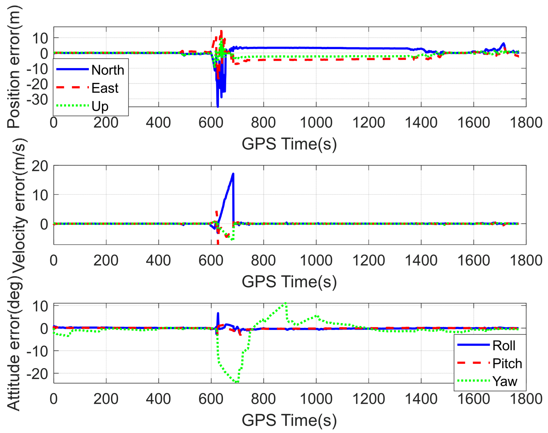
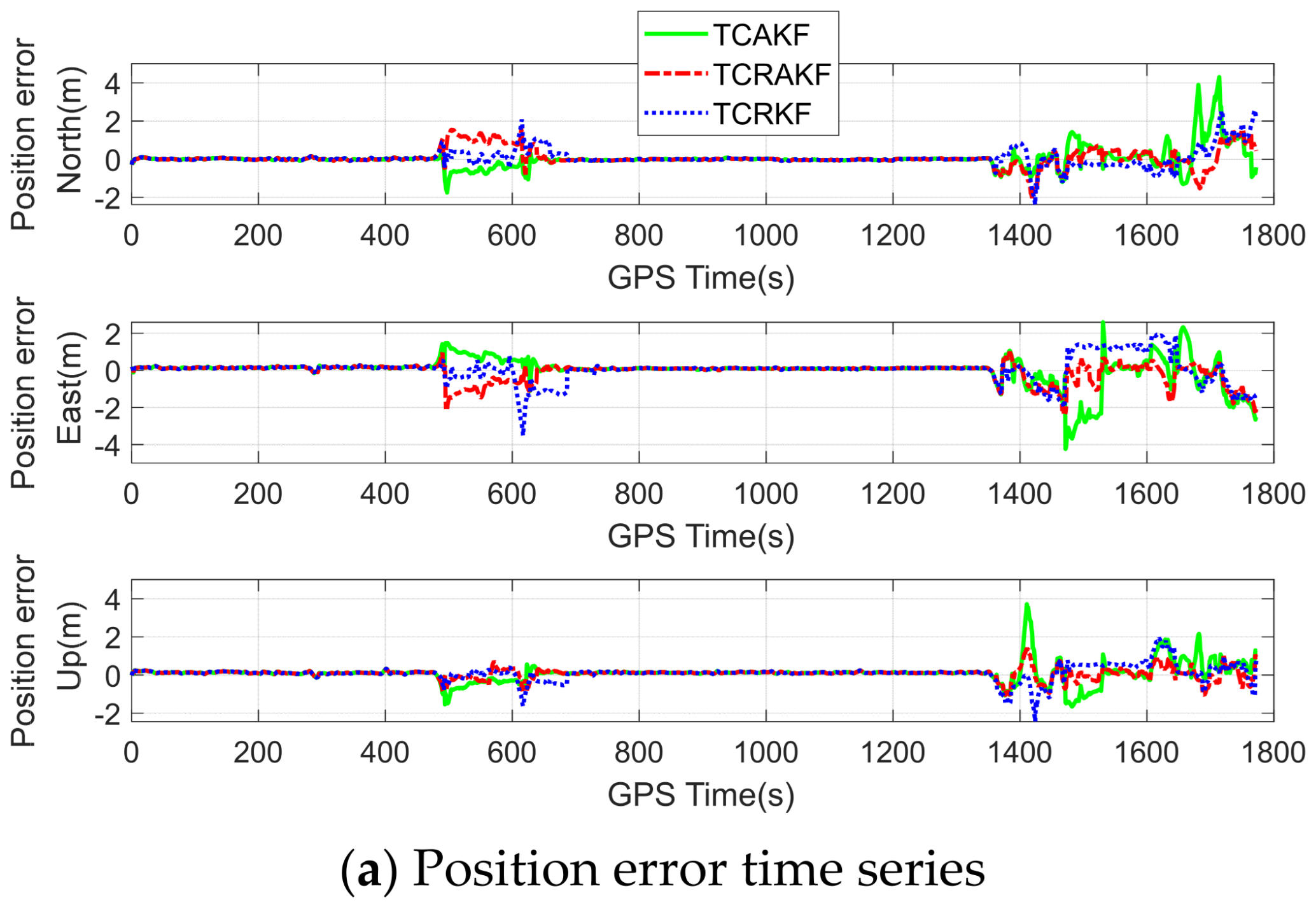
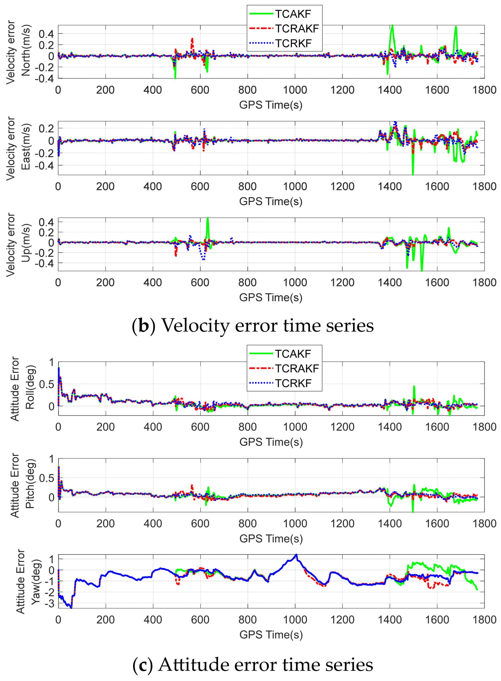
  • Test 1: Experiments in challenging and complex urban scenes of Tokyo
An open-source multi-sensor dataset collected in the Tokyo urban area was used to verify the generalizability of the proposed algorithm [47]. The data collection platform is equipped with a variety of sensors, including GNSS receivers and low-cost IMU. Applanix POS LV620 (RMSE: 5 cm) was used to provide ground truth, low-cost IMU (Tamagawa-seiki TAG264, 50 Hz) output of 6-axis inertial data and GNSS receiver (u-blox F9P (5 Hz) and Trimble NetR9 (10 Hz)) output observations are used for algorithm analysis and validation.
The GNSS dataset from Tokyo, which is collected in urban canyons, is challenging. Most of the time, the number of the global positioning system (GPS) satellites is only four, while BDS has slightly more satellites. This can be seen from the GPS/BDS satellite sky plot (left), available satellites (top right), and PDOP (bottom right) in Figure 3. In this test, the main analysis is the difference between enabling and not enabling the new robust adaptation proposed under the RTK/INS tightly coupled integration framework. As a classic filtering method for GNSS/INS integrated navigation, the loosely coupled integration method also participates in the analysis of its filtering results, which are presented in Figure 4.
Figure 4 shows a two-dimensional trajectory of three data processing results and reference results. It can be found that the proposed robust adaptive RTK/INS tightly coupled (TCRAKF) scheme and RTK/INS tightly coupled (TCKF) scheme are in good agreement with the reference trajectory. The RTK/INS loosely coupled (LCKF) scheme has large outlier in some challenging scenarios. The GNSS and INS in the loosely coupled framework fuse information at the result level of the two subsystems. When GNSS positioning fails continuously, the navigation system will have large outliers.
Figure 5 shows the position errors and their 2σ bounds of the TCKF (left) and TCRAKF (right) solutions in the east, north, and up axes. Obviously, the root-mean-square error (RMS) of the three axes of the TCKF scheme is larger, with values of 1.4461 m, 1.4666 m, and 2.7520 m, respectively. The error sequence of the TCRAKF scheme changes relatively smoothly, with RMS values of 0.9671 m, 1.0352 m, and 0.9477 m, respectively. The 2σ bound of TCKF does not envelop its error well, and its variance covariance does not reflect the credibility of the filtering solution. However, the 2σ limit of TCRAKF effectively envelops the error and accurately reflects the credibility of the filtering solution.
Furthermore, the improvement of accuracy is introduced to evaluate the positioning performance of TCRAKF. The accuracy improvement is defined as follows:
I = R M S T C K F R M S T C R A K F R M S T C K F
For these test data, the accuracy improvements of the TCRAKF scheme with the TCKF scheme are illustrated in Figure 6. The improvements in position, velocity, and attitude in RMS are about 78%, 55%, and 65%, respectively. The improvement in the east north up axial position of RMS are approximately 33.1%, 29.4%, and 65.6%, respectively. In the application of global navigation satellite system positioning, the proposed new robust adaptive scheme shows significant improvement in the position accuracy of the RTK/INS tightly coupled integration.
  • Test 2: Performance verification of complex urban scenes in Wuhan
Build an in-vehicle test software and hardware platform to carry out in-vehicle testing in a complex GNSS environment. The two sensors, GNSS antenna and IMU, are fixed on the roof of the test vehicle through a high-stiffness aluminum plate, and the multi-source data collected are used to analyze and verify the RTK/INS tightly coupled robust adaptive algorithm. The M39 integrated navigation system of MPSTNAV and its built-in automotive-grade MEMS-IMU output 200 Hz inertial data and multi-frequency multi-mode GNSS receiver output 1 Hz pseudo-range and carrier phase data for the proposed algorithm were selected as the test equipment. For performance analysis, the base station data is provided by the PANDA receiver of Panda-GNSS in Wuhan, and its data sampling rate is set to 1 Hz. The receiver is installed on the roof of Yinhai-Yayuan, with a wide field of view and no signal interference. The high-precision SPAN-CPT6 split-type integrated navigation system produced by NovAtel in Canada was selected as the reference device, and its high-precision navigation parameters, including position, velocity, attitude, and other information were projected to the reference center of the device under test as the reference value. In the test, the performance parameters of the two IMUs are shown in Table 1.
The test field is the real urban environment of Wuhan City, with an area of 14 km2, of which the longest baseline between the base station and rover does not exceed 7 km. During the test, the vehicle has rich dynamic information, including multiple accelerations, decelerations, and turns. The test environment includes a variety of typical complex environments, such as avenues, urban areas, tunnels, and viaducts, which pose a huge challenge to high-precision GNSS positioning. The obtained trajectory and typical scene of the proposed algorithm are depicted in Figure 7. Figure 8 is the satellite sky plot of GPS/BDS, the number of available satellites, and the position dilution of precision (PDOP). It can be seen from the figure that the number of satellites frequently plummets, demonstrating the challenges of integrated navigation and positioning systems in complex environments.
In this test, the tightly coupled RTK/INS solution is adopted to analyze the performance of the proposed robust adaptive algorithm. Figure 9 shows the double-differenced pseudo-range innovation sequences of all visible satellites with GPS+BDS when the elevation mask is 15°. It can be seen from the figure that there are several large outliers (points in the yellow circle) in the double-differenced pseudo-range observations. Most of the pseudo-range observations correspond to filtering innovations within ±2 m, but there are also innovations in many epochs with small deviations. Therefore, a robust adaptive filtering scheme is necessary to obtain a reliable fixed ambiguity. Figure 10 shows the forward KF results of the RTK/INS tightly coupled integration (TCKF). It can be found that decimeter-level positioning accuracy and centimeter-level velocity accuracy are approachable but are not stable or globally optimal in GNSS weak signal scenarios. Overall, the accuracy of forward KF estimation cannot satisfy the requirements of high-precision navigation and positioning.
To analyze the performance of the proposed optimal robust adaptive algorithms in the RTK/INS tightly coupled integration systems, three data processing schemes were evaluated, including the adaptive RTK/INS tightly coupled filtering (TCAKF) scheme, the robust RTK/INS tightly coupled filtering (TCRKF) scheme, and the proposed modified robust adaptive filtering (TCRAKF) scheme based on multi-conditional decision making. All three schemes use the RTK of dual-frequency GPS+BDS and use the “Fixed and Hold” mode for processing to correctly fix the ambiguity of all epochs, thus evaluating the positioning accuracy. A comparison of the results is shown in Figure 11.
Obviously, compared to the TCKF scheme in Figure 10, the performance of the three robust adaptive data processing schemes in Figure 11 is significantly improved, especially for velocity and attitude. Among the three robust adaptive data processing schemes, the TCAKF scheme still has large errors for many times, but the TCRAKF scheme in the same scenario does not have large errors. According to these results, it is demonstrated that the proposed revised robust adaptive scheme is applicable for RTK/INS tightly coupled integration.
Figure 12 is a boxplot of the error sequences in position (top), velocity (middle), and attitude (bottom) for three robust adaptive filtering schemes. The boxplot is a standard way of displaying the distribution of data based on a five number summary: the minimum value, the first quantile, the median, the third quantile, and the maximum value. Table 2 illustrates the RMS of position, velocity, and attitude components. With the new robust adaptive scheme, the mean position RMS significantly improves from (3.5867, 3.2904, 1.7082) m to (0.4339, 0.4951, 0.2757) m in the north, east, and up directions, respectively, resulting in a 3D mean accuracy improvement of 86.16%. The mean attitude RMS improves from (0.4040, 0.3446, 5.3014) degrees to (0.1090, 0.0885, 0.9634) degrees in the yaw, pitch, and roll directions, respectively, which is a 3D mean accuracy improvement of 81.73%. Compared with the TCAKF and TCRKF algorithms, the new robust adaptive scheme improves the average 3D position RMS by 31% and 18.88%, respectively. This indicates that in general, the estimation accuracy for the new smoothing scheme is superior to that for the TCAKF and TCEKF algorithms.

5. Discussion

Due to the limited observation quality of GNSS and the performance of IMU, the positioning accuracy of the GNSS RTK/INS integrated navigation system will rapidly deteriorate in complex environments such as tunnels, viaducts, and urban areas. The robust adaptive algorithm is a key technology to solve the above problems. The robust adaptive algorithm generally includes three parts: robust estimation, adaptive KF, and strategy. Robust estimation is used to reduce the impact of observation gross errors, adaptive KFs are used to reduce the impact of dynamic errors, and robust adaptive strategies are used to make reasonable decisions between robust algorithms and adaptive algorithms. They are the key to reducing the positioning error of tree-lined and urban canyon environments.
The proposed algorithm reduces the positioning error of the vehicle GNSS RTK/INS tightly coupled integrated navigation system in complex environments and improves the robustness and adaptability of the integrated navigation system. However, there are still some shortcomings in the algorithm proposed in this paper, and further research is needed to improve it. The proposed tightly coupled system ignores the ionospheric and tropospheric errors in GNSS double-difference observations, which is feasible in short baseline situations but will reduce positioning performance in long baseline situations.

6. Conclusions

A novel robust adaptive scheme based on tightly coupled RTK/INS is proposed to improve the absolute accuracies of position and orientation. The integrated strategy is as follows: first, based on the comprehensive NHC decision model and the abnormal innovation proportion decision model, a multi-condition decision model was constructed. Then, the innovation adaptive algorithm and the dual-factor robust algorithm considering ambiguity variance were applied to the tightly coupled architecture. We conducted a performance assessment of the new robust adaptive scheme under urban environment. It was demonstrated that the novel scheme is superior to the conventional robust adaptive algorithms.
In fact, the proposed robust adaptive algorithm is not only applicable to tightly coupled RTK/INS architecture but can also provide experience for robust adaptive methods such as tightly coupled PPP/INS. In complex GNSS environments, such as urban centers, GNSS observations are inevitably affected by multi-path errors, thereby reducing the reliability of GNSS/INS integration positioning. It is suggested that the novel robust adaptive scheme should be adopted to obtain the optimal solution.

Author Contributions

All authors contributed to this article. Conceptualization, J.W. and J.J.; methodology, J.W. and C.Z.; software, J.W. and C.Z.; validation, J.W. and Y.L.; formal analysis, J.W. and P.Y.; investigation, J.J. and J.W.; writing—original draft preparation, J.W.; writing—review and editing, J.J., Y.L., X.M. and P.Y.; visualization, J.W.; supervision, J.J.; project administration, J.W.; funding acquisition, J.J. and X.M. All authors have read and agreed to the published version of the manuscript.

Funding

This research was funded by the National Key Research and Development Program of China (2021YFB2501102).

Data Availability Statement

The data collected and analyzed supporting the current research are available from the corresponding author on reasonable request.

Acknowledgments

The authors would like to thank all group members in Jinguang Jiang’s group for the good working environment and Li Ta Hsu’s team form the Hong Kong Polytechnic university for providing open source data.

Conflicts of Interest

The authors declare no conflict of interest.

References

  1. Yang, F.; Zhao, L.; Li, L.; Feng, S.; Cheng, J. Performance Evaluation of Kinematic BDS/GNSS Real-Time Precise Point Positioning for Maritime Positioning. J. Navig. 2019, 72, 34–52. [Google Scholar] [CrossRef]
  2. Yi, Q.W.; Yu, B.G.; Wang, B.B.; Sheng, C.Z. A Precise Point Timing Method Based on BDS-3 B2b Signal. Acta Electron. Sin. 2022, 50, 832–840. [Google Scholar]
  3. Ge, Y.; Ding, S.; Qin, W.; Zhou, F.; Yang, X.; Wang, S. Performance of ionospheric-free PPP time transfer models with BDS-3 quad-frequency observations. Measurement 2020, 160, 107836. [Google Scholar] [CrossRef]
  4. Zhang, X.; Zhu, F.; Tao, X.; Duan, R. New optimal smoothing scheme for improving relative and absolute accuracy of tightly coupled GNSS/SINS integration. GPS Solut. 2017, 21, 861–872. [Google Scholar] [CrossRef]
  5. Godha, S.; Cannon, M.E. GPS/MEMS INS integrated system for navigation in urban areas. GPS Solut. 2007, 11, 193–203. [Google Scholar] [CrossRef]
  6. Yan, P.; Jiang, J.; Zhang, F.; Xie, D.; Wu, J.; Zhang, C.; Tang, Y.; Liu, J. An Improved Adaptive Kalman Filter for a Single Frequency GNSS/MEMS-IMU/Odometer Integrated Navigation Module. Remote Sens. 2021, 13, 4317. [Google Scholar] [CrossRef]
  7. Wang, M.; Yu, P.; Li, Y. Performance analysis of GNSS/INS loosely coupled integration systems under GNSS signal blocking environment. E3S Web Conf. 2020, 206, 02013. [Google Scholar] [CrossRef]
  8. Li, W.; Li, W.; Cui, X.; Zhao, S.; Lu, M. A Tightly Coupled RTK/INS Algorithm with Ambiguity Resolution in the Position Domain for Ground Vehicles in Harsh Urban Environments. Sensors 2018, 18, 2160. [Google Scholar] [CrossRef] [Green Version]
  9. Gao, B.; Hu, G.; Zhong, Y.; Zhu, X. Cubature Kalman filter with both adaptability and robustness for tightly-coupled GNSS/INS integration. IEEE Sens. J. 2021, 21, 14997–15011. [Google Scholar] [CrossRef]
  10. Zhang, L.; Viktorovich, P.A.; Selezneva, M.S.; Neusypin, K.A. Adaptive Estimation Algorithm for Correcting Low-Cost MEMS-SINS Errors of Unmanned Vehicles under the Conditions of Abnormal Measurements. Sensors 2021, 21, 623. [Google Scholar] [CrossRef]
  11. Wu, Y.; Chen, S.; Yin, T. GNSS/INS Tightly Coupled Navigation with Robust Adaptive Extended Kalman Filter. Int. J. Automot. Technol. 2022, 23, 1639–1649. [Google Scholar] [CrossRef]
  12. Zhou, Y.; Chen, Q.; Niu, X. Kinematic Measurement of the Railway Track Centerline Position by GNSS/INS/Odometer Integration. IEEE Access 2019, 7, 157241–157253. [Google Scholar] [CrossRef]
  13. Yan, P.; Jiang, J.; Tang, Y.; Zhang, F.; Xie, D.; Wu, J.; Liu, J.; Liu, J. Dynamic Adaptive Low Power Adjustment Scheme for Single-Frequency GNSS/MEMS-IMU/Odometer Integrated Navigation in the Complex Urban Environment. Remote Sens. 2021, 13, 3236. [Google Scholar] [CrossRef]
  14. Xia, X.; Meng, Z.; Han, X.; Li, H.; Tsukiji, T.; Xu, R.; Zheng, Z.; Ma, J. An automated driving systems data acquisition and analytics platform. Transp. Res. Part C Emerg. Technol. 2023, 151, 104120. [Google Scholar] [CrossRef]
  15. Zonglin, M.; Xin, X.; Runsheng, X.; Wei, L.; Jiaqi, M. HYDRO-3D: Hybrid Object Detection and Tracking for Cooperative Perception Using 3D LiDAR. IEEE Trans. Intell. Veh. 2023, 99, 1–13. [Google Scholar]
  16. Liu, W.; Quijano, K.; Crawford, M.M. YOLOv5-Tassel: Detecting Tassels in RGB UAV Imagery with Improved YOLOv5 Based on Transfer Learning. IEEE J. Sel. Top. Appl. Earth Obs. Remote Sens. 2022, 15, 8085–8094. [Google Scholar] [CrossRef]
  17. Xia, X.; Xiong, L.; Huang, Y.; Lu, Y.; Gao, L.; Xu, N.; Yu, Z. Estimation on IMU yaw misalignment by fusing information of automotive onboard sensors. Mech. Syst. Signal Process. 2022, 162, 107993. [Google Scholar] [CrossRef]
  18. Elzoghby, M.; Arif, U.; Li, F.; Yu, X.Z. Investigation of adaptive robust Kalman filtering algorithms for GPS/DR navigation system filters. IOP Conf. Ser. Mater. Sci. Eng. 2017, 187, 012019. [Google Scholar] [CrossRef]
  19. Liu, W.; Shi, Y.; Hu, Y.; Hsieh, T.H.; Wang, S. An improved GNSS/INS navigation method based on cubature Kalman filter for occluded environment. Meas. Sci. Technol. 2022, 34, 035107. [Google Scholar] [CrossRef]
  20. Xu, Y.; Wang, K.; Jiang, C.; Li, Z.; Yang, C.; Liu, D.; Zhang, H. Motion-Constrained GNSS/INS Integrated Navigation Method Based on BP Neural Network. Remote Sens. 2023, 15, 154. [Google Scholar] [CrossRef]
  21. Yu, H.; Han, H.; Wang, J.; Xiao, H.; Wang, C. Single-Frequency GPS/BDS RTK and INS Ambiguity Resolution and Positioning Performance Enhanced with Positional Polynomial Fitting Constraint. Remote Sens. 2020, 12, 2374. [Google Scholar] [CrossRef]
  22. Yang, Y.; Gao, W.; Zhang, X. Robust Kalman filtering with constraints: A case study for integrated navigation. J. Geod. 2010, 84, 373–381. [Google Scholar] [CrossRef]
  23. Lin, X.; Yang, X.; Hu, C.; Li, W. Improved forward and backward adaptive smoothing algorithm. GPS Solut. 2022, 26, 2. [Google Scholar] [CrossRef]
  24. Chiang, K.W.; Lin, C.A.; Peng, K.Y. The Performance Analysis of an AKF Based Tightly-Coupled INS/GNSS Sensor Fusion Scheme with Non-Holonomic Constraints for Land Vehicular Applications. Appl. Mech. Mater. 2013, 284–287, 1956–1960. [Google Scholar] [CrossRef]
  25. Xia, X.; Hashemi, E.; Xiong, L.; Khajepour, A. Autonomous Vehicle Kinematics and Dynamics Synthesis for Sideslip Angle Estimation Based on Consensus Kalman Filter. IEEE Trans. Control. Syst. Technol. 2023, 31, 179–192. [Google Scholar] [CrossRef]
  26. Wei, L.; Lu, X.; Yishi, L.; Letian, G.; Zhuoping, Y. Automated Vehicle Sideslip Angle Estimation Considering Signal Measurement Characteristic. IEEE Sens. J. 2021, 21, 21675–21687. [Google Scholar]
  27. Xiong, L.; Xia, X.; Lu, Y.; Liu, W.; Gao, L.; Song, S.; Yu, Z. IMU-Based Automated Vehicle Body Sideslip Angle and Attitude Estimation Aided by GNSS Using Parallel Adaptive Kalman Filters. IEEE Trans. Veh. Technol. 2020, 69, 10668–10680. [Google Scholar] [CrossRef]
  28. Liu, W.; Xiong, L.; Xia, X.; Lu, Y.; Gao, L.; Song, S. Vision-aided Intelligent Vehicle Sideslip Angle Estimation Based on Dynamic Model. IET Intell. Transp. Syst. 2020, 14, 1183–1189. [Google Scholar] [CrossRef]
  29. Wen, W.; Kan, Y.C.; Hsu, L.T. Performance comparison of GNSS/INS integrations based on EKF and factor graph optimization. In Proceedings of the 32nd International Technical Meeting of the Satellite Division of The Institute of Navigation, Miami, FL, USA, 16–20 September 2019; pp. 3019–3032. [Google Scholar]
  30. Falco, G.; Pini, M.; Marucco, G. Loose and tight GNSS/INS integrations: Comparison of performance assessed in real urban scenarios. Sensors 2017, 17, 255. [Google Scholar] [CrossRef]
  31. Li, Y.; Mi, J.; Xu, Y.; Li, B.; Jiang, D.; Liu, W. A Robust Adaptive Filtering Algorithm for GNSS Single-Frequency RTK of Smartphone. Remote Sens. 2022, 14, 6388. [Google Scholar] [CrossRef]
  32. Li, B.; Chen, G. Improving the combined GNSS/INS positioning by using tightly integrated RTK. GPS Solut. 2022, 26, 144. [Google Scholar] [CrossRef]
  33. Yang, Y. Adaptively Robust Kalman Filters with Applications in Navigation. In Adaptive Navigation and Kinematic Positioning, 2nd ed.; SinoMaps: Beijing, China, 2017; pp. 50–75. [Google Scholar]
  34. Yang, Y.; He, H.; Xu, G. Adaptively robust filtering for kinematic geodetic positioning. J. Geod. 2001, 75, 109–116. [Google Scholar] [CrossRef]
  35. Dong, Y.; Wang, D.; Zhang, L.; Li, Q.; Wu, J. Tightly Coupled GNSS/INS Integration with Robust Sequential Kalman Filter for Accurate Vehicular Navigation. Sensors 2020, 20, 561. [Google Scholar] [CrossRef] [Green Version]
  36. Li, T.; Zhang, H.; Niu, X.; Zhang, Q. Performance Analysis of Tightly Coupled RTK/INS Algorithm in Case of Insufficient Number of Satellites. Geomat. Inf. Wuhan Univ. 2018, 43, 478–484. [Google Scholar]
  37. Shi, B.; Wang, M.; Wang, Y.; Bai, Y.; Lin, K.; Yang, F. Effect analysis of GNSS/INS processing strategy for sufficient utilization of urban environment observations. Sensors 2021, 21, 620. [Google Scholar] [CrossRef]
  38. Qiao, S.; Fan, Y.; Wang, G.; Mu, D.; He, Z. Radar Target Tracking for Unmanned Surface Vehicle Based on Square Root Sage–Husa Adaptive Robust Kalman Filter. Sensors 2022, 22, 2924. [Google Scholar] [CrossRef]
  39. Peng, Z.; Gao, C.; Shang, R. Application of Sage-Husa filter considering innovation vectors in mobile phone GNSS location. J. Navig. Position. 2020, 8, 76–81, 89. [Google Scholar]
  40. Zhao, X.; Qian, Y.; Zhang, M.; Niu, J.; Kou, Y. An improved adaptive Kalman filtering algorithm for advanced robot navigation system based on GPS/INS. In Proceedings of the 2011 IEEE International Conference on Mechatronics and Automation, Beijing, China, 7–10 August 2011; pp. 1039–1044. [Google Scholar]
  41. Yang, Z.; Li, Z.; Liu, Z.; Wang, C.; Sun, Y.; Shao, K. Improved robust and adaptive filter based on non-holonomic constraints for RTK/INS integrated navigation. Meas. Sci. Technol. 2021, 32, 105110. [Google Scholar] [CrossRef]
  42. Li, T.; Zhang, H.; Niu, X.; Gao, Z. Tightly-Coupled Integration of Multi-GNSS Single-Frequency RTK and MEMS-IMU for Enhanced Positioning Performance. Sensors 2017, 17, 2462. [Google Scholar] [CrossRef] [Green Version]
  43. Li, T.; Zhang, H.; Gao, Z.; Chen, Q.; Niu, X. High-Accuracy Positioning in Urban Environments Using Single-Frequency Multi-GNSS RTK/MEMS-IMU Integration. Remote Sens. 2018, 10, 205. [Google Scholar] [CrossRef] [Green Version]
  44. El-Sheimy, N.; Hou, H.; Niu, X. Analysis and modeling of inertial sensors using Allan variance. IEEE Trans. Instrum. Meas. 2008, 57, 140–149. [Google Scholar] [CrossRef]
  45. Elsobeiey, M.; El-Rabbany, A. Efficient between-satellite single-difference precise point positioning model. J. Surv. Eng. 2014, 140, 1009–1016. [Google Scholar] [CrossRef]
  46. Jiahao, W. Research on GNSS RTK/INS/Vehicle Auxiliary Information Tightly-Coupled Multi-Source Navigation and Positioning Algorithm. Master’s Thesis, Wuhan University, Wuhan, China, 2019. [Google Scholar]
  47. Hsu, L.T.; Kubo, N.; Wen, W.; Chen, W.; Liu, Z.; Suzuki, T.; Meguro, J. UrbanNav: An open-sourced multisensory dataset for benchmarking positioning algorithms designed for urban areas. In Proceedings of the 34th International Technical Meeting of the Satellite Division of The Institute of Navigation (ION GNSS+ 2021), St. Louis, MO, USA, 20–24 September 2021. [Google Scholar]
Figure 1. RTK/INS loosely coupled and tightly coupled architecture.
Remotesensing 15 03725 g001
Figure 2. Standardization innovation of double-differenced pseudo-range and carrier phase.
Remotesensing 15 03725 g002
Figure 3. Satellite sky plot (left) of GPS/BDS, the number of available satellites (top right), and the PDOP (bottom right).
Remotesensing 15 03725 g003
Figure 4. Test trajectory.
Remotesensing 15 03725 g004
Figure 5. Comparison of position errors between TCKF (left) and TCRAKF (right) solutions.
Remotesensing 15 03725 g005
Figure 6. Accuracy improvement of TCRAKF scheme with TCKF scheme.
Remotesensing 15 03725 g006
Figure 7. Trajectory and typical scene of the proposed algorithm, the longest baseline between the base station and rover does not exceed 7 km.
Remotesensing 15 03725 g007
Figure 8. Satellite sky plot (left) of GPS/BDS, the number of available satellites (top right), and the PDOP (bottom right).
Remotesensing 15 03725 g008
Figure 9. Double-differenced pseudo-range innovation sequence of all visible satellites of GPS + BDS when the elevation mask is 15°.
Remotesensing 15 03725 g009
Figure 10. Forward KF errors in position (top), velocity (middle), and attitude (bottom) for RTK/INS tightly coupled integration.
Remotesensing 15 03725 g010
Figure 11. Comparison of three adaptive robust filtering solutions under tight coupled integrated model. Plots from top to bottom show the errors in position, velocity, and attitude, respectively.
Remotesensing 15 03725 g011aRemotesensing 15 03725 g011b
Figure 12. Boxplot of the error sequences in position (top), velocity (middle), and attitude (bottom) for three robust adaptive filtering schemes.
Remotesensing 15 03725 g012
Table 1. Performance specifications of inertial sensors.
Sensor ParametersM39SPAN-CPT
Gyro Range±100 deg/s±375 deg/s
Gyro Bias Instability8 deg/hr1 deg/hr
Angular Random Walk0.12 deg/hr0.50.0667 deg/hr0.5
Accel. Range±5 g±10 g
Accel. Bias Instability0.2 mg0.75 mg
All parameters in the table are typical values at 25 °C.
Table 2. Comparison of different estimation schemes in terms of accuracy.
Position RMS (m)Velocity RMS (m/s)Attitude RMS (deg)
NorthEastUpNorthEastUpRollPitchYaw
TCKF3.58673.29041.70821.85480.62020.68890.40400.34465.3014
TCAKF0.53620.72870.50150.06910.06200.06350.10970.09970.9190
TCRKF0.44960.63930.40390.03960.04560.04320.10610.08960.9119
New scheme0.43390.49510.27570.02800.04510.02820.10900.08850.9634
Disclaimer/Publisher’s Note: The statements, opinions and data contained in all publications are solely those of the individual author(s) and contributor(s) and not of MDPI and/or the editor(s). MDPI and/or the editor(s) disclaim responsibility for any injury to people or property resulting from any ideas, methods, instructions or products referred to in the content.

