


Semantic Segmentation of China’s Coastal Wetlands Based on Sentinel-2 and Segformer
 ,
,  ,
,
Abstract
:1. Introduction
2. Study Area and Data Preprocessing
2.1. Study Area
2.2. Data Collection
2.3. Wetland Classification
2.4. Production of Data Sets
2.5. Data Enhancement and Data Filtering
3. Method
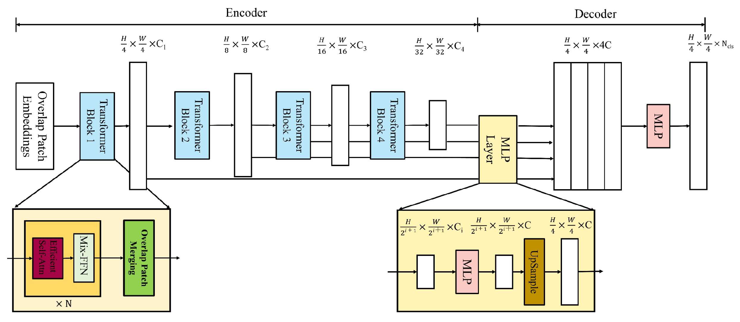
3.1. Model
3.1.1. Encoder
3.1.2. Overlapped Patch Embeddings
3.1.3. Overlapped Patch Merging
3.1.4. Efficient Self-Attention
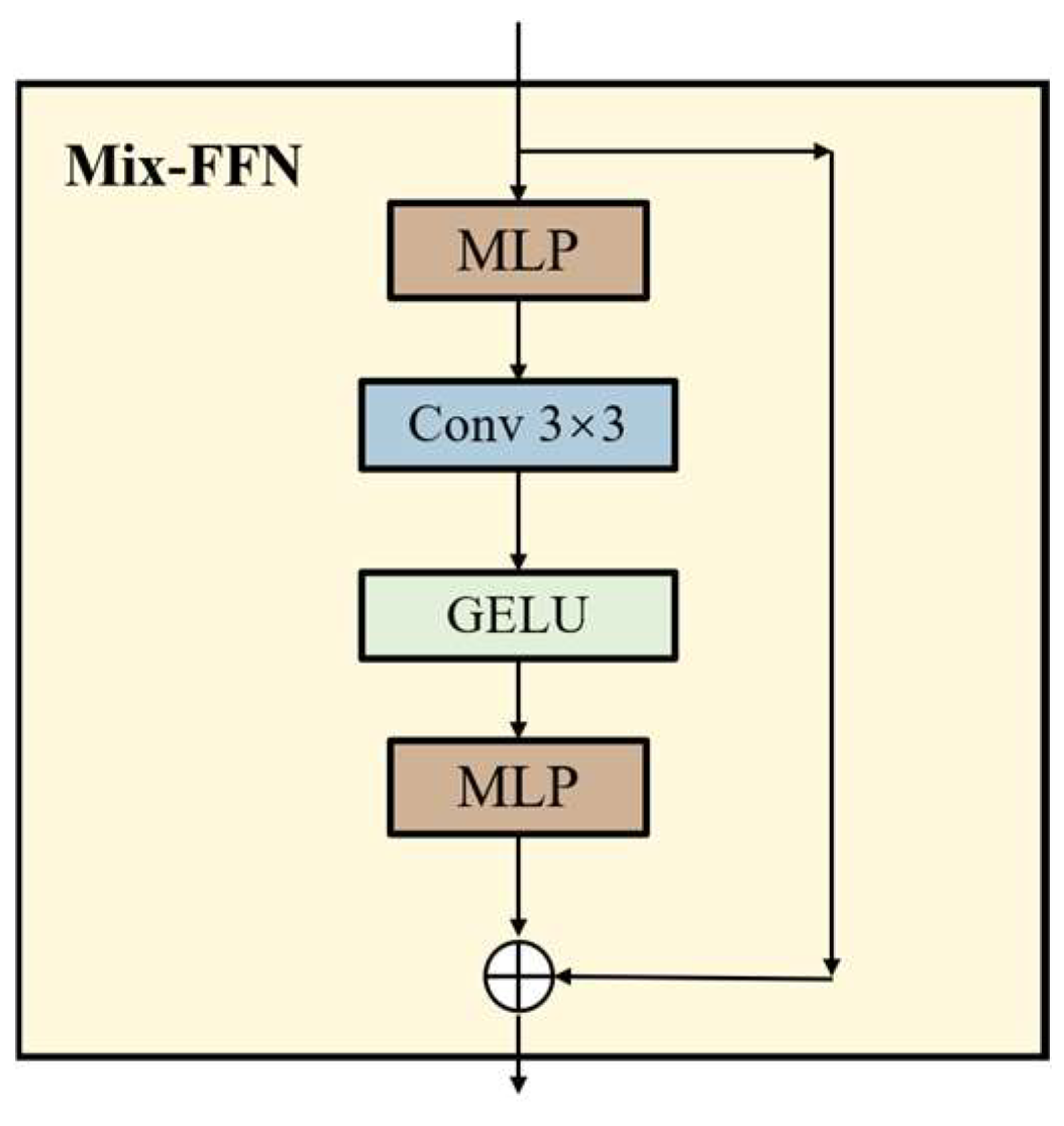
3.1.5. Mix-FFN
3.2. Lightweight All-MLP Decoder
3.3. Model Training
3.4. Evaluation Metrics
4. Experiments and Results
Results with Different Models
5. Discussion
5.1. Results with Different Loss Functions
5.2. Coastal Wetland Detection
6. Conclusions
Author Contributions
Funding
Data Availability Statement
Conflicts of Interest
References
- Bansal, S.; Katyal, D.; Garg, J.K. A novel strategy for wetland area extraction using multispectral MODIS data. Remote Sens. Environ. 2017, 200, 183–205. [Google Scholar] [CrossRef]
- LoweDavid, G. Distinctive Image Features from Scale-Invariant Keypoints. Int. J. Comput. Vis. 2004, 60, 91–110. [Google Scholar]
- Judah, A.; Hu, B. An Advanced Data Fusion Method to Improve Wetland Classification Using Multi-Source Remotely Sensed Data. Sensors 2022, 22, 8942. [Google Scholar] [CrossRef] [PubMed]
- Suir, G.M.; Jackson, S.; Saltus, C.; Reif, M.K. Multi-Temporal Trend Analysis of Coastal Vegetation Using Metrics Derived from Hyperspectral and LiDAR Data. Remote Sens. 2023, 15, 2098. [Google Scholar] [CrossRef]
- Amani, M.; Brisco, B.; Mahdavi, S.; Ghorbanian, A.; Moghimi, A.; DeLancey, E.R.; Merchant, M.A.; Jahncke, R.; Fedorchuk, L.; Mui, A.; et al. Evaluation of the Landsat-Based Canadian Wetland Inventory Map Using Multiple Sources: Challenges of Large-Scale Wetland Classification Using Remote Sensing. IEEE J. Sel. Top. Appl. Earth Obs. Remote Sens. 2021, 14, 32–52. [Google Scholar] [CrossRef]
- Li, A.; Song, K.; Chen, S.; Mu, Y.; Xu, Z.; Zeng, Q. Mapping African wetlands for 2020 using multiple spectral, geo-ecological features and Google Earth Engine. ISPRS J. Photogramm. Remote Sens. 2022, 193, 252–268. [Google Scholar] [CrossRef]
- Gxokwe, S.; Dube, T.; Mazvimavi, D. Leveraging Google Earth Engine platform to characterize and map small seasonal wetlands in the semi-arid environments of South Africa. Sci. Total Environ. 2021, 803, 150139. [Google Scholar] [CrossRef]
- Maulik, U.; Chakraborty, D. Learning with transductive SVM for semisupervised pixel classification of remote sensing imagery. Isprs J. Photogramm. Remote Sens. 2013, 77, 66–78. [Google Scholar] [CrossRef]
- Ahmed, K.R.; Akter, S.; Marandi, A.; Schüth, C. A simple and robust wetland classification approach by using optical indices, unsupervised and supervised machine learning algorithms. Remote Sens. Appl. Soc. Environ. 2021, 23, 100569. [Google Scholar] [CrossRef]
- Fu, B.; Wang, Y.; Campbell, A.D.; Li, Y.; Zhang, B.; Yin, S.; Xing, Z.; Jin, X. Comparison of object-based and pixel-based Random Forest algorithm for wetland vegetation mapping using high spatial resolution GF-1 and SAR data. Ecol. Indic. 2017, 73, 105–117. [Google Scholar] [CrossRef]
- Gonzalez-Perez, A.; Abd-Elrahman, A.H.; Wilkinson, B.E.; Johnson, D.J.; Carthy, R.R. Deep and Machine Learning Image Classification of Coastal Wetlands Using Unpiloted Aircraft System Multispectral Images and Lidar Datasets. Remote Sens. 2022, 14, 3937. [Google Scholar] [CrossRef]
- Munizaga, J.; García, M.; Ureta, F.; Novoa, V.; Rojas, O.; Rojas, C. Mapping Coastal Wetlands Using Satellite Imagery and Machine Learning in a Highly Urbanized Landscape. Sustainability 2022, 14, 5700. [Google Scholar] [CrossRef]
- Prentice, R.M.; Peciña, M.V.; Ward, R.D.; Bergamo, T.F.; Joyce, C.; Sepp, K. Machine Learning Classification and Accuracy Assessment from High-Resolution Images of Coastal Wetlands. Remote Sens. 2021, 13, 3669. [Google Scholar] [CrossRef]
- Xing, L.; Wang, H.; Fan, W.; Chen, C.; Li, T.; Wang, G.; Zhai, H. Optimal Features Selection for Wetlands Classification Using Landsat Time Series. In Proceedings of the IGARSS 2018—2018 IEEE International Geoscience and Remote Sensing Symposium, Valencia, Spain, 22–27 July 2018; IEEE: Piscataway, NJ, USA, 2018; pp. 8385–8388. [Google Scholar]
- Zou, Q.; Chen, C. Transferring Deep Belief Networks for the Classification of LANDSAT8 Remote Sensing Imagery. J. Phys. Conf. Ser. 2020, 1544, 012106. [Google Scholar] [CrossRef]
- Tian, S.; Zhang, X.; Tian, J.; Sun, Q. Random Forest Classification of Wetland Landcovers from Multi-Sensor Data in the Arid Region of Xinjiang, China. Remote Sens. 2016, 8, 954. [Google Scholar] [CrossRef]
- Ruiz, L.F.C.; Guasselli, L.A.; Simioni, J.P.D.; Belloli, T.F.; Fernandes, P.C.B. Object-based classification of vegetation species in a subtropical wetland using Sentinel-1 and Sentinel-2A images. Sci. Remote Sens. 2021, 3, 100017. [Google Scholar] [CrossRef]
- Liu, H.; Jiang, Q.; Ma, Y.; Yang, Q.; Shi, P.; Zhang, S.; Tan, Y.; Xi, J.; Zhang, Y.; Liu, B.; et al. Object-Based Multigrained Cascade Forest Method for Wetland Classification Using Sentinel-2 and Radarsat-2 Imagery. Water 2022, 14, 82. [Google Scholar] [CrossRef]
- Zhao, Y.; Mao, D.; Zhang, D.; Wang, Z.; Du, B.; Yan, H.; Qiu, Z.; Feng, K.; Wang, J.; Jia, M. Mapping Phragmites australis Aboveground Biomass in the Momoge Wetland Ramsar Site Based on Sentinel-1/2 Images. Remote Sens. 2022, 14, 694. [Google Scholar] [CrossRef]
- Yang, H.; Liu, X.; Chen, Q.; Cao, Y.B. Mapping Dongting Lake Wetland Utilizing Time Series Similarity, Statistical Texture, and Superpixels With Sentinel-1 SAR Data. IEEE J. Sel. Top. Appl. Earth Obs. Remote Sens. 2022, 15, 8235–8244. [Google Scholar] [CrossRef]
- Garba, S.I.; Ebmeier, S.K.; Bastin, J.F.; Mollicone, D.; Holden, J. The Detection of Wetlands And Wetland Fragmentation Using Sentinel 1 And 2 Imagery: The Example of Southern Nigeria. Res. Sq. 2021, preprint. [Google Scholar]
- Hosseiny, B.; Mahdianpari, M.; Brisco, B.; Mohammadimanesh, F.; Salehi, B. WetNet: A Spatial-Temporal Ensemble Deep Learning Model for Wetland Classification Using Sentinel-1 and Sentinel-2. IEEE Trans. Geosci. Remote Sens. 2021, 60, 4406014. [Google Scholar] [CrossRef]
- Jamali, A.; Mahdianpari, M. Swin Transformer and Deep Convolutional Neural Networks for Coastal Wetland Classification Using Sentinel-1, Sentinel-2, and LiDAR Data. Remote Sens. 2022, 14, 359. [Google Scholar] [CrossRef]
- Jamali, A.; Mohammadimanesh, F.; Mahdianpari, M. Wetland Classification with Swin Transformer Using Sentinel-1 and Sentinel-2 Data. In Proceedings of the IGARSS 2022—2022 IEEE International Geoscience and Remote Sensing Symposium, Kuala Lumpur, Malaysia, 17–22 July 2022; IEEE: Piscataway, NJ, USA, 2022; pp. 6213–6216. [Google Scholar]
- Jamali, A.; Mahdianpari, M.; Brisco, B.; Mao, D.; Salehi, B.; Mohammadimanesh, F. 3DUNetGSFormer: A deep learning pipeline for complex wetland mapping using generative adversarial networks and Swin transformer. Ecol. Inform. 2022, 72, 101904. [Google Scholar] [CrossRef]
- He, X.; Zhou, Y.; Zhao, J.; Zhang, D.; Yao, R.; Xue, Y. Swin Transformer Embedding UNet for Remote Sensing Image Semantic Segmentation. IEEE Trans. Geosci. Remote Sens. 2022, 60, 4408715. [Google Scholar] [CrossRef]
- Lv, Z.; Huang, H.; Gao, L.; Benediktsson, J.A.; Zhao, M.; Shi, C. Simple Multiscale UNet for Change Detection With Heterogeneous Remote Sensing Images. IEEE Geosci. Remote Sens. Lett. 2022, 19, 2504905. [Google Scholar] [CrossRef]
- Sharma, A.; Liu, X.; Yang, X.; Shi, D. A patch-based convolutional neural network for remote sensing image classification. Neural Netw. 2017, 95, 19–28. [Google Scholar] [CrossRef] [PubMed]
- Li, X.; Xu, F.; Lyu, X.; Gao, H.; Tong, Y.; Cai, S.; Li, S.; Liu, D. Dual attention deep fusion semantic segmentation networks of large-scale satellite remote-sensing images. Int. J. Remote Sens. 2021, 42, 3583–3610. [Google Scholar] [CrossRef]
- Raza, A.; Huo, H.; Fang, T. EUNet-CD: Efficient UNet++ for Change Detection of Very High-Resolution Remote Sensing Images. IEEE Geosci. Remote Sens. Lett. 2022, 19, 3510805. [Google Scholar] [CrossRef]
- Maggiori, E.; Tarabalka, Y.; Charpiat, G.; Alliez, P. Convolutional Neural Networks for Large-Scale Remote-Sensing Image Classification. IEEE Trans. Geosci. Remote Sens. 2017, 55, 645–657. [Google Scholar] [CrossRef]
- Bazi, Y.; Bashmal, L.; Al Rahhal, M.M.; Dayil, R.A.; Ajlan, N.A. Vision Transformers for Remote Sensing Image Classification. Remote Sens. 2021, 13, 516. [Google Scholar] [CrossRef]
- He, J.; Zhao, L.; Yang, H.; Zhang, M.; Li, W. HSI-BERT: Hyperspectral Image Classification Using the Bidirectional Encoder Representation From Transformers. IEEE Trans. Geosci. Remote Sens. 2020, 58, 165–178. [Google Scholar] [CrossRef]
- Hong, D.; Han, Z.; Yao, J.; Gao, L.; Zhang, B.; Plaza, A.J.; Chanussot, J. SpectralFormer: Rethinking Hyperspectral Image Classification With Transformers. IEEE Trans. Geosci. Remote Sens. 2021, 60, 5518615. [Google Scholar] [CrossRef]
- Mohammadimanesh, F.; Salehi, B.; Mahdianpari, M.; Brisco, B.; Motagh, M. Multi-temporal, multi-frequency, and multi-polarization coherence and SAR backscatter analysis of wetlands. Isprs J. Photogramm. Remote Sens. 2018, 142, 78–93. [Google Scholar] [CrossRef]
- Brendel, W.; Bethge, M. Approximating CNNs with Bag-of-local-Features models works surprisingly well on ImageNet. arXiv 2019, arXiv:1904.00760. [Google Scholar]
- Azulay, A.; Weiss, Y. Why do deep convolutional networks generalize so poorly to small image transformations? J. Mach. Learn. Res. 2018, 20, 181–184. [Google Scholar]
- Ilyas, A.; Santurkar, S.; Tsipras, D.; Engstrom, L.; Tran, B.; Madry, A. Adversarial Examples Are Not Bugs, They Are Features. arXiv 2019, arXiv:1905.02175. [Google Scholar]
- Geirhos, R.; Rubisch, P.; Michaelis, C.; Bethge, M.; Wichmann, F.; Brendel, W. ImageNet-trained CNNs are biased towards texture; increasing shape bias improves accuracy and robustness. arXiv 2018, arXiv:1811.12231. [Google Scholar]
- Xie, E.; Wang, W.; Yu, Z.; Anandkumar, A.; Álvarez, J.M.; Luo, P. SegFormer: Simple and Efficient Design for Semantic Segmentation with Transformers. arXiv 2021, arXiv:2105.15203. [Google Scholar]
- Lane, C.R.; Liu, H.; Autrey, B.C.; Anenkhonov, O.A.; Chepinoga, V.V.; Wu, Q. Improved Wetland Classification Using Eight-Band High Resolution Satellite Imagery and a Hybrid Approach. Remote Sens. 2014, 6, 12187–12216. [Google Scholar] [CrossRef]
- Amani, M.; Mahdavi, S.; Bérard, O. Supervised wetland classification using high spatial resolution optical, SAR, and LiDAR imagery. J. Appl. Remote Sens. 2020, 14, 024502. [Google Scholar] [CrossRef]
- Amani, M.; Foroughnia, F.; Moghimi, A.; Mahdavi, S. 3D Habitat Mapping Using High-Resolution Optical Satellite and Lidar Data. In Proceedings of the 2022 10th International Conference on Agro-geoinformatics (Agro-Geoinformatics), Quebec City, QC, Canada, 11–14 July 2022; pp. 1–5. [Google Scholar]
- Kaplan, G.; Avdan, U. Evaluating the utilization of the red edge and radar bands from sentinel sensors for wetland classification. Catena 2019, 178, 109–119. [Google Scholar] [CrossRef]
- Wu, N.; Shi, R.; Zhuo, W.; Zhang, C.; Zhou, B.; Xia, Z.; Tao, Z.; Gao, W.; Tian, B. A Classification of Tidal Flat Wetland Vegetation Combining Phenological Features with Google Earth Engine. Remote Sens. 2021, 13, 443. [Google Scholar] [CrossRef]
- Li, X.; Xu, F.; Liu, F.; Xia, R.; Tong, Y.; Li, L.; Xu, Z.; Lyu, X. Hybridizing Euclidean and Hyperbolic Similarities for Attentively Refining Representations in Semantic Segmentation of Remote Sensing Images. IEEE Geosci. Remote Sens. Lett. 2022, 19, 5003605. [Google Scholar] [CrossRef]
- Araya-López, R.A.; Lopatin, J.; Fassnacht, F.E.; Hernández, H.J. Monitoring Andean high altitude wetlands in central Chile with seasonal optical data: A comparison between Worldview-2 and Sentinel-2 imagery. ISPRS J. Photogramm. Remote Sens. 2018, 145, 213–224. [Google Scholar] [CrossRef]
- Liu, J.; Feng, Q.; Gong, J.; Zhou, J.; Li, Y. Land-cover classification of the Yellow River Delta wetland based on multiple end-member spectral mixture analysis and a Random Forest classifier. Int. J. Remote Sens. 2016, 37, 1845–1867. [Google Scholar] [CrossRef]
- Jiao, L.; Sun, W.; Yang, G.; Ren, G.; Liu, Y. A Hierarchical Classification Framework of Satellite Multispectral/Hyperspectral Images for Mapping Coastal Wetlands. Remote Sens. 2019, 11, 2238. [Google Scholar] [CrossRef]
- Li, X.; Xu, F.; Liu, F.; Lyu, X.; Tong, Y.; Xu, Z.; Zhou, J. A Synergistical Attention Model for Semantic Segmentation of Remote Sensing Images. IEEE Trans. Geosci. Remote Sens. 2023, 61, 5400916. [Google Scholar] [CrossRef]
- Li, X.; Xu, F.; Xia, R.; Li, T.; Chen, Z.; Wang, X.; Xu, Z.; Lyu, X. Encoding Contextual Information by Interlacing Transformer and Convolution for Remote Sensing Imagery Semantic Segmentation. Remote Sens. 2022, 14, 4065. [Google Scholar] [CrossRef]


| First Classification | Secondary Classification | Remote Sensing Image | Geometric Feature |
|---|---|---|---|
| Natural wetland | S. alterniflora |  | Green, single texture, redundancy and continuity |
| S. salsa |  | Pale yellow, flat, longitudinal stripes | |
| P. australis |  | Brown, green, monotonous texture | |
| River system |  | Light blue, striped, slender | |
| Tidal falt |  | Yellow, striped and distributed along the coast. | |
| Artificial wetland | Farmland |  | Green, striped, distributed along the river. |
| Aquaculture |  | Light color, regular grid, distributed along lakes. | |
| Non-wetland | Construction land |  | Light gray, light yellow, textured and regular in shape. |
| Class Name | Color | Color Channel (R, G, B) | Color Channel (Gray) |
|---|---|---|---|
| Construction land | red | 200, 0, 0 | 1 |
| S. alterniflora | gold yellow | 250, 200, 0 | 2 |
| S. salsa | olive | 200, 200, 0 | 3 |
| P. australis | lime green | 150, 250, 0 | 4 |
| Farmland | green | 0, 200, 0 | 5 |
| River system | blue | 0, 0, 200 | 6 |
| Aquaculture | light blue | 0, 150, 200 | 7 |
| Tidal falt | deep pink | 200, 150, 150 | 8 |
| Background | white | 255, 255, 255 | 0 |
| GPU | Video Memory | Operating System | Language |
| NVIDIA GeForce RTX 3090 | 24 G | Linux | Python 3.9 |
| CPU | Random Access Memory | Deep Learning Framework | Cuda |
| Random Access Memory Intel (R) Xeon (R) Gold 6330 | 60 | Pytorch 1.7.0 | Cuda 11.0 |
| Optimizer | Momentum | Learning Rate (LR) | LR Scheduler | Weight Decay | Loss Function | Warmup |
| AdamW | 0.9 | 0.0001 | Polynomial decay | 0.01 | CrossEntropyLoss | linear |
| Warmup Iters | Warmup Ratio | Iters | Batch Size | Max Epoch | Validation Frequency | |
| 1500 | 1 × 10⁻⁶ | 29,190 | 8 | 70 | Each epoch |
| Model | CL | S.a | S.s | P.a | F | RS | A | T | B | MP | MR | MF |
|---|---|---|---|---|---|---|---|---|---|---|---|---|
| Deeplabv3+ | 0.859 | 0.843 | 0.850 | |||||||||
| Precision | 0.716 | 0.881 | 0.848 | 0.913 | 0.927 | 0.626 | 0.962 | 0.937 | 0.919 | |||
| Recall | 0.727 | 0.897 | 0.762 | 0.910 | 0.946 | 0.507 | 0.954 | 0.945 | 0.935 | |||
| F-1 score | 0.722 | 0.889 | 0.803 | 0.911 | 0.937 | 0.560 | 0.958 | 0.941 | 0.927 | |||
| Unet | 0.837 | 0.798 | 0.826 | |||||||||
| Precision | 0.698 | 0.875 | 0.805 | 0.870 | 0.866 | 0.744 | 0.875 | 0.926 | 0.928 | |||
| Recall | 0.746 | 0.840 | 0.745 | 0.817 | 0.869 | 0.524 | 0.942 | 0.824 | 0.933 | |||
| F-1 score | 0.721 | 0.857 | 0.774 | 0.843 | 0.867 | 0.618 | 0.908 | 0.872 | 0.930 | |||
| SegNext | 0.754 | 0.672 | 0.695 | |||||||||
| Precision | 0.574 | 0.764 | 0.552 | 0.799 | 0.834 | 0.616 | 0.890 | 0.885 | 0.872 | |||
| Recall | 0.342 | 0.730 | 0.555 | 0.679 | 0.903 | 0.164 | 0.904 | 0.873 | 0.901 | |||
| F-1 score | 0.429 | 0.746 | 0.554 | 0.734 | 0.867 | 0.259 | 0.897 | 0.879 | 0.886 | |||
| SegFormer | 0.901 | 0.876 | 0.887 | |||||||||
| Precision | 0.791 | 0.924 | 0.917 | 0.923 | 0.948 | 0.745 | 0.968 | 0.957 | 0.933 | |||
| Recall | 0.781 | 0.929 | 0.841 | 0.947 | 0.956 | 0.541 | 0.970 | 0.960 | 0.965 | |||
| F-1 score | 0.786 | 0.926 | 0.877 | 0.935 | 0.952 | 0.627 | 0.969 | 0.959 | 0.948 | |||
| FCN | 0.892 | 0.870 | 0.879 | |||||||||
| Precision | 0.798 | 0.910 | 0.904 | 0.921 | 0.937 | 0.729 | 0.971 | 0.946 | 0.908 | |||
| Recall | 0.751 | 0.926 | 0.826 | 0.940 | 0.957 | 0.549 | 0.961 | 0.958 | 0.960 | |||
| F-1 score | 0.774 | 0.918 | 0.863 | 0.930 | 0.947 | 0.626 | 0.966 | 0.952 | 0.933 | |||
| PSPNet | 0.879 | 0.864 | 0.869 | |||||||||
| Precision | 0.721 | 0.893 | 0.898 | 0.922 | 0.938 | 0.702 | 0.965 | 0.946 | 0.923 | |||
| Recall | 0.769 | 0.927 | 0.810 | 0.927 | 0.947 | 0.531 | 0.961 | 0.952 | 0.951 | |||
| F-1 score | 0.744 | 0.910 | 0.852 | 0.924 | 0.943 | 0.604 | 0.963 | 0.949 | 0.937 | |||
| MobileNetV3 | 0.792 | 0.761 | 0.771 | |||||||||
| Precision | 0.601 | 0.812 | 0.696 | 0.848 | 0.867 | 0.563 | 0.924 | 0.902 | 0.915 | |||
| Recall | 0.566 | 0.800 | 0.745 | 0.845 | 0.912 | 0.277 | 0.917 | 0.901 | 0.882 | |||
| F-1 score | 0.583 | 0.806 | 0.720 | 0.846 | 0.889 | 0.372 | 0.921 | 0.901 | 0.898 |
| Loss Function | IoU | Acc | F-Score | mIoU | mAcc | aAcc | MR | MP | MF |
|---|---|---|---|---|---|---|---|---|---|
| CE_Loss | 81.05 | 87.64 | 94.84 | 87.64 | 90.06 | 88.65 | |||
| River system | 45.62 | 54.07 | 62.65 | ||||||
| S. salsa | 78.16 | 84.08 | 87.74 | ||||||
| Construction land | 64.71 | 78.07 | 78.57 | ||||||
| LovaszLoss | 77.72 | 87.62 | 92.84 | 87.62 | 85.31 | 86.31 | |||
| River system | 39.08 | 55.99 | 56.2 | ||||||
| S. salsa | 76.1 | 86.64 | 86.43 | ||||||
| Construction land | 58.23 | 85.24 | 73.6 | ||||||
| FocalLoss | 80.48 | 87.46 | 94.78 | 87.46 | 89.34 | 88.24 | |||
| River system | 43.91 | 53.44 | 61.02 | ||||||
| S. salsa | 75.63 | 82.97 | 86.12 | ||||||
| Construction land | 65.48 | 79.27 | 79.14 | ||||||
| CE_Loss + FocalLoss | 81.15 | 87.73 | 94.91 | 87.73 | 89.99 | 88.73 | |||
| River system | 45.9 | 56.02 | 62.92 | ||||||
| S. salsa | 77.25 | 84.64 | 87.16 | ||||||
| Construction land | 66.12 | 77.16 | 79.61 |
Disclaimer/Publisher’s Note: The statements, opinions and data contained in all publications are solely those of the individual author(s) and contributor(s) and not of MDPI and/or the editor(s). MDPI and/or the editor(s) disclaim responsibility for any injury to people or property resulting from any ideas, methods, instructions or products referred to in the content. |
© 2023 by the authors. Licensee MDPI, Basel, Switzerland. This article is an open access article distributed under the terms and conditions of the Creative Commons Attribution (CC BY) license (https://creativecommons.org/licenses/by/4.0/).
Share and Cite
Lin, X.; Cheng, Y.; Chen, G.; Chen, W.; Chen, R.; Gao, D.; Zhang, Y.; Wu, Y. Semantic Segmentation of China’s Coastal Wetlands Based on Sentinel-2 and Segformer. Remote Sens. 2023, 15, 3714. https://doi.org/10.3390/rs15153714
Lin X, Cheng Y, Chen G, Chen W, Chen R, Gao D, Zhang Y, Wu Y. Semantic Segmentation of China’s Coastal Wetlands Based on Sentinel-2 and Segformer. Remote Sensing. 2023; 15(15):3714. https://doi.org/10.3390/rs15153714
Chicago/Turabian StyleLin, Xufeng, Youwei Cheng, Gong Chen, Wenjing Chen, Rong Chen, Demin Gao, Yinlong Zhang, and Yongbo Wu. 2023. "Semantic Segmentation of China’s Coastal Wetlands Based on Sentinel-2 and Segformer" Remote Sensing 15, no. 15: 3714. https://doi.org/10.3390/rs15153714
APA StyleLin, X., Cheng, Y., Chen, G., Chen, W., Chen, R., Gao, D., Zhang, Y., & Wu, Y. (2023). Semantic Segmentation of China’s Coastal Wetlands Based on Sentinel-2 and Segformer. Remote Sensing, 15(15), 3714. https://doi.org/10.3390/rs15153714