Article

A Day at the Bog: Preliminary Interpretation of Prehistoric Human Occupation at Ancient Lake Duvensee (Germany) by GPR Structures

1
Institute of Geosciences, Christian-Albrechts-University Kiel, 24118 Kiel, Germany
2
Institute for Ecosystem Research, Christian-Albrechts-University Kiel, 24118 Kiel, Germany
3
Centre for Baltic and Scandinavian Archaeology (ZBSA), Schleswig-Holstein State Museums Foundation Schloss Gottorf, 24837 Schleswig, Germany
4
Institute of Pre- and Protohistoric Archaeology, Christian-Albrechts-University Kiel, 24118 Kiel, Germany
*
Author to whom correspondence should be addressed.
Remote Sens. 2023, 15(14), 3647; https://doi.org/10.3390/rs15143647
Submission received: 8 June 2023 / Revised: 14 July 2023 / Accepted: 18 July 2023 / Published: 21 July 2023
(This article belongs to the Special Issue Advances in Ground-Penetrating Radar for Archaeology)

Abstract

:
Understanding the landscape evolution and human-environmental interaction within it is one of the key tasks of early Holocene research. As mobile hunter–gatherers leave few traces of structural organization, understanding their habitats is relevant for comprehending these people. Rarely does the spatial distribution of artifacts correspond to the real pattern of past human activity, but rather shows the pattern of identified artifacts. Geophysical investigations try to fill this gap and have been applied increasingly in archaeological prospection delivering landscape reconstruction, which are verified and fine-tuned using corings and excavations. Despite promising 3D models, a tool to predict the location of undiscovered former human presence and the conditions which influenced people to move across the landscape is not well developed. The primary goal of this paper is to present a methodology for connecting spatial patterns of past human activity based on archaeological and geophysical data. We discuss different GPR (ground-penetrating radar) facies classified at the shoreline of the former Lake Duvensee and geomorphological variables, which leads to the possibility of understanding where and why people chose preferred areas to settle on former islands. We also demonstrate that Mesolithic hunter–gatherer groups preferred dry areas with access to open water for short-term campsites and flatter and more protected areas for specialized and repeatedly occupied campsites. The cardinal orientation of a campsite seems to be secondary to the local peat over-growing process and access to water.

1. Introduction

Reconstructing the evolution of a landscape and human interaction within it is crucial for investigating prehistoric hunter–gatherer communities, as they left only ephemeral traces of structural organization. River valleys, lake shorelines, and coasts have been preferential settlement areas which provided access to water and thus favorable conditions for human activity and habitats [1,2]. This is true not only of Mesolithic hunter–fisher–gatherers but also of Neolithic and Bronze Age populations (e.g., [3]). Therefore, wetland margins are important zones in archaeological and geoarchaeological research. The conventional procedure for figuring out the stratigraphy of these environments includes mostly sediment coring and near-surface geophysical surveys, but both techniques have limitations due to low lateral sampling density and the difficulty of chronologically defining the stratigraphy without 14C dating. In particular, GPR (ground penetrating radar) has been extensively used in archaeological studies for mapping and imaging (former) peatland stratigraphy. The low electrical conductivity of the peat and the contrast in dielectric permittivity from organic to mineral sediment are excellent conditions for geophysical imaging [4,5,6]. GPR has also been used to study the stratigraphy of peat bogs and fens to distinguish stratigraphic layers within the peat that differ in terms of peat humification, bulk density, and water content [4,6,7]. Other studies have shown that the lateral expansion of peat is not evenly distributed, and it is mostly driven by local- and regional-scale hydrological processes, which, in turn, are closely linked to geomorphology. While steadily decreasing rates of lateral expansion have been discovered at several peatland sites (e.g., [8]), distinctly faster and slower rates seem to characterize other peatland systems (e.g., [9]). However, despite some encouraging results also w-conductivity environments, peatlands in general remain very challenging environments, and a good understanding of the potential and limitations of GPR is a prerequisite for successful surveys.
Ancient Lake Duvensee in southern Schleswig-Holstein (Germany) has been the subject of archaeological research for a century, delivering vivid illustrations of early Mesolithic life [10,11,12,13,14,15]. The local geoarchaeological research has intensified since 2016, with several coring and geophysical campaigns, which delivered the location, form, and shape of six former islands hosting Mesolithic sites [6,16,17]. The resulting model confirms that hunter–gatherer groups settled close to each island shore and moved from one island to another through the centuries, following the shoreline of the overgrownlake. This pattern is visible in several other Mesolithic sites [18,19,20,21], making this pattern of particular interest for geoarchaeological research.
In this study we present an interdisciplinary approach to tracing spatial patterns of prehistoric human activity based on geophysical, geographical, and (geo-)archaeological data to understand how people adapted to a changing environment, identified by stratigraphic approaches. This will first help to reconstruct human ecology during the Mesolithic in the study region. We will describe what stratigraphic patterns are visible via GPR at ancient Lake Duvensee and how we try to use these features to reconstruct human behavior during the time of occupation. Moreover, the results may serve as a guideline or starting point for the investigation of other microregions of similar character from the same or other time periods as well.
The aims of the present study are to:
  • identify stratigraphic patterns and geomorphological parameters close to the former shoreline at locations with and without known Mesolithic campsites;
  • use GPR information to find patterns in the sediment stratigraphy in order to figure out the deposition sequence of lake sediments;
  • find patterns which explain where people settled on the islands; since first indications point to a focus on shore locations, another aim is to explore reasons for this preference.
Answering these questions is the key task of this paper, which will connect geophysics to the uncertainty of the archeological datasets and will demonstrate how GPR may, in the end, be the tool to classify the location and the exploitation of the campsites, opening the possibility to predict where people decided to settle in the ancient landscape. After introducing the archaeological and geological background of the investigated area, we present the set of observed GPR stratigraphic patterns and how they contribute to improve the understanding of the lake development. In the last section we collect all the information in a 3D reconstruction of the former islands and propose a preliminary understanding of the factors that influenced hunter–gatherer movement in the landscape, translating stratigraphic patterns to patterns of past human activity.

2. Geo-Archaeological Setting

Ancient Lake Duvensee has been subject to archeological research since 1923 [10,22], delivering at present a total of 23 Mesolithic camps, named Wohnplatz (WP), located on six former islands (Figure 1) [23]. These short-term human occupations (campsites) repeated over the first postglacial millennia and document several landscape transformations, making this microregion the most important for understanding human-environment interaction during the early Mesolithic. The main archaeological features found at ancient Lake Duvensee were wooden planks and pine/bark mats placed onto the peat (WP1, WP2, WP6, WP8, WP11, WP13, WP19), fireplaces of clay and sand (locally diameter of about 1m), and lithic artifacts with points, triangles, and core adzes for unspecialized camps [15] (WP1, WP2). Microlith production has been recorded for specialized dwelling sites (WP5, WP6, WP13). The peculiarity of these camps is the presence of thick layers of hazelnuts; locally they are charred and it is likely that they were roasted (WP1, WP6, WP8, WP11, WP15) [15]. Several of the Duvensee sites show a limited activity spectrum, either by a rather limited number of finds or a specialized artifact spectrum and evidence of hazelnut processing (WP1, WP6 and WP11). A schematic overview of this information is reported in Table 1, highlighting that the sites reflect different specialized functions and also different durations of use. Archaeological overviews of the local research have been given by [14,15]. The basin itself, where the lake formed, is the result of melting dead-ice blocks following the retreat of the Weichselian glacier front, whose topography is therefore characterized by several basins and ground moraine islands [23]. From 2016 onwards, the area has witnessed intensified geo-archeological investigations, aimed at reconstructing the ancient landscape in order to understand the past environmental transformations which influenced human occupation during the early Holocene. It was possible to detect different activity areas, enabling a fuller understanding of Mesolithic campsite organization. In the present study, we use these data to interpret the developed models and to understand which factors in habitat change influenced people to move from one island to another during the Mesolithic.
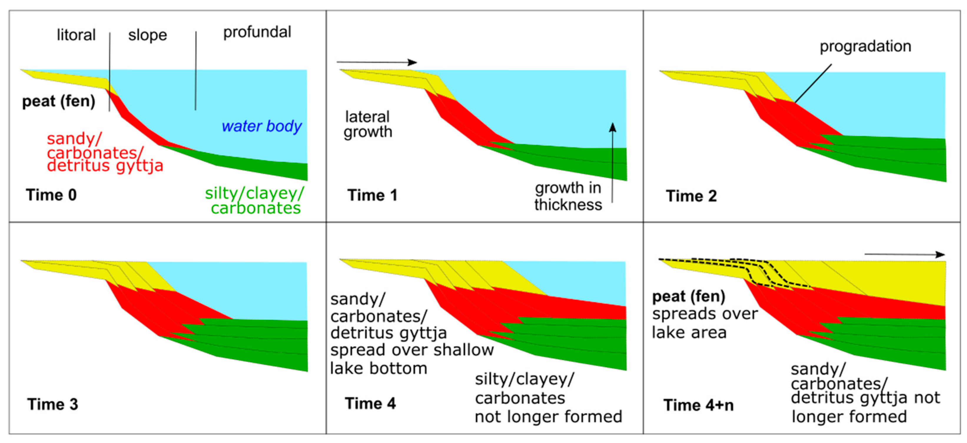
Gradual siltation of the early Holocene lake was accompanied by a general decrease in water level over time, so that by the 19th century CE, most of the basin was occupied by a fen, partly covered by raised bog.[6,16,17,23,24] suggested a model which reconstructs the lake infilling using the stratigraphy and morphology inferred from geophysical and geoarchaeological results. A modeling approach based on GPR allows for the detection of former islands and thus further potential Mesolithic occupation sites, but some limitations have to be mentioned. The reconstruction of the siltation of the lake basin and the peat overgrowth during the final phase allows for only a limited deduction of the chronology of possible settlement sites within the former lake basin if it is based solely on sediment types/facies. The same sediment types/facies usually occur laterally as a result of the shrinking of the former lake basin. Figure 2 schematically illustrates the infill of a lake basin with sediments over time. Even without marked changes to the water level, a shallow lake basin (such as the Duvesee basin) could be assumed to be filled quickly by a succession of sediment series typically formed in specific depositional environments. The latter—often defined as “sediment facies”—are mostly controlled by nutrient status and water depth of and within a lake. After crossing critical thresholds of water depth, specific sediment types might not only accumulate vertically, but also spread laterally over larger areas of the lake bottom while other sediment types are no longer formed. This is the case for peat layers (e.g., reed peat) for instance, which can start to form over large areas of the lake bottom when the water depth decreases to c. 2 m and reed covers large parts of the lake. Calcareous fine gyttja, contrariwise, does not form in shallow water depths under these conditions. Thus, while the sediment types give hints to the nutrient availability within the lake and the local water depth of deposition, additional independent age information (e.g., radiocarbon data, pollen stratigraphic data) is needed to deduce the configuration of the paleo lake landscape during a specific periods, such as the Mesolithic period. This becomes even more important if early Holocene Mesolithic contexts experienced post-depositional alteration (e.g., sediment sagging associated with delayed deep thawing of dead ice) as observed at other sites [25].

3. Methods

3.1. Ground-Penetrating Radar (GPR) Survey

GPR is a non-destructive geophysical method that uses electromagnetic waves. The system consists of a transmitting and a receiving antenna that generate and detect the electromagnetic waves, respectively. The propagation of a radar signal depends on the dielectric permittivity (εr), which controls the propagation velocity and reflection strengths, and the electrical conductivity (σ), which influences the signal attenuation.
Signal strength and center frequency of radar signals decrease during wave propagation due to energy absorption. High water content and clay sediment, for instance, strongly attenuate the radar signal and reduce the depth of investigation [26]. Penetration depth and resolution are also influenced by antenna frequency. Lower antenna frequencies are favorable for greater penetration, but result in a decrease in vertical resolution, which is defined as approximately a quarter of the GPR wavelength [26]. This means that the lower stratification can be less well resolved compared to the upper stratification. This technique is being increasingly used in peatland environments. Its applications range from determining the stratigraphy of peat [27] to defining the boundaries between peat and organic-rich lake sediment [5,6].
The table reported in [6] summarizes the large ranges of values for εr and σ in peatland environments. The interface between the peat and the underlying mineral sediment is identifiable because of the sharp reduction in the volumetric water content between the peat and the mineral soil below (e.g., [5,28]). GPR profiles within peat show reflections that match variations in peat moisture content [4,6,27,28], identifying the boundary between uppermost, poorly decomposed peat (‘‘acrotelm’’) and underlying, well-decomposed peat (‘‘catotelm’’). At some sites, high fluid electrical conductivity in peat, or a high percentage of clay in the mineral soil, can excessively attenuate radar wave propagation, reducing the depth of penetration in peat and usually preventing recording of reflections from below the mineral soil contacts underlying peat bogs [27,29]. The situation at Duvensee is favorable due to the presence of a dry-peat layer [6].
In this paper, we use the data and results of two GPR campaigns. The first was carried out in 2016 using a GSSI SIR4000 GPR unit with 200 MHz frequency antenna, covering 63 ha of the former lake (acquisition settings and processing in Table 2). The second was carried out in 2018 using a 16 channel 400 MHz MALÅ Imaging Radar Array (MIRA) with 8 cm in-line and cross-line trace spacing (acquisition settings and processing in Table 2). In both datasets, GPR reflectors were picked, combined with coring data, and compiled into a 3D model of the lake stratigraphy [16,17]. A detailed discussion of GPR resolution at Duvensee and its limitations in locating and mapping archeological features is given in [6,16,17].

3.2. Radar Facies Interpretation

According to [30,31], GPR features can be classified based on the shape, the dip, and the amplitude of the reflection. Moreover, the relationship between the reflections and their continuity is also a parameter to consider. Considering the resolution applied for GPR surveys, it is possible to interpret sedimentary facies and GPR facies associations, which are useful for the interpretation of depositional environments through the use of the reflection profile of the radar [30]. In the present study, we classified the different radar facies belonging to the island’s slope, using the measured profiles and the corings available close to the sedimentary structures.

3.3. Raster Data Calculation

Beside geophysics, we decided to incorporate some geo-spatial variables, creating a novel approach to investigate which factors influenced human occupation at ancient Lake Duvensee. Environmental factors are indeed closely related to locational decisions made by hunter–gatherers, and they play a role in patterns of settlement positions. Our approach consists of using the selected horizons of each GPR facies interface to create grids (see Section 3.1) and calculating geo-spatial parameters with GRASS GIS. From the depth-contour line data, we used the standard procedures available in GRASS GIS to generate a SLOPE (ground steepness) layer and an ASPECT layer (direction of ground facing counterclockwise from east: 90 degrees is north, 180 is west, 270 is south, and 360 is east). The slope output raster map contains slope values, stated in degrees of inclination from the horizontal. The algorithm used to determine SLOPE and ASPECT uses a 3 × 3 neighborhood around each cell in the raster elevation map. Thus, slope and aspect are not determined for cells adjacent to the edges and NULL cells in the elevation map layer. These cells are set by default to no data in output raster maps. Horn’s formula is used to find the first order derivatives in x and y directions (https://grass.osgeo.org/grass82/manuals/r.slope.aspect.html, accessed on 25 May 2023).

4. Results

4.1. Ground-Penetrating Radar (GPR) Survey

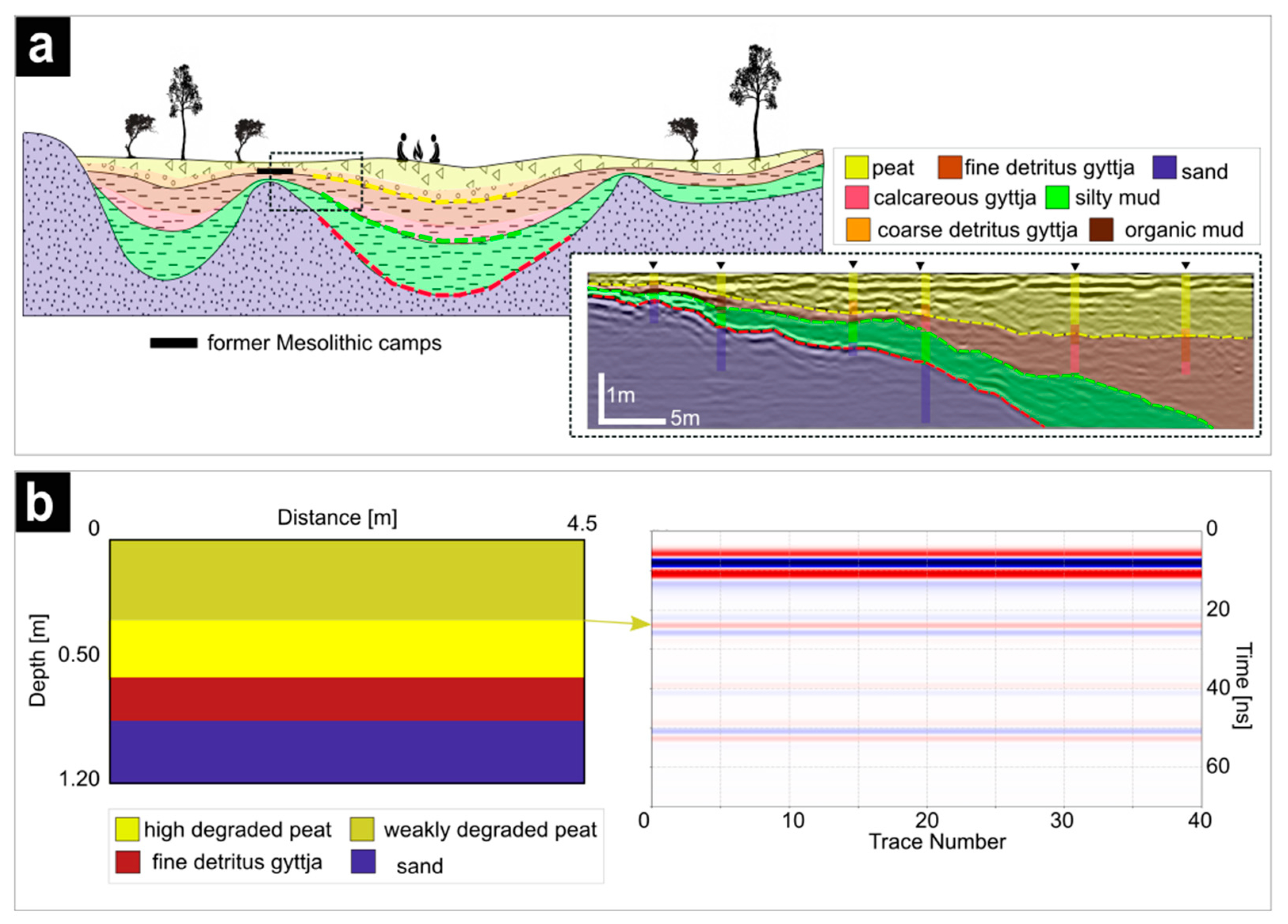
The results of the GPR surveys are used to classify different depositional facies correlated to the ancient basin evolution, in particular to the island’s slope. The analysis isolated three major GPR reflectors/interfaces which represent the transition between organic and non-organic sediments. The main units visible in the stratigraphy are peat, detritus gyttja (coarse, fine and elastic detritus gyttja), calcareous gyttja, minerogenic mud, and sand sediments. Figure 3a shows a schematic reconstruction of the silted-up lake using the dashed lines as indicators of the detected interfaces. The main reflectors visible in the GPR record are [6,16]:
  • Interface1 (yellow dashed line) represents the transition between the coarse organic sediments (peat and coarse detritus gyttja) at the surface and the underlying fine organic sediments (i.e., fine detritus gyttja, calcareous gyttja),
  • Interface2 (green dashed line) represents the transition between fine organic sediments and underlying clayish-loamy deposits in the bottom of the previous lake, and
  • Interface3 (red dashed line) marks the transition between the clayish-loamy layer and the basal sand deposits, which indicate the location of former islands.
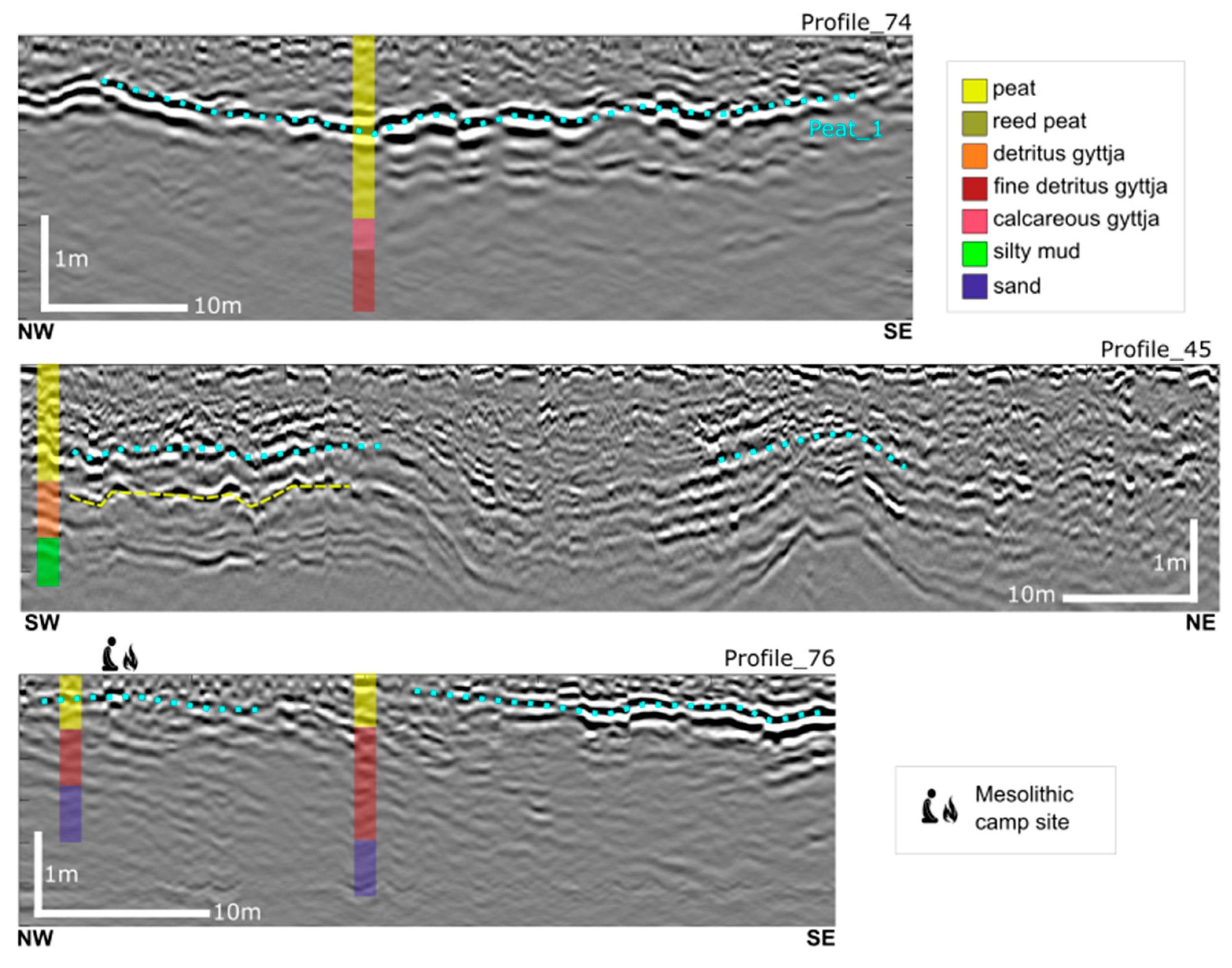
In the study by [6], the authors reported that peat internal reflectors are correlated to the degree of decomposition, which determines the physical properties of peat. The conductivity (σ) and dielectric permittivity (εr) of peat were measured in-situ and determined for both weakly and strongly degraded peat. These parameters have been used for forward modeling using gprMax, which is an open source software program that simulates electromagnetic wave propagation [33]. The resulting radargram is shown in Figure 3b and confirms the detectability of different peat conditions. The yellow arrow indicates the reflector associated with the variation in the degree of decomposition. If we focus on the GPR survey performed at Duvensee, we notice that an internal peat horizon is recurrently visible in the record. The transition between peat and gyttja is instead slightly visible, which makes its detection very challenging. Profile_74 shows a very clear horizontal reflector with high reflectivity in the middle of the peat layer (cyan dotted line in Figure 4, hereafter called Peat_1). In Profile_45, the peat layer exhibits a defined reflector following the underlying Interface1 (yellow dashed line) and locally disorganized sets of internal-reflections, which appear to be very discontinuous. Profile_76 lies in proximity to a campsite, and the internal sequence of reflections in the peat layer is almost linear, but at the other end of the profile, a strong high reflectivity sub-horizon is present. The clear pattern of this internal layering is not possible to define because on some profiles, Peat_1 follows the bottom of the peat deposition (=Interface1) but locally presents some discontinuities whose origin is not completely known. At the location of campsites, for instance, the horizon is quite flat, and its interface is linear and not always clear to follow.
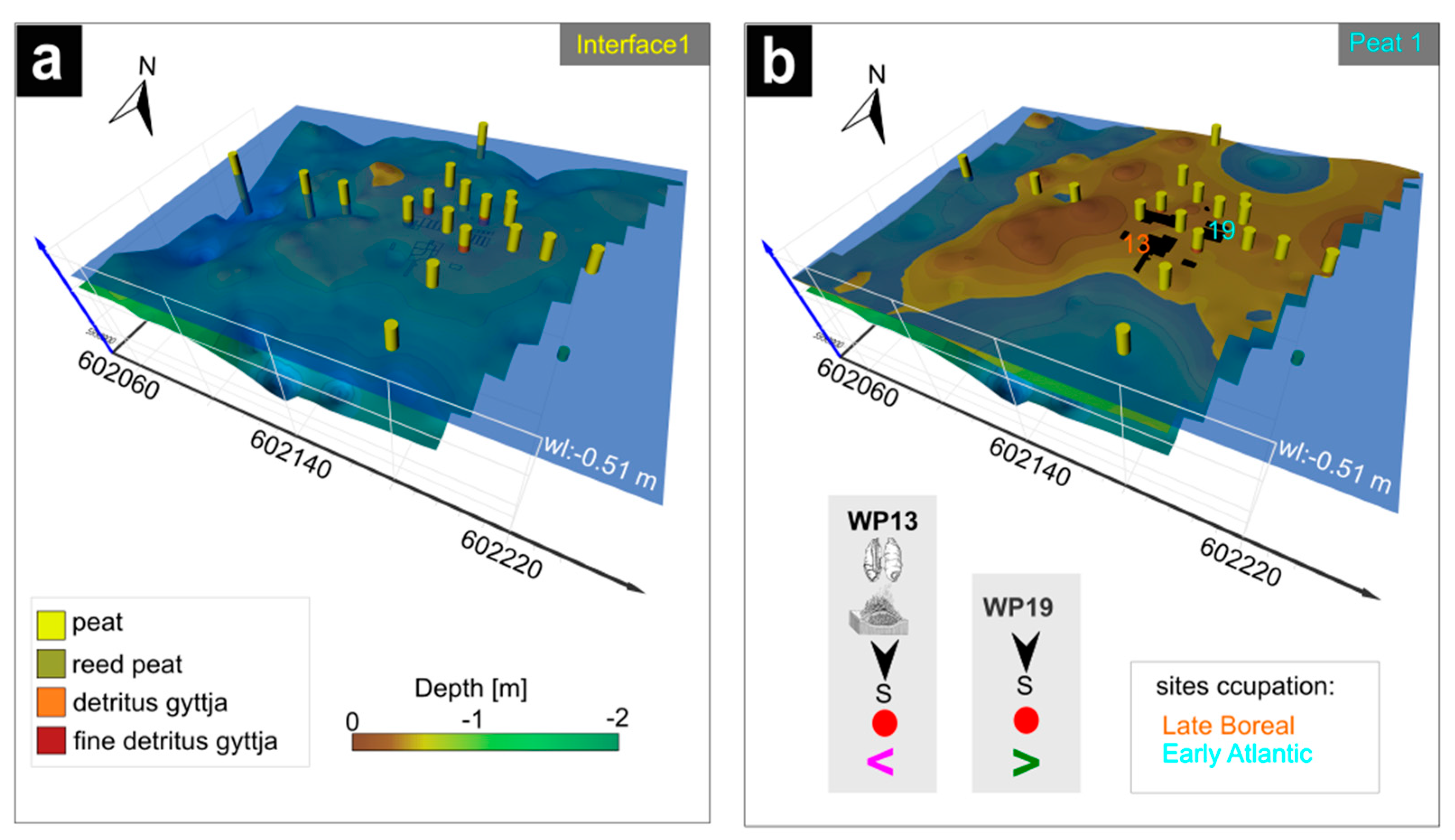
To reconcile the internal peat stratification (Peat_1) in parallel with the corings at locations WP13 and WP19 (on Island 3), we have attempted to reconstruct the stratigraphy of the site. As we know from archeological research, the Mesolithic sites are located on the peat layer. At WP13, the distribution of lithic artifacts has been utilized to reconstruct the former shoreline [34,35,36]. It transpired that everything below −0.51 m (below today’s ground surface) had been deposited underwater. Figure 5a,b shows the different interfaces with the water level at −0.51m, together with corings performed close to the dwelling sites, in a 3D view. Figure 5a showsInterface1 (bottom of the peat), which, as expected, is underwater, so no settlement occupation was possible. When examining the horizon of Peat_1 (Figure 5b), we see that the sites are on a dry area, confirming the archaeological assumption. This horizon should be therefore correlated to the changing environment and peat formation/humification.

4.2. Geomorphological Variables in Archaeological Context

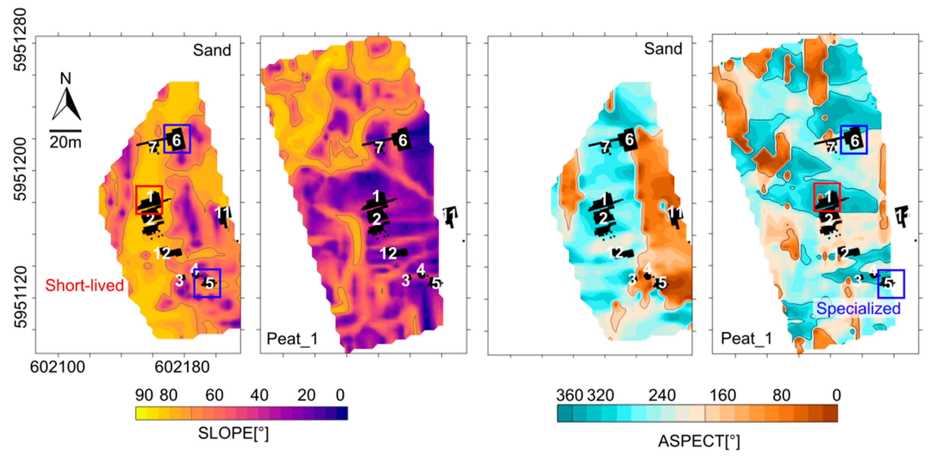
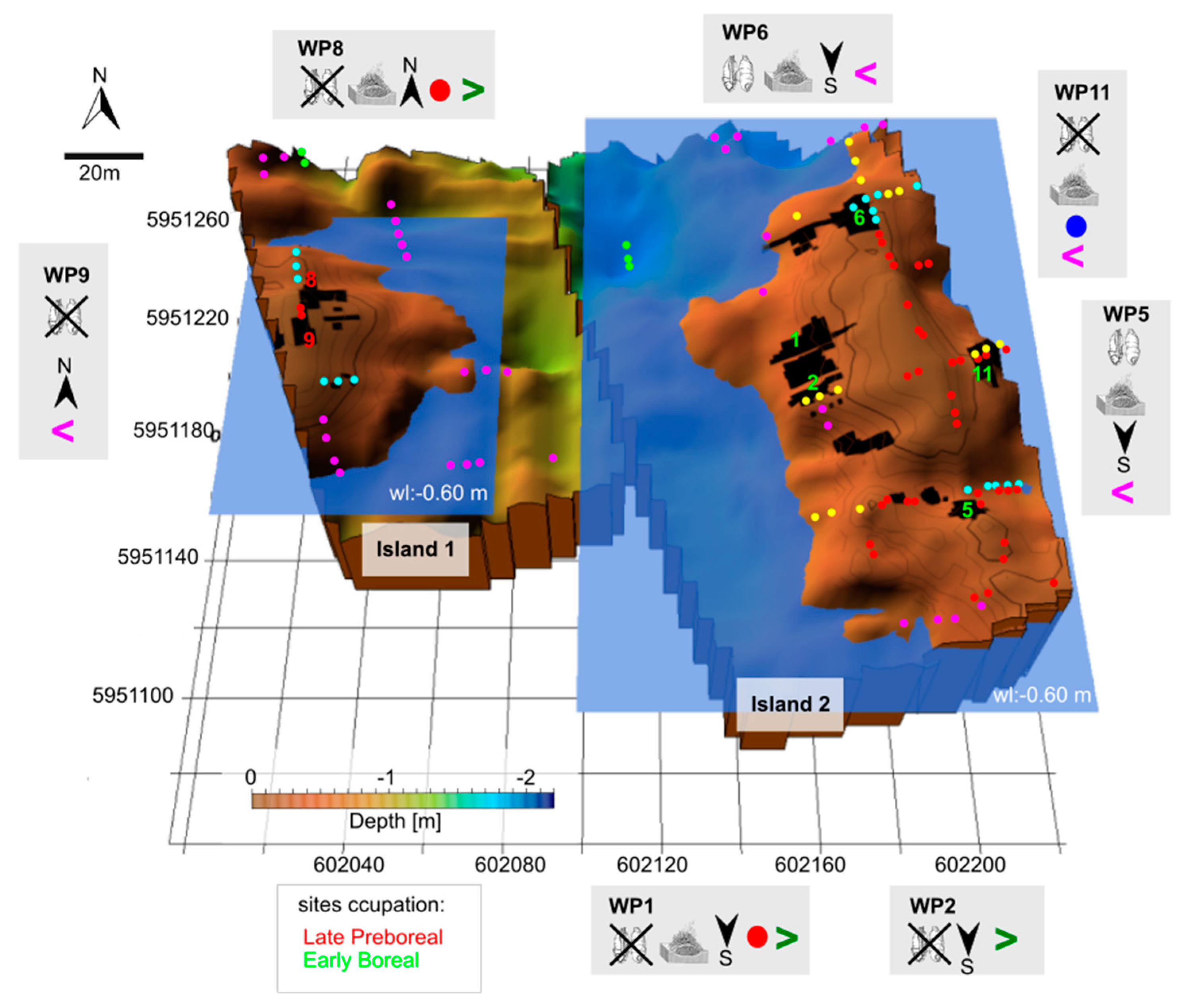
In this subsection, we present the geomorphological variables that characterize the location of the campsites in our model. Figure 6 shows the SLOPE and ASPECT values calculated considering the Sand (Interface3) and Peat_1 layers for Island 2. We considered these interfaces because the sand gives the shape of the island and Peat_1 is the layer associated with the human occupation. Regarding the Sand layer, it is interesting that the short-lived campsites are located on steeper slopes, while the specialized sites are on shallow slopes. The ASPECT instead indicates the direction that a slope faces with respect to the sun. Values between 180°–270° indicate that the slope faces south, which means that the campsite received more solar radiation compared to values between 0° and 90°,whichare more shaded. Regarding the Peat_1 layer, we notice that both specialized and short-lived sites are located on low values of the slope. Furthermore, the evaluation of these parameters indicates a change in orientation of the Mesolithic campsites. As well as Island 2, the campsites on island 3 show a southward orientation, while the oldest occupations on Island 1 and the Neolithic sites on Islands 4,5 show an orientation to the north.

4.3. Comparison between Radar Facies and Sedimentary Structures

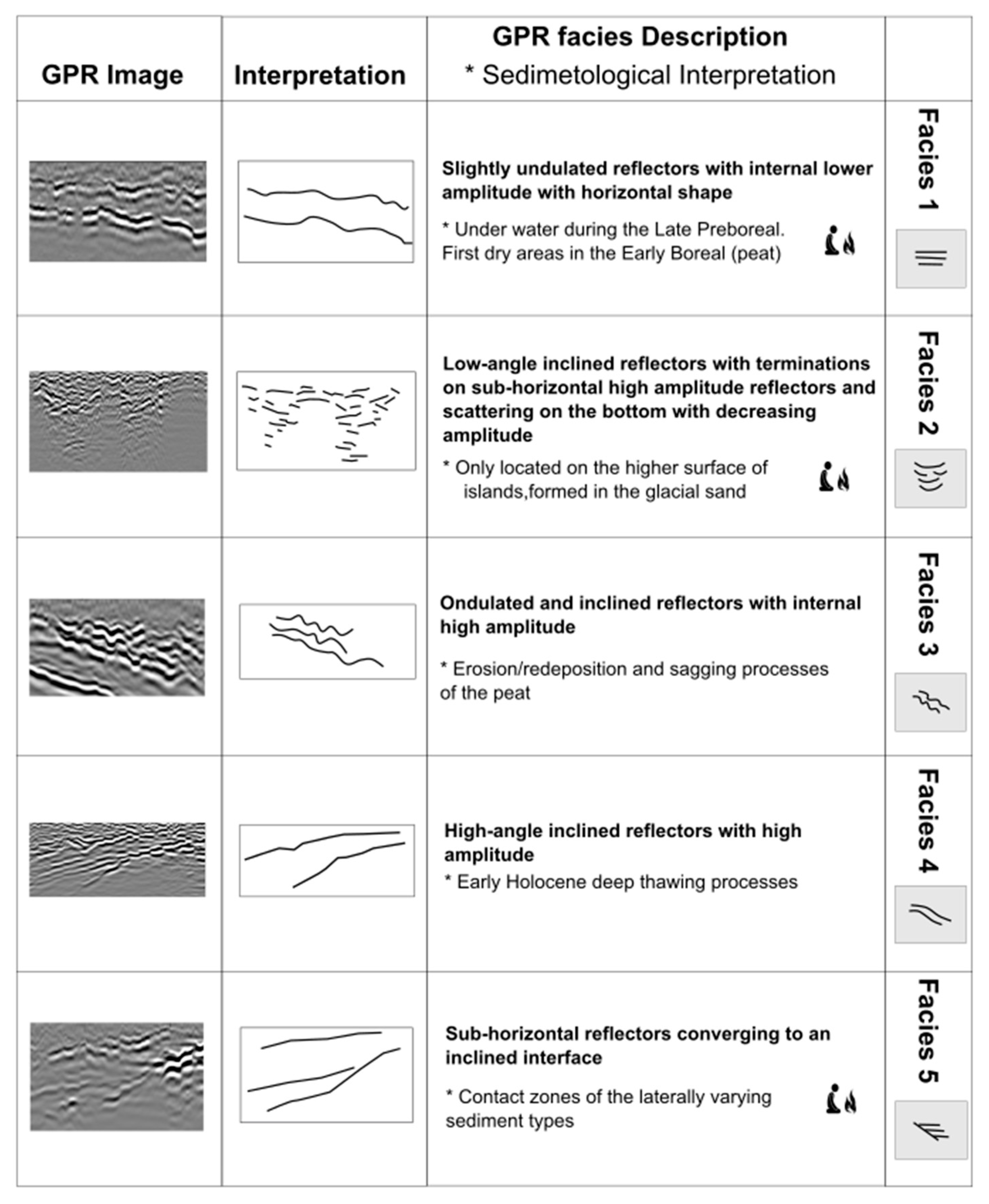
Based on the analysis of the GPR record, this study has identified five major radar facies correlated to shoreline deposition, which are summarized in Figure 7. We chose to classify only the sedimentary structures close to the islands’ shoreline because, as we said above, the Mesolithic campsites are concentrated in that location. In order to assess the reliability of the radar facies interpretations, the coring information was used for direct comparison.
1—Slightly undulated reflectors with lower internal amplitude.
Description: 1—Sets of slightly undulated reflectors with lower internal amplitude and horizontal shape (low-angle inclination). This pattern is present on all the investigated islands, and it is the closest to the shoreline and locally resembles a continuous interface. The presence of Mesolithic camps has also been recorded in its proximity. Fireplaces and hazelnut-roasting hearths have been documented close to this facies.
Interpretation: 1—This feature formed in shallow water close to the former shoreline. It became exposed by lake level lowering during the early Boreal.
2—Low-angle inclined reflectors with small scattered reflectors.
Description: 2—Sets of sub-horizontal reflectors with low-angle inclination presenting scattered reflectors with decreasing amplitude on the bottom. These interfaces bound sets of high and moderate amplitude reflectors. This pattern is present onall the investigated islands, and it is located only on top of them. The presence of Mesolithic fireplaces has also been recorded in its proximity.
Interpretation: 2—The pattern associated with this structure is only visible on the higher surface of the islands, which was mainly dry during the time of occupation. This feature has formed in the glacial sandy deposits without any relation to early Holocene lake evolution.
3—Slightly undulated reflectors with high internal amplitude.
Description: 3—Sets of slightly undulated and inclined reflectors with high amplitude. Locally, the inclination is variable. The pattern is localized mainly in the sector between Island 1 and Island 2, in the deeper part of the overgrown lake. The presence of Mesolithic camps has therefore not been recorded.
Interpretation: 3—This feature is related to the erosion/redeposition and sagging processes of the peat. While the former could be related to processes in action during Mesolithic times, the latter probably occurred during the subsequent Holocene.
4—High-angle inclined reflectors with high amplitude.
Description: 4—Sets of high amplitude reflectors with high-angle inclination. These reflectors bound sets of high and moderate amplitude reflectors. This pattern is present in all the investigated islands, and it is located at a greater distance from the shoreline; the Mesolithic camps are indeed distant from this structure.
Interpretation: 4—The steep inclination which affected the Pleistocene and the oldest parts of the early Holocene deposits are probably related to early Holocene deep thawing processes of dead ice blocks in deeper parts of the lake basin.
5—Sets of sub-horizontal reflectors converging to an inclined reflector.
Description: 5—Sets of slightly undulated reflectors with different amplitudes and low inclination that converge on a main, high, inclined interface. This pattern has not been recorded on Island 1 but on all other former islands. The presence of fireplaces and hazelnut-roasting hearths is also documented in its proximity.
Interpretation: 5—This feature represents contact zones of the typical laterally varying sediment types (characteristic for different lake depths). It has been observed close to the Mesolithic lake shores.
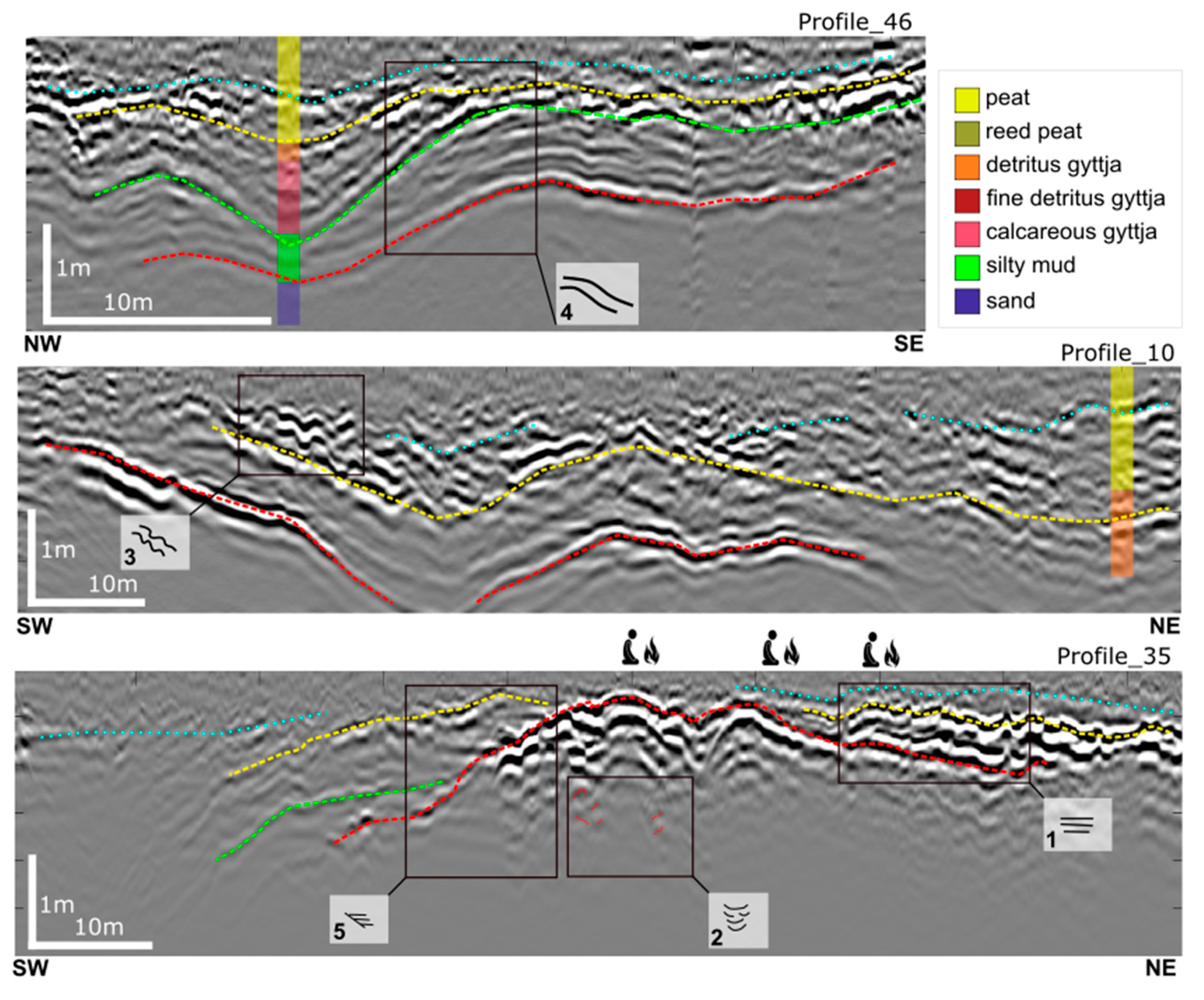
Some examples regarding the classified GPR facies are reported in Figure 8, and they are compared with the stratigraphy and the location of the Mesolithic camps. Profile_46 shows an example of radar facies 4, indicating deposition far from the former islands, while Profile_35 displays the different GPR patterns close to an island. The internal Peat_1 interface follows the peat bottom, where this interface follows the shoreline. However, different behavior have been observed, such as in Profile_10, which has the characteristics of undulated GPR feature 3, e.g., internal discontinuous layering.
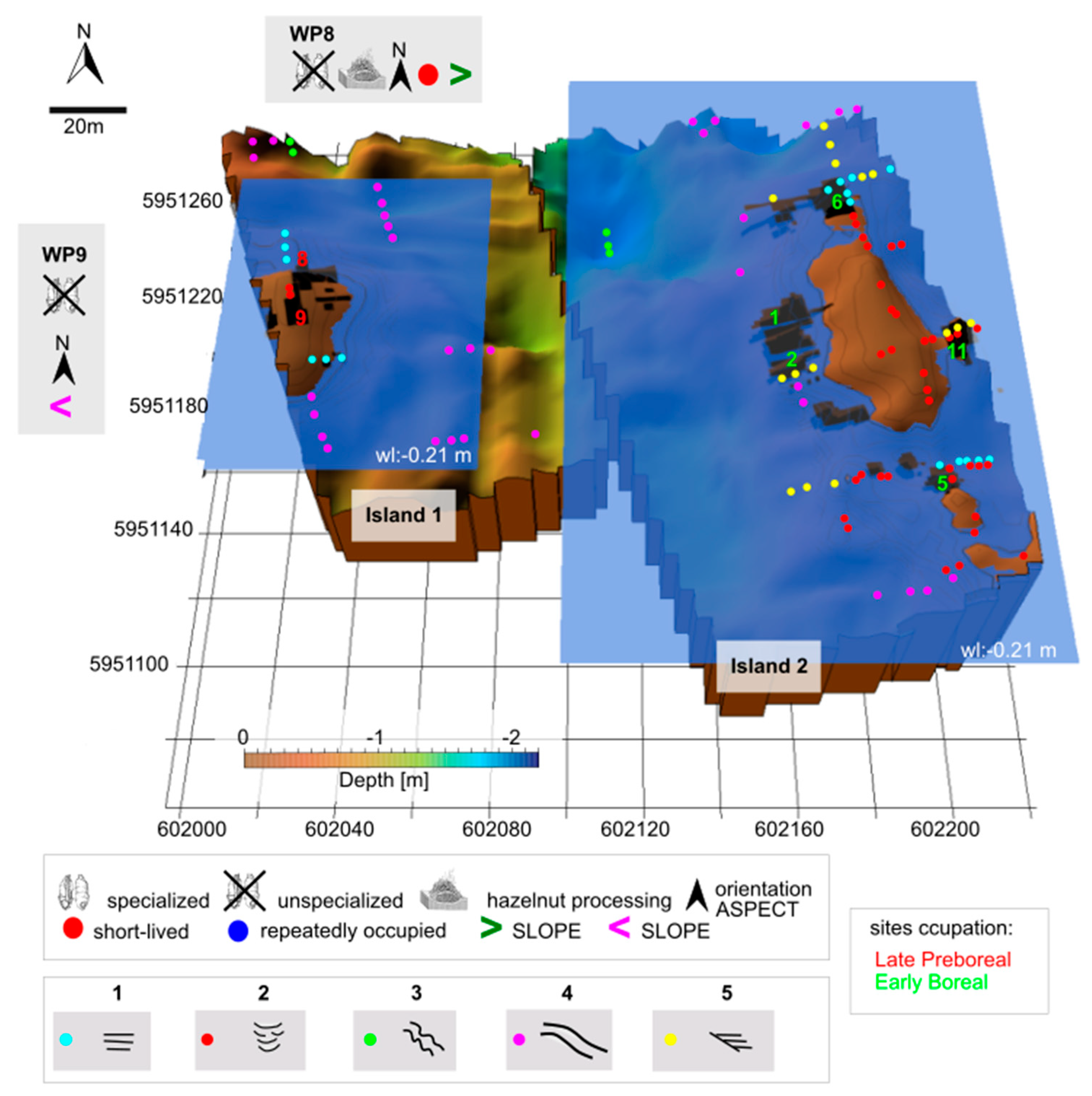
To understand the connections between the GPR and the recorded archeological findings, we present in Figure 9 the distribution of the GPR facies on Islands 1,2, and 3. WP1 is located close to facies 2 and 5 as well, as areWP2 and WP11, which yielded an excellently preserved wooden axe fitting made from root wood (Figure 9a, after [15]); a paddle made of pine wood was found in WP2, and this is early evidence for the use of watercraft to move through the landscape (Figure 9b, per [15]). WP11 is one of the most complex sites excavated at ancient Lake Duvensee, where four different hearths/roasting facilities (Figure 9c, after [14]), as well as a stratigraphic sequence of ca. 20 bark mats, have been recorded. WP5 and WP6, which are both specialized campsites, are instead close to GPR facies 1 and 2, showing at the first, a lithic artifact spectrum more specialized to domestic activities and woodworking and at the latter, microlith production [15].

4.4. Understanding the Human Occupation and Landscape Evolution as Derived from This Study

Using the presented approach, it is possible to obtain an idea of the movement of the settlements during the Mesolithic and to suggest a scenario of sedimentation evolution. In this section, we describe the early Holocene development of human ecology in the Duvensee microregion from the late Preboreal to the Subboreal. The patterns we found in this region were integrated into the 3D model presented from [16].

4.4.1. Late Preboreal

The first known human occupations at ancient Lake Duvenseedate to 11,100–10,700 cal BP and thus consequently to the Preboreal (11,560 to 10,640 cal BP). They were located on Island 1 (WP8 and WP9; for exact references to the radiocarbon dating of the different campsites, see [15]). They were unspecialized (that is, no exact function to assign; most likely only temporary camps) and both oriented to the north. Hazel (Corylus avellana)—later an important tree species both economically and ecologically—was still patchily distributed in the landscape and therefore only scarcely documented at WP8 [37]. This campsite has been recorded as a short-lived area located on a higher sand slope. During the period of the occupation, parts of the island were covered with vegetation consisting of grasses, herbs, and ferns [24,38]. In general, the regional vegetation development was characterized by a gradual change from birch- to pine-dominated woodlands. The near site sequence presented here illustrates that the lake level was lower than its maximum elevation by this time and Island 2 gradually emerged, but the locations of the corresponding camps were still under water cover. Ref. [32] reported a water level at WP8 at about 2 m away from the bark mat of the excavated camp. This level is shown in Figure 10 and represents the occupation conditions during this time. The GPR facies 1, 4, and 5 were underwater and on top of the surfaces; 2 was dry. Over the course of the Preboreal, hydrological fluctuations occurred where temporary changes from coarse to fine detritus gyttja occur at WP8 [15].

4.4.2. Early Boreal

At the beginning of the Boreal, at about 10,640 cal BP, the lowering of the water level continued as indicated by a change from fine to coarse gyttja on a profile of WP8 furthest from the shore of Island 1 [15,24]. On Island 2, five early Boreal campsites are known (WPs 1, 2, 5, 6, 11; Figure 11). WP1 and WP2 were the first unspecialized occupation of Island 2, and they are situated on a floating island [12]. WP1 is a short-lived site located on a higher island slope (Sand interface), suggesting that WP2 might have been a short-lived campsite as well. Peat formation atWP1 and WP11 did not start synchronously with that of WP6 but somewhat later, suggesting that the two sites were located on higher terraces and therefore became dry only during the course of the early Boreal [24]. A further occupation on Island 2 is documented with WP5 and WP6 (10,400–9900 cal BP), which were very significant campsites and were used during the period of higher hazel pollen percentages [14]. They were located on a shallower slope of the sand interface and are documented as specialized sites. Regarding the GPR facies, we notice that facies 1 corresponds to the first dry areas. During the early Boreal occupation, the areas carrying facies 5 became dry later than facies 1, evidenced by the Peat_1 deposition. WP11 (10,100–9900 cal BP), another significant site due to the quality and quantity of archaeological finds, was located on shallower sand slope and was repeatedly occupied. The water level during the early Boreal has been documented by [14] and is displayed here in Figure 11. The early Boreal was generally considered the period when hazel became increasingly present within the pine (Pinus sylvestris) forests. At a more local level, however, the establishment of hazel did not proceed in the same way everywhere and depended on local ecological conditions (e.g., changing waterlogging in the case of colonization of lakeshore terraces). There were indeed setbacks in the abundance and distribution of the species that depended on local factors [24].

4.4.3. Late Boreal/Early Atlantic

In the second half of the early Boreal, Island 3 emerged and was occupied several times. The water level during the time of occupation is described in Figure 5, confirming that the Peat_1 interface was completely deposited during this period, making the area suitable for occupation. Analysis of the vegetation demonstrates the expansion of reed and fern vegetation in parallel to the maximum of pine [24,39]. After this phase, a marked decrease in pine proportions, accompanied by the mass expansion of hazel, marks the transition to late Boreal. The occupation of WP13 has been documented as occurring in this period [15]. WP13 is a specialized site and located on a shallower sand interface despite the short-lived occupation. For the beginning of the Atlantic period, on-site pollen archives are largely missing. Nevertheless, potential anthropogenic indicators have been recorded from one site, and the campsiteWP19—again at Island 3—has been documented. This is a short-lived unspecialized site and therefore located on a higher sand-slope. As with the older WP13, it is oriented to the south.

4.4.4. Subboreal

The occupation of Islands 4 and 5 has been documented archaeologically fromWP15 and WP17, which are positioned on high sand slopes and are both oriented to the north. The palynological record shows that cereal cultivation and grazing activities took place in the area of Island 5, indicating fairly dry on-site conditions [24].

5. Discussion

5.1. Deposition Scenario at Ancient Lake Duvensee

Based on the GPR results and a large number of sediment cores [6,16,23,24,34,37,39,40], a generalized scenario of the nutrient availability, water level changes, and lake-filling processes of Lake Duvensee during the Early Holocene Mesolithic period can be outlined. A characteristic sequence of sediment types was deposited over the course of the Holocene in the deep lake water environment on the former lake shores. Peat was deposited throughout the Holocene. By the Younger Dryas and the Preboreal (c. 11,560 to 10,640 cal BP), detritus gyttjahad started to accumulate at greater and in particular at medium depths of the lake basin, reflecting the awakening of life within the Early Holocene lake. With the beginning of the Boreal (c. 10,640 to 9220 cal BP), algal gyttja was deposited in the deepest part of Lake Duvensee in larger amounts, indicating a further increase in bioproductivity. The following Atlantic period (c. 9220 to 5660 cal BP) saw a further spread of fine detritus gyttja and a phase of fine calcareous gyttja deposition in deeper parts of the lake. In particular, the formation of fine-grained calcareous gyttja reflects a stronger hydrological connection between the lake and its catchment. An increased supply of Ca from the groundwater flow from the surrounding catchment (related to soil formation processes under a closing forest canopy) and high bioproductivity within the lake water (algal blooms) led to the deposition of fine-grained calcareous gyttja. A stepwise increase in lake productivity over the early Holocene can be deduced from the sequence of sediments in the deeper parts of the lake. This increasing productivity should have led, during the Mesolithic, to an increasing abundance of fish in the lake, which may have acquired a growing importance as a human food resource. However, archaeological evidence for this is lacking. It is possible that a site primarily dedicated to fishing has simply not been found to date. Indications of general trends of water depth and lake filling are possible on the basis of the available sediment and pollen data as well. As described earlier, there is a long-term trend of water level lowering, starting abruptly after the Younger Dryas, and continuing over the course of the early to mid-Holocene. The former reflects the onset of the interglacial hydrological system in the lake catchment, with thawing of soils and the establishment of a groundwater repository, thus exposing the Younger Dryas lakeshore terraces that surrounded the lake basin. The latter is connected to the rising influence of the evolving vegetation cover in the catchment area. As the forest cover became denser, a larger amount of the water was consumed by the trees and transferred as water vapor out of the lake’s catchment due to increasing evapotranspiration rates. This effect of vegetation cover on the water cycle of central European catchments has been described for lakes by [41] or for soils by [42]. A number of sites in northern central Europe reflect these catchment-related lake level dynamics, e.g., during the so-called Migration period in the mid of the first millennium CE, when close forest covers developed repeatedly and prehistoric landscape openings shrank significantly (e.g., [41,43]). In the Mesolithic period, a long-term trend of water level lowering and the emergence of increasing areas of lakeshore and islands can be deduced. This long-term trend might have been modulated by small-amplitude lake level changes (a few decimeters) depending on short-term climate fluctuations (e.g.,[44,45]), thus affecting the shore area (peat deposits). During the mid- and late Holocene, lake level increases might have been associated with prehistoric and historic forest clearances and the resulting changes to the catchment’s hydrological cycle. The trend of island exposure is complicated on the microtopography level. Delayed deep thawing of dead ice, buried by late Glacial and early Holocene sediments, modified the general pattern, leaving a randomly rugged microtopography with offset and tilted layers on a local level (e.g.,[25,46]).While any unequivocal deduction of a given sedimentary environment is limited to the interpretation of sediment cores, GPR measurements offer the advantage of mapping and connecting different sediment layers over large areas. This is illustrated by the patterns of GPR facies given in Figure 7, Figure 8, Figure 10 and Figure 11. GPR facies 2 is characterized by sandy glacial outwash deposits at higher elevations not covered by lacustrine sediments, forming the cores of former islands and campsites at ancient Lake Duvensee. Facies 1 and 5 show lacustrine sediment layer configurations typical of undisturbed deposition. This might be explained by the deposition of the respective sediment sequences (a) in a water depth beneath the average wave base (moderate to greater water depth) or (b) in sheltered positions of depositional environment (e.g., shores not exposed to the main wind direction/sheltered by a reed cover). GPR facies 3 could be interpreted as reflecting sedimentary environments that were disturbed during sediment deposition. These could have occurred (a) due to exposure to the main wind direction, (b) as an effect of lake level changes, or (c) as a result of bioturbation. Small-scale fluctuations in lake level (a few decimeters) may have affected peat deposits in the shoreline area, resulting in repeated subsidence and floating cycles of the sediments. This might have occurred as a synsedimentary process (Mesolithic times) or as a result of Neolithic and in particular later prehistoric and historic forest clearances as a post-depositional process. Trampling by larger animals and Mesolithic settlers could provide another, supra-local process of sediment disturbance. GPR facies 4 is likely to reflect deep thawing processes of dead ice in the lake basin, since the related tilting and sagging of layers affected the complete lower parts of the lacustrine sediment sequences.

5.2. Use of the Islands from Archeological Perspective

As we have demonstrated, many known Stone Age sites in the Duvensee microregion were placed on small islands and were only inhabited for a limited period of time. They differ from each other in their duration of occupation and in their rather diverse or specialized uses. Rather ephemeral, perhaps single-day sites—WP13 and WP19 [35,47], had only a very limited spectrum of activities that were recognizable. Other sites, such as WP10 [48], were campsites where various domestic activities took place, hunting equipment was repaired, and game and fish were consumed. This contrasts with more elaborate stations such as WP11, where several occupation phases, overlapping bark mats, and roasting facilities for hazelnuts were excavated, indicating specialized, recurrent occupations of the same location [14]. In general, the diversity of sites at ancient Lake Duvensee underlines the diverse character of occupation (see summary in [15], 204–205) and, especially for the older sites, is evidence of a mixed economy of hunting and gathering at the same period of time in autumn. In the course of the Boreal, however, an increasing specialization of the sites, which focused on the collection and roasting of hazelnuts, is apparent. Essentially, the sites on islands at ancient Lake Duvensee differ from longer-term, repeatedly occupied locations such as Friesack 4 and 20 [18,25,49] or Hohen Viecheln [50,51], where the sites were repeatedly visited over generations and complex stratigraphies were formed. For this reason, too, it can be assumed that the sites in ancient Lake Duvensee were not located in an isolated area, but were part of a larger Mesolithic settlement system, to which multiphase, larger settlements such as Friesack or Hohen Viecheln may also have belonged. Future research will have to show whether these were located, for example, in the south of the ancient Lake Duvensee at the former outflow or further away in the river valley of the Stecknitz. In order to understand the movement of the people through the islands during the Mesolithic, the results of this study must be merged with the previous knowledge. Three of the facies correspond to Mesolithic sites and were therefore preferred by hunter–gatherers for establishing their temporary camps. Analyzing the ASPECT variable, it transpires that short-lived camps are concentrated on steeper slopes, while the repeatedly occupied sites are located on shallower values. Apparently, people intentionally used flat and sheltered areas for camps used for longer periods of time and steeper terrain for a short stay. The changing orientation of the camps through the islands raises an interesting point of discussion, namely that the quantity of solar radiation may have influenced the choice of location for a camp. However, our reconstructions of island topographies do not indicate any preference or tendency for a particular compass direction—on the contrary. Other aspects or considerations seem to have been much more decisive in the choice of location for a camp. Such considerations may have included local soil moisture, convenient access to the water, or simply a good view. The hazel exploitation at ancient Lake Duvensee may be of peculiar importance, which might have influenced human occupation. Some of the campsites in the microregion have become widely known for their intensive use of hazelnuts, which were made more digestible with special roasting equipment [14,52,53]. The general importance of collecting and consuming hazelnuts in the subsistence system of Mesolithic people is, however, difficult to assess [14,54] and may also have been subject to temporal changes. On the islands themselves, hazel certainly grew only on relatively dry areas, because it does not tolerate inundation. This assumption raises a question: why should people have gone to the islands to collect hazelnuts, when hazel also grew around the lake? It is conceivable that the hazel trees and bushes on the islands in Lake Duvensee, which were quite well protected from animals, were deliberately cultivated in order to improve the nut harvest. Such care would already be suppressing other trees, because hazel has a much higher nut yield in the sun rather than in the shade. Large amounts of micro-charcoal together with plant disturbance and erosion indicators, as demonstrated on other islands in lakes of eastern Schleswig-Holstein in Mesolithic stratigraphies [55,56], could be the result of such cultivation. Thinning that that allowed light back into the interior of the crown was also important for high yield and was easy to perform. Other explanations point in the opposite direction, that the maintenance of hazel on the islands is thought to have served to produce numerous tasty young shoots to attract hunting prey [55,56,57]. However, since remains of roe deer, red deer, or elk were largely absent from the archaeological sites in the Duvensee microregion, but hazelnuts were collected and consumed in large quantities instead, this latter explanation seems less plausible.

5.3. Preliminary Insight on Supraregional and Cross-Temporal Comparisons

In this paper, we presented the results of interdisciplinary work based on GPR, geoarchaeological, and geographical data to trace stratigraphic and settlement patterns, which might be connected to the adaptation or migration of hunter–gatherers at ancient Lake Duvensee. The new approach consists of mapping stratigraphic patterns or facies in the GPR record and connecting them to the landscape evolution and Mesolithic campsites locations. Our results are only associated with the Duvensee landscape but may serve as a guideline or starting point for other microregions. In this regard, a comparison with the newly investigated site of Lüchow LA 11 is our first example. This site is located on the southwestern edge of the ancient Duvensee shoreline (Figure 1) and evinces a stratigraphical pattern similar to GPR facies 5 of the presented study (Figure 12a). The archaeological research on this site is ongoing; therefore we aim only at enlarging our point of view because Lüchow has the potential to open new hypothesis for campsites location, meaning that hunter–gatherers chose the main shore of the lake and not islands. It is therefore likely that certain coastal locations really were preferred, no matter if they were islands or shore. In this regard, GPR facies 5 would play a central role, and this aspect will be the focus of future research. In the frame of the CRC 1266 “scales of transformation” from Kiel University, we investigated the archaeological site at Dümmer in northwestern Germany. This region is characterized by extensive wetlands on the southern border of the Northern Lowland and has been the subject of several research projects on Mesolithic and Neolithic sites since the last century. In 2020, new research was carried out at this site, which, through the integration of archaeology, geophysics, and palynology, reconstructed the surrounding landscape [58].Lake Dümmer probably formed as a thermokarst lake at the end of the last ice age. The formation of an outlet, i.e., the northern part of the river Hunte, over the course of the Boreal and Atlantic period, led to a lowering of the lake level and siltation of large parts of the lake basin [59].The bog area is divided into several sub-areas which merge into one another, with Lake Dümmer in the middle [60]. Several sites are known along the lakeshore, ranging from the late Palaeolithic to the Bronze Age and possibly into the Iron Age and early Middle Ages. The prehistoric sites are found at different distances from the present day lakeshore. Figure 12b shows the contour map and its 3D representation associated with the sand interface, highlighting a more elevated area in which the presence of archaeological sites is recorded. The Mesolithic occupation is located at the edge of the reconstructed former island, but no GPR facies similar to those presented in this study are visible on the dataset. However, the relatively steep slope of the terrain on the western site may not correspond to the prehistoric conditions, but may have been caused later by the modern Hunte canal. The similarity to Duvensee is evident regarding the location of Mesolithic occupation, but the depositional environments deliver different GPR patterns and therefore other relevant conditions that influenced human behavior have to be investigated in the future.
The interpretation of radar facies from GPR data is frequently used in the interpretation of sedimentary structures in fluvial deposits [31] and coastal depositional environments [62,63,64], but seldom for ancient environments. Ref. [65] presents typical examples of radar patterns for almost all the sedimentary environments in the Netherlands which are suitable for GPR measurements, creating an atlas with the inferred reflection patterns, including glacial environment. GPR facies 1 of this study, correlates well with lacustrine environments showing subparallel, continuous reflections produced by peat. GPR facies 4 and 5 seem to find a correlation as well with the glacio-lacustrine atlas ([65],Table 1),showing parallel stratified sequences and parallel-to-divergent reflections which are present along the edges of the former lake. Ref. [66] presents GPR patterning in a peatland environment in which we can compare facies 2 of our study with facies 1. This feature is characterized by wavy chaotic reflections, probably due to isolated coarse materials, e.g., boulders on the proximal portion of an esker. This observation could match our classification, in which we suppose that facies 2 is caused by sandy sediments belonging to the former island and locally a variation of granulometry may affect the GPR signature. The GPR Facies 3 does not have a significant comparison with other patterns in the literature, making this feature new for further atlas classification.

6. Conclusions

To enlarge the research at ancient Lake Duvensee, we proposed an interdisciplinary approach to tracing spatial patterns of past human activity based on geophysical, geographical, and (geo-)archaeological data. Archaeological data are good examples of datasets with many types of uncertainties, and the uncertainty is not evenly distributed over the geographical extent. Therefore, we propose a new approach merging geophysical and geographical data to fill this gap and to understand why people used preferred areas, in particular former islands at ancient Lake Duvensee.
We presented stratigraphic patterns which are visible at the Duvensee bog and how we used them to reconstruct the evolution of the lake filling. Moreover, these features were connected with human occupation to understand if stratigraphic setups influenced human occupation. We recognized five major GPR facies which have been classified and correlated to glacio-lacustrine environments. Regarding the aims exposed in the introduction we came to the following conclusions:
  • We identified three shoreline radar facies (from the five presented) in proximity to Mesolithic camps which were consecutively occupied after becoming dry during the evolution of the lake filling:
    GPR facies 1 and 2 are located mainly on top of former islands and are connected to the specialized sites where the shoreline slope is shallower. This information leads to the assumption that the sites with these conditions have the probability to be repeatedly-occupied camps;
    GPR facies 5 is characterized by a steeper slope and in proximity to unspecialized camps, suggesting that these sites are most probably short-lived camps.
  • An internal peat stratification (Peat_1) has been detected and identified via the GPR record, delivering an improved model for the basin reconstruction that fits with archeological knowledge, but no internal stratigraphical patterns have been recognized.
  • In the new models, we saw for the first time what facies were underwater and at what time, meaning that our understanding of the lake filling evolution becomes more reconstructable.
The archeological conclusions that can be summarized are the following:
  • Mesolithic hunter–gatherers and Neolithic groups preferred dry areas with access to open water for short-lived campsites and flatter and more protected areas for specialized and repeatedly occupied campsites. The cardinal orientation of a campsite seems to be secondary to the local peat over-growing process and access to water.
Important considerations have to be made at this point: the geophysical investigation integrated on a multidisciplinary approach, as we proposed in this paper, has the potential to fill the gaps that archeology presents regarding spatial distribution of artifacts or ephemeral traces of human occupation. The updated models of each island match archeological knowledge so far, and the GPR resolution fits well on this interpretation, allowing for a detailed data visualization that can help the different disciplines to understand landscape development and human adaptation in different areas. Moreover, adding more features to the so-far published atlas would help both inexperienced and experienced interpreters of GPR data to identify characteristic reflection patterns and to translate that information into radar stratigraphy for geological, even geo-archaeological applications. Such a comprehensive database is vital because similar reflection patterns may exist in several sedimentary environments; recognizing groups of distinct reflection patterns in a section will enhance a proper identification of the depositional environments involved. Borehole data should complement the radar facies atlas, especially when lithologic units from different depositional environments produce similar-looking reflection patterns.

Author Contributions

E.C. was responsible for the conceptualization of the study, analysis/interpretation of the data, and writing the manuscript; S.D.: helped the conceptualization of the study and wrote part of the discussion and revised the paper; H.L., U.S., D.W., T.W. and W.R. were responsible for funding acquisition, project supervision, and manuscript revision; M.W.-L. and J.P.B. were responsible for manuscript revision. All authors have read and agreed to the published version of the manuscript.

Funding

This research is part of the Collaborative Research Center 1266 funded by the Deutsche Forschungsgemeinschaft (DFG, German Research Foundation-grant 290391021-SFB 1266).

Institutional Review Board Statement

All procedures performed in studies involving human participants were in accordance with the ethical standards of the institutional and/or national research committee and with the 1964 Helsinki declaration and its later amendments or comparable ethical standards.

Informed Consent Statement

Informed consent was obtained from all individual participants included in the study.

Data Availability Statement

Data is available upon request from the corresponding author.

Acknowledgments

We would like to thank the longtime excavator and researcher of the Duvensee bog sites, Klaus Bokelmann, for detailed information. Furthermore, we thank the three reviewers for their valuable comments for improving the manuscript.

Conflicts of Interest

The authors declare no conflict of interest.

References

  1. Van de Noort, R.; O’Sullivan, A. Rethinking Wetland Archaeology; Gerald Duckworth and Co., Ltd: London, UK, 2006. [Google Scholar]
  2. Menotti, F. Wetland Archaeology and Beyond: Theory and Practice; Oxford University Press: Oxford, UK, 2012. [Google Scholar]
  3. Seng, E.; Schlichtherle, H.; Wolf, C.; Sommer, C.S. Prähistorische Pfahlbauten im Alpenraum. Erschließung und Vermittlung eines Welterbes. Reflexe der Immateriellen und Materiellen Kultur 3; De Gruyter: Berlin/Boston, Germany, 2019. [Google Scholar] [CrossRef]
  4. Warner, B.G.; Nobes, D.C.; Theimer, B.D. An application of ground penetrating radar to peat stratigraphy of Ellice Swamp, southwestern Ontario. Can. J. Earth Sci. 1990, 27, 932–938. [Google Scholar] [CrossRef]
  5. Slater, L.; Reeve, A. Understanding peatland hydrology and stratigraphy using integrated electrical geophysics. Geophysics 2002, 67, 365–378. [Google Scholar] [CrossRef] [Green Version]
  6. Corradini, E.; Dreibrodt, S.; Erkul, E.; Groẞ, D.; Lübke, H.; Panning, D.; Pickartz, N.; Thorwart, M.; Vött, A.; Willershäuser, T.; et al. Understanding Wetlands Stratigraphy: Geophysics and Soil Parameters for Investigating Ancient Basin Development at Lake Duvensee. Geosciences 2020, 10, 314. [Google Scholar] [CrossRef]
  7. Pereira, D.; Dias, E.; Ponte, M. Investigating the internal structure of four Azorean Sphagnum bogs using ground-penetrating radar. Mires Peat 2017, 19, 1–19. [Google Scholar] [CrossRef]
  8. Van Bellen, S.; Dallaire, P.L.; Garneau, M.; Bergeron, Y. Quantifying spatial and temporal Holocene carbon accumulation in ombrotrophic peatlands of the Eastmain region, Quebec, Canada. Global Biogeochem. Cycles 2011, 25, GB2016. [Google Scholar] [CrossRef]
  9. Korhola, A. Initiation of a sloping mire complex in southwestern Finland: Autogenic versus allogenic controls. Ecoscience 1996, 3, 216–222. [Google Scholar] [CrossRef]
  10. Schwantes, G.; Gripp, K.; Beyle, M. Der frühneolithische Wohnplatz von Duvensee. Praehist. Z. 1925, 16, 173–177. [Google Scholar]
  11. Schwabedissen, H. Grabungen auf dem Moorwohnplatz von Duvensee. Germania 1951, 29, 208. [Google Scholar]
  12. Bokelmann, K. Duvensee, ein Wohnplatz des Mesolithikums in Schleswig-Holstein, und die Duvenseegruppe. Offa 1971, 28, 5–26. [Google Scholar]
  13. Holst, D. Hazelnut economy of early Holocene Hunter–Gatherers: A case study from Mesolithic Duvensee, Northern Germany. J. Archaeol. Sci. 2010, 37, 2871–2880. [Google Scholar] [CrossRef]
  14. Bokelmann, K. Spade paddling on a Mesolithic lake—Remarks on Preboreal and Boreal sites from Duvensee (Northern Germany). In A Mind Set on Flint; Studies in Honour of Dick Stapert; Niekus, M.J.L.T., Barton, R.N.E., Street, M., Eds.; Groningen Archaeological Studies: Groningen, The Netherlands, 2012; pp. 369–380. [Google Scholar]
  15. Groß, D.; Lübke, H.; Schmölcke, U.; Zanon, M. Early Mesolithic activities at ancient Lake Duvensee, northern Germany. Holocene 2018, 29, 197–208. [Google Scholar] [CrossRef]
  16. Corradini, E.; Wilken, D.; Zanon, M.; Groß, D.; Lübke, H.; Panning, D.; Dörfler, W.; Rusch, K.; Mecking, R.; Erkul, E.; et al. Reconstructing the palaeoenvironment at the early Mesolithic site of Lake Duvensee: Ground-penetrating radar and geoarchaeology for 3D facies mapping. Holocene 2020, 30, 820–833. [Google Scholar] [CrossRef]
  17. Corradini, E.; Groß, D.; Wunderlich, T.; Lübke, H.; Wilken, D.; Erkul, E.; Schmölcke, U.; Rabbel, W. Finding Mesolithic Sites: A Multichannel Ground-Penetrating Radar (GPR) Investigation at the Ancient Lake Duvensee. Remote Sens. 2022, 14, 781. [Google Scholar] [CrossRef]
  18. Gramsch, B. Friesack: Letzte Jäger und Sammler in Brandenburg. Jahrb. Des Römisch-Ger. Zentralmuseums Mainz 2002, 47, 51–96. [Google Scholar]
  19. Jochim, M.A. Henauhof-Nordwest—Ein mittelsteinzeitlicher Lagerplatz am Federsee. In Materialhefte zur Vor- und Frühgeschichte in Baden-Württemberg, Heft 19; Theiss Verlag: Stuttgart, Germany, 1993. [Google Scholar]
  20. Kind, C.-J. Die letzten Wildbeuter. In Henauhof Nord II und das Ende Mesolithikum in Baden-Württemberg; Materialhefte zur Archäologie in Baden-Württemberg 39; Theiss Verlag: Stuttgart, Germany, 1997. [Google Scholar]
  21. Andersen, K. Stenalderbebyggelsen i den Vestsjællandske Åmose; Fredningsstyrelsen: København, Denmark, 1983. [Google Scholar]
  22. Schwantes, G. Die Vorgeschichte Schleswig-Holsteins (Stein- und Bronzezeit); Wachholtz: Neumünster, Germany, 1939. [Google Scholar]
  23. Averdieck, F.-R. Palynological investigations in sediments of ancient lake Duvensee, Schleswig-Holstein (North Germany). Hydrobiologia 1986, 143, 407–410. [Google Scholar] [CrossRef]
  24. Wieckowska-Lüth, M.; Dörfler, W. Duvensee palaeo-data in new light: Re-evaluation of on- and near-site sediment sequences from the Mesolithic and beyond. Offa 2023, in press.
  25. Groß, D.; Lübke, H.; Meadows, J.; Jantzen, D.; Dreibrodt, S. Re-evaluation of the site Hohen Viecheln 1. In Working at the Sharp End: From Bone and Antler to Early Mesolithic Life in Northern Europe; Groß, D., Lübke, H., Meadows, J., Jantzen, D., Eds.; Untersuchungen und Materialien zur Steinzeit in Schleswig-Holstein und im Ostseeraum, Band 10; Wachholtz: Kiel/Hamburg, Germany, 2020; pp. 15–112. [Google Scholar]
  26. Davis, J.L.; Annan, A.P. Ground-penetrating radar for high-resolution mapping of soil and rock stratigraphy. Geophys. Prospect. 1989, 37, 531–551. [Google Scholar] [CrossRef]
  27. Theimer, B.D.; Nobes, D.C.; Warner, B.G. A study of the geoelectrical properties of peatlands and their influence on ground-penetrating radar surveying. Geophys. Prospect. 1994, 42, 179–209. [Google Scholar] [CrossRef]
  28. Kettridge, N.; Comas, X.; Baird, A.; Slater, L.; Strack, M.; Thompson, D.; Jol, H.; Binley, A. Ecohydrologically important subsurface structures in peatlands revealed by ground-penetrating radar and complex conductivity surveys. J. Geophys. Res. 2008, 113, 1–15. [Google Scholar] [CrossRef] [Green Version]
  29. Comas, X.; Slater, L.; Reeve, A. Stratigraphic controls on pool formation in a domed bog inferred from ground penetrating radar (GPR). J. Hydrol. 2005, 315, 40–51. [Google Scholar] [CrossRef]
  30. Neal, A. Ground-penetrating radar and its use in sedimentology: Principles, problems and progress. Earth-Surf. Process. Land. 2004, 27, 261–330. [Google Scholar] [CrossRef]
  31. Gawthorpe, R.L.; Collier, R.E.; Alexandre, J.; Bridge, J.S.; Leeder, M.R. Ground penetrating radar: Application to sandbody geometry and heterogeneity studies. In Characterization of Fluvial and Aeolian Reservoirs; North, C.P., Prosser, D.J., Eds.; Geological Society Special Publication: London, UK, 1993; Volume 73, pp. 21–432. [Google Scholar]
  32. Bokelmann, K. Duvensee, Wohnplatz 9: Ein präboreal- zeitlicher Lagerplatz in Schleswig-Holstein. Offa 1991, 48, 75–114. [Google Scholar]
  33. Warren, C.; Giannopoulos, A.; Giannakis, I. gprMax: Open source software to simulate electromagnetic wave propagation for Ground Penetrating Radar. Comput. Phys. Commun. 2016, 209, 163–170. [Google Scholar] [CrossRef] [Green Version]
  34. Bokelmann, K.; Averdieck, F.-R. and Willkomm. H. Duvensee, Wohnplatz 13. Offa 1985, 42, 13–33. [Google Scholar]
  35. Bokelmann, K. Rast unter Bäumen.Ein ephemerer mesolithischer Lagerplatz aus dem Duvenseer Moor. Offa 1986, 43, 149–163. [Google Scholar]
  36. Hausmann, N. Duvensee 13—A Reevaluation: A Technological and Spatial Analysis of the Lithic Assemblage of Duvensee 13; Y8419769 Mesolithic Studies; University of York: New York, NY, USA, 2012. [Google Scholar]
  37. Bokelmann, K. Eine neue borealzeitliche Fundstelle in Schleswig-Holstein. Kölner Jahrb. Für Vor-Und Frühgeschichte Berl. 1981, 15, 181–188. [Google Scholar]
  38. Averdieck, F.-R. Palynologischer Beitrag zur Entwicklungsgeschichte des Grossen Plöner Sees und der Vegetation seiner Umgebung. Arch. Hydrobiol. 1978, 83, 1–46. [Google Scholar]
  39. Averdieck, F.-R. Pollenanalytische Untersuchungen zum Wohnplatz 13 aus dem Duvenseer Moor. Offa 1986, 43, 165–169. [Google Scholar]
  40. Schütrumpf, R. Der pollenanalytische Nachweis einer ‘schwimmenden Insel’ und die Anzahl der Siedlungsphasen am mittelsteinzeitlichen Fundplatz Duvensee. In Kölner Jahrbuch Für Vor-Und Frühgeschichte; Kr. Herzogtum Lauenburg: Schleswig-Holstein, Germany, 1981; Volume 15, pp. 161–180. [Google Scholar]
  41. Theuerkauf, M.; Blume, T.; Brauer, A.; Dräger, N.; Feldens, P.; Kaiser, K.; Kappler, C.; Kästner, F.; Lorenz, S.; Schmidt, J.-P.; et al. Holocene lake-level evolution of Lake Tiefer See, NE Germany, caused by climate and land cover changes. Boreas 2021, 51, 299–316. [Google Scholar] [CrossRef]
  42. Bork, H.-R.; Bork, H.; Dalchow, C.; Faust, B.; Piorr, H.-P.; Schatz, T. Landschaftsentwicklung in Mitteleuropa; Klett-Perthes: Gotha, Germany, 1998. [Google Scholar]
  43. Dreibrodt, S.; Wiethold, J. Lake Belau and its catchment (northern Germany): A key archive of environmental history in northern central Europe since the onset of agriculture. Holocene 2015, 25, 296–332. [Google Scholar] [CrossRef]
  44. Dreibrodt, S.; Lomax, J.; Nelle, O.; Lubos, C.; Fischer, P.; Mitusov, A.; Reiss, S.; Radtke, U.; Grootes, P.M.; Bork, H.R. Are mid Latitude slope deposits sensitive to climatic oscillations?—Implications from an Early Holocene sequence of slope deposits and buried soils from Eastern Germany. Geomorphology 2010, 122, 351–369. [Google Scholar] [CrossRef]
  45. Zanon, M.; Feeser, I.; Dreibrodt, S.; Schwark, L.; van den Bogaard, C.; Dörfler, W. Exploring short-term ecosystem dynamics in connection with the Early Holocene Saksunarvatn Ash fallout over continental Europe. Quater Sci. Rev. 2021, 253, 106772. [Google Scholar] [CrossRef]
  46. Kaiser, K. The hydrological development of Mecklenburgian lakes in the late Quaternary, Petermanns. Geogr. Mitteilungen 1996, 140, 323–342. [Google Scholar]
  47. Bokelmann, K. Eine mesolithische Kiefernrindenmatte aus dem Duvenseer Moor. Offa 1989, 46, 17–22. [Google Scholar]
  48. Groß, D.; Henke, I.S.; Lübke, H.; Meadows, J.; Schmölcke, U. Duvensee WP 10—An early Mesolithic site at ancient Lake Duvensee, Germany. J. Wetl. Archaeol. 2021. [Google Scholar] [CrossRef]
  49. Schmölcke, U. Die Säugetierfunde vom präboreal- und borealzeitlichen Fundplatz Friesack 4 in Brandenburg. In Subsistenz und Umwelt der Feuchtbodenstation Friesack 4 im Havelland. Ergebnisse der naturwissenschaftlichen Untersuchungen; Benecke, N., Gramsch, B., Jahns, S., Eds.; Brandenburgisches Landesamt für Denkmalpflege und Archäologisches Landesmuseum: Wünsdorf, Germany, 2016; pp. 45–116. [Google Scholar]
  50. Groß, D.; Piezonka, H.; Corradini, E.; Schmölcke, U.; Zanon, M.; Dörfler, W.; Dreibrodt, S.; Feeser, I.; Krüger, S.; Lübke, H.; et al. Adaptations and transformations of hunter-gatherers in forest environments: New archaeological and anthropological insights. Holocene 2019, 29, 1531–1544. [Google Scholar] [CrossRef] [Green Version]
  51. Schuldt, E. Hohen Viecheln: Ein Mittelsteinzeitlicher Wohnplatz in Mecklenburg; Akademie-Verlag: Berlin, Germany, 1961. [Google Scholar]
  52. Lage, W. Experimental archaeological exploration of Mesolithic techniques for hazelnut roasting. Schriften Des Naturwissenschaftlichen Ver. Für Schleswig-Holst. 2011, 73, 12–22. [Google Scholar]
  53. Lage, W. Experimentalarchäologische Untersuchungen zu mesolithischen Techniken der Haselnussröstung. Exp. Archäol. Eur. Bilanz 2012, 22–32. [Google Scholar]
  54. Leesch, D.; Fabre, M.; Schoch, W.H. Les Occupations Mésolithiques des abris sous-roche de Berdorf-Kalekapp 2 (Grand Duché de Luxembourg); Centre National de Recherche Archéologique: Luxembourg, Germany, 2017. [Google Scholar]
  55. Wieckowska, M.; Dörfler, W.; Kirleis, W. Holocene history of environment and human impact on two islands in the Ostholstein lakeland area, Northern Germany. Veget Hist. Archaeobot 2012, 21, 303–320. [Google Scholar] [CrossRef]
  56. Wieckowska-Lüth, M.; Dörfler, W.; Kirleis, W. Lake level change and its influence on human settlement on islands in the Holstein Lake District, Schleswig-Holstein. Offa 2014, 67–68, 27–49. [Google Scholar]
  57. Gumiński, W.; Michniewicz, M. Forest and mobility. A case from the fishing camp site Dudka, Masuria, north-eastern Poland. In Mesolithic on the Move; Larsson, L., Ed.; Oxbow Books: Oxford, UK, 2003; pp. 110–127. [Google Scholar]
  58. Brozio, J.; Feeser, I.; Heumüller, M.; Müller, J.; Corradini, E.; Kirleis, W.; Dörfler, W.; Erkul, E.; Wunderlich, T. Hunte 4: Re-validation of a Bell Beaker domestic site in the Dümmer region in northwestern Germany. Praehist. Z. 2022. [Google Scholar] [CrossRef]
  59. Dahms, E. Limnogeologische Untersuchungen im Dümmer-Becken im Hinblick auf seine Bedeutung als Natur- und Landschaftsschutzgebiet. Geol. Unters. Nieders Binnenseen 1972, 29. [Google Scholar]
  60. Schneekloth Schneider, S. Die Moore in Niedersachsen. 3. Teil. Bereich des Blattes Bielefeld der Geologischen Karte der Bundesrepublik Deutschland (1:200 000). Forschungen zur Landes- und Volkskunde 1. Veröffentlichungen Des Niedersächsischen Inst. für Landeskd. und Landesentwickl. Der Univ. Göttingen = Schriften der Wirtsch. Ges. Zum Stud. Niedersachs. e.V. N.F. 1972, 96, 1–96. [Google Scholar]
  61. Wunderlich, T. MultichannelGPR: A New MATLAB-Tool for the processing of GPR Data. Archeosci. Rev. Archéométrie 2021, 45, 279–283. [Google Scholar] [CrossRef]
  62. Taioli, F.; Santos, M.G.; Dos, M.; Assine, M.L.; Mendes, D. How Ground Penetrating Radar helps to understand the Nhecolândia lakes landscape in the Brazilian Pantanal wetland. Braz. J. Geol. 2021. [Google Scholar] [CrossRef]
  63. Leandro, C.G.; Barboza, E.G.; Caron, F.; de Jesus, F.A.N. GPR trace analysis for coastal depositional environments of southern Brazil. J. Appl. Geophys. 2019, 162, 1–12. [Google Scholar] [CrossRef]
  64. Corbeanu, R.M.; Soegaard, K.; Szerbiak, R.B.; Thurmond, J.B.; McMechan, G.A.; Wang, D.; Snelgrove, S.; Forster, C.B.; Menitove, A. Detailed internal architecture of a fluvial channel sandstone determined from outcrop, cores, and 3-D ground-penetrating radar: Example from the middle Cretaceous Ferron Sandstone, east-central Utah. Am. Assoc. Pet. Geol. Bull. 2001, 85, 1583–1608. [Google Scholar]
  65. van Overmeeren, R.A. Radar facies of unconsolidated sediments in The Netherlands: A radar stratigraphy interpretation method for hydrogeology. J. Appl. Geophys. 1998, 40, 1–18. [Google Scholar] [CrossRef]
  66. Comas, X.; Slater, L.; Reeve, A. Poolpatterning in a northern peatland: Geophysical evidence for the role of postglacial landforms. J. Hydrol. 2011, 399, 173–184. [Google Scholar] [CrossRef]
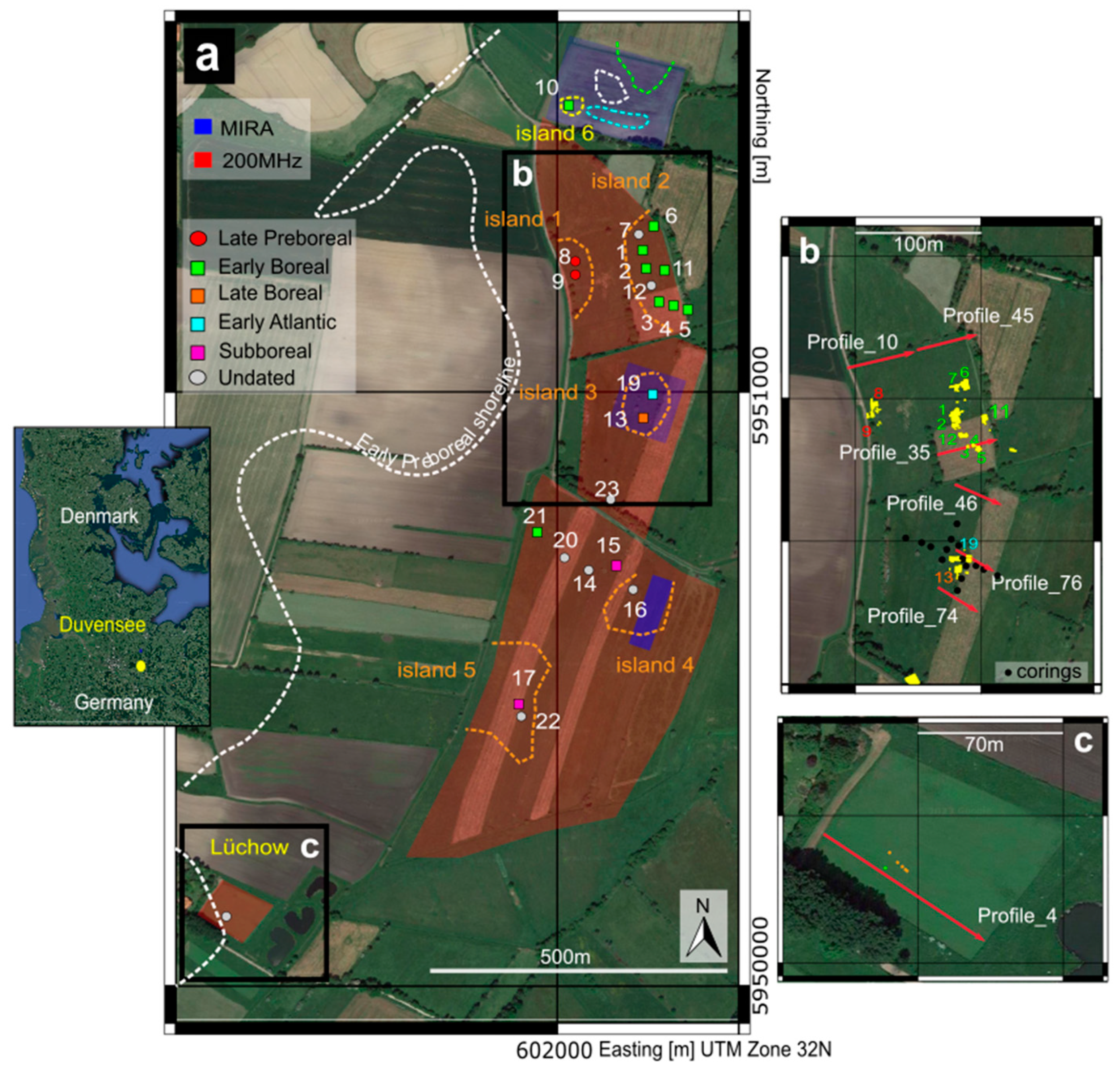
Figure 1. Area of investigation including archaeological findings and geophysical investigations. (a) Location of the Duvensee area together with the early Preboreal shoreline after [15]; the dating, location of excavated sites, and the positions of the former islands are based on the geophysical results reported in [17]. The numbers refer to the names of each campsite. The different colors indicate the time of occupation (modified after [16,17]). (b) Location of the GPR profiles reported in this study and the corings on Island 3. (c) Location of the GPR profile at the archaeological site Lüchow, an ongoing archeological investigation.
Remotesensing 15 03647 g001
Figure 2. Generalized scheme of lake siltation processes and the distribution of different sediment types (facies). Note that depending on the crossing of thresholds in water depth, certain sediment types might spread over large parts of a former lake basin (times 4, 5) while others are not formed any more. Thus, facies or sediment type alone yields only limited chronological information.
Remotesensing 15 03647 g002
Figure 3. (a) Comparison between GPR results and the stratigraphy. (top) Interpreted model for Duvensee peat bog development during the Mesolithic period (after [6,32]). (bottom) AGPR profile together with stratigraphy. The transitions between the sediment layers are indicated by dashed lines and the sediment by differently colored columns. The yellow line (Interface1) indicates the transition between coarse organic sediments (peat, coarse detritus gyttja) and finer organic sediments (fine detritus gyttja and calcareous gyttja). The green line (Interface2) indicates the transition between fine organic sediments (fine detritus gyttja and calcareous gyttja) and clayish-loamy sediments. The third reflection (Interface3) represents the transition between the clayish-loamy layer and the basal sands. (b) Forward modeling of the peat layer. The values of σ and εr are taken from Table 1 in [6]. To the left, the synthetic model is displayed, and the resulting radargram is shown on the right side. Using the synthetic model’s time axis as a reference, Interface1 occurs at 40 ns and Interface3 at ~50 ns. The synthetic model does not include Interface2 because we did not insert the silty mud layer in the starting model.
Remotesensing 15 03647 g003
Figure 4. GPR profiles belonging to the survey performed at Duvensee (200 MHz) in comparison with the stratigraphy. The internal layering of the peat is depicted by a cyan dotted line. For the profile location, see Figure 1b. The colored bars represent stratigraphic information from corings.
Remotesensing 15 03647 g004
Figure 5. 3D visualization of Island 3, close to the Mesolithic camps (we used the GPR Profiles from the 200 MHz and 400 MHz surveys). (a) The corings and the location of WP13 and WP19 are represented with the water level. The interface reported is the bottom of the peat layer (Interface1). (b) The internal peat stratification is displayed, and the campsites are in a dry location, confirming the validity of the model. The location of the corings is reported in Figure 1b, and the legend of the illustrated symbols for WP13 and WP19 is displayed in Figure 10.
Remotesensing 15 03647 g005
Figure 6. Focus on Island 2:(left) maps showing the SLOPE values for Sand (Interface_3) and Peat_1 together with the Mesolithic campsites; (right) maps of ASPECT considering the Sand (Interface_1) and Peat-1 interfaces.
Remotesensing 15 03647 g006
Figure 7. Summary of the radar facies identified in this study with correspondent description and interpretation. Each radar facies has a GPR profile combined with a line drawing of the corresponding interpretation and a symbol which will be used for interpretation in the course of this study. * corresponds to the sedimentological interpretation.
Remotesensing 15 03647 g007
Figure 8. GPR profiles showing the different GPR facies classified in Figure 7. The different symbols are re-ported for comparison and the different sediments as well. The dashed lines indicate the different sediment interfaces reported in [6,16] and in Figure 3 of this study. The illustrated profiles are from the 200 MHz survey.
Remotesensing 15 03647 g008
Figure 9. Distribution of the GPR facies on Islands 1,2, and 3. The different-colored points symbolize the detected GPR facies. (a) Axe fitting from Duvensee WP1 (©Archaeological State Museum Schleswig-Holstein) per [15]; (b) paddle found at WP2 (after [22]); (c) the main roasting hearth from WP11 (per [14]).
Remotesensing 15 03647 g009
Figure 10. 3D representation of the geographical conditions during the time of occupation at Island 1.
Remotesensing 15 03647 g010
Figure 11. 3D representation of the living conditions during the time of occupation at Island 2. The legend of the illustrated symbols is reported in Figure 10.
Remotesensing 15 03647 g011
Figure 12. (a) GPR profile at Lüchow. The colored lines indicated different sediments; red: sand interface and yellow: peat. The GPR stratigraphic pattern is displayed and localized close to the former excavation. We used a GSSI GPR antenna with a 200 MHz frequency, and the velocity of the radar wave for the time-to-depth conversion was estimated to be 0.072 ± 0.010 m/ns using the hyperbola-fitting function and the migration test tool Multichannel GPR. (b) GPR profile at Dümmer together with the 3D visualization of the Sand interface and location of the archeological sites [58]. We used a GSSI GPR dual frequency antenna with 300 and 800 MHz frequency, and the velocity of the radar wave for the time-to-depth conversion was estimated to be 0.055 ± 0.005 m/ns using the hyperbola-fitting function and the migration test tool Multichannel GPR [61].
Remotesensing 15 03647 g012
Table 1. Overview of the sites from Duvensee with a selection of specific characteristics (after [15]); question mark: not clear so far. The numbers in the round brackets close to the site’s name are the corresponding island of occupation.
SiteDating (14C)
cal BP
Specialized Lithic InventoryFireplaceHazelnut
Processing
Short-
Lived
(Used Only Once)
Note
WP1 (2)10,500–10,200noyesyesyes
WP2 (2)10,800–10,400noyesno?
WP3 (2)undated?yesno?
WP4 (2)undated??no?
WP5 (2)undatedyesyesyes?younger than WP1 and WP2
WP6 (2)10,400–9900yesyesyes?
WP7, WP12 (2)undated????Not real sites. Indeterminate find accumulations (charcoal, burned wood) in the shore area
WP8 (1)11,100–10,700noyesyesyes
WP9 (1)11,100–10,700noyesno?
WP10 (6)10,700noyesyesyes
WP11 (2)10,100–9900noyesyesno
WP13 (3)10,300–9400yesyesyesyes
WP15 (4)2600 cal BC????
WP17 (5)2600 cal BC????
WP14, WP16, WP20, WP23
(4)
undated????only stray surface finds
WP19 (3)9000–8400?yesnoyes
WP21 (4)10,300–9500?yes??
WP22 (5)undated????
Table 2. Processing and acquisition settings of the presented GPR Surveys. Further information is reported in [16,17].
200 MHz SurveyProcessing
Sampling frequency (MHz)4273Time zero correction
Number of samples471Spreading correction
Number of stacks8Background filter
Time window (ns)110k-highpasskmax = 0.01 m−1
Sampling interval (ns)0.02Band pass filter(50–400 MHz)
Radar velocity 0.055 ± 0.050 m/ns (hyperbola fitting)
400 MHz SurveyProcessing
Sampling frequency (MHz)10,340Dc-removal
Number of samples1024Trace interpolation
Number of stacks8Time zero correction
Time window (ns)99
Sampling interval (ns)0.07Normalization
Band pass filter(200–800 MHz)
Gain function(−20, 0, 10, 15, 20 dB).
Radar velocity be 0.072 ± 0.010 m/ns (hyperbola fitting)
Disclaimer/Publisher’s Note: The statements, opinions and data contained in all publications are solely those of the individual author(s) and contributor(s) and not of MDPI and/or the editor(s). MDPI and/or the editor(s) disclaim responsibility for any injury to people or property resulting from any ideas, methods, instructions or products referred to in the content.