
Dual-Parameter Simultaneous Full Waveform Inversion of Ground-Penetrating Radar for Arctic Sea Ice


Abstract

1. Introduction
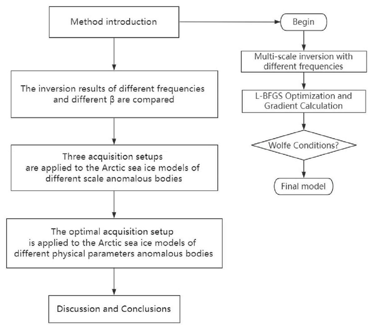
2. Methods
2.1. GPR Forward Modeling
2.2. Construction of FWI Misfit Function
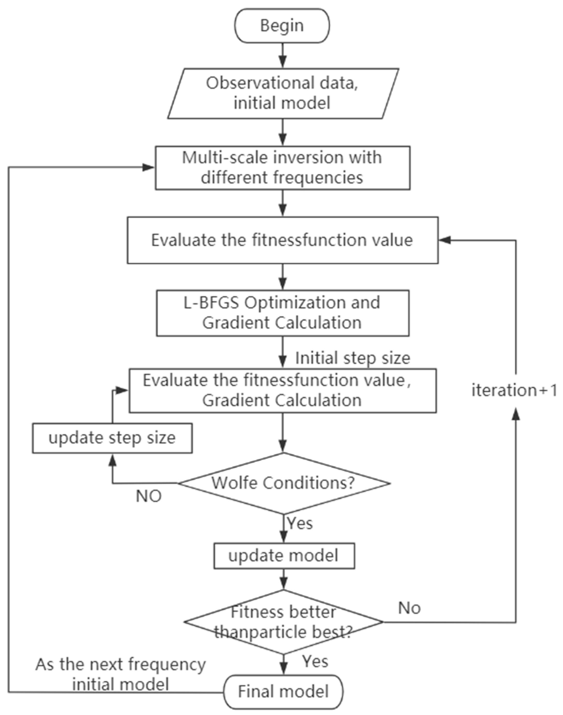
2.3. Optimization Strategy
2.3.1. Multiscale Inversion Strategy
2.3.2. TV Regularization Inversion Strategy
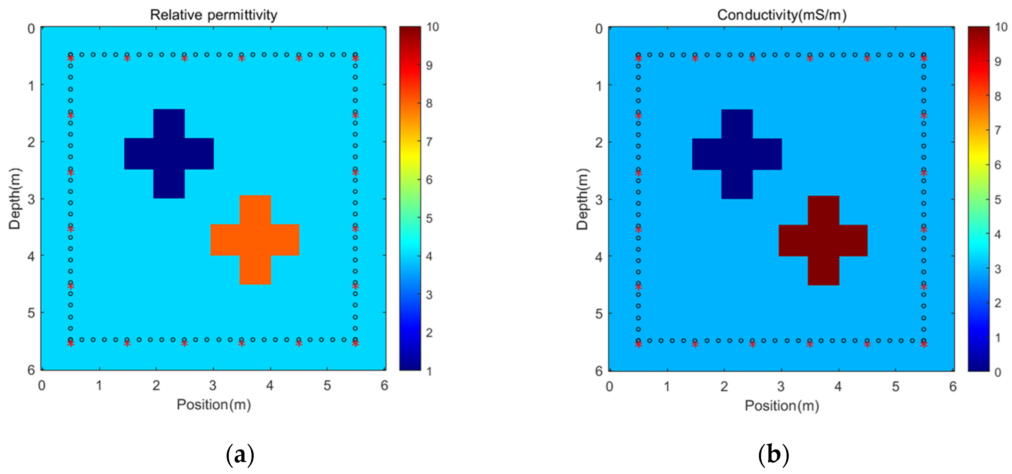
3. Numerical Examples
3.1. Multiscale Inversion Strategy Experiment
3.2. The Influence of Regulatory Factor β
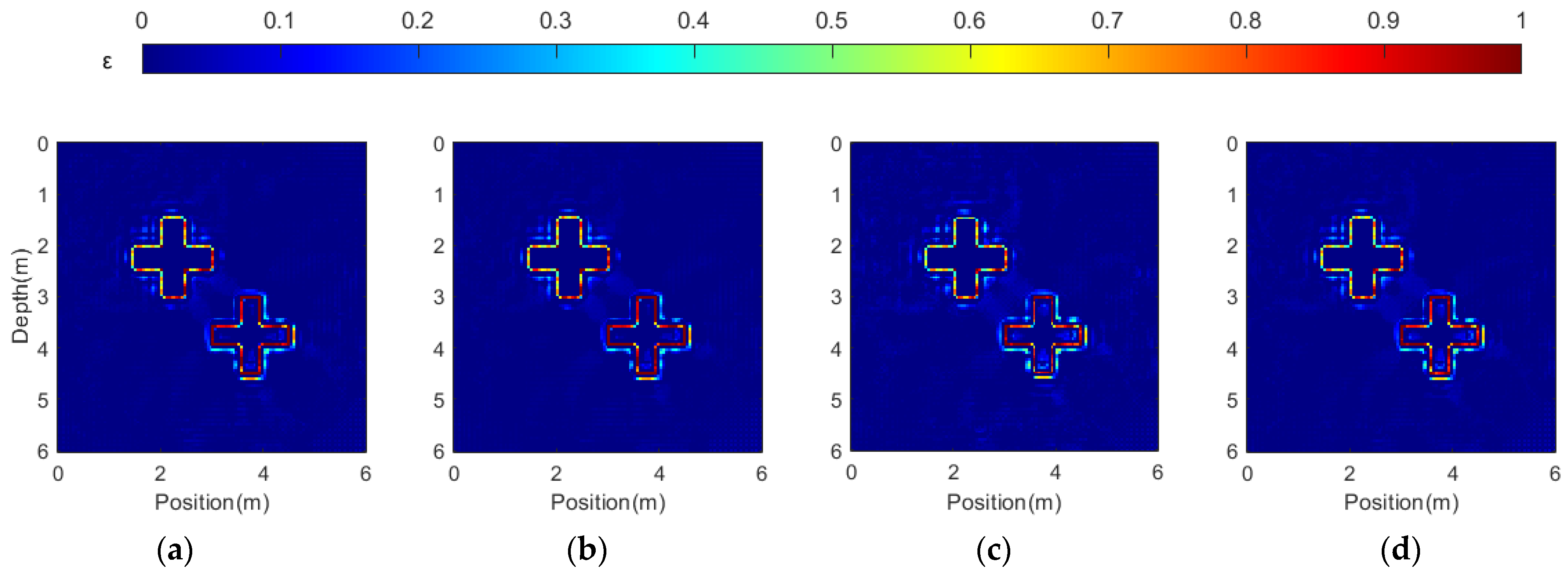
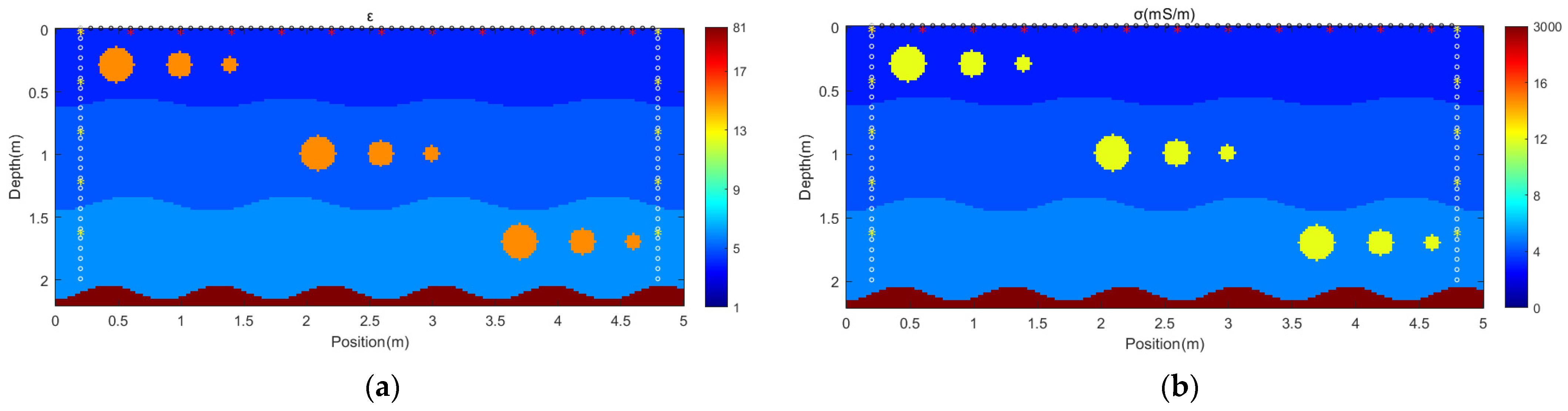
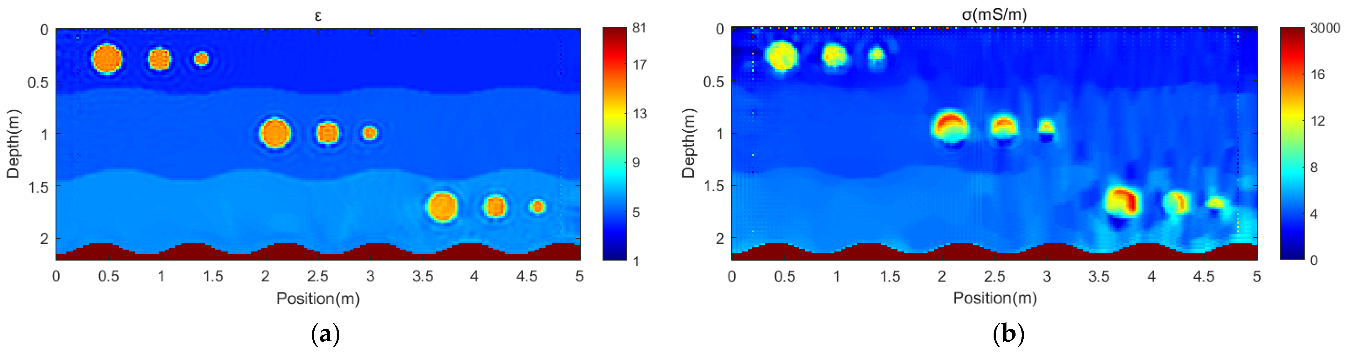
3.3. Sea Ice Inversion for Different Acquisition Setups
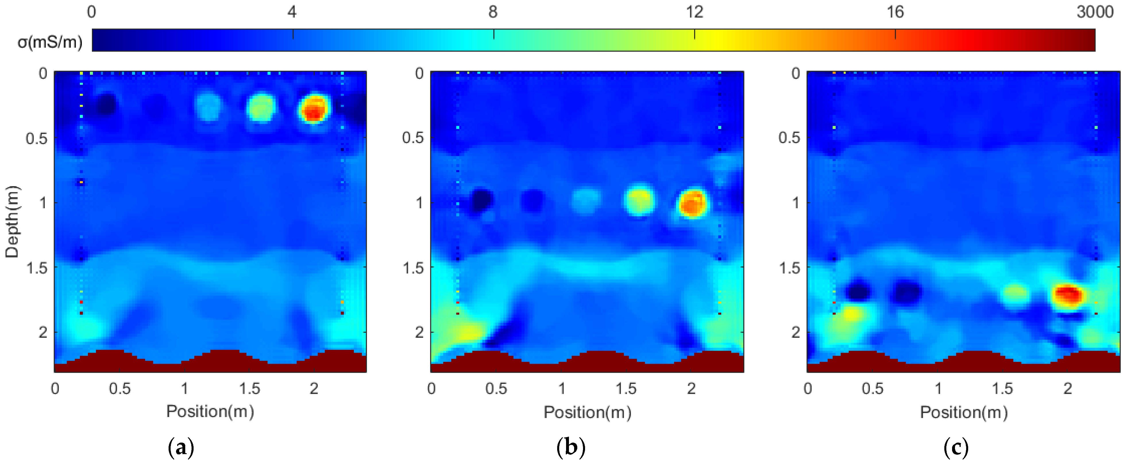
3.4. Sea Ice Inversion for Different Materials
4. Discussion
5. Conclusions
Author Contributions
Funding
Conflicts of Interest
References
- Serreze, M.C.; Barrett, A.P.; Stroeve, J.C.; Kindig, D.N.; Holland, M.M. The Emergence of Surface-Based Arctic Amplification. Cryosphere 2009, 3, 11–19. [Google Scholar] [CrossRef]
- Persico, R.; Colica, E.; Zappatore, T.; Giardino, C.; D’Amico, S. Ground-Penetrating Radar and Photogrammetric Investigation on Prehistoric Tumuli at Parabita (Lecce, Italy) Performed with an Unconventional Use of the Position Markers. Remote Sens. 2022, 14, 1280. [Google Scholar] [CrossRef]
- Liu, H.; Shi, Z.; Li, J.; Liu, C.; Meng, X.; Du, Y.; Chen, J. Detection of Road Cavities in Urban Cities by 3D Ground-Penetrating Radar. Geophysics 2021, 86, WA25–WA33. [Google Scholar] [CrossRef]
- Saarenketo, T.; Scullion, T. Road Evaluation with Ground Penetrating Radar. J. Appl. Geophys. 2000, 43, 119–138. [Google Scholar] [CrossRef]
- Solla, M.; González-Jorge, H.; Varela, M.; Lorenzo, H. Ground-Penetrating Radar for Inspection of In-Road Structures and Data Interpretation by Numerical Modeling. J. Constr. Eng. Manag. 2013, 139, 749–753. [Google Scholar] [CrossRef]
- Liu, Y.; Li, H.; Huang, M.; Chen, D.; Zhao, B. Ice Crevasse Detection with Ground Penetrating Radar Using Faster R-CNN. In Proceedings of the 2020 15th IEEE International Conference on Signal Processing (ICSP), Beijing, China, 6–9 December 2020; Volume 1, pp. 596–599. [Google Scholar] [CrossRef]
- Klotzsche, A.; Jonard, F.; Looms, M.C.; van der Kruk, J.; Huisman, J.A. Measuring Soil Water Content with Ground Penetrating Radar: A Decade of Progress. Vadose Zone J. 2018, 17, 1–9. [Google Scholar] [CrossRef]
- Galley, R.J.; Trachtenberg, M.; Langlois, A.; Barber, D.G.; Shafai, L. Observations of Geophysical and Dielectric Properties and Ground Penetrating Radar Signatures for Discrimination of Snow, Sea Ice and Freshwater Ice Thickness. Cold Reg. Sci. Technol. 2009, 57, 29–38. [Google Scholar] [CrossRef]
- Annan, A.P.; Diamanti, N.; Redman, J.D.; Jackson, S.R. Ground-Penetrating Radar for Assessing Winter Roads. Geophysics 2016, 81, WA101–WA109. [Google Scholar] [CrossRef]
- Fantello, N.; Parsekian, A.D.; Walter Anthony, K.M. Estimating Winter Ebullition Bubble Volume in Lake Ice Using Ground-Penetrating Radar. Geophysics 2018, 83, H13–H25. [Google Scholar] [CrossRef]
- Bradford, J.H.; Babcock, E.L.; Marshall, H.-P.; Dickins, D.F. Targeted Reflection-Waveform Inversion of Experimental Ground-Penetrating Radar Data for Quantification of Oil Spills under Sea Ice. Geophysics 2016, 81, WA59–WA70. [Google Scholar] [CrossRef]
- Cooke, D. Generalized Linear Inversion of Reflection Seismic Data. Geophysics 1983, 48, 665–676. [Google Scholar] [CrossRef]
- Tarantola, A. Inversion of Seismic Reflection Data in the Acoustic Approximation. Geophysics 1984, 49, 1259–1266. [Google Scholar] [CrossRef]
- Pratt, R.G. Inverse theory applied to multi-source cross-hole tomography: Part 2: Elastic wave-equation method1. Geophys. Prospect. 1990, 38, 311–329. [Google Scholar] [CrossRef]
- Sirgue, L.; Etgen, J.; Albertin, U. 3D Frequency Domain Waveform Inversion Using Time Domain Finite Difference Methods. In Proceedings of the 70th EAGE Conference and Exhibition incorporating SPE EUROPEC 2008, Rome, Italy, 9–12 June 2008. [Google Scholar] [CrossRef]
- Pratt, R.G. Seismic waveform inversion in the frequency domain, Part 1: Theory and verification in a physical scale model. Geophysics 1999, 64, 888–901. [Google Scholar] [CrossRef]
- Shin, C.; Cha, Y.H. Waveform Inversion in the Laplace Domain. Geophys. J. Int. 2008, 173, 922–931. [Google Scholar] [CrossRef]
- El Bouajaji, M.; Lanteri, S.; Yedlin, M. Discontinuous Galerkin Frequency Domain Forward Modelling for the Inversion of Electric Permittivity in the 2D Case. Geophys. Prospect. 2011, 59, 920–933. [Google Scholar] [CrossRef]
- Meles, G.A.; Van Der Kruk, J.; Greenhalgh, S.A.; Ernst, J.R.; Maurer, H.; Green, A.G. A New Vector Waveform Inversion Algorithm for Simultaneous Updating of Conductivity and Permittivity Parameters from Combination Crosshole/Borehole-to-Surface GPR Data. IEEE Trans. Geosci. Remote Sens. 2010, 48, 3391–3407. [Google Scholar] [CrossRef]
- Ren, Q. Inverts Permittivity and Conductivity with Structural Constraint in GPR FWI Based on Truncated Newton Method. J. Appl. Geophys. 2018, 151, 186–193. [Google Scholar] [CrossRef]
- Métivier, L.; Bretaudeau, F.; Brossier, R.; Operto, S.; Virieux, J. Full Waveform Inversion and the Truncated Newton Method: Quantitative Imaging of Complex Subsurface Structures. Geophys. Prospect. 2014, 62, 1353–1375. [Google Scholar] [CrossRef]
- Jorge, N.; Stefen, W. Numerical Optimization; Springer Science & Business Media: Berlin/Heidelberg, Germany, 2006. [Google Scholar]
- Lavoué, F.; Brossier, R.; Métivier, L.; Garambois, S.; Virieux, J. Two-Dimensional Permittivity and Conductivity Imaging by Full Waveform Inversion of Multioffset GPR Data: A Frequency-Domain Quasi-Newton Approach. Geophys. J. Int. 2014, 197, 248–268. [Google Scholar] [CrossRef]
- Nilot, E.; Feng, X.; Zhang, Y.; Zhang, M.; Dong, Z.; Zhou, H.; Zhang, X. Multiparameter Full-Waveform Inversion of on-Ground GPR Using Memoryless Quasi-Newton (MLQN) Method. In Proceedings of the 2018 17th International Conference on Ground Penetrating Radar (GPR), Rapperswil, Switzerland, 18–21 June 2018; pp. 1–4. [Google Scholar] [CrossRef]
- Virieux, J.; Operto, S. An Overview of Full-Waveform Inversion in Exploration Geophysics. Geophysics 2009, 74, WCC1–WCC26. [Google Scholar] [CrossRef]
- Meles, G.A.; Greenhalgh, S.; Maurer, H.R.; Green, A.G.; van der Kruk, J. GPR Full Waveform Sensitivity and Resolution Analysis Using an FDTD Adjoint Method. In Proceedings of the 2011 6th International Workshop on Advanced Ground Penetrating Radar (IWAGPR), Aachen, Germany, 22–24 June 2011; pp. 1–6. [Google Scholar] [CrossRef]
- Zhou, Z.; Klotzsche, A.; Hu, J.; Vereecken, H. Using Low-Wavenumber Information in Crosshole GPR FWI by Considering Angle Difference Identity with Cosine Approach: A Synthetic Study. In First International Meeting for Applied Geoscience & Energy Expanded Abstracts; Society of Exploration Geophysicists: Tulsa, OK, USA, 2021; pp. 553–557. [Google Scholar] [CrossRef]
- Jin, Y.; Zi, Y.; Wu, X.; Chen, J. An Enhanced GPR FWI Scheme with Low-Frequency Data Extrapolated by Progressive Transfer Learning. In Proceedings of the 2022 IEEE USNC-URSI Radio Science Meeting (Joint with AP-S Symposium), Denver, CO, USA, 10–15 July 2022; pp. 120–121. [Google Scholar] [CrossRef]
- Fu, C.; Jiang, Y.; Xie, Z.; Li, X.; Li, Y.; Li, K.; Zhao, Y.; Zhang, F.; Jiang, P. Full Waveform Inversion of Common-Offset Ground-Penetrating Radar Based on a Special Source Wavelet and Multiple Integral Wave-Field Transform. J. Appl. Geophys. 2022, 206, 104795. [Google Scholar] [CrossRef]
- Vogel, C.R. Computational Methods for Inverse Problems. In Computational Methods for Inverse Problems; Frontiers in Applied Mathematics; Society for Industrial and Applied Mathematics: Philadelphia, PA, USA, 2002; pp. 129–150. [Google Scholar] [CrossRef]
- Feng, D.; Wang, X.; Zhang, B. A Frequency-Domain Quasi-Newton-Based Biparameter Synchronous Imaging Scheme for Ground-Penetrating Radar with Applications in Full Waveform Inversion. IEEE Trans. Geosci. Remote Sens. 2021, 59, 1949–1966. [Google Scholar] [CrossRef]
- Wang, X.; Feng, D. Multiparameter Full-Waveform Inversion of 3-D On-Ground GPR with a Modified Total Variation Regularization Scheme. IEEE Geosci. Remote Sens. Lett. 2021, 18, 466–470. [Google Scholar] [CrossRef]
- Feng, D.; Liu, Y.; Wang, X.; Ding, S. Efficient Source-Independent Full Waveform Dual-Parameter Inversion of Common-Offset GPR Data. J. Appl. Geophys. 2023, 208, 104891. [Google Scholar] [CrossRef]
- Mozaffari, A.; Klotzsche, A.; Warren, C.; He, G.; Giannopoulos, A.; Vereecken, H.; van der Kruk, J. 2.5D Crosshole GPR Full-Waveform Inversion with Synthetic and Measured Data. Geophysics 2020, 85, H71–H82. [Google Scholar] [CrossRef]
- Liu, B.; Ren, Y.; Liu, H.; Xu, H.; Wang, Z.; Cohn, A.G.; Jiang, P. GPRInvNet: Deep Learning-Based Ground-Penetrating Radar Data Inversion for Tunnel Linings. IEEE Trans. Geosci. Remote Sens. 2021, 59, 8305–8325. [Google Scholar] [CrossRef]
- Liu, X.; Liu, S.; Luo, C.; Jiang, H.; Li, H.; Meng, X.; Feng, Z. Source-Independent Waveform Inversion Method for Ground Penetrating Radar Based on Envelope Objective Function. Remote Sens. 2022, 14, 4878. [Google Scholar] [CrossRef]
- Liu, T.; Klotzsche, A.; Pondkule, M.; Vereecken, H.; Su, Y.; Van Der Kruk, J. Radius Estimation of Subsurface Cylindrical Objects from Ground-Penetrating-Radar Data Using Full-Waveform Inversion. Geophysics 2018, 83, H43–H54. [Google Scholar] [CrossRef]
- Feng, D.; Ding, S.; Wang, X.; Su, X.; Liu, S.; Cao, C. Wavefield Reconstruction Inversion Based on the Multi-Scale Cumulative Frequency Strategy for Ground-Penetrating Radar Data: Application to Urban Underground Pipeline. Remote Sens. 2022, 14, 2162. [Google Scholar] [CrossRef]
- Feng, D.; Liu, Y.; Wang, X.; Zhang, B.; Ding, S.; Yu, T.; Li, B.; Feng, Z. Inspection and Imaging of Tree Trunk Defects Using GPR Multifrequency Full-Waveform Dual-Parameter Inversion. IEEE Trans. Geosci. Remote Sens. 2023, 61, 5903715. [Google Scholar] [CrossRef]
- Meles, G.; Greenhalgh, S.; Der Kruk, J.V.; Green, A.; Maurer, H. Taming the Non-Linearity Problem in GPR Full-Waveform Inversion for High Contrast Media. J. Appl. Geophys. 2011, 73, 174–186. [Google Scholar] [CrossRef]
- Dai, Q.; Zhang, H.; Zhang, B. An Improved Particle Swarm Optimization Based on Total Variation Regularization and Projection Constraint with Applications in Ground-Penetrating Radar Inversion: A Model Simulation Study. Remote Sens. 2021, 13, 2514. [Google Scholar] [CrossRef]
- Pfaffling, A.; Haas, C.; Reid, J.E. Direct Helicopter EM—Sea-Ice Thickness Inversion Assessed with Synthetic and Field Data. Geophysics 2007, 72, F127–F137. [Google Scholar] [CrossRef]
- Rodriguez-Alvarez, N.; Holt, B.; Jaruwatanadilok, S.; Podest, E.; Cavanaugh, K.C. An Arctic Sea Ice Multi-Step Classification Based on GNSS-R Data from the TDS-1 Mission. Remote Sens. Environ. 2019, 230, 111202. [Google Scholar] [CrossRef]
- Haas, C.; Gerland, S.; Eicken, H.; Miller, H. Comparison of Sea-ice Thickness Measurements under Summer and Winter Conditions in the Arctic Using a Small Electromagnetic Induction Device. Geophysics 1997, 62, 749–757. [Google Scholar] [CrossRef]
- Xing, J.; Song, R.; Zhen, S.; Jiang, X. Construction of the Central Arctic Sea Ice Structure and Acoustic Velocity Model at the Short-Term Ice Station During N11 CHINARE. IEEE Trans. Geosci. Remote Sens. 2022, 60, 5906307. [Google Scholar] [CrossRef]


Disclaimer/Publisher’s Note: The statements, opinions and data contained in all publications are solely those of the individual author(s) and contributor(s) and not of MDPI and/or the editor(s). MDPI and/or the editor(s) disclaim responsibility for any injury to people or property resulting from any ideas, methods, instructions or products referred to in the content. |
© 2023 by the authors. Licensee MDPI, Basel, Switzerland. This article is an open access article distributed under the terms and conditions of the Creative Commons Attribution (CC BY) license (https://creativecommons.org/licenses/by/4.0/).
Share and Cite
Liu, Y.; Liu, M.; Xing, J.; Ye, Y. Dual-Parameter Simultaneous Full Waveform Inversion of Ground-Penetrating Radar for Arctic Sea Ice. Remote Sens. 2023, 15, 3614. https://doi.org/10.3390/rs15143614
Liu Y, Liu M, Xing J, Ye Y. Dual-Parameter Simultaneous Full Waveform Inversion of Ground-Penetrating Radar for Arctic Sea Ice. Remote Sensing. 2023; 15(14):3614. https://doi.org/10.3390/rs15143614
Chicago/Turabian StyleLiu, Ying, Mengyuan Liu, Junhui Xing, and Yixin Ye. 2023. "Dual-Parameter Simultaneous Full Waveform Inversion of Ground-Penetrating Radar for Arctic Sea Ice" Remote Sensing 15, no. 14: 3614. https://doi.org/10.3390/rs15143614
APA StyleLiu, Y., Liu, M., Xing, J., & Ye, Y. (2023). Dual-Parameter Simultaneous Full Waveform Inversion of Ground-Penetrating Radar for Arctic Sea Ice. Remote Sensing, 15(14), 3614. https://doi.org/10.3390/rs15143614