Abstract
Spatially explicit reconstruction of historical land cover change is a prerequisite for a more comprehensive understanding of environmental changes. Anthropogenic activities have dramatically altered the land cover of the conterminous United States (CONUS), encroaching heavily on the primary vegetation. However, few datasets exist that depict the historical trajectory of forest and grassland cover changes in CONUS over the last millennium, and previous efforts have only focused on reconstructions for the last four centuries. By integrating remote sensing-derived land use/cover change (LUCC) data and potential vegetation data, we determined the potential extent of natural forest (PENF) and grassland (PENG) in CONUS. Based on a qualitative analysis of the trends and driving forces of forest and grassland changes, we devised a method of subtracting reconstructed historical cropland (1000–2000 AD) and built-up land (1850–2000 AD) from PENG and PENF to reconstruct a 5 min × 5 min grid dataset of forest and grassland cover at 13 time-points over the past millennium. The results showed that forest and grassland cover in CONUS underwent a slow decline (1000–1600 AD), an accelerated decline (1600–1800 AD), a dramatic decline (1800–1950 AD), and finally, a recovery (1950–2000 AD) over the study period. The modelled forest fraction decreased from 49% in 1000 AD to 33% in 2000 AD, representing a 32% area reduction, whereas the modelled grassland fraction decreased from 37% to 22%, representing a 42% area reduction. The reduction occurred primarily in the last 200 years, with forest and grassland reductions accounting for 86% and 97% of the total reduction over the millennium, respectively. Spatially, more than 80% of the land was originally covered by forests and grasslands, and the loss occurred mainly in the eastern CONUS and Great Plains over the past millennium. After the 1930s, farmland abandonment began in central and eastern CONUS, simultaneously with environmental protection laws. Federal government regeneration programs for forest and grassland resources and the Shelterbelt Project all contributed to a slowdown in forest and grassland decline and recovery in cover.
1. Introduction
Deforestation, land reclamation, agricultural intensification, and urban expansion have significantly changed the terrestrial surface and influenced soil physicochemical properties [1,2,3,4]. Primary vegetation destruction has consequences for climate and environmental change, including land degradation, carbon sequestration, and biodiversity loss [5,6,7,8]. Forests, grasslands, and shrublands together form the natural vegetation in CONUS. As the evolution of shrubs over the past millennium is not sufficiently supported, this paper investigates changes in historical forests and grasslands, and we hope that it can lay the groundwork for regional carbon cycle and climate change studies [9,10,11].
Substantial efforts have been made in global historical land use/cover change (LUCC) reconstruction with the promotion of international scientific projects, such as BIOME 300, Land Cover 6k, and Global Land Project. Ramankutty et al. [12] reconstructed global croplands and pastures over the past three centuries by linear backtracking from historical population and inventory data (Center for Sustainability and the Global Environment, SAGE). Klein Goldewijk et al. [13] developed the History Database of the Global Environment (HYDE 3.2), which provides a more comprehensive analysis of regional-scale cropland and pasture than previous versions. Pongratz et al. [14] established a global land use dataset (PJ, including rangelands) for the last millennium based on SAGE and HYDE. Kaplan et al. [15] used population and land use area per capita to estimate the anthropogenic land cover change scenario from 8000 BCE to 1850 AD. Scholars have reconstructed historical LUCC in Europe [16,17], Africa [18,19], South and Southeast Asia [20,21,22], and China [23,24,25,26] at the regional scale by integrating ancient local maps, remote sensing images, and historical documentation. These available datasets provide an indispensable reference for exploring and understanding the historical dynamics of coupled natural-human systems.
In the United States, rapid agricultural development and urbanization have permanently altered the land surface, resulting in the large-scale conversion of forests and grasslands to agricultural and anthropogenic landscapes. Vegetation destruction has several consequences for the regional carbon cycle, hydrology, and biodiversity [27]. Thus, mapping long-term forest and grassland cover is essential for understanding the carbon balance and ecological changes in terrestrial ecosystems in the United States.
Progress has been made in reconstructing historical forests and grasslands in the conterminous United States (CONUS). For example, Clawson et al. [28] estimated forest area from 1800 to 1977 using forest statistical data. Steyaert and Knox [29] produced detailed historical grassland cover maps for the eastern U.S. from 1650 to 1922. Mcallister [30] reproduced riverine LUCC in Oregon from the 19th century. Rhemtulla et al. [31] reconstructed historical LUCC in Wisconsin over the last two centuries based on historical evidence. Hanberry and Abrams [32] developed the spatially-explicit reconstruction of forests and grasslands in the central and western U.S. from 1786 to 1908 based on historical land use maps. Li et al. [33] produced gridded maps of land-use change in the CONUS with a 1 km resolution from 2020 back to 1630 by integrating multiple data sources. However, previous studies have mainly concentrated on historical LUCC reconstructions during the last four centuries. They used simplified methods for anthropogenic land cover changes before industrialisation, such as linear interpolating of the potential vegetation in 1000 AD and land cover in 1700 AD [34,35]. Meanwhile, global historical LUCC datasets are typically uncertain in space and time [10,36,37,38], making it impossible to observe regional-scale details [39,40,41,42]. As a result, a millennium dataset depicting the historical trajectory of forest and grassland cover changes across CONUS is still lacking.
In response to this need, this study first determined the potential extent of natural grassland (PENG) and forest (PENF) in CONUS before land reclamation (defined in Section 2.4) by integrating remote sensing-derived LUCC data and potential vegetation (RF99). Then, we utilized a method of deducting land affected by anthropogenic activities from PENG and PENF to reconstruct historical forest and grassland cover in CONUS from 1000 to 2000 AD. Our results can provide a reliable regional case for improving global historical LUCC scenarios and support the investigation of the long-term dynamics of coupled natural-human systems and the eco-environmental effects of historical LUCC.
2. Materials and Methods
2.1. Study Area
The CONUS is in the middle of North America, with generally flatter topography in the east and mountainous terrain in the west, vast plains, and abundant water. Temperate and subtropical climate zones predominate in CONUS. Compared to the global urbanization rate of approximately 50%, more than 80% of Americans resided in cities and suburbs during the same period.
The territory of the United States expanded from 13 states at its founding in 1776 to 50 states in 1959, and the land area increased from 0.8 million km2 to more than 9.6 million km2. However, owing to the limited availability of reconstruction resources, this study only covers the 48 states of CONUS (as shown in Figure 1), excluding Alaska and Hawaii.
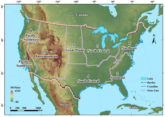
Figure 1.
Location and sub-regions of the study area.
To characterize the discrepancies in vegetation depletion between different geographic regions, we grouped the 48 states into eight sub-regions (Northeast, Southeast, North Central, South Central, Great Plains, Intermountain, Pacific Northwest, and Pacific Southwest) based on the spatial distribution structure of forests and grasslands, topographic factors of terrain, and socioeconomic development [43].
2.2. Data Sources
2.2.1. Historical Cropland Data
We obtained historical cropland cover in CONUS from the LandReclaUSA_1000–2000 dataset. Zhao et al. [44] estimated the cropland area and reclamation rate based on historical documents for CONUS (per capita cropland during pre-Columbian and colonial periods) over the past millennium. They then transformed the cropland area into a 10 km spatially-explicit dataset by devising a land reclamation suitability model, which quantified factors closely related to the spatial distribution of cropland (including slope, altitude, and agroclimatic potential productivity). Based on reliable historical evidence and time-segment and subregion reconstruction, this time-series gridded dataset objectively depicts the cropland distribution of CONUS per century from 1000 to 1800 and for 50 years after 1850. Table 1 presents the datasets used in this study.

Table 1.
Summary of datasets.
2.2.2. Remote Sensing-Derived LUCC Data
This study used the 2001, 2011, and 2019 National Land Cover Database (NLCD 2019) published by the United States Geological Survey (USGS), which is available at https://www.usgs.gov/ (accessed on 15 January 2022). The NLCD uses spectral, spatial, temporal, and ancillary data as input and adopts digital change detection methods and random forest models to identify land cover and changes for the U.S. [45,46]. The long-term land cover monitoring program for the U.S. provides Landsat-based (Thematic Mapper, TM) digitally produced continental-scale data with a resolution of 30 m × 30 m at five-year intervals [47]. It contains 17 land cover classes, with overall classification accuracies at Level II of approximately 83%, 82%, and 87% in 2001, 2011, and 2019, respectively [46,48,49,50,51].
2.2.3. Potential Vegetation Data
We referenced the global potential vegetation data (RF99) created by Ramankutty et al. [12]. These data were synthesized by replacing anthropogenic land in the DISCover dataset with modelled natural vegetation. It contains 15 land cover classes with a spatial resolution of 5 min 5 min. Considering that RF99 data has been widely cited [26,52] and after comparison showed macro-scale vegetation patterns similar to those of CONUS, we believe that the RF99 map is applicable to the U.S. These data were used to determine the potential extent of the natural forest and grassland cover.
2.2.4. Other Data
The administrative divisions of the 48 states in CONUS are from the Open Street Map (https://www.openstreetmap.org/, accessed on 14 January 2022). The urban and cultivated land areas of each state were derived from the CONUS annual LULC 1630–2020 dataset [33]. This dataset utilized multi-source data and machine learning methods to reconstruct historical annual LUCC with a spatial resolution of 1 km × 1 km. It provided a long-term description of built-up land with higher resolution and consistency for CONUS.
2.3. Data Processing
2.3.1. Determination of Land Cover Types
The Food and Agriculture Organization of the United Nations (FAO) defines forests as “Land spanning more than 0.5 ha with trees higher than 5 m and a canopy cover of more than 10%, or trees able to reach these thresholds in situ”. We adopted the FAO definition in this study, and shrublands and savannahs were not considered woodlands. In phytogeography, grasslands are defined as geographic areas dominated by natural herbaceous plants with 10% or more coverage [52]. In this study, shrublands and pastures were not included in grasslands. As the land cover types of the NLCD and RF99 data are inconsistent, this study consolidated these types in the two datasets based on the above-mentioned concepts of forest and grassland to make them comparable. Among the 17 land cover types in the NLCD dataset, types 41, 42, and 43 corresponded to deciduous, evergreen, and mixed forests, respectively, all of which were merged into forest. The grassland was described as herbaceous (coded 71). Open water, perennial snow/ice, and barren land were encoded as 11, 12, and 31, respectively, and combined with unclassified (0) into unclassified or unused land. The remainder represents the possible distribution of historical forest or grassland in current non-forest and non-grassland areas. The RF99 dataset contains 15 different categories of land cover, coded from 1 to 15. Codes 1 through 8 are related to woodlands, and we grouped them as forest, whereas code 10 is grassland. We segregated forest and grassland cover from RF99 for subsequent calculations. The consolidation of vegetation types is presented in Table 2.

Table 2.
Consolidation of land cover types.
2.3.2. Resampling Strategy of Spatial Resolutions
The target spatial resolution of the gridded forest and grassland datasets was the same as that of RF99. The NLCD data (30 m × 30 m resolution) and historical cropland gridded data (10 km × 10 km resolution) were resampled and aggregated to 5 min × 5 min resolution using Resample and Aggregation tools in ArcGIS 10.5 for subsequent spatial overlay analysis with the RF99 data.
2.4. Methodology
The agricultural land of the United States is approximately 160 million hectares, accounting for approximately 10% of the global agricultural land, and per capita land resources rank among the highest in the world (FAOSTAT, 2020). “Land reclamation” means land once covered with vegetation was settled and cleared for agricultural purposes. Historically, people cultivated land primarily by cutting forests and clearing grasslands. Most of this cropland came at the expense of forests/woodlands/grasslands [12].
Most used cropland was concentrated southwest of CONUS before the 15th century. During the colonial period, croplands along the eastern seaboard expanded rapidly, and the reclamation rates in some areas reached 40% [44]. Following the War of Independence in 1776, CONUS experienced visible land use/cover changes dominated by land reclamation and urban expansion as the Industrial Revolution progressed [29]. In the late 19th century, cultivated lands shifted from eastern to midwestern CONUS because of the post-Civil War settlement of millions of pioneers, contributing to the increasingly important role of the Midwest in the rise of food production. Therefore, changes in forest and grassland cover were primarily influenced by anthropogenic deforestation and agricultural intensification before the 1850s, with cropland expansion being the dominant cause of forest and grassland losses.
After the 1850s, CONUS underwent a period of tremendous urbanization with social advancement. The urban area increased from less than 7000 km2 to 32,300 km2 [33], and its impact on forest and grassland cover became difficult to ignore. Subsequently, the increase in built-up areas has become another critical driving force of forest and grassland shrinkage. Using the same time intervals used for cropland reconstruction, we devised a time-phased method of deducting cropland and built-up land areas from potential vegetation to reconstruct historical forest and grassland gridding data for CONUS over the past millennium.
An overview of the gridding reconstruction methods is illustrated in Figure 2. First, we determined the potential vegetation extent (PENF and PENG) in the absence of anthropogenic activities, based on the qualitative analysis of decreasing trends in forest and grassland cover. Second, assuming that the dominant source of forest and grassland loss from 1000 to 1850 was land reclamation, we derived gridded historical cropland cover data and subtracted it from PENF and PENG to capture the forest and grassland cover changes of CONUS during this period. Third, assuming that the dominant driving forces for the forest and grassland reduction from 1850 to 2000 were cropland expansion and urban expansion, we subtracted both from PENF and PENG to determine the spatial distribution of forests and grasslands at the corresponding time points.
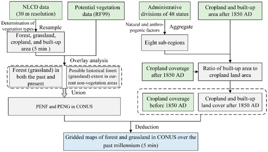
Figure 2.
Framework for reconstructing forest and grassland cover in CONUS over the last millennium.
2.4.1. Determination of the PENF and PENG
Potential vegetation most likely reflects the extent of vegetation without anthropogenic activities [12]. Continuous increase in population has accelerated agricultural development, and land cultivation continues to encroach on forests and grasslands. Most remote sensing-monitored forest and grassland areas were historically forest and grassland areas, and the current non-primary vegetation regions (e.g., cultivated land and populated land) might have been covered with forest and grass in the past [52].
Accordingly, the scheme for determining the PENF and PENG of CONUS before land reclamation is shown in Figure 3.
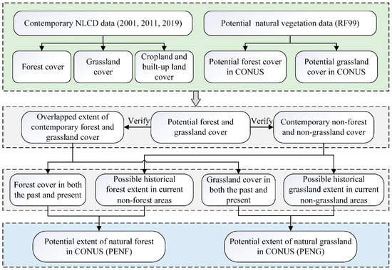
Figure 3.
Scheme for determining PENF and PENG in CONUS.
- (1)
- We first extracted contemporary forest, grassland, cropland, and built-up land from the NLCD datasets from 2001, 2011, and 2019. We clarified the maximum possible extent of each land cover type through spatial overlay analysis, which involved extracting the union sets of each land cover type in each year. Finally, we obtained data for the grid of potential forest and grassland cover from the RF99.
- (2)
- The maximum possible extent of contemporary forest and contemporary grassland spatially overlapped, and we used potential forest and potential grassland to distinguish between the two. If the overlapping grids are forested in the corresponding grids in the RF99 data, the grids were classified as forest, and if not, as grassland. Subsequently, the extent of contemporary forest (or grassland) was regarded as the spatial distribution of forest (or grassland) in the past and present.
- (3)
- To identify grids as historical forest or grassland covers, we superimposed the potential forest and grassland over the current non-forest and non-grassland cover, the overlap representing “the possible distribution of historical forest in current non-forest areas” and “the possible distribution of historical grassland in current non-grassland areas”.
- (4)
- The forest cover and grassland cover obtained in steps (2) and (3) were overlaid to determine the PENF and PENG of CONUS in the absence of anthropogenic activities (results shown in Figure 4). A bilinear interpolation resampling method was used to resample the 30 m NLCD data to 250 m and then aggregate it to 10 km to get proportional data. We set the RF99 data as the base and captured it when resampling the 10 km data to 5 min.
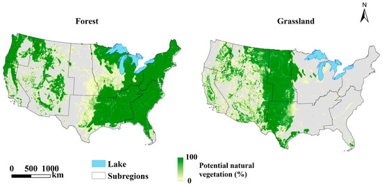 Figure 4. PENF and PENG in CONUS before land reclamation.
2.4.2. Subtracting Cropland from PENF and PENG
We developed cropland deduction rules based on the assumption that “cropland occupied the superior vegetation first and then proceeded to an inferior one”. Superior vegetation refers to the vegetation type with a relatively higher proportion in each grid. Inferior vegetation refers to the vegetation type with a relatively lower proportion in each grid.
First, the difference between PENF and PENG was calculated, and then, the threshold dividing the superior and inferior vegetation was determined based on the maximum coupling range between that difference and RF99. Finally, cropland from PENF (or PENG) in each 5 min grid cell was subtracted based on the proportion of forest (or grassland) occupied by land reclamation.
The specific steps were as follows (Table 3): (1) Based on the results of difference processing () and RF99, the grids were spatially classified as “forest-dominated” ( and classed as forest in RF99), “grassland-dominated” (), “not dominated by forest or grassland” ( not classified as either ), and “forest and grassland equally distributed” ( within the forest or grassland ranges in RF99). (2) Cropland was deducted from PENF (or PENG), where forest (or grassland) was the superior vegetation. In areas where forests or grasslands are not superior, it is considered that cropland expansion has not encroached on either, and thus, there is no deduction from potential natural forest and grassland cover. In areas where forest and grassland were equally distributed, the cropland was deducted proportionally from PENF and PENG (see Equation (1) for details).
where is the potential natural forest ratio, the potential natural grassland ratio, the land reclamation rate at time the difference between PENF and PENG, and the sum of PENF and PENG.

Table 3.
Classifications and rules of deduction.
2.4.3. Estimation of Urbanization Impact in PENF and PENG
Since the 1850s, the CONUS population has grown exponentially. As a result, urbanization and industrialization have accelerated the development of urban construction, exacerbating the shrinking trend of forests and grasslands. This study deduced the built-up area after 1850 (inclusive) based on deducting cultivated land to assess the impact of increasing urban area.
To objectively characterize forest and grassland changes, we aggregated the 48 states of CONUS into eight sub-regions, considering the spatial distribution of natural resources and the sequential colonization and settlement by European immigrants (Figure 1). Our reconstructed cropland showed good quantitative agreement with the CONUS annual LULC 1630–2020 dataset [33] but apparent discrepancies in spatial allocation. To ensure data consistency, we used the scaling relation between built-up and cropland areas in each sub-region [33] as the average coefficient of urbanization impact in this area (Table 4). Then, combined with the land reclamation rate [44], we determined the proportion of potential natural forest and grassland occupied by urban construction in each 5 min grid square. We excluded this from PENF and PENG after subtracting cropland and finally mapped the historical forest and grassland cover in CONUS at 1850, 1900, 1950, and 2000. The equation used is as follows:
where refers to the land reclamation rate at time t, and refers to the ratio of built-up area to cropland area at time t.

Table 4.
Ratio of urban to cropland area in the sub-regions after 1850 AD.
3. Results and Analysis
Using the method of subtracting land affected by anthropogenic activities from the PENF and PENG, this study reconstructed the historical forest and grassland cover across CONUS for 13 time-points over the past millennium, with a resolution of 5 min. We then analysed the spatiotemporal characteristics of forest and grassland cover and demonstrated the reasons for these changes.
3.1. Changes in Forest and Grassland Coverage from 1000 to 2000 AD
Figure 5 illustrates the changes in the forest and grassland areas in CONUS from 1000 to 2000 AD. The reconstruction results show a continuously decreasing trend over the past millennium, which can be divided into four phases: a slow decrease (1000–1600) followed by an accelerated decrease (1600–1800), a sharp decrease (1800–1950), and finally a short recovery (1950–2000). The forest coverage decreased from 49% in 1000 to 33% in 2000, representing a 42% area reduction, whereas the grassland coverage decreased from 37% to 22%, representing a 42% area reduction. The total loss of forest and grassland areas exceeded two million square kilometres during the study period and was mainly concentrated in the last two centuries. The vegetation coverage in CONUS gradually recovered after the mid-20th century.
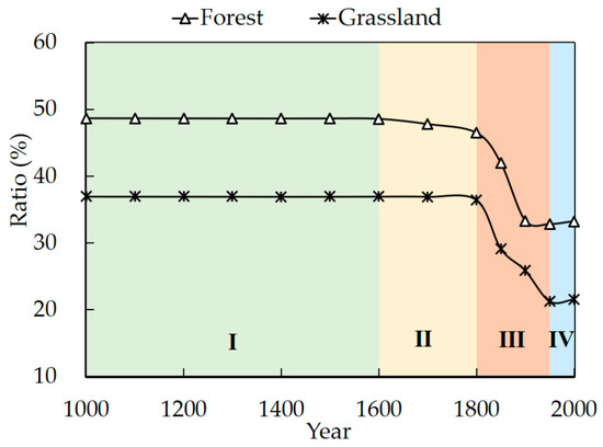
Figure 5.
Changes in forest and grassland coverages in the CONUS over the past millennium. (I, slow decrease; II, accelerated decrease; III, sharp decrease; IV, short recovery).
Before the arrival of Europeans in 1492, North America was an isolated continent. We calculated the 5 min × 5 min grid data drawn in this study and obtained the forest coverage of CONUS reached 49% a thousand years ago. The result is consistent with previous studies [33,53]. That is, approximately half of CONUS land was originally covered by natural forests, which made the forest the most visually dominant vegetation on the continent. At that time, the residents consisted of a small number of Native Americans who lived on farming, gathering, hunting, and fishing, and a complex subsistence agricultural economy prevailed along the CONUS eastern seaboard. As a result, natural forests and grasslands declined slowly before the 16th century, with no significant net changes. In 1400, the forest coverage fell to less than 49%, representing an area reduction of approximately 3000 km2, and grassland coverage fell to less than 37%, representing a reduction of about 1600 km2. Native Americans were often exposed to lethal epidemics and weapons after European contact (1492). The smallpox outbreak in the 16th and 17th centuries was a catastrophic cause of death for Amerindians that led to severe depopulation, followed by a significant abandonment or leaving fallow of expansive cropland. This interruption resulted in a brief recovery of forests and grasslands in the 16th and 17th century.
From the 17th to the 19th century, forest coverage declined to 47%, from 369.27 × 10⁴ km2 in 1600 to 353.42 × 10⁴ km2 in 1800, with an area reduction of 15.85 × 10⁴ km2. Grassland coverage declined to 36%, from 281.02 × 10⁴ km2 in 1600 to 277.17 × 10⁴ km2 in 1800, representing a reduction of 3.85 × 10⁴ km2. During this period, immigrants, as well as many American-born European-Americans, primarily moved from east to west. They obtained fuel through deforestation [54] and reclaimed land for cultivation and food production. Forests provided the most primitive survival materials for the development of European-American settlements. However, the influx of settlers and advanced technology accelerated the disappearance of natural vegetation.
Since the beginning of the 19th century, forest and grassland areas in CONUS have shrunk dramatically. Reconstruction results show that in the last two centuries, forest area has decreased by 100.77 × 10⁴ km2, accounting for 86% of the total loss in forest over the millennium, and grassland area has decreased by 113.45 × 10⁴ km2, accounting for 97% of the total loss in grassland. Before 1862, much of Iowa and southern Minnesota and northern Missouri through Illinois, Indiana, and western Ohio were mostly converted to farmland. Cropland encroached further into the prairies after 1870, associated with the Homestead Act of 1862, introduced with the intention of stimulating cropland expansion into the Great Plains and upper Midwest. Agriculture in CONUS became increasingly intensive and specialized later in the 20th century, with deforestation and land reclamation peaking in 1920 and remaining stable in the following decades.
After the 1930s, eastern CONUS experienced cropland abandonment. As a result, the decrease in forest and grassland areas slowed, and vegetation resources recovered to some extent. In 2000, the forest area in CONUS was 252.66 × 10⁴ km2, accounting for 33% of the total land area, and the grassland area was 163.72 × 10⁴ km2, accounting for 22% of the total land area.
Figure 6 shows the temporal changes in forest and grassland coverage in the eight sub-regions. In the past millennium, forest coverage was significantly higher than grassland coverage in all sub-regions except the Great Plains and Intermountain. The variation tendencies of forest and grassland coverage in North Central, South Central, Pacific Southwest, and Pacific Northwest are more consistent with the national characteristics. In 1600, more than 90% of the land area in the Northeast was covered by forest and less than 1% by grassland. In contrast, the Great Plains were dominated by grassland cover, with forests accounting for less than 5%. After centuries of land reclamation, the forest and grassland coverage in these two sub-regions experienced a rapid decline and recovered after the 1950s. In 2000, the forest fraction in the Northeast was approximately 70%, and the grassland fraction in the Great Plains dropped to less than 60%, whereas the forest coverage was less than 3%.
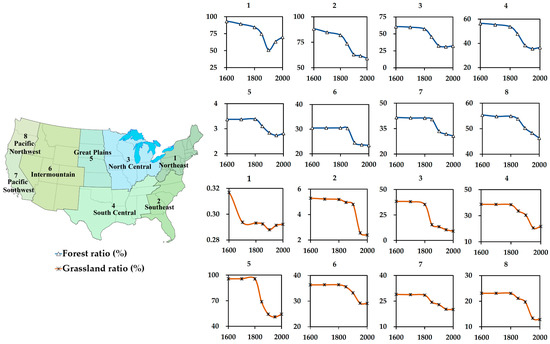
Figure 6.
Changes in forest and grassland coverage in sub-regions from 1600 to 2000 AD.
3.2. Spatial Distribution of Forest and Grassland Cover
3.2.1. Spatiotemporal Patterns of Forest Cover
Figure 7 shows the 5 min resolution reconstructed forest cover for CONUS from 1000 to 2000 AD. The results indicated that ~49% of CONUS land was originally covered by natural forests. Forests were the dominant pre-Columbian land cover. Woodlands were mainly concentrated in eastern CONUS and the West Coast (e.g., Washington, Oregon, and California). The most heavily-forested regions in the nation were the Appalachian Mountains in the east, the Rocky Mountains in the west (e.g., Colorado, Wyoming, and Idaho), and the eastern coastal areas. Approximately two-thirds to three-quarters of the forests were located in eastern CONUS, where the forest area is larger, and woodland density is higher than in the west. Geographically, forest changes were unidirectional, with agricultural land gains leading to a widespread loss of woodland.
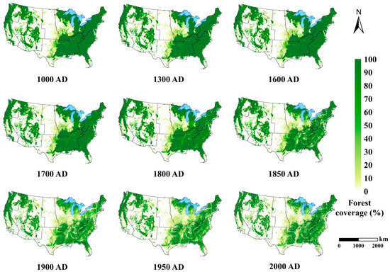
Figure 7.
Spatial distribution of forest cover in CONUS from 1000–2000 AD.
In 1492, Christopher Columbus’s discovery of the New World marked the beginning of European immigration to America. As a result, towns increased in number and size throughout the eastern CONUS seaboard. As immigration increased, the total number of urban centres increased from 205 in 1700 to over 1100 in 1810, and the population of a few major cities, such as Boston, Philadelphia, New York, and Baltimore, grew rapidly to over 50,000 each [55]. From the first arrival of Europeans to the first quarter of the 18th century, the indigenous population and European settlers engaged in subsistence farming, and settlement and agricultural development further disrupted the evolution of natural vegetation [33]. During the colonial period, the Americas began a massive transformation in forest and grassland cover. When forests were cleared, the land was left suitable for planting and grazing [56]. Arguably, cropland expansion and agricultural prosperity relied heavily on the ability of pioneering farmers to maintain a steady deforestation rate.
The decline in woodlands was not significant until 1800, after which the East and West were deforested to varying degrees. Deforestation was on the rise in the east of CONUS, with increased agricultural intensity, specialization, and concentration. Land reclamation was the dominant cause of deforestation, and the large amounts of timber and large tracts of cropland gained by clearing forests provided material conditions for social and economic reforms [57]. During the first half of the 19th century, the rapid pace of agricultural colonization swept through the remainder of the eastern forests, around and over the Appalachian Mountains, eventually reaching the Lake States and Gulf South. As the population swelled from 7.2 million in 1810 to 31 million in 1860, a steady stream of settlers created an unprecedented demand for farmland. In the South, a substantial amount of forest cover was cleared by African American slaves before 1860.
During the Civil War and post-war development period (from 1860 to the 1930s), clearing for agricultural purposes (e.g., to create new farms and to enlarge farm holdings or individual fields) was the leading cause of forest destruction. During the 50 years between 1860 and 1910, more land was cleared for cultivation through deforestation than during the 250 preceding years [58]. After the mid-19th century, agriculture in northeastern CONUS developed rapidly, and cultivated land significantly increased, primarily from the clearing of forests. Simultaneously, the beginning of urbanization and the upsurge of industrialization attracted an increasing number of European-Americans [59]. The growth and concentration of the population have led to a dramatic increase in urban areas, taking up large amounts of forested land. Accelerating deforestation began post-Civil War for the increased lumber production necessary to support the growing population and urbanization [60]. “Cutover” land started to appear in northern Pennsylvania, the Great Lakes states, and finally across much of the South during this period [61].
From the late 19th century to the 1930s, cropland abandonment occurred in the central and southeast CONUS, where cropland expansion centred on the Midwestern states, central California, and the Mississippi Alluvial Plain [53]. This meant a large-scale westward shift in the agricultural endeavour, followed by the slow and progressive abandonment of farms in many parts of the eastern forests, resulting in woodland recovery. The causes of cropland abandonment vary across regions. For example, poor soil and inaccessible terrain for modern machinery have left many isolated small plots of farmland abandoned in the east of Mississippi River. In contrast, government policies (e.g., the Homestead Act), internal combustion engine powered machinery, and advanced agricultural technology (e.g., drainage and irrigation systems) have contributed to subsequent agricultural development in the West [12].
Currently, areas with high forest coverage are confined to the Pacific Northwest coast, Idaho, eastern Minnesota, northern Wisconsin, eastern Maine, the Adirondack Mountains, the crest of the Appalachian Mountains, much of the lower southern states, and the Florida coast. The forest coverage between the Mississippi River and the ninety-seventh meridian is low, whereas large areas in the West are almost devoid of woodlands.
3.2.2. Spatiotemporal Patterns of Grassland Cover
Figure 8 illustrates the spatial pattern of grassland cover with a resolution of 5 min in CONUS from 1000–2000 AD. Grasslands were predominantly distributed in the western CONUS and central Great Plains, below 2000 m in elevation. Generally, temporal changes in grasslands were similar to those in woodlands. Before 1800, grassland changes were not spatially significant; however, after 1800, grassland conversion varied between different sub-regions. The extent of grassland changed correspondingly as the extent of agricultural land expanded or contracted.
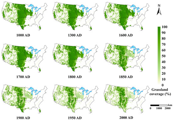
Figure 8.
Spatial distribution of grassland cover in CONUS during 1000–2000 AD.
Since the beginning of immigration, Europeans have made large-scale modifications to the natural vegetation of CONUS for clearing, cultivating, and ranching, with many of the primary grasslands of the prairies and savannas used for grazing [62]. The Homestead Act of 1862 allowed an individual to acquire 160 acres of government-owned land in the western territory if he farmed the land continuously for at least five years and paid a modest registration fee [63]. The policy not only conformed with the plan of the U.S. government to quickly develop state-owned land in the West but also provided an institutional guarantee for the westward movement. The Homestead Act greatly stimulated agricultural development in the Great Plains and the Midwestern areas, with a large-scale conversion of grasslands to cropland [64]. From the 1880s, more farms were established on open prairies and plains. Grassland coverage in the Great Plains declined from an initial 80~100% to 40~70% in 2000 (Figure 8).
After the 1930s, with the accelerated urbanization and threat of desertification in the West, the U.S. land policy objective began to change from “development” to “protection”. A series of land conservation laws were introduced to restrict excessive farming, grazing, and logging to combat soil erosion and restore the ecological environment of eroded areas. From 1938 to 1992, cropland declined over many regions, with the central and southeastern CONUS experiencing the most substantial losses [65]. The subsequent grassland recovery was mainly due to the abandonment or conversion of agricultural land in the Great Plains [66]. Farmland abandonment extended south to Kentucky, in formerly savanna areas. In Oklahoma and Texas, water constraints and intensive non-agricultural competition for land have led to a large-area transformation from farmland to grassland.
Currently, grasslands are concentrated in the Great Plains and scattered in the western mountains, with a reduced spatial extent and significant coverage decline. During the 1970s, the National Environmental Policy Act (NEPA, 1970) and Forest and Rangeland Renewable Resources Planning Act (RPA, 1974) were enacted to stop the creeping encroachment on grasslands and protect natural resources. Studies have suggested that grassland and scrub areas have increased since the Conservation Reserve Program (CRP) in 1985 [67]. In the 21st century, the U.S. has further strengthened its vegetation conservation efforts through scientific research, legislation, public education, and international cooperation to address the challenges posed by climate change, energy shortages, and other contemporary issues.
4. Discussion
4.1. Comparisons with Other Datasets
Although different datasets (e.g., SAGE, PJ, HYDE 3.2.1, and forest coverage from USDA) all showed a decline in forests and grasslands because of the expansion of cropland, the assessment of our model results revealed evident discrepancies in quantity, trends, and spatial patterns from 1500 to 2000 AD (Figure 9).
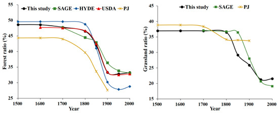
Figure 9.
Comparison of forest and grassland coverage among different datasets.
The PJ dataset differs significantly from our results in terms of both quantity and trends. In conjunction with the other data, changes in forest and grassland cover in CONUS were not significant until the 17th century. This study showed a general downward trend in forest and grassland coverage, which was similar to those in the HYDE and SAGE datasets. The difference is that the decline in woodland derived from HYDE was not significant during the 17th to 19th centuries, whereas our results revealed an accelerated decrease in the forest fraction, generally consistent with the SAGE dataset. In all datasets, there was a precipitous decline in the woodland area after the start of the 19th century, with HYDE showing the most dramatic change. A trough was reached around the 1950s, followed by a rebound, as reflected in our results and the HYDE and USDA data.
Grassland reconstructions are scarce, and most available results focus on pastures instead of grasslands, which is conceptually different from this study and cannot be directly compared. The overall trend of grassland changes in our study was in general agreement with that of SAGE. Both indicate that grassland coverage barely changed in the early period, declined sharply after the 19th century, and only moderated or increased in the late 20th century. However, the turning point in our analysis, when the modelled grassland acreage started to decline dramatically, was in 1800, whereas in the SAGE dataset, it was delayed to 1850.
4.2. Uncertainties and Prospects of the Reconstruction Methods
This study determined PENF and PENG using recent remote-sensing-monitored LUCC data and global potential vegetation. We first attempted to determine the extent of primary vegetation in the absence of anthropogenic activities based on a qualitative analysis of decreasing trends in forest and grassland cover. However, directly restoring the spatial distribution of primary vegetation is not practical due to a lack of adequate historical inventory data. Thus, this study considered the potential extent of natural forest (PENF) and grassland (PENG) as alternatives. For further exploration, the synthesis of multiple sources, such as pollen and archaeological data, should be considered to assist in reconstructing the native vegetation cover at large spatiotemporal scales to produce more objective results.
We reconstructed the historical forest and grassland cover in CONUS by subtracting the cultivated land area from the potential vegetation, which considered land reclamation to be the dominant driver of forest and grassland contraction. In addition, the built-up land area was deducted after 1850, representing the exclusion of the influence of vegetation depletion by industrialization and urbanization. However, many other natural and anthropogenic factors, such as wars, natural disasters, and climate change, have also influenced changes in land cover. For example, the wildfires also destroyed the forests. According to the records, the Miramichi and Piscataquis fires burned about 3 million acres in Maine and New Brunswick in 1825; the Wisconsin and Michigan fires in 1871 consumed 1.28 million and 2.5 million acres, respectively; and there were many others [53]. The wildfires depleted the lumber stand and eliminated the source of future forest growth. In recent years, the reduction of controlled burning and natural burns also has positively influenced tree coverage in prairies (such as Kansas). These scattered and sparse historical records render it difficult to quantify them on a large spatiotemporal scale. In future studies, more sources should be integrated to accurately reconstruct and reflect historical spatiotemporal changes in forests and grasslands.
5. Conclusions
This study developed a simple algorithm to reconstruct geographically explicit changes in forest and grassland cover in CONUS over the past millennium. The reconstruction results illustrate that forest and grassland coverage in CONUS has generally decreased over the past millennium, with the loss mainly occurring in eastern CONUS and the central Great Plains. Compared to previous studies, we have extended the historical period from the last four centuries to the past millennium. Additionally, we developed the strategy of subtracting the cropland from the potential vegetation to reconstruct the forest and grassland before the industrial period rather than linearly interpolating between the potential vegetation in 1000 and the land cover in 1700.
During the pre-Columbian period, the forest coverage of CONUS reached 49%, and the grassland coverage reached 37%. Woodland and meadow losses were mainly caused by Native American land reclamation and were not quantitatively significant. In the early colonial period, the rapid increase in population and urgent demand for food production led to the accelerated destruction of primary vegetation, with forests and grasslands being heavily exploited for farmland or pasture. The area of forest and grassland decreased by 15.85 × 10⁴ km2 and 3.85 × 10⁴ km2 from the 17th to 19th centuries, respectively. After the American War of Independence, the population entered a period of exponential growth accompanied by increased industrialization and urbanization. Timber consumption peaked in the 1880s, and during the last two centuries, forest loss accounted for 86% of the total loss over the past millennium, whereas grassland loss was 97%. Since the 1930s and 1940s, increased awareness of ecological conservation and sound institutions and policies have slowed down the loss of forests and grasslands in CONUS. The westward movement has contributed to cropland abandonment in the East and farmland expansion in the West, causing forest and grassland to recover to some extent. Modelled forest coverage rose from 32.81% in 1950 to 33.24% in 2000, and modelled grassland coverage increased from 21.26% to 21.54%. Deforestation was primarily for agriculture and settlement, and the reclaimed land was generally restored to vegetation cover once abandoned. The United States currently has 308 million hectares (33% of the total land area) of forest, which play a critical role in stabilising the environment and providing natural sanctuaries for wildlife and maintaining species diversity. Therefore, it is imperative for society of the United States to protect forest integrity.
Author Contributions
Conceptualisation, Y.W., F.Y. and F.H.; methodology, Y.W. and F.Y.; formal analysis, Y.W.; data curation, Y.W.; writing—original draft preparation, Y.W.; writing—review and editing, Y.W., F.Y. and F.H.; funding acquisition, F.Y. and F.H. All authors have read and agreed to the published version of the manuscript.
Funding
This research was funded by the National Key Research and Development Program of China (Grant No. 2017YFA0603304) and National Natural Science Foundation of China (Grant No. 42201263).
Data Availability Statement
The data presented in this study are available upon request from the corresponding author.
Acknowledgments
We thank Xiachuan Wu and Caishan Zhao for their efforts in this study.
Conflicts of Interest
The authors declare no conflict of interest.
References
- Ojima, D.S.; Galvin, K.A.; Turner, B.L. The global impact of land-use change. Bioscience 1994, 44, 300–304. [Google Scholar] [CrossRef]
- Brovkin, V.; Claussen, M.; Driesschaert, E.; Fichefet, T.; Kicklighter, D.; Loutre, M.F.; Matthews, H.D.; Ramankutty, N.; Schaeffer, M.; Sokolov, A. Biogeophysical effects of historical land cover changes simulated by six Earth system models of intermediate complexity. Clim. Dyn. 2006, 26, 587–600. [Google Scholar] [CrossRef]
- Houghton, R.; House, J.; Pongratz, J.; Werf, G.; Defries, R.; Hansen, M.; Le Quéré, C.; Ramankutty, N. Chapter G2 Carbon emissions from land use and land-cover change. Biogeosciences 2012, 9, 5125–5142. [Google Scholar] [CrossRef]
- Ellis, E.C.; Kaplan, J.O.; Fuller, D.Q.; Vavrus, S.; Goldewijk, K.K.; Verburg, P.H. Used planet: A global history. Proc. Natl. Acad. Sci. USA 2013, 110, 7978–7985. [Google Scholar] [CrossRef] [PubMed]
- Foley, J.A.; DeFries, R.; Asner, G.P.; Barford, C.; Bonan, G.; Carpenter, S.R.; Chapin, F.S.; Coe, M.T.; Daily, G.C.; Gibbs, H.K.; et al. Global consequences of land use. Science 2005, 309, 570–574. [Google Scholar] [CrossRef]
- Lal, R. Carbon sequestration. Philos. Trans. R. Soc. B Biol. Sci. 2008, 363, 815–830. [Google Scholar] [CrossRef]
- Johnson, C.N.; Balmford, A.; Brook, B.W.; Buettel, J.C.; Galetti, M.; Lei, G.C.; Wilmshurst, J.M. Biodiversity losses and conservation responses in the Anthropocene. Science 2017, 356, 270–274. [Google Scholar] [CrossRef]
- Zhang, C.P.; Ye, Y.; Fang, X.Q.; Li, H.S.B.; Wei, X.Q. Synergistic Modern Global 1 Km Cropland Dataset Derived from Multi-Sets of Land Cover Products. Remote Sens. 2019, 11, 2250. [Google Scholar] [CrossRef]
- Brovkin, V.; Sitch, S.; Von Bloh, W.; Claussen, M.; Bauer, E.; Cramer, W. Role of land cover changes for atmospheric CO2 increase and climate change during the last 150 years. Glob. Chang. Biol. 2004, 10, 1253–1266. [Google Scholar] [CrossRef]
- Kaplan, J.O.; Krumhardt, K.M.; Zimmermann, N.E. The effects of land use and climate change on the carbon cycle of Europe over the past 500 years. Glob. Chang. Biol. 2011, 18, 902–914. [Google Scholar] [CrossRef]
- Yang, F.; He, F.N.; Li, S.C.; Li, M.J.; Wu, P.F. A new estimation of carbon emissions from land use and land cover change in China over the past 300 years. Sci. Total Environ. 2023, 863, 160963. [Google Scholar] [CrossRef]
- Ramankutty, N.; Foley, J.A. Estimating historical changes in global land cover: Croplands from 1700 to 1992. Glob. Biogeochem. Cycles 1999, 13, 997–1027. [Google Scholar] [CrossRef]
- Klein Goldewijk, K.; Beusen, A.; Doelman, J.; Stehfest, E. New anthropogenic land use estimates for the Holocene; HYDE 3.2. Earth Syst. Sci. Data 2017, 9, 58. [Google Scholar] [CrossRef]
- Pongratz, J.; Reick, C.; Raddatz, T.; Claussen, M. A reconstruction of global agricultural areas and land cover for the last millennium. Glob. Biogeochem. Cycles 2008, 22, 3153. [Google Scholar] [CrossRef]
- Kaplan, J.O.; Krumhardt, K.M.; Ellis, E.C.; Ruddiman, W.F.; Lemmen, C.; Goldewijk, K.K. Holocene carbon emissions as a result of anthropogenic land cover change. Holocene 2010, 21, 775–791. [Google Scholar] [CrossRef]
- Loran, C.; Kienast, F.; Burgi, M. Change and persistence: Exploring the driving forces of long-term forest cover dynamics in the Swiss lowlands. Eur. J. For. Res. 2018, 137, 693–706. [Google Scholar] [CrossRef]
- Szymura, T.H.; Murak, S.; Szymura, M.; Radula, M.W. Changes in forest cover in Sudety Mountains during the last 250 years: Patterns, drivers, and landscape-scale implications for nature conservation. Acta Soc. Bot. Pol. 2018, 87, 3576. [Google Scholar] [CrossRef]
- Aleman, J.C.; Jarzyna, M.A.; Staver, A.C. Forest extent and deforestation in tropical Africa since 1900. Nat. Ecol. Evol. 2018, 2, 26–33. [Google Scholar] [CrossRef] [PubMed]
- Marchant, R.; Richer, S.; Boles, O.; Capitani, C.; Courtney-Mustaphi, C.J.; Lane, P.; Prendergast, M.E.; Stump, D.; De Cort, G.; Kaplan, J.O.; et al. Drivers and trajectories of land cover change in East Africa: Human and environmental interactions from 6000 years ago to present. Earth Sci. Rev. 2018, 178, 322–378. [Google Scholar] [CrossRef]
- Luo, P.P.; Takara, K.; Apip; He, B.; Nover, D. Reconstruction assessment of historical land use: A case study in the Kamo River basin, Kyoto, Japan. Comput. Geosci. 2014, 63, 106–115. [Google Scholar] [CrossRef]
- Tian, H.Q.; Banger, K.; Bo, T.; Dadhwal, V.K. History of land use in India during 1880–2010: Large-scale land transformations reconstructed from satellite data and historical archives. Glob. Planet. Chang. 2014, 121, 78–88. [Google Scholar] [CrossRef]
- Li, S.; He, F.; Liu, X.; Hua, L. Historical land use reconstruction for South Asia: Current understanding, challenges, and solutions. Earth Sci. Rev. 2023, 238, 104350. [Google Scholar] [CrossRef]
- Ye, Y.; Fang, X.Q. Spatial pattern of land cover changes across Northeast China over the past 300 years. J. Hist. Geogr. 2011, 37, 408–417. [Google Scholar] [CrossRef]
- He, F.N.; Yang, F.; Zhao, C.S.; Li, S.C.; Li, M.J. Spatially explicit reconstruction of cropland cover for China over the past millennium. Sci. China Earth Sci. 2023, 66, 111–128. [Google Scholar] [CrossRef]
- Jin, X.B.; Cao, X.; Du, X.D.; Yang, X.H.; Bai, Q.; Zhou, Y.K. Farmland dataset reconstruction and farmland change analysis in China during 1661–1985. J. Geogr. Sci. 2015, 25, 1058–1074. [Google Scholar] [CrossRef]
- Yang, F.; He, F.N.; Li, S.C. Spatially Explicit Reconstruction of Anthropogenic Grassland Cover Change in China from 1700 to 2000. Land 2020, 9, 270. [Google Scholar] [CrossRef]
- Birdsey, R.; Pregitzer, K.; Lucier, A. Forest carbon management in the United States: 1600–2100. J. Environ. Qual. 2006, 35, 1461–1469. [Google Scholar] [CrossRef]
- Clawson, M. Forests in the long sweep of American-history. Science 1979, 204, 1168–1174. [Google Scholar] [CrossRef] [PubMed]
- Steyaert, L.T.; Knox, R.G. Reconstructed historical land cover and biophysical parameters for studies of land-atmosphere interactions within the eastern US. J. Geophys. Res. 2007, 113, 8277. [Google Scholar] [CrossRef]
- McAllister, L.S. Reconstructing historical riparian conditions of two river basins in eastern Oregon, USA. Environ. Manag. 2008, 42, 412–425. [Google Scholar] [CrossRef]
- Rhemtulla, J.M.; Mladenoff, D.J.; Clayton, M.K. Legacies of historical land use on regional forest composition and structure in Wisconsin, USA (mid-1800s-1930s-2000s). Ecol. Appl. 2009, 19, 1061–1078. [Google Scholar] [CrossRef] [PubMed]
- Hanberry, B.B.; Abrams, M.D. Recognizing loss of open forest ecosystems by tree densification and land use intensification in the Midwestern USA. Reg. Environ. Chang. 2018, 18, 1731–1740. [Google Scholar] [CrossRef]
- Li, X.; Tian, H.; Pan, S.; Lu, C. Four-century history of land transformation by humans in the United States: 1630–2020. Earth Syst. Sci. Data 2022, 15, 1005–1035. [Google Scholar] [CrossRef]
- Goosse, H.; Arzel, O.; Luterbacher, J.; Mann, M.E.; Renssen, H.; Riedwyl, N.; Timmermann, A.; Xoplaki, E.; Wanner, H. The origin of the European “Medieval Warm Period”. Clim. Past 2006, 2, 99–113. [Google Scholar] [CrossRef]
- Stendel, M.; Mogensen, I.A.; Christensen, J.H. Influence of various forcings on global climate in historical times using a coupled atmosphere–ocean general circulation model. Clim. Dyn. 2006, 26, 1–15. [Google Scholar] [CrossRef]
- Goldewijk, K.K.; Beusen, A.; van Drecht, G.; de Vos, M. The HYDE 3.1 spatially explicit database of human-induced global land-use change over the past 12,000 years. Glob. Ecol. Biogeogr. 2011, 20, 73–86. [Google Scholar] [CrossRef]
- Zhao, C.S.; He, F.N.; Yang, F.; Li, S.C. Uncertainties of global historical land use scenarios in past-millennium cropland reconstruction in China. Quatern. Int. 2022, 641, 87–96. [Google Scholar] [CrossRef]
- Fang, X.Q.; Zhao, W.Y.; Zhang, C.P.; Zhang, D.Y.; Wei, X.Q.; Qiu, W.L.; Ye, Y. Methodology for credibility assessment of historical global LUCC datasets. Sci. China Earth Sci. 2020, 50, 1009–1020. [Google Scholar] [CrossRef]
- Li, S.C.; He, F.N.; Zhang, X.Z. A spatially explicit reconstruction of cropland cover in China from 1661 to 1996. Reg. Environ. Chang. 2016, 16, 417–428. [Google Scholar] [CrossRef]
- Kaplan, J.O.; Krumhardt, K.M.; Gaillard, M.J.; Sugita, S.; Trondman, A.K.; Fyfe, R.; Marquer, L.; Mazier, F.; Nielsen, A.B. Constraining the Deforestation History of Europe: Evaluation of Historical Land Use Scenarios with Pollen-Based Land Cover Reconstructions. Land 2017, 6, 91. [Google Scholar] [CrossRef]
- Yu, Z.; Lu, C. Historical cropland expansion and abandonment in the continental U.S. during 1850 to 2016. Glob. Ecol. Biogeogr. 2018, 27, 322–333. [Google Scholar] [CrossRef]
- Yang, F.; He, F.N.; Li, M.J.; Li, S.C. Evaluating the reliability of global historical land use scenarios for forest data in China. J. Geogr. Sci. 2020, 30, 1083–1094. [Google Scholar] [CrossRef]
- Oswalt, S.N.; Smith, W.B.; Miles, P.D.; Pugh, S.A. Forest Resources of the United States, 2012: A Technical Document Supporting the Forest Service 2010 Update of the RPA Assessment; U.S. Department of Agriculture, Forest Service, Washington Office: Washington, DC, USA, 2014.
- Zhao, C.S.; He, F.N.; Yang, F.; Wang, Y.F. Dataset of land reclamation in the continental United States from the 10th to 18th centuries. J. Glob. Chang. Data Dis. 2022, 6, 298–308. [Google Scholar] [CrossRef]
- Homer, C.; Dewitz, J.; Jin, S.; Xian, G.; Costello, C.; Danielson, P.; Gass, L.; Funk, M.; Wickham, J.; Stehman, S.; et al. Conterminous United States land cover change patterns 2001–2016 from the 2016 National Land Cover Database. ISPRS J. Photogramm. Remote Sens. 2020, 162, 184–199. [Google Scholar] [CrossRef] [PubMed]
- Wickham, J.; Stehman, S.V.; Sorenson, D.G.; Gass, L.; Dewitz, J.A. Thematic accuracy assessment of the NLCD 2019 land cover for the conterminous United States. GIsci. Remote Sens. 2023, 60, 2181143. [Google Scholar] [CrossRef]
- Collin Homer, J.D.; Yang, L.; Jin, S.; Danielson, P.; Xian, G.; Coulston, J.; Herold, N.; Wickham, J.; Megown, K. Completion of the 2011 National Land Cover Database for the Conterminous United States–Representing a Decade of Land Cover Change Information. Photogramm. Eng. Remote Sens. 2015, 81, 345–354. [Google Scholar] [CrossRef]
- Wickham, J.D.; Stehman, S.V.; Fry, J.A.; Smith, J.H.; Homer, C.G. Thematic accuracy of the NLCD 2001 land cover for the conterminous United States. Remote Sens. Environ. 2010, 114, 1286–1296. [Google Scholar] [CrossRef]
- Wickham, J.D.; Stehman, S.V.; Gass, L.; Dewitz, J.; Fry, J.A.; Wade, T.G. Accuracy assessment of NLCD 2006 land cover and impervious surface. Remote Sens. Environ. 2013, 130, 294–304. [Google Scholar] [CrossRef]
- Wickham, J.; Stehman, S.V.; Gass, L.; Dewitz, J.A.; Sorenson, D.G.; Granneman, B.J.; Poss, R.V.; Baer, L.A. Thematic accuracy assessment of the 2011 National Land Cover Database (NLCD). Remote Sens. Environ. 2017, 191, 328–341. [Google Scholar] [CrossRef]
- Wickham, J.; Stehman, S.V.; Sorenson, D.G.; Gass, L.; Dewitz, J.A. Thematic accuracy assessment of the NLCD 2016 land cover for the conterminous United States. Remote Sens. Environ. 2021, 257, 112357. [Google Scholar] [CrossRef]
- Yang, F.; He, F.; Li, S.C.; Li, M.J. Exploring Spatiotemporal Pattern of Grassland Cover in Western China from 1661 to 1996. Int. J. Environ. Res. Public Health 2019, 16, 3160. [Google Scholar] [CrossRef] [PubMed]
- Judd, R.; Williams, M. Americans and Their Forests: A Historical Geography. N. Engl. Q. 1990, 63, 521. [Google Scholar] [CrossRef]
- Bridenbaugh, C. Cities in the Wilderness: The First Century of Urban Life in America, 1625–1742; Oxford University Press: New York, NY, USA, 1971. [Google Scholar]
- Gabriel, R.H.; Paullin, C.O.; Wright, J.K. Atlas of the Historical Geography of the United States; The American Historical Review; American Geographicl Society of New York: New York, NY, USA, 1932; Volume 38. [Google Scholar]
- Belknap, J.; John, C.E. The History of New-Hampshire; Heritage Books, Inc.: Bowie, MD, USA, 2010. [Google Scholar]
- Williams, M. Clearing the United States forests: Pivotal years 1810–1860. J. Hist. Geogr. 1982, 8, 12–28. [Google Scholar] [CrossRef]
- Primack, M.L. Farm Formed Capital in American Agriculture, 1850 to 1910; Arno Press: New York, NY, USA, 1977. [Google Scholar]
- North, D. The Economic Growth of the United States, 1790–1860; Prentice-Hall: Hoboken, NJ, USA, 1961. [Google Scholar]
- Steer, H.B. Lumber Production in the United States, 1799–1946; U.S. Department of Agriculture: Washington, DC, USA, 1948.
- Cox, T.R. The Lumberman’s Frontier: Three Centuries of Land Use, Society, and Change in America’s Forests; Oregon State University Press: Corvallis, OR, USA, 2010. [Google Scholar]
- Vasey, D.E. An Ecological History of Agriculture, 10,000 B.C.–A.D.10,000; Iowa State University Press: Ames, IA, USA, 1999. [Google Scholar]
- Edwards, R. African Americans and the Southern Homestead Act. Gt. Plains Q. 2019, 39, 103–129. [Google Scholar] [CrossRef]
- Askins, R.A.; Chávez-Ramírez, F.; Dale, B.C.; Haas, C.A.; Herkert, J.R.; Knopf, F.L.; Vickery, P.D. Ornitho-logical Monographs No. 64, Conservation of Grassland Birds in North America: Understanding Ecological Processes in Different Regions: Report of the AOU Committee on Conservation. In Ornithological Monographs; American Ornithological Society: Chicago, IL, USA, 2007; pp. iii–viii, 1–46. [Google Scholar]
- Sohl, T.; Reker, R.; Bouchard, M.; Sayler, K.; Dornbierer, J.; Wika, S.; Quenzer, R.; Friesz, A. Modeled historical land use and land cover for the conterminous United States. J. Land Use Sci. 2016, 11, 476–499. [Google Scholar] [CrossRef]
- Sleeter, B.M.; Sohl, T.L.; Loveland, T.R.; Auch, R.F.; Acevedo, W.; Drummond, M.A.; Sayler, K.L.; Stehman, S.V. Land-cover change in the conterminous United States from 1973 to 2000. Glob. Environ. Chang. 2013, 23, 733–748. [Google Scholar] [CrossRef]
- Egbert, S.L.; Park, S.; Price, K.P.; Lee, R.Y.; Wu, J.P.; Nellis, A.D. Using conservation reserve program maps derived from satellite imagery to characterize landscape structure. Comput. Electron. Agric. 2002, 37, 141–156. [Google Scholar] [CrossRef]
Disclaimer/Publisher’s Note: The statements, opinions and data contained in all publications are solely those of the individual author(s) and contributor(s) and not of MDPI and/or the editor(s). MDPI and/or the editor(s) disclaim responsibility for any injury to people or property resulting from any ideas, methods, instructions or products referred to in the content. |
© 2023 by the authors. Licensee MDPI, Basel, Switzerland. This article is an open access article distributed under the terms and conditions of the Creative Commons Attribution (CC BY) license (https://creativecommons.org/licenses/by/4.0/).