Review

The Innovative Growth of Space Archaeology: A Brief Overview of Concepts and Approaches in Detection, Monitoring, and Promotion of the Archaeological Heritage

by
Marina Zingaro
1,
Giovanni Scicchitano
1,2,* and
Domenico Capolongo
1,2
1
Department of Earth and Geoenvironmental Sciences, University of Bari, 70125 Bari, Italy
2
Interdepartmental Research Center for Coastal Dynamics, University of Bari, 70125 Bari, Italy
*
Author to whom correspondence should be addressed.
Remote Sens. 2023, 15(12), 3049; https://doi.org/10.3390/rs15123049
Submission received: 5 May 2023 / Revised: 26 May 2023 / Accepted: 8 June 2023 / Published: 10 June 2023
(This article belongs to the Section Remote Sensing for Geospatial Science)

Abstract

:
Space Archaeology (SA), also known as Satellite Archaeology, Satellite Remote Sensing for Archaeology, or Archaeology from Space, is part of the wider interdisciplinary field of Remote Sensing for Archaeology. The application of satellite data in archaeological investigations has proven useful for landscape observation and analysis, the detection of archaeological traces, the reconstruction and monitoring of natural and anthropic processes, and the management and promotion of archaeological heritage. During the last few decades, the increasing number of SA studies has demonstrated innovative growth in archaeological disciplines due to the significant enhancement of spatial technologies, the advancement of visual inspection and image processing techniques, the development of data fusion methodologies, and the improvement of multi-temporal analysis methods. Therefore, a broad overview of the current situation in the concepts and approaches of SA is necessary to gain greater awareness of the current potentialities and limitations of this science to better address future studies. The present work provides a review of the scientific literature by exploring the different aspects of SA and the goals achieved to date in three main application fields: Detection, monitoring, and promotion of archaeological heritage. The contributions reviewed were divided within each of these three categories by analyzing the type of SA data and methods applied. The results indicate that (1) most studies aim to detect archaeological sites compared to monitoring and promotion; (2) optical images are used more than SAR data; and (3) techniques of image enhancement and visual interpretation are applied more than other data processing methods. This brief overview allows us to consider SA as an evolving discipline, an engine for cross-skills training, as well as a promising future science that can play a key role in the frontier of sustainable development and the new space economy.

1. Introduction

The interdisciplinary field of Remote Sensing for Archaeology (RSA) that applies satellite remote sensing to archaeology is defined as Space Archaeology (SA), also referred to as Satellite Archaeology, Satellite Remote Sensing for Archaeology, or Archaeology from Space [1,2]. RSA encompasses tools and techniques used to detect the physical characteristics of archaeological objects, traces, and sites below and above the Earth’s surface, respectively, through ground-based geophysical instrumentation and passive/active sensors mounted on drones, airplanes, and satellites [3,4].
Since its inception in the early twentieth century [5,6,7], RSA has provided significant support to archaeologists in landscape observation and analysis, detection of archaeological traces, reconstruction and monitoring of natural and anthropic processes, and management and protection of the archaeological heritage [8,9,10,11]. RSA has become an established discipline over time, as evidenced by the wide range of studies and projects that explore advanced technologies (multi-/hyperspectral sensors, Light Detection and Ranging (LiDAR), Synthetic Aperture Radar (SAR), Ground Penetrating Radar (GPR), Electrical Resistivity Tomography (ERT), etc.), techniques (photogrammetry, image processing, interferometry, visual inspection, thermal imaging, laser scanning, etc.), and integrated methodologies (multi-temporal change detection, machine learning, etc.) in relation to the scale and characteristics of the context under investigation. These studies involve both scientific community experts (archaeologists, geologists, geophysicists, computer scientists and physicists, Geographic Information System (GIS) experts, heritage specialists, etc.) and citizen scientists [12,13,14,15,16,17,18,19,20,21].
Remote sensing applications offer several advantages that have driven RSA’s long history: (i) Implicit non-invasiveness of the investigations; (ii) extraction of otherwise unavailable information; (iii) reduction in research time and costs; (iv) synoptic observation of large areas of the Earth’s surface; (v) accessibility to long time series of data; (vi) opportunity to analyze and monitor sites through spatial and temporal multi-scalar approaches [3,22,23,24].
The latter three benefits are offered specifically by the use of satellite data, which play a key role in improving the geographical, geomorphological, and topographic understanding of archaeological sites, helping in the investigation of human–environment interactions. As the evolution of Space Archaeology states, the potential of satellite data in archaeological applications began to emerge as early as the 1970s and 1980s, when the first images acquired by satellites, such as CORONA, Earth Resources Technology Satellites (ERTS/Landsat), and Shuttle Imaging Radar (SIR) became useful tools for recognizing archaeological heritage on the Earth’s surface [1,25]. In subsequent decades, archives of this imagery continued to be explored to observe variations in the physical environment (paleogeography, paleohydrography, etc.) and archaeological features (topographic and morphological surface characteristics, soil and crop marks, conservation and looting of sites, etc.) over time [26,27].
Since the 1990s and 2000s, concurrent with the technological advancement of existing satellite systems (for example, from Multispectral Scanner (MSS) to Thematic Mapper (TM), Enhanced Thematic Mapper (ETM), and ETM Plus of Landsat), the development of new satellite technologies and more innovative techniques has helped strengthen the potential of satellite data in archaeology. Therefore, satellite products, such as global digital elevation models (Advanced Spaceborne Thermal Emission and Reflection Radiometer (ASTER), Shuttle Radar Topography Mission (SRTM), etc.), high and very high spectral and spatial resolution images (Satellite Pour l’Observation de la Terre (SPOT), IKONOS, QuickBird, Geo-Eye, Worldview, TerraSAR-X, COSMO-SkyMed, etc.), platforms and software for satellite imagery analysis and processing (GIS systems, Google Earth™, Google Earth Engine™, Google Maps™, etc.) contributed to providing valuable sources of information for reconstructing and monitoring ancient landscapes [22,28,29,30].
Since then, and even more from the 2010s to the present day, the use of satellite data as a resource and source has become increasingly impressive, leading to the development and application of integrated methodologies that have led over time to the definition of global approaches in all fields of the archaeological discipline [2,7,31,32,33,34,35,36,37].
In SA history, space agencies have certainly played a decisive role. Space missions of the National Aeronautics and Space Administration (NASA) have included archaeological projects, from the use of Apollo 11 photography for identifying archaeological traces in Arizona to the introduction of a Space Archaeology Program [1,38]. Satellite programs, such as Copernicus from the European Space Agency (ESA) have allowed for open and free access to satellite data, software, and models, expanding the network of end-users, especially the range of possible applications to include cultural heritage management [39].
Therefore, the innovative growth of SA has led to an evolution of concepts and approaches that need to be reviewed to become more aware of both the current advancements and potential limitations determined by the application of satellite remote sensing in archaeology. Existing reviews have emphasized remote sensing in archaeology or SA by describing principles, key concepts, techniques, and methodologies, with the aim of discussing the success of remote sensing in archaeology. However, a review that focuses only on the application of satellite tools, methods, and data in each field of archaeological heritage investigation, describing the current contribution of space archaeology analytically and not only qualitatively, is missing. The present work provides for the first time a review of the scientific literature that explores SA in the three main application fields: Detection, monitoring, and promotion of archaeological heritage. In particular, detection means analysis and research of archaeological evidence [40], monitoring means reconstruction of the environmental and anthropic processes for the protection of the archaeological heritage [11], and promotion means valorization and large-scale dissemination of archaeological assets knowledge [41]. We do not intend to consider all the works published to date, but we have analyzed quantitatively a representative part of them and extracted useful information to describe the current SA scenario and possible links with the constantly advancing context of science. The main aim is to critically review SA literature from a new point of view to provide the scientific community with a new benchmark.

2. Material and Methods

A collection of 85 RSA works including scientific (journal and conference) papers, books, and technical reports was obtained in order to explore concepts and approaches and identify SA items to be analyzed. To achieve this, RSA special issues and review papers were considered in order to trace as many works as possible on the subject [3,4,6,7,23,29]. Then, an integer in ascending numerical order was assigned to each RSA item and, among them, a selection was applied to individualize 52 SA records that would be included in the database (see Supplementary Materials). It should be noted that SA works have been selected through a qualitative assessment that takes into account the meaningfulness of the scientific contribution and the scientific performance of the journal in which they are published. The selected sample was considered enough to test the new review methodology proposed herein, and thus it was not found necessary to further extend the search for other SA works. This choice is justified by the aim of the present work, which is to compile a non-exhaustive but representative review by means of a quantitative analysis. Furthermore, given the ever-increasing amount of the scientific literature in SA, it can be argued that it would be impossible to include all published SA works in a single review; rather, other future review works could be carried out.
The critical review of SA works was based on three steps: (1) Classification in categories through the recognition of corresponding application fields; (2) acquisition of information; (3) performance of statistical analysis.
(1)
Three main categories corresponding to SA application fields were individualized: Detection, monitoring, and promotion. In particular, detection includes SA works that apply the identification of buried archaeological traces and sites (crop/soil marks, micro-reliefs, geometric/radiometric features, etc.) and the investigation of the archaeological contexts (distribution and evolution of settlements, reconstruction of the ancient viability, etc.). Monitoring includes SA works that apply the observation over time of natural and anthropogenic processes for the preservation of archaeological sites (evaluation of geo-hazards, assessment of anthropic impact and checking of the integrity of archaeological sites, detection of looting, etc.). Promotion includes SA works that apply the broadcast of cultural (historic, geographic, topographic, ethnographic, etc.) value of the archaeological heritage. Fifty-two SA records were classified in these three groups on the basis of their target.
(2)
A focus on specific aspects was carried out by extracting information from each SA work: (i) Satellite data used (i.e., optical or SAR, and satellite missions); (ii) data analysis methodologies applied; (iii) country of archaeological sites investigated; (iv) country of the research institutions that affiliate work authors. Then, a review of the database was realized, in which each record is SA work and each extracted information is an attribute.
(3)
Geospatial and statistical analysis of data acquired was performed through the processing of graphs and maps by using QGIS® (http://qgis.org (accessed on 5 May 2023); version 3.16.1) and Microsoft Excel® (https://www.microsoft.com/it-it/microsoft-365/excel (accessed on 5 May 2023); version Office 2013-15) software.

3. Results

Figure 1 shows the result of the review analysis, which concerns the classification of SA works into application fields. It can be observed that most SA studies are focused on the detection of archaeological sites compared to monitoring and promotion, as demonstrated by the highest distribution rate in the detection category (63%, corresponding to 33 out of 52 SA works) compared to the other categories (31% and 6%, corresponding to 16 and 3 out of 52 SA works, respectively).
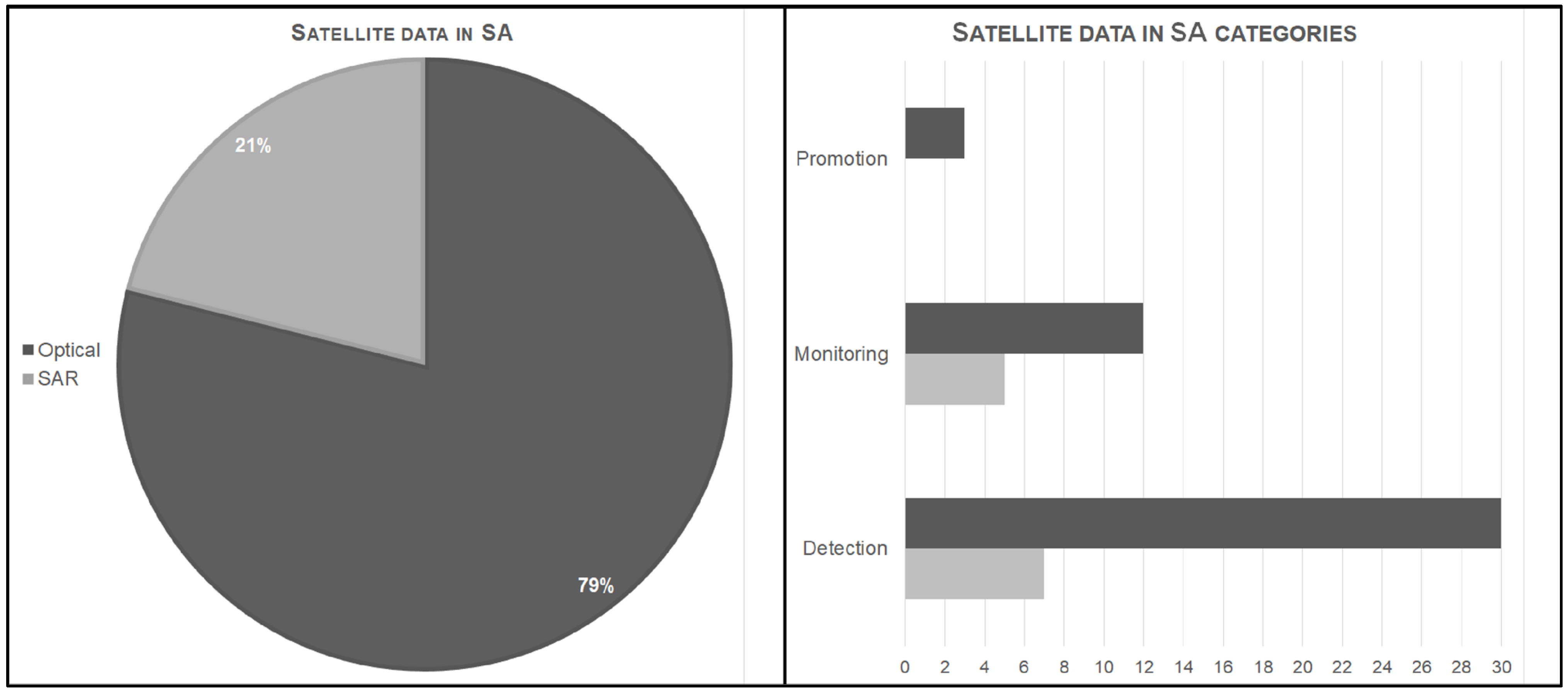
The acquisition and processing of data during the second and third steps of the review led to findings regarding the data and methodologies applied in SA. In particular, Figure 2 illustrates that optical data are used more frequently (79%, corresponding to 45 out of 52 works) than SAR data (12 out of 52 works). Furthermore, while optical data are employed in all SA categories, they are mostly used in detection (30 out of 52 works). In contrast, SAR data tend to be used equally in detection (in 7 works) and monitoring (in 5 works), but not in promotion. This outcome appears to be confirmed by the increased number of works that apply data acquired from satellites equipped with optical sensors, as shown in Figure 3.
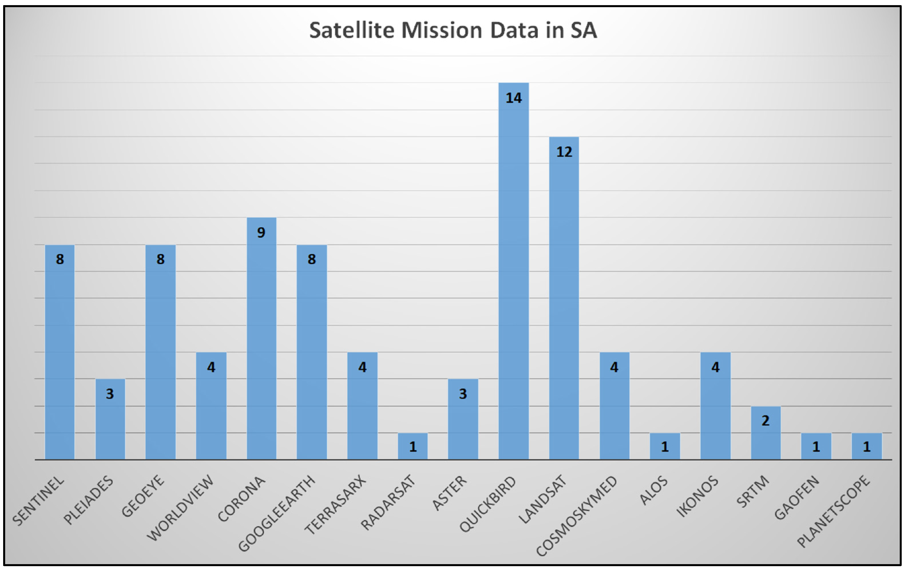
In particular, the chart in Figure 3 represents the satellite mission data used in the reviewed studies with their relative application frequency. It should be noted that (1) the most commonly used data are optical images from satellites, such as QuickBird, Landsat, Sentinel, Geo-Eye, and CORONA (respectively used in 14, 12, 8, 8, 9 works) and (2) the Google Earth platform, which provides access to high-resolution commercial satellite imagery, is also considered and included in the satellite mission data graph (used in 8 works).
The analysis of the methodologies revealed a variety of tools and methods, which can be grouped into approaches. Table 1 lists seven clusters of methodologies that were identified and defined using conventional names (i.e., abbreviated forms of their definitions).
Cluster 1 refers to the methodologies that use Spectral Band Indices (SBI) to detect surface anomalies by analyzing zonal differences in the reflectance values in different bands. SBI examples include the Normalized Difference Vegetation Index (NDVI) and Normalized Difference Water Index (NDWI), which are commonly used in archaeological investigations that use optical data, either single or time-series data. Several studies reviewed, including [42,43,44,45,46,47,48,49,50,51], have used these methods for detecting archaeological sites.
Cluster 2 involves the use of statistical techniques to extract archaeological features from large datasets of satellite imagery. The techniques include Principal Component Analysis (PCA), Tasseled Cap Transformation (TCT), Linear Discriminant Analysis (LDA), among others. These techniques have been widely used in archaeological investigations with satellite imagery, as shown by several studies [42,45,46,47,48,49,52,53,54,55].
Cluster 3 involves the use of comparative analyses on amplitude and coherence of Synthetic Aperture Radar (SAR) data to identify changes in surface characteristics and stability for the purpose of detecting and monitoring archaeological heritage. Some examples of studies that have used this approach include [56,57,58,59,60].
Cluster 4 comprises methodologies that apply Image Enhancement (IME) to improve spectral and spatial resolution, thereby increasing the possibility of identifying information useful for archaeological purposes. For example, techniques, such as image texture filters, band combinations, and false color are widely used to detect archaeological sites, and are often closely related to visual interpretation [42,44,45,54,61,62,63,64,65,66,67,68,69,70,71]. The latter is defined as Image Visual Inspection (IVI) and composes cluster 5, indicating the examination of satellite data to identify objects, such as crop/soil marks, morphological and/or geometric features, and the form of site damage, in order to support the analysis of archaeological sites, particularly with respect to their relation to the landscape.
Visual interpretation, which is a qualitative approach, is often integrated with other methodologies in both preparatory and final phases of archaeological analysis [58,61,65,66,72,73,74,75,76,77,78,79,80,81,82,83,84,85,86,87]. Cluster 6, on the other hand, includes methodologies that use advanced Algorithms of Image Processing (AIP) to automatically extract archaeological information from satellite data through a quantitative approach that relies on computer-based procedures. Techniques, such as pattern recognition, classification, edge detection, segmentation, and artificial intelligence data-driven methods, such as machine learning and deep learning are employed in an increasing number of studies in the field of satellite archaeology [44,53,55,62,63,68,83,88,89,90,91,92].
Cluster 7 includes methodologies that apply Digital Elevation Models (DEM) to better understand the cultural landscape, constituted by archaeological sites and their topographical and geomorphological context, by improving the interpretation of the interaction between human and natural processes. Stereo-pairs of satellite images are used to generate elevation models, and satellite DEMs are implemented in archaeological investigations [49,84,93].
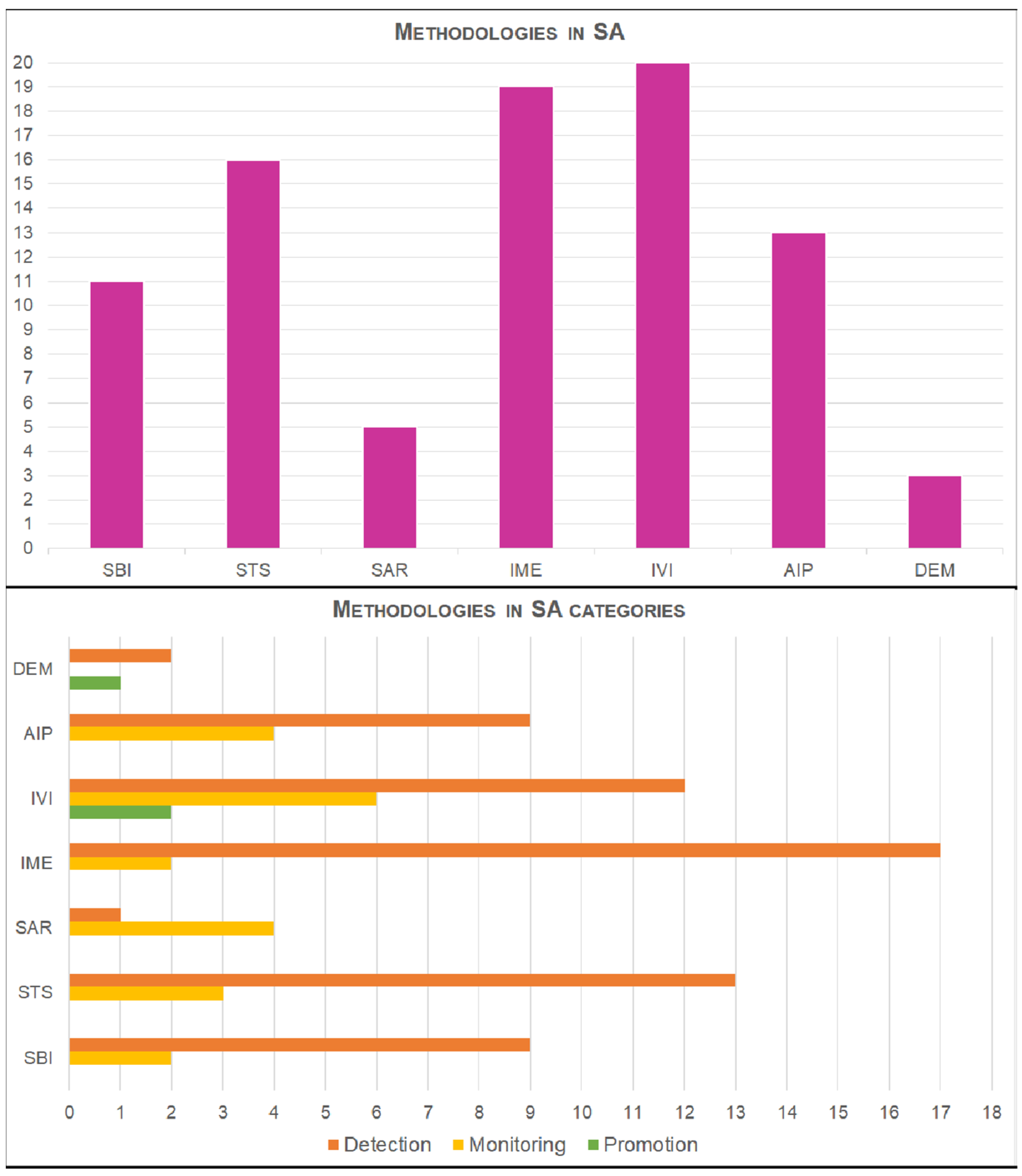
It should be noted that methodologies, such as multi-temporal change detection, mapping of sites, and data fusion are applied complementarily to most of the methodologies described above; therefore, they are not included in any cluster. Figure 4 shows that (i) IVI and IME are the most applied methodologies in their respective clusters (appearing in 20 and 19 SA works, respectively), mainly for detection purposes and less for monitoring; (ii) SAR and DEM are the least applied methodologies in their respective clusters (appearing in 5 and 3 SA works, respectively); (iii) SAR is the only methodology cluster to be applied more for monitoring than for detection; (iv) IVI is the only methodology cluster to be applied in all SA categories.
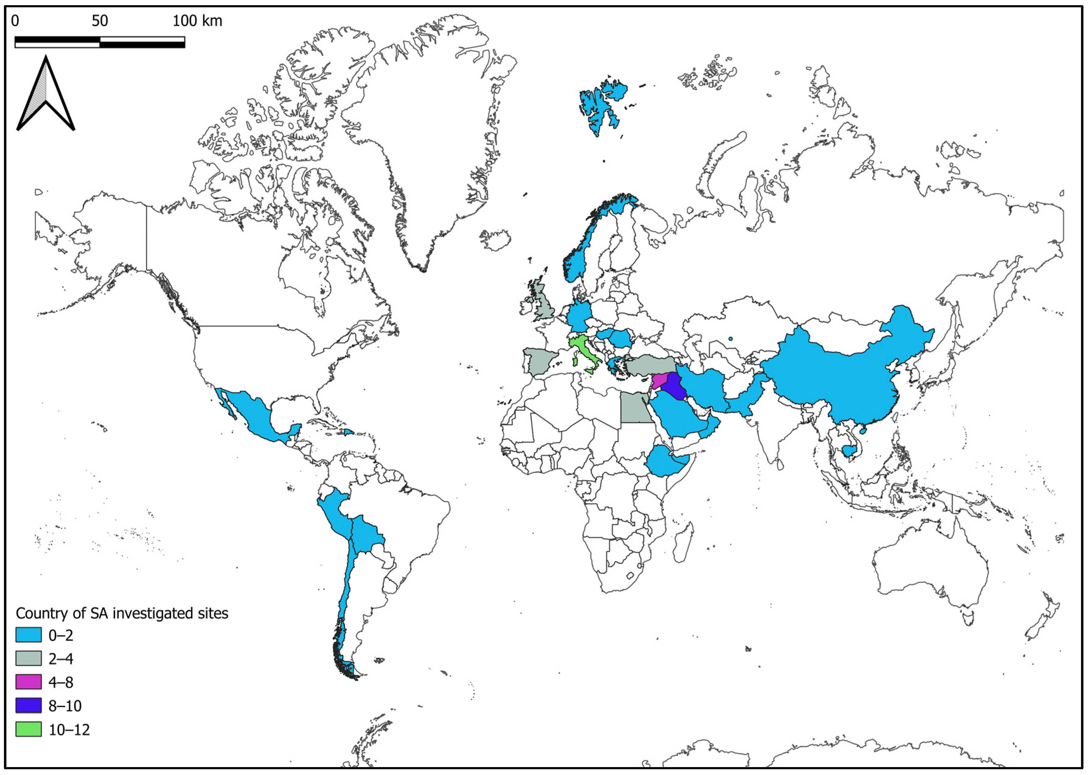
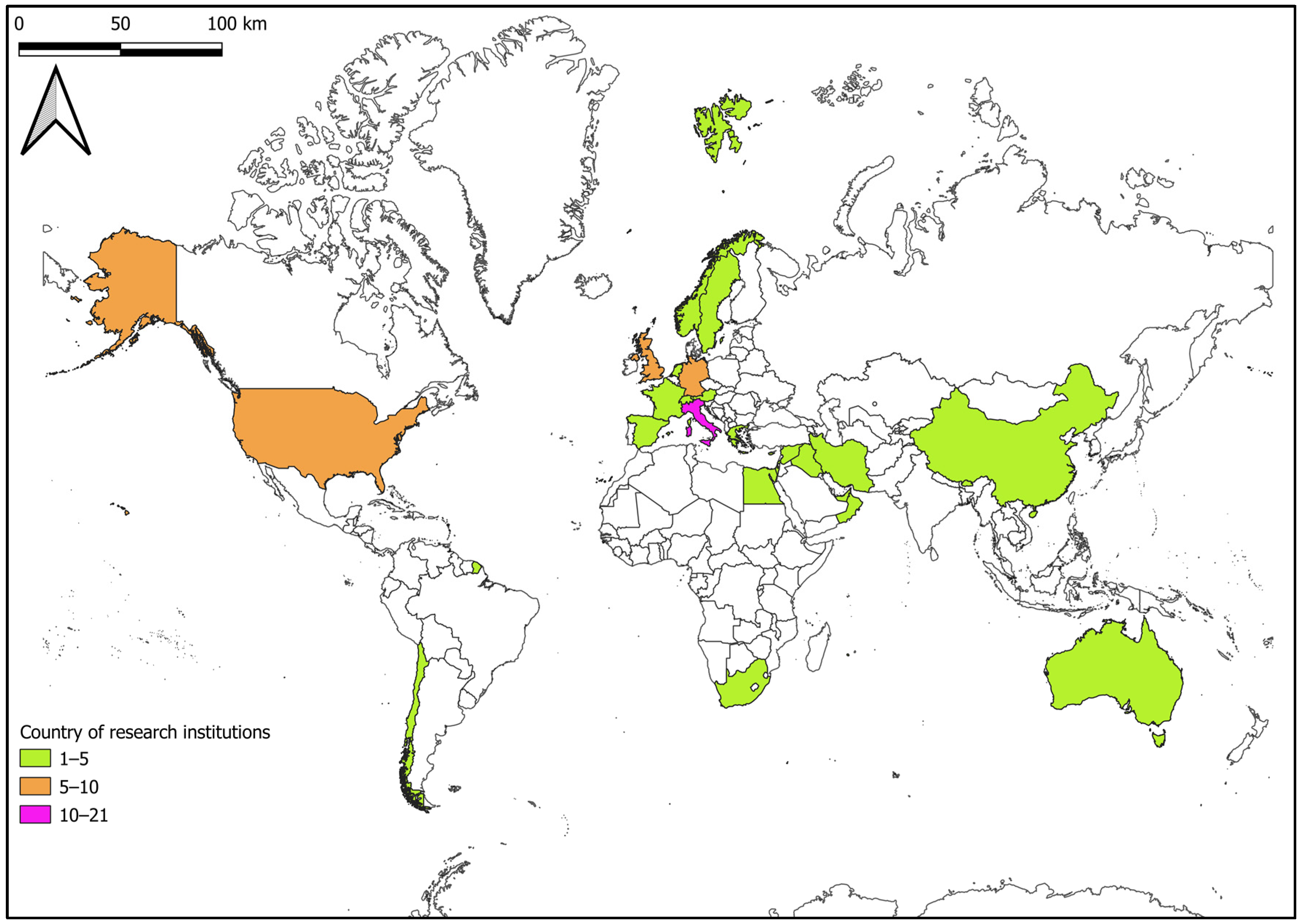
Figure 5 and Figure 6 provide visual representations of the countries that are most actively involved in SA studies. These figures use different colors to show the countries where more archaeological sites have been investigated (Figure 5) and where more research institutes with SA working groups are located (Figure 6). The Mediterranean and the Middle East are the study areas where the most investigated sites are located, and Italy has the largest number of investigated sites. The countries with the most research institutes and working groups on SA are Italy, the UK, Germany, and the USA.

4. Discussion

The analysis of the SA scientific literature sample reviewed in this study reveals a significant increase in the application of satellite data and methodologies in archaeology in recent decades (2006–2022, as indicated in Supplementary Materials). The growing use of a diverse range of space techniques and methods in archaeological investigations demonstrates an increased awareness of the potential of satellite remote sensing. However, it appears that this awareness is not reflected across all application fields. The majority of SA projects and studies focus on detecting archaeological sites (at various spatial and temporal scales) and exploring the associated contexts of environmental and anthropic dynamics. This is likely due to the higher readability and accessibility of optical images and their relative larger datasets compared to SAR data, as illustrated in Figure 1, Figure 2 and Figure 3. The detection category represents the application field that best illustrates the evolution of SA, as evidenced by the broader experimentation of satellite data analysis and processing methodologies. This is supported by the widespread use of all the various SA methodologies for detection, with visual inspection and image enhancement (as depicted in Figure 4) being the most frequently employed. This is likely due to the general preference for optical data.
On the other hand, while the monitoring application field is less targeted than detection, it shows advancement in the integration of SAR data and techniques, resulting in almost exclusive exploitation of SAR methodologies in this SA category (Figure 4). The current overview reveals that more and more SA works are utilizing the potential of these technologies to monitor the stability of archaeological heritage exposed to geo-hazards, such as landslides, earthquakes, subsidence, etc., while optical data continue to be used for observing and detecting changes and looting in archaeological sites. Therefore, the trend to experiment with all types of satellite data and techniques found in detection corresponds to the selection of satellite data and techniques based on their suitability for the investigation context in monitoring.
The weak application of satellite data and techniques in promoting archaeological heritage, as inferred from the review (Figure 1), could be related to the sample examined here (in relation to both the amount and the type—scientific paper, reports and books—of SA works selected) or to an overall smaller number of archaeology studies addressing this application field. Similarly, it is necessary to reflect on the methodologies applied in the promotion category (Figure 4), noting how visual interpretation of the archaeological site context is strongly supported by satellite data (optical images and DEM). Therefore, this analysis highlights a current limitation of SA, where works could make greater use of the potential of satellite remote sensing to disseminate knowledge of archaeological heritage and address a global audience.
The critical review presented here provides an overview of the current state of SA concepts and approaches in various application fields. It reveals progress in detection, an evolving awareness in monitoring, and a gap that needs to be addressed in promotion. Additionally, the analysis suggests that a common approach in all SA works examined is the combination of data and integration of methodologies, indicating a growing propensity to explore and apply sources and tools from various disciplinary fields. SA is increasingly using software and cloud computing platforms for image processing, advanced statistical methods, and even artificial intelligence algorithms, paving the way for new development perspectives in this interdisciplinary field. The rising interest in SA investigations is reflected in the growing number of interdisciplinary research groups focusing on SA in every continent, with a greater concentration in Europe and the USA (Figure 6). However, the map of countries where the investigated archaeological sites are located (Figure 5) reveals that the choice of sites falls approximately in the same areas, possibly due to the greater legibility of the context from satellite and less accessibility on the ground, or even due to a larger presence of sites in these areas. Nevertheless, it should be considered that the spatial distribution of sites and research institutions involved in SA works is partly conditioned by the sample examined herein, which, although representative, may overlook some of the scientific literature written in local languages.
The knowledge exchange between archaeological and satellite remote sensing sciences involves not only the fusion of data, methods, and approaches and collaborations in specialist networks, but also the acquisition of cross-cutting competencies that can help in innovating archaeological disciplines in all application fields by playing a key role in new scientific frontiers [4]. SA can contribute to achieving the target within Sustainable Development Goal 11 [94], which aims to safeguard the world cultural heritage, and can fit among the sciences that are now engaged in transforming satellite technologies into an economic resource that solves humanity’s complex problems in a common challenge, such as the new space economy [95]. Both archaeologists and satellite remote sensing scientists are accustomed to observing the Earth’s surface in the present and reconstructing the past from a perspective. SA today is the science that must be able to look and work in perspective toward the future by perceiving the interacting factors of critical conditions, such as the effects of climate change and providing the tools for enacting a cultural as well as a natural revolution [2].
This review highlights the strengths and weaknesses of SA in the current scenario by providing a new point of view that focuses on application fields and connects SA with a wider context of sciences. The main advantage of this new review study is the analytical approach that allows us to describe the advancement of SA rather than qualitatively discussing principles, methods, and techniques. However, it should be noted that a sample of a wider scientific literature was considered, which, although representative, might have affected the review.

5. Conclusions

This work provides a brief holistic review of the concepts and approaches of SA in different application fields, including detection, monitoring, and promotion of archaeological heritage. The analysis of 52 SA studies was applied through a quantitative approach that represents an innovative review method in SA scenery.
This new methodology allows us to find that the majority of SA studies aim to detect archaeological sites and contexts by experimenting with satellite data and methods. Furthermore, the analysis shows that optical data are typically used more than SAR data, which is more commonly applied in monitoring archaeological sites. Then, image enhancement and visual interpretation methodologies are more frequently employed than other data processing methods. Moreover, the visual representation of countries involved in SA works suggests that interdisciplinary research teams are exploring SA in every continent, with a higher concentration in Europe and the USA. The sites investigated tend to be located in areas, such as the Mediterranean and Middle East.
The present brief review proves that the innovative growth of SA has positioned it as a driver for cross-skills training, as well as a promising future science capable of playing a key role in the frontier of sustainable development and the new space economy.

Supplementary Materials

The following supporting information can be downloaded at: https://www.mdpi.com/article/10.3390/rs15123049/s1.

Author Contributions

Conceptualization, M.Z., G.S. and D.C.; methodology, M.Z.; writing—original draft preparation, M.Z., G.S. and D.C.; writing—review and editing, M.Z.; supervision, D.C. All authors have read and agreed to the published version of the manuscript.

Funding

The present work was developed within RIPARTI project supported by the program POC PUGLIA FESRT-FSE 2014/2020, Azione 10.4 (scientific coordinator Domenico Capolongo).

Data Availability Statement

All data are contained in the article.

Conflicts of Interest

The authors declare no conflict of interest.

References

  1. Parcak, S.H. GIS, remote sensing, and landscape archaeology. In The Oxford Handbook of Topics in Archaeology; Oxford Academic: Oxford, UK, 2014. [Google Scholar]
  2. Parcak, S. Archaeology from Space: How the Future Shapes Our Past; Henry Holt and Company: New York, NY, USA, 2019. [Google Scholar]
  3. Tapete, D. Remote Sensing and Geosciences for Archaeology. Geosciences 2018, 8, 41. [Google Scholar] [CrossRef] [Green Version]
  4. Luo, L.; Wang, X.; Guo, H.; Jia, X.; Fan, A. Earth observation in archaeology: A brief review. Int. J. Appl. Earth Obs. Geoinf. 2023, 116, 103169. [Google Scholar] [CrossRef]
  5. Forte, M.; Campana, S.; Liuzza, C. (Eds.) Space, Time, Place; Archaeopress: Oxford, UK, 2010. [Google Scholar]
  6. Orlando, P.; Villa, B.D. Remote sensing applications in archaeology. Archeol. E Calc. 2011, 22, 147–168. [Google Scholar]
  7. Luo, L.; Wang, X.; Guo, H.; Lasaponara, R.; Zong, X.; Masini, N.; Wang, G.; Shi, P.; Khatteli, H.; Chen, F.; et al. Airborne and spaceborne remote sensing for archaeological and cultural heritage applications: A review of the century (1907–2017). Remote Sens. Environ. 2019, 232, 111280. [Google Scholar] [CrossRef]
  8. Traviglia, A.; Torsello, A. Landscape Pattern Detection in Archaeological Remote Sensing. Geosciences 2017, 7, 128. [Google Scholar] [CrossRef] [Green Version]
  9. Frodella, W.; Elashvili, M.; Spizzichino, D.; Gigli, G.; Adikashvili, L.; Vacheishvili, N.; Kirkitadze, G.; Nadaraia, A.; Margottini, C.; Casagli, N. Combining InfraRed Thermography and UAV Digital Photogrammetry for the Protection and Conservation of Rupestrian Cultural Heritage Sites in Georgia: A Methodological Application. Remote Sens. 2020, 12, 892. [Google Scholar] [CrossRef] [Green Version]
  10. Czajlik, Z.; Árvai, M.; Mészáros, J.; Nagy, B.; Rupnik, L.; Pásztor, L. Cropmarks in Aerial Archaeology: New Lessons from an Old Story. Remote Sens. 2021, 13, 1126. [Google Scholar] [CrossRef]
  11. De Angeli, S.; Battistin, F. Archaeological site monitoring and risk assessment using remote sensing technologies and GIS. In A Research Agenda for Heritage Planning: Perspectives from Europe; Edward Elgar Publishing: Cheltenham, UK, 2021; Chapter 12; p. 145. [Google Scholar] [CrossRef]
  12. Drap, P.; Papini, O.; Pruno, E.; Nucciotti, M.; Vannini, G. Ontology-Based Photogrammetry Survey for Medieval Archaeology: Toward a 3D Geographic Information System (GIS). Geosciences 2017, 7, 93. [Google Scholar] [CrossRef] [Green Version]
  13. Verhoeven, G.J. Are We There Yet? A Review and Assessment of Archaeological Passive Airborne Optical Imaging Approaches in the Light of Landscape Archaeology. Geosciences 2017, 7, 86. [Google Scholar] [CrossRef] [Green Version]
  14. Bucci, G. Remote Sensing and Geo-Archaeological Data: Inland water studies for the conservation of underwater cultural heritage in the Ferrara District, Italy. Remote Sens. 2018, 10, 380. [Google Scholar] [CrossRef] [Green Version]
  15. Thompson, V.D.; DePratter, C.B.; Lulewicz, J.; Lulewicz, I.H.; Roberts Thompson, A.D.; Cramb, J.; Ritchison, B.T.; Colvin, M.H. The Archaeology and Remote Sensing of Santa Elena’s Four Millennia of Occupation. Remote Sens. 2018, 10, 248. [Google Scholar] [CrossRef] [Green Version]
  16. Guyot, A.; Lennon, M.; Thomas, N.; Gueguen, S.; Petit, T.; Lorho, T.; Cassen, S.; Hubert-Moy, L. Airborne Hyperspectral Imaging for Submerged Archaeological Mapping in Shallow Water Environments. Remote Sens. 2019, 11, 2237. [Google Scholar] [CrossRef] [Green Version]
  17. Lambers, K.; Verschoof-van der Vaart, W.B.; Bourgeois, Q.P.J. Integrating Remote Sensing, Machine Learning, and Citizen Science in Dutch Archaeological Prospection. Remote Sens. 2019, 11, 794. [Google Scholar] [CrossRef] [Green Version]
  18. Rączkowski, W. Power and/or Penury of Visualizations: Some Thoughts on Remote Sensing Data and Products in Archaeology. Remote Sens. 2020, 12, 2996. [Google Scholar] [CrossRef]
  19. Brooke, C.; Clutterbuck, B. Mapping Heterogeneous Buried Archaeological Features Using Multisensor Data from Unmanned Aerial Vehicles. Remote Sens. 2020, 12, 41. [Google Scholar] [CrossRef] [Green Version]
  20. Altaweel, M.; Khelifi, A.; Li, Z.; Squitieri, A.; Basmaji, T.; Ghazal, M. Automated Archaeological Feature Detection Using Deep Learning on Optical UAV Imagery: Preliminary Results. Remote Sens. 2022, 14, 553. [Google Scholar] [CrossRef]
  21. Masini, N.; Abate, N.; Gizzi, F.T.; Vitale, V.; Amodio, A.M.; Sileo, M.; Biscione, M.; Lasaponara, R.; Bentivenga, M.; Cavalcante, F. UAV LiDAR Based Approach for the Detection and Interpretation of Archaeological Micro Topography under Canopy—The Rediscovery of Perticara (Basilicata, Italy). Remote Sens. 2022, 14, 6074. [Google Scholar] [CrossRef]
  22. Lasaponara, R.; Masini, N. Remote Sensing in Archaeology: From Visual Data Interpretation to Digital Data Manipulation. In Satellite Remote Sensing: A New Tool for Archaeology; Springer: Berlin/Heidelberg, Germany, 2012; pp. 3–16. [Google Scholar] [CrossRef]
  23. Cowley, D.; Verhoeven, G.; Traviglia, A. Editorial for Special Issue: “Archaeological Remote Sensing in the 21st Century: (Re)Defining Practice and Theory”. Remote Sens. 2021, 13, 1431. [Google Scholar] [CrossRef]
  24. Zingaro, A. Advanced analysis and integration of Remote Sensing and in situ data for flood monitoring. Rendiconti Online della Soc. Geol. Ital. 2021, 54, 41–47. [Google Scholar] [CrossRef]
  25. Fowler, J.M. Satellite imagery and archaeology. In Landscapes through the Lens: Aerial Photographs and Historic Environment; Cowley, D.C., Standring, R.A., Abicht, M.J., Eds.; Oxbow Books: Oxford, UK, 2010; Chapter 10; pp. 99–110. [Google Scholar]
  26. Campana, S. Le immagini da satellite nell’indagine archeologica: Stato dell’arte, casi di studio, prospettive. Archeologia Aerea. Studi Aerotopogr. Archeol. 2004, 1, 279–299. [Google Scholar]
  27. Hanson, W.S.; Oltean, I.A. Archaeology from Historical Aerial and Satellite Archives; Springer: New York, NY, USA, 2013. [Google Scholar]
  28. Lasaponara, R.; Masini, N. Satellite Synthetic Aperture Radar in Archaeology and Cultural Landscape: An Overview. Archaeol. Prospect. 2013, 20, 71–78. [Google Scholar] [CrossRef]
  29. Luo, L.; Wang, X.; Guo, H.; Lasaponara, R.; Shi, P.; Bachagha, N.; Li, L.; Yao, Y.; Masini, N.; Chen, F.; et al. Google Earth as a Powerful Tool for Archaeological and Cultural Heritage Applications: A Review. Remote Sens. 2018, 10, 1558. [Google Scholar] [CrossRef]
  30. Zingaro, M.; La Salandra, M.; Colacicco, R.; Roseto, R.; Petio, P.; Capolongo, D. Suitability assessment of global, continental and national digital elevation models for geomorphological analyses in Italy. Trans. GIS 2021, 25, 2283–2308. [Google Scholar] [CrossRef]
  31. Campana, S.; Francovich, R. Landscape Archaeology in Tuscany: Cultural resource management, remotely sensed techniques, GIS based data integration and interpretation. Bar Int. Ser. 2003, 1151, 15–28. [Google Scholar]
  32. Chyla, J.M. How Can Remote Sensing Help in Detecting the Threats to Archaeological Sites in Upper Egypt? Geosciences 2017, 7, 97. [Google Scholar] [CrossRef] [Green Version]
  33. Comer, D.C.; Chapman, B.D.; Comer, J.A. Detecting Landscape Disturbance at the Nasca Lines Using SAR Data Collected from Airborne and Satellite Platforms. Geosciences 2017, 7, 106. [Google Scholar] [CrossRef] [Green Version]
  34. Zingaro, M.; Mastronuzzi, G. Il popolamento antico di Lama Diumo-San Giorgio in relazione alle forme del paesaggio. Agric. Centuriati. 2017, 14, 39–56. [Google Scholar] [CrossRef]
  35. Zingaro, M. Evoluzione storica del popolamento antico in agro di Andria (Puglia). J. Anc. Topogr. 2018, 28, 95–104. [Google Scholar]
  36. Zingaro, M. Forme del paesaggio e sistema viario. Il ruolo di Monte Sannace nelle dinamiche territoriali della Puglia centrale. In Monte Sannace Lavori in Corso; Palmentola, P., Ed.; Studi e Ricerche presso il Parco Archeologico di Monte Sannace: Gioia del Colle, Italy, 2022; pp. 15–24. [Google Scholar]
  37. Brancato, R. How to access ancient landscapes? Field survey and legacy data integration for research on Greek and Roman settlement patterns in Eastern Sicily. Groma Doc. Archaeol. 2020, 4, 1–32. [Google Scholar] [CrossRef]
  38. Giardino, M.J. NASA Remote Sensing and Archaeology. In Satellite Remote Sensing: A New Tool for Archaeology, Remote Sensing and Digital Image Processing; Lasaponara, R., Masini, N., Eds.; Springer: Berlin/Heidelberg, Germany, 2012; Volume 16, pp. 157–176. [Google Scholar]
  39. Bonazza, A.; Bonora, N.; Duke, B.; Spizzichino, D.; Recchia, A.P.; Taramelli, A. Copernicus in Support of Monitoring, Protection, and Management of Cultural and Natural Heritage. Sustainability 2022, 14, 2501. [Google Scholar] [CrossRef]
  40. Comer, D.C.; Harrower, M.J. Mapping Archaeological Landscapes from Space; Springer: New York, NY, USA, 2013; Volume 5, pp. 159–171. [Google Scholar]
  41. Golinelli, G.M.; Gaetano, M. Cultural Heritage and Value Creation; Sprienger Briefs in Economics; Springer: Cham, Switzerland, 2015. [Google Scholar]
  42. Aminzadeh, B.; Samani, F. Identifying the boundaries of the historical site of Persepolis using remote sensing. Remote Sens. Environ. 2006, 102, 52–62. [Google Scholar] [CrossRef]
  43. Lasaponara, R.; Masini, N. Detection of archaeological crop marks by using satellite QuickBird multispectral 477 imagery. J. Archaeol. Sci. 2007, 34, 214–221. [Google Scholar] [CrossRef]
  44. Oltean, I.A.; Abell, L.L. High-Resolution Satellite Imagery and the Detection of Buried Archaeological Features in Ploughed Landscapes. In Satellite Remote Sensing: A New Tool for Archaeology; Springer: Berlin/Heidelberg, Germany, 2011; pp. 291–305. [Google Scholar] [CrossRef]
  45. Agapiou, A.; Alexakis, D.D.; Sarris, A.; Hadjimitsis, D.G. Orthogonal equations of multi-spectral satellite imagery for the identification of un-excavated archaeological sites. Remote Sens. 2013, 5, 6560–6586. [Google Scholar] [CrossRef] [Green Version]
  46. Agapiou, A.; Lysandrou, V.; Lasaponara, R.; Masini, N.; Hadjimitsis, D.G. Study of the Variations of Archaeological Marks at Neolithic Site of Lucera, Italy Using High-Resolution Multispectral Datasets. Remote Sens. 2016, 8, 723. [Google Scholar] [CrossRef] [Green Version]
  47. Abate, N.; Roubis, D.; Vitale, V.; Sileo, M.; Sogliani, F.; Masini, N.; Lasaponara, R. Integrated use of multi-temporal multi-sensor and multiscale Remote Sensing data for the understanding of archaeological contexts: The case study of Metaponto, Basilicata. J. Phys. Conf. Ser. 2022, 2204, 012020. [Google Scholar] [CrossRef]
  48. Agapiou, A.; Lysandrou, V.; Sarris, A.; Papadopoulos, N.; Hadjimitsis, D.G. Fusion of Satellite Multispectral Images Based on Ground-Penetrating Radar (GPR) Data for the Investigation of Buried Concealed Archaeological Remains. Geosciences 2017, 7, 40. [Google Scholar] [CrossRef] [Green Version]
  49. Sonnemann, T.F.; Comer, D.C.; Patsolic, J.L.; Megarry, W.P.; Malatesta, E.H.; Hofman, C.L. Semi-Automatic Detection of Indigenous Settlement Features on Hispaniola through Remote Sensing Data. Geosciences 2017, 7, 127. [Google Scholar] [CrossRef] [Green Version]
  50. Kalayci, T.; Lasaponara, R.; Wainwright, J.; Masini, N. Multispectral Contrast of Archaeological Features: A Quantitative Evaluation. Remote Sens. 2019, 11, 913. [Google Scholar] [CrossRef] [Green Version]
  51. Titolo, A. Use of Time-Series NDWI to Monitor Emerging Archaeological Sites: Case Studies from Iraqi Artificial Reservoirs. Remote Sens. 2021, 13, 786. [Google Scholar] [CrossRef]
  52. Noviello, M.; Ciminale, M.; De Pasquale, V. Combined application of pansharpening and enhancement methods to improve archaeological cropmark visibility and identification in QuickBird imagery: Two case studies from Apulia, Southern Italy. J. Archaeol. Sci. 2013, 40, 3604–3613. [Google Scholar] [CrossRef]
  53. Lasaponara, R.; Leucci, G.; Masini, N.; Persico, R.; Scardozzi, G. Towards an operative use of remote sensing for exploring the past using satellite data: The case study of Hierapolis (Turkey). Remote Sens. Environ. 2016, 174, 148–164. [Google Scholar] [CrossRef] [Green Version]
  54. Borie, C.; Parcero-Oubiña, C.; Kwon, Y.; Salazar, D.; Flores, C.; Olguín, L.; Andrade, P. Beyond Site Detection: The Role of Satellite Remote Sensing in Analysing Archaeological Problems. A Case Study in Lithic Resource Procurement in the Atacama Desert, Northern Chile. Remote Sens. 2019, 11, 869. [Google Scholar] [CrossRef] [Green Version]
  55. Orengo, H.A.; Conesa, F.C.; Garcia-Molsosa, A.; Lobo, A.; Green, A.S.; Madella, M.; Petrie, C.A. Automated detection of archaeological mounds using machine-learning classification of multisensor and multitemporal satellite data. Proc. Natl. Acad. Sci. USA 2020, 117, 18240–18250. [Google Scholar] [CrossRef]
  56. Spizzichino, D.; Margottini, C.; Brustia, E.; Cigna, F.; Comerci, V.; Dessì, B.; Guerrieri, L.; Iadanza, C.; Leoni, G.; Vittori, E.; et al. Satellite monitoring applied to natural hazards and cultural heritage: The PROTHEGO project. In Proceedings of the Workshop Tematico di Telerilevamento—AIT Bologna, Bologna, Italy, 27–28 June 2017; Volume 27, p. 1. [Google Scholar]
  57. Themistocleous, K.; Danezis, C.; Mendonidis, E.; Lymperopoulou, E. 2017. Monitoring ground deformation of cultural heritage sites using UAVs and geodetic techniques: The case study of Choirokoitia, JPI PROTHEGO project. In Earth Resources and Environmental Remote Sensing/GIS Applications VIII; SPIE: Bellingham, WA, USA, 2017; Volume 10428, pp. 219–228. [Google Scholar] [CrossRef]
  58. Stewart, C.; Oren, E.D.; Cohen-Sasson, E. Satellite Remote Sensing Analysis of the Qasrawet Archaeological Site in North Sinai. Remote. Sens. 2018, 10, 1090. [Google Scholar] [CrossRef] [Green Version]
  59. Leoni, G.; Spizzichino, D.; Marcelli, M.; Carta, C. Il monitoraggio satellitare nelle aree archeologiche: Il caso delle Mura Aureliane di Roma. In Monitoraggio e Manutenzione delle Aree Archeologiche, Cambiamenti Climatici, Dissesto Idrogeologico, Degrado Chimico-Ambientale, Proceedings of the atti del Convegno Internazionale di Studi, Roma, Italy, 20–21 March 2019; Russo, A., Giovampaola, I.D., Eds.; L’Erma di Bretschneider: Rome, Italy, 2020; pp. 217–221. [Google Scholar]
  60. Spizzichino, D.; Margottini, C. Satellite monitoring of geo-hazards affecting cultural heritage. In A Research Agenda for Heritage Planning: Perspectives from Europe; Edward Elgar Publishing: Cheltenham, UK, 2021; p. 133. [Google Scholar] [CrossRef]
  61. Beck, A.; Philip, G.; Abdulkarim, M.; Donoghue, D. Evaluation of Corona and Ikonos high resolution satellite imagery for archaeological prospection in western Syria. Antiquity 2007, 81, 161–175. [Google Scholar] [CrossRef] [Green Version]
  62. Ciminale, M.; Gallo, D.; Lasaponara, R.; Masini, N. A multiscale approach for reconstructing archaeological landscapes: Applications in Northern Apulia (Italy). Archaeol. Prospect. 2009, 16, 143–153. [Google Scholar] [CrossRef]
  63. Trier, D.; Larsen, S.; Solberg, R. Automatic detection of circular structures in high-resolution satellite images of agricultural land. Archaeol. Prospect. 2009, 16, 1–15. [Google Scholar] [CrossRef]
  64. Lasaponara, R.; Masini, N. Beyond modern landscape features: New insights in the archaeological area of Tiwanaku in Bolivia from satellite data. Int. J. Appl. Earth Obs. Geoinf. 2014, 26, 464–471. [Google Scholar] [CrossRef]
  65. Kalayci, T.; Simon, F.-X.; Sarris, A. A Manifold Approach for the Investigation of Early and Middle Neolithic Settlements in Thessaly, Greece. Geosciences 2017, 7, 79. [Google Scholar] [CrossRef] [Green Version]
  66. Bini, M.; Isola, I.; Zanchetta, G.; Ribolini, A.; Ciampalini, A.; Baneschi, I.; Mele, D.; D’agata, A.L. Identification of Leveled Archeological Mounds (Höyük) in the Alluvial Plain of the Ceyhan River (Southern Turkey) by Satellite Remote-Sensing Analyses. Remote Sens. 2018, 10, 241. [Google Scholar] [CrossRef] [Green Version]
  67. Tapete, D.; Cigna, F. Appraisal of Opportunities and Perspectives for the Systematic Condition Assessment of Heritage Sites with Copernicus Sentinel-2 High-Resolution Multispectral Imagery. Remote Sens. 2018, 10, 561. [Google Scholar] [CrossRef] [Green Version]
  68. Sivitskis, A.J.; Lehner, J.W.; Harrower, M.J.; Dumitru, I.A.; Paulsen, P.E.; Nathan, S.; Viete, D.R.; Al-Jabri, S.; Helwing, B.; Wiig, F.; et al. Detecting and Mapping Slag Heaps at Ancient Copper Production Sites in Oman. Remote Sens. 2019, 11, 3014. [Google Scholar] [CrossRef] [Green Version]
  69. Crutchley, S. Assessing the Utility of High-Resolution Satellite Remote Sensing for Archaeological Prospection and Mapping. In Copernicus Task Force on Cultural Heritage—Annex I Case Studies; 2020, EUSpace. Available online: https://www.copernicus.eu/en/documentation/technical-documents/technical-documentstechnical-documents (accessed on 26 May 2023).
  70. Zaina, F.; Tapete, D. Satellite-Based Methodology for Purposes of Rescue Archaeology of Cultural Heritage Threatened by Dam Construction. Remote Sens. 2022, 14, 1009. [Google Scholar] [CrossRef]
  71. Lasaponara, R.; Masini, N.; Holmgren, R.; Forsberg, Y.B. Integration of aerial and satellite remote sensing for archaeological investigations: A case study of the Etruscan site of San Giovenale. J. Geophys. Eng. 2012, 9, S26–S39. [Google Scholar] [CrossRef]
  72. Jedrzejas, T.; Przybilla, H.J. Aufbau historischer 3D-Szenarien am Beispiel der mittelalterlichen Stadt Duisburg. Photogramm. Fernerkund. Geoinf. 2009, 2009, 195–204. [Google Scholar] [CrossRef]
  73. Kennedy, D.; Bishop, M. Google earth and the archaeology of Saudi Arabia. A case study from the Jeddah area. J. Archaeol. Sci. 2011, 38, 1284–1293. [Google Scholar] [CrossRef]
  74. González-Delgado, J.A.; Martínez-Graña, A.M.; Civis, J.; Sierro, F.; Goy, J.L.; Dabrio, C.J.; Ruiz, F.; González-Regalado, M.L.; Abad, M. Virtual 3D tour of the Neogene palaeontological heritage of Huelva (Guadalquivir Basin, Spain). Environ. Earth Sci. 2015, 73, 4609–4618. [Google Scholar] [CrossRef]
  75. Sonnemann, T.F. Spatial Configurations of Water Management at an Early Angkorian Capital—Combining GPR and TerraSAR-X Data to Complement an Archaeological Map. Archaeol. Prospect. 2015, 22, 105–115. [Google Scholar] [CrossRef]
  76. Casana, J.; Laugier, E. Satellite imagery-based monitoring of archaeological site damage in the Syrian civil war. PLoS ONE 2017, 12, e0188589. [Google Scholar] [CrossRef] [Green Version]
  77. Danti, M.; Branting, S.; Penacho, S. The American Schools of Oriental Research Cultural Heritage Initiatives: Monitoring Cultural Heritage in Syria and Northern Iraq by Geospatial Imagery. Geosciences 2017, 7, 95. [Google Scholar] [CrossRef] [Green Version]
  78. Agapiou, A.; Lysandrou, V.; Hadjimitsis, D.G. Optical Remote Sensing Potentials for Looting Detection. Geosciences 2017, 7, 98. [Google Scholar] [CrossRef] [Green Version]
  79. Gade, M.; Kohlus, J.; Kost, C. SAR Imaging of Archaeological Sites on Intertidal Flats in the German Wadden Sea. Geosciences 2017, 7, 105. [Google Scholar] [CrossRef] [Green Version]
  80. Parcak, S.; Mumford, G.; Childs, C. Using Open Access Satellite Data Alongside Ground Based Remote Sensing: An Assessment, with Case Studies from Egypt’s Delta. Geosciences 2017, 7, 94. [Google Scholar] [CrossRef] [Green Version]
  81. Parcak, S. Moving from Space-Based to Ground-Based Solutions in Remote Sensing for Archaeological Heritage: A Case Study from Egypt. Remote Sens. 2017, 9, 1297. [Google Scholar] [CrossRef] [Green Version]
  82. Rutishauser, S.; Erasmi, S.; Rosenbauer, R.; Buchbach, R. SARchaeology—Detecting Palaeochannels Based on High Resolution Radar Data and Their Impact of Changes in the Settlement Pattern in Cilicia (Turkey). Geosciences 2017, 7, 109. [Google Scholar] [CrossRef] [Green Version]
  83. Luo, L.; Wang, X.; Lasaponara, R.; Xiang, B.; Zhen, J.; Zhu, L.; Yang, R.; Liu, D.; Liu, C. Auto-Extraction of Linear Archaeological Traces of Tuntian Irrigation Canals in Miran Site (China) from Gaofen-1 Satellite Imagery. Remote Sens. 2018, 10, 718. [Google Scholar] [CrossRef] [Green Version]
  84. Rayne, L.; Donoghue, D. A Remote Sensing Approach for Mapping the Development of Ancient Water Management in the Near East. Remote Sens. 2018, 10, 2042. [Google Scholar] [CrossRef] [Green Version]
  85. Jotheri, J.; de Gruchy, M.W.; Almaliki, R.; Feadha, M. Remote Sensing the Archaeological Traces of Boat Movement in the Marshes of Southern Mesopotamia. Remote Sens. 2019, 11, 2474. [Google Scholar] [CrossRef] [Green Version]
  86. McGrath, C.N.; Scott, C.; Cowley, D.; Macdonald, M. Towards a Satellite System for Archaeology? Simulation of an Optical Satellite Mission with Ideal Spatial and Temporal Resolution, Illustrated by a Case Study in Scotland. Remote Sens. 2020, 12, 4100. [Google Scholar] [CrossRef]
  87. Hesse, R. Combining Structure-from-Motion with high and intermediate resolution satellite images to document threats to archaeological heritage in arid environments. J. Cult. Herit. 2015, 16, 192–201. [Google Scholar] [CrossRef]
  88. Cerra, D.; Plank, S.; Lysandrou, V.; Tian, J. Cultural Heritage Sites in Danger—Towards Automatic Damage Detection from Space. Remote Sens. 2016, 8, 781. [Google Scholar] [CrossRef] [Green Version]
  89. Morehart, C.T.; Millhauser, J.K. Monitoring cultural landscapes from space: Evaluating archaeological sites in the Basin of Mexico using very high resolution satellite imagery. J. Archaeol. Sci. Rep. 2016, 10, 363–376. [Google Scholar] [CrossRef]
  90. Lasaponara, R.; Murgante, B.; Elfadaly, A.; Qelichi, M.M.; Shahraki, S.Z.; Wafa, O.; Attia, W. Spatial Open Data for Monitoring Risks and Preserving Archaeological Areas and Landscape: Case Studies at Kom el Shoqafa, Egypt and Shush, Iran. Sustainability 2017, 9, 572. [Google Scholar] [CrossRef] [Green Version]
  91. Luo, L.; Wang, X.; Liu, J.; Guo, H.; Zong, X.; Ji, W.; Cao, H. VHR GeoEye-1 imagery reveals an ancient water landscape at the Longcheng site, northern Chaohu Lake Basin (China). Int. J. Digit. Earth 2017, 10, 139–154. [Google Scholar] [CrossRef]
  92. Soroush, M.; Mehrtash, A.; Khazraee, E.; Ur, J.A. Deep Learning in Archaeological Remote Sensing: Automated Qanat Detection in the Kurdistan Region of Iraq. Remote Sens. 2020, 12, 500. [Google Scholar] [CrossRef] [Green Version]
  93. Malinverni, E.S.; Pierdicca, R.; Bozzi, C.A.; Colosi, F.; Orazi, R. Analysis and Processing of Nadir and Stereo VHR Pleiadés Images for 3D Mapping and Planning the Land of Nineveh, Iraqi Kurdistan. Geosciences 2017, 7, 80. [Google Scholar] [CrossRef] [Green Version]
  94. United Nations. The Sustainable Development Goals Report. 2022. Available online: https://unstats.un.org/sdgs/report/2022/The-Sustainable-Development-Goals-Report-2022.pdf (accessed on 26 May 2023).
  95. OECD. OECD Handbook on Measuring the Space Economy; OECD: Paris, France, 2012; ISBN 978-92-64-12180-5. [Google Scholar]
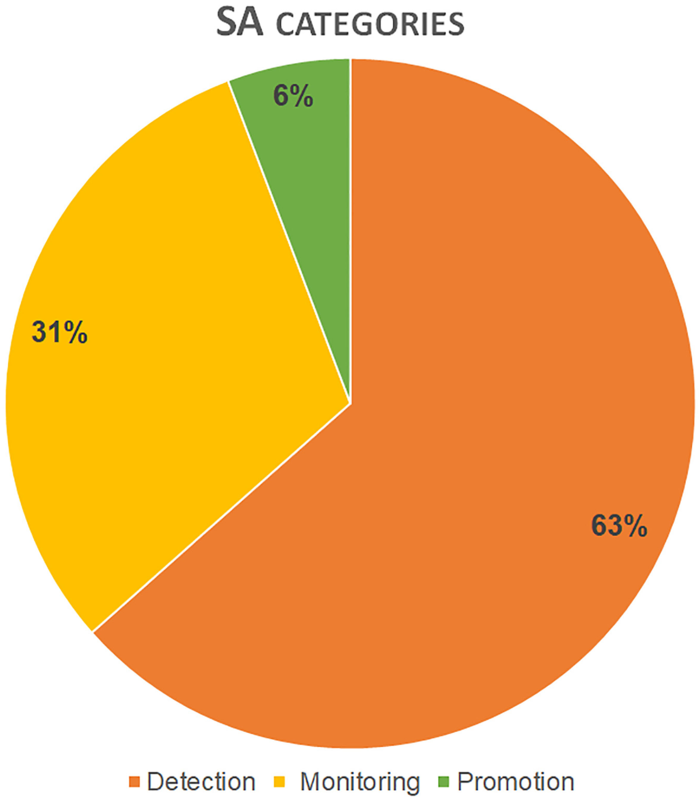
Figure 1. Classification of SA works in application field categories with corresponding distribution rate.
Remotesensing 15 03049 g001
Figure 2. Satellite optical and SAR data used in SA works: Application rate (on the left) and distribution values in SA categories (on the right).
Remotesensing 15 03049 g002
Figure 3. Satellite mission data used in SA works with corresponding application frequency values.
Remotesensing 15 03049 g003
Figure 4. Bar graph displays the frequency of application for various methodologies in SA works (located at the top), as well as their corresponding distribution in SA categories (located at the bottom). Please refer to Table 1 for the abbreviations used for the methodologies.
Remotesensing 15 03049 g004
Figure 5. Map of countries where the investigated sites are located. The different colors relate to the number of sites investigated in the country.
Remotesensing 15 03049 g005
Figure 6. Map of countries where the research institutions of SA work authors are located. Color gradient relates to the number of institutions in the country.
Remotesensing 15 03049 g006
Table 1. Methodologies applied in SA works, classified in clusters with corresponding abbreviation (name) and examples.
ClusterMethodologiesNameExamples
1Spectral band indicesSBINormalized Difference Vegetation Index (NDVI), Normalized Difference Water Index (NDWI)
2StatisticsSTSPrincipal Component Analysis (PCA), Tasseled Cap Transformation (TCT), Linear Discriminant Analysis (LDA), etc.
3SAR amplitude, interferometric coherenceSARPermanent Scatterer InSAR (PSI), Differential InSAR (DInSAR), etc.
4Image enhancementIMEFilters, band combinations, etc.
5Image visual inspectionIVIImage observation and interpretation
6Advanced algorithms of image processingAIPPattern Recognition, Segmentation, Machine/Deep learning, etc.
7Digital elevation modelsDEMStereo-pair images, Satellite Digital Elevation Models
Disclaimer/Publisher’s Note: The statements, opinions and data contained in all publications are solely those of the individual author(s) and contributor(s) and not of MDPI and/or the editor(s). MDPI and/or the editor(s) disclaim responsibility for any injury to people or property resulting from any ideas, methods, instructions or products referred to in the content.