
Quantifying Multi-Source Uncertainties in GRACE-Based Estimates of Groundwater Storage Changes in Mainland China


Abstract
1. Introduction
2. Study Area and Datasets
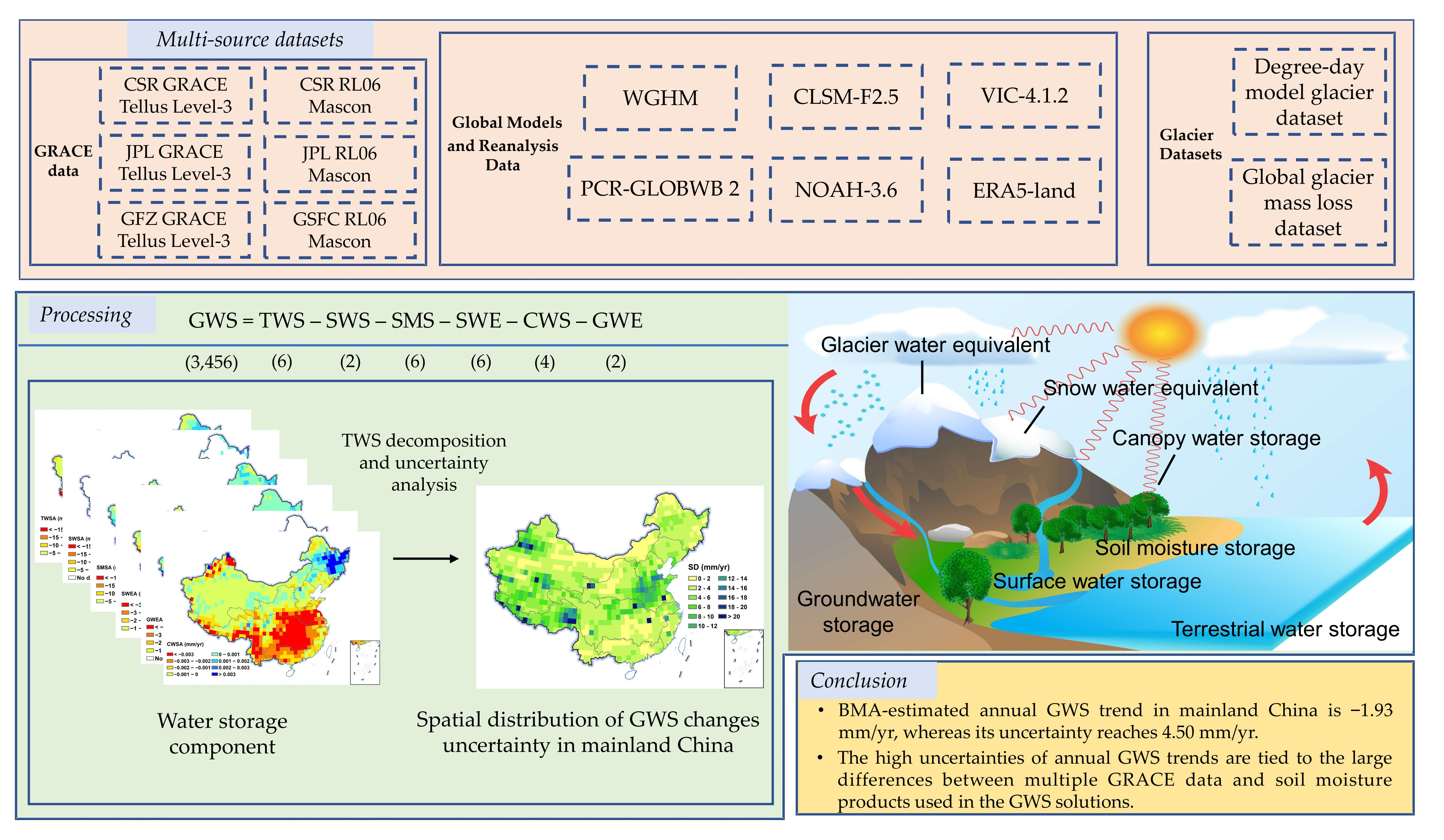
2.1. Study Area
2.2. Datasets
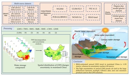
2.2.1. GRACE Data
2.2.2. Global Models and Reanalysis Data
2.2.3. Glacier Datasets
3. Methods
3.1. GRACE-Based Estimation of GWS Changes
3.2. Performance Metrics for Quantifying the Uncertainties of GWS Estimation
3.3. Merging GWS Changes Based on BMA
4. Results and Discussion
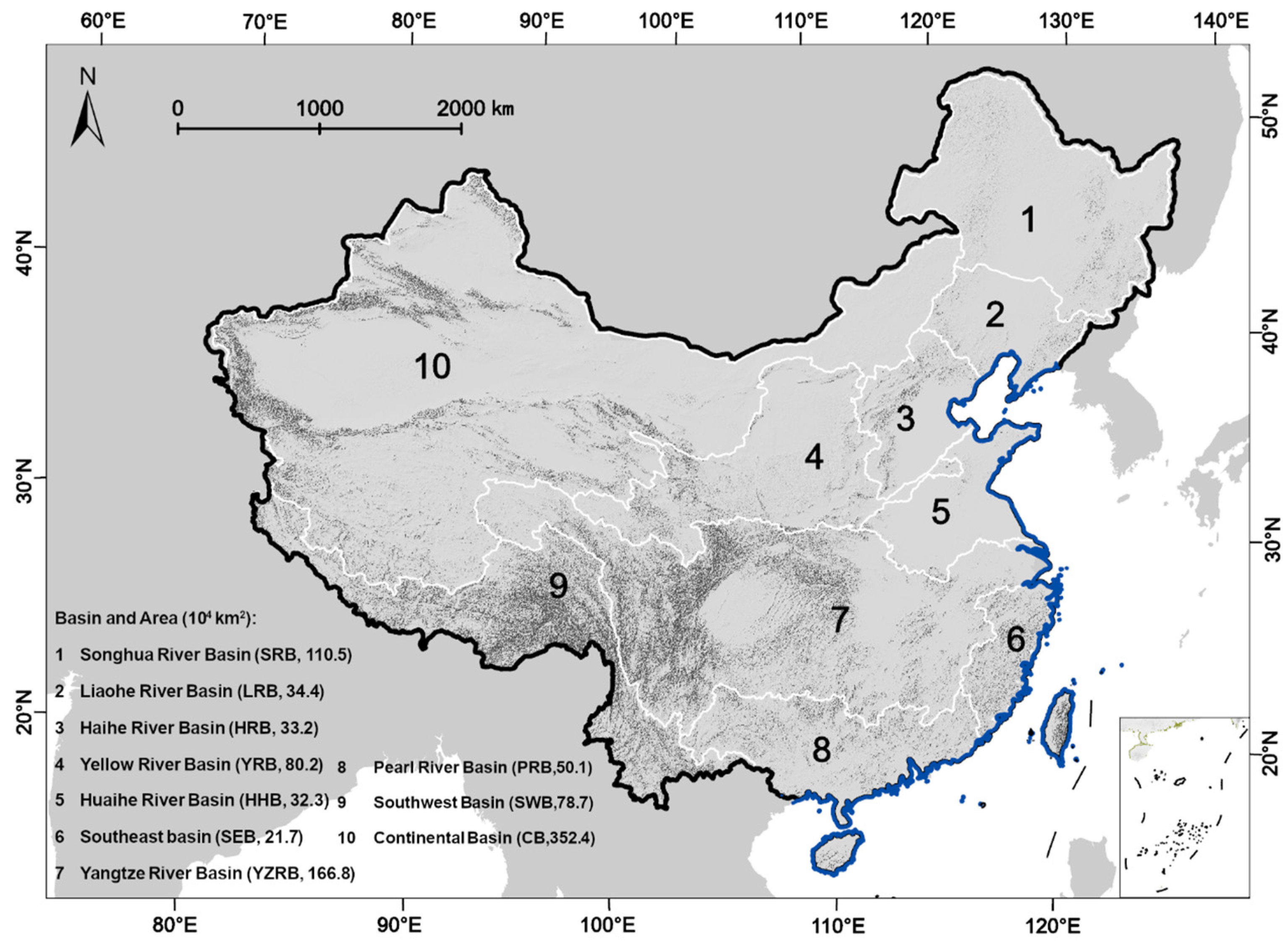
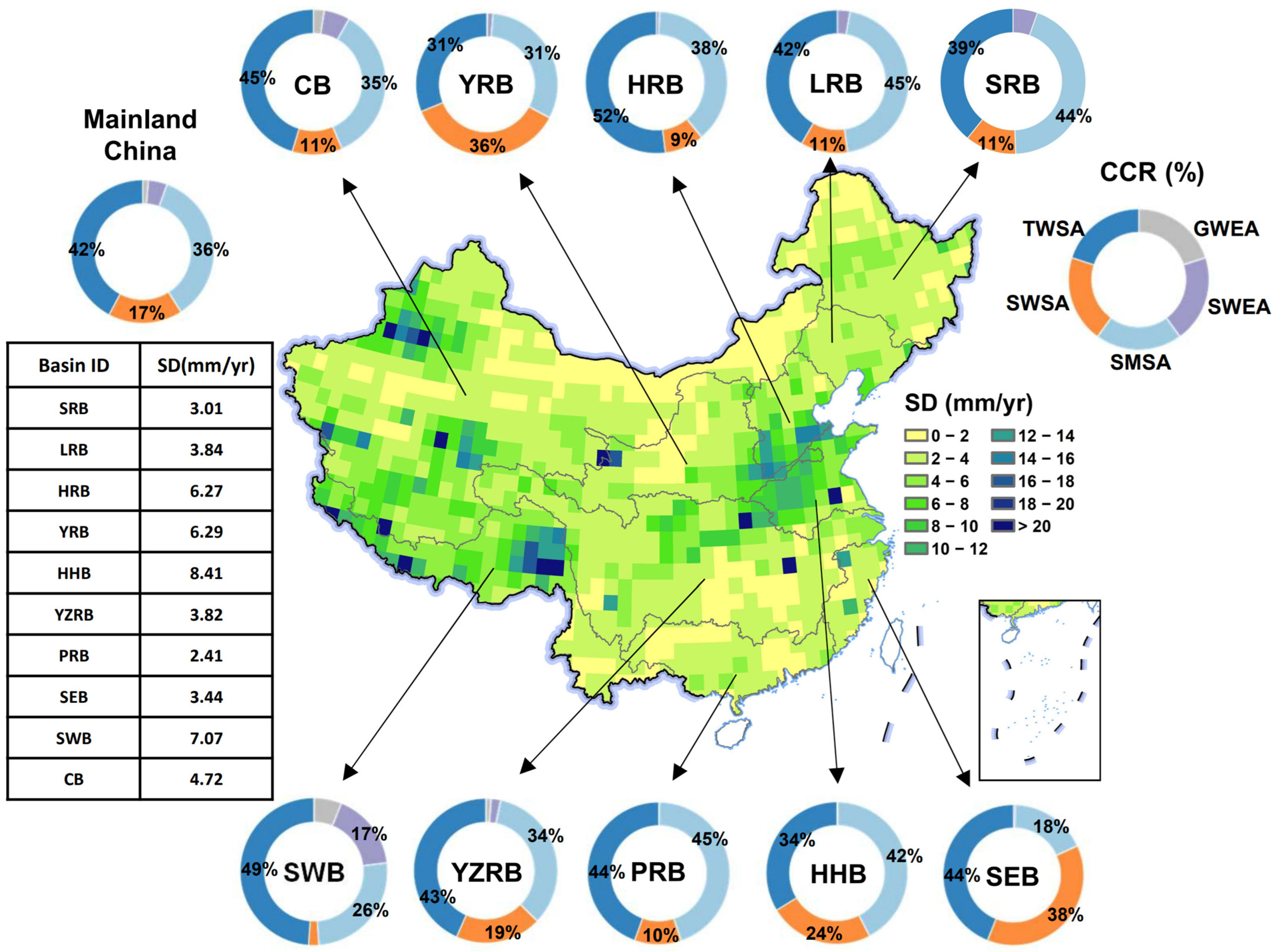
4.1. Uncertainty Estimation of TWS and Non-GWS Component Changes
4.2. Estimation of Multi-Source Uncertainties in GRACE-Based GWS Changes
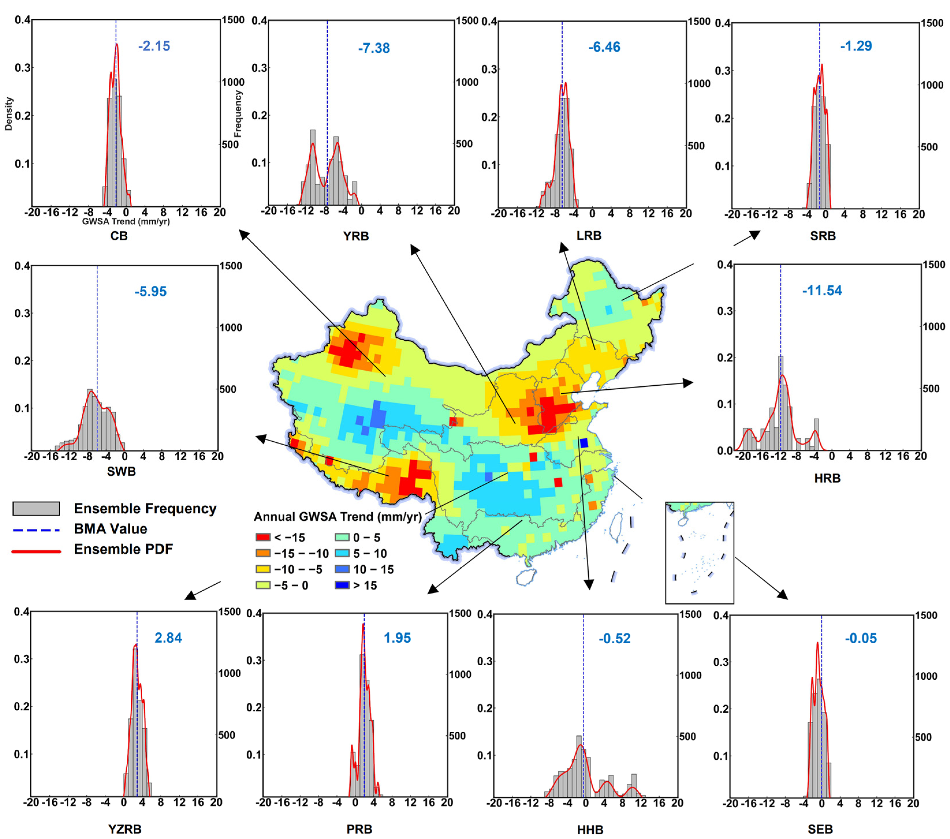
4.3. BMA-Based Estimation of GWS Changes under Uncertainty Framework
5. Conclusions
Supplementary Materials
Author Contributions
Funding
Data Availability Statement
Acknowledgments
Conflicts of Interest
References
- Aeschbach-Hertig, W.; Gleeson, T. Regional Strategies for the Accelerating Global Problem of Groundwater Depletion. Nat. Geosci. 2012, 5, 853–861. [Google Scholar] [CrossRef]
- Dangar, S.; Asoka, A.; Mishra, V. Causes and Implications of Groundwater Depletion in India: A Review. J. Hydrol. 2021, 596, 126103. [Google Scholar] [CrossRef]
- Diffenbaugh, N.S.; Swain, D.L.; Touma, D. Anthropogenic Warming Has Increased Drought Risk in California. Proc. Natl. Acad. Sci. USA 2015, 112, 3931–3936. [Google Scholar] [CrossRef] [PubMed]
- Le Brocque, A.F.; Kath, J.; Reardon-Smith, K. Chronic Groundwater Decline: A Multi-Decadal Analysis of Groundwater Trends under Extreme Climate Cycles. J. Hydrol. 2018, 561, 976–986. [Google Scholar] [CrossRef]
- Scanlon, B.R.; Duncan, I.; Reedy, R.C. Drought and the Water–Energy Nexus in Texas. Environ. Res. Lett. 2013, 8, 045033. [Google Scholar] [CrossRef]
- Rodell, M.; Velicogna, I.; Famiglietti, J.S. Satellite-Based Estimates of Groundwater Depletion in India. Nature 2009, 460, 999–1002. [Google Scholar] [CrossRef] [PubMed]
- Rodell, M.; Famiglietti, J.S. The Potential for Satellite-Based Monitoring of Groundwater Storage Changes Using GRACE: The High Plains Aquifer, Central US. J. Hydrol. 2002, 263, 245–256. [Google Scholar] [CrossRef]
- Wahr, J.; Molenaar, M.; Bryan, F. Time Variability of the Earth’s Gravity Field: Hydrological and Oceanic Effects and Their Possible Detection Using GRACE. J. Geophys. Res. 1998, 103, 30205–30229. [Google Scholar] [CrossRef]
- Vissa, N.K.; Anandh, P.C.; Behera, M.M.; Mishra, S. ENSO-Induced Groundwater Changes in India Derived from GRACE and GLDAS. J. Earth Syst. Sci. 2019, 128, 115. [Google Scholar] [CrossRef]
- Scanlon, B.R.; Longuevergne, L.; Long, D. Ground Referencing GRACE Satellite Estimates of Groundwater Storage Changes in the California Central Valley, USA. Water Resour. Res. 2012, 48, W04520. [Google Scholar] [CrossRef]
- Gong, H.; Pan, Y.; Zheng, L.; Li, X.; Zhu, L.; Zhang, C.; Huang, Z.; Li, Z.; Wang, H.; Zhou, C. Long-Term Groundwater Storage Changes and Land Subsidence Development in the North China Plain (1971–2015). Hydrogeol. J. 2018, 26, 1417–1427. [Google Scholar] [CrossRef]
- Kiss, A.; Földváry, L. Uncertainty of GRACE-Borne Long Periodic and Secular Ice Mass Variations in Antarctica. Acta Geod. Geophys. 2017, 52, 497–510. [Google Scholar] [CrossRef]
- Chen, J.L.; Wilson, C.R.; Tapley, B.D.; Ries, J.C. Low Degree Gravitational Changes from GRACE: Validation and Interpretation. Geophys. Res. Lett. 2004, 31, L22607. [Google Scholar] [CrossRef]
- Swenson, S.; Wahr, J. Post-Processing Removal of Correlated Errors in GRACE Data. Geophys. Res. Lett. 2006, 33, L08402. [Google Scholar] [CrossRef]
- Swenson, S.; Wahr, J. Methods for Inferring Regional Surface-Mass Anomalies from Gravity Recovery and Climate Experiment (GRACE) Measurements of Time-Variable Gravity. J. Geophys. Res. 2002, 107, ETG 3-1–ETG 3-13. [Google Scholar] [CrossRef]
- Colombo, O.L. Numerical Methods for Harmonic Analysis on the Sphere; Ohio State Univerisy of Columbus Deparment of Geodetic Science and Surveying: Columbus, OH, USA, 1981. [Google Scholar]
- Sideris, M.G.; Tziavos, I.N. FFT-Evaluation and Applications of Gravity-Field Convolution Integrals with Mean and Point Data. Bull. Geod. 1988, 62, 521–540. [Google Scholar] [CrossRef]
- Eicker, A.; Mayer-Guerr, T.; Kurtenbach, E. Challenges in Deriving Trends from GRACE. In Geodesy for Planet Earth; Kenyon, S., Pacino, M.C., Marti, U., Eds.; International Association of Geodesy Symposia; Springer: Berlin/Heidelberg, Germany, 2012; Volume 136, pp. 153–160. ISBN 978-3-642-20337-4. [Google Scholar]
- Baur, O. On the Computation of Mass-Change Trends from GRACE Gravity Field Time-Series. J. Geodyn. 2012, 61, 120–128. [Google Scholar] [CrossRef]
- Földváry, L. Desmoothing of Averaged Periodical Signals for Geodetic Applications. Geophys. J. Int. 2015, 201, 1235–1250. [Google Scholar] [CrossRef]
- Scanlon, B.R.; Zhang, Z.; Save, H.; Wiese, D.N.; Landerer, F.W.; Long, D.; Longuevergne, L.; Chen, J. Global Evaluation of New GRACE Mascon Products for Hydrologic Applications. Water Resour. Res. 2016, 52, 9412–9429. [Google Scholar] [CrossRef]
- Tangdamrongsub, N.; Hwang, C.; Shum, C.K.; Wang, L. Regional Surface Mass Anomalies from GRACE KBR Measurements: Application of L-Curve Regularization and a Priori Hydrological Knowledge. J. Geophys. Res. 2012, 117, B11406. [Google Scholar] [CrossRef]
- Lemoine, F.G.; Luthcke, S.B.; Rowlands, D.D.; Chinn, D.S.; Klosko, S.M.; Cox, C.M. The Use of Mascons to Resolve Time-Variable Gravity from GRACE. In Dynamic Planet; Tregoning, P., Rizos, C., Eds.; International Association of Geodesy Symposia; Springer: Berlin/Heidelberg, Germany, 2007; Volume 130, pp. 231–236. ISBN 978-3-540-49349-5. [Google Scholar]
- Save, H.; Bettadpur, S.; Tapley, B.D. High-Resolution CSR GRACE RL05 Mascons: High-Resolution CSR GRACE RL05 Mascons. J. Geophys. Res. Solid Earth 2016, 121, 7547–7569. [Google Scholar] [CrossRef]
- Chen, J.; Famigliett, J.S.; Scanlon, B.R.; Rodell, M. Groundwater Storage Changes: Present Status from GRACE Observations. Surv. Geophys. 2016, 37, 397–417. [Google Scholar] [CrossRef]
- Joodaki, G.; Wahr, J.; Swenson, S. Estimating the Human Contribution to Groundwater Depletion in the Middle East, from GRACE Data, Land Surface Models, and Well Observations. Water Resour. Res. 2014, 50, 2679–2692. [Google Scholar] [CrossRef]
- Bonsor, H.; Shamsudduha, M.; Marchant, B.; MacDonald, A.; Taylor, R. Seasonal and Decadal Groundwater Changes in African Sedimentary Aquifers Estimated Using GRACE Products and LSMs. Remote Sens. 2018, 10, 904. [Google Scholar] [CrossRef]
- Jin, S.; Feng, G. Large-Scale Variations of Global Groundwater from Satellite Gravimetry and Hydrological Models, 2002–2012. Glob. Planet. Change 2013, 106, 20–30. [Google Scholar] [CrossRef]
- Yin, W.; Li, T.; Zheng, W.; Hu, L.; Han, S.-C.; Tangdamrongsub, N.; Šprlák, M.; Huang, Z. Improving Regional Groundwater Storage Estimates from GRACE and Global Hydrological Models over Tasmania, Australia. Hydrogeol. J. 2020, 28, 1809–1825. [Google Scholar] [CrossRef]
- Elsaka, B.; Abdelmohsen, K.; Alshehri, F.; Zaki, A.; El-Ashquer, M. Mass Variations in Terrestrial Water Storage over the Nile River Basin and Mega Aquifer System as Deduced from GRACE-FO Level-2 Products and Precipitation Patterns from GPCP Data. Water 2022, 14, 3920. [Google Scholar] [CrossRef]
- Shao, C.; Liu, Y. Analysis of Groundwater Storage Changes and Influencing Factors in China Based on GRACE Data. Atmosphere 2023, 14, 250. [Google Scholar] [CrossRef]
- Liu, F.; Kang, P.; Zhu, H.; Han, J.; Huang, Y. Analysis of Spatiotemporal Groundwater-Storage Variations in China from GRACE. Water 2021, 13, 2378. [Google Scholar] [CrossRef]
- Yin, Z.; Xu, Y.; Zhu, X.; Zhao, J.; Yang, Y.; Li, J. Variations of Groundwater Storage in Different Basins of China over Recent Decades. J. Hydrol. 2021, 598, 126282. [Google Scholar] [CrossRef]
- Zhang, J.; Liu, K.; Wang, M. Seasonal and Interannual Variations in China’s Groundwater Based on GRACE Data and Multisource Hydrological Models. Remote Sens. 2020, 12, 845. [Google Scholar] [CrossRef]
- Feng, W.; Shum, C.; Zhong, M.; Pan, Y. Groundwater Storage Changes in China from Satellite Gravity: An Overview. Remote Sens. 2018, 10, 674. [Google Scholar] [CrossRef]
- Zhang, C.; Duan, Q.; Yeh, P.J.-F.; Pan, Y.; Gong, H.; Moradkhani, H.; Gong, W.; Lei, X.; Liao, W.; Xu, L.; et al. Sub-Regional Groundwater Storage Recovery in North China Plain after the South-to-North Water Diversion Project. J. Hydrol. 2021, 597, 126156. [Google Scholar] [CrossRef]
- Huang, Z.; Yeh, P.J.-F.; Jiao, J.J.; Luo, X.; Pan, Y.; Long, Y.; Zhang, C.; Zheng, L. A New Approach for Assessing Groundwater Recharge by Combining GRACE and Baseflow With Case Studies in Karst Areas of Southwest China. Water Resour. Res. 2023, 59, e2022WR032091. [Google Scholar] [CrossRef]
- Zhang, X.; Ren, L.; Feng, W. Comparison of the Shallow Groundwater Storage Change Estimated by a Distributed Hydrological Model and GRACE Satellite Gravimetry in a Well-Irrigated Plain of the Haihe River Basin, China. J. Hydrol. 2022, 610, 127799. [Google Scholar] [CrossRef]
- Yi, S.; Wang, Q.; Sun, W. Basin Mass Dynamic Changes in China from GRACE Based on a Multibasin Inversion Method: Basin Mass in China. J. Geophys. Res. Solid Earth 2016, 121, 3782–3803. [Google Scholar] [CrossRef]
- Alley, W.M.; Konikow, L.F. Bringing GRACE Down to Earth. Groundwater 2015, 53, 826–829. [Google Scholar] [CrossRef]
- Herman, T.; Tregear, T.R. A Geography of China. Geogr. J. 1966, 132, 101. [Google Scholar] [CrossRef]
- Gao, G.; Chen, D.; Xu, C.; Simelton, E. Trend of Estimated Actual Evapotranspiration over China during 1960–2002. J. Geophys. Res. 2007, 112, D11120. [Google Scholar] [CrossRef]
- Liu, B.; Speed, R. Water Resources Management in the People’s Republic of China. Int. J. Water Resour. Dev. 2009, 25, 193–208. [Google Scholar] [CrossRef]
- Jia, X.; O’Connor, D.; Hou, D.; Jin, Y.; Li, G.; Zheng, C.; Ok, Y.S.; Tsang, D.C.W.; Luo, J. Groundwater Depletion and Contamination: Spatial Distribution of Groundwater Resources Sustainability in China. Sci. Total Environ. 2019, 672, 551–562. [Google Scholar] [CrossRef] [PubMed]
- Zheng, L.; Pan, Y.; Gong, H.; Huang, Z.; Zhang, C. Comparing Groundwater Storage Changes in Two Main Grain Producing Areas in China: Implications for Sustainable Agricultural Water Resources Management. Remote Sens. 2020, 12, 2151. [Google Scholar] [CrossRef]
- Tapley, B.D.; Bettadpur, S.; Watkins, M.; Reigber, C. The Gravity Recovery and Climate Experiment: Mission Overview and Early Results. Geophys. Res. Lett. 2004, 31, L09607. [Google Scholar] [CrossRef]
- Watkins, M.M.; Wiese, D.N.; Yuan, D.-N.; Boening, C.; Landerer, F.W. Improved Methods for Observing Earth’s Time Variable Mass Distribution with GRACE Using Spherical Cap Mascons: Improved Gravity Observations from GRACE. J. Geophys. Res. Solid Earth 2015, 120, 2648–2671. [Google Scholar] [CrossRef]
- Loomis, B.D.; Luthcke, S.B.; Sabaka, T.J. Correction to: Regularization and Error Characterization of GRACE Mascons. J Geod 2019, 93, 1399. [Google Scholar] [CrossRef]
- Sutanudjaja, E.H.; van Beek, R.; Wanders, N.; Wada, Y.; Bosmans, J.H.C.; Drost, N.; van der Ent, R.J.; de Graaf, I.E.M.; Hoch, J.M.; de Jong, K.; et al. PCR-GLOBWB 2: A 5 Arcmin Global Hydrological and Water Resources Model. Geosci. Model Dev. 2018, 11, 2429–2453. [Google Scholar] [CrossRef]
- Müller Schmied, H.; Cáceres, D.; Eisner, S.; Flörke, M.; Herbert, C.; Niemann, C.; Peiris, T.A.; Popat, E.; Portmann, F.T.; Reinecke, R.; et al. The Global Water Resources and Use Model WaterGAP v2.2d: Model Description and Evaluation. Geosci. Model Dev. 2021, 14, 1037–1079. [Google Scholar] [CrossRef]
- Li, B.; Beaudoing, H.; Rodell, M. NASA/GSFC/HSL, GLDAS Catchment Land Surface Model L4 monthly 1.0 × 1.0 Degree V2.1; Goddard Earth Sciences Data and Information Services Center (GES DISC): Greenbelt, MD, USA, 2020. [CrossRef]
- Beaudoing, H.; Rodell, M. NASA/GSFC/HSL, GLDAS Noah Land Surface Model L4 Monthly 1.0 × 1.0 Degree V2.0; Goddard Earth Sciences Data and Information Services Center (GES DISC): Greenbelt, MD, USA, 2019. [CrossRef]
- Beaudoing, H.; Rodell, M. NASA/GSFC/HSL, GLDAS VIC Land Surface Model L4 Monthly 1.0 × 1.0 Degree V2.1; Goddard Earth Sciences Data and Information Services Center (GES DISC): Greenbelt, MD, USA, 2020. [CrossRef]
- Muñoz Sabater, J. ERA5-Land Hourly Data from 1950 to Present; Copernicus Climate Change Service (C3S) Climate Data Store (CDS): Brussels, Belgium, 2019. [Google Scholar] [CrossRef]
- Döll, P.; Kaspar, F.; Lehner, B. A Global Hydrological Model for Deriving Water Availability Indicators: Model Tuning and Validation. J. Hydrol. 2003, 270, 105–134. [Google Scholar] [CrossRef]
- Müller Schmied, H.; Eisner, S.; Franz, D.; Wattenbach, M.; Portmann, F.T.; Flörke, M.; Döll, P. Sensitivity of Simulated Global-Scale Freshwater Fluxes and Storages to Input Data, Hydrological Model Structure, Human Water Use and Calibration. Hydrol. Earth Syst. Sci. 2014, 18, 3511–3538. [Google Scholar] [CrossRef]
- Rodell, M.; Houser, P.R.; Jambor, U.; Gottschalck, J.; Mitchell, K.; Meng, C.-J.; Arsenault, K.; Cosgrove, B.; Radakovich, J.; Bosilovich, M.; et al. The Global Land Data Assimilation System. Bull. Amer. Meteor. Soc. 2004, 85, 381–394. [Google Scholar] [CrossRef]
- Kumar, S.V.; Jasinski, M.; Mocko, D.M.; Rodell, M.; Borak, J.; Li, B.; Beaudoing, H.K.; Peters-Lidard, C.D. NCA-LDAS Land Analysis: Development and Performance of a Multisensor, Multivariate Land Data Assimilation System for the National Climate Assessment. J. Hydrometeorol. 2019, 20, 1571–1593. [Google Scholar] [CrossRef]
- Kumar, S.V.; Zaitchik, B.F.; Peters-Lidard, C.D.; Rodell, M.; Reichle, R.; Li, B.; Jasinski, M.; Mocko, D.; Getirana, A.; De Lannoy, G.; et al. Assimilation of Gridded GRACE Terrestrial Water Storage Estimates in the North American Land Data Assimilation System. J. Hydrometeorol. 2016, 17, 1951–1972. [Google Scholar] [CrossRef]
- Hersbach, H.; Bell, B.; Berrisford, P.; Hirahara, S.; Horányi, A.; Muñoz-Sabater, J.; Nicolas, J.; Peubey, C.; Radu, R.; Schepers, D.; et al. The ERA5 Global Reanalysis. Q. J. R. Meteorol. Soc. 2020, 146, 1999–2049. [Google Scholar] [CrossRef]
- Muñoz-Sabater, J.; Dutra, E.; Agustí-Panareda, A.; Albergel, C.; Arduini, G.; Balsamo, G.; Boussetta, S.; Choulga, M.; Harrigan, S.; Hersbach, H.; et al. ERA5-Land: A State-of-the-Art Global Reanalysis Dataset for Land Applications. Earth Syst. Sci. Data 2021, 13, 4349–4383. [Google Scholar] [CrossRef]
- Yao, T.; Thompson, L.G.; Mosbrugger, V.; Zhang, F.; Ma, Y.; Luo, T.; Xu, B.; Yang, X.; Joswiak, D.R.; Wang, W.; et al. Third Pole Environment (TPE). Environ. Dev. 2012, 3, 52–64. [Google Scholar] [CrossRef]
- Wu, Y. Estimating Glacial Material Balance in the Asian High Sierra 1999–2019 Using Degree-Day Models and Gravity Satellites. Master’s Thesis, Capital Normal University, Beijing, China, 2021. [Google Scholar]
- Hugonnet, R.; McNabb, R.; Berthier, E.; Menounos, B.; Nuth, C.; Girod, L.; Farinotti, D.; Huss, M.; Dussaillant, I.; Brun, F.; et al. Accelerated Global Glacier Mass Loss in the Early Twenty-First Century. Nature 2021, 592, 726–731. [Google Scholar] [CrossRef] [PubMed]
- Jóhannesson, T.; Sigurdsson, O.; Laumann, T.; Kennett, M. Degree-Day Glacier Mass-Balance Modelling with Applications to Glaciers in Iceland, Norway and Greenland. J. Glaciol. 1995, 41, 345–358. [Google Scholar] [CrossRef]
- Anderson, B.; Lawson, W.; Owens, I.; Goodsell, B. Past and Future Mass Balance of ‘Ka Roimata o Hine Hukatere’ Franz Josef Glacier, New Zealand. J. Glaciol. 2006, 52, 597–607. [Google Scholar] [CrossRef]
- Möller, M.; Schneider, C. Calibration of Glacier Volume–Area Relations from Surface Extent Fluctuations and Application to Future Glacier Change. J. Glaciol. 2010, 56, 33–40. [Google Scholar] [CrossRef]
- Yeh, P.J.-F.; Swenson, S.C.; Famiglietti, J.S.; Rodell, M. Remote Sensing of Groundwater Storage Changes in Illinois Using the Gravity Recovery and Climate Experiment (GRACE). Water Resour. Res. 2006, 42, W12203. [Google Scholar] [CrossRef]
- Vrugt, J.A.; Robinson, B.A. Treatment of Uncertainty Using Ensemble Methods: Comparison of Sequential Data Assimilation and Bayesian Model Averaging. Water Resour. Res. 2007, 43, W01411. [Google Scholar] [CrossRef]
- Liu, J.S. Monte Carlo Strategies in Scientific Computing; Springer Series in Statistics; Springer: New York, NY, USA, 2004; ISBN 978-0-387-76369-9. [Google Scholar]
- Schmidt, R.; Flechtner, F.; Meyer, U.; Neumayer, K.-H.; Dahle, C.; König, R.; Kusche, J. Hydrological Signals Observed by the GRACE Satellites. Surv. Geophys. 2008, 29, 319–334. [Google Scholar] [CrossRef]
- Chen, Q.; Shen, Y.; Kusche, J.; Chen, W.; Chen, T.; Zhang, X. High-Resolution GRACE Monthly Spherical Harmonic Solutions. J. Geophys. Res. Solid Earth 2021, 126, e2019JB018892. [Google Scholar] [CrossRef]
- Hu, L.; Jiao, J.J. Calibration of a Large-Scale Groundwater Flow Model Using GRACE Data: A Case Study in the Qaidam Basin, China. Hydrogeol. J. 2015, 23, 1305–1317. [Google Scholar] [CrossRef]
- Hu, Z.; Zhou, Q.; Chen, X.; Chen, D.; Li, J.; Guo, M.; Yin, G.; Duan, Z. Groundwater Depletion Estimated from GRACE: A Challenge of Sustainable Development in an Arid Region of Central Asia. Remote Sens. 2019, 11, 1908. [Google Scholar] [CrossRef]
- Long, D.; Yang, Y.; Wada, Y.; Hong, Y.; Liang, W.; Chen, Y.; Yong, B.; Hou, A.; Wei, J.; Chen, L. Deriving Scaling Factors Using a Global Hydrological Model to Restore GRACE Total Water Storage Changes for China’s Yangtze River Basin. Remote Sens. Environ. 2015, 168, 177–193. [Google Scholar] [CrossRef]
- Wang, X.; De Linage, C.; Famiglietti, J.; Zender, C.S. Gravity Recovery and Climate Experiment (GRACE) Detection of Water Storage Changes in the Three Gorges Reservoir of China and Comparison with in Situ Measurements. Water Resour. Res. 2011, 47, W12502. [Google Scholar] [CrossRef]
- Scanlon, B.R.; Zhang, Z.; Save, H.; Sun, A.Y.; Müller Schmied, H.; Van Beek, L.P.H.; Wiese, D.N.; Wada, Y.; Long, D.; Reedy, R.C.; et al. Global Models Underestimate Large Decadal Declining and Rising Water Storage Trends Relative to GRACE Satellite Data. Proc. Natl. Acad. Sci. USA 2018, 115, E1080–E1089. [Google Scholar] [CrossRef]
- Deng, C.; Zhang, W. Spatial Distribution Pattern of Degree–Day Factors of Glaciers on the Qinghai–Tibetan Plateau. Env. Monit. Assess. 2018, 190, 475. [Google Scholar] [CrossRef]
- Hughes, P.D.; Braithwaite, R.J. Application of a Degree-Day Model to Reconstruct Pleistocene Glacial Climates. Quat. Res. 2008, 69, 110–116. [Google Scholar] [CrossRef]
- Wu, L.; Li, H.; Wang, L. Application of a Degree-Day Model for Determination of Mass Balance of Urumqi Glacier No. 1, Eastern Tianshan, China. J. Earth Sci. 2011, 22, 470–481. [Google Scholar] [CrossRef]
- Zhang, S.; Ye, B.; Liu, S.; Zhang, X.; Hagemann, S. A Modified Monthly Degree-Day Model for Evaluating Glacier Runoff Changes in China. Part I: Model Development. Hydrol. Process. 2012, 26, 1686–1696. [Google Scholar] [CrossRef]
- Wu, Z.; Feng, H.; He, H.; Zhou, J.; Zhang, Y. Evaluation of Soil Moisture Climatology and Anomaly Components Derived From ERA5-Land and GLDAS-2.1 in China. Water Resour Manag. 2021, 35, 629–643. [Google Scholar] [CrossRef]
- Wang, S.; Cui, G.; Li, X.; Liu, Y.; Li, X.; Tong, S.; Zhang, M. GRACE Satellite-Based Analysis of Spatiotemporal Evolution and Driving Factors of Groundwater Storage in the Black Soil Region of Northeast China. Remote Sens. 2023, 15, 704. [Google Scholar] [CrossRef]
- Cheng, M.; Zhong, L.; Ma, Y.; Zou, M.; Ge, N.; Wang, X.; Hu, Y. A Study on the Assessment of Multi-Source Satellite Soil Moisture Products and Reanalysis Data for the Tibetan Plateau. Remote Sens. 2019, 11, 1196. [Google Scholar] [CrossRef]
- Jiao, J.J.; Zhang, X.; Wang, X. Satellite-Based Estimates of Groundwater Depletion in the Badain Jaran Desert, China. Sci Rep 2015, 5, 8960. [Google Scholar] [CrossRef]
- Cao, G.; Han, D.; Song, X. Evaluating Actual Evapotranspiration and Impacts of Groundwater Storage Change in the North China Plain. Hydrol. Process. 2014, 28, 1797–1808. [Google Scholar] [CrossRef]
- Xie, X.; Xu, C.; Wen, Y.; Li, W. Monitoring Groundwater Storage Changes in the Loess Plateau Using GRACE Satellite Gravity Data, Hydrological Models and Coal Mining Data. Remote Sens. 2018, 10, 605. [Google Scholar] [CrossRef]
- Zhang, K.; Xie, X.; Zhu, B.; Meng, S.; Yao, Y. Unexpected Groundwater Recovery with Decreasing Agricultural Irrigation in the Yellow River Basin. Agric. Water Manag. 2019, 213, 858–867. [Google Scholar] [CrossRef]
- Zhong, Y.; Zhong, M.; Feng, W.; Zhang, Z.; Shen, Y.; Wu, D. Groundwater Depletion in the West Liaohe River Basin, China and Its Implications Revealed by GRACE and In Situ Measurements. Remote Sens. 2018, 10, 493. [Google Scholar] [CrossRef]
- Su, Y.; Guo, B.; Zhou, Z.; Zhong, Y.; Min, L. Spatio-Temporal Variations in Groundwater Revealed by GRACE and Its Driving Factors in the Huang-Huai-Hai Plain, China. Sensors 2020, 20, 922. [Google Scholar] [CrossRef] [PubMed]
- Zou, Y.; Kuang, X.; Feng, Y.; Jiao, J.J.; Liu, J.; Wang, C.; Fan, L.; Wang, Q.; Chen, J.; Ji, F.; et al. Solid Water Melt Dominates the Increase of Total Groundwater Storage in the Tibetan Plateau. Geophys. Res. Lett. 2022, 49, e2022GL100092. [Google Scholar] [CrossRef]


| Data | Spatial Resolution | SWS | SMS | SWE | CWS |
|---|---|---|---|---|---|
| WGHM | 0.5° × 0.5° | √ | √ | √ | √ |
| PCR-GLOBWB 2 | 0.5° × 0.5° | √ | √ | √ | |
| CLSM | 1° × 1° | √ | √ | √ | |
| NOAH | 1° × 1° | √ | √ | √ | |
| VIC | 1° × 1° | √ | √ | √ | |
| ERA5-land | 0.1° × 0.1° | √ | √ |
| Basin ID | TWSA | SWSA | GWEA | SWEA | CWSA a | SMSA | ||||||||||||
|---|---|---|---|---|---|---|---|---|---|---|---|---|---|---|---|---|---|---|
| Trend (mm/yr) | SD (mm/yr) | CV (%) | Trend (mm/yr) | SD (mm/yr) | CV (%) | Trend (mm/yr) | SD (mm/yr) | CV (%) | Trend (mm/yr) | SD (mm/yr) | CV (%) | Trend (10−3 mm/yr) | SD (10−3 mm/yr) | CV (%) | Trend (mm/yr) | SD (mm/yr) | CV (%) | |
| SRB | 0.91 | 1.72 | 188 | 0.51 | 0.49 | 96 | — | — | — | 0.45 | 0.24 | 53 | 0.77 | 0.89 | 115 | 1.33 | 1.92 | 145 |
| LRB | −6.09 | 2.21 | 36 | 0.13 | 0.56 | 442 | — | — | — | 0.20 | 0.15 | 76 | 0.08 | 0.86 | 1100 | 0.06 | 2.37 | 4037 |
| HRB | −13.36 | 4.46 | 33 | 0.38 | 0.77 | 201 | — | — | — | 0.01 | 0.06 | 996 | −0.30 | 0.64 | 210 | −2.19 | 3.29 | 150 |
| YRB | −6.01 | 2.48 | 41 | 2.66 | 2.86 | 107 | −0.01 | 0.01 | 106 | 0.02 | 0.10 | 560 | −0.15 | 1.00 | 676 | −1.24 | 2.50 | 201 |
| HHB | −7.86 | 3.76 | 48 | −3.37 | 2.65 | 79 | — | — | — | −0.01 | 0.02 | 242 | −1.00 | 1.16 | 113 | −4.41 | 4.70 | 106 |
| YZRB | 2.78 | 2.36 | 85 | 0.71 | 1.05 | 149 | −0.06 | 0.07 | 108 | −0.01 | 0.11 | 786 | 0.86 | 1.43 | 165 | −0.69 | 1.85 | 268 |
| PRB | 3.63 | 1.55 | 43 | 0.38 | 0.37 | 97 | — | — | — | 0.01 | 0.01 | 124 | −0.30 | 1.00 | 331 | 1.44 | 1.56 | 108 |
| SEB | 4.31 | 1.95 | 45 | 2.08 | 1.67 | 80 | — | — | — | −0.01 | 0.02 | 119 | 0.36 | 1.00 | 277 | 2.63 | 0.79 | 30 |
| SWB | −9.60 | 5.18 | 54 | 0.03 | 0.24 | 818 | −0.63 | 0.65 | 103 | −0.65 | 1.80 | 275 | −0.44 | 1.23 | 280 | −2.23 | 2.74 | 123 |
| CB | −2.31 | 2.91 | 126 | 0.55 | 0.72 | 130 | −0.08 | 0.16 | 210 | 0.03 | 0.37 | 1161 | 0.09 | 0.78 | 830 | −0.48 | 2.27 | 475 |
Disclaimer/Publisher’s Note: The statements, opinions and data contained in all publications are solely those of the individual author(s) and contributor(s) and not of MDPI and/or the editor(s). MDPI and/or the editor(s) disclaim responsibility for any injury to people or property resulting from any ideas, methods, instructions or products referred to in the content. |
© 2023 by the authors. Licensee MDPI, Basel, Switzerland. This article is an open access article distributed under the terms and conditions of the Creative Commons Attribution (CC BY) license (https://creativecommons.org/licenses/by/4.0/).
Share and Cite
Li, Q.; Pan, Y.; Zhang, C.; Gong, H. Quantifying Multi-Source Uncertainties in GRACE-Based Estimates of Groundwater Storage Changes in Mainland China. Remote Sens. 2023, 15, 2744. https://doi.org/10.3390/rs15112744
Li Q, Pan Y, Zhang C, Gong H. Quantifying Multi-Source Uncertainties in GRACE-Based Estimates of Groundwater Storage Changes in Mainland China. Remote Sensing. 2023; 15(11):2744. https://doi.org/10.3390/rs15112744
Chicago/Turabian StyleLi, Quanzhou, Yun Pan, Chong Zhang, and Huili Gong. 2023. "Quantifying Multi-Source Uncertainties in GRACE-Based Estimates of Groundwater Storage Changes in Mainland China" Remote Sensing 15, no. 11: 2744. https://doi.org/10.3390/rs15112744
APA StyleLi, Q., Pan, Y., Zhang, C., & Gong, H. (2023). Quantifying Multi-Source Uncertainties in GRACE-Based Estimates of Groundwater Storage Changes in Mainland China. Remote Sensing, 15(11), 2744. https://doi.org/10.3390/rs15112744