Abstract
One of the main glacier-related natural hazards that are common to alpine locations is the occurrence of glacial lake outburst floods (GLOFs), which can seriously harm downstream towns and infrastructure. GLOFs have increased in frequency in the central Himalayas in recent years as a result of global warming, and careful management of glacial lakes is a crucial step in catastrophe prevention. In this study, field surveys were conducted on 28 August 2020 and 1 August 2021 with the help of an unmanned aerial vehicle (UAV) and a boat bathymetric system on an unmanned surface vessel (USV), combined with 22 years of Landsat series imagery and Sentinel-2 MSI imagery data. Spatial analysis was then used to investigate changes in lake surface conditions, dam stability, and surrounding topography before and after an integrated project of the Jialong Co lake. The results show that: (1) from 2000 to 2020 (before engineering management), the area of the Jialong Co glacial lake increased from 0.2148 ± 0.0176 km2 to 0.5921 ± 0.0003 km2. The glacial lake expansion rate from 2000 to 2010 (0.0145 km2/a) was greater than the rate from 2011 to 2020 (6.92 10−6 km2/a). In 2021 (after engineering treatment), the glacial lake perimeter, area, and volume decreased by 0.6014 km, 0.1136 km2, and 1.90 × 10⁷ m3, respectively. The amount of excavation during the project treatment was 8.13 million square meters, and the amount of filling was 1.24 million square meters. According to the results of the unmanned surface vessel (USV), the elevation of the lake surface dropped from 4331 m to 4281 m, and the water level dropped by 50 m (the designed safe water level line dropped by 30 m). (2) The results of the UAV topographic survey and geomorphological analysis showed that the engineered reinforcement of the outlet channel and surrounding dam effectively mitigated severe scouring of the foot of the final moraine at the outlet of the spillway, as well as the likelihood of glacial lake outbursts caused by ice avalanches and landslides. (3) The comprehensive engineering treatment of this typical glacial lake effectively lowered the water level and improved the stability of the moraine ridge and lake dam, providing a scientific foundation for other glacial lake outburst risk assessments and disaster mitigation and management measures. Thus, it is critical to evaluate the impact of comprehensive engineering management of key glacial lakes to support glacial lake management.
1. Introduction
Glacial lakes are lakes that are formed by glaciation [1]. According to their formation characteristics, glacial dams can be divided into glacially dammed lakes, moraine-dammed lakes, and supraglacial lakes and subglacial lakes [2]. In recent years, with global warming (IPCC, 2021), the rapid expansion of Himalayan glacial lakes has captured the attention of scientific researchers and all sectors of society [3,4,5]. Accelerated glacier retreat in alpine regions, in particular, has resulted in a dramatic increase in meltwater and a massive formation and rapid expansion of a large number of supra/periglacial lakes [6,7,8]. Glacial lake outburst floods (GLOFs) are cryosphere-specific natural disasters caused by the sudden release of lake water, resulting in environmental and property damage and mortality [9]. The Himalayas are regarded as one of the world’s most vulnerable regions to climate change [10,11], and the evolution of glacial lakes in the Himalayas has increased the occurrence of glacial hazards such as GLOFs [12], posing a serious threat to downstream communities and infrastructure [13,14]. However, current research on glacial lakes has primarily focused on its change processes and mechanisms, the simulation of outburst floods, and disaster assessment, while relevant research on engineering management measures to address the expansion of glacial lakes is scarce. This study not only provides a scientific basis for the evolutionary process of glacial lakes but also has important implications for improving knowledge for glacial lake management.
The expansion of glacial lakes in some parts of the Himalayas is more significant, such as the upper valley of the Boqu River, which has drawn the attention of researchers due to its large number of glacial lakes [15,16]. Li et al. [14] noted that the Jialong Co glacial lake has undergone a “slow-fast-slow” expansion process over the last 30 years, and field investigations have shown that outlet dynamics and external water intrusion are vulnerable factors that trigger and influence the chain of glacial lake outburst hazards. The moraine monopoly of a glacial lake is vulnerable to damage due to overflow and external water intrusion triggering mechanisms [17]. During the ablation season, with climate warming and precipitation increases, ice collapse occurs, and large amounts of glacial meltwater are generated [18]. Glacial lakes with dams composed of moraines are less stable and vulnerable to external factors, such as ice avalanches, landslides, and the melting of dead ice inside the dam [19,20], which can easily cause dam failure and outburst floods. For example, on 23 May and 29 June 2002, the lower and upper moraine dams of the Jialong Co glacial lake burst twice, causing GLOFs, and flooding and debris flows washed away a reinforced concrete bridge. Part of the roadbed on National Highway 318 (China-Nepal highway) was damaged, part of the newly built power station was also damaged, and 0.0137 km2 of farmland, 0.0333 km2 of grassland and four houses were destroyed, resulting in an economic loss of approximately 7.5 million yuan [21].
Some high-risk glacial lakes have implemented engineering management projects to reduce disasters. Currently, most research on glacial lakes has focused primarily on their change processes and mechanisms, the simulation of outburst floods, and disaster assessment; however, urgent attention should be paid to the changes of glacial lakes before and after comprehensive engineering management and disaster prevention, which not only provides technical support for mechanism research and disaster prevention and mitigation, but also has great significance for increasing our knowledge on the management of glacial lakes.
Unmanned aerial vehicle (UAV) and unmanned surface vessel (USV) technology have been refined in recent years, and both are now being used in a wide range of research areas related to glacial lake changes and disasters. However, because of the high altitude, complex terrain, and limited accessibility of glacial lake development areas, there has been little research on glacial lake monitoring using UAV and USV. This technology has the distinct advantages of a flexible observation time, safety, rapidity, and high product accuracy [22,23,24]. In this paper, through the Jialong Co glacial lake comprehensive engineering management before and after the field investigation, analysis by slotting and releasing water, repairing channels to reduce the risk of moraine monopoly collapse, as well as blocking the outlet of the drainage channel end moraine monopoly slope foot erosion effect, we endeavor to better understand the risk of glacial lake mitigation after the topography, geomorphology, and surrounding environment after the risk of glacial lake have been mitigated.
In this work, we use UAV, USV in field work, combined with high-resolution multitemporal remote sensing images, to dynamically monitor the comprehensive engineering management before and after the lake surface conditions, the stability of the lake dam, and the surrounding geomorphology before and after the Jialong Co glacial lake comprehensive engineering management. Our aim is to provide information for glacial lake disaster-related engineering management, and for downstream area disaster prevention and mitigation.
2. Materials and Methods
2.1. Study Area
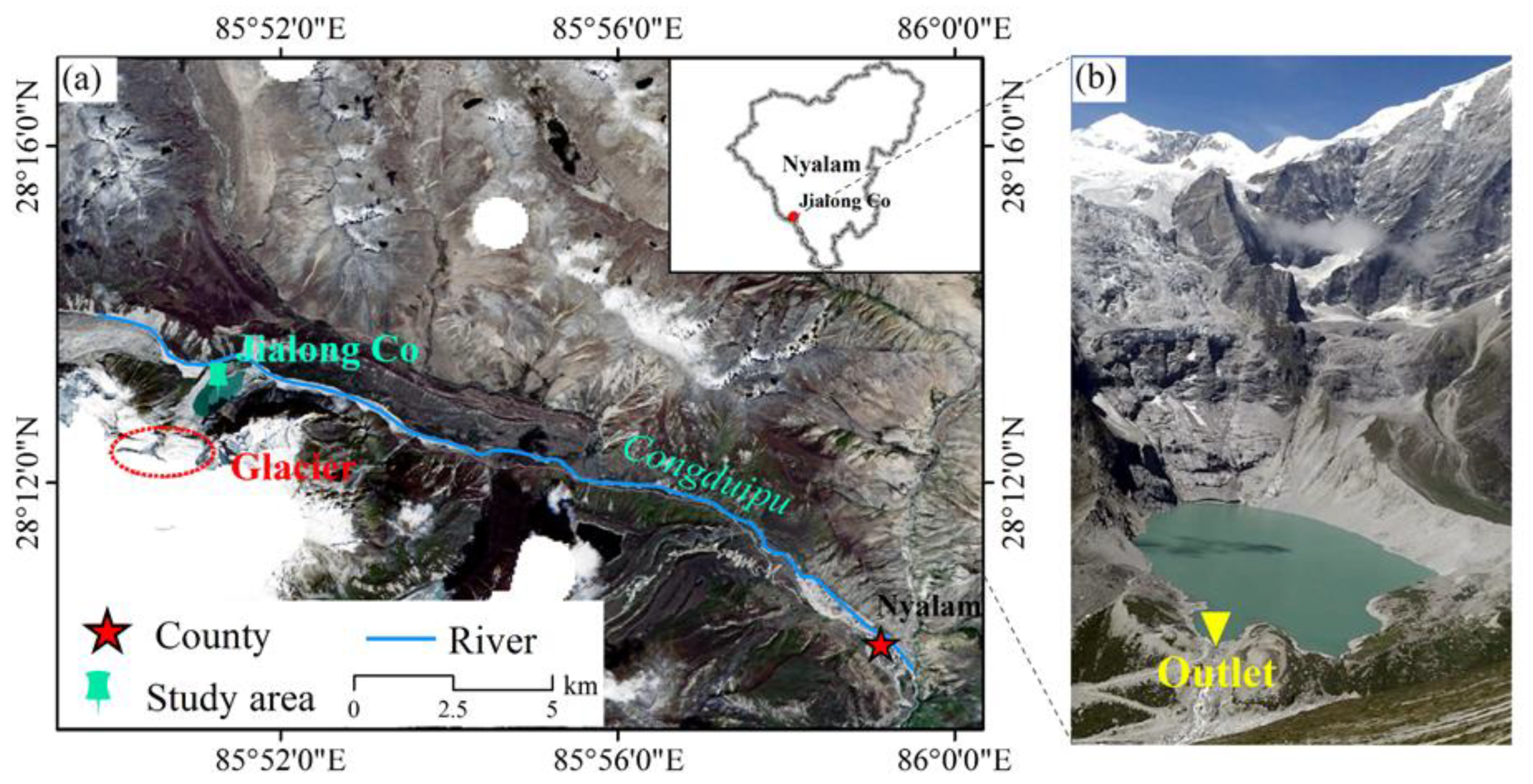
The Jialong Co glacial lake (28.2°N, 85.85°E) is located in the central Himalayas, between the Xixiabangma and Mount Everest mountain ranges, 20.6 km from Nyalam County, with a watershed area of 2018.4 km2 and a main-stream length of 86.5 km (Figure 1). According to a 2020 field survey, the Jialong Co mother glacier has retreated significantly in recent years, and the glacial lake is no longer directly connected. The glacial lake is a moraine lake with an area of approximately 0.60 ± 0.02 km2, a lake surface elevation of 4331 m, a depth range from 2 to 135 m, a mother glacial area of 4.53 km2, and a reservoir capacity of (3.75 ± 0.38) × 107 m3. The region has a highland semi-humid monsoon climate zone, with cold winters and low temperatures. The average annual temperature is 3.67 °C, rainfall is relatively abundant, with the most precipitation occurring in June and July, with an average annual rainfall of 657.3 mm [13,25].
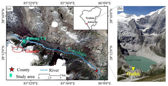
Figure 1.
Geographic location of the Jialong Co glacial lake (a) (background image: Sentinel-2 MSI image, September 2020). Photos of the glacial lake at Jialong Co (b).
2.2. Data and Methods
2.2.1. Remote Sensing Data
In this study, Landsat series images and Sentinel-2 optical images acquired from 2000 to 2021 were employed to extract the boundary of glacial lake using the method of manual interpretation. These optical images were collected from the United States Geological Survey (https://earth explorer.usgs.gov/ (accessed on 20 May 2022)) and their details are presented in Table 1, which are characterized by higher temporal and spatial resolution, and have been extensively used for mapping glacier movements and glacial lake boundaries [26,27].

Table 1.
Remote sensing data.
2.2.2. Meteorological Datasets
This study utilized rainfall and temperature data from the Global Land Surface Monthly Mean Climate Dataset (http://www.cru.uea.ac.uk/data (accessed on 5 July 2022)) published by the University of East Anglia’s Climatic Research Unit (CRU) in the United Kingdom, with a spatial resolution of 0.5° × 0.5°, for the 1990–2020 period.
2.2.3. UAV Data and Processing
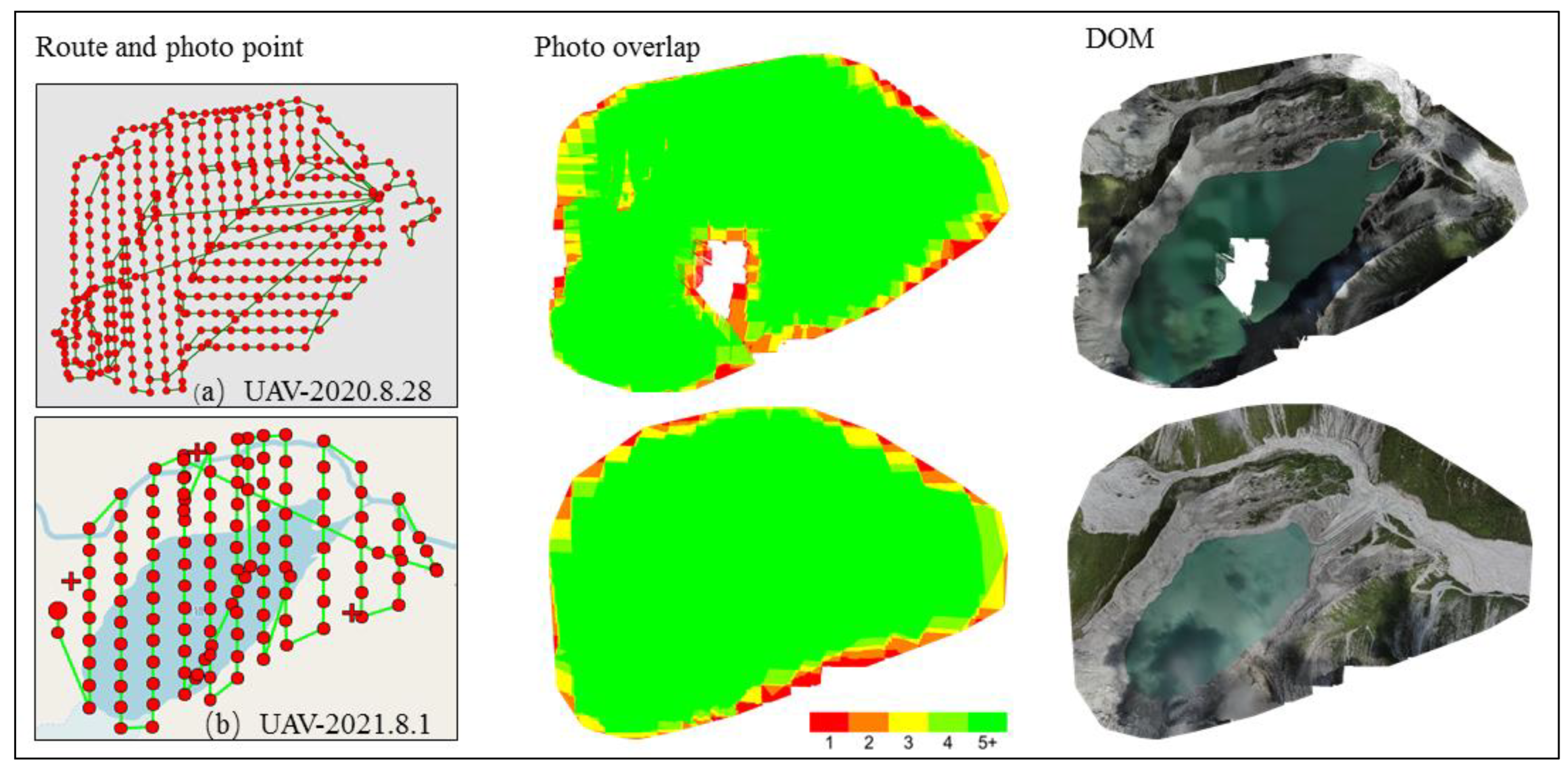
In this study, two field surveys were conducted on 28 August 2020 and 1 August 2021 during the glacial melt season using a DJI Royal PRO UAV on the Jialong Co glacial lake. Detailed aerial survey information is provided in Table 2. The DJI PRO is a quadruped that serves as a convenient, low-cost, powerful, high-resolution photogrammetry UAV. It has a maximum flight altitude of 6000 m, a flight time of approximately 30 min, and a built-in GPS/IMU positioning module for determining the position and altitude of exposure points. Due to the difficult terrain surrounding the glacial lake, this study used Pix4D capture for route planning (Figure 2) to automatically take pictures at specific intervals along a set flight path and record the position and altitude of the UAV at the exposure point in a JPEG image.

Table 2.
UAV aerial survey details.
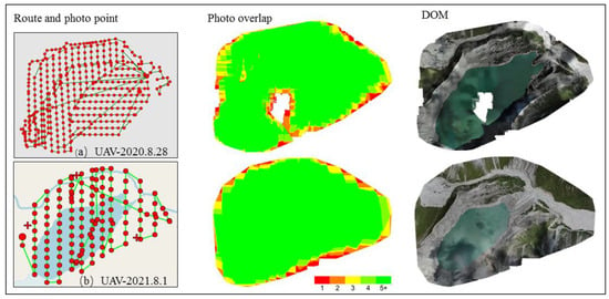
Figure 2.
The two UAV aerial survey routes, photo points, photo overlap, and orthophoto display.
The UAV data were processed with Pix4Dmapper software (Figure 3) using the three following steps:

Figure 3.
UAV aerial survey data acquisition and internal data processing.
- (1)
- Initial processing: First, the feature matching SIFT algorithm was used to search for and match image points of the same name with a specific overlap area, and second, the geometric position and orientation of each exposure point were reconstructed using internal parameters (focal length and image principal point coordinates) and external parameters (i.e., POS data) with the WGS84 coordinate system to create a sparse point cloud.
- (2)
- Point cloud encryption: Point cloud encryption can be achieved through the operations of pixel scale settings and point cloud filters. The spatial resolution of point cloud is improved after such the operations, thus contributing to create an irregular network in the next step.
- (3)
- Raster digital surface model (DSM) and orthophoto generation: DSM and DOM were the final products of UAV surveying. The DSM was reconstructed by means of a dense point cloud or irregular network, and for complex terrain areas, a higher accuracy could be achieved by means of a dense point cloud method.
2.2.4. Calculation of Earthwork Volume
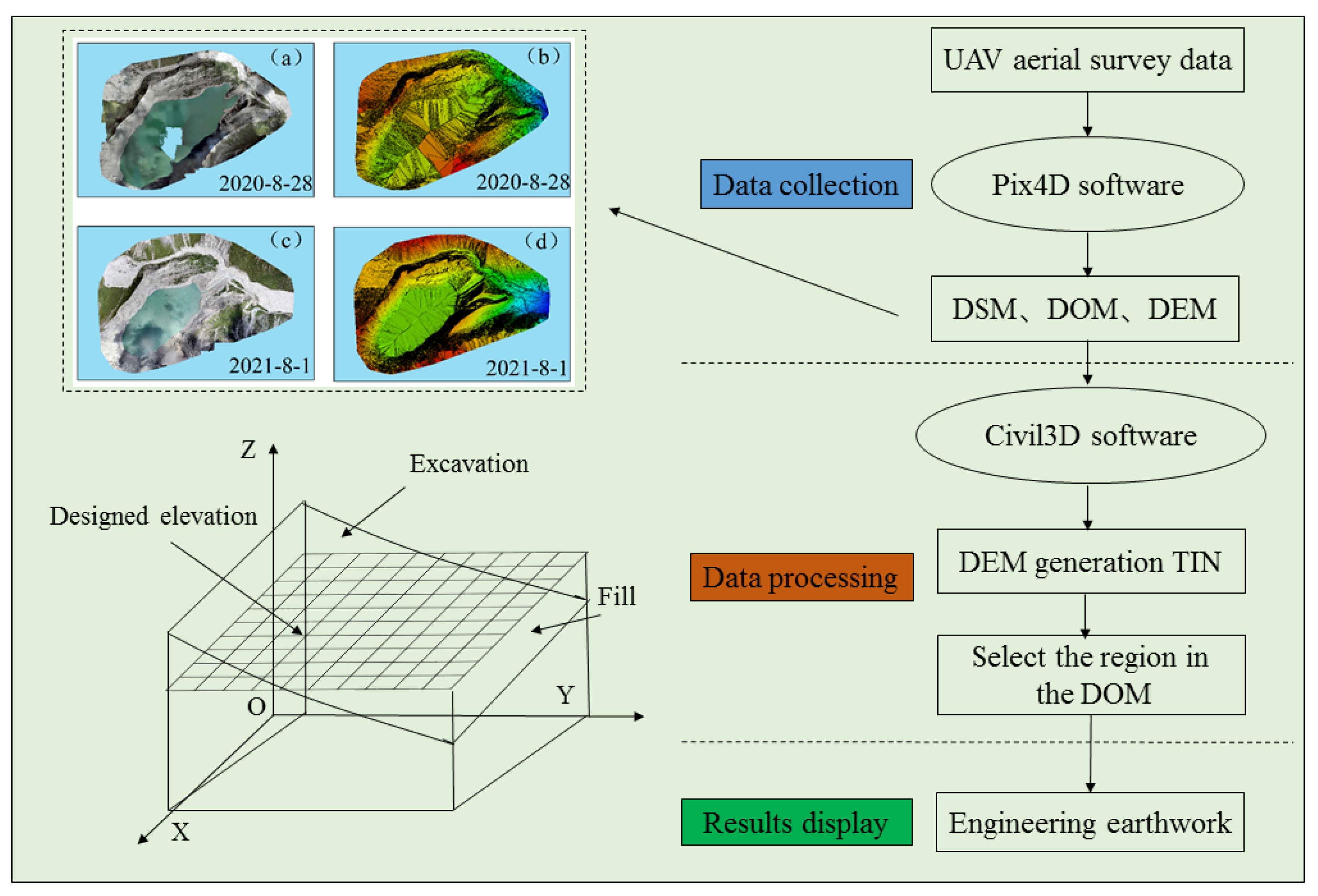
In this paper, aerial survey data were collected from the terrain before and after the comprehensive engineering management of the glacial lake using the UAV, and the internal data were processed using the Pix4D software. The volume of each excavation and backfill area could be calculated by calculating the volume size of the area that was enclosed by each dividing line. Then each excavation and backfill area can be summed up as the amount of excavation and filling of soil and rock in the requested area [28,29]. Figure 4 depicts the flow of calculating the volume of earth and rock for the two phases of terrain before and after integrated project management.
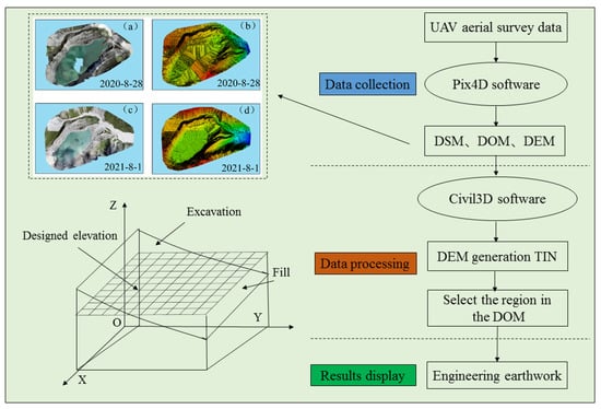
Figure 4.
Flow chart for earth and rock volume calculation. (a) DOM-28 August 2020. (b) DSM-28 August 2020. (c) DOM-1 August 2020. (d) DSM-1 August 2020.
2.2.5. Glacial Lake Depth Measurement
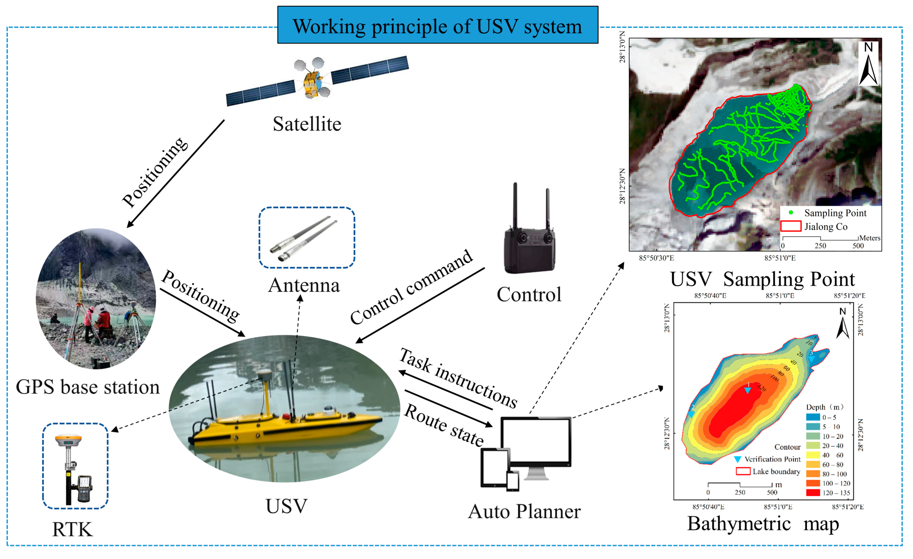
The water depth data of the glacial lake were obtained in this study through field sampling with a single-beam sonar USV bathymetry system (Figure 5). The benefits of a single-beam sonar bathymetry system include portability, power, and high measurement accuracy. A navigation system was outfitted for monitoring the hull attitude and real-time positioning of the USV, maintaining the lines, and measuring the depth with a horizontal positioning error of ±8 mm+1 ppm, and the depth data acquired by the single-beam sonar were ±1 cm+0.1% H. The lake depth was estimated with uncertainty using the sonar acquisition software HydroSurvey, bathymetry data were measured, and the position of the USV was displayed on the computer screen in real time.
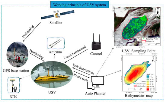
Figure 5.
Working principle of the USV bathymetry system.
2.2.6. Volume Calculation
Volume is critical in assessing glacial lake hazards and simulating GLOFs. Kriging interpolation, also known as spatial local interpolation, is a method of unbiased optimal estimation of regionalized variables in a finite area based on semi-variance function theory and structural analysis and is one of the main elements of geostatistics. The targeted area depth of the glacial lake was obtained from the on-site surveys conducted by an unmanned vessel bathy-metric system on 28 August 2020 and 1 August 2021, and then the depth of each pixel of the glacial lake was estimated using the kriging interpolation method in ArcGIS software according to the depth of the targeted area. The volume of the glacial lake is further estimated by multiplying the depth of each pixel by its area (Equation (1)). The uncertainty weight for this volume assessment process was set to ±10%, as judged by the data from field rope measurements.
where V is the reservoir volume of the glacial lake (m3), is the depth at pixel i (m), and P is the pixel size of the bathymetric map (m2).
2.2.7. Uncertainty Calculation
The main issue was interpreting and attributing various elements in various feature areas. Many Chinese researchers have already examined this topic, but the results are frequently unsatisfactory due to the influence of subjective factors. The glacial lake area was calculated using the Universal Transverse Mercator Projection coordinate system (UTM), and its uncertainty δ was estimated using the following formula [30] (Equation (2)):
where δ refers to the uncertainty in the area of an individual glacial lake, P is the perimeter, and G is the spatial resolution using remotely sensed data.
3. Results
3.1. Accuracy Analysis
This paper examines the accuracy of the Jialong Co glacial lake in the area covered by UAV imagery using high-resolution Sentinel-2 MSI imagery from 2020 and 2021. The images in this study area were clear and small and did not require further alignment; the accuracy uncertainty was determined by the image resolution and the effect of mountain shadows. As a result, the magnitude of the error in this paper was determined by comparing the UAV and Sentinel-2 MSI glacial lake contours (Figure 6).

Figure 6.
Comparison of Sentinel-2 MSI and UAV data accuracy. (a) Sentinel-2 16 July 2020. (b) UAV 28 August 2020. (c) Sentinel-2 4 September 2021. (d) UAV 1 August 2020.
When comparing the accuracy of the UAV image data and that of the higher spatial resolution Sentinel-2 MSI visual interpretation of the Jialong Co glacial lake area, as shown in Table 3, the two results were in good agreement, and the overall accuracy reached over 98.48%.

Table 3.
Comparison of the outlines from UAV and Sentinel2 MSI.
3.2. Changes in Area, and Circumference of the Glacial Lake
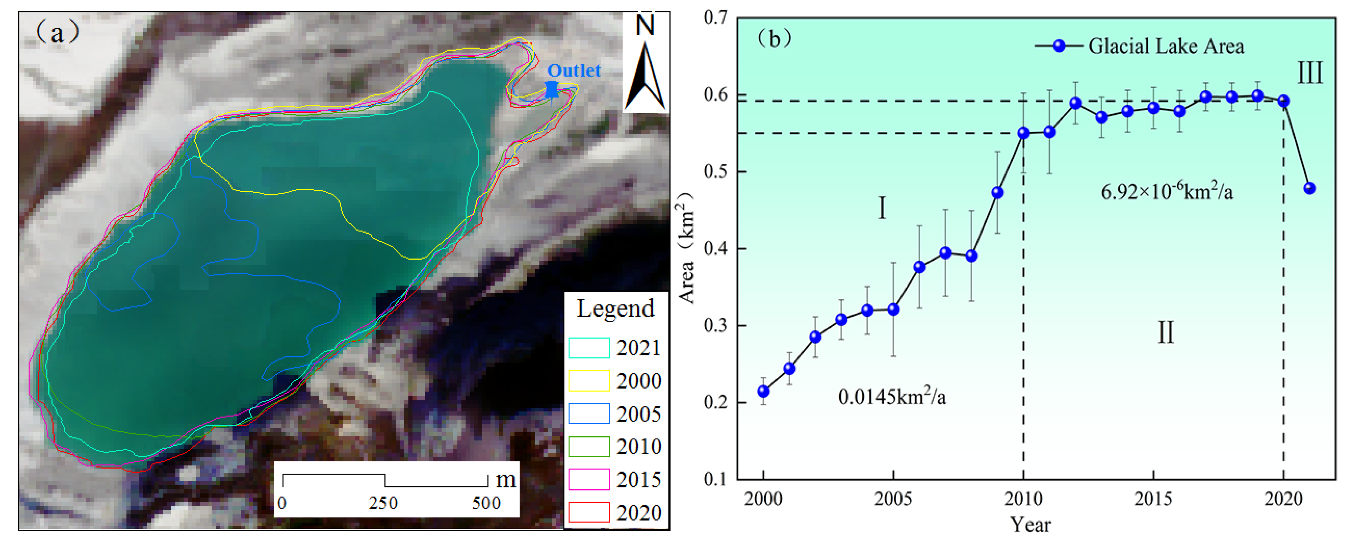
The contours of the glacial lake could be extracted from the high-resolution remote sensing images and unmanned aerial survey images from 2000 to 2021 using ArcGIS, which could clearly map the contours of the glacial lake and the nonglacial lake areas where the existing mountain shadows could be combined with the DSM to help determine the boundaries. Figure 7 depicts the annual area change of the glacial lake from 2000 to 2021, with a clear trend of expansion. The evolutionary process was divided into three stages. The glacial lake area increased from 0.2148 ± 0.0176 km2 to 0.5503 ± 0.0519 km2 during the first stage, which lasted from 2000 to 2010. The second stage, 2010–2020, exhibited consistent annual growth. The glacial lake area increased from 0.5503 ± 0.0519 km2 to 0.5921 ± 0.0003 km2, and the glacial lake was subjected to a comprehensive engineering treatment process in the third stage, from 2020 to 2021. The lake’s length and area were reduced by 0.6014 km and 0.1136 km2, respectively.
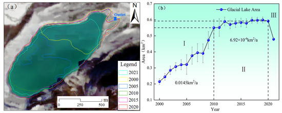
Figure 7.
The change process of the area of Jialong Co glacial lake from 2000 to 2021. (a) The expansion of Jialong Co glacial lake from 2000 to 2021. (b) Interannual variation in the area of Jialong Co glacial lake from 2000 to 2021.
3.3. Glacial Lake Water Level, Volume Change and Earthwork Volume Calculation
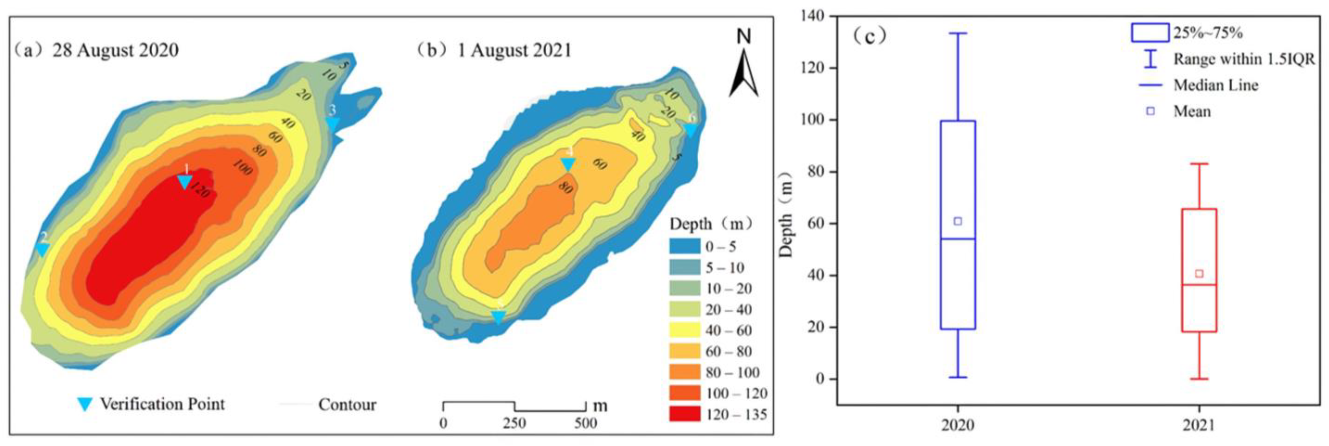
A depth map of the Jialong Co glacial lake was created using ArcGIS software to interpolate the bathymetric data spatially. The slope steepened as the density of the isobaths increased, suggesting that the glacial lake gradually deepened from the outside to the center. The slope was steeper near the glacier in the south than in the north.
Field bathymetric data were collected using an unmanned boat bathymetric system on 28 August 2020 and 1 August 2021, prior to and after comprehensive engineering management of the Jialong Co glacial lake. According to the results of the unmanned boat bathymetry (Figure 8), the maximum depth measured in 2020 was 133.43 m, and the maximum depth measured in 2021 was 83.43 m, with a 50 m drop in water level.
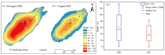
Figure 8.
Depth survey map of Jialong Co glacial lake. (a) Depth survey map on 28 August 2020. (b) Depth survey map on 1 August 2021. (c) Depth distribution box plot.
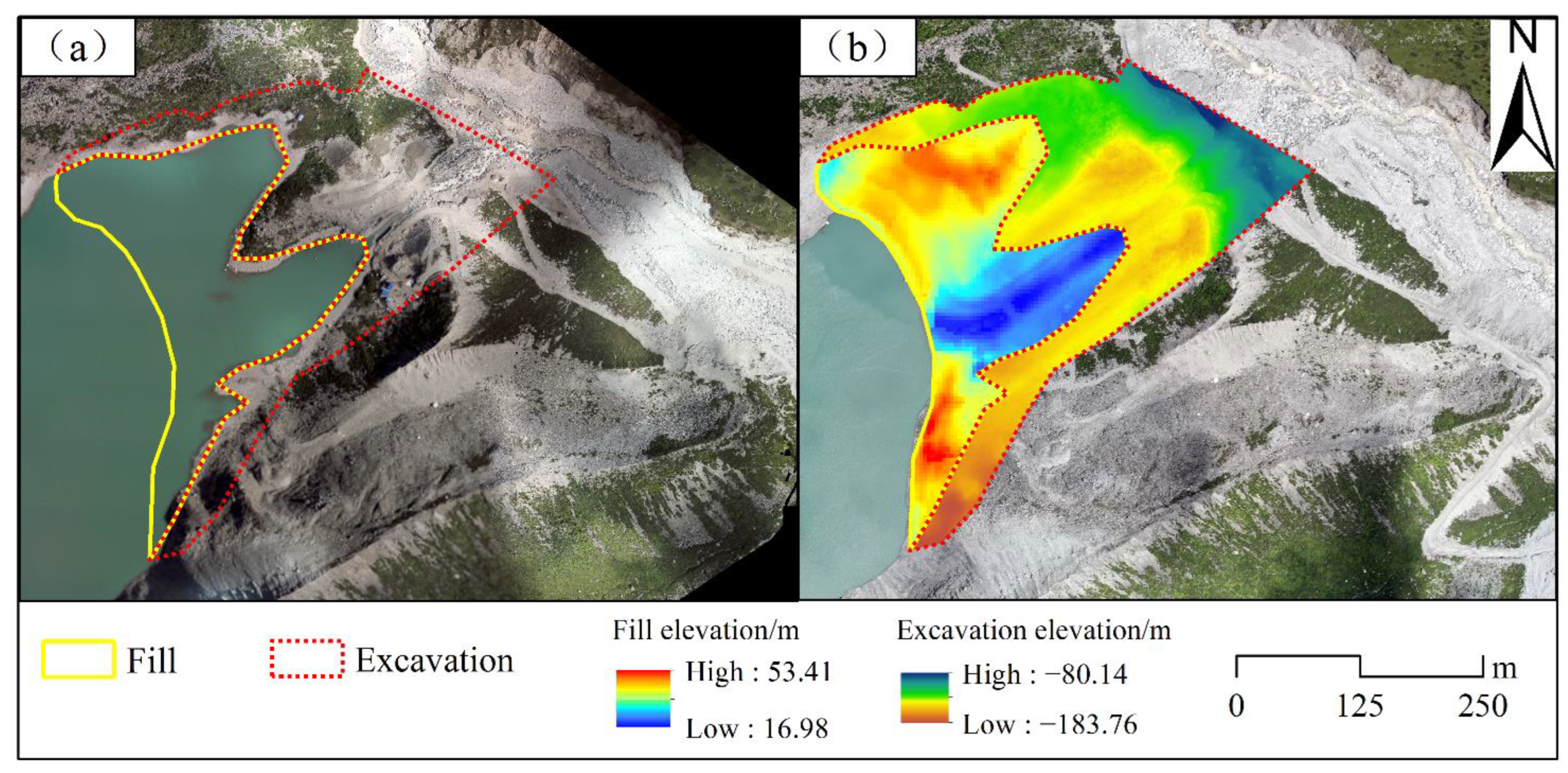
On 28 August 2020, the volume of Jialong Co glacial lake was (3.72 ± 0.37) × 107 m3. On 1 August 2021, the volume of the glacial lake was (1.82 ± 0.18) × 107 m3, and comprehensive engineering management was 1.90 × 10⁷ m3. Figure 9 shows the project management before and after excavation of 8.13 million square meters and the filling of 1.24 million square meters.
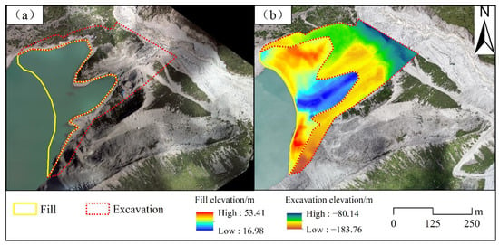
Figure 9.
Earthwork calculation before and after the Jialong Co glacial lake comprehensive engineering management. (a) Range of fill and excavation. (b) Difference in elevation change within the fill and excavation area.
3.4. Geomorphological Analysis
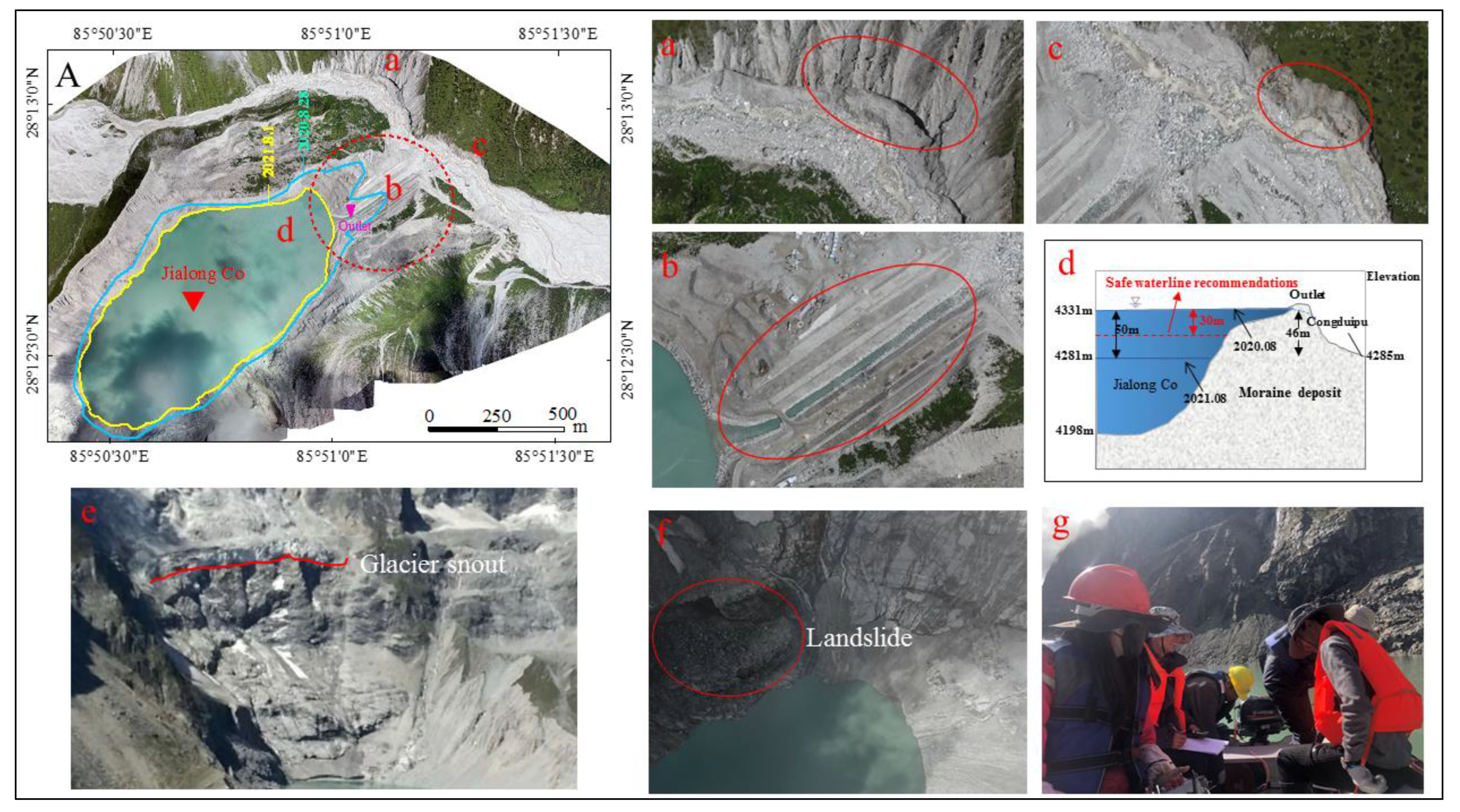
In this study, field surveys of Jialong Co glacial lake in August 2020 and August 2021 revealed that its outlet was located on its eastern side (Figure 10). Glacial melt and glacial lake outburst floods in the upper reaches of the Chongduipu river severely eroded the riverbank opposite the outlet, resulting in the collapse of moraines around the river channel (Figure 10a,c). Engineering reinforcement of the outlet channel and surrounding dam effectively reduced the severe scouring of the foot of the final moraine at the spillway outlet, as well as the likelihood of glacial lake outbursts caused by ice avalanches and landslides (Figure 10b). The elevation difference between the lake surface and the downstream Chongduipu river was 46 m, from 2020–2021 concerning the Jialong Co glacial lake comprehensive engineering management after the water level dropped 50 m, effectively reducing the glacier and mountain collapse-induced glacial lake surge and moraine lake dam burst risk (Figure 10d). The summer 2021 field survey revealed that, as the temperature increased, the mother glacier retreated over time and receded to the bedrock slope, completely separating from the lake (Figure 10e). Its ice tongue was almost perpendicular to the lake, with visible cracks in the steep tongue. Because of the steep front of the ice tongue and the presence of crevasses, ice avalanches/disintegrations were likely, and ice has fallen into the glacial lake. Field investigations of the Garonne fault revealed the presence of a landslide near the glacial lake’s terminus (Figure 10f).
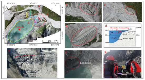
Figure 10.
Unmanned aerial survey images of Jialong Co glacial lake, including a general overview (A), upstream meltwater erosion banks (a), engineering management area (b), outlet erosion banks (c), profile around the outlet (d), the snout of the mother glacier (e), landslide connected to the lake (f), and manual bathymetric operations (g).
Although the landslide did not completely enter the lake and had no obvious negative consequences, the landslide could have triggered a disaster, and the collapse of the mountain could have caused large waves and reduced the stability of the lake dam. After the water level drop treatment, even if a landslide occurs, the generated surge height will be greatly reduced, less dangerous, and will have less pressure on the lake dam. In summary, the risk assessment and lake environmental change studies have shown that the use of slotting and flood channel modification to lower the glacial lake level reduces the lateral water pressure on the moraine ridge and blocks the effect of erosion on the foot of the moraine slope at the outlet of the flood channel, which can help to mitigate the occurrence of glacial lake outbursts and is essential for exploring glacial lake management experiences.
4. Discussion
4.1. Response of Glacial Lakes to Climate Change
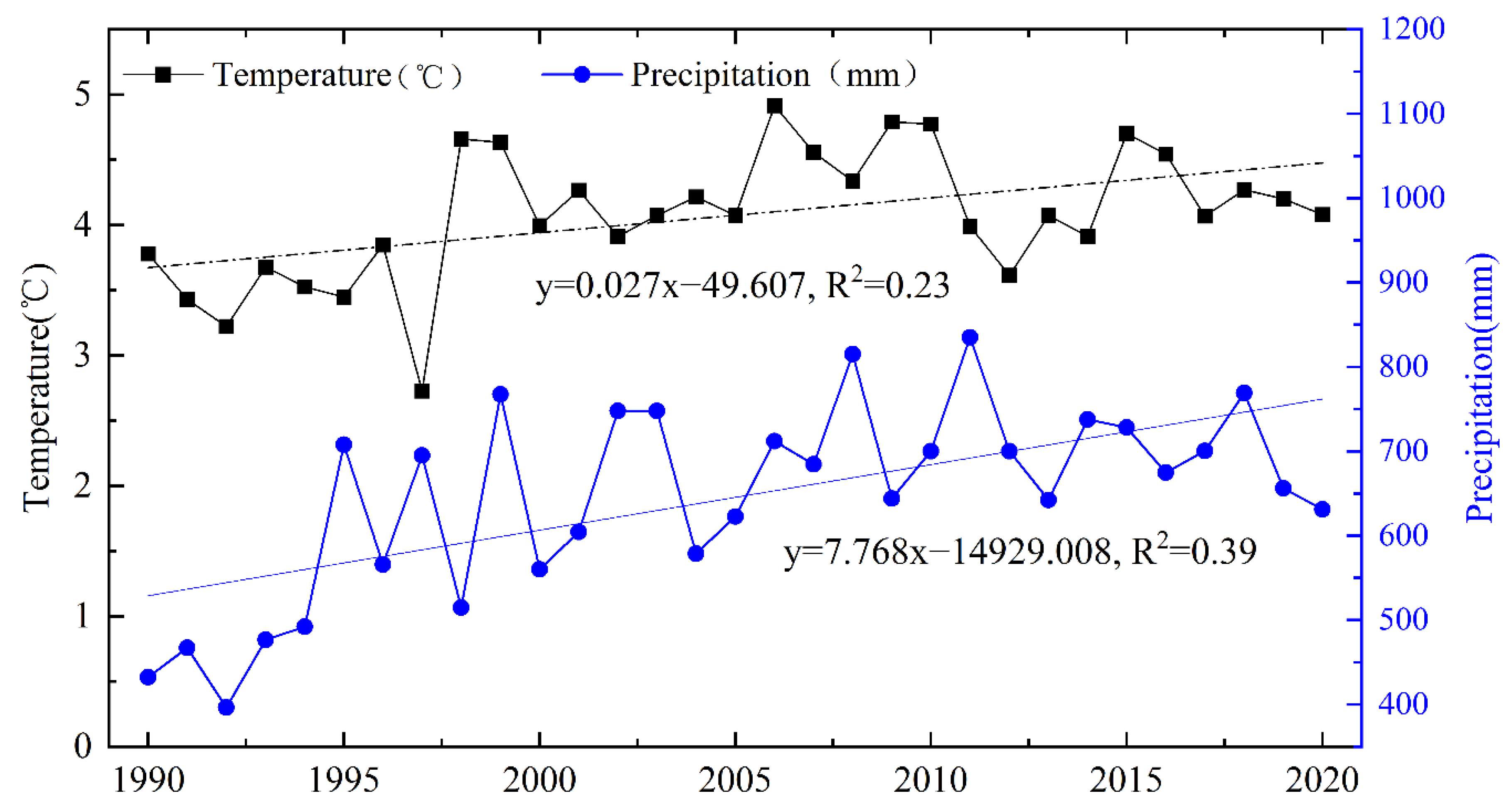
Climate change has significantly impacted alpine glacial areas in recent decades [31]. Glacial lakes are bodies of water formed by glacial activity or glacial retreat processes; changes in glacial lakes are determined by their water balance and are closely related to climate change [32]. Between 1990 and 2020, the average annual temperature in Nyalam County increased, as did the annual precipitation, with an average annual temperature change rate of 0.027 °C·a−1. The annual precipitation change rate was 7.768 mm·a−1 (Figure 11). Climate change has had an impact on glacial lake changes, either directly or indirectly. Warmer temperatures hasten glacial melting, increasing the recharge of glacial meltwater to the glacial lake; on the other hand, more precipitation hastens the recharge of rainwater to the glacial lake via slope runoff. The continued expansion of the glacial lake is positively correlated with the region’s continued temperature increase, and increased annual precipitation is also a source of recharge for the glacial lake’s expansion.
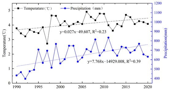
Figure 11.
The changes in annual air temperature and precipitation in Nyalam County during 1990–2020.
4.2. Uncertainty Assessment of Depth Data
Manual vertical rope measurements were used to establish validation points to validate the glacial lake depth data, and the locations of the validation points are shown in Figure 8. Table 4 shows the results of the comparison between sonar data and manually collected data, which shows that the accuracy of the USV bathymetry was low in shallower waters. The larger errors at Points 2 and 6 were most likely due to a combination of measurement errors in the USV system and human factors. Generally, considering all types of uncertainties, this study concluded that an uncertainty of <10% could accurately assess the lake depth and volume of the glacial lake. There is a lack of sufficient experiments in alpine environments; thus, further studies are needed to show how to avoid external environmental disturbances such as wind, water-wave background noise and so on in field investigations to improve the bathymetric accuracy of glacial lakes.

Table 4.
Depth data at validation points.
5. Conclusions
To conduct a comprehensive survey and comparative study, this study employed a combination of remote sensing, geographic information system (GIS), and field survey methods to assess the lake surface conditions, stability of the lake dam, and the surrounding terrain before and after the Jialong Co glacial lake comprehensive engineering management. The following results were found:
- (1)
- The Jialong Co glacial lake area increased from 0.2148 ± 0.0176 km2 to 0.5921 ± 0.0003 km2 between 2000 and 2020 (before engineering treatment). The rate of glacial lake expansion in 2000-2010 (0.0145 km2/a) was greater than the rate in 2011–2020 (6.92 × 10⁻⁶ km2/a). From 2020 to 2021 (after engineering treatment), the glacial lake perimeter, area, and volume were reduced by 0.6014 km, 0.1136 km2, and 1.90 × 10⁷ m3, respectively. The excavation area was 8.13 million square meters before and after the engineering treatment, and the fill area was 1.24 million square meters. Bathymetry data from an unmanned boat showed that the water level on the glacial lake’s surface has dropped by 50 m.
- (2)
- According to the findings of the UAV topographic survey, the engineering reinforcement of the outlet channel and surrounding dam effectively mitigated the severe scouring of the foot of the final moraine at the spillway’s outlet and reduced the likelihood of glacial lake outbursts caused by ice avalanches and landslides.
- (3)
- The comprehensive engineering treatment process of this typical glacial lake effectively lowered the lake’s water level, improved the stability of the moraine and lake dam, and can serve as a scientific foundation for other glacial lake outburst risk assessments and disaster mitigation and management measures. Thus, assessing the comprehensive engineering management effects of the key glacial lakes is critical for expanding glacial lake management knowledge.
Author Contributions
Conceptualization, X.C. and D.S.; methodology, X.C. and Q.L.; software, X.C., D.L. and X.W.; data acquisition, D.S., D.L., X.C., B.H. and M.W.; data processing, X.C., L.C., Y.L. and W.C.; writing—original draft, X.C.; writing—review and editing, D.S., Z.Z., W.L. and X.Z. All authors have read and agreed to the published version of the manuscript.
Funding
This research was funded by the Second Tibetan Plateau Scientific Expedition and Research Program (STEP) (Grant No. 2019QZKK0205), the Strategic Priority Research Program of the Chinese Academy of Sciences (Grant No. XDA19070501), the National Natural Science Foundation of China (Grant No. 42171148, 42127802 and 2022QB-052) and the Natural Science Foundation of Gansu (Grant No. 20JR5RA444, 22JR5RA247 and 20JR10RA180).
Data Availability Statement
The data used to support the findings of this study are available from the corresponding author upon request.
Acknowledgments
We thank the USGS for providing the Landsat data and Sentinel-2 MSI (http://glovis.usgs.gov/ (accessed on 25 May 2022) images. We also thank the reviewers for their constructive comments, which helped to further improve the quality of this study.
Conflicts of Interest
The authors declare no conflict of interest.
References
- Qin, D.; Yao, T.; Ding, Y.; Ren, J. Scientific dictionary of the cryosphere. Meteorol. Mon. 2016. [Google Scholar]
- Li, D.; Shangguan, D.; Huang, W. Research on the area change of Lake Merzbacher in the Tianshan Mountains during 1998–2017. J. Glaciol. Geocryol. 2020, 42, 1126–1134. [Google Scholar]
- Cook, K.L.; Andermann, C.; Gimbert, F.; Adhikari, B.R.; Hovius, N. Glacial lake outburst floods as drivers of fluvial erosion in the Himalaya. Science 2018, 362, 53–57. [Google Scholar] [CrossRef] [PubMed]
- Allen, S.K.; Zhang, G.; Wang, W.; Yao, T.; Bolch, T. Potentially dangerous glacial lakes across the Tibetan Plateau revealed using a large-scale automated assessment approach. Sci. Bull. 2019, 64, 435–445. [Google Scholar] [CrossRef]
- Liu, J.; Zhang, J.; Gao, B.; Li, Y.; Mengyu, L.; Wujin, D.; Zhou, L. An overview of glacial lake outburst flood in Tibet. China J. Glaciol. Geocryol. 2019, 41, 1335–1347. [Google Scholar]
- Bolch, T.; Kulkarni, A.; Kääb, A.; Huggel, C.; Paul, F.; Cogley, J.G.; Frey, H.; Kargel, J.S.; Fujita, K.; Scheel, M.; et al. The state and fate of Himalayan glaciers. Science 2012, 336, 310–314. [Google Scholar] [CrossRef]
- Sakai, A. Glacial lakes in the Himalayas: A review on formation and expansion processes. Glob. Environ. Res. 2012, 16, 23–30. [Google Scholar]
- Ma, J.; Song, C.; Wang, Y. Spatially and Temporally Resolved Monitoring of Glacial Lake Changes in Alps during the Recent Two Decades. Front. Earth Sci. 2021, 9, 1–11. [Google Scholar] [CrossRef]
- Shugar, D.H.; Burr, A.; Haritashya, U.K.; Kargel, J.S.; Watson, C.S.; Kennedy, M.C.; Bevington, A.R.; Betts, R.A.; Harrison, S.; Strattman, K. Rapid worldwide growth of glacial lakes since 1990. Nat. Clim. Chang. 2020, 10, 939–945. [Google Scholar] [CrossRef]
- Westoby, M.; Glasser, N.; Brasington, J.; Hambrey, M.; Quincey, D.; Reynolds, J. Modelling outburst floods from moraine-dammed glacial lakes. Earth-Sci. Rev. 2014, 134, 137–159. [Google Scholar] [CrossRef]
- Brun, F.; Berthier, E.; Wagnon, P.; Kääb, A.; Treichler, D. A spatially resolved estimate of High Mountain Asia glacier mass balances from 2000 to 2016. Nature Geoscience. 2017, 10, 668–670. [Google Scholar] [CrossRef] [PubMed]
- Nie, Y.; Liu, Q.; Wang, J.; Zhang, Y.; Sheng, Y.; Liu, S. An inventory of historical glacial lake outburst floods in the Himalayas based on remote sensing observations and geomorphological analysis. Geomorphology 2018, 308, 91–106. [Google Scholar] [CrossRef]
- Zheng, G.; Allen, S.K.; Bao, A.; Ballesteros-Cánovas, J.A.; Huss, M.; Zhang, G.; Li, J.; Yuan, Y.; Jiang, L.; Yu, T.; et al. Increasing risk of glacial lake outburst floods from future Third Pole deglaciation. Nat. Clim. Chang. 2021, 11, 411–417. [Google Scholar] [CrossRef]
- Li, D.; Shangguan, D.; Wang, X.; Ding, Y.; Su, P.; Liu, R.; Wang, M. Expansion and hazard risk assessment of glacial lake Jialong Co in the central Himalayas by using an unmanned surface vessel and remote sensing. Sci. Total Environ. 2021, 4, 147249. [Google Scholar] [CrossRef]
- Ramsankaran, R.; Navinkumar, P.J.; Dashora, A.; Kulkarni, A.V. UAV-Based Survey of Glaciers in Himalayas: Challen-ges and Recommendations. J. Indian Soc. Remote Sens. 2021, 49, 1171–1187. [Google Scholar] [CrossRef]
- Sazeda Begam, Dhrubajyoti Sen, Subhasish Dey, Moraine dam breach and glacial lake outburst flood generation by physical and numerical models. J. Hydrol. 2018, 563, 694–710. [CrossRef]
- Ahmed, R.; Wani, G.F.; Ahmad, S.T.; Sahana, M.; Singh, H.; Ahmed, P. A Review of Glacial Lake Expansion and Associated Glacial Lake Outburst Floods in the Himalayan Region. Earth Syst. Environ. 2021, 5, 695–708. [Google Scholar] [CrossRef]
- Chen, X.; Cui, P.; Li, Y.; Yang, Z.; Qi, Y. Changes in glacial lakes and glaciers of post-1986 in the Poiqu River basin, Nyalam, Xizang (Tibet). Geomorphology 2007, 88, 298–311. [Google Scholar] [CrossRef]
- Liu, J.J.; Cheng, Z.L.; Su, P.C. The relationship between air temperature fluctuation and Glacial Lake Outburst Floods in Tibet, China. Quat. Int. 2014, 321, 78–87. [Google Scholar] [CrossRef]
- Zhang, T.; Wang, W.; Gao, T.; An, B.; Yao, T. An integrative method for identifying potentially dangerous glacial lakes in the Himalayas. Sci. Total Environ. 2022, 806, 150442. [Google Scholar] [CrossRef]
- Chen, X.; Cui, P.; Yang, Z.; Qi, Y. Debris Flows of Chongduipu Gully in Nyalam County, 2002: Cause and control. J. Glaciol. Geocryol. 2006, 5, 776–781. [Google Scholar]
- Wang, W.; Gao, Y.; Anacona, P.I.; Lei, Y.; Xiang, Y.; Zhang, G.; Li, S.; Lu, A. Integrated hazard assessment of Cirenmaco glacial lake in Zhangzangbo valley. Cent. Himalayas Geomorphol. 2018, 306, 292–305. [Google Scholar] [CrossRef]
- Wu, K.P.; Liu, S.Y.; Zhu, Y.; Xie, F.M.; Gao, Y.P. High-resolution monitoring of glacier dynamics bred on unmanned aerial vehicle survey in the MeiIi Snow Mountain. Prog. Geogr. 2021, 40, 1581–1589. [Google Scholar] [CrossRef]
- Asta, E.D.; Forlani, G.; Roncella, R.; Santise, M.; Diotri, F.; di Cella, U.M. Unmanned Aerial Systems and DSM matching for rock glacier monitoring. ISPRS J. Photo-Grammetry Remote Sens. 2017, 127, 102–114. [Google Scholar]
- Duan, H.; Yao, X.; Zhang, D.; Qi, M.; Liu, J. Glacial Lake Changes and Identification of Potentially Dangerous Glacial Lakes in the Yi’ong Zangbo River Basin. Water 2020, 12, 538. [Google Scholar] [CrossRef]
- Khadka, N.; Zhang, G.; Thakuri, S. Glacial lakes in the Nepal Himalaya: Inventory and decadal dynamics (1977–2017). Remote Sens. 2018, 10, 1913. [Google Scholar] [CrossRef]
- Wang, X.; Guo, X.; Yang, C.; Liu, Q.; Wei, J.; Zhang, Y.; Liu, S.; Zhang, Y.; Jiang, Z.; Tang, Z. Glacial lake inventory of High Mountain Asia (1990–2018) derived from Landsat images. Earth Syst. Sci. 2020, 12, 2169–2182. [Google Scholar] [CrossRef]
- Gu, N.; Feng, Z.; Luo, X. Digital elevation model based on aerial UAV image. J. Being For. Univ. 2007, 29, 152–155. [Google Scholar]
- Liu, W. Application of Unmanned Aerial Vehicle Photogrammetry in Volume of Earth Calculation. Mod. Surv. Mapp. 2018, 41, 6–8. [Google Scholar]
- Hanshaw, M.N.; Bookhagen, B. Glacial areas, lake areas, and snow lines from 1975 to 2012: Status of the Cordillera Vilcanota, including the Quelccaya Ice Cap, northern central Andes, Peru. Cryosphere 2014, 8, 359–376. [Google Scholar] [CrossRef]
- Kochel, R.C.; Trop, J.M. Active processes, morphology, and dynamics of icy debris fans: Landform evolution along rapidly degrading escarpments in alpine regions undergoing recent deglaciation. Geomorphology 2012, 151–152, 59–76. [Google Scholar] [CrossRef]
- Luo, W.; Zhang, G.; Chen, W.; Xu, F. Response of glacial lakes to glacier and climate changes in the western Nyainqentanglha range. Sci. Total Environ. 2020, 735, 139607. [Google Scholar] [CrossRef] [PubMed]
Disclaimer/Publisher’s Note: The statements, opinions and data contained in all publications are solely those of the individual author(s) and contributor(s) and not of MDPI and/or the editor(s). MDPI and/or the editor(s) disclaim responsibility for any injury to people or property resulting from any ideas, methods, instructions or products referred to in the content. |
© 2022 by the authors. Licensee MDPI, Basel, Switzerland. This article is an open access article distributed under the terms and conditions of the Creative Commons Attribution (CC BY) license (https://creativecommons.org/licenses/by/4.0/).

