Article

Changes in the Structure of the Snow Cover of Hansbreen (S Spitsbergen) Derived from Repeated High-Frequency Radio-Echo Sounding

1
Institute of Earth Sciences, University of Silesia in Katowice, Bedzinska 60, 41-200 Sosnowiec, Poland
2
Institute of Geophysics Polish Academy of Sciences, Ksiecia Janusza 64, 01-452 Warszawa, Poland
*
Author to whom correspondence should be addressed.
Remote Sens. 2023, 15(1), 189; https://doi.org/10.3390/rs15010189
Submission received: 20 October 2022 / Revised: 22 December 2022 / Accepted: 25 December 2022 / Published: 29 December 2022

Abstract

:
This paper explores the potential of ground-penetrating radar (GPR) monitoring for an advanced understanding of snow cover processes and structure. For this purpose, the study uses the Hansbreen (SW Spitsbergen) records that are among the longest and the most comprehensive snow-cover GPR monitoring records available on Svalbard. While snow depth (HS) is frequently the only feature derived from high-frequency radio-echo sounding (RES), this study also offers an analysis of the physical characteristics (grain shape, size, hardness, and density) of the snow cover structure. We demonstrate that, based on GPR data (800 MHz) and a single snow pit, it is possible to extrapolate the detailed features of snow cover to the accumulation area. Field studies (snow pits and RES) were conducted at the end of selected accumulation seasons in the period 2008–2019, under dry snow conditions and HS close to the maximum. The paper shows that although the snow cover structure varies in space and from season to season, a single snow pit site can represent the entire center line of the accumulation zone. Numerous hard layers (HLs) (up to 30% of the snow column) were observed that reflect progressive climate change, but there is no trend in quantity, thickness, or percentage contribution in total snow depth in the study period. HLs with strong crystal bonds create a “framework” in the snowpack, which reduces compaction and, consequently, the ice formation layers slow down the rate of snowpack metamorphosis. The extrapolation of snow pit data through radar profiling is a novel solution that can improve spatial recognition of snow cover characteristics and the accuracy of calculation of snow water equivalent (SWE).

1. Introduction

Snow cover plays a vital role in the functioning of the glacial system. A thermal conductivity up to 20 times lower than ice [1] and albedo reaching 90% [2,3,4] make snow cover an efficient insulator, determining a glacier’s heat balance and the thermal properties of the underlying ice layers. Snow is the material composing a glacier, which makes it a key component of glacier mass balance [5,6] and the changes in its geometry. After deposition, snow cover undergoes a process of metamorphism, changing its physical properties in time and space [7,8]. This process depends on climatic conditions, the rate of accumulation, and the nature of ablation. The stratigraphic features of snow cover are the result of complex atmospheric, surface [9], and internal processes (water and water vapor migration, heat transfer, densification) [1,6,7,10] that determine the characteristics of the snowpack (grain size, density, presence of ice layers) and its evolution [11,12]. Due to the changing nature of the above conditions, the snowpack is made up of distinct layers of snow that differ by at least one physical feature. Furthermore, the snowpack is a freshwater reservoir [13] that through melting initiates supraglacial, englacial, and subglacial drainage [14,15], which influences basal sliding as well as transporting impurities [16,17,18] and mineral substances [19,20].
Pending climate change [21,22,23,24] in susceptible Arctic areas is manifested by general warming, more frequent winter thaws [25,26], a shorter duration of snow cover [13,27], and an earlier onset of snow-free days [28]. Rapid Arctic warming [22,29,30,31,32,33], much faster than the global average [22,31,33,34], affects the evolution of the snow cover [18] and requires studies of its response to these transformations [35]. There are more and more winter warm spells with temperatures above 0 degrees Celsius [36,37], and the amount of winter rainfall is increasing [26], which in the future may become even more frequent [25,38,39] and the dominant form of winter precipitation [40,41]. Sobota [42] indicated that little is known about the impact of rain-on-snow (ROS) phenomena on snow cover on glaciers. Both of the phenomena mentioned above can lead to the appearance of Ice Formations (IF) on the snow surface or below, which, due to their great hardness, density, and thermal conductivity, affect many glacial processes [43]. Liquid water during winter can also affect the thermal properties of the glacier by contributing to the formation of temperate ice layers [44].
Snow research on glaciers in Svalbard has been conducted since the 1930s [36,45,46] and has focused on snow accumulation. Later, snow accumulation and distribution were examined by numerous authors, e.g., Migała et al. [47]; Tveit and Killingtveit [48]; Grześ and Sobota [49]; Sand et al. [50]; Małecki [51]. More detailed studies, including hardness, density, distribution of SWE, and temperature within the snowpack were published by, e.g., Hodgkins et al. [14]; Moller et al. [52]; Sobota [53,54,55]; Sauter et al. [56]; Valt and Salvatori [9].
In the Hornsund fjord area, snow studies started on the Werenskioldbreen in the late 1950s [57,58] and were continued by Baranowski [59,60], Jania [61] and Grabiec [62]. Observations of the snow cover on Hansbreen have been conducted since 1989 by Pulina [63]; Glazovsky et al. [64] and Leszkiewicz and Pulina [65] who analyzed snow pit data and described phases of snowfall. Głowacki and Pulina [66] and Głowacki [67] investigated the snow cover’s chemical and physical properties at the end of winter. The snow cover chemistry was also examined by Nawrot et al. [68]; Barbaro et al. [16]; Kozioł et al. [17]; Spolaor et al. [18]. Uszczyk et al. [69] described the spatial distribution of winter accumulation and summer snow melting and the temporal pattern of meltwater released from the snow cover. Laska, Luks, Kępski. et al. [70] revised and unified snow pit data from 1989 to 2021.
Radio-echo sounding (RES) is a very effective and non-destructive method for carrying out snow studies. Snow depth (HS) is frequently the only feature derived from high-frequency RES. Radar snow surveys on glaciers in the southern part of Spitsbergen have been carried out by Grabiec et al. [71]; Melvold [72]; Laska et al. [73], Grabiec [35], and in other parts of Svalbard by e.g., Kohler et al. [74]; Winther et al. [75]; Bruland, Sand and Killingtveit [76]; Pinglot et al. [77]; Sand et al. [50], Taurisano et al. [78]; Dunse et al. [79], Van Pelt et al. [80], Singh et al. [81].
The study’s primary purpose was to determine the structure of snow cover on the glacier and its inter-seasonal variability based on repeated high-frequency RES. The difference in the dielectric properties of snow layers [82,83], mainly due to hardness and density, makes radar sounding a valuable technique for distinguishing individual layers and separating snow from firn [79,84]. In the paper, we demonstrate that based on ground-penetrating radar (GPR) data and a single snow pit on Hansbreen (South Spitsbergen), it is possible to extrapolate the detailed features of snow cover to the accumulation zone of the entire glacier. To the authors’ knowledge, this approach has not previously been undertaken. Layers determined from the GPR profiles are validated by assigning attributes from snow pit analysis. The method used in this study may improve the calculation of winter mass balance and contribute to hydrological models.

2. Study Area

Hansbreen is located in the northern part of the Hornsund fjord in Wedel Jarlsberg Land, southwest Spitsbergen (Figure 1). It is a medium-sized polythermal, tidewater glacier [85,86] that flows from north to south to terminate in Hansbukta bay [87] and can be considered representative of the entire region [26]. In 2015 Hansbreen covered an area of 51.3 km2 and had a 1.7 km wide active calving front [88]. The glacier is approximately 15 km long, its mean surface slope along the center line is 1.8° (median surface inclination 2.6°) [89], the highest part in the main trunk reaches c. 490 m a.s.l. (there is a well-defined ice divide between Hansbreen and Vrangpeisbreen), while the highest tributary glacier reaches 565 m a.s.l. [88]. The average equilibrium line altitude (ELA) in 2014 was detected at 342 m a.s.l. [90] On the west side, four tributary glaciers (Fuglebreen, Tuvbreen, Deileggbreen, and Staszelisen) feed the main trunk. The boundary in the east is awkward to define because of the transfluence of ice from the accumulation field to Kvitungisen (a tributary of Paierlbreen) through a glacial breach [89]. The mean surface elevation is 306 m a.s.l., the mean ice thickness of the glacier derived from RES is 171 m, while the maximum thickness is 386 m, and the total ice volume is 9.6 km3 [89]. More than 75% of the glacier’s bedrock is below sea level [89]. The average velocity of Hansbreen’s front in 2012 was estimated at 177 m a−1 [88].
The annual surface mass balance of Hansbreen has been measured since 1989 [89] and is reported to the World Glacier Monitoring Service (WGMS). The cumulative net surface balance for 1989–2019 is −10.36 m of water equivalent (w.e.) [91]. Recent studies have also shown that Hansbreen has a general mass deficit [88,92].
The climate of the Hornsund area is defined as suboceanic and humid, with a predominance of precipitation over evaporation. The weather conditions are frequently determined by the advection of air masses from Greenland and the Norwegian Sea [93]. The mean multiannual (1979–2018) air temperature is −3.7 °C, while the mean multiannual precipitation is 478 mm [94]. Approximately 30% of precipitation occurs in solid form, with the largest snowfall contribution occurring between January and April [95]. However, the liquid form of precipitation during the winter has increased considerably over recent years [26].
The spatial distribution of snow cover on Hansbreen is mostly wind-determined and highly variable [35,71,73,96]. The prevailing wind directions in Hornsund are NE, E, and SE [97]. Additionally, the eastern side of the glacier is bordered by the Sofiekammen ridge (924 m a.s.l.) which acts as a natural barrier causing foehn winds which deflate the snowpack on the eastern side and redistribute the snow to the west [43].

3. Materials and Methods

3.1. Snow Pits for Snowpack Analysis

Snow pits were dug in dry snow at the peak of HS, i.e., at the end of the accumulation seasons (Table 1). All of them were located in the vicinity of an Automatic Weather Station (AWS) H9 (Figure 1) at 405 m a.s.l. (6 May 2019). Features of the deposited snow were analyzed according to the International Classification for Seasonal Snow on the Ground [8]. The parameters described in 2008, 2011, and 2013, originally according to the International Classification for Seasonal Snow on the Ground [98] were converted to the Fierz et al. [8] nomenclature. Features of the snow cover marked in the profiles within the snow pits are HS, thickness for each snow layer, grain shape (form), grain size, snow density, liquid water content, and snow hardness.
In cases when, according to the observers, two grain shapes were present in a layer, the minority class was omitted. In cases where the observer did not determine the value of the density and the hardness parameter of the hard layers, they were assumed to be 600 kg m−3 and hardness 6, respectively.
The density of individual snow layers was measured with a Winter Engineering snow density gauge (surface area of cross section: 10.75 cm2 and tube length: 9.1 cm). For Melt Forms (MF) and IF layers in which no density was measured, the assumed value was 600 kgm−3.

3.2. Snow Cover Survey by Ground Penetrating Radar (GPR)

The ground-based RES profiles analyzed in this study were carried out by GPR (MALÅ CUII and ProEx) equipped with an 800 MHz shielded antenna. The GPR set was pulled over the snow surface on a sled behind a snowmobile at a speed of ~25 km h−1. The coordinates of the traces were determined by GNSS receivers operating in kinematic mode. Except for 2008, the data were collected along the same fixed tracks at a regular trigger interval of 0.2 s (0.5 s in 2008). Table 1 includes detailed information on RES parameters.
All GPR data were collected at the end of the accumulation seasons under dry snow conditions to ensure appropriate terms for the propagation of electromagnetic waves [35]. In this paper we are focused on a c. 5 km long GPR profile running approximately along Hansbreen’s centerline within the glacier accumulation zone (GPR_AZ) (Figure 1). The accumulation zone was defined as the surface area over ELA in the 2016/2017 mass balance season, drawn on the base of a Landsat 8 image on 19 August 2017. The results referring to the profile along the centerline as representative for the accumulation zone have been presented in detail in the paper. The choice of profiles above the ELA was dictated by the appropriate depth of snow layers in this zone, which were identifiable taking into account the resolution of the 800 MHz GPR measurements. The vertical resolution established as ¼ of the wavelength [99,100,101] was estimated to be 0.05 m. Snow layers in the lower zones of the glacier were too thin to be identified.
GPR data were processed in RadExplorer software. GPR data processing included the application of the following filters: DC Removal, Time-Zero Adjustment, 2D Spatial Filtering (including the subtraction of 21 traces of the 2-D Mean), Amplitude Correction and Bandpass Filtering. The velocity of the electromagnetic propagation in the snow was assumed as 0.21 m ns−1 [71].

3.3. Combination of GPR Structure with the Snowpack Properties

For each season, distinguishing the layers started at the point nearest to the snow pit. This allowed parameters from the snow pit profile to be assigned to individual layers visible on the GPR profile. The parameters included grain shape (form), grain size, snow density, and hardness. To improve the clarity of the interpretation and recognize the antenna’s sensitivity to the individual parameters of the snowpack, the figures of snow profiles have been presented by parameters (Figures 4–8). The SWE was shown in combination with the density of individual snow layers (Figure 8). If the layers marked on the snow pit were not visible on the GPR profile, the adjacent layers were averaged in terms of the weighted average of the given physical snow parameter and the thickness of the layers. Subsequently, the separated layers were extrapolated, both in the direction of the ice divide and in the direction of the equilibrium line.
The results of extrapolation of HS, density, and the presence of hard layers (HLs) were validated on the basis of snow cores taken on 22 April 2018 [102], i.e., 3–4 days after the GPR survey. In the accumulation area, four snow cores were taken at a distance of between 2.4 and 113 m from the nearest GPR trace (Figure 1). The cores were made using a 9 cm diameter corer of a barrel length of 1 m. The sample was taken from the entire depth of the snow with a portion of the sub-snow core allowing for the identification of the snow base (ice, firn, superimposed ice). The sample consisted of segments collected on a single occasion with a maximum length of 0.97 m. Each segment was weighed to determine its density and calculate the core’s average snow density. HLs were also identified in the cores by determining their location in the core and approximate thickness. Other snow features, such as hardness, shape, and size of grains, were not analyzed in the snow core due to the likelihood of disturbance of these characteristics during extraction. Nevertheless, it was assumed that since there is a physical and genetic coupling between individual snow features, the confirmation of the accordance of the snow depth, HL layout, and the density of segments in the core and a section of the GPR profile (the average of 40 traces for the section closest to the core collection point was assessed) provides the premise for validating the correctness of the extrapolation of snow characteristics based on the snow pit.

4. Results

The properties of the snow cover were examined in seven seasons between 2008 and 2019 (Table 2). The processed data are presented in three groups: (1) snow cover properties obtained by analyzing snow pit data, (2) internal structure of snow cover derived from the GPR survey and (3) extrapolated results of the spatial variability based on GPR profiles. The summary of the snow pit results and extrapolation results is presented in Table 2 and in Figures 4–9. The snow structure obtained from the snow pits illustrated in Figures 4–8 is marked as black-framed rectangles.

4.1. Overview of the Snow Properties Based on Snow Pit Analysis

The average HS in the snow pits was 3.35 m, ranging between 4.17 m in 2011 and 2.78 m in 2014 (Table 2).
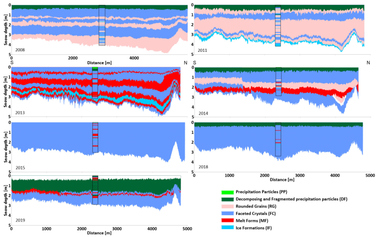
Grain shape—all types of grains excluding Surface Hoar were observed during direct observations in snow pits (Figure 4—see the vertical bar in the middle of the profiles). In the period analyzed, the years 2011, 2013, and 2014 had the most diverse range of types of snow grains: five, seven, and six types were distinguished, respectively, while in the remaining years, only four types of grains were distinguished. In 2008 and 2011 no MF were observed. In these years, no long-term thaws were observed at PPS Hornsund during the snow accumulation period (January–April) (1 day in 2008, 3 days in 2011) in contrast to the other years (e.g., 12 such days were observed in 2015). Moreover, in 2008, 2011, and 2014, Rounded Grains (RG) were observed in the snow pits, which did not occur in the other years. Along with the greater amount of meltwater, the number of pores decreased and the density increased, which is an obstacle in the formation of RG grains. Depth Hoar (DH) grains were observed as a second minority form in individual layers and in this paper, we did not consider such specific details. The IF and MF layers accounted for 14% (4% and 10%, respectively) of the snow structure in the snow pits. In 2008–2019, the number of IF layers varied between 11 (2008, 2011) and 9 (2019), with a minimum of four layers in 2013 (Figure 5—see the vertical bar in the middle of the profiles). At the same time, the total thickness of the IF layers in the seasons concerned showed a decreasing trend of 1.04 cm per decade (in 2008: 17cm of IF; in 2019: 4.5cm of IF). The number of MF layers ranged between 6 and 3. The percentage of MF layers in total HS varied between 28% (87 cm) in 2013 and 16% in 2019 (19 cm), with a minimum value of 4% in 2018 (13 cm).
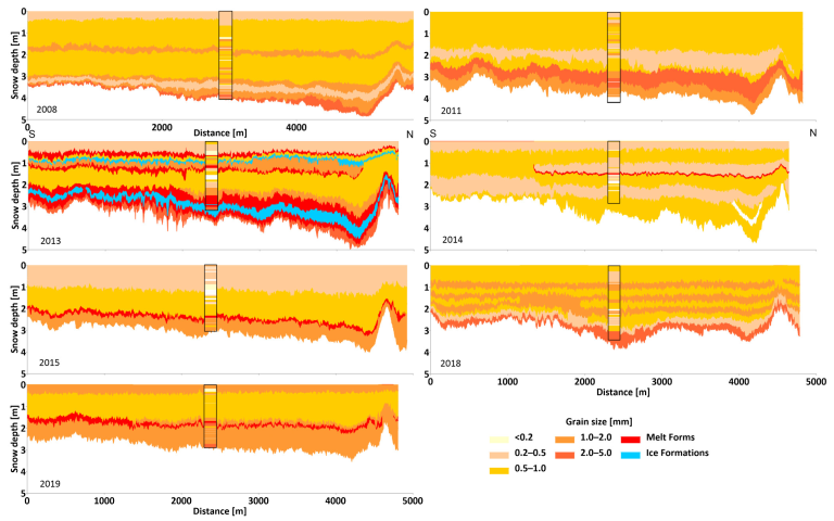
Grain size (Figure 6—see the vertical bar in the middle of the profiles)—the snow profiles were dominated by fine (0.2–0.5 mm; 30%) and medium-sized grains (0.5–1.0 mm; 30%). Coarse grains (1.0–2.0 mm) constituted 17% of snow pit layers, very fine grains (<0.2 mm) constituted 6%, and very coarse grains constituted (2.0–5.0 mm) 5%. Layers with an undefined grain size represented 11% of the snow profiles and concerned hard layers (HL) (MF and IF) where grains were hard or impossible to distinguish. There was no extreme-grained (>5 mm) snow.
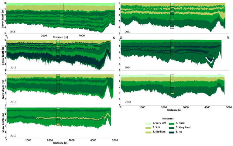
Hardness (Figure 7—see the vertical bar in the middle of the profiles)—the most frequently observed hardness classes in the snow pits were “hard” (37%) and “very hard” (33%), which correspond to snow with an average density of 402 kg m−3 and 464 kg m−3, respectively. Both hardness classes were primarily represented by the layers made by Faceted Crystals (FC) grains. A “medium” class was also usually observed in the FC layers, with an average density of 335 kg m−3. The highest hardness index, “ice”, was found in the MF and IF layers. The lowest hardness class, “very soft”, was observed in the superficial snow (first or second layer) with snow grains of precipitation particles (PP), Decomposing and fragmented precipitation particles (DF), and FC grain types. Layers of “soft” hardness index appeared most frequently in the inner layers, but also in the superficial snow, formed by PP, DF, RG, and FC crystals.
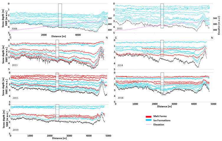
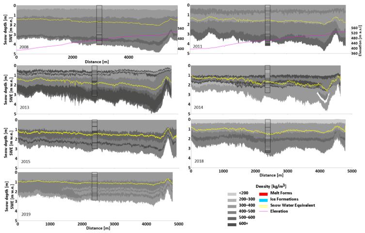
Density and SWE (Figure 8—see the vertical bar in the middle of the profiles)—the mean snow density in the snow pits ranged from 381 kg m−3 in 2019 to 459 kg m−3 in 2013 with an average of 422 kg m−3. The density of the superficial layers did not exceed 290 kg m−3 and was made of PP, DF, and FC grains. The highest density, from 600 kg m−3, was found in many of the inner layers of MF or IF types. The most often observed density was in the range 400–499 kg m−3 with snow grains of DF, RG, FC, and MF types. The mean snow density for the entire period of observations was 422 kg m−3. The SWE ranged from 1.10 m w.e. to 1.70 m w.e., with a mean value of 1.39 m w.e.

4.2. The Internal Structure of Snow Cover Derived from the GPR Survey

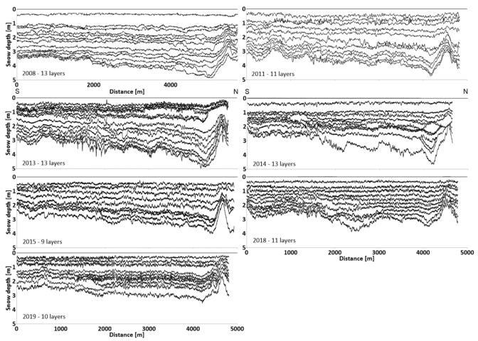
Snow cover layers were distinguished on the GPR profiles based on the contrast in dielectric properties. The analysis of GPR profiling allowed us to distinguish 80 layers of snow (38%) overall out of the 208 layers separated in snow pits (Table 2). Most of the layers were continuous, with just isolated cases of discontinuous layers present (Figure 2). Then, the physical features from the snow pit were assigned to given layers on the GPR profile.

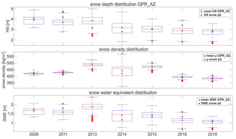
4.3. The Properties of the Snow Layers in the GPR Profiles

In Figure 3 we present the distribution of GPR-derived HS, snow density, and SWE along the GPR_AZ profile. The HS averaged over the centerline GPR_AZ profile had the greatest values of 3.91 m in 2008 and the lowest average was in 2019—2.76 m. As for HS, in all of the seasons investigated, the mean HS was close to the distribution median. What is worth noting is the shift in both mean and median HS between the 2013 and 2014 seasons (Figure 3). The average GPR_AZ HS for the entire period investigated was 3.3 m (Table 2). In four years out of seven, the HS measured in the snow pits was higher than the values calculated for GPR_AZ. The correlation coefficient for the HS value obtained from the observation in snow pits and retrieved from the GPR profiles was high (0.75). This is also reflected in the difference in average HS for snow pits and GPR_AZ in the period analyzed, which was 0.05 m (1.5%). The correlation coefficient between layers in the snow pit and layers in GPR_AZ was the highest (0.95) for the hardness parameter. For snow density this coefficient was 0.72.
Grain shape
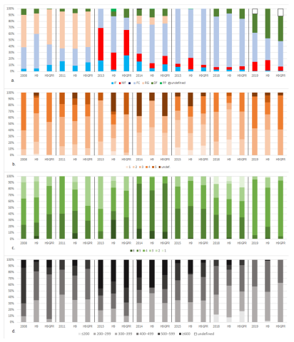
In the snow layers identified in the GPR profiles, to which the grain shapes seen in the snow pits were assigned, the predominant grain shape was (FC) with an average of 51% occurrence in the total thickness in GPR_AZ (Figure 9a). This form was observed at all depths in the snow cover (Figure 4). The highest percentage of FC was in 2015 and 2018—88% and 81%, respectively (Figure 9a). The second most common grain shape (18%) was (RG) which contributed more than half of the snow cover in 2008 and 2011. A significant share of DF was recorded in 2019 when they comprised 30% of the snow cover. PP were not distinguished on the GPR profiles. Due to the clarity of the interpretation, only the layers with their top and bottom distinguished are shown in Figure 4. In addition, 1% of the snow layers were undefined/unknown with no grain shape parameter assigned due to the lack of an equivalent layer in the snow pit.
IF and MF are presented together (Figure 5) as they both could have been formed under the influence of similar factors such as positive temperature or rain-on-snow [8]. The IF and MF layers accounted for 19% (8% and 11%, respectively) of the snow cover along the centerline.
Grain Size
Most of the layers (62% of the total thickness) in the snow structure in GPR_AZ had an average grain size smaller than 1 mm (Figure 6). The FC, which was the prevalent form, had an average size of 0.5–1.0 mm. This was reflected along the entire centerline in the accumulation part of Hansbreen, where 39% of the grains of snow had a size of 0.5–1.0 mm. This size also dominated on GPR profiles in the surroundings of snow pits (Figure 9b). Such grains were mostly found in the middle or lower part of the snow column. The second most common size range was 1–2 mm (26%).
Generally, layers with larger grains had a deeper position in the snowpack column, than layers made of smaller grains. Sometimes, such as in 2018, layers made up of smaller (0.2–0.5 mm) and bigger grains (1.0–2.0 mm) were interspersed on most of the centerline. The least variable in terms of grain size was in 2014, when only two sizes occurred (<0.2 mm and 0.2–0.5 mm). The MF consisted of polycrystals with an average size of 1–2 mm, if assigned—mostly they were not. In 2013, layers with an unidentified grain size (MF and IF) accounted for 37% of the profile.
Hardness
The most frequently estimated hardness classes in the snow layers of Hansbreen GPR_AZ were “hard” (43%) and “very hard” (34%) (Figure 9c). “Hard” layers were primarily associated with RG and FC. Generally, harder layers had a lower position in the snowpack column than those of lower hardness value (Figure 7). In some cases, similar to the grain size structure mentioned above, layers of different hardness were interspersed with each other (2008, 2011, 2013, 2014, 2015).
The “very soft” layers were only found in the superficial snow, but the “soft” layer was present both at the surface and in numerous internal layers (Figure 7). “Medium” hardness layers occurred at each level in the snowpack: superficial, inner, and bottom. The hardest layers (“very hard”) had the greatest thickness in the lower part of the profile (2013).
Density and SWE
The density arrangement of snow layers was similar to that of the hardness parameter. The thickest high-density layer (similar to the thickest high-hardness layer) was in the lower part of the snowpack in 2013 (Figure 8). It was not always the deepest layers that were denser (e.g., 2014). In some parts of the snowpack, such as the upper part in 2013 and the inner part in 2014, high-density layers were located between low-density layers.
Most of the snow cover was formed of layers with density of 400–499 kg m−3 and 300–399 kg m−3 (33% and 31%, respectively). Except for 2008 and 2013 when layers with density values ≥500 kg m−3 were dominant, one of the above types of layers had the highest frequency in each season (Figure 9d). Snow of the lowest density (<200 kg m−3) only occurred in the superficial layer (2018), but layers with a density of 200–299 kg m−3 also appeared in the middle of the profile (2014), and layers of 300–399 kg m−3 even occurred at the bottom (2019).
Similar to HS, the shift in both mean and median density and SWE between seasons 2013 and 2014 was clearly visible (Figure 3). In the series of snow densities analyzed, the highest variability was recorded in 2014; however, the median density for this season was a bit below the median density for the seasons 2013 and 2015 (Figure 3). The difference in average snow density between 2008 and 2019 for GPR_AZ was 9% (420 kg m−3 and 384 kg m−3, respectively; 6 kg m−3 per year). The highest value, 487 kg m−3 was in 2013. The non-parametric modified Mann–Kendall test [103] showed no statistically significant trend in 2008–2019 (α = 0.05). The Sen’s slope was −16.6 for density for the snow pit and −37.8 for GPR_AZ.
SWE in the GPR_AZ dropped by 35%, from 1.64 m w.e. in 2008 to 1.06 m w.e. in 2019 (0.05 m w.e. per year). This process intensified after 2013 with a rate of SWE decrease of 0.14 m w.e. per year.

5. Discussion

5.1. Limitations of the Transfer of Snow Properties between the Snow Pit and the GPR Profile

The extrapolation of snow cover features over the GPR profile was based on one snow pit. It should be noted that the description of snow layers by the observer may to some extent have been subjective, burdened by possible error. In this study, we assumed the description of snow stratigraphy by the observer as certain. However, we should strongly emphasize the need for an exchange of experiences, significant consolidation, and collaboration in the separation and analysis to properly distinguish between layers and assign them properties in the snow pit.
The procedure for assigning the snow properties observed in the snow pit to the GPR profile layers was generally not in doubt. The 2014 season was the only season in which a layer was found that was not identified in the snow pit, situated below the ice divide in the area with the highest HS (see Figure 4 and Figure 6, Figure 7 and Figure 8). It was 411 m in length and had an average thickness of 0.24 m. In the vast majority of other cases, the layers were continuous (Figure 2). This allowed us to assume that the H9 snow pit was representative of the entire centerline of the Hansbreen accumulation zone. Nevertheless, an additional snow pit could provide positive confirmation of the validity of the profiles.
Some limitations of the analysis may have resulted from the vertical resolution of the GPR antenna (0.05 m for 800 MHz). The choice of antenna affects the quality of measurements, penetration depth, and image noise [104]. The consequence of the choice was an inability to separate all the snow layers. The possibility of separation of snow layers also depends on the difference in the adjacent layers’ parameters (dielectric constant). The HLs showed clear reflections [105] and contributed to the distinction of 69% of the snow layers. However, it was usually impossible to indicate every layer’s roof or foot. A layer of the GPR profile limited at the top and bottom by HLs was assigned the dominant parameters (based on the weighted average) identified in the layers between them in the snow pit. The lack of distinguishing between layers with similar properties may be due to the difficulties associated with more subtle density transitions between layers [106]. On the ice divide, where the HS was much shallower due to blowing out, we encountered trouble with the interpretation of the layering, possibly due to their thinness and overlapping radar reflections.
The correctness of assigning snow properties to GPR layers may also be influenced by the time shift between digging snow pits and radar sounding. In 2013, 2014, 2015, and 2019, the soundings were carried out a few weeks earlier than the snow pit, but only in the first two seasons was there a clear difference in HS noted.
The snow pits and cores were also applied to validate the HS derived from GPR sounding. It should also be noted that we assumed a constant radar wave velocity for all seasons and snow layers (0.21 m ns−1). A thorough examination of the variation of radar wave velocity in individual years and layers is desirable in order to improve the accuracy of snow studies performed by RES.

5.2. Validation of Selected Snow Cover Features

Doubts regarding the correctness of the assumption of the continuity of snow cover features extrapolated from a single snow pit along the GPR profile were verified by a comparison of selected snow characteristics in snow cores and the nearest sections of GPR profiles. The evaluation included the HS, average snow density in the vertical profile, density in the sample segments, and layout of the hard layers.
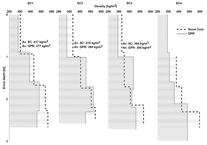
The HS derived from the snow pit and the nearest section of the GPR profile differed by only 1 cm. On the other hand, the differences in the HS based on snow cores (SC1, SC2, SC3, SC4) and GPR varied between 0.08 m (3.0%—SC1) and 0.25 m (9.6%—SC4), and in each case, the HS from the core was smaller (Figure 10). This phenomenon is explained by the additional compaction of the snowpack during core extraction. The results obtained were significantly affected by the spatial variability of snow distribution. The greatest difference in HS determined from the core and the GPR occurred where the snow core was the farthest from the GPR profile (distance: 113 m).
The overall bulk snow density based on GPR differed from that calculated for snow cores by less than 10% (Figure 10). In the case of SC1 and SC2, the GPR density was lower by 9.6% and 3.9%, respectively, while at the SC3 site, the GPR density was higher by 2.6%. In the case of SC4, such verification was impossible due to the lack of snow density in the upper 1 m long core segment. The snow density calculated for the individual snow core segments was also compared with the average density of the respective snow layers based on GPR, obtaining a correlation coefficient of r = 0.8. On average, the snow density in the snow core segments was 8.3% higher than based on the GPR, which resulted from the inability to identify all HLs with higher density in the GPR profile due to the vertical resolution of the sounding. The greatest difference in snow core–GPR density was noted for the second segment from the top of SC3 (snow density based on GPR was 24.8% higher than in the snow core segment) and the deepest segment of SC4 (snow density based on GPR was lower by 19.2% than in the snow core segment). It is worth noting that SC4 was the farthest from the GPR profile, which also explains the lower consistency of snow characteristics than those recorded at other coring sites. The density pattern in the snow cores and the accompanying GPR profiles was similar and tended to increase with depth. Considering that the measurement of the volume and weight of snow core segments was subject to an error that may have reached several percent, the results obtained in comparing the density in snow cores and the nearest fragment of the GPR should be considered satisfactory.
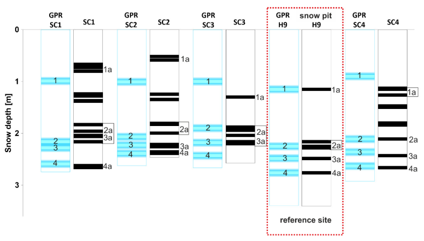
The arrangement of snow layers was verified by comparing the occurrence of HLs in snow cores and the corresponding GPR profiles (Figure 11). HLs in the GPR profile were visually identified and correlated with the occurrence of similar layers in the snow pit at the H9 reference point. Five HLs were identified in the snow pit, corresponding to four layers on the GPR profile. The lack of identification of all HLs on the GPR profile was related to the vertical resolution of the imaging. In the GPR profile, it is not possible to separate layers with too a small thickness and to separate layers lying in close proximity. Knowledge of these properties of radar imaging explains the differences between the presence of layers in GPR profiles and snow cores. At sites SC1, SC2, and SC4 on the GPR profiles, HLs present in the cores between layers 1 and 2 were not identified (Figure 11). Layer 2, visible on the GPR profile, corresponded to a set of two HLs in the SC2 core. At sites SC1 and SC3, layers 2 and 3 visible on the GPR profile correspond to sets of HLs in the depth range of 1.90–2.16 m and 1.88–2.20 m, respectively. In the SC3 core, the lowest layer 4, visible in the GPR profile, was not identified due to integration with the underlying firn.
The location of HLs in the GPR profiles was also verified and compared to the snow cores (Figure 11). Due to the vertical resolution of the soundings and possible disturbances in the snow structure in the core during its collection, in further analysis, we will consider the location of the HL as fully consistent if the difference between the snow core and the GPR profile is less than 0.1 m. At the SC1 site, layer 4 showed a consistent position, and layers 1, 2, and 3 were identified on the GPR profile lower than in the core by approximately 0.3 m. At sites, SC2 and SC4 layers 2, 3, and 4 were at the same level in the snow core and the GPR profile. In the case of SC2, layer 1 on the GPR lay approximately 0.4 m lower than its location in the snow core and on SC3 and SC4 they were 0.30 and 0.23 m higher, respectively. At site SC3, a consistent location of layers 2 and 4 was identified. Summing up, out of 15 HLs or complexes of HLs identified in snow cores and GPR profiles, 9 were found to have a consistent location (differing less than 0.1 cm).
The above considerations confirmed the existence of a significant correspondence between snow characteristics such as HS and density and the presence of HLs extrapolated along the GPR profile and marked in snow cores. Other snow properties were not determined in the validation cores. Therefore, it was impossible to confirm compliance with the characteristics of the GPR profile directly. Assuming, however, that snow properties such as density, hardness, grain size, and form are intercorrelated [1], it can be assumed that the procedure adopted above provides a premise confirming the correctness of the determination of snow characteristics along the GPR profile analyzed.

5.3. General Regularities in the Structure of the Snow Cover

The snow profiles shown in Figure 2, Figure 4, Figure 5, Figure 6, Figure 7 and Figure 8 represent the snow cover over 11 years at the end of the accumulation season. The sequence of layers, in most cases, showed a similar pattern.
The surface layers were most often composed of DF that underwent metamorphism by rounding PP forms. In the case of thin subsurface layers (1 cm or 13 cm), they were still made of PP forms, so the snowfall was relatively fresh, and they had not yet had time to evolve. Snow profiles with top PP layers and a domination of DF interspersed with IF were recorded in the spring of 2014 on the glaciers of Western Spitsbergen, Irenebreen, and Waldemarbreen (where RG also occurred) [55]. The number of IF layers was lower there than in the case of Hansbreen, but they were of greater thickness. Many HLs on Hansbreen may be related to the increase in the rain-on-snow phenomenon during accumulation seasons since 1978 in south Spitsbergen, as shown by [26], or by more frequent episodes of high temperatures in Hornsund [24]. A significant number of IF on Hansbreen in 2010 was also noted by the authors of [43], especially in the ablation zone, where they were of greater thickness. A similar arrangement of layers occurred at Midtre Lovenbreen, western Spitsbergen [107].
The lower layers of snow cover mainly consisted of FC (2013–2019) (Figure 4). In 2008 it was RG, and in 2011 IF, caused by a few days of thaw at the beginning of the accumulation season (October 2010). Then these layers were interspersed with IF or MF. The repeatability of the sequence of FC (and DH) layers with MF and IF layers was also noted on Kongsbreen in Brøggerhalvøya, located in western Spitsbergen [9].
The dominant number of FC layers in the snow cover indicated a temperature gradient sufficiently high to reduce the thickness of the layers with kinematic crystal growth [1] by the diffusion of water vapor between the grains [8]. In 2008 and 2011, more RG layers indicated lower temperature gradients, similar to 2019, due to the significant presence of DF layers.
The arrangement of layers in terms of hardness and density parameters was convergent. The mean correlation coefficient of these two parameters was 0.87. The highest correlation, 0.96, occurred in 2013, when the contribution of HLs to the snow cover was also the highest (Figure 12) and amounted to 30% of the HS. The lowest correlation, 0.75, occurred in 2015, which also indicated a significant share of HLs, mostly MF of moderate hardness (4—hard).
By default, snow density and hardness increase with depth due to compaction by the overlying layers. The snow cover stratigraphy on Hansbreen in most seasons presented a different arrangement. The layers of higher density and hardness occurred both in the lower and middle part of the snow profile and were interspersed with layers with lower values of these parameters. A similar configuration could be seen for the grain size. The formation of such a system is determined by the presence of IF layers, which protect the lower layers of snow against the pressure of the overlying layers, limiting compaction, as pointed out by Sobota [42]. Furthermore, the IF layers have strong bonds hindering the circulation of air and water vapor, which in turn slows down snow metamorphism. The denser layers over the less dense ones were also noted in the accumulation area on glaciers in the Kaffiøyra region (Elizebreen, Irenebreen, and Waldemarbreen) [55], as well as on Brøggerhalvøya [9].
The thickest layer with the highest values of hardness (6—ice layer) and density (≥600 kg m−3) was the lowest, 53 cm layer in 2013. It consisted of 50 cm MF, 3 cm IF, and was created during intense rainfalls between 31 December 2012 and 6 January 2013 [24]. This was reflected in the high bulk density (ρs) of the entire snow cover. The layers with the lowest hardness (1—very soft) and density values (<200 kg m−3) only appeared as the surface layer in 2018. In the remaining seasons, the surface layers had higher parameters due to wind action.
Figure 9 summarizes the contribution of individual parameters in snow cover (grain shape and size, hardness, and density) in the H9 snow pit, a GPR section (H9GPR—80 traces) made near the snow pit and averaged values along the entire GPR profile (GPR_AZ). There was a significant agreement between the results obtained in the same season in the snow pit and the GPR profile (both on the closest section to the snow pit and along the entire GPR_AZ profile). The above characteristics confirmed that the observation of snow at the H9 site can be considered representative of the center line of the accumulation field and, in a broader sense, of the entire accumulation zone.

5.4. HS and AR Characteristics

In classical terms, the HS increased with elevation due to the precipitation gradient. In the upper part of the Hansbreen, a depression in HS was regularly observed in each successive season (cf. e.g., Figure 2, Figure 4, Figure 5, Figure 6, Figure 7 and Figure 8, profile section between 4000 and 5000 m). The reduction in HS resulted from snow blowing away from the ice divide area [35,73]. This phenomenon was reflected in the moderate correlation coefficients (r) between the elevation and the HS in individual seasons ranging from 0.25 (2013 and 2018) to above 0.55 (0.71 in the 2008 season). The correlation coefficient r refers to the center line in the accumulation field in the elevation range between approx. 390 and 530 m a.s.l., and was lower than for the entire altitude profile of the glacier [35,71,73]; however, it was statistically significant at the level of p = 0.01. The average HS and the accumulation rate (AR) also varied in individual seasons (Table 2). The average HS showed a downward trend in successive seasons of the period analyzed. The highest average HS was recorded in the 2008 season (3.91 m), and the lowest in 2019 (2.76 m). The mean AR ranged between 0.26 m (2018) and 0.98 m (2014) of snow per 100 m elevation increase. Seasons with a significant disturbance of the relationship between the elevation and HS (2013 and 2018) (apart from the HS depression in the area of the ice divide) had local anomalies of snow accumulation caused by snow redeposition due to wind impact as a result of which the averaged AR was low (0.33 and 0.26 m of snow per 100 m in elevation, respectively). AR in the accumulation zone was lower than the average for the entire elevation profile in the seasons in which there were significant HS anomalies (e.g., in 2013 the average AR in the accumulation zone was 0.33 m/100 m elevation, and for the entire glacier it was 0.73 m/100 m elevation—Grabiec 2017) and higher in the seasons when disturbances in the elevation–HS relationship were smaller (e.g., in 2014 the average AR in the accumulation zone was 0.72 m/100 m elevation, and 0.54 m/100 m elevation for the entire glacier—Grabiec et al. 2011).

5.5. Factors Influencing Bulk Density and Its Spatial and Temporal Variability

The bulk density (in relation to the entire snow column) significantly differed in individual seasons and in space. The averaged ρs for the profile examined ranged between 384 kg m−3 (2019) and 487 kg m−3 (2013) (Figure 12). The seasons analyzed could be divided into two distinct categories, with a ρs > 440 kg m−3 (2013, 2014, 2015) and with a lower density (other seasons). In the seasons with a high ρs, a significant contribution of HLs was noted in the profile (Figure 12). In 2013 and 2015, HLs constituted c. 30% of the HS. In 2014 the percentage of HL (MF + IF) was lower (c. 13%); however, the contribution of IF only, which is the densest form in the snow cover, was more than 5% of HS. Additionally, in 2013, a high ρs was accompanied by a significant HS. This translated directly into SWE values (Figure 8 and Figure 10). Assuming an average HS in the seasons examined, 3.32 m at the ρs mentioned above, SWE could have values between 1.27 and 1.71 m. The possibility of such a wide range of SWE with the same HS indicates the need to pay significant attention to the use of snow ρs related to the right time and place when calculating the SWE. The results confirmed the general increase in ρs with HS reported in the literature e.g., [108,109,110], due to compaction under the pressure of overburdened snow layers [111]. In 2014 and 2018, the increase in ρs along with the recorded HS was the most pronounced and amounted to 22.1 and 19.2 kg m−3 per 1 m of HS, with r = 0.30 and 0.83, respectively. In the remaining seasons, the relationship between ρs and HS ranged between 9.1 and −7.3 kg m−3 per 1 m change in HS. The relationship of ρs with elevation was only indirect, based on the increase in snow accumulation with elevation, which translated into ρs. As a result, ρs increased to an elevation of 460–480 m a.s.l., and then decreased in the highest parts of the glacier, where the HS decreased due to blowing out. In standard glacier mass balance monitoring, ρs is measured at reference points (snow pits) or the ρs reference value is most often assumed. The results obtained in this study prove a significant interseasonal and spatial variability of ρs. Using reference ρs values related to a larger area may cause significant errors in calculating the winter balance of glaciers. The results presented make it possible to use more accurate data on snow density related to the center line of the glacial accumulation field.

5.6. Temporal and Spatial Variability of SWE

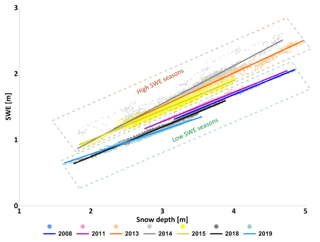
A two-dimensional variability of the SWE was obtained using the densities assigned to individual layers separated from the GPR profiles. Its distribution refers to the snow depth field; however, it is modified by the spatially variable ρs, which results from the density of individual layers and their thickness. The highest ρs observed in 2013 meant that the average SWE in this season was the highest (1.87 m w.e.), even though a greater HS was recorded in 2008. The smallest SWE (1.06 m w.e.) was in 2019 due to the minimum values of HS and ρs. SWE showed a very close relationship with the HS (r > 0.95 in all seasons—see Figure 13). However, due to the different ρs in individual seasons, the SWE gradient with the HS was between 0.36 (2019) and 0.50 m w.e. (2014, 2015) for a change in HS by 1 m (0.46 m w.e. on average).

5.7. The HLs in Nival Systems of Glaciers

The occurrence of warm episodes and ROS phenomena is reflected in the snow cover [27] and constitutes an essential indicator of progressive climate change [26,55]. Although we studied the snow cover in the elevated accumulation zone, we found numerous IF and MF layers (Figure 12). These structures, called HLs, are formed on or below the snow surface by freezing or refreezing melt- or rainwater under similar conditions, i.e., at periods of snowmelt and refreezing, by ROS phenomena, or when both factors coincide. By analyzing data from the Hornsund meteorological site [94] and assuming a vertical temperature gradient of 0.66 100 m−1 [112], a significant dependence between days or periods with positive air temperature and the number or thickness of HLs can be seen for most seasons (2008, 2013, 2014, 2018, 2019). A different temperature gradient may have occurred in the remaining seasons. A similar relationship referring to Hansbreen was reported by Łupikasza et al. [26] and to Waldemarbreen, Irenebreen, and Elisebreen (western Spitsbergen) by Sobota [55]. In addition, Laska et al. [43] for Hansbreen and Sobota [55] for the glaciers in the Kaffioyra region showed that IFs were more common in the ablation zone.
Climate warming leads to more frequent thaw episodes and rainfall during the snow cover formation period [36], even in the high accumulation zones of the Svalbard glaciers. This leads to an increase in the number of IF and MF layers. In our study, numerous HLs were observed, ranging from 9 in 2013 and 2018 to 13 in 2015 (Figure 13). The HL contribution to the HS varied from 3.1% to 30.2%. This should be interpreted as an effect of short- or medium-term winter warm spells, resulting in numerous HL of variable thickness formation. Historical data from the end of the 1980s [65] from Hansbreen’s ice divide show the absence of IF layers and a smaller number of MF layers in the snow cover than in contemporary studies in which both occurred in the ablation zone.
HLs are essential for the functioning of the nival and glacial systems. The IF layers conserve the snow cover, limiting the ability of wind-forced redeposition [42,65]. It may also result in extended retention and limited outflow of meltwater from the snow cover [1,35]. The HL complex in the snow cover forms a framework that protects against excessive compaction, water percolation, and penetration of water vapor, which may result in a reduction in wet metamorphosis in layers under HLs or a slower rate of heat transfer. The influence of IF on temperature changes is not entirely clear. The increased contribution of HLs to the snow cover enhances the overall thermal conductivity of the snowpack, enabling heat transfer within the snow cover. On the other hand, HLs block water vapor and meltwater migration, which effectively transfers heat. This has serious glaciological consequences for the thermal structure of the glacier and the rate of internal accumulation by meltwater refreezing, which due to its complexity, requires further detailed studies. Similarly, the influence of HLs on ρs is not fully understood. On the one hand, HLs have a higher density than the other layers. On the other, they can limit compaction. Decreasing ρs in response to the increase in the number of rain-on-snow events was recorded by Sobota et al. [42] on glaciers of NW Svalbard (Waldemarbreen and Irenebreen).

6. Conclusions

  • The snow cover structure is variable in space and from season to season. The extrapolation of snow pit data through radar profiling is a novel solution that can improve the spatial recognition of snow cover characteristics and the accuracy of SWE calculations;
  • The location of the H9 snow pit was representative of the center line in the accumulation zone of Hansbreen;
  • The snow cover layers were predominantly continuous, with just isolated cases of discontinued ones. Difficulties in identifying layers mainly occurred in the ice divide due to the reduction in the HS and individual layers due to blowing out;
  • In 2008–2019 HS showed a downward trend. The mean AR along the center line of the accumulation field was lower than the average for the entire Hansbreen, mainly due to the atypical reduction in the HS in the most elevated areas of the ice divide;
  • FC layers predominated in the snowpack structure (51% on average). The standard snowpack structure included DF (or PP) at the top and FC (or RG) at the bottom. The layers were separated by inserts of IF and MF layers (especially in the lower part of the profile). Harder and denser layers occurred in the middle and lower parts and were interspersed with layers of lower density and hardness;
  • Numerous HLs were observed in the accumulation zone along the center line (contributing up to 30% of the snow column), but there was no trend in quantity, thickness, or percentage contribution to total snow depth. The substantial HL contribution to the snowpack significantly increased the bulk density.
  • IF layers form barriers for air and water vapor circulation within the snowpack and for the percolation of rain or meltwater. HLs with strong crystal bonds create a “frame” in the snowpack, which reduces compaction. As a consequence, IF layers slow down the rate of metamorphosis of the snowpack.

Author Contributions

Conceptualization, M.G. and K.K.; methodology, K.K. and M.G.; software, K.K.; validation, K.K.; formal analysis, K.K. and M.G.; data acquisition, M.G., D.I., M.L. and B.L.; data curation, K.K.; writing—original draft preparation, K.K.; writing—review and editing, M.G., K.K., D.I., M.L. and B.L.; visualization, K.K. and B.L.; supervision, M.G. and D.I. All authors have read and agreed to the published version of the manuscript.

Funding

The field data collection and/or processing received grant aid from: the National Centre for Research and Development within the Polish-Norwegian Research Cooperation Programme (AWAKE2 project Pol Nor/198675/17/2013), Polish-Norwegian funding (AWAKE project PNRF-22-AI-1/07), Polish Ministry of Science and Higher Education (GLACIODYN No. IPY/269/2006), Polish National Centre for Research and Development (SvalGlac project No. NCBiR/PolarCLIMATE-2009/2-2/2010), European Union 7th Framework Programme (ice2sea programme, grant no. 226375, contribution no. 108). Glaciological data were processed under assessment of the University of Silesia data repository within project Integrated Arctic Observing System (INTAROS, European Union’s Horizon 2020 Research and Innovation Programme—grant No. 727890). The work was supported by the Centre for Polar Studies (the Leading National Research Centre in Earth Sciences for 2014–2018) funding, No. 03/KNOW2/2014.

Data Availability Statement

Much of data used in this paper are free and available online on the website of Polish Polar Database: (1) most of the snow depth data obtained by high frequency GPR (https://ppdb.us.edu.pl/geonetwork/srv/eng/catalog.search#/metadata/1be8f239-d91a-4abd-9c3c-e66792bd9c89, accessed on 29 September 2022); (2) most of the physical features of the snow cover on H9 snow pit site (https://ppdb.us.edu.pl/geonetwork/srv/pol/catalog.search;jsessionid=8942E33248154814B26460439A892C57#/metadata/8c7f8676-c9d9-4493-8f45-fbe4a25f849b, accessed on 29 September 2022).

Acknowledgments

The authors would like to acknowledge Dariusz Puczko (Institute of Biochemistry and Biophysics Polish Academy of Sciences; Institute of Geophysics Polish Academy of Sciences) for sharing snow pit data from seasons 2008 and 2011, as well as Barbara Barzycka (University of Silesia in Katowice) for sharing snow core data from season 2018. The studies were carried out as part of the scientific activity of the Centre for Polar Studies (University of Silesia in Katowice) with the use of research and logistic equipment (ground-penetrating radar, GNSS receiver, snow mobiles) of the Polar Laboratory of the University of Silesia in Katowice.

Conflicts of Interest

The authors declare no conflict of interest.

References

  1. Armstrong, R.L.; Brown, R. Introduction. In Snow and Climate. Physical Processes, Surface Energy Exchange and Modelling; Armstrong, R.L., Brun, E., Eds.; Cambridge University Press: Cambridge, UK, 2008; pp. 1–11. [Google Scholar]
  2. Warren, S.G.; Rigor, I.G.; Untersteiner, N.; Radionov, V.R.; Bryazgin, N.N.; Aleksandrov, Y.I.; Colony, R. Snow depth on arctic sea ice. J. Climate 1999, 12, 1814–1829. [Google Scholar] [CrossRef]
  3. Cohen, J.L.; Rind, D. The effect of snow cover on the climate. J. Climate 1991, 4, 689–706. [Google Scholar] [CrossRef]
  4. Jonsell, U.; Hock, R.; Holmgren, B. Spatial and temporal variations in albedo on Storglaciären, Sweden. J. Glaciol. 2003, 49, 59–68. [Google Scholar] [CrossRef] [Green Version]
  5. Fujita, K. Influence of precipitation seasonality on glacier mass balance and its sensitivity to climate change. Ann. Glaciol. 2008, 48, 88–92. [Google Scholar] [CrossRef] [Green Version]
  6. Benn, D.I.; Evans, D.J.A. Glaciers and Glaciation, 2nd ed.; Hodder Education: London, UK, 2010; 816p. [Google Scholar]
  7. Colbeck, S.C. An overview of seasonal snow metamorphism. Rev. Geophys. 1982, 20, 45–61. [Google Scholar] [CrossRef]
  8. Fierz, C.; Armstrong, R.L.; Durand, Y.; Etchevers, P.; Greene, E.; Mcclung, D.M.; Nishimura, K.; Satyawali, P.K.; Sokratov, S.A. The International Classification for Seasonal Snow on the Ground; IACS Contribution, No. 1; UNESCO-IHP: Paris, France, 2009; p. 90. [Google Scholar]
  9. Valt, M.; Salvatori, R. Snowpack characteristics of Brøggerhalvøya, Svalbard Islands. Rend. Fis. Acc. Lincei 2016, 27 (Suppl. S1), 129–136. [Google Scholar] [CrossRef]
  10. Cuffey, K.M.; Paterson, W.S.B. The Physics of Glaciers; Academic Press: London, UK, 2010; 704p. [Google Scholar]
  11. Callaghan, T.V.; Johansson, M.; Brown, R.D.; Groisman, P.Y.; Labba, N.; Radionov, V.; Barry, R.G.; Bulygina, O.N.; Essery, R.L.; Frolov, D.M.; et al. The Changing Face of Arctic Snow Cover: A Synthesis of Observed and Projected Changes. AMBIO 2011, 40, 17–31. [Google Scholar] [CrossRef] [Green Version]
  12. Moreno, R.M.; Canadas, E.S. Snow cover evolution in the High Arctic, Nordenskiöld Land (Spitsbergen, Svalbard). Bol. Asoc. Geógr. Esp. 2013, 61, 409–413. [Google Scholar]
  13. Jansson, P.; Hock, R.; Schneider, T. The concept of glacier storage: A review. J. Hydrol. 2003, 282, 116–129. [Google Scholar] [CrossRef]
  14. Hodgkins, R.; Cooper, R.; Wadham, J.; Trantner, M. Interannual variability in the spatial distribution of winter accumulation at a high-Arctic glacier (Finsterwalderbreen, Svalbard), and its relationship with topography. Ann. Glaciol. 2005, 24, 243–248. [Google Scholar] [CrossRef] [Green Version]
  15. Decaux, L.; Grabiec, M.; Ignatiuk, D.; Jania, J. Role of discrete water recharge from supraglacial drainage systems in modeling patterns of subglacial conduits in Svalbard glaciers. Cryosphere 2019, 13, 735–752. [Google Scholar] [CrossRef]
  16. Barbaro, E.; Koziol, K.; Björkman, M.P.; Vega, C.P.; Zdanowicz, C.; Martma, T.; Gallet, J.-C.; Kępski, D.; Larose, C.; Luks, B.; et al. Measurement report: Spatial variations in ionic chemistry and water-stable isotopes in the snowpack on glaciers across Svalbard during the 2015–2016 snow accumulation season. Atmos. Chem. Phys. 2021, 21, 3163–3180. [Google Scholar] [CrossRef]
  17. Koziol, K.; Uszczyk, A.; Pawlak, F.; Frankowski, M.; Polkowska, Z. Seasonal and Spatial Differences in Metal and Metalloid Concentrations in the Snow Cover of Hansbreen, Svalbard. Front. Earth Sci. 2021, 8, 538762. [Google Scholar] [CrossRef]
  18. Spolaor, A.; Moroni, B.; Luks, B.; Nawrot, A.; Roman, M.; Larose, C.; Stachnik, Ł.; Bruschi, F.; Kozioł, K.; Pawlak, F.; et al. Investigation on the Sources andImpact of Trace Elements in the Annual Snowpack and the Firn in the Hansbreen (Southwest Spitsbergen). Front. Earth Sci. 2021, 8, 536036. [Google Scholar] [CrossRef]
  19. Lewandowski, M.; Kusiak, M.A.; Werner, T.; Nawrot, A.; Barzycka, B.; Laska, M.; Luks, B. Seeking the Sources of Dust: Geochemical and Magnetic Studies on “Cryodust” in Glacial Cores from Southern Spitsbergen (Svalbard, Norway). Atmosphere 2020, 11, 1325. [Google Scholar] [CrossRef]
  20. Meinander, O.; Dagsson-Waldhauserova, P.; Amosov, P.; Aseyeva, E.; Atkins, C.; Baklanov, A.; Baldo, C.; Barr, S.L.; Barzycka, B.; Benning, L.G.; et al. Newly identified climatically and environmentally significant high-latitude dust sources. Atmos. Chem. Phys. 2022, 22, 11889–11930. [Google Scholar] [CrossRef]
  21. Stocker, T.F.; Qin, D.; Plattner, G.-K.; Tignor, M.; Allen, S.K.; Boschung, J.; Nauels, A.; Xia, Y.; Bex, V.; Midgley, P.M. Climate Change 2013: The Physical Science Basis; Contribution of Working Group I to the Fifth Assessment Report of the Intergovernmental Panel on Climate Change (IPCC); Cambridge University: Cambridge, UK; New York, NY, USA, 2013; p. 1535. [Google Scholar] [CrossRef] [Green Version]
  22. Isaksen, K.; Nordli, O.; Forland, E.J.; Łupikasza, E.; Eastwood, S.; Niedźwiedź, T. Recent warming on Spitsbergen—Influence of atmospheric circulation and sea ice cover. J. Geophys. Res. Atmos. 2016, 121, 11913–11931. [Google Scholar] [CrossRef]
  23. Hanssen-Bauer, I.; Førland, E.J.; Hisdal, H.; Mayer, S.; Sandø, A.B.; Sorteberg, A. (Eds.) Climate in Svalbard 2100–A Knowledge Base for Climate Adaptation; NCCS Report 1/2019; Norwegian Centre of Climate Services (NCCS) for Norwegian Environment Agency (Miljødirektoratet): Oslo, Norway, 2019; 208p. [Google Scholar] [CrossRef]
  24. Wawrzyniak, T.; Osuch, M. A 40-year High Arctic climatological dataset of the Polish Polar Station Hornsund (SWSpitsbergen, Svalbard). Earth Syst. Sci. Data 2020, 12, 805–815. [Google Scholar] [CrossRef] [Green Version]
  25. Vikhamar-Schuler, D.; Isaksen, K.; Haugen, J.E.; Tømmervik, H.; Luks, B.; Schuler, T.V.; Bjerke, J.W. Changes in winter warming events in the Nordic Arctic Region. J. Clim. 2016, 29, 6223–6244. [Google Scholar] [CrossRef]
  26. Łupikasza, E.B.; Ignatiuk, D.; Grabiec, M.; Cielecka-Nowak, K.; Laska, M.; Jania, J.; Luks, B.; Uszczyk, A.; Budzik, T. The role of winter rain in the glacial system on Svalbard. Water 2019, 11, 334. [Google Scholar] [CrossRef] [Green Version]
  27. McBean, G. Arctic Climate: Past and Present (Chapter 2). In Arctic Climate Impact Assessment; Symon, C., Arris, L., Heal, B., Eds.; ACIA Scientific Report; Cambridge University Press: Cambridge, UK, 2005; pp. 21–60. [Google Scholar]
  28. Vickers, H.; Karlsen, S.R.; Malnes, E. A 20-Year MODIS-Based Snow Cover Dataset for Svalbard and Its Link to Phenological Timing and Sea Ice Variability. Remote Sens. 2020, 12, 1123. [Google Scholar] [CrossRef] [Green Version]
  29. Screen, J.; Simmonds, I. The central role of diminishing sea ice in recent Arctic temperature amplification. Nature 2010, 464, 1334–1337. [Google Scholar] [CrossRef] [Green Version]
  30. Serreze, M.C.; Barry, R.G. Processes and impacts of Arctic amplification: A research synthesis. Glob. Planet. Chang. 2011, 77, 85–96. [Google Scholar] [CrossRef]
  31. Maturilli, M.; Herber, A.; Konig-Langlo, G. Climatology and time series of surface meteorology in Ny-Ålesund, Svalbard. Earth Syst. Sci. Data 2013, 5, 155–163. [Google Scholar] [CrossRef] [Green Version]
  32. Hansen, B.B.; Isaksen, K.; Benestad, R.E.; Kohler, J.; Pedersen, Å.Ø.; Loe, L.E.; Coulson, S.J.; Larsen, J.O.; Varpe, Ø. Warmer and wetter winters: Characteristics and implications of an extreme weather event in the High Arctic. Environ. Res. Lett. 2014, 9, 114021. [Google Scholar] [CrossRef]
  33. Nordli, Ø.; Przybylak, R.; Ogilvie, A.E.J.; Isaksen, K. Long-term temperature trends and variability on Spitsbergen: The extended Svalbard airport temperature series, 1898–2012. Polar Res. 2014, 33, 1898–2012. [Google Scholar] [CrossRef] [Green Version]
  34. AMAP Assessment 2021: Mercury in the Arctic; Arctic Monitoring and Assessment Programme (AMAP): Tromsø, Norway, 2021; 324p.
  35. Grabiec, M. Stan i Współczesne Zmiany Systemów Lodowcowych Południowego Spitsbergenu w Świetle Badań Metodami Radarowymi [The State and Contemporary Changes of Glacial Systems in Southern Spitsbergen in the Light of Radar Methods]; Wydawnictwo Uniwersytetu Śląskiego: Katowice, Poland, 2017; 328p. [Google Scholar]
  36. Graham, R.M.; Cohen, L.; Petty, A.A.; Boisvert, L.N.; Rinke, A.; Hudson, S.R.; Nicolaus, M.; Granskog, M.A. Increasing frequency and duration of Arctic winter warming events. Geophys. Res. Lett. 2017, 44, 6974–6983. [Google Scholar] [CrossRef] [Green Version]
  37. Peeters, B.; Pedersen, A.O.; Loe, E.L.; Isaksen, K.; Veiberg, V.; Stein, A.; Kohler, J.; Gallet, J.-C.; Aanes, R. Spatiotemporal patterns of rain-on-snow and basal ice in high Arctic Svalbard. Detection of a climate-cryosphere regime shift. Environ. Res. Lett. 2019, 14, 015002. [Google Scholar] [CrossRef]
  38. Nowak, A.; Hodson, A. Hydrological response of a High-Arctic catchment to changing climate over the past 35 years: A case study of Bayelva watershed, Svalbard. Polar Res. 2013, 32, 19691. [Google Scholar] [CrossRef]
  39. Bintanja, R.; Selten, F.M. Future increases in Arctic precipitation linked to local evaporation and sea-ice retreat. Nature 2014, 509, 479–482. [Google Scholar] [CrossRef]
  40. Rennert, K.J.; Roe, G.; Putkonen, J.; Bitz, C.M. Soil thermal and ecological impacts of rain on snow events in the circumpolar arctic. J. Clim. 2009, 22, 2302–2315. [Google Scholar] [CrossRef] [Green Version]
  41. Bintanja, R.; Andry, O. Towards a rain-dominated Arctic. Nat. Clim. Chang. 2017, 7, 263–267. [Google Scholar] [CrossRef]
  42. Sobota, I.; Weckwerth, P.; Grajewski, T. Rain-On-Snow (ROS) events and their relations to snowpack and ice layer changes on small glaciers in Svalbard, the high Arctic. J. Hydrol. 2020, 590, 125279. [Google Scholar] [CrossRef]
  43. Laska, M.; Luks, B.; Budzik, T. Influence of snowpack internal structure on snow metamorphism and melting intensity on Hansbreen, Svalbard. Pol Polar Res. 2016, 37, 193–218. [Google Scholar] [CrossRef] [Green Version]
  44. Blatter, H.; Hutter, K. Polythermal conditions in Arctic glaciers. J. Glaciol. 1991, 37, 261–269. [Google Scholar] [CrossRef] [Green Version]
  45. Ahlmann, H.W. Scientific results of the Swedish−Norwegian Arctic Expedition in the summer of 1931. Part VIII. Geogr. Ann. 1933, 15, 161–216. [Google Scholar] [CrossRef]
  46. Ahlmann, H.W. The Fourteenth of July Glacier scientific results of the Norwegian–Swedish Spitsbergen Expedition in 1934. Part V. Geogr Ann. 1935, 17, 167–211. [Google Scholar] [CrossRef]
  47. Migała, K.; Pereyma, J.; Sobik, M. Snow accumulation in South Spitsbergen. In Wyprawy Polarne Uniwersytetu Śląskiego 1980–1984; Jania, J., Pulina, M., Eds.; University of Silesia: Katowice, Poland, 1988; Volume 2, pp. 48–63. [Google Scholar]
  48. Tveit, J.; Killingtveit, Ĺ. Snow surveys for studies of water budget on Svalbard. In Proceedings of the 10th International Northern Research Basins Symposium and Workshop, Spitsbergen, Norway, 28 August–3 September 1994; pp. 489–509. [Google Scholar]
  49. Grześ, M.; Sobota, I. Winter snow accumulation and winter outflow from the Waldemar Glacier (NW Spitsbergen) between 1996 and 1998. Pol. Polar Res. 2000, 21, 19–32. [Google Scholar]
  50. Sand, K.; Winther, J.G.; Marechal, D.; Bruland, O.; Melvold, K. Regional variations of snow accumulation on Spitsbergen, Svalbard in 1997–99. Hydrol. Res. 2003, 34, 17–32. [Google Scholar] [CrossRef]
  51. Małecki, J. Snow accumulation on a small high-arctic glacier Svenbreen—Variability and topographic controls. Geogr. Ann. Ser. A Phys. Geogr. 2016, 97, 809–817. [Google Scholar] [CrossRef]
  52. Möller, M.; Möller, R.; Beaudon, É.; Mattila, O.-P.; Finkelnburg, R.; Braun, M.; Grabiec, M.; Jonsell, U.; Luks, B.; Puczko, D.; et al. Snowpack characteristics of Vestfonna and De Geerfonna (Nordaustlandet, Svalbard)—A spatiotemporal analysis based on multiyear snow-pit data. Geogr. Ann. Ser. A Phys. Geogr. 2011, 93, 273–285. [Google Scholar] [CrossRef]
  53. Sobota, I. Snow accumulation, melt, mass loss, and the near-surface ice temperature structure of Irenebreen, Svalbard. Polar Sci. 2011, 5, 327–336. [Google Scholar] [CrossRef] [Green Version]
  54. Sobota, I. Współczesne Zmiany Kriosfery Północnozachodniego Spitsbergenu na Przykładzie regionu Kaffiøyry [Contemporary Changes of the Cryosphere of North-Western Spitsbergen Based on the Example of the Kaffioyra Region]; Wydawnictwo Naukowe UMK: Toruń, Poland, 2013; 449p. (In Polish) [Google Scholar]
  55. Sobota, I. Selected problems of snow accumulation on glaciers during long-term studies in north-western Spitsbergen, Svalbard. Geogr. Ann. Ser. A Phys. Geogr. 2017, 92, 177–192. [Google Scholar] [CrossRef]
  56. Sauter, T.; Möller, M.; Finkelnburg, R.; Grabiec, M.; Scherer, D.; Schneider, C. Snowdrift modelling for the Vestfonna ice cap, north—Eastern Svalbard. Cryosphere 2013, 7, 1287–1301. [Google Scholar] [CrossRef] [Green Version]
  57. Kosiba, A. Badania glacjologiczne na Spitsbergenie w lecie 1957 roku [Glaciological investigations of the Polish IGY Spitsbergen Expedition in 1957]. Prz. Geofiz. 1958, 3, 95–122, [In Polish]. [Google Scholar]
  58. Kosiba, A. Some of Results of Glaciological Investigations in SW-Spitsbergen. Carried out during the Polish I. G. Y. Spitsbergen Expeditions in 1957, 1958 and 1959; Zeszyty Naukowe. Ser. B. Nauki Przyrodnicze 4. Nauka O Ziemi, 3–14; Uniwersytet Wrocławski Im. Bolesława Bieruta/Państwowe Wydawnictwo Naukowe: Warsaw, Poland, 1960. [Google Scholar]
  59. Baranowski, S. Report on the Field Work of the Polish Scientific Expedition in 1973; Wydawnictwo Uniwersytetu Wrocławskiego: Wrocław, Poland, 1974; 29p. [Google Scholar]
  60. Baranowski, S. The subpolar glaciers of Spitsbergen seen against the climate of this region. Acta Univ. Wratislav. 1977, 410, 1–94. [Google Scholar]
  61. Jania, J. Field Investigations during Glaciological Expeditions to Spitsbergen in the Period 1992–1994; Interim Report; University of Silesia: Katowice, Poland, 1994; 40p. [Google Scholar]
  62. Grabiec, M.; Budzik, T.; Głowacki, P. Modelling and Hindcasting of the Mass Balance of Werenskioldbreen (Southern Svalbard). Arct. Antarct. Alp. Res. 2012, 44, 164–179. [Google Scholar] [CrossRef] [Green Version]
  63. Pulina, M. Stratification and physic-chemical properties of snow in Spitsbergen in the hydro-glaciological year 1989/1990. In Wyprawy Geograficzne na Spitsbergen; UMCS: Lublin, Poland, 1991; pp. 191–213. [Google Scholar]
  64. Glazovsky, A.F.; Kolondra, L.; Moskalevsky, M.Y.; Jania, J. Research into Hansbreen, a tidewater glacier in Spitsbergen. Polar Geogr. Geol. 1992, 16, 243–252. [Google Scholar] [CrossRef]
  65. Leszkiewicz, J.; Pulina, M. Snowfall phases in analysis of snow cover in Hornsund, Spitsbergen. Pol. Polar Res. 1999, 20, 3–24. [Google Scholar]
  66. Głowacki, P.; Pulina, M. The physico-chemical properties of the snow cover of Spitsbergen (Svalbard) based on investigations during the winter season 1990/1991. Pol. Polar Res. 2000, 21, 65–88. [Google Scholar]
  67. Głowacki, P. Rola Procesów Fizyczno-Chemicznych w Kształtowaniu Struktury Wewnętrzneji Obiegu Masy Lodowców Spitsbergenu [Role of Physical and Chemical Processes in the Internal Structure Formation and Mass Circulation of Spitsbergen glaciers]; Publications of the Institute of Geophysics Polish Academy of Sciences: Warszawa, Poland, 2007; pp. 1–146. (In Polish) [Google Scholar]
  68. Nawrot, A.P.; Migała, K.; Luks, B.; Pakszys, P.; Głowacki, P. Chemistry of snow cover and acidic snowfall during a season with a high level of air pollution on the Hans Glacier, Spitsbergen. Polar Sci. 2016, 10, 249–261. [Google Scholar] [CrossRef]
  69. Uszczyk, A.; Grabiec, M.; Laska, M.; Kuhn, M.; Ignatiuk, D. Importance of snow as component of surface mass balance of Arctic glacier (Hansbreen, southern Spitsbergen). Pol. Polar Res. 2019, 40, 311–338. [Google Scholar] [CrossRef]
  70. Laska, M.; Luks, B.; Kępski, D.; Gądek, B.; Głowacki, P.; Puczko, D.; Migała, K.; Nawrot, A.; Pętlicki, M. Hansbreen Snowpit Dataset—Over 30-year of detailed snow research on an Arctic glacier. Sci. Data 2022, 9, 656. [Google Scholar] [CrossRef] [PubMed]
  71. Grabiec, M.; Puczko, D.; Budzik, T.; Gajek, G. Snow distribution patterns on Svalbard glaciers derived from radio-echo soundings. Pol. Polar Res. 2011, 32, 393–421. [Google Scholar] [CrossRef]
  72. Melvold, K. Snow measurements using GPR: Example from Amundsenisen, Svalbard. In Applied Geophysics in Periglacial Environments; Hauck, C., Kneisel, C., Eds.; Cambridge University Press: Cambridge, UK, 2008; pp. 207–216. [Google Scholar]
  73. Laska, M.; Grabiec, M.; Ignatiuk, D.; Budzik, T. Snow deposition patterns on southern Spitsbergen glaciers, Svalbard, in relation to recent meteorological conditions and local topography. Geogr. Ann. Phys. Geogr. 2017, 99, 262–287. [Google Scholar] [CrossRef]
  74. Kohler, J.; Moore, J.; Kennett, M.; Engeset, R.; Elvehøy, H. Using ground-penetrating radar to image previous years summer surfaces for mass-balance measurements. Ann. Glaciol. 1997, 24, 355–360. [Google Scholar] [CrossRef] [Green Version]
  75. Winther, J.-G.; Bruland, O.; Sand, K.; Killingtveit, Å.; Marechal, D. Snow accumulation distribution on Spitsbergen, Svalbard, in 1997. Polar Res. 1998, 17, 155–164. [Google Scholar] [CrossRef]
  76. Bruland, O.; Sand, K.; Killingtveit, Å. Snow distribution at a High Arctic site at Svalbard. Nord. Hydrol. 2001, 32, 1–12. [Google Scholar] [CrossRef]
  77. Pinglot, J.F.; Hagen, J.; Melvold, K.; Eiken, T.; Vincent, C. A mean net accumulation pattern derived from radioactive layers and radar soundings on Austfonna, Nordaustlandet, Svalbard. J. Glaciol. 2001, 47, 555–566. [Google Scholar] [CrossRef] [Green Version]
  78. Taurisano, A.; Schuler, T.V.; Hagen, J.-O.; Eiken, T.; Loe, E.; Melvold, K.; Kohler, J. The distribution of snow accumulation across the Austfonna ice cap, Svalbard: Direct measurements and modelling. Polar Res. 2007, 26, 7–13. [Google Scholar] [CrossRef]
  79. Dunse, T.; Schuler, T.; Hagen, J.; Eiken, T.; Brandt, O.; Høgda, K. Recent fluctuations in the extent of the firn area of Austfonna, Svalbard, inferred from GPR. Ann. Glaciol. 2009, 50, 155–162. [Google Scholar] [CrossRef] [Green Version]
  80. Van Pelt, W.J.J.; Pettersson, R.; Pohjola, V.; Marchenko, S.; Claremar, B.; Oerlemans, J. Inverse estimation of snow accumulation along a snow radar transect on Nordenskiöldbreen, Svalbard. J. Geophys. Res. Earth Surf. 2014, 119, 816–835. [Google Scholar] [CrossRef]
  81. Singh, G.; Lavrentiev, I.; Glazovsky, A.; Patil, A.; Mohanty, S.; Khromova, T.; Nosenko, G.; Sosnovskiy, A.; Arigony-Neto, J. Retrieval of Spatial and Temporal Variability in Snowpack Depth over Glaciers in Svalbard Using GPR and Spaceborne POLSAR Measurements. Water 2020, 12, 21. [Google Scholar] [CrossRef] [Green Version]
  82. Mätzler, C. Microwave permittivity of dry snow. IEEE Trans. Geosci. Remote Sens. 1996, 34, 573–581. [Google Scholar] [CrossRef]
  83. Harper, J.; Bradford, J. Snow stratigraphy over a uniform depositional surface:spatial variability and measurement tools. Cold Reg. Sci. Technol. 2003, 37, 289–298. [Google Scholar] [CrossRef]
  84. Dunse, T.; Eisen, O.; Helm, V.; Rack, W.; Steinhage, D.; Parry, V. Characteristics and small-scale variability of GPR signals and their relation to snow accumulation in Greenland’s percolation zone. J. Glaciol. 2008, 54, 333–342. [Google Scholar] [CrossRef] [Green Version]
  85. Jania, J.; Mochnacki, D.; Gądek, B. The thermal structure of Hansbreen, a tidewater glacier in southern Spitsbergen, Svalbard. Polar Res. 1996, 15, 53–66. [Google Scholar] [CrossRef]
  86. Pälli, A.; Moore, J.C.; Jania, J.; Kolondra, L.; Głowacki, P. The drainage pattern of Hansbreen and Werenskioldbreen, two polythermal glaciers in Svalbard. Polar Res. 2003, 22, 355–371. [Google Scholar] [CrossRef] [Green Version]
  87. Ignatiuk, D.; Piechota, A.; Ciepły, M.; Luks, B. Changes of altitudinal zones of Werenskioldbreen and Hansbreen in period 1990–2008, Svalbard. AIP Conf. Proc. 2014, 1618, 275–280. [Google Scholar] [CrossRef]
  88. Błaszczyk, M.; Ignatiuk, D.; Uszczyk, A.; Cielecka-Nowak, K.; Grabiec, M.; Jania, J.A.; Moskalik, M.; Walczowski, W. Freshwater input to the Arctic fjord Hornsund (Svalbard). Polar Res. 2019, 38, 3506. [Google Scholar] [CrossRef]
  89. Grabiec, M.; Jania, J.; Puczko, D.; Kolondra, L.; Budzik, T. Surface and bed morphology of Hansbreen, a tidewater glacier in Spitsbergen. Pol. Polar Res. 2012, 33, 111–138. [Google Scholar] [CrossRef]
  90. Laska, M.; Barzycka, B.; Luks, B. Melting characteristics of snow cover on tidewater glaciers in Hornsund fjord, Svalbard. Water 2017, 9, 804. [Google Scholar] [CrossRef]
  91. Schuler, T.V.; Kohler, J.; Elagina, N.; Hagen, J.O.M.; Hodson, A.J.; Jania, J.A.; Kaab, A.M.; Luks, B.; Małecki, J.; Moholdt, G.; et al. Reconciling Svalbard glacier mass balance. Front. Earth Sci. 2020, 8, 156. [Google Scholar] [CrossRef]
  92. Błaszczyk, M.; Ignatiuk, D.; Grabiec, M.; Kolondra, L.; Laska, M.; Decaux, L.; Jania, J.; Berthier, E.; Luks, B.; Barzycka, B.; et al. Quality assessment and glaciological applications of digital elevation models derived from space-borne and aerial images over two tidewater glaciers of southern Spitsbergen. Remote Sens. 2019, 11, 1121. [Google Scholar] [CrossRef]
  93. Niedźwiedź, T. The atmospheric circulation. In Climate and Climate Change at Hornsund, Svalbard; Marsz, A.A., Styszyńska, A., Eds.; Gdynia Maritime University: Gdynia, Poland, 2013; pp. 57–74. [Google Scholar]
  94. Wawrzyniak, T.; Osuch, M. A consistent High Arctic climatological dataset (1979–2018) of the Polish Polar Station Hornsund (SW Spitsbergen, Svalbard). PANGAEA 2019. [Google Scholar]
  95. Łupikasza, E. Atmospheric precipitation. In Climate and Climate Change at Hornsund, Svalbard; Marsz, A.A., Styszyńska, A., Eds.; Gdynia Maritime University: Gdynia, Poland, 2013; pp. 199–211. [Google Scholar]
  96. Grabiec, M.; Leszkiewicz, J.; Głowacki, P.; Jania, J. Distribution of snow accumulation on some glaciers of Spitsbergen. Pol. Polar Res. 2006, 27, 309–326. [Google Scholar]
  97. Styszyńska, A. The winds. In Climate and Climate Change at Hornsund, Svalbard; Marsz, A.A., Styszyńska, A., Eds.; Gdynia Maritime University: Gdynia, Poland, 2013; pp. 81–99. [Google Scholar]
  98. Colbeck, S.C.; Akitaya, E.; Armstrong, R.L.; Gubler, H.; Lafeuille, J.; Lied, K.; McClung, D.M.; Morris, E.M. The International Classification for Seasonal Snow on the Ground; International Commission on Snow and Ice (IAHS), World Data Center A for Glaciology, University of Colorado: Boulder, CO, USA, 1990. [Google Scholar]
  99. Neal, A. Ground-Penetrating Radar and its use in sedimentology: Principles, problems and progress. Earth-Sci. Rev. 2004, 66, 261–330. [Google Scholar] [CrossRef]
  100. Hubbard, B.; Glasser, N. Field Techniques in Glaciology and Glacial Geomorphology; John Wiley & Sons, Ltd.: Chichester, UK, 2005; 400p. [Google Scholar]
  101. Berthling, I.; Melvold, K. Ground-penetrating radar. In Applied Geophysics in Periglacial Environments; Hauck, C., Kneisel, C., Eds.; Cambridge University Press: Cambridge, UK, 2008; pp. 81–98. [Google Scholar]
  102. Barzycka, B.; Grabiec, M.; Błaszczyk, M.; Ignatiuk, D.; Laska, M.; Hagen, J.O.; Jania, J. Changes of glacier facies on Hornsund glaciers (Svalbard) during the decade 2007–2017. Remote Sens. Environ. 2020, 251, 112060. [Google Scholar] [CrossRef]
  103. Hamed, K.H.; Rao, A.R. A Modified Mann-Kendall Trend Test for Autocorrelated Data. J. Hydrol. 1998, 204, 182–196. [Google Scholar] [CrossRef]
  104. Heilig, A.; Schneebeli, M.; Eisen, O. Upward-looking ground-penetrating radar for monitoring snowpack stratigraphy. Cold Reg. Sci. Technol. 2009, 59, 152–162. [Google Scholar] [CrossRef]
  105. Yamamoto, T.; Matsuoka, K.; Naruse, R. Observation of internal structures of snow covers with a ground-penetrating radar. Ann. Glaciol. 2004, 38, 21–24. [Google Scholar] [CrossRef]
  106. Marshall, H.-P.; Schneebeli, M.; Koh, G. Snow Stratigraphy Measurements with High-Frequency FMCW Radar: Comparison with Snow Micro-Penetrometer. Cold Reg. Sci. Technol. 2007, 47, 108–117. [Google Scholar] [CrossRef]
  107. Wadham, J.; Nuttall, A. Multiphase formation of superimposed ice during a mass-balance year at a maritime high-Arctic glacier. J. Glaciol. 2002, 48, 545–551. [Google Scholar] [CrossRef] [Green Version]
  108. Marchand, W.D.; Killingtveit, A. Statistical properties of spatial snowcover inmountainous catchments in Norway. Nord. Hydrol. 2004, 35, 101–117. [Google Scholar] [CrossRef]
  109. Lundberg, A.; Richardson–Naslund, C.; Andersson, C. Snow density variations:consequences for ground-penetrating radar. Hydrol. Process. 2006, 20, 1483–1495. [Google Scholar] [CrossRef]
  110. Jonas, T.; Marty, C.; Magnusson, J. Estimating the snow water equivalent from snow depth measurements in the Swiss Alps. J. Hydrol. 2009, 378, 161–167. [Google Scholar] [CrossRef]
  111. Jordan, R.E.; Albert, M.R.; Brun, E. Physical processes within the snow cover and their parameterization. In Snow and Climate Physical Processes, Surface Energy Exchange and Modeling; Armstrong, R.L., Brun, E., Eds.; Cambridge University Press: Cambridge, UK, 2008; pp. 12–69. [Google Scholar]
  112. Szafraniec, J. Influence of positive degree-days and sunshine duration on the Surface ablation of Hansbreen, Spitsbergen glacier. Pol. Polar Res. 2002, 23, 227–240. [Google Scholar]
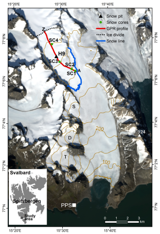
Figure 1. Location of the study area and location of radio-echo sounding (RES) in the accumulation zone (red line AZ), and snow pit H9 on the background of LandSat 8, August 2017. The snow line indicated is dated 26 August 2017. Capital letters stand for tributary glaciers: F—Fuglebreen, T—Tuvbreen, D—Deileggbreen, S—Staszelisen. The white square represents the Polish Polar Station (PPS). Contour line interval: 50 m. (geodata.npolar.no accessed on 22 December 2022).
Remotesensing 15 00189 g001
Figure 2. Snow cover layers distinguished on the GPR profiles. See the location of the GPR profiles on Figure 1.
Remotesensing 15 00189 g002
Figure 3. Distribution of GPR-derived snow depth (HS), density, and snow water equivalent (SWE) along the GPR_AZ profile. On each box, the central line indicates the median, and the bottom and top edges of the box indicate the 25th and 75th percentiles, respectively. The whiskers that extend to the most extreme data points are not considered outliers, and the outliers are plotted individually as dots. Mean HS, snow density, and SWE are represented by yellow diamonds and blue stars for the GPR_AZ profile and snow pit, respectively.
Remotesensing 15 00189 g003
Figure 4. Grain Shape. The white color refers to layers with undefined grain shape. Vertical rectangles in the middle of the GPR profiles denote HS and the grain shape in the snow pits (H9). See the location of the GPR profiles on Figure 1.
Remotesensing 15 00189 g004
Figure 5. Ice Formations and Melt Forms. Vertical bars on the GPR profiles denote Ice Formations and Melt Forms in the snow pits. See the location of the GPR profiles on Figure 1.
Remotesensing 15 00189 g005
Figure 6. Grain size. Vertical rectangles in the middle of the GPR profiles denote HS and the grain size in the snow pits (H9). The white spaces represent undefined grain size. See the location of the GPR profiles on Figure 1.
Remotesensing 15 00189 g006
Figure 7. Hardness index. Vertical rectangles in the middle of the GPR profiles denote HS and the hardness index in the snow pits (H9). The white spaces represent undefined hardness. See the location of the GPR profiles on Figure 1.
Remotesensing 15 00189 g007
Figure 8. Snow density and SWE. Pink lines show the elevation along with the GPR profile in 2008 (different profile course than in other seasons) and 2011 (representative for seasons 2011–2019). Vertical rectangles in the middle of the GPR profiles denote HS and density in the snow pits (H9). The white spaces represent undefined density. See the location of the GPR profiles on Figure 1.
Remotesensing 15 00189 g008
Figure 9. Percentage contribution of grain shape (a), size (b), hardness (c) and density (d) classes in 2008–2019. Bars marked H9 show the percentage of individual snow parameters in the snow pit. H9GPR bars represent the average value of individual parameters from 40 traces up and down from the location of the snow pit.
Remotesensing 15 00189 g009
Figure 10. HS and snow density measured in snow cores and derived from the nearest sections of GPR profile. Av. SC—average snow density in the snow core; AV. GPR—average snow density based on density of individual snow layers recognized in the section of GPR profile. Location of the GPR profile and snow cores (SC1, SC2, SC3, SC4) is presented on Figure 1.
Remotesensing 15 00189 g010
Figure 11. HLs recognized in snow cores, snow pit H9, and the nearest sections of GPR profile. A total of 1–4—HLs identified in the GPR profile; 1a–4a—HLs identified in snow cores corresponding to layers 1–4. Reference site H9 (HLs in the snow pit and corresponding GPR section is marked with a red dotted rectangle). Location of the GPR profile and snow cores (SC1, SC2, SC3, SC4) is presented on Figure 1.
Remotesensing 15 00189 g011
Figure 12. The number and thickness of Hard Layers (HL) (divided into Ice Formations and Melt Forms) vs. bulk density (ρs).
Remotesensing 15 00189 g012
Figure 13. HS v. SWE.
Remotesensing 15 00189 g013
Table 1. Details of GPR surveys and snow pit digging dates.
GPR DateSnow Pit—Closest Distance to the GPR Profile [m]Sampling Frequency [MHz]SamplesTime Interval [s]Time Window [ns]Snow Pit Date
26 April 2008-5116.65120.5100.0723, 24 April 2008
14 and 17 April 201115.112,791.610240.280.0516 April 2011
16 and 17 April 201338.812,791.610240.280.0511 May 2013
3 and 12 April 201420.912,791.610240.280.056 May 2014
2 April 201545149.25120.299.4329 April 2015
18 and 19 April 201813.4 *16,410.213240.280.6824 April 2018
6 April 20191.7512,763.510300.280.706 May 2019
* distance from stake H9.
Table 2. Snow cover properties in 2008–2019.
2008201120132014201520182019Average
Snow depth (HS) in H9 [m]4.064.173.152.7833.42.883.35
Average snow depth (HS) along GPR_AZ
(min-max) [m]
3.91 (3.17–4.85)3.68 (2.75–4.74)3.84 (2.33–4.97)3.16 (1.81–4.68)3.04 (1.83–4.02)2.88 (1.76–3.88)2.76 (1.63–3.55)3.32
Average accumulation rate (AR) along GPR_AZ [m 100 m−3]0.720.540.330.980.650.260.430.56
Number of layers in H9 (snow pit)4039262525252829.71
Number of layers in GPR_AZ (GPR profile)131113139111011.43
% of layers identified in GPR_AZ3328505236443639.86
Disclaimer/Publisher’s Note: The statements, opinions and data contained in all publications are solely those of the individual author(s) and contributor(s) and not of MDPI and/or the editor(s). MDPI and/or the editor(s) disclaim responsibility for any injury to people or property resulting from any ideas, methods, instructions or products referred to in the content.