Estimating Reservoir Storage Variations by Combining Sentinel-2 and 3 Measurements in the Yliki Reservoir, Greece


Abstract
1. Introduction
2. Materials and Methods
2.1. Study Area
In Situ Observations
2.2. Remote Sensing Data
2.3. Methodology
2.3.1. Extracting Reservoir’s Water Area from Sentinel-2 Images
2.3.2. Extracting Reservoir’s Water Level from Sentinel-3 Measurements
2.3.3. Combination of Sentinel-2 and Sentinel-3 Measurements
2.3.4. Estimating Reservoir’s Storage Variation from Satellite Data
2.3.5. Comparing Remotely Sensed Reservoir Characteristics with a Known L–A–S Relationship
3. Results
3.1. Sentinel-2 Time Series
3.1.1. Sentinel-2-Derived Water Area—Storage Relationship and Reservoir Water Cycle
3.2. Sentinel-3 Time Series
3.2.1. Sentinel-3-Derived Water Level–Storage Relationship and Reservoir Water Cycle
3.3. Combination of Sentinel-2 and Sentinel-3 Data
3.4. Estimating Water Storage Variation
3.5. Comparison with Existing L–A–S Curve
4. Discussion
5. Conclusions
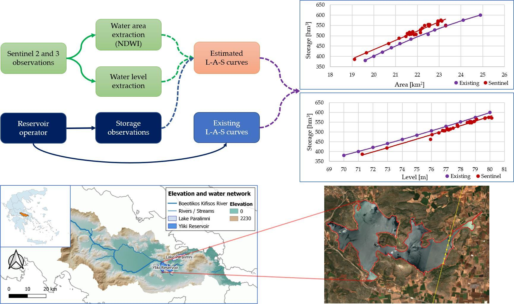
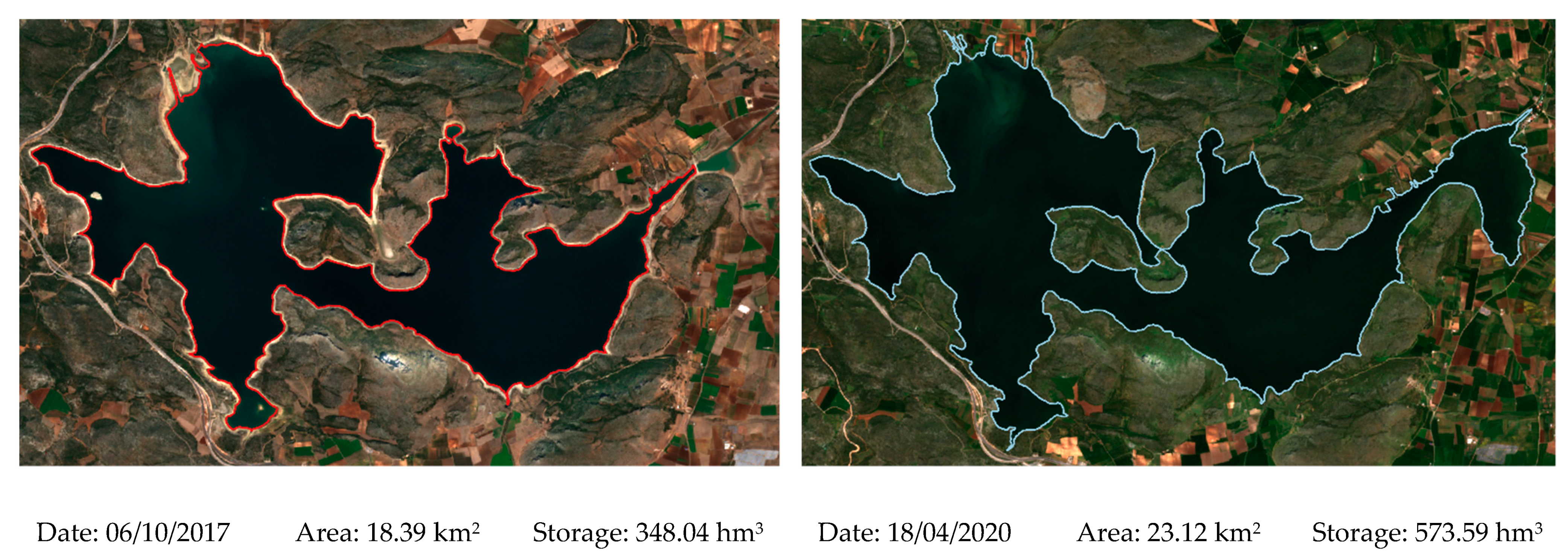
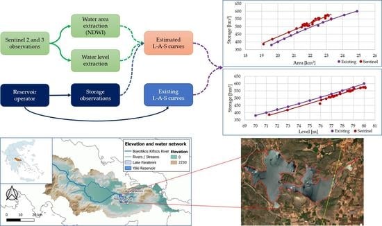
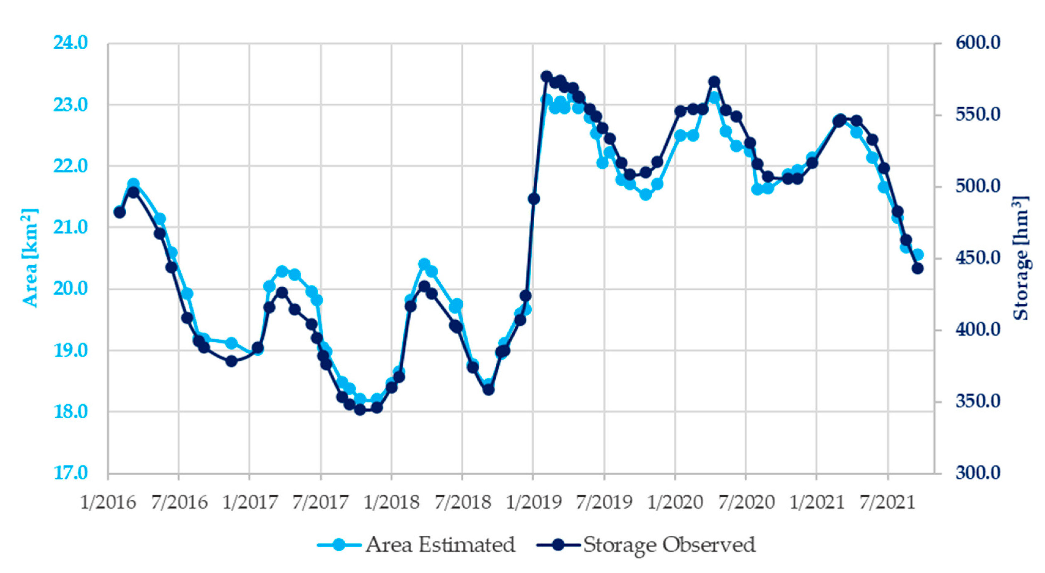
- Between March 2016 and September 2021, maximum and minimum water area observed were 23.14 km2 and 18.21 km2, respectively.
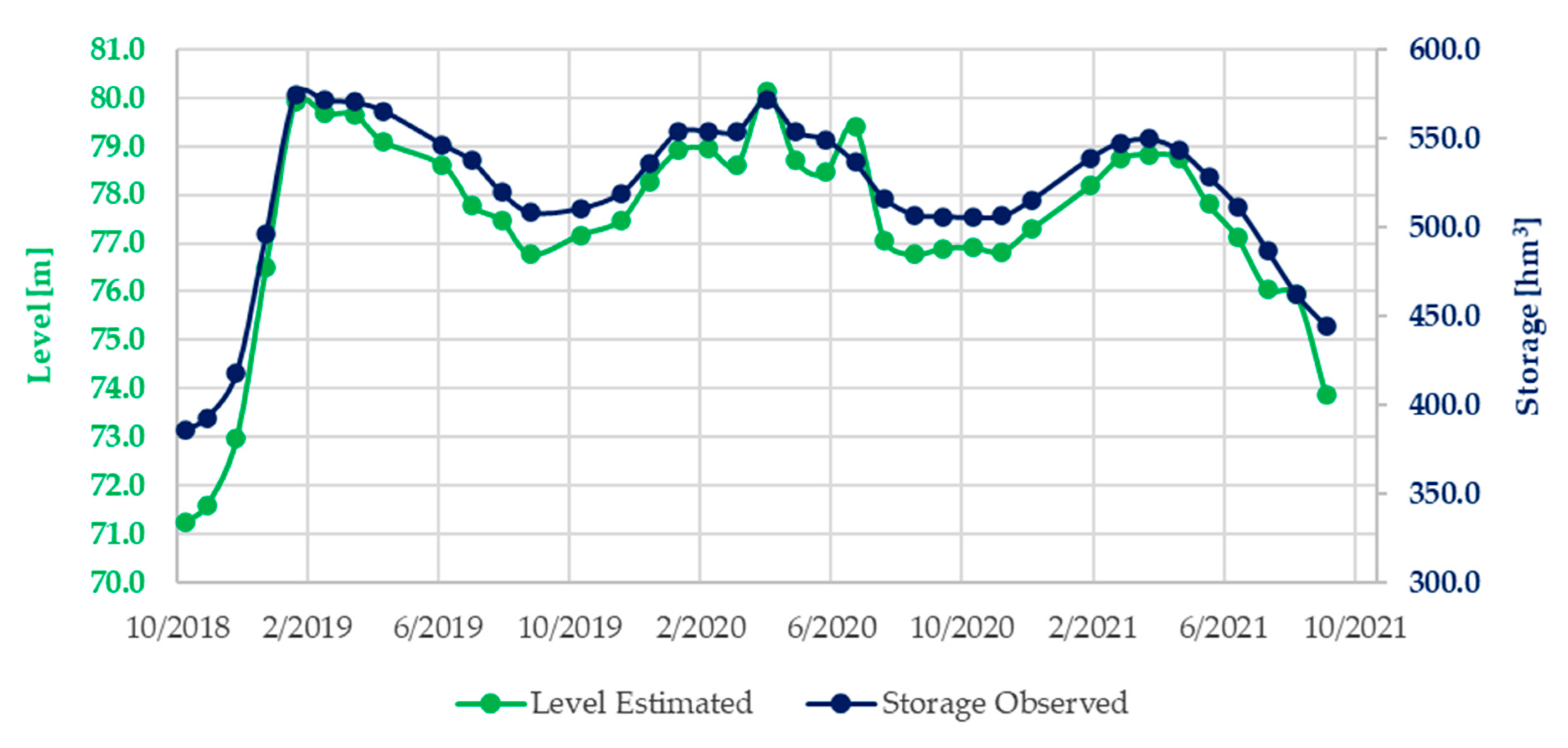
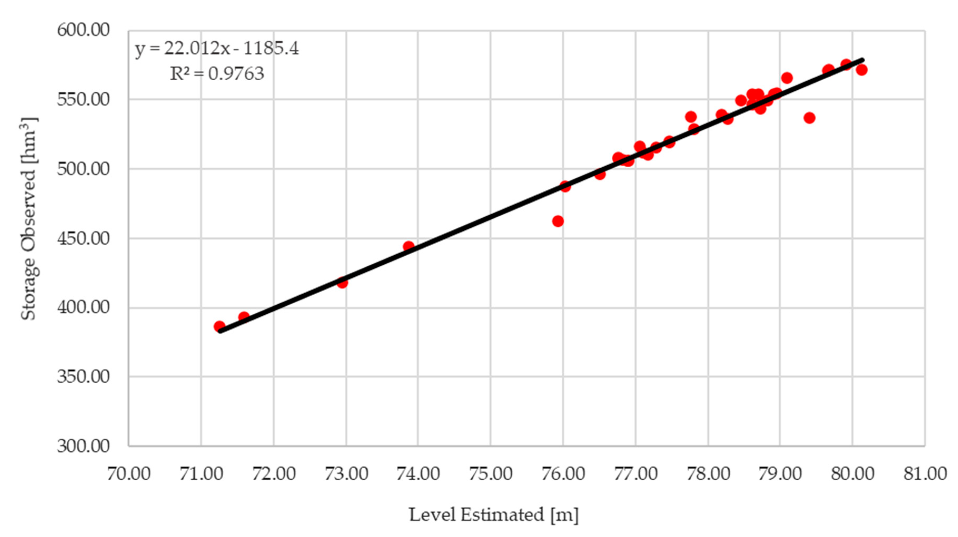
- Between November 2018 and September 2021, maximum and minimum water level observed were 80.1 m and 71.3 m, respectively.
- Water area short-term (monthly) maximum increase and decrease rates were calculated at 0.091 km2/d and 0.022 km2/d, respectively.
- Water level short-term (monthly) maximum increase and decrease rates were calculated at 0.132 m/d and 0.087 m/d, respectively.
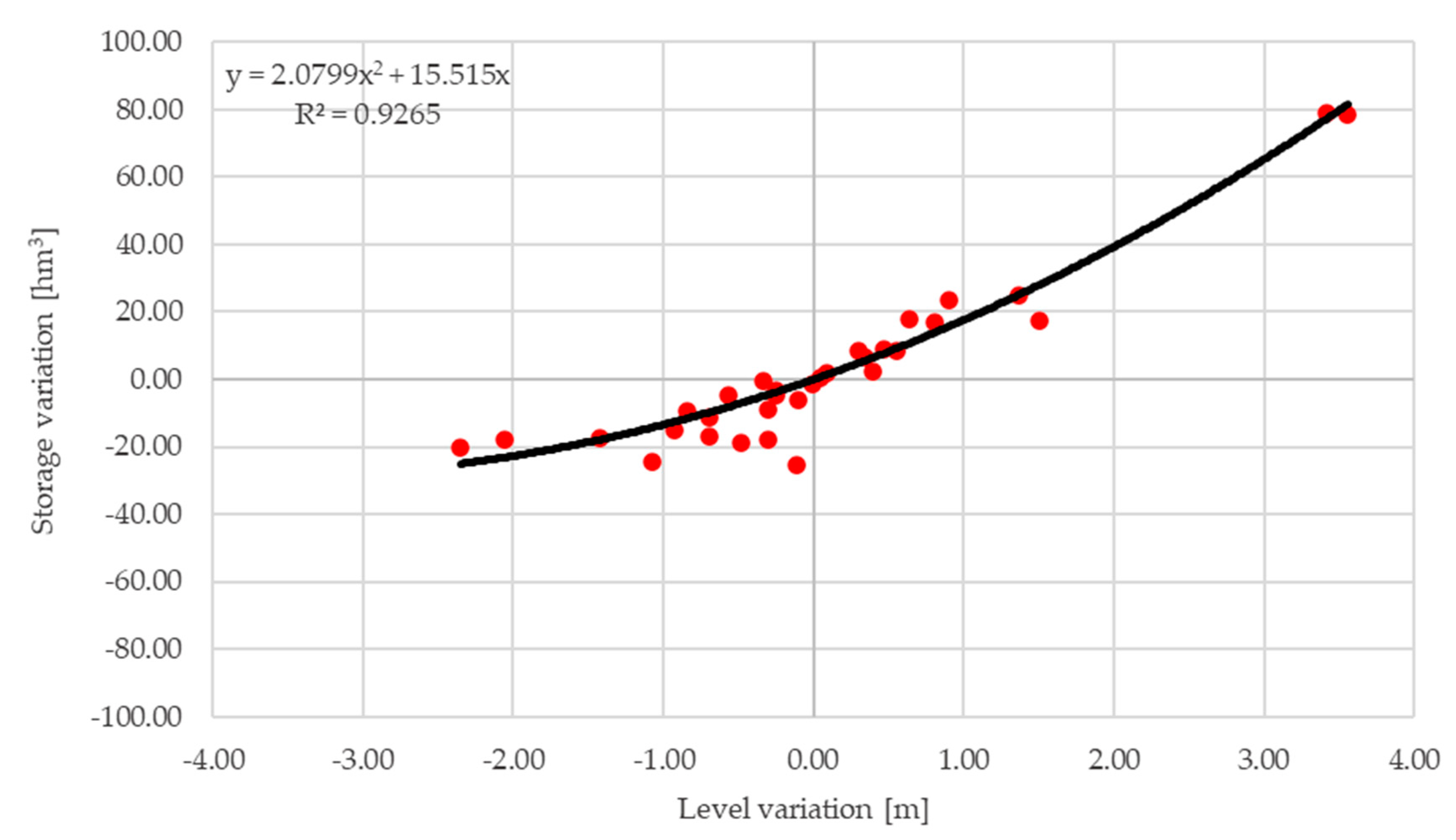
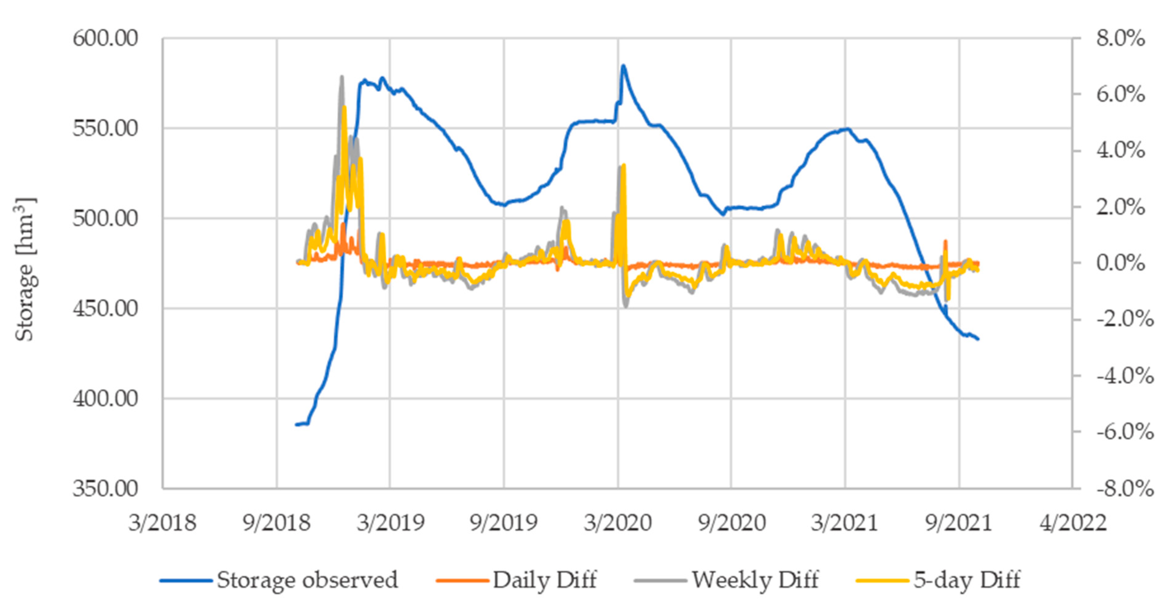
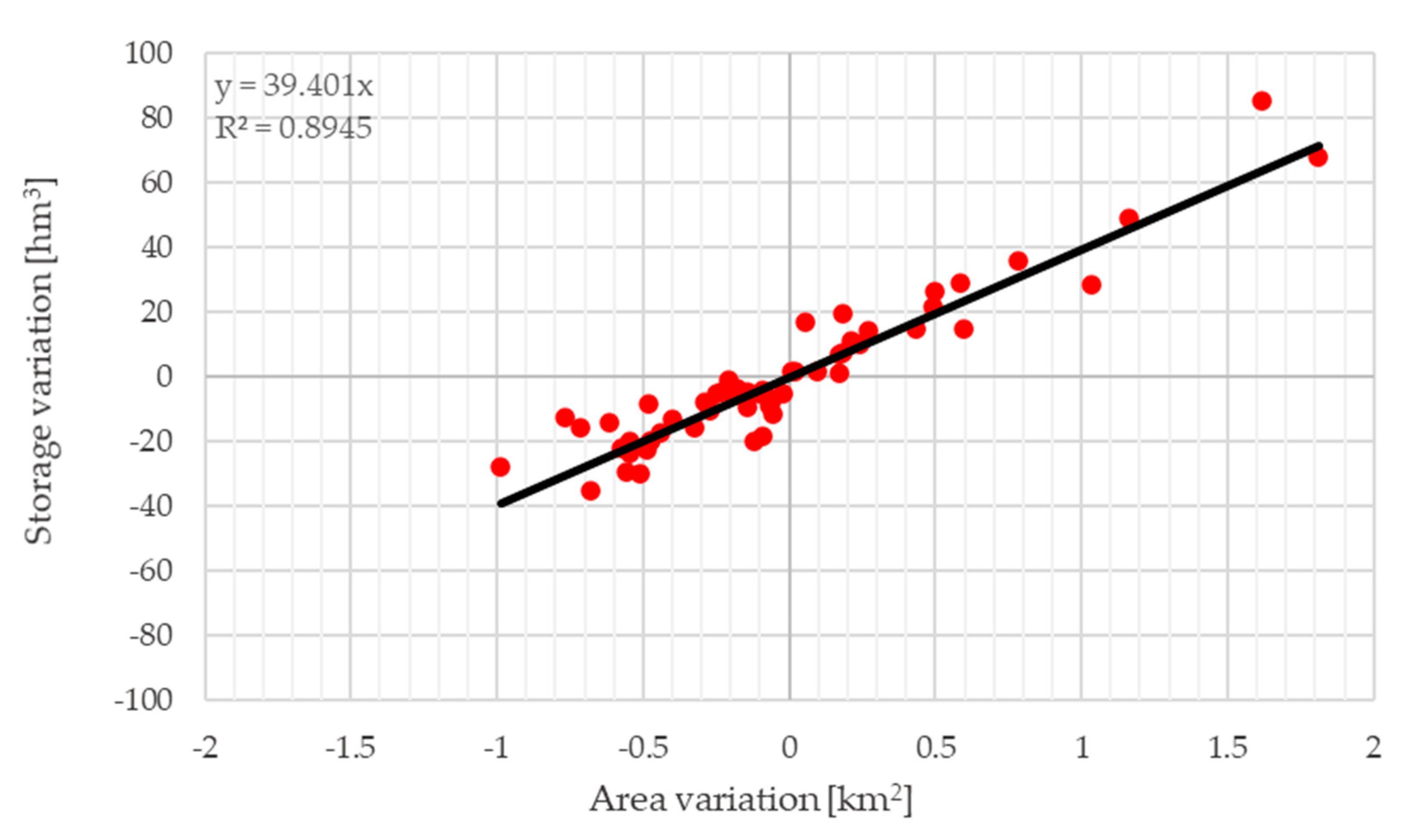
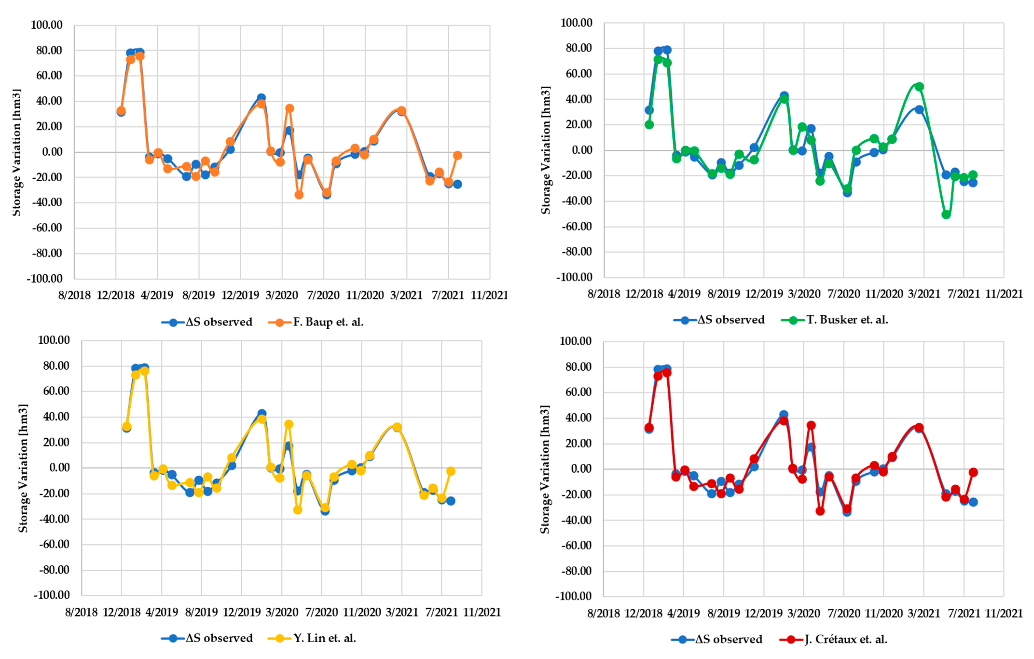
- The estimation of storage variation for the available data range, corresponding to 64–96% of the reservoir capacity, was successful. The RMSE was found to be 7.69 hm3 (1.28% of reservoir capacity), and the correlation coefficient was 96.14%.
Author Contributions
Funding
Institutional Review Board Statement
Informed Consent Statement
Data Availability Statement
Conflicts of Interest
References
- Williamson, C.E.; Saros, J.E.; Vincent, W.F.; Smol, J.P. Lakes and Reservoirs as Sentinels, Integrators, and Regulators of Climate Change. Limnol. Oceanogr. 2009, 54, 2273–2282. [Google Scholar] [CrossRef] [Scilit]
- Busker, T.; de Roo, A.; Gelati, E.; Schwatke, C.; Adamovic, M.; Bisselink, B.; Pekel, J.-F.; Cottam, A. A Global Lake and Reservoir Volume Analysis Using a Surface Water Dataset and Satellite Altimetry. Hydrol. Earth Syst. Sci. Discuss. 2019, 23, 669–690. [Google Scholar] [CrossRef] [Scilit]
- Frappart, F.; Zeiger, P.; Betbeder, J.; Gond, V.; Bellot, R.; Baghdadi, N.; Blarel, F.; Darrozes, J.; Bourrel, L.; Seyler, F. Automatic Detec-Tion of Inland Water Bodies along Altimetry Tracks for Estimating Surface Water Storage Variations in the Congo Basin. Remote Sens. 2021, 10, 3804. [Google Scholar] [CrossRef] [Scilit]
- Kostianoy, A.G.; Lebedev, S.A.; Kostianaia, E.A.; Prokofiev, Y.A. Interannual Variability of Water Level in Two Largest Lakes of Europe. Remote Sens. 2022, 14, 659. [Google Scholar] [CrossRef] [Scilit]
- Gourgouletis, N.; Bariamis, G.; Baltas, E. Estimation of Characteristics of Surface Water Bodies Based on Sentinel-2 Images: The Case Study of Yliki Reservoir. In Proceedings of the Eighth International Conference on Environmental Management, Engineering, Planning & Economics, Thessaloniki, Greece, 20–24 July 2021; pp. 551–558. [Google Scholar]
- Schmitz, O.J.; Raymond, P.A.; Estes, J.A.; Kurz, W.A.; Holtgrieve, G.W.; Ritchie, M.E.; Schindler, D.E.; Spivak, A.C.; Wilson, R.W.; Bradford, M.A.; et al. Animating the Carbon Cycle. Ecosystems 2014, 17, 344–359. [Google Scholar] [CrossRef] [Scilit]
- Jimenez Cisneros, B.E.; Oki, T.; Arnell, N.W.; Benito, G.; Cogley, J.G.; Döll, P.; Jiang, T.; Mwakalila, S.S. Freshwater Resources. In Climate Change 2014: Impacts, Adaptation, and Vulnerability. Part A: Global and Sectoral Aspects. Contribution of Working Group II to the Fifth Assessment Report of the Intergovernmental Panel on Climate Change; Field, C.B., Barros, V.R., Dokken, D.J., Mach, K.J., Mastrandrea, M.D., Bilir, T.E., Chatterjee, M., Ebi, K.L., Estrada, Y.O., Genova, R.C., et al., Eds.; Cambridge University Press: Cambridge, UK; New York, NY, USA, 2014; pp. 1199–1265. [Google Scholar]
- Kovats, R.S.; Valentini, R.M.; Bouwer, L.; Georgopoulou, E.; Jacob, D.; Martin, E.; Rounsevell, M.; Soussana, J.-F. Europe. In Climate Change 2014: Impacts, Adaptation, and Vulnerability. Part B: Regional Aspects. Contribution of Working Group II to the Fifth Assessment Report of the Intergovernmental Panel on Climate Change; Field, C.B., Barros, V.R., Dokken, D.J., Mach, K.J., Mastrandrea, M.D., Bilir, T.E., Chatterjee, M., Ebi, K.L., Estrada, Y.O., Genova, R.C., et al., Eds.; Cambridge University Press: Cambridge, UK; New York, NY, USA, 2014; pp. 1267–1326. [Google Scholar]
- Weatherhead, E.K.; Howden, N.J.K. The Relationship between Land Use and Surface Water Resources in the UK. Land Use Policy 2009, 26, S243–S250. [Google Scholar] [CrossRef] [Scilit]
- Thornton, P.K.; Herrero, M. The Inter-Linkages between Rapid Growth in Livestock Production, Climate Change, and the Impacts on Water Resources, Land Use, and Deforestation Background Paper to the 2010 World Development Report. 2010. Available online: http://hdl.handle.net/10986/9223 (accessed on 14 December 2021).
- Bariamis, G.; Paschos, G.; Baltas, E. Land Accounts in the River Basin Districts of Greece. Environ. Process. 2018, 5, 213–237. [Google Scholar] [CrossRef] [Scilit]
- Water and Climate Change Adaptation; OECD Studies on Water; OECD: Paris, France, 2013; ISBN 9789264200432.
- Karavitis, C.A.; Chortaria, C.; Alexandris, S.; Vasilakou, C.G.; Tsesmelis, D.E. Development of the Standardised Precipitation Index for Greece. Urban Water J. 2012, 9, 401–417. [Google Scholar] [CrossRef] [Scilit]
- Livada, I.; Assimakopoulos, V.D. Spatial and Temporal Analysis of Drought in Greece Using the Standardized Precipitation Index (SPI). Theor. Appl. Climatol. 2007, 89, 143–153. [Google Scholar] [CrossRef] [Scilit]
- Terzidis, G. Water Scarcity; Causes, Forecasting Potential and Mitigation Measures in the Urban and Agricultural Development of Greece. In Proceedings of the Water Scarcity and Floods, Geotechnical Chamber of Greece, Thessaloniki, Greece, 17 March 1992; pp. 25–40. [Google Scholar]
- Biswas, A.K. Integrated Water Resources Management: A Reassessment. Water Int. 2004, 29, 248–256. [Google Scholar] [CrossRef] [Scilit]
- Schwatke, C.; Dettmering, D.; Bosch, W.; Seitz, F. DAHITI—An Innovative Approach for Estimating Water Level Time Series over Inland Waters Using Multi-Mission Satellite Altimetry. Hydrol. Earth Syst. Sci. 2015, 19, 4345–4364. [Google Scholar] [CrossRef] [Scilit]
- Baup, F.; Frappart, F.; Maubant, J. Combining High-Resolution Satellite Images and Altimetry to Estimate the Volume of Small Lakes. Hydrol. Earth Syst. Sci. 2014, 18, 2007–2020. [Google Scholar] [CrossRef] [Scilit]
- Zhang, C.; Lv, A.; Zhu, W.; Yao, G.; Qi, S. Using Multisource Satellite Data to Investigate Lake Area, Water Level, and Water Storage Changes of Terminal Lakes in Ungauged Regions. Remote Sens. 2021, 13, 3221. [Google Scholar] [CrossRef] [Scilit]
- Lin, Y.; Li, X.; Zhang, T.; Chao, N.; Yu, J.; Cai, J.; Sneeuw, N. Water Volume Variations Estimation and Analysis Using Multisource Satellite Data: A Case Study of Lake Victoria. Remote Sens. 2020, 12, 3052. [Google Scholar] [CrossRef] [Scilit]
- Du, Y.; Zhang, Y.; Ling, F.; Wang, Q.; Li, W.; Li, X. Water Bodies’ Mapping from Sentinel-2 Imagery with Modified Normalized Difference Water Index at 10-m Spatial Resolution Produced by Sharpening the Swir Band. Remote Sens. 2016, 8, 354. [Google Scholar] [CrossRef] [Scilit]
- Schmitt, M. Potential of Large-Scale Inland Water Body Mapping from Sentinel-1/2 Data on the Example of Bavaria’s Lakes and Rivers. PFG—J. Photogramm. Remote Sens. Geoinf. Sci. 2020, 88, 271–289. [Google Scholar] [CrossRef] [Scilit]
- Carabajal, C.C.; Boy, J.P. Lake and Reservoir Volume Variations in South America from Radar Altimetry, ICESat Laser Altimetry, and GRACE Time-Variable Gravity. Adv. Space Res. 2021, 68, 652–671. [Google Scholar] [CrossRef] [Scilit]
- Duan, Z.; Bastiaanssen, W.G.M. Estimating Water Volume Variations in Lakes and Reservoirs from Four Operational Satellite Altimetry Databases and Satellite Imagery Data. Remote Sens. Environ. 2013, 134, 403–416. [Google Scholar] [CrossRef] [Scilit]
- Song, C.; Huang, B.; Ke, L. Inter-Annual Changes of Alpine Inland Lake Water Storage on the Tibetan Plateau: Detection and Analysis by Integrating Satellite Altimetry and Optical Imagery. Hydrol. Processes 2014, 28, 2411–2418. [Google Scholar] [CrossRef] [Scilit]
- Kittel, C.M.M.; Jiang, L.; Tøttrup, C.; Bauer-Gottwein, P. Sentinel-3 Radar Altimetry for River Monitoring—A Catchment-Scale Evaluation of Satellite Water Surface Elevation from Sentinel-3A and Sentinel-3B. Hydrol. Earth Syst. Sci. 2021, 25, 333–357. [Google Scholar] [CrossRef] [Scilit]
- Arsen, A.; Crétaux, J.F.; Berge-Nguyen, M.; del Rio, R.A. Remote Sensing-Derived Bathymetry of Lake Poopó. Remote Sens. 2013, 6, 407–420. [Google Scholar] [CrossRef] [Scilit]
- Elsahabi, M.; Makboul, O.; Negm, A.M. Lake Nubia Bathymetry Detection by Satellite Remote Sensing. Int. Water Technol. J. IWTJ 2018, 8, 9–17. [Google Scholar]
- Forfinski-Sarkozi, N.A.; Parrish, C.E. Analysis of MABEL Bathymetry in Keweenaw Bay and Implications for ICESat-2 ATLAS. Remote Sens. 2016, 8, 772. [Google Scholar] [CrossRef] [Scilit]
- Getirana, A.; Jung, H.C.; Tseng, K.H. Deriving Three Dimensional Reservoir Bathymetry from Multi-Satellite Datasets. Remote Sens. Environ. 2018, 217, 366–374. [Google Scholar] [CrossRef] [Scilit]
- Markogianni, V.; Kalivas, D.; Petropoulos, G.P.; Dimitriou, E. Modelling of Greek Lakes Water Quality Using Earth Observation in the Framework of the Water Framework Directive (WFD). Remote Sens. 2022, 14, 739. [Google Scholar] [CrossRef] [Scilit]
- Peppa, M.; Vasilakos, C.; Kavroudakis, D. Eutrophication Monitoring for Lake Pamvotis, Greece, Using Sentinel-2 Data. ISPRS Int. J. Geo-Inf. 2020, 9, 143. [Google Scholar] [CrossRef] [Scilit]
- Alexandridis, T.K.; Takavakoglou, V.; Crisman, T.L.; Zalidis, G.C. Remote Sensing and GIS Techniques for Selecting a Sustainable Scenario for Lake Koronia, Greece. Environ. Manag. 2007, 39, 278–290. [Google Scholar] [CrossRef] [Scilit]
- Papastergiadou, E.S.; Retalis, A.; Apostolakis, A.; Georgiadis, T. Environmental Monitoring of Spatio-Temporal Changes Using Remote Sensing and GIS in a Mediterranean Wetland of Northern Greece. Water Resour. Manag. 2008, 22, 579–594. [Google Scholar] [CrossRef] [Scilit]
- Psomiadis, E.; Soulis, K.X.; Zoka, M.; Dercas, N. Synergistic Approach of Remote Sensing and Gis Techniques for Flash-Flood Monitoring and Damage Assessment in Thessaly Plain Area, Greece. Water 2019, 11, 448. [Google Scholar] [CrossRef] [Scilit]
- Capolongo, D.; Refice, A.; Bocchiola, D.; D’Addabbo, A.; Vouvalidis, K.; Soncini, A.; Zingaro, M.; Bovenga, F.; Stamatopoulos, L. Coupling Multitemporal Remote Sensing with Geomorphology and Hydrological Modeling for Post Flood Recovery in the Strymonas Dammed River Basin (Greece). Sci. Total Environ. 2019, 651, 1958–1968. [Google Scholar] [CrossRef] [Scilit]
- Kontopoulou, E.; Kolokoussis, P.; Karantzalos, K. Water Quality Estimation in Greek Lakes from Landsat 8 Multispectral Satellite Data. Eur. Water 2017, 58, 191–196. [Google Scholar]
- Elhag, M.; Yilmaz, N. Insights of Remote Sensing Data to Surmount Rainfall/Runoff Data Limitations of the Downstream Catchment of Pineios River, Greece. Environ. Earth Sci. 2021, 80, 35. [Google Scholar] [CrossRef] [Scilit]
- Special Secreteriat for Water. 1st Revision of the Management Plan of the River Basin District of Eastern Central Greece. Athens. 2017. Available online: http://wfdver.ypeka.gr/el/management-plans-gr/1revision-approved-management-plans-gr/approved-1revision-el07-gr/ (accessed on 6 January 2022).
- EYDAP. Water Supply Resources. Available online: https://www.eydap.gr/en/TheCompany/Water/WaterSources/ (accessed on 6 January 2022).
- Special Secreteriat for Water. Strategic Environmental Impact Assessment of the 1st Revision of the River Basin District Management Plan of Eastern Central Greece (EL07). Athens. 2017. Available online: http://wfdver.ypeka.gr/el/project/consultation-el07-18-1revision-smpe-gr/ (accessed on 6 January 2022).
- Efstratiadis, A.; Tsoukalas, I. Revision of the Yliki and Paralimni Water Balance and Evaluation of the Overflow Risk during Current Hydrologic Year. Athens. 2019. Available online: http://www.itia.ntua.gr/el/docinfo/2014/ (accessed on 14 December 2021).
- EYDAP. Raw Water Reserves. Available online: https://www.eydap.gr/en/TheCompany/Water/Savings/ (accessed on 14 December 2021).
- SUHET. SENTINEL-2 User Handbook. 2015. Available online: https://sentinels.copernicus.eu/web/sentinel/user-guides/document-library/-/asset_publisher/xlslt4309D5h/content/sentinel-2-user-handbook (accessed on 21 October 2021).
- European Space Agency. Sentinel-3 Altimetry Technical Guide. Available online: https://sentinel.esa.int/web/sentinel/technical-guides/sentinel-3-altimetry/ (accessed on 21 October 2021).
- European Space Agency. Sentinel-3 Atlimetry Overview. Available online: https://sentinel.esa.int/web/sentinel/user-guides/sentinel-3-altimetry/overview (accessed on 10 October 2021).
- EUMETSAT. Past Processing Baselines. Available online: https://www.eumetsat.int/past-processing-baselines (accessed on 23 October 2021).
- European Space Agency; French Space Agency. Radar Altimetry Tutorial & Toolbox. Available online: http://www.altimetry.info/radar-altimetry-tutorial/data-flow/data-processing/retracking/ (accessed on 27 October 2021).
- Yang, X.; Zhao, S.; Qin, X.; Zhao, N.; Liang, L. Mapping of Urban Surface Water Bodies from Sentinel-2 MSI Imagery at 10 m Resolution via NDWI-Based Image Sharpening. Remote Sens. 2017, 9, 596. [Google Scholar] [CrossRef] [Scilit]
- Cavallo, C.; Papa, M.N.; Gargiulo, M.; Palau-Salvador, G.; Vezza, P.; Ruello, G. Continuous Monitoring of the Flooding Dynamics in the Albufera Wetland (Spain) by Landsat-8 and Sentinel-2 Datasets. Remote Sens. 2021, 13, 3525. [Google Scholar] [CrossRef] [Scilit]
- McFeeters, S.K. The Use of the Normalized Difference Water Index (NDWI) in the Delineation of Open Water Features. Int. J. Remote Sens. 1996, 17, 1425–1432. [Google Scholar] [CrossRef] [Scilit]
- Sekertekin, A. A Survey on Global Thresholding Methods for Mapping Open Water Body Using Sentinel-2 Satellite Imagery and Normalized Difference Water Index. Arch. Comput. Methods Eng. 2021, 28, 1335–1347. [Google Scholar] [CrossRef] [Scilit]
- Prewitt, J.M.S.; Mendelsohn, M.L. The Analysis of Cell Images. Ann. N. Y. Acad. Sci. 2006, 128, 1035–1053. [Google Scholar] [CrossRef] [Scilit]
- Crétaux, J.F.; Bergé-Nguyen, M.; Calmant, S.; Jamangulova, N.; Satylkanov, R.; Lyard, F.; Perosanz, F.; Verron, J.; Montazem, A.S.; Le Guilcher, G.; et al. Absolute Calibration or Validation of the Altimeters on the Sentinel-3A and the Jason-3 over Lake Issykkul (Kyrgyzstan). Remote Sens. 2018, 10, 1679. [Google Scholar] [CrossRef] [Scilit]
- Crétaux, J.F.; Abarca-del-Río, R.; Bergé-Nguyen, M.; Arsen, A.; Drolon, V.; Clos, G.; Maisongrande, P. Lake Volume Monitoring from Space. Surv. Geophys. 2016, 37, 269–305. [Google Scholar] [CrossRef] [Scilit]
- Vignudelli, S.; Scozzari, A.; Abileah, R.; Scozzari, A. A Completely Remote Sensing Approach To Monitoring Reservoirs Water Volume. Int. Water Technol. J. 2011, 1, 63–77. [Google Scholar]





Publisher’s Note: MDPI stays neutral with regard to jurisdictional claims in published maps and institutional affiliations. |
© 2022 by the authors. Licensee MDPI, Basel, Switzerland. This article is an open access article distributed under the terms and conditions of the Creative Commons Attribution (CC BY) license (https://creativecommons.org/licenses/by/4.0/).
Share and Cite
Gourgouletis, N.; Bariamis, G.; Anagnostou, M.N.; Baltas, E. Estimating Reservoir Storage Variations by Combining Sentinel-2 and 3 Measurements in the Yliki Reservoir, Greece. Remote Sens. 2022, 14, 1860. https://doi.org/10.3390/rs14081860
Gourgouletis N, Bariamis G, Anagnostou MN, Baltas E. Estimating Reservoir Storage Variations by Combining Sentinel-2 and 3 Measurements in the Yliki Reservoir, Greece. Remote Sensing. 2022; 14(8):1860. https://doi.org/10.3390/rs14081860
Chicago/Turabian StyleGourgouletis, Nikolaos, Georgios Bariamis, Marios N. Anagnostou, and Evangelos Baltas. 2022. "Estimating Reservoir Storage Variations by Combining Sentinel-2 and 3 Measurements in the Yliki Reservoir, Greece" Remote Sensing 14, no. 8: 1860. https://doi.org/10.3390/rs14081860
APA StyleGourgouletis, N., Bariamis, G., Anagnostou, M. N., & Baltas, E. (2022). Estimating Reservoir Storage Variations by Combining Sentinel-2 and 3 Measurements in the Yliki Reservoir, Greece. Remote Sensing, 14(8), 1860. https://doi.org/10.3390/rs14081860