Article

Long-Term Changes and Factors That Influence Changes in Thermal Discharge from Nuclear Power Plants in Daya Bay, China

1
School of Marine Technology and Geomatics, Jiangsu Ocean University, Lianyungang 222005, China
2
State Key Laboratory of Satellite Ocean Environment Dynamics, Second Institute of Oceanography, Ministry of Natural Resources of the People’s Republic of China, Hangzhou 310012, China
3
Southern Marine Science and Engineering Guangdong Laboratory (Guangzhou), Guangzhou 511400, China
*
Author to whom correspondence should be addressed.
Remote Sens. 2022, 14(3), 763; https://doi.org/10.3390/rs14030763
Submission received: 3 January 2022 / Revised: 29 January 2022 / Accepted: 1 February 2022 / Published: 7 February 2022
(This article belongs to the Special Issue Remote Sensing Applications in Ocean Observation)

Abstract

:
Thermal discharge (i.e., warm water) from nuclear power plants (NPPs) in Daya Bay, China, was analyzed in this study. To determine temporal and spatial patterns as well as factors affecting thermal discharge, data were acquired by the Landsat series of remote-sensing satellites for the period 1993–2020. First, sea surface temperature (SST) data for waters off NPPs were retrieved from Landsat imagery using a radiative transfer equation in conjunction with a split-window algorithm. Then, retrieved SST data were used to analyze seasonal and interannual changes in areas affected by NPP thermal discharge, as well as the effects of NPP installed capacity, tides, and wind field on the diffusion of thermal discharge. Analysis of interannual changes revealed an increase in SST with an increase in NPP installed capacity, with the area affected by increased drainage outlet temperature increasing to different degrees. Sea surface temperature and NPP installed capacity were significantly linearly related. Both flood tides (peak spring and neap) and ebb tides (peak spring and neap) affected areas of warming zones, with ebb tides having greater effects. The total area of all warming zones in summer was approximately twice that in spring, regardless of whether winds were favorable (i.e., westerly) or adverse (i.e., easterly). The effects of tides on areas of warming zones exceeded those of winds.

1. Introduction

In recent years, the increasing energy demand of coastal cities has increased both the number and scale of coastal thermal power plants and NPPs. In NPPs, only 30% to 35% of nuclear energy is converted to electrical energy [1], and most of the remaining energy is discharged as thermal energy in cooling water. The discharge of warm water rapidly increases the temperature of surrounding waters, which in turn directly or indirectly affects the growth and reproduction of aquatic organisms [2].
To monitor thermal discharge, many studies have examined algorithms to retrieve sea surface temperatures (SSTs) from thermal infrared remote sensing. In 1975, McMillin [3] first introduced a split-window algorithm (SWA) based on the radiative transfer equation (RTE), which was relatively effective at retrieving SST [4]. Liu and Zhou [5] introduced a multichannel SWA to retrieve SST data for the Yellow and East China seas, and the retrieved data adequately reflected SST distribution patterns. Rozenstein et al. [6] and Chen et al. [7] revised the SWA to use data acquired by the Advanced Very-High-Resolution Radiometer instruments onboard the United States National Oceanic and Atmospheric Administration (NOAA) family of satellites in order to retrieve SSTs from Landsat satellite data. Ai et al. [8] presented a new SWA-based SST retrieval model and validated its reliability by comparing SST data for the Bohai Sea with those extracted from a MODIS SST product.
Furthermore, clarifying the influencing factors of the warm drainage of nuclear power plants is of great significance for predicting its changing trend and evaluating and finding ways to speed up the hydrodynamic exchange of warm drainage to minimize its ecological impact. The velocity and direction of tide, wind, water depth, and installed capacity are considered to be the main factors affecting thermal discharge [9,10,11,12]. Hence, it is crucial to investigate factors and mechanisms that influence changes in thermal discharge from NPPs.
Many studies have recently examined the effects of NPPs on Daya Bay in China. For example, nutrients, phytoplankton, and zooplankton in Daya Bay show marked responses to thermal discharge from NPPs [13]. However, changes in Daya Bay based on time-series data covering more than two decades have not been investigated. High-accuracy remote-sensing time-series data can be used to monitor the zones affected by thermal discharge, as well as to identify patterns of change in and factors influencing thermal discharge. Hence, in this study, data reflecting changes in thermal discharge in waters surrounding NPPs in Daya Bay from 1993 to 2020 were retrieved from remote sensing imagery, acquired by Landsat satellites. Those data were then used to analyze the seasonal and interannual temporal and spatial distribution patterns of thermal discharge. In addition, the effects of tides and the wind field on diffusion of thermal discharge were examined. The results will provide an important reference for protection of the ecology and environments in waters off coastal NPPs.

2. Data

2.1. Study Area

In the northern part of the South China Sea, Daya Bay (23°31′12″ N to 24°50′00″ N, 113°29′42″ E to 114°49′42″ E) encompasses ~600 km2 [14,15] and includes more than 50 islands (Figure 1). The bay is very shallow, with an average depth of 11 m and a maximum depth of 21 m, and its waters are cold with high salinity in winter and hot with low salinity in summer [16]. A monsoon and oceanic climate prevails, with four distinct seasons and an annual average temperature of ~22 °C. Wind over Daya Bay is dominated by northeasterlies in winter and southwesterlies in summer, with relatively high speeds (monthly average: 5.0–5.4 m/s) in spring and early summer and relatively low speeds (monthly average: 4.6–4.8 m/s) in the remainder of summer and winter [17]. The Daya Bay NPP (DBNPP), with an installed capacity of 1968 MW, and the Lingao NPP (LNPP), with an installed capacity of 4152 MW, began operating in 1994 and 2002, respectively.

2.2. Landsat Data

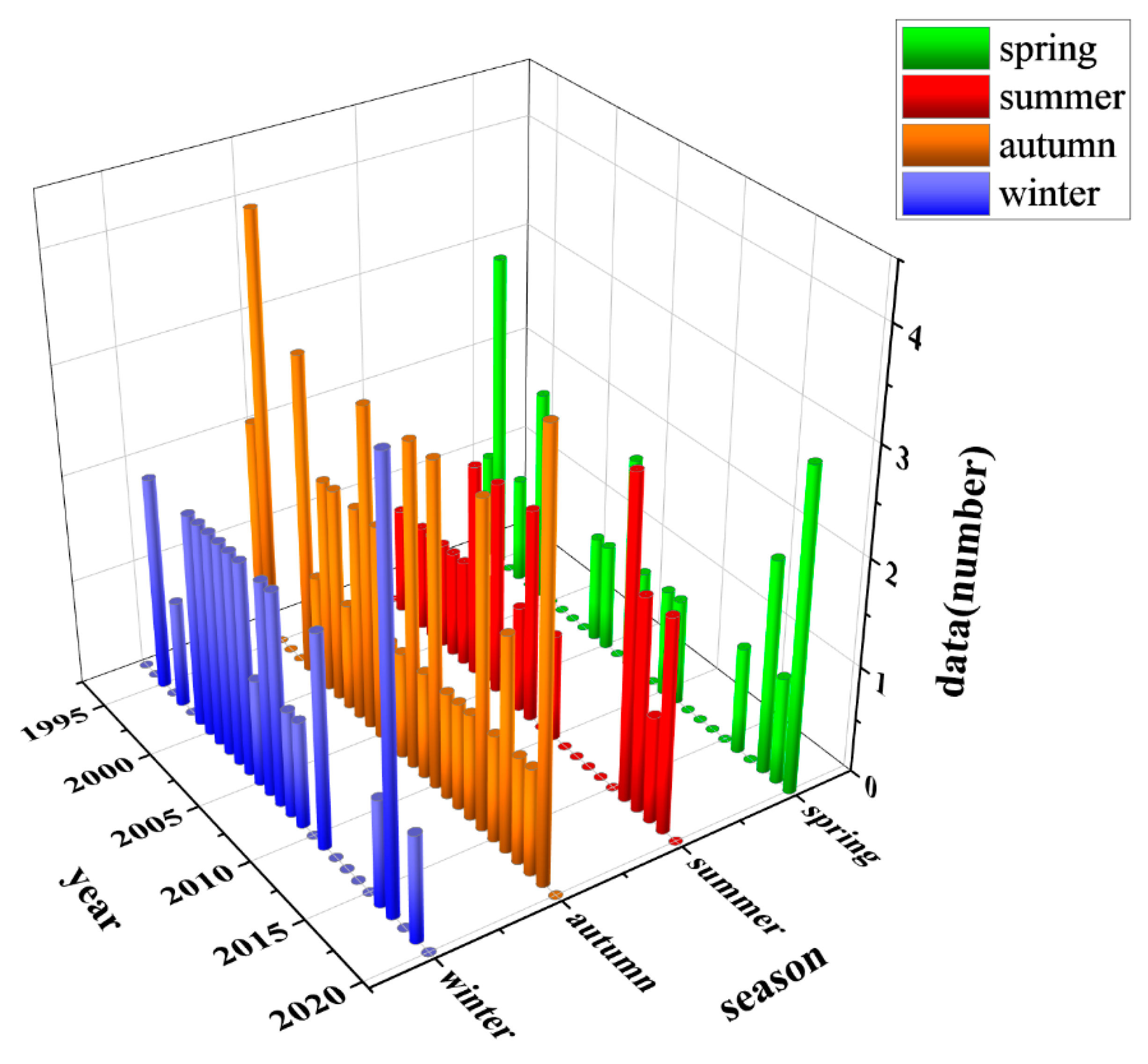
Landsat Level-1 imagery (spatial resolution: 30 m) was acquired for the period 1993 to 2020. Specifically, 125 good-quality Landsat-5, -7, and -8 images, each with cloud coverage less than 20%, were downloaded from the website of the United States Geological Survey (https://earthexplorer.usgs.gov/, accessed on 2 January 2022). Each image was acquired at approximately 0245 Greenwich Mean Time (GMT) when the satellite flew over Daya Bay. The temperature data contained in those images spanned almost the entire range of temperatures over the period, from low temperatures in winter to high temperatures in summer, and therefore were representative of seasons in the area. Figure 2 shows the amount of Landsat images in each season.

2.3. MODIS Data

MODIS is an important sensor onboard the Terra and Aqua satellites. Each day, the Terra satellite flies over the study area at approximately 1030 and 2230 GMT, whereas the Aqua satellite flies over at approximately 0130 and 1330 GMT. A MODIS Level-2 SST product that provides data with 1-km resolution and long-term quality control was obtained from the official website of the United States National Aeronautics and Space Administration (NASA, http://oceancolor.gsfc.nasa.gov/, accessed on 2 January 2022).

2.4. Tidal Data and Processing

Daily tidal level data were collected at a Daya Bay meteorological station (22°35′ N, 114°31′ E) from 1993 to 2020. A tide table was produced based on the tidal height at each time point to determine the tidal state of waters when the satellites flew over the study area. In addition, average areas of warming zones with different levels of increase in SST in each tidal state were compared in order to analyze the effects of tides on the diffusion of thermal discharge.

2.5. Wind Field Data and Processing

To analyze the effects of the wind field on diffusion of thermal discharge, average direction and speed data were determined for the wind field over a zone approximately 15 km offshore (22°45′N to 23°12′N, 114°36′E to 115°00′E). Those data were extracted from a Cross-Calibrated Multi-Platform Level-3 product (www.remss.com/measurements/ccmp, accessed on 2 January 2022) that provided ocean surface wind data (i.e., data for wind fields 10 m above the ocean surface) with a spatial resolution of 0.25° × 0.25°. Westerlies (including southwesterlies and northwesterlies), which promote diffusion of thermal discharge, were defined as favorable winds, whereas easterlies (including northeasterlies and southeasterlies), which limit diffusion of thermal discharge, were defined as adverse winds.

2.6. Installed Capacity Data for Nuclear Power Plants in the Study Area

Installed capacity data for the NPPs in Daya Bay (Table 1) were extracted from their introductions given by the South China Nuclear and Radiation Oversight Station, Ministry of Ecology and Environment of China (https://scro.mee.gov.cn, accessed on 2 January 2022).

3. Methods

3.1. Data Preprocessing

Landsat imagery was subjected to preprocessing procedures such as radiometric calibration and conversion of gray values to radiance values with a physical meaning [18], i.e., top-of-atmosphere radiance, L(λ), values, which are input data for temperature inversion. L(λ) was calculated using the following equation:
L ( λ ) = D N × G a i n + h
where DN is the original value recorded by the sensor, Gain is the absolute calibration coefficient, and h is the offset. Gain and h were obtained directly from the parameter file of Landsat data [19].

3.2. Sea Surface Temperature Retrieval

Sea surface temperatures were retrieved from Landsat-5 and -7 data using the RTE [20] and from Landsat-8 data using a SWA [21,22].
Because it is difficult to obtain accurate and real-time atmospheric information, and to avoid dependence on atmospheric parameters, a split-window algorithm has been developed based on the difference in atmospheric absorption between two adjacent channels (center wavelengths of approximately 11 μm and 12 μm) in the atmospheric window [23]. The influence of the atmosphere is eliminated through combinations of the measured values of the two channels. Therefore, atmospheric correction preprocessing of Landsat-8 data is no longer necessary [24,25].
For Landsat 5/7, the RTE algorithm was used. The following equations were used:
L ( λ ) = [ ( ε ) × B ( T s ) + ( 1 ε ) L ] τ + L
B ( T s ) = [ L ( λ ) L τ × ( 1 ε ) L ] τ ε
T s = K 2 / l n ( K 1 / L ( λ ) + 1 )
where L(λ) is the radiance of the top layer of the atmosphere received by the sensor; B(Ts) is the blackbody thermal radiance; ε is the surface emissivity (0.992); and Ts is the sea surface temperature. L and L are the atmospheric downward and upward radiation, respectively, and τ is the atmospheric transmittance. The three parameters were obtained through the NASA official website (https://atmcorr.gsfc.nasa.gov, accessed on 2 January 2022). Values of K1 and K2 were obtained from the header file of Landsat. For Landsat-5, K1 = 607.76 W·m−2·sr−1·μm−1, and K2 = 1260.56 K; and for Landsat-7, K1 = 666.09 W·m−2·sr −1·μm−1, and K2 = 1282.71 K [26,27].

3.3. Sea Surface Temperature Accuracy Evaluation

The accuracy of SST data retrieved from Landsat imagery was evaluated in a comparison with a MODIS Aqua Level-2 SST product (resolution: 1 km) for the period 2003 to 2020 (see Table A1 of Appendix A for matching files). Landsat and Aqua satellites fly over the study area at approximately 0245 and 0530 GMT, respectively. According to the analysis by Li et al. [28] of daily global SST variations, SST in the South China Sea varies by only 0.2 °C to 0.4 °C each day. Therefore, SST in the study area was considered to be approximately constant for three hours. The following procedure was used in matching datasets. First, data retrieved from Landsat imagery were resampled to the same resolution as that of MODIS images. Then, Landsat and MODIS images of the waters off the NPPs in Daya Bay at the same latitudinal and longitudinal coordinates, as well as corresponding SSTs, were extracted for same-point validation. The accuracy analysis was based on 51 Landsat images and the same number of matching MODIS images (Figure 3). Data retrieved from the Landsat images were significantly linearly related to the matching data extracted from the MODIS SST product. The relation was described by the equation y = 1.058x − 2.269, with a correlation coefficient (R) of 0.94. Therefore, data retrieved from multisource Landsat imagery in this study were considered suitable to calculate increases in SSTs in waters off the NPPs in Daya Bay over a long period.

3.4. Criterion for Determining Increases in Sea Surface Temperatures

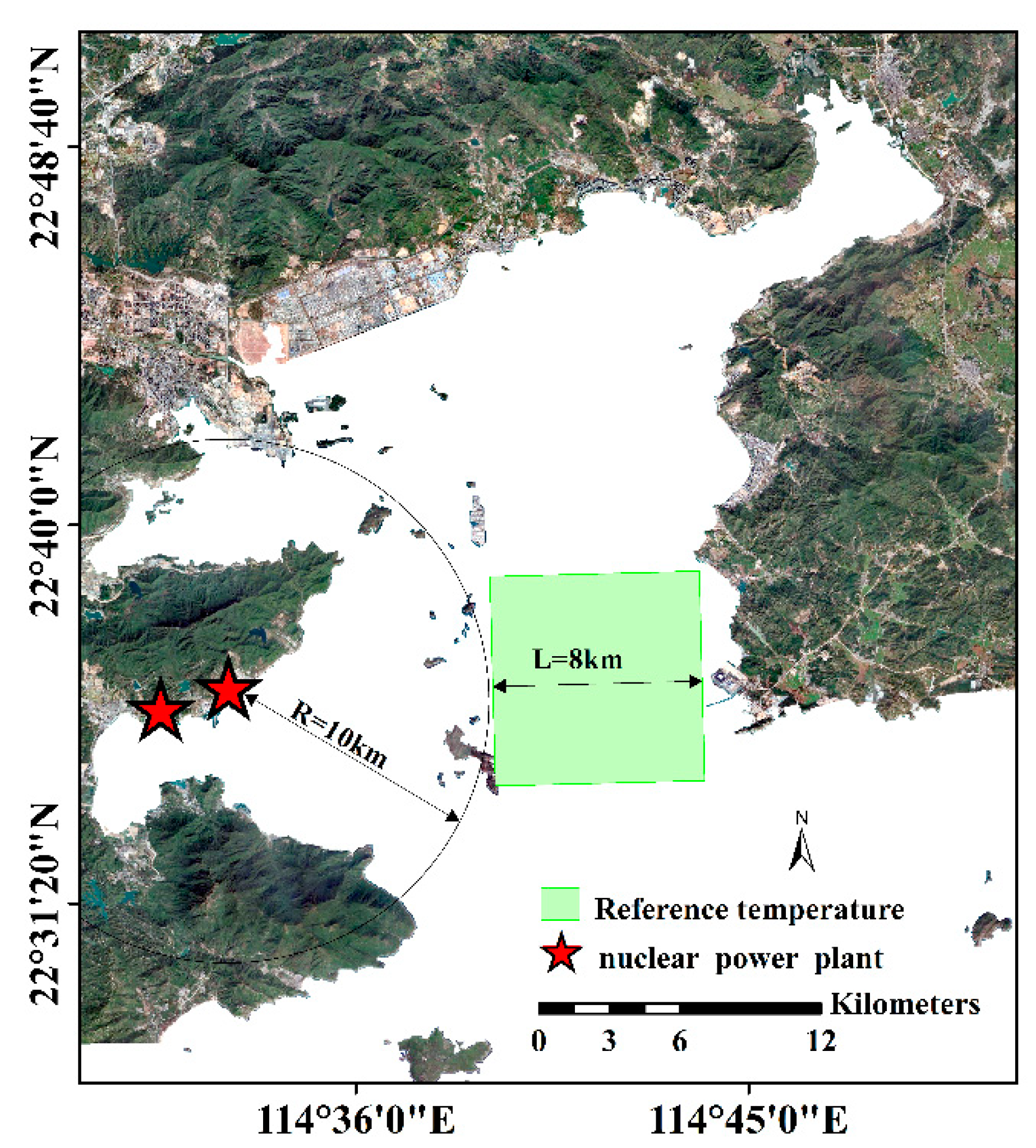
The background temperature selected in an investigation of the thermal discharge from an NPP must be close to the natural temperature in the area in the absence of the NPP [29]. Because Daya Bay is semi-closed, an adjacent-zone substitution method was adopted to determine a reference temperature, Tr. Specifically, the average temperature in a square zone with an area of 8 km × 8 km, located approximately 10 km from the LNPP, was selected as Tr to determine SST increases (Figure 4).

3.5. Methods for Analyzing Sea Surface Temperature Increases

Contours of increases in SST were plotted for each season (spring: March–May; summer: June–August; fall: September–November; winter: December–February of the following year) [30]. The average total area of all warming zones with SST increases ranging from 2 °C to greater than 7 °C (Atotal) and average total area of warming zones with SST increases at different levels were calculated for each season.
Similarly, annual contours of increases in SST were plotted for the period 1993 to 2020 (excluding 2012, 2013, 2014, 2015, and 2020, because data were available for only one season in each of those years and therefore were not representative) in order to analyze patterns of interannual changes in thermal discharge. To examine distributions of temperature increases more clearly and to facilitate subsequent analysis and research, different temperature levels were set. Table 2 summarizes the range for each level of SST increase. For convenience in description, average total areas of warming zones with SST increases of 2–3 °C, 3–4 °C, 4–5 °C, 5–6 °C, 6–7 °C, and >7 °C are denoted by A+2°C, A+3°C, A+4°C, A+5°C, A+6°C, and A+7°C, respectively.

4. Results

4.1. Seasonal Changes in Distribution Pattern of Thermal Discharge

Figure 5 shows seasonal contours of SST increases, plotted on the basis of seasonal averages of data retrieved from Landsat Level-1 imagery for the period 1993–2020. Table 3 shows areas of warming zones in each season. In each season, the total areas of warming zones with low SST increases (at +2 °C and +3 °C levels) were relatively large and displayed an outward fan-shaped diffusion pattern, whereas those with high SST increases (at +6 °C and +7 °C levels) were relatively small and concentrated primarily near discharge outlets of the NPPs along the shore of Daya Bay. Summer had the largest Atotal (total area with temperature increase from 2 °C to 7 °C) at 31.58 km2, with A+2°C accounting for the largest proportion (49.6%; 15.67 km2). The smallest Atotal was in winter (7.89 km2). The average total area of warming zones with SST increases at each of the +2 °C to +7 °C levels in summer was approximately four times that in winter and approximately twice that in spring and fall. The seasonal pattern was similar for Atotal.

4.2. Interannual Changes in Thermal Discharge

Because Landsat sensors are affected by factors such as clouds, Landsat data suitable for retrieval of SSTs are limited. Therefore, images that contained as much data as possible were selected to analyze interannual changes in thermal discharge. Specifically, images of at least two seasons in each year (except 1993) were used in the analysis.
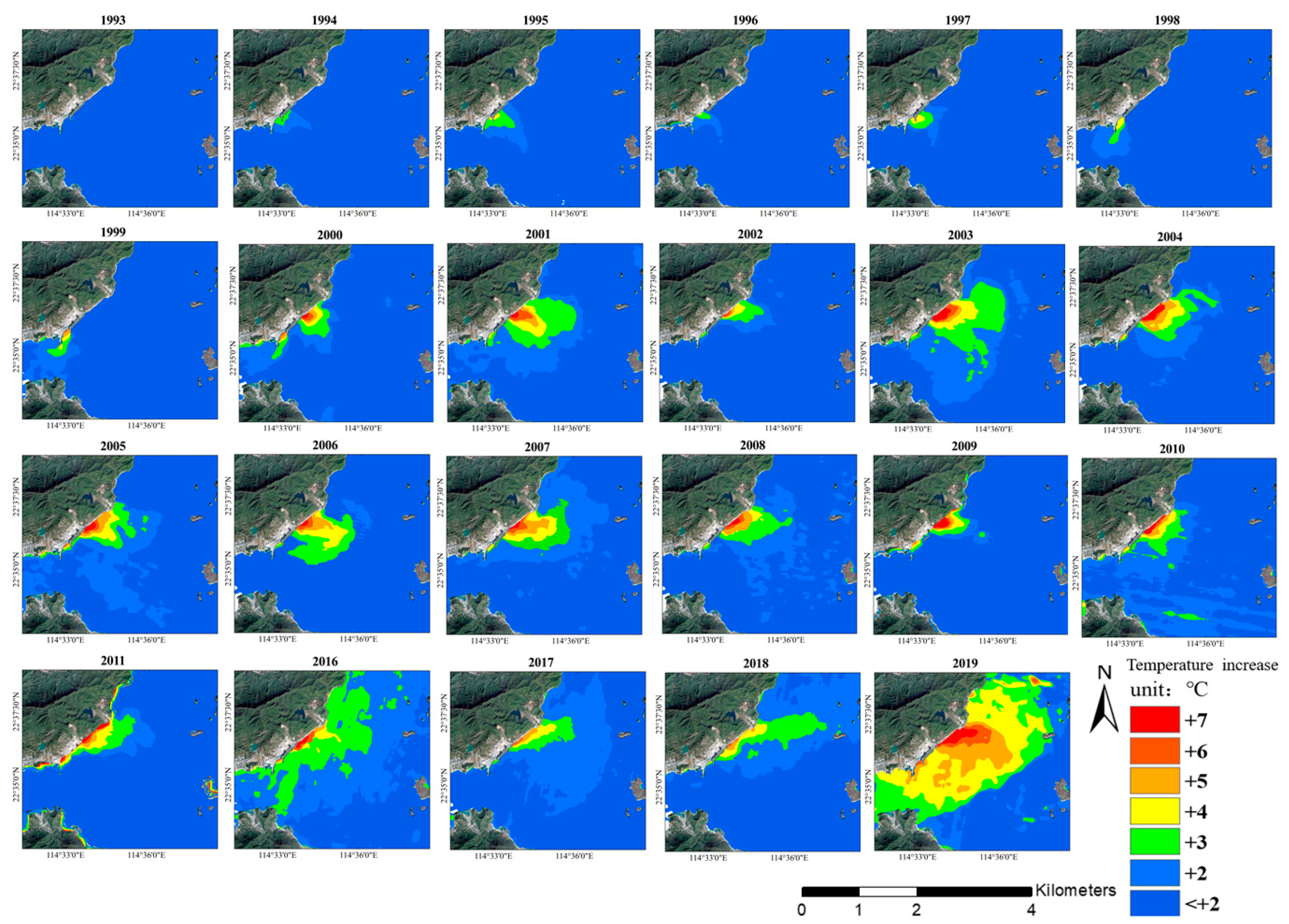
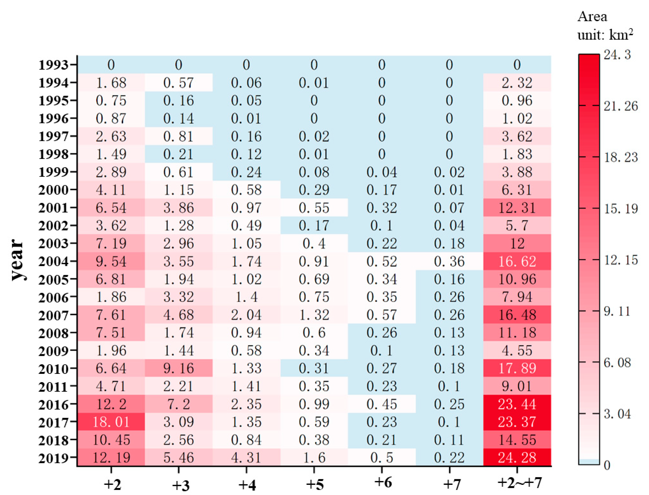
Figure 6 and Figure 7 show the interannual contours of SST increases and the interannual changes in areas of warming zones, respectively. In 1993, there were no thermal discharge-affected zones. Because the No. 1 unit of the DBNPP began operation on May 6, 1994, warm water was discharged within an extremely small zone in that year. A notable diffusion of thermal discharge began in 2000, with SST increases occurring primarily at +2 °C and +3 °C levels and at locations approximately 1.5 to 1.7 km east of the discharge outlet. Later, in 2004, with intensification of operations and an increase in installed capacity (first phase of LNPP became operational in January 2003), the zones affected by thermal discharge expanded, with SST increases occurring primarily at +2 °C to +5 °C levels. In addition, A+2°C, A+3°C, A+4°C, A+5°C, and Atotal in 2004 were approximately three times those in 2000. The warming zones in 2004 were distributed 3.5 to 3.8 km east of the discharge outlets, and SST increases at +6 °C and +7 °C levels became increasingly prominent (at locations ~0.5 km east of the discharge outlets). The second phase of LNPP was completed and began commercial service on 15 July 2010, resulting in a notable expansion of zones affected by thermal discharge. Increases in SST were at +2 °C to +4 °C levels in most of the nearby waters and were at +5 °C to +7 °C levels near the discharge outlets. In 2019, the effects of thermal discharge peaked, with Atotal also reaching its maximum (24.28 km2). Increases in SST occurred primarily at +2 °C to +5 °C levels, but there were also notable increases in A+6°C and A+7°C.

5. Discussion

5.1. Effects of Installed Capacity of Nuclear Power Plants on Thermal Discharge

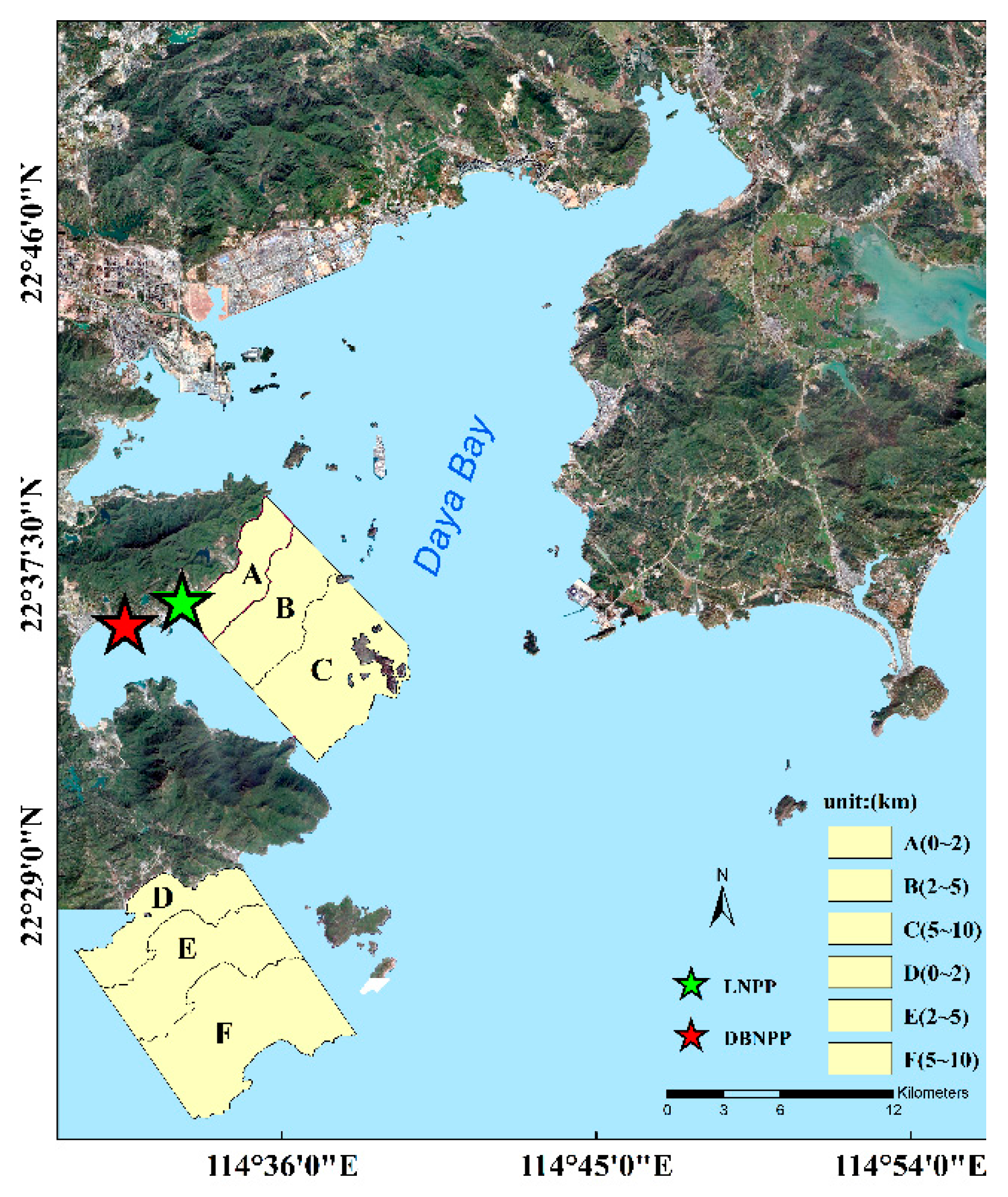
To analyze the effects of changes in installed capacity of the NPPs on thermal discharge, three test zones and three control zones, each with an area within 30 km2, were selected within different distance intervals (i.e., 0–2 km, 2–5 km, and 5–10 km) from the shoreline within the study area. The test zones were A, B, and C, respectively, and the corresponding control zones were D, E, and F (Figure 8).
With SSTs in test zone C and control zone F as references, interannual changes in SSTs were calculated based on MODIS Level-2 SST data for the period 2003 to 2020. Let ΔAC and ΔBC be the annual average SST in zone A minus that in zone C and the annual average SST in zone B minus that in zone C, respectively, with ΔDF and ΔEF similarly defined. The following equations define ΔAC, ΔBC, ΔDF, and ΔEF:
ΔAC = SSTASSTC
ΔBC = SSTBSSTC
ΔDF = SSTDSSTF
ΔEF = SSTESSTF
where SSTA, SSTB, SSTC, SSTD, SSTE, and SSTF are the annual average SSTs in zones A, B, C, D, E, and F, respectively. Annual rates of increase in SST in zones A and B (RA and RB, respectively) were defined as follow [31]:
RA = ΔAC − ΔDF
RB = ΔBC − ΔEF
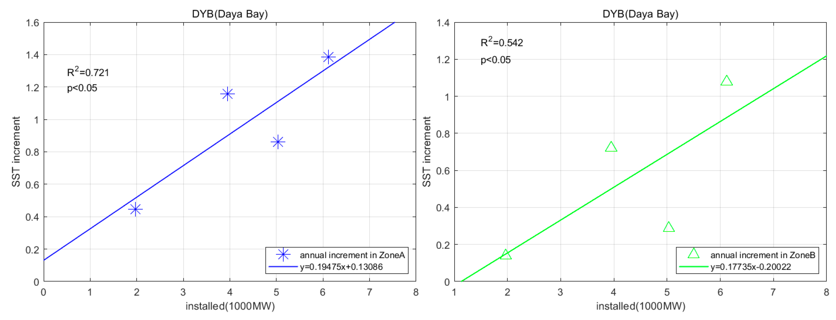
Figure 9 shows the relations between the installed capacity of the NPPs and increases in SST, determined based on changes in RA and RB.
There was a significant linear relation between the increase in SST and the installed capacity of NPPs in each of zones A and B, with the relation stronger in zone A than in zone B (Figure 9). Thus, an increase in installed capacity of the NPPs led to a greater increase in SST in zone A (i.e., within 2 km from the shoreline) than in zone B (i.e., within 2–5 km from the shoreline). In summary, an increase in installed capacity resulted in more heat released into the sea, which in turn resulted in a larger increase in SST over a larger area. This conclusion is consistent with that of Lin et al. [31].

5.2. Effects of Tides on Thermal Discharge

Tides in Daya Bay are irregular and semidiurnal, with an average height of 1.01 m and a maximum height of 2.5 m [32]. Tidal flow rate in Daya Bay decreases gradually from the mouth to the north and is relatively low at the head. Weak tidal currents dominate the waters of Daya Bay, except for those in the east, where there are relatively strong tidal currents. Specifically, tidal flow rates are approximately 30 and 20 cm/s in the eastern and western waters of Daya Bay, respectively, and range from 5 to 10 cm/s in waters near the NPPs [16].
Figure 10 shows areas of warming zones corresponding to different tidal states (peak spring flood tides (PSFTs), peak spring ebb tides (PSETs), peak neap flood tides (PNFTs), and peak neap ebb tides (PNETs)) for the period 1993–2020. Total area of warming zones with SST increases at each of the +2 °C to +7 °C levels, and Atotal was greater during ebb tides (ETs) than during flood tides (FTs). Values of A+2°C, A+4°C, A+5°C, and Atotal during PSETs compared with those during PSFTs were approximately two times higher. Those areas during PNETs were also greater than those during PNFTs. The largest and smallest Atotal values (29.23 and 14.5 km2, respectively) occurred during PNETs and PSFTs, respectively, and A+6°C and A+7°C during PSETs were approximately six times those during PSFTs.
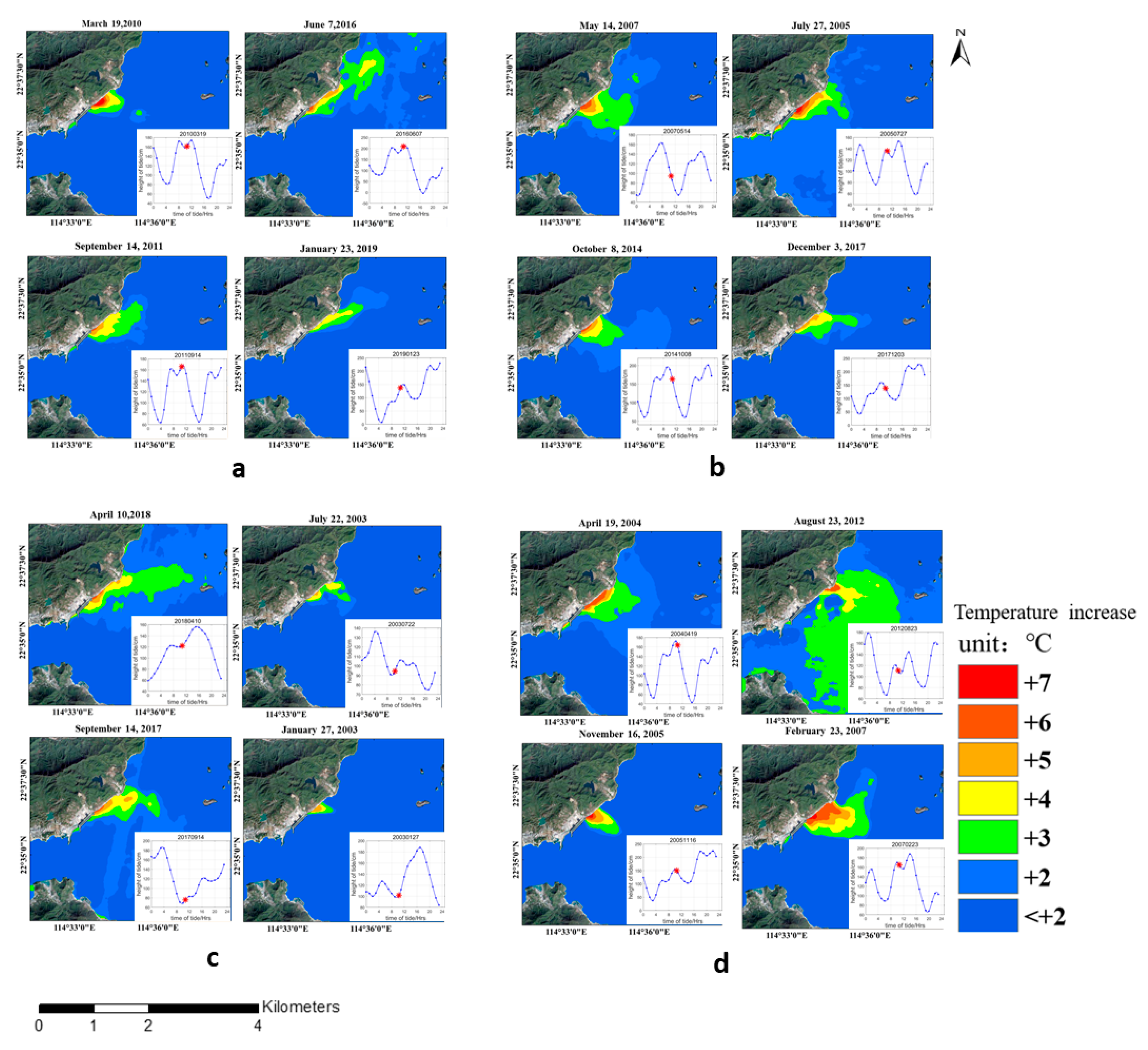
Table 4 shows the variation in areas of warming zones with tidal state and season (spring, summer, fall, and winter) for the period 1993–2020. The Atotal was greater during peak ETs (PETs), both PSETs and PNETs, than during peak FTs (PFTs) in each season, except in fall, when Atotal was smaller during PNETs than during PNFTs. The Atotal during PETs was approximately 1.5 times that during PFTs in spring and summer, whereas Atotal during PETs was approximately twice that during PFTs in winter. The largest and smallest Atotal values (56.19 and 6.82 km2, respectively) appeared during PNETs in summer and PNFTs in winter, respectively. In summary, the effects of ETs on areas of warming zones exceeded those of FTs [33]. In addition, as shown in Figure 11, tides affected the direction of thermal discharge.

5.3. Effects of Monsoons on Thermal Discharge

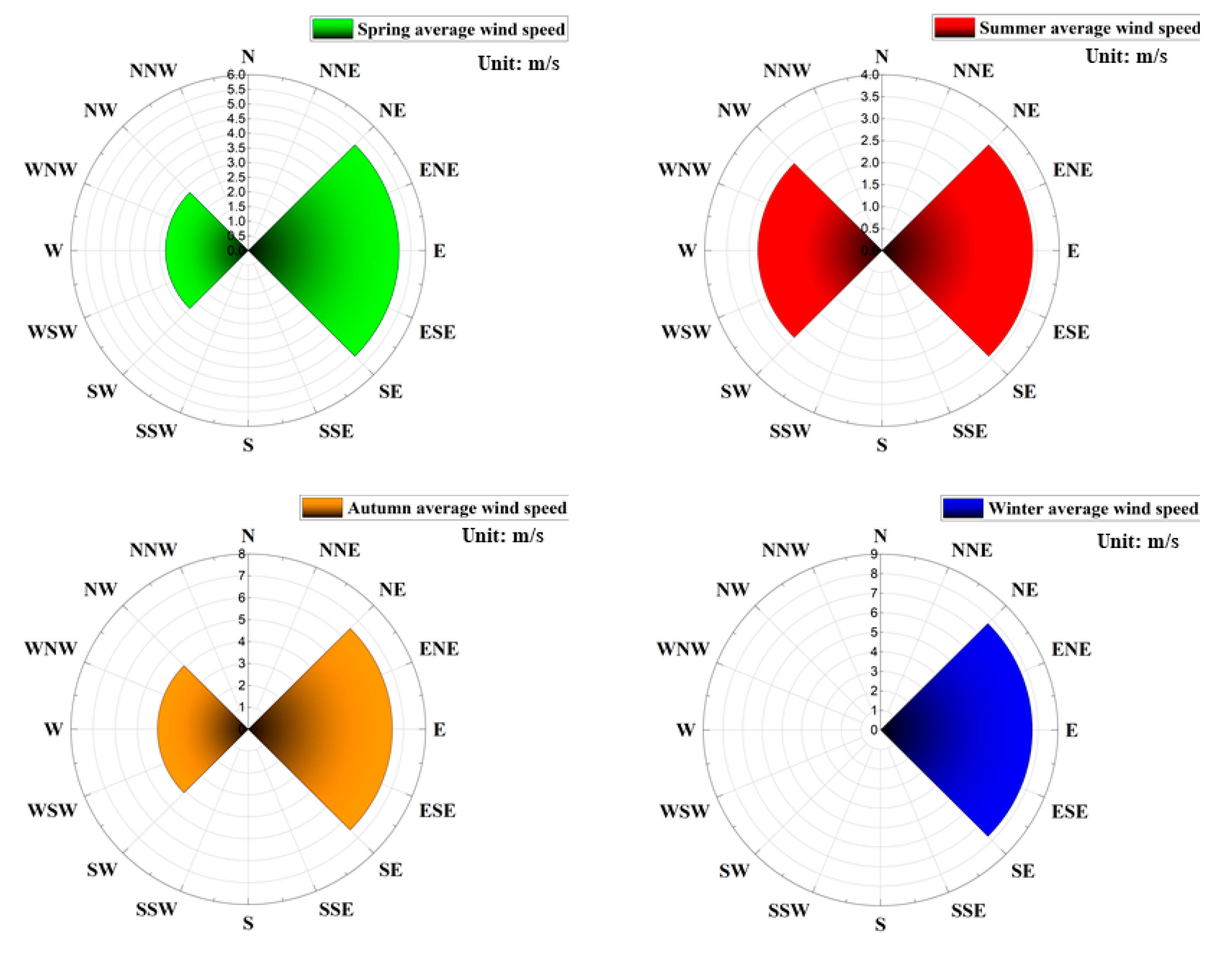
A marked monsoon climate prevails in Daya Bay. Figure 12 shows wind speeds and directions extracted from wind field data. In winter, the only winds over Daya Bay were easterlies (average speed: 7.7 m/s). In summer, most (approximately 60%) winds were from the west, with an average speed of only 3.4 m/s, whereas the rest (approximately 40%) originated from the east, with an average speed of 4.1 m/s. Figure 13 shows areas of warming zones corresponding to different wind speeds. In summer, Atotal was approximately twice that in spring, regardless of whether winds were favorable (westerly) or adverse (easterly). In addition, in summer, Atotal was greater with adverse winds than with favorable winds, which might be because the effects of tides on thermal discharge exceeded those of winds [34]. Under adverse winds, the areas of warming zones with low SST increases (i.e., A+2°C and A+3°C), those of warming zones with high SST increases (i.e., A+6°C and A+7°C), and Atotal in summer were approximately five times those in winter. Several factors could explain those results. In summer, the waters of Daya Bay have inherently relatively higher temperatures, resulting in relatively poor conditions for seawater exchange. Exchange between seawater within Daya Bay and open seawater occurs primarily through the mouth of the bay. Moreover, the tidal range is small in summer, and changes in tidal currents are controlled by tides [6]. In spring, Atotal under favorable winds differed from that under adverse winds by 1.35 km2, and in fall, Atotal under favorable winds was 70% greater than that under adverse winds.
Table 4, Figure 10 and Figure 13 were combined to produce Table 5. In spring, total area of warming zones with SST increases at each of the +2 °C to +7 °C levels and Atotal during PETs (PSETs and PNETs) were twice the respective seasonal averages, whereas A+3°C and Atotal under favorable winds were only ~30% greater than the respective seasonal averages. In summer, during PETs (PSETs and PNETs), A+3°C and Atotal values were ~50% greater than those of respective seasonal averages. However, under favorable winds in summer, A+4°C and A+6°C were, to some extent, greater than the respective seasonal averages, whereas areas at other temperatures were below respective seasonal averages. In fall, during PETs, A+2°C, A+3°C, and Atotal values were approximately twice those of respective seasonal averages. However, under favorable winds in fall, only A+2°C was approximately twice the seasonal average, whereas areas at other temperatures differed only slightly from respective seasonal averages. In winter, when all winds over Daya Bay are adverse, A+2°C and Atotal values during ETs were approximately twice those of respective seasonal averages.
In summary, the effects of tides on seasonal areas of warming zones exceeded those of favorable winds, suggesting that the effects of tides on the diffusion of thermal discharge surpass those of winds. In addition, the shapes and distributions of warming zones depended primarily on tides instead of winds.

6. Conclusions

Seasonal and interannual changes and the factors influencing changes in thermal discharge from the NPPs in Daya Bay were examined for the period 1993–2020. The conclusions are summarized below.
(1) As indicated by an R2 value of 0.89, the SST inversion algorithm of Landsat-5 and -7 imagery could adequately retrieve temperature-increase data for Daya Bay.
(2) Temporal and spatial analyses of the retrieved time series data from the period 1993 to 2020 revealed that the range of warming zones has expanded to a certain extent. In terms of interannual changes, SSTs increased as the installed capacity of the NPPs increased. There was a relatively significant linear relation between SST and the installed capacity of the NPPs. An increase in installed capacity resulted in more heat released into the sea, which in turn resulted in a considerable increase in SST over a relatively large area. Warming zones with SST increases at +5 °C to +7 °C levels have remained near discharge outlets of the NPPs since 2000. In 2019, the effects of thermal discharge from the NPPs peaked, and Atotal also reached its maximum (24.28 km2). Increases in SST occurred primarily at the +2 °C to +5 °C levels, but there was also a notable increase in A+6°C and A+7°C.
(3) The effects of tides on areas of warming zones exceeded those of winds. Specifically, both FTs (PSFTs and PNFTs) and ETs (PSETs and PNETs) affected areas of warming zones. The highest and lowest values of Atotal (29.23 and 14.5 km2, respectively) occurred during PNETs and PSFTs, respectively. Atotal was greater during PETs (both PSETs and PNETs) than during PFTs in each season, except in fall, when Atotal was smaller during PNETs than during PNFTs. Therefore, the effects of ETs on areas of warming zones exceeded those of FTs. Favorable winds promoted the diffusion of thermal discharge, whereas adverse winds inhibited it and could even alter the original direction of diffusion. Under either favorable (westerly) or adverse (easterly) winds, Atotal in summer was approximately twice that in spring. In addition, warming zones in summer were larger under adverse winds than under favorable winds.
Therefore, if we want to minimize the warming zone area, we must focus on the dynamic environment first. For example, reducing land reclamation in the Daya Bay and reducing seabed sedimentation may be more effective approaches.

Author Contributions

Conceptualization, D.W.; methodology, Z.Z.; software, validation, Z.Z.; formal analysis, Z.Z. and F.G.; resources, F.G. and D.W.; writing—original draft preparation, Z.Z.; writing—review and editing, D.W. and Y.C.; supervision, project administration, and funding acquisition, D.W. All authors have read and agreed to the published version of the manuscript.

Funding

This research was funded by the National Key R&D Program of China, grant nos. 2017YFC1405300 and 2018YFB0505005; the Key Research and Development Plan of Zhejiang Province, contract no. 2017C03037; the National Natural Science Foundation of China, contract nos. 41476157 and 41776029; and the Marine Science and Technology Cooperation Project between the Maritime Silk Route and island countries based on marine sustainability.

Data Availability Statement

Not applicable.

Acknowledgments

The authors thank the USGS (United States Geological Survey) and NASA (National Aeronautics and Space Administration) for excellent Landsat and MODIS data, respectively. We also thank the satellite ground station and the satellite data processing and sharing center of SOED/SIO for help with data processing. Our deepest gratitude goes to the editors and reviewers for their careful work and thoughtful suggestions.

Conflicts of Interest

The authors declare no conflict of interest.

Appendix A

Table A1. Matching MODIS Sea surface temperature (SST) and Landsat files.
MODIS Product FileLandsat FileMODIS Product FileLandsat File
AQUA_MODIS.20030722T051506.L2.SST.ncLT05_L1TP_121044_20030722_20161205_01_T1AQUA_MODIS.20030823T051506.L2.SST.ncLT05_L1TP_121044_20030823_20161204_01_T1
AQUA_aODIS.20031028T050505.L2.SST.ncLT05_L1TP_121044_20031026_20161204_01_T1AQUA_MODIS.20031213T052006.L2.SST.ncLT05_L1TP_121044_20031213_20161204_01_T1
AQUA_MODIS.20040213T053006.L2.SST.ncLT05_L1TP_121044_20040215_20161202_01_T1AQUA_MODIS.20040422T055006.L2.SST.ncLT05_L1TP_121044_20040419_20161201_01_T1
AQUA_MODIS.20040926T052006.L2.SST.ncLT05_L1TP_121044_20040926_20161129_01_T1AQUA_MODIS.20030823T051506.L2.SST.ncLT05_L1TP_121044_20041012_20161129_01_T1
AQUA_MODIS.20041013T060005.L2.SST.ncLT05_L1TP_121044_20041012_20161129_01_T1AQUA_MODIS.20041129T052006.L2.SST.ncLT05_L1TP_121044_20041129_20161128_01_T1
AQUA_MODIS.20041215T052006.L2.SST.ncLT05_L1TP_121044_20041215_20161127_01_T1AQUA_MODIS.20050116T052006.L2.SST.ncLT05_L1TP_121044_20050116_20161128_01_T1
AQUA_MODIS.20050306T060006.L2.SST.ncLT05_L1TP_121044_20050305_20161128_01_T1AQUA_MODIS.20051013T053006.L2.SST.ncLT05_L1TP_121044_20051015_20161124_01_T1
AQUA_MODIS.20061019T060508.L2.SST.ncLT05_L1TP_121044_20061018_20161119_01_T1AQUA_MODIS.20061205T052008.L2.SST.ncLT05_L1TP_121044_20061205_20161117_01_T1
AQUA_MODIS.20061221T052008.L2.SST.ncLT05_L1TP_121044_20061221_20161118_01_T1AQUA_MODIS.20070207T052008.L2.SST.ncLT05_L1TP_121044_20070207_20161117_01_T1
AQUA_MODIS.20070223T052007.L2.SST.ncLT05_L1TP_121044_20070223_20161116_01_T1AQUA_MODIS.20070514T052007.L2.SST.ncLT05_L1TP_121044_20070514_20161115_01_T1
AQUA_MODIS.20071005T052007.L2.SST.ncLT05_L1TP_121044_20071005_20161110_01_T1AQUA_MODIS.20080516T052006.L2.SST.ncLT05_L1TP_121044_20080516_20161031_01_T1
AQUA_MODIS.20081023T052506.L2.SST.ncLT05_L1TP_121044_20081023_20161029_01_T1AQUA_MODIS.20081210T052506.L2.SST.ncLT05_L1TP_121044_20081210_20161028_01_T1
AQUA_MODIS.20090111T052508.L2.SST.ncLT05_L1TP_121044_20090111_20161028_01_T1AQUA_MODIS.20091010T052508.L2.SST.ncLT05_L1TP_121044_20091010_20161019_01_T1
AQUA_MODIS.20101029T052007.L2.SST.ncLT05_L1TP_121044_20101029_20161012_01_T1AQUA_MODIS.20101130T052008.L2.SST.ncLT05_L1TP_121044_20101130_20161012_01_T1
AQUA_MODIS.20110101T052008.L2.SST.ncLT05_L1TP_121044_20110101_20161011_01_T1AQUA_MODIS.20110202T052007.L2.SST.ncLT05_L1TP_121044_20110202_20161010_01_T1
AQUA_MODIS.20110407T052008.L2.SST.ncLT05_L1TP_121044_20110407_20161208_01_T1AQUA_MODIS.20110914T052007.L2.SST.ncLT05_L1TP_121044_20110914_20161006_01_T1
AQUA_MODIS.20121009T052509.L2.SST.ncLE07_L1TP_121044_20121010_20161128_01_T1AQUA_MODIS.20131005T052009.L2.SST.ncLC08_L1TP_121044_20131005_20170429_01_T1
AQUA_MODIS.20141008T052008.L2.SST.ncLC08_L1TP_121044_20141008_20180205_01_T1AQUA_MODIS.20141125T052000.L2.SST.ncLC08_L1TP_121044_20141125_20170417_01_T1
AQUA_MODIS.20150925T052009.L2.SST.ncLC08_L1TP_121044_20150925_20170403_01_T1AQUA_MODIS.20160623T052009.L2.SST.ncLC08_L1TP_121044_20160623_20170323_01_T1
AQUA_MODIS.20161216T052010.L2.SST.ncLC08_L1TP_121044_20161216_20180205_01_T1AQUA_MODIS.20170102T060511.L2.SST.ncLC08_L1TP_121044_20170101_20170312_01_T1
AQUA_MODIS.20171101T052010.L2.SST.ncLC08_L1TP_121044_20171101_20171109_01_T1AQUA_MODIS.20171117T052010.L2.SST.ncLC08_L1TP_121044_20171117_20171122_01_T1
AQUA_MODIS.20171203T052001.L2.SST.ncLC08_L1TP_121044_20171203_20171207_01_T1AQUA_MODIS.20171219T052001.L2.SST.ncLC08_L1TP_121044_20171219_20171224_01_T1
AQUA_MODIS.20180309T052001.L2.SST.ncLC08_L1TP_121044_20180309_20180320_01_T1AQUA_MODIS.20181003T052001.L2.SST.ncLC08_L1TP_121044_20181003_20181010_01_T1
AQUA_MODIS.20190123T052001.L2.SST.ncLC08_L1TP_121044_20190123_20190205_01_T1AQUA_MODIS.20190312T052001.L2.SST.ncLC08_L1TP_121044_20190312_20190325_01_T1
AQUA_MODIS.20190920T052000.L2.SST.ncLC08_L1TP_121044_20190920_20190926_01_T1AQUA_MODIS.20191022T052001.L2.SST.ncLC08_L1TP_121044_20191022_20191030_01_T1
AQUA_MODIS.20191123T052001.L2.SST.ncLC08_L1TP_121044_20191123_20191203_01_T1

References

  1. Liang, S.S.; Zhang, B.; Li, J.S.; Zhang, H.; Shen, Q. Distribution of therm-water pollution of nuclear powerplant using the thermal infrared Band of HJ-IRS data-taking Daya Bay as an example. Remote Sens. Inf. 2012, 2, 43–48. [Google Scholar]
  2. Verones, F.; Hanafiah, M.M.; Pfister, S.; Huijbregts, M.A.J.; Pelletier, G.J.; Koehler, A. Characterization factors for thermal pollution in freshwater aquatic environments. Environ. Sci. Technol. 2010, 44, 9364–9369. [Google Scholar] [CrossRef] [PubMed]
  3. McMillin, L.M. Estimation of sea surface temperatures from two infrared window measurements with different absorption. J. Geophys. Res. 1975, 80, 80–82. [Google Scholar] [CrossRef]
  4. Loncan, L.; de Almeida, L.B.; Bioucas-Dias, J.M.; Briottet, X.; Chanussot, J.; Dobigeon, N.; Fabre, S.; Liao, W.; Licciardi, G.A.; Simoes, M.; et al. Hyperspectral pansharpening: A review. IEEE Geosci. Remote Sens. Mag. 2015, 3, 27–46. [Google Scholar] [CrossRef] [Green Version]
  5. Liu, L.; Zhou, J. Using MODIS imagery to map sea surface temperature. Geospat. Inf. 2006, 4, 7–9. [Google Scholar]
  6. Rozenstein, O.; Qin, Z.; Derimian, Y.; Karnieli, A. Derivation of land surface temperature for Landsat-8 TIRS using a split window algorithm. Sensors 2014, 14, 5768–5780. [Google Scholar] [CrossRef]
  7. Chen, H.; Zhu, L.; Li, J.; Fan, X. A comparison of two mono-window algorithms for retrieving sea surface temperature from Landsat8 data in coastal water of Hongyan River nuclear power station. Remote Sens. Land Resour. 2018, 30, 45–53. [Google Scholar]
  8. Ai, B.; Wen, Z.; Jiang, Y.; Gao, S.; Lv, G. Sea surface temperature inversion model for infrared remote sensing images based on deep neural network. Infrared Phys. Technol. 2019, 99, 231–239. [Google Scholar] [CrossRef]
  9. Zhang, H.R.; Zhao, Y.; Yang, H.; Chen, B.R.; Ding, J.; Dai, G.X.; Chuan, P.J. Study on the temperature rise characteristics and influence effects of thermal discharge from coastal power plant in Xiangshan Bay. J. Shanghai Ocean Univ. 2013, 22, 274–281. [Google Scholar]
  10. Jia, H.L.; Zheng, S.; Xie, J.; Ying, X.M.; Zhang, C.P. Influence of geographic setting on thermal discharge from coastal power plants. Mar. Pollut. Bull. 2016, 111, 106–114. [Google Scholar] [CrossRef]
  11. Liu, R.; Wang, Y.G.; Huang, H.M.; Hua, X. Research on effect of water depthand flow intensity in coastal power plant outfall on warming area. J. Waterway Harbor 2017, 38, 26–30. [Google Scholar]
  12. Lentz, S.J.; Largier, J. The influence of wind forcing on the Chesapeake Bay buoyant coastal current. J. Phys. Oceanogr. 2006, 36, 1305–1316. [Google Scholar] [CrossRef]
  13. Jiang, R.; Wang, Y. Modeling the ecosystem response of the semi-closed Daya Bay to the thermal discharge from two nearby nuclear power plants. Ecotoxicology 2020, 29, 736–750. [Google Scholar] [CrossRef]
  14. Zhang, X.; Zhang, J.; Shen, Y.; Zhou, C.; Huang, X. Dynamics of alkaline phosphatase activity in relation to phytoplankton and bacteria in a coastal embayment Daya Bay, South China. Mar. Pollut. Bull. 2018, 131, 736–744. [Google Scholar] [CrossRef] [PubMed]
  15. Ye, Y.; Chen, K.; Zhou, Q.; Xiang, P.; Huo, Y.; Lin, M. Impacts of thermal discharge on phytoplankton in Daya Bay. J. Coast. Res. 2019, 83, 135–147. [Google Scholar] [CrossRef]
  16. Wu, C.; Wang, Q.; Yang, Z.; Wang, W. Monitoring heated water pollution of the DaYaWan nuclear power plant using TM images. Int. J. Remote Sens. 2007, 28, 885–890. [Google Scholar] [CrossRef]
  17. Liu, M.; Yin, X.; Xu, Q.; Chen, Y.; Wang, B. Monitoring of fine-scale warm drain-off water from nuclear power stations in the Daya Bay based on Landsat 8 data. Remote Sens. 2020, 12, 627. [Google Scholar] [CrossRef] [Green Version]
  18. Fu, J.; Chen, C.; Guo, B.; Chu, Y.; Zheng, H. A split-window method to retrieving sea surface temperature from Landsat 8 thermal infrared remote sensing data in offshore waters. Estuar. Coast. Shelf Sci. 2020, 236, 106626. [Google Scholar] [CrossRef]
  19. Schott, J.R.; Volchok, W.J. Thematic Mapper thermal infrared calibration. Photogramm. Eng. Remote Sens. 1985, 51, 1351–1357. [Google Scholar]
  20. Sobrino, J.A.; Jiménez-Muñoz, J.C.; Paolini, L. Land surface temperature retrieval from Landsat TM 5. Remote Sens. Environ. 2004, 90, 434–440. [Google Scholar] [CrossRef]
  21. Sekertekin, A.; Bonafoni, S. Land surface temperature retrieval from Landsat 5, 7, and 8 over rural areas: Assessment of different retrieval algorithms and emissivity models and toolbox implementation. Remote Sens. 2020, 12, 294. [Google Scholar] [CrossRef] [Green Version]
  22. Yu, X.; Guo, X.; Wu, Z. Land surface temperature retrieval from Landsat 8 TIRS-comparison between radiative transfer equation-based method, split window algorithm and single channel method. Remote Sens. 2014, 6, 9829–9852. [Google Scholar] [CrossRef] [Green Version]
  23. Sobrino, J.; Li, Z.; Stoll, M.; Becker, F. Multi-channel and multi-angle algorithms for estimating sea and land surface temperature with ATSR data. Int. J. Remote Sens. 1996, 17, 2089–2114. [Google Scholar] [CrossRef]
  24. Arabi Aliabad, F.; Zare, M.; Ghafarian Malamiri, H. A comparative assessment of the accuracies of split-window algorithms for retrieving of land surface temperature using Landsat 8 data. Model. Earth Syst. Environ. 2021, 7, 2267–2281. [Google Scholar] [CrossRef]
  25. Kerr, Y.H.; Lagouarde, J.P.; Imbernon, J. Accurate land surface temperature retrieval from AVHRR data with use of an improved split window algorithm. Remote Sens. Environ. 1992, 41, 197–209. [Google Scholar] [CrossRef]
  26. Qin, Z.; Karnieli, A.; Berliner, P. A mono-window algorithm for retrieving land surface temperature from Landsat TM data and its application to the Israel-Egypt border region. Int. J. Rem. Sens. 2001, 22, 3719–3746. [Google Scholar] [CrossRef]
  27. Jimenez-Munoz, J.C.; Cristobal, J.; Sobrino, J.A.; Soria, G.; Ninyerola, M.; Pons, X.; Pons, X. Revision of the Single-Channel Algorithm for Land Surface Temperature Retrieval from Landsat Thermal-Infrared Data. IEEE Trans. Geosci. Remote Sens. 2009, 47, 339–349. [Google Scholar] [CrossRef]
  28. Li, X.; Ling, T.; Zhang, Y.; Zhou, Q. A 31-year global diurnal sea surface temperature dataset created by an ocean mixed-Layer model. Adv. Atmos. Sci. 2018, 35, 1443–1454. [Google Scholar] [CrossRef]
  29. Zhou, Y.; Gong, C.; Kuang, D.; Hu, Y. Research on the distribution of temperature and drainage of nuclear power plants based on the thermal infrared band data of environmental disaster mitigation satellites. J. Infrared Millim. Waves 2012, 31, 544–549. [Google Scholar] [CrossRef]
  30. Wang, R.; Yang, H.; Zhu, L.; Wu, C.; Chen, Y. Application of temperature rise envelop in thermal discharge from nuclear power plant. Environ. Monit. Manag. Technol. 2020, 32, 49–52. [Google Scholar] [CrossRef]
  31. Lin, J.; Zou, X.; Huang, F.; Yao, Y. Quantitative estimation of sea surface temperature increases resulting from the thermal discharge of coastal power plants in China. Mar. Pollut. Bull. 2021, 164, 112020. [Google Scholar] [CrossRef] [PubMed]
  32. Chen, C.S.; Liu, H.D.; Beardsley, R.C. An unstructured grid, finite-volume, three-dimensional, primitive equations ocean model: Application to coastal ocean and estuaries. J. Atmos. Ocean. Technol. 2003, 20, 159–186. [Google Scholar] [CrossRef]
  33. Wang, G.L.; Xiong, X.J. Distribution and variation of warm water discharge in the coastal area of Tianwan. Adv. Mar. Sci. 2013, 31, 69–74. [Google Scholar]
  34. Xie, F.; Liu, H.; Huang, H.; Song, X. Effects of thermal discharge and nutrients input on size structure of phytoplankton in Daya Ba. J. Trop. Oceanogr. 2008, 37, 55–64. [Google Scholar] [CrossRef]
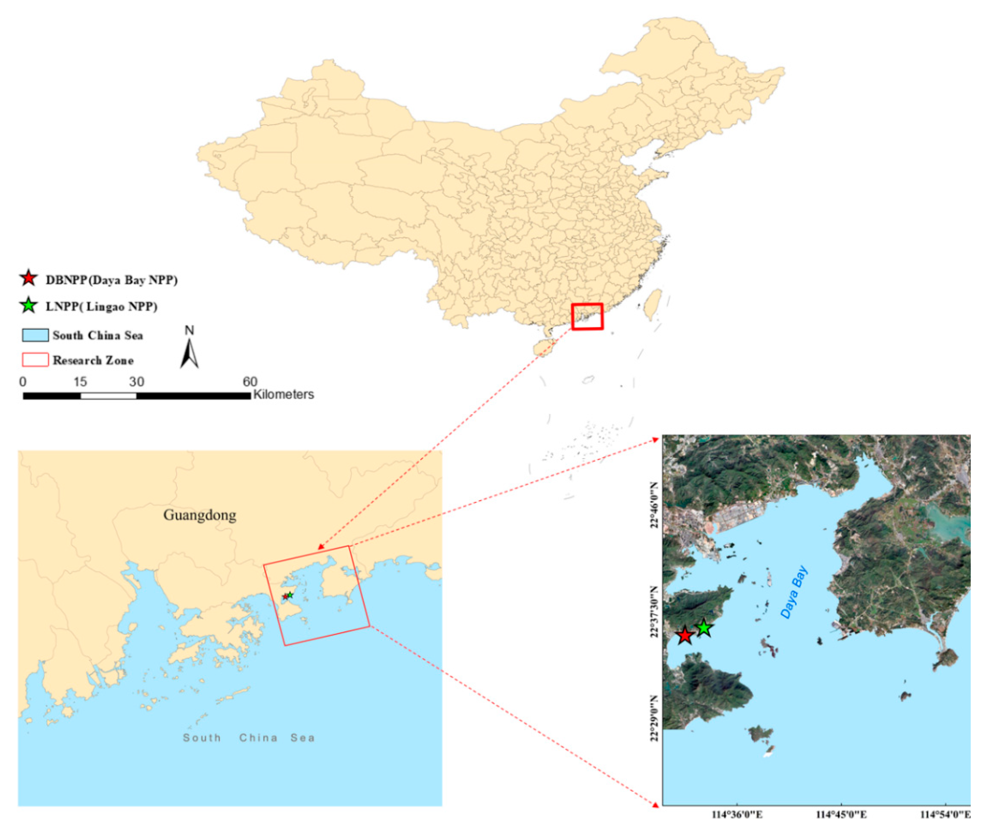
Figure 1. Geographic location of Daya Bay, China.
Remotesensing 14 00763 g001
Figure 2. Amount of Landsat images of Daya Bay in spring (green), summer (red), autumn (orange), and winter (blue) from 1993 to 2020.
Remotesensing 14 00763 g002
Figure 3. Relation between Landsat sea surface temperature (SST, °C) and MODIS SST product. Blue line is the regression line (y = 1.058x − 2.269); red line is the 1:1 line (y = x).
Remotesensing 14 00763 g003
Figure 4. Reference zone for background temperature (Tr) to determine increases in sea surface temperature.
Remotesensing 14 00763 g004
Figure 5. Seasonal changes (spring, summer, autumn, winter) in sea surface temperature (°C) contours for 1the period 993–2020.
Remotesensing 14 00763 g005
Figure 6. Interannual changes in sea surface temperature (°C) contours of areas of warming zones from the period 1993 to 2019.
Remotesensing 14 00763 g006
Figure 7. Interannual changes in areas of warming zones for the period 1993 to 2019.
Remotesensing 14 00763 g007
Figure 8. Schematic of test zones (A, B, C) and control zones (D, E, F), which are used to analyze the effects of changes in installed capacity of the NPPs on thermal discharge.
Remotesensing 14 00763 g008
Figure 9. Relation between installed capacity of nuclear power plants and increase in sea surface temperature (SST).
Remotesensing 14 00763 g009
Figure 10. Total area of warming zones and areas of warming zones at different levels of sea surface temperature increase in different tidal states.
Remotesensing 14 00763 g010
Figure 11. Areas of warming zones in different tidal states (images are for typical tidal states in different seasons): (a) peak spring flood tides; (b) peak spring ebb tides; (c) peak neap flood tides; (d) peak neap ebb tides.
Remotesensing 14 00763 g011
Figure 12. Average wind speed (m/s) in different seasons over Daya Bay, China.
Remotesensing 14 00763 g012
Figure 13. Areas of warming zones corresponding to different wind direction in different seasons (A, B, C, D, E, F, and G are spring westerlies, spring easterlies, summer westerlies, summer easterlies, autumn westerlies, autumn easterlies, and winter easterlies, respectively).
Remotesensing 14 00763 g013
Table 1. Installed capacity data for the Daya Bay (DB) and Lingao (L) nuclear power plants (NPPs) in Daya Bay, China.
SchemeCooling Water Flow Rate (m3 s1)Total Installed Capacity (MW)Installed Capacities in Different Periods (MW)
DBNPP31961201968
LNPP329Phase 1: 1980
Phase 2: 2172
Table 2. Temperature ranges (°C) for different levels of increases in sea surface temperature (SST).
Range of SST Increases (>Tr)Level (>Tr)
<2 °C<2 °C
[+2 °C, +3 °C]+2 °C
[+3 °C, +4 °C]+3 °C
[+4 °C, +5 °C]+4 °C
[+5 °C, +6 °C]+5 °C
[+6 °C, +7 °C]+6 °C
>7 °C+7 °C
Table 3. Total area (Atotal) of warming zones and areas of warming zones at different temperature levels (A+2°C to A+7°C) in each season for the period 1993–2020.
Season\Area
(km2)
A+2°CA+3°CA+4°CA+5°CA+6°CA+7°CAtotal
Spring8.833.61.81.060.440.316.03
Summer15.679.493.291.370.791.031.58
Fall9.43.511.690.640.550.5616.35
Winter4.231.840.940.40.290.197.89
Table 4. Total area (Atotal) of warming zones and areas of warming zones at different levels of sea surface temperature increase (A+2°C to A+7°C) in different tidal states and seasons.
Season\Area (km2)Tidal StateA+2°CA+3°CA+4°CA+5°CA+6°CA+7°CAtotal
SpringSTsFTs12.22 3.15 2.28 0.62 0.71 0.27 19.25
ETs18.149.363.211.930.650.2533.54
NTsFTs13.80 3.60 1.53 0.55 0.33 0.19 20.0
ETs11.817.015.353.321.51.0730.06
SummerSTsFTs7.81 13.01 1.29 0.60 0.26 0.10 23.07
ETs7.8811.3612.970.510.420.1733.31
NTsFTs16.74 8.95 3.63 1.02 0.46 0.29 31.09
ETs36.017.851.910.570.450.2656.19
FallSTsFTs3.67 2.60 1.21 0.39 0.38 0.18 8.43
ETs20.426.771.750.690.370.1730.17
NTsFTs15.58 3.79 0.69 0.65 0.28 0.16 21.15
ETs7.681.930.960.620.230.1811.6
WinterSTsFTs6.01 1.89 1.09 0.25 0.04 0.02 9.3
ETs13.391.61.060.370.050.0116.48
NTsFTs2.73 2.21 0.80 0.51 0.48 0.09 6.82
ETs7.52.711.670.330.120.1612.49
Table 5. Changes in total area (Atotal) of warming zones and areas of warming zones at different levels of sea surface temperature increase (A+2°C to A+7°C) under different tide and wind conditions.
SeasonConditionsA+2°C
(km2)
A+3°C
(km2)
A+4°C
(km2)
A+5°C
(km2)
A+6°C
(km2)
A+7°C
(km2)
Atotal
(km2)
SpringAverage8.833.61.81.060.440.316.03
ETs14.988.184.282.621.010.6631.73
Favorable winds9.514.722.381.811.20.8720.28
SummerAverage15.679.493.291.370.791.031.58
ETs21.9514.615.41.541.040.645.14
Favorable winds14.749.314.810.571.580.8626.49
FallAverage9.43.511.690.640.550.5616.35
ETs20.426.771.750.690.370.1730.17
Favorable winds18.973.641.70.820.320.1723.1
WinterAverage4.231.840.940.40.290.197.89
ETs10.452.161.370.350.090.0914.51
Publisher’s Note: MDPI stays neutral with regard to jurisdictional claims in published maps and institutional affiliations.