Assessment of Land Use Land Cover Changes for Predicting Vulnerable Agricultural Lands in River Basins of Bangladesh Using Remote Sensing and a Fuzzy Expert System
Abstract
1. Introduction
2. Materials and Methods
2.1. Study Area
2.2. Research Framework
2.2.1. Land Use Land Cover Change Assessment
| Algorithm 1: “Image retrival of Landsat 5 or 8, False color composite image preparation and LULC map preparation for 1995” | |
| Script | |
| 1 | var L5 or L8 = ee.imagecollection(“Collection Snippet for landsat 5 or 8”) |
| 2 | .filterBounds (ROI) |
| 3 | .filterDate (“start date”, “end date”) |
| 4 | .filterMetadata(‘CLOUD_COVER’,’less_than’, 1) |
| 5 | .mean() |
| 6 | .clip(ROI) |
| 7 | Map.addLayer(L5 or 8, {bands:[“B4”, “B3”, “B2”]}); |
| 8 | var training_points =landuse class1.merge(landuse class2).merge(..); |
| 9 | var training_data = L5.sampleRegions({collection:training_points,properties:[‘LC’],scale:30}) |
| 10 | var classifier = ee.Classifier.smileCart() |
| 11 | var classifier = classifier.train({features:training_data,classProperty: ‘LC’,inputProperties:[“B1”, “B2”, “B3”, “B4”, “B5”, “B6”, “B7”]}); |
| 12 | var classified_image = L5 or L8.classify(classifier); |
| 13 | Map.addLayer(classified_image,{min:0, max:4, palette:[ ‘colour1’, ‘colour2’, ‘colour3’, ‘colour4’, ‘colour’]},’classified image’); |
| Run | |
| Algorithm 2: “Image retrival of Landsat 5 or 8, False color composite image preparation and LULC map preparation for 2021” | |
| Script | |
| 1 | var L5 or L8 = ee.imagecollection(“Collection Snippet for landsat 5 or 8”) |
| 2 | .filterBounds (ROI) |
| 3 | .filterDate (“start date”, “end date”) |
| 4 | . filterMetadata(‘CLOUD_COVER’,’less_than’, 1) |
| 5 | .mean() |
| 6 | .clip(ROI) |
| 7 | Map.addLayer(L5 or 8, {bands:[“B4”, “B3”, “B2”]}); |
| 8 | var training_points =landuse class1.merge(landuse class2).merge(..); |
| 9 | var training_data = L5.sampleRegions({collection:training_points,properties:[‘LC’],scale:30}) |
| 10 | var classifier = ee.Classifier.smileCart() |
| 11 | var classifier = classifier.train({features:training_data,classProperty: ‘LC’,inputProperties:[“B1”, “B2”, “B3”, “B4”, “B5”, “B6”, “B7”]}); |
| 12 | var classified_image = L5 or L8.classify(classifier); |
| 13 | Map.addLayer(classified_image,{min:0, max:4, palette:[ ‘colour1’, ‘colour2’, ‘colour3’, ‘colour4’, ‘colour’]},’classified image’); |
| Run | |
| Algorithm 3: “Accuracy assessment” | |
| Script | |
| 1 | var trainingData = training_data.randomColumn(); |
| 2 | var trainSet = trainingData.filter(ee.Filter.lessThan(‘random’, 0.7)); |
| 3 | var testSet = trainingData.filter(ee.Filter.greaterThanOrEquals(‘random’, 0.7)); |
| 4 | var confusionMatrix = ee.ConfusionMatrix(testSet.classify(classifier) |
| 5 | .errorMatrix({ |
| 6 | actual: ‘LC’, |
| 7 | predicted: ‘classification’ |
| 8 | })) |
| 9 | print(‘Confusion Matrix’, confusionMatrix); |
| 10 | print(“Overall Accuracy:”, confusionMatrix.accuracy()); |
| Algorithm 4: “NDWI map preparation” | |
| Script | |
| Export | var ROI: Table shapefile |
| 1 | var L5 or L8 = ee.ImageCollection(“Collection Snippet for Landsat 5 or 8”) |
| 2 | .filterBounds(ROI) |
| 3 | .filterDate(“start date”, “end date”) |
| 4 | .filterMetadata(‘CLOUD_COVER’,’less_than’, 1) |
| 5 | .mean() |
| 6 | .clip(ROI); |
| 7 | var green = L5.select(‘B2’); or = L8.select(‘B3’); |
| 8 | var nir = L5.select(‘B4’); or = L8.select(‘B5’); |
| 9 | var ndwi = green.subtract(nir).divide(green.add(nir)).rename(‘NDWI’); |
| 10 | var ndwiParams = {min: −1, max: 1, palette: [‘black’, ‘white’, ‘blue’]}; |
| 11 | Map.addLayer(ndwi, ndwiParams, ‘NDWI image’); |
2.2.2. Vulnerability Analysis for Agricultural Land Use
Reclassification by Fuzzy Membership Function
Criteria Selection for Vulnerability Assessment for Agricultural Land Use
Normalized Difference Water Index (NDWI)
Rainfall
Elevation
Distance from the River
Fuzzy Overlay for Vulnerability Analysis of Agricultural Land Use
2.3. Accuracy Assessment
3. Results and Discussion
3.1. Land Use/Land Cover Assessment
3.2. Vulnerability Analysis for Agricultural Land Use
4. Conclusions
Author Contributions
Funding
Acknowledgments
Conflicts of Interest
Appendix A
Appendix A.1. LULC-1995
- .filterBounds(ROI).filterDate(“1995-01-01”, “1996-3-30”).filterMetadata(‘CLOUD_COVER’,’less_than’, 1).mean().clip(ROI);
- image: classified_image,description:’ExportedData’,folder:”GEE”,region: ROI,scale: 30,maxPixels: 1e13,});
Appendix A.2. LULC-2021
- .filterBounds(ROI).filterDate(“2021-01-01”, “2022-3-30”).filterMetadata(‘CLOUD_COVER’,’less_than’, 1).mean().clip(ROI);
- .errorMatrix({actual: ‘LC’,predicted: ‘classification’}));print(‘Confusion Matrix’, confusionMatrix);print(“Overall Accuracy:”, confusionMatrix.accuracy());
- image: classified_image,description:’ExportedData’,folder:”GEE”,region: ROI,scale: 30,maxPixels: 1e13,});
Appendix A.3. NDWI map for 1995 and 2021
- .filterBounds(ROI).filterDate(“1995-01-01”, “1996-3-30”).filterMetadata(‘CLOUD_COVER’,’less_than’, 1).mean().clip(ROI);var green = L5.select(‘B2’);var nir = L5.select(‘B4’);
- image: ndwi,description:’ExportedData’,folder:”GEE”,region: ROI,scale: 30,maxPixels: 1e13,});
- .filterBounds(ROI).filterDate(“2021-01-01”, “2022-3-30”).filterMetadata(‘CLOUD_COVER’,’less_than’, 1).mean().clip(ROI);
- image: ndwi,description:’ExportedData’,folder:”GEE”,region: ROI,scale: 30,maxPixels: 1e13,});
References
- Hossain, M.S.; Arshad, M.; Qian, L.; Kächele, H.; Khan, I.; Islam, M.D.I.; Mahboob, M.G. Climate change impacts on farmland value in Bangladesh. Ecol. Indic. 2020, 112, 106181. [Google Scholar] [CrossRef]
- Csaplovics, E. High-resolution space imagery for regional environmental monitoring-status quo and future trends. Int. Arch. Photogramm. Remote Sens. 1998, 32, 211–216. [Google Scholar]
- Foody, G.M. Status of land cover classification accuracy assessment. Remote Sens. Environ. 2002, 80, 185–201. [Google Scholar] [CrossRef]
- Akıncı, H.; Özalp, A.Y.; Turgut, B. Agricultural land use suitability analysis using GIS and AHP technique. Comput. Electron. Agric. 2013, 97, 71–82. [Google Scholar] [CrossRef]
- Li, X. A review of the international researches on land use/land cover change. Acta Geogr. Sin.-Chin. Ed. 1996, 51, 558–565. [Google Scholar]
- Disperati, L.; Virdis, S.G.P. Assessment of land-use and land-cover changes from 1965 to 2014 in Tam Giang-Cau Hai Lagoon, central Vietnam. Appl. Geogr. 2015, 58, 48–64. [Google Scholar] [CrossRef]
- Khan, L.R. Impacts of recent floods on the rural environment of Bangladesh: A case study. Int. J. Water Resour. Dev. 1991, 7, 45–52. [Google Scholar] [CrossRef]
- Khan, I.; Ahammad, M.; Sarker, S. A study on River Bank Erosion of Jamuna River Using GIS and Remote Sensing Technology. Int. J. Eng. Dev. Res. 2014, 2, 3365–3371. [Google Scholar]
- Shamsuzzoha, M.; Noguchi, R.; Ahamed, T. Damaged area assessment of cultivated agricultural lands affected by cyclone bulbul in coastal region of Bangladesh using Landsat 8 OLI and TIRS datasets. Remote Sens. Appl. Soc. Environ. 2021, 23, 100523. [Google Scholar] [CrossRef]
- Islam, M.M.; Ujiie, K.; Noguchi, R.; Ahamed, T. Flash flood-induced vulnerability and need assessment of wetlands using remote sensing, GIS, and econometric models. Remote Sens. Appl. Soc. Environ. 2022, 25, 100692. [Google Scholar] [CrossRef]
- Ferretti, V.; Pomarico, S. An integrated approach for studying the land suitability for ecological corridors through spatial multicriteria evaluations. Environ. Dev. Sustain. 2013, 15, 859–885. [Google Scholar] [CrossRef]
- Hossain, M.S.; Chowdhury, S.R.; Das, N.G.; Sharifuzzaman, S.M.; Sultana, A. Integration of GIS and multicriteria decision analysis for urban aquaculture development in Bangladesh. Landsc. Urban Plan. 2009, 90, 119–133. [Google Scholar] [CrossRef]
- Ferretti, V.; Pomarico, S. Integrated sustainability assessments: A spatial multicriteria evaluation for siting a waste incinerator plant in the Province of Torino (Italy). Environ. Dev. Sustain. 2012, 14, 843–867. [Google Scholar] [CrossRef]
- Hassan, M.M.; Nazem, M.N.I. Examination of land use/land cover changes, urban growth dynamics, and environmental sustainability in Chittagong city, Bangladesh. Environ. Dev. Sustain. 2016, 18, 697–716. [Google Scholar] [CrossRef]
- Frazier, P.S.; Page, K.J. Water body detection and delineation with Landsat TM data. Photogramm. Eng. Remote Sens. 2000, 66, 1461–1468. [Google Scholar]
- Tehrany, M.S.; Lee, M.J.; Pradhan, B.; Jebur, M.N.; Lee, S. Flood susceptibility mapping using integrated bivariate and multivariate statistical models. Environ. Earth Sci. 2014, 72, 4001–4015. [Google Scholar] [CrossRef]
- Khosravi, K.; Nohani, E.; Maroufinia, E.; Pourghasemi, H.R. A GIS-based flood susceptibility assessment and its mapping in Iran: A comparison between frequency ratio and weights-of-evidence bivariate statistical models with multi-criteria decision-making technique. Nat. Hazards 2016, 83, 947–987. [Google Scholar] [CrossRef]
- Muhsin, N.; Ahamed, T.; Noguchi, R. GIS-based multi-criteria analysis modeling used to locate suitable sites for industries in suburban areas in Bangladesh to ensure the sustainability of agricultural lands. Asia-Pac. J. Reg. Sci. 2018, 2, 35–64. [Google Scholar] [CrossRef]
- Purnamasari, R.A.; Noguchi, R.; Ahamed, T. Land suitability assessments for yield prediction of cassava using geospatial fuzzy expert systems and remote sensing. Comput. Electron. Agric. 2019, 166, 105018. [Google Scholar] [CrossRef]
- Das, A.C.; Noguchi, R.; Ahamed, T. Integrating an expert system, gis, and satellite remote sensing to evaluate land suitability for sustainable tea production in bangladesh. Remote Sens. 2020, 12, 4136. [Google Scholar] [CrossRef]
- Habibie, M.I.; Noguchi, R.; Shusuke, M.; Ahamed, T. Land suitability analysis for maize production in Indonesia using satellite remote sensing and GIS-based multicriteria decision support system. Geo J. 2021, 86, 777–807. [Google Scholar] [CrossRef]
- Johnson, S.Y.; Nuralam, A. Sedimentation and tectonics of the Sylhet trough, Bangladesh. Geol. Soc. Am. Bull. 1991, 103, 1513–1527. [Google Scholar]
- Uddin, A.; Lundberg, N. A paleo-Brahmaputra? Subsurface lithofacies analysis of Miocene deltaic sediments in the Himalayan–Bengal system, Bangladesh. Sediment. Geol. 1999, 123, 239–254. [Google Scholar]
- Khan, F.H. Geology of Bangladesh; University Press Limited: Dhaka, Bangladesh, 1991; p. 207. [Google Scholar]
- Bangladesh Water Development Board (BWDB). Land Reclamation Project Report; Goverment of Bangladesh: Dhaka, Bangladesh, 1974. [Google Scholar]
- Kumar, L.; Mutanga, O. Google Earth Engine applications since inception: Usage, trends, and potential. Remote Sens. 2018, 10, 1509. [Google Scholar] [CrossRef]
- Mugiraneza, T.; Nascetti, A.; Ban, Y. Continuous monitoring of urban land cover change trajectories with landsat time series and landtrendr-google earth engine cloud computing. Remote Sens. 2020, 12, 2883. [Google Scholar] [CrossRef]
- Zhao, Q.; Yu, L.; Li, X.; Peng, D.; Zhang, Y.; Gong, P. Progress and trends in the application of Google Earth and Google Earth Engine. Remote Sens. 2021, 13, 3778. [Google Scholar] [CrossRef]
- Hafizadeh-Moghadam, H.; Khazaei, M.; Alavipanah, S.K.; Weng, Q. Google Earth Engine for large-scale land use and land cover mapping: An object-based classification approach using spectral, textural and topographical factors. GIScience Remote Sens. 2021, 58, 914–928. [Google Scholar] [CrossRef]
- Özelkan, E. Water body detection analysis using NDWI indices derived from landsat-8 OLI. Pol. J. Environ. Stud. 2020, 29, 1759–1769. [Google Scholar] [CrossRef]
- Bellman, R.E.; Zadeh, L.A. Decision-making in a fuzzy environment. Manag. Sci. 1970, 17, B-141. [Google Scholar] [CrossRef]
- McFeeters, S.K. The use of the Normalized Difference Water Index (NDWI) in the delineation of open water features. Int. J. Remote Sens. 1996, 17, 1425–1432. [Google Scholar] [CrossRef]
- ESRI. Arithmetic Function. 2016. Available online: https://desktop.arcgis.com/en/arcmap/10.3/manage-data/raster-and-images/arithmetic-function.htm (accessed on 10 February 2021).
- Jenks, G.F. The data model concept in statistical mapping. Int. Yearb. Cartogr. 1967, 7, 186–190. [Google Scholar]
- Jenks, G.F.; Caspall, F.C. Error on choroplethic maps: Definition, measurement, reduction. Ann. Assoc. Am. Geogr. 1971, 61, 217–244. [Google Scholar] [CrossRef]
- Importance of Making More Water Dams and Construction of Concretes River Embankment in Bangladesh to Protect Flood. Scientific Figure on ResearchGate. Available online: https://www.researchgate.net/figure/Flood-Inundation-Map-of-Bangladesh-120hr-Forecast-Based-on-16-August-2017-BWDB_fig4_346082375 (accessed on 18 July 2022).

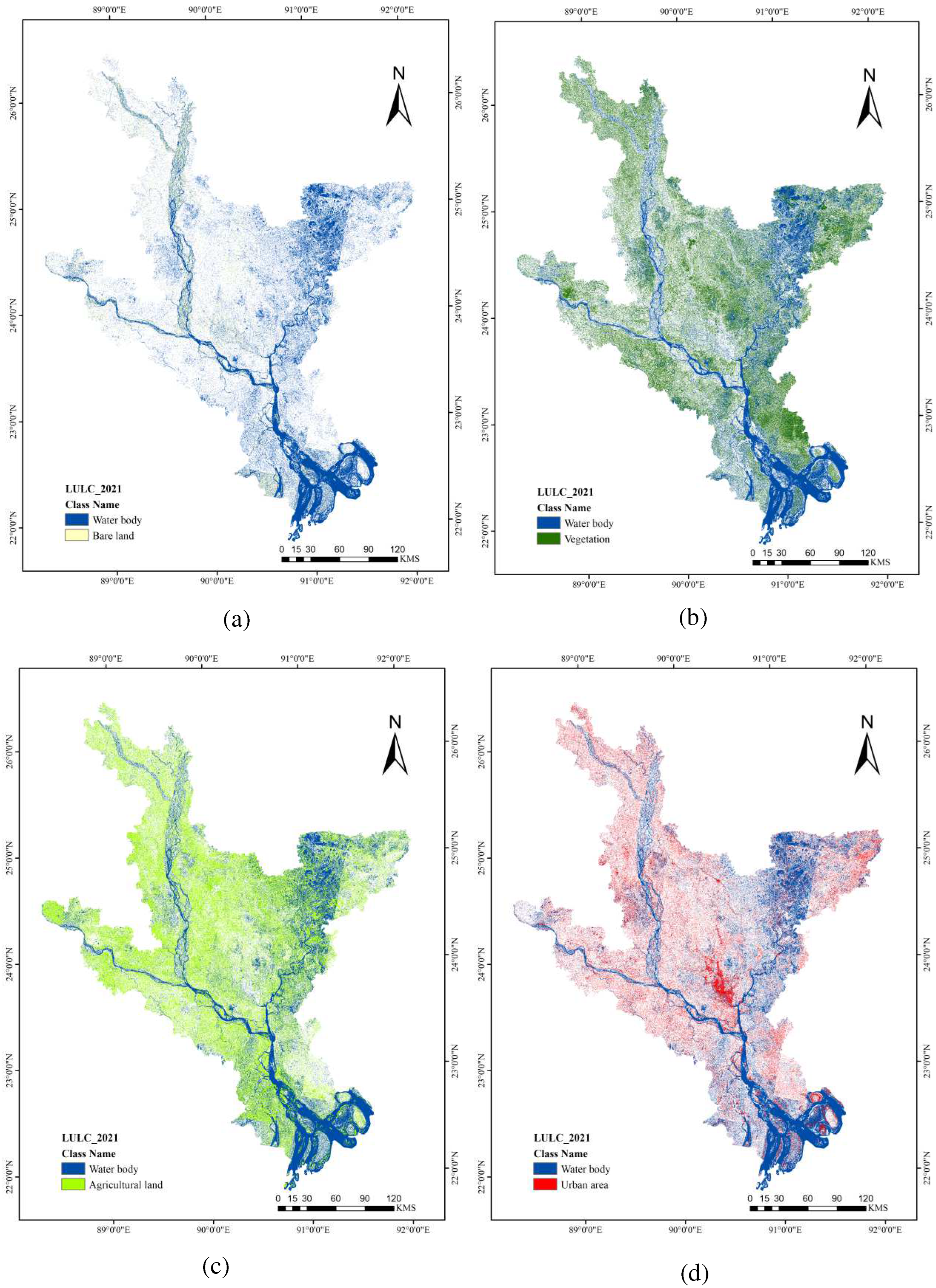
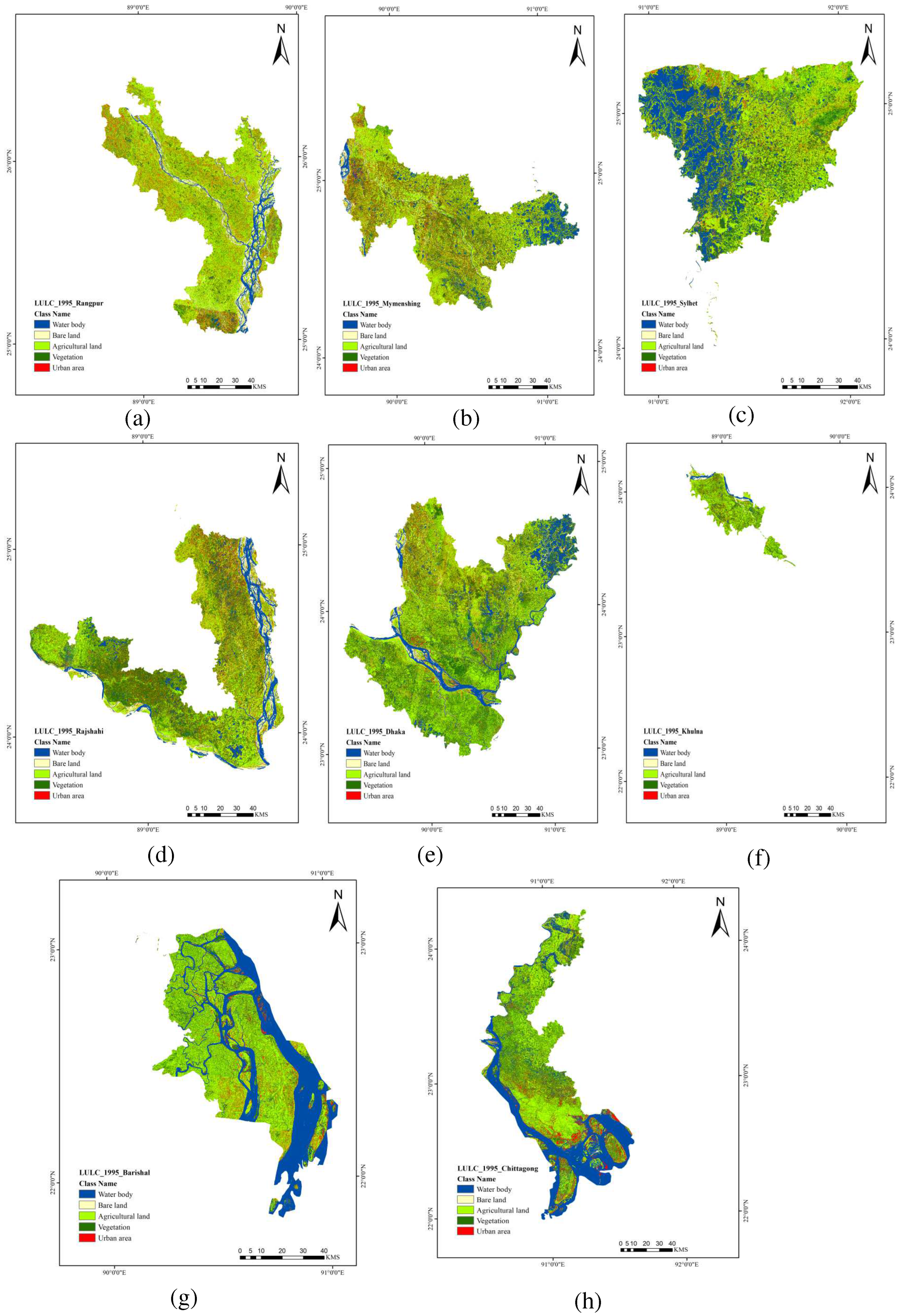

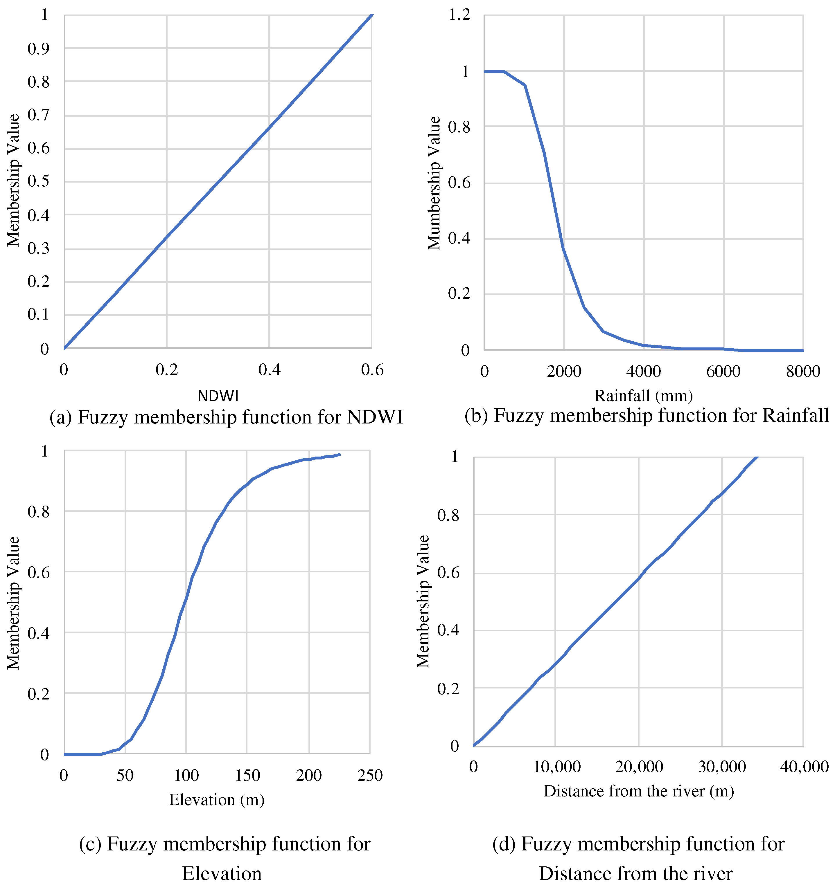
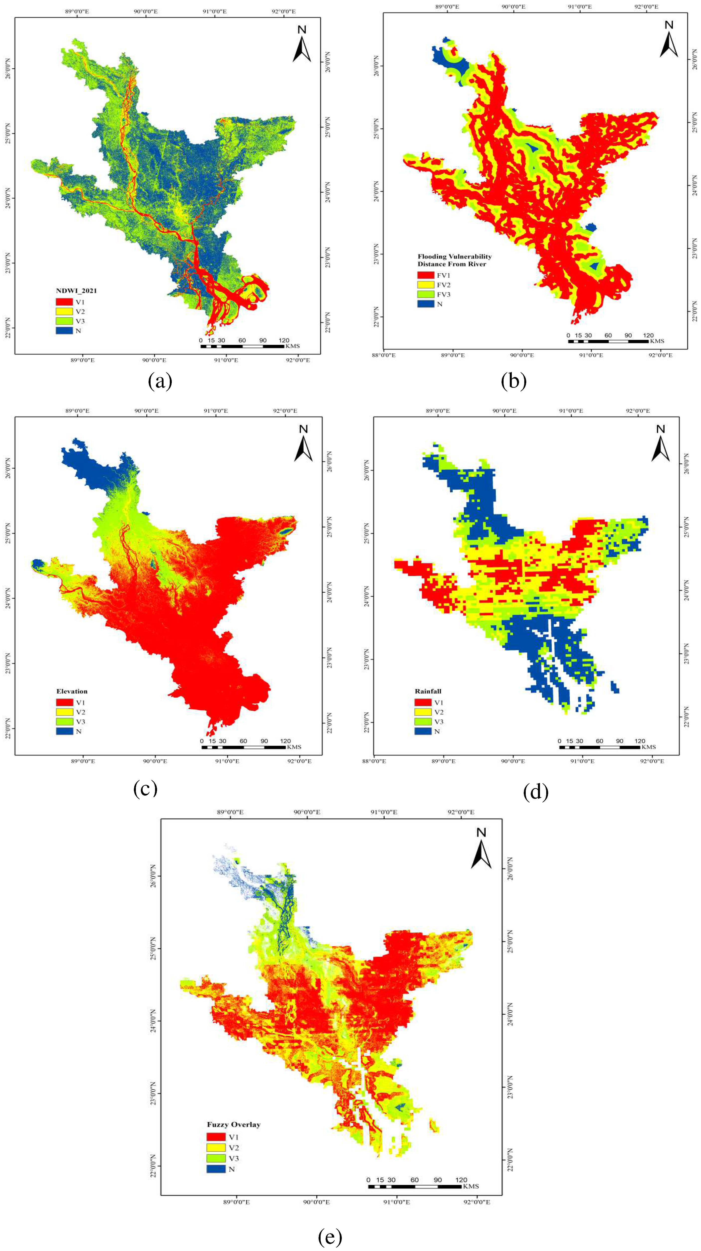


| Source | Type of Data |
|---|---|
| Bangladesh Bureau of Statistics (BBS) | Administrative area and river shape files. |
| USGS | Landsat-8 OLI satellite images with bands (1 to 7) of 2021, 30 m spatial resolution. |
| USGS | Landsat-5 satellite images of 1990, including all bands (b1 to b7) with 30 m spatial resolution. |
| SRTM (USGS) | Digital Elevation Model (DEM) data |
| www.chrsdata.eng.uci.edu (accessed on 31 July 2022) | Precipitation data for the year of 2021. |
| LULC Classes | For the Year 1995 | For the Year 2021 | Changes | ||
|---|---|---|---|---|---|
| Area (km2) | Area (%) | Area (km2) | Area (%) | Area (%) | |
| Water body | 12,277 | 19.02 | 14630 | 22.66 | 3.65 |
| Bare land | 1908 | 2.96 | 3314 | 5.13 | 2.18 |
| Vegetation | 14,848 | 23.00 | 16,983 | 26.31 | 3.31 |
| Agricultural land | 28,667 | 44.41 | 21,129 | 32.73 | −11.68 |
| Urban area | 6855 | 10.62 | 8499 | 13.17 | 2.55 |
| LULC Classes | Administrative Division | For the Year 1995 | For the Year 2021 | Changes | ||
|---|---|---|---|---|---|---|
| Area (%) | Area (km2) | Area (%) | Area (km2) | Area (%) | ||
| Water body | Rangpur | 9.07 | 668 | 11.28 | 831 | 2.21 |
| Rajshahi | 13.52 | 1099 | 14.61 | 1188 | 1.09 | |
| Dhaka | 15.03 | 2723 | 15.91 | 2881 | 0.87 | |
| Khulna | 7.45 | 129 | 10.19 | 177 | 2.74 | |
| Mymensingh | 13.15 | 991 | 14.41 | 1086 | 1.26 | |
| Sylhet | 25.20 | 1624 | 27.72 | 1786 | 2.53 | |
| Barishal | 35.37 | 1708 | 41.83 | 2020 | 6.46 | |
| Chittagong | 32.62 | 3368 | 38.04 | 3893 | 5.42 | |
| Bare land | Rangpur | 8.21 | 605 | 9.98 | 736 | 1.77 |
| Rajshahi | 5.80 | 471 | 7.21 | 586 | 1.41 | |
| Dhaka | 2.28 | 413 | 4.35 | 788 | 2.07 | |
| Khulna | 4.62 | 80 | 7.99 | 139 | 3.37 | |
| Mymensingh | 3.32 | 250 | 3.61 | 272 | 0.29 | |
| Sylhet | 0.40 | 26 | 0.98 | 63 | 0.58 | |
| Barishal | 0.16 | 8 | 7.50 | 362 | 7.33 | |
| Chittagong | 0.38 | 39 | 2.20 | 225 | 1.82 | |
| Vegetation | Rangpur | 11.96 | 881 | 31.39 | 2313 | 19.44 |
| Rajshahi | 27.56 | 2241 | 23.87 | 1941 | −3.69 | |
| Dhaka | 28.82 | 5219 | 28.64 | 5188 | −0.18 | |
| Khulna | 29.65 | 514 | 27.43 | 476 | −2.22 | |
| Mymensingh | 19.80 | 1492 | 26.61 | 2005 | 6.81 | |
| Sylhet | 23.18 | 1493 | 29.34 | 1891 | 6.17 | |
| Barishal | 16.42 | 793 | 11.33 | 547 | −5.10 | |
| Chittagong | 21.35 | 2205 | 25.17 | 2576 | 3.82 | |
| Agricultural land | Rangpur | 56.99 | 4199 | 33.69 | 2483 | −23.30 |
| Rajshahi | 39.62 | 3222 | 39.91 | 3246 | 0.29 | |
| Dhaka | 44.13 | 7993 | 37.16 | 6731 | −6.97 | |
| Khulna | 50.39 | 874 | 41.77 | 724 | −8.62 | |
| Mymensingh | 48.24 | 3635 | 43.82 | 3302 | −4.42 | |
| Sylhet | 42.76 | 2756 | 27.76 | 1789 | −15.01 | |
| Barishal | 42.18 | 2037 | 33.36 | 1611 | −8.82 | |
| Chittagong | 37.65 | 3888 | 24.41 | 2499 | −13.24 | |
| Urban area | Rangpur | 13.77 | 1015 | 13.65 | 1006 | −0.12 |
| Rajshahi | 13.51 | 1099 | 14.40 | 1171 | 0.89 | |
| Dhaka | 9.73 | 1763 | 13.94 | 2524 | 4.20 | |
| Khulna | 7.89 | 137 | 12.62 | 219 | 4.73 | |
| Mymensingh | 15.48 | 1167 | 11.55 | 870 | −3.94 | |
| Sylhet | 8.47 | 546 | 14.20 | 915 | 5.73 | |
| Barishal | 5.86 | 283 | 5.99 | 289 | 0.13 | |
| Chittagong | 8.00 | 826 | 10.19 | 1043 | 2.19 | |
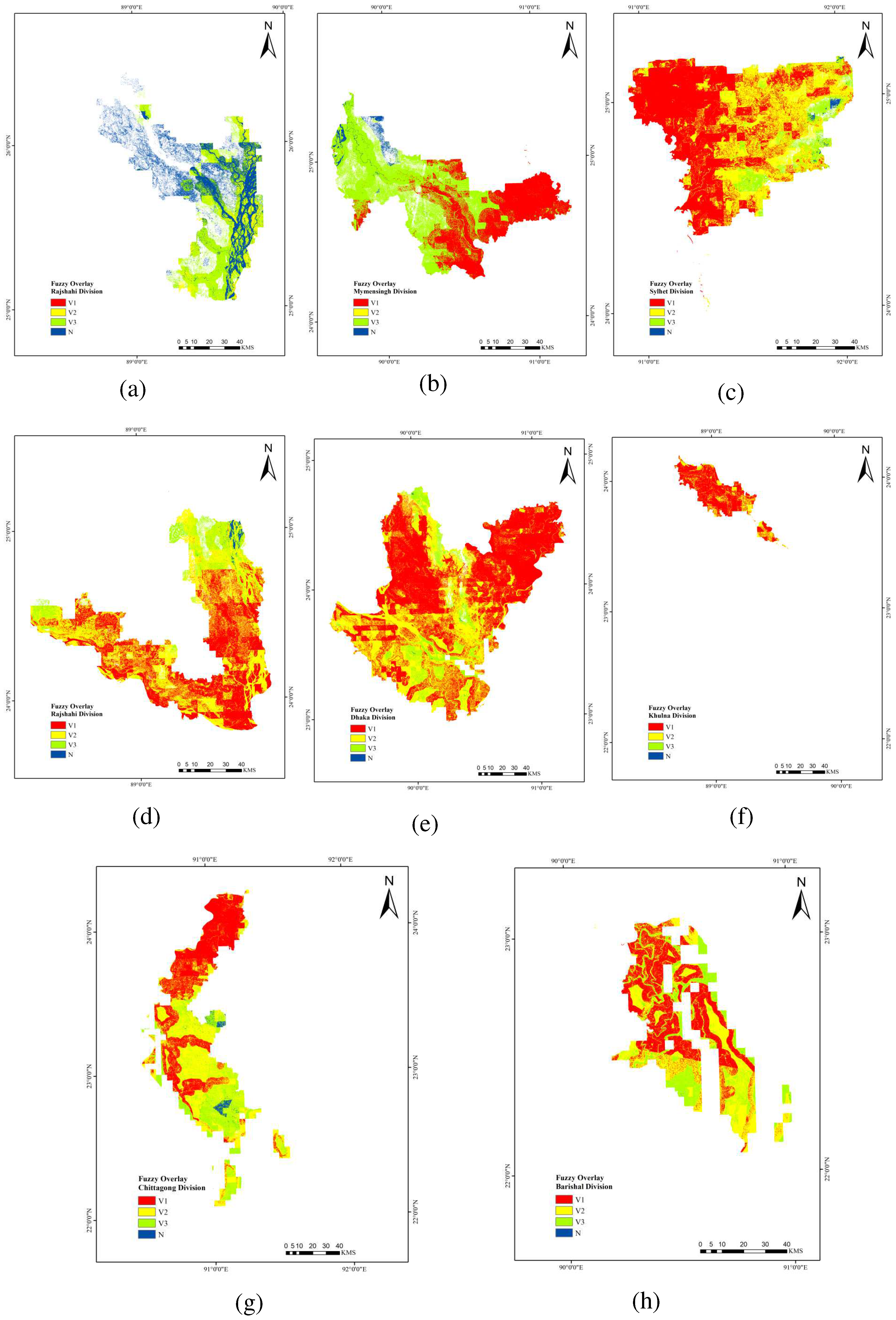
| Vulnerability Classes | Area (km2) | Area (%) |
|---|---|---|
| V1 (highly vulnerable area for agricultural land use) | 23,518 | 44.34 |
| V2 (moderately vulnerable area for agricultural land use) | 20,023 | 37.75 |
| V3 (Marginally vulnerable area for agricultural land use) | 7385 | 13.92 |
| N (non-vulnerable area for agricultural land use) | 2111 | 3.98 |
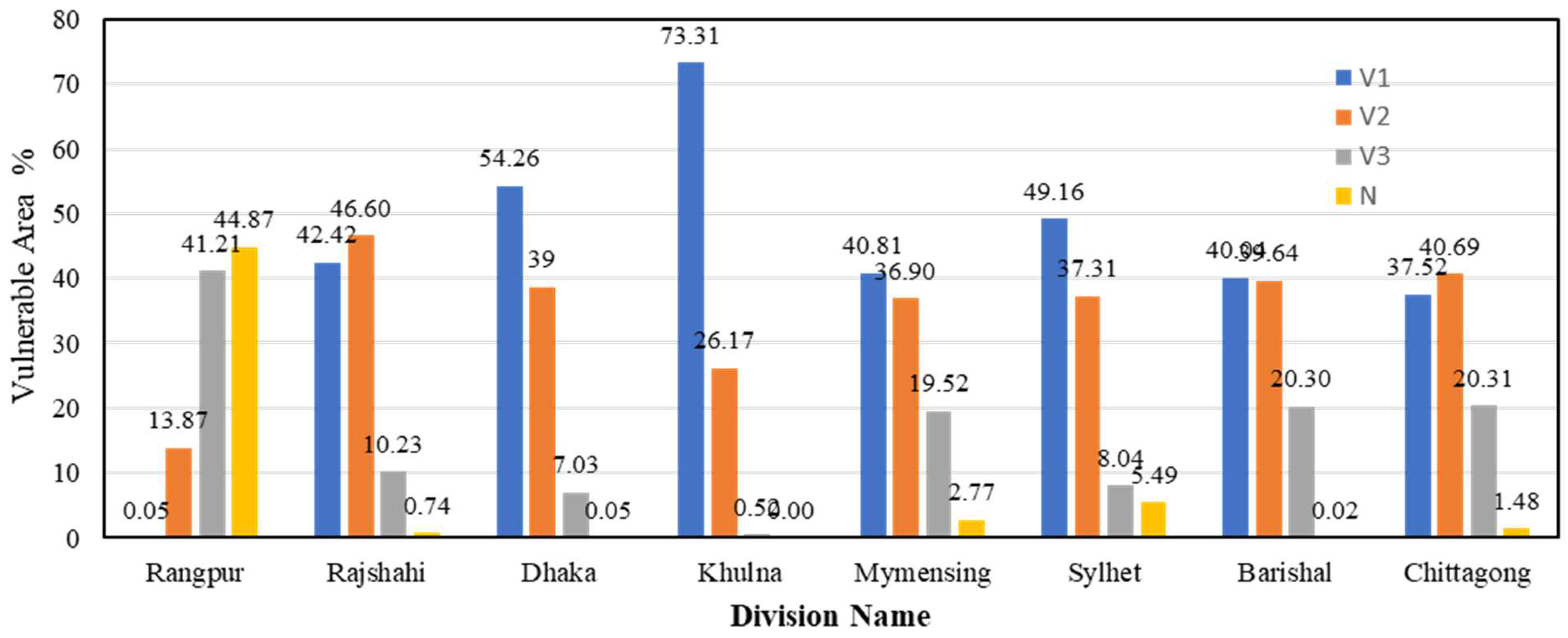
| Vulnerability Classes | Administrative Divisions | Area (%) | Area (km2) |
|---|---|---|---|
| V1 | Rangpur | 0.05 | 2 |
| Rajshahi | 42.42 | 3190 | |
| Dhaka | 54.26 | 9497 | |
| Khulna | 73.31 | 1217 | |
| Mymensingh | 40.81 | 2673 | |
| Sylhet | 49.16 | 3144 | |
| Barishal | 40.04 | 1149 | |
| Chittagong | 37.52 | 2649 | |
| V2 | Rangpur | 13.87 | 533 |
| Rajshahi | 46.60 | 3504 | |
| Dhaka | 38.66 | 6766 | |
| Khulna | 26.17 | 434 | |
| Mymensingh | 36.90 | 2418 | |
| Sylhet | 37.31 | 2385 | |
| Barishal | 39.64 | 1137 | |
| Chittagong | 40.69 | 2873 | |
| V3 | Rangpur | 41.21 | 1584 |
| Rajshahi | 10.23 | 769 | |
| Dhaka | 7.03 | 1231 | |
| Khulna | 0.52 | 9 | |
| Mymensingh | 19.52 | 1279 | |
| Sylhet | 8.04 | 5134 | |
| Barishal | 20.30 | 582 | |
| Chittagong | 20.31 | 1434 | |
| N | Rangpur | 44.87 | 1724 |
| Rajshahi | 0.74 | 56 | |
| Dhaka | 0.05 | 8 | |
| Khulna | 0.00 | 0 | |
| Mymensingh | 2.77 | 181 | |
| Sylhet | 5.49 | 351 | |
| Barishal | 0.02 | 1 | |
| Chittagong | 1.48 | 104 |
Publisher’s Note: MDPI stays neutral with regard to jurisdictional claims in published maps and institutional affiliations. |
© 2022 by the authors. Licensee MDPI, Basel, Switzerland. This article is an open access article distributed under the terms and conditions of the Creative Commons Attribution (CC BY) license (https://creativecommons.org/licenses/by/4.0/).
Share and Cite
Alam, K.F.; Ahamed, T. Assessment of Land Use Land Cover Changes for Predicting Vulnerable Agricultural Lands in River Basins of Bangladesh Using Remote Sensing and a Fuzzy Expert System. Remote Sens. 2022, 14, 5582. https://doi.org/10.3390/rs14215582
Alam KF, Ahamed T. Assessment of Land Use Land Cover Changes for Predicting Vulnerable Agricultural Lands in River Basins of Bangladesh Using Remote Sensing and a Fuzzy Expert System. Remote Sensing. 2022; 14(21):5582. https://doi.org/10.3390/rs14215582
Chicago/Turabian StyleAlam, Kazi Faiz, and Tofael Ahamed. 2022. "Assessment of Land Use Land Cover Changes for Predicting Vulnerable Agricultural Lands in River Basins of Bangladesh Using Remote Sensing and a Fuzzy Expert System" Remote Sensing 14, no. 21: 5582. https://doi.org/10.3390/rs14215582
APA StyleAlam, K. F., & Ahamed, T. (2022). Assessment of Land Use Land Cover Changes for Predicting Vulnerable Agricultural Lands in River Basins of Bangladesh Using Remote Sensing and a Fuzzy Expert System. Remote Sensing, 14(21), 5582. https://doi.org/10.3390/rs14215582


