


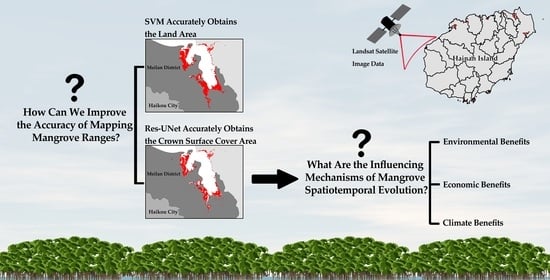
Research on the Spatiotemporal Evolution of Mangrove Forests in the Hainan Island from 1991 to 2021 Based on SVM and Res-UNet Algorithms

 ,
, 
Abstract
1. Introduction
2. Materials and Methods
2.1. Materials
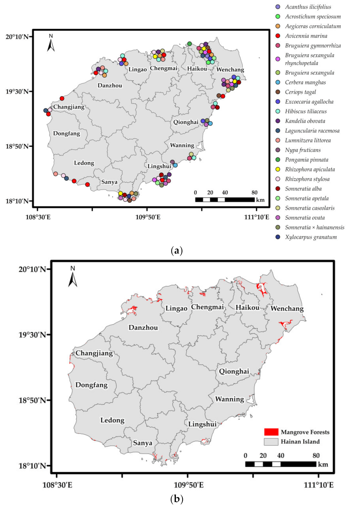
2.1.1. Study Area
2.1.2. Ground Survey Data Sources
2.1.3. Landsat Data Sources and Preprocessing
2.1.4. Population, Economy, and Climate Data Sources
2.2. Methods
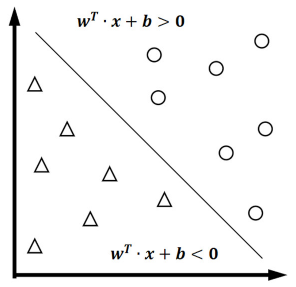
2.2.1. Support Vector Machine
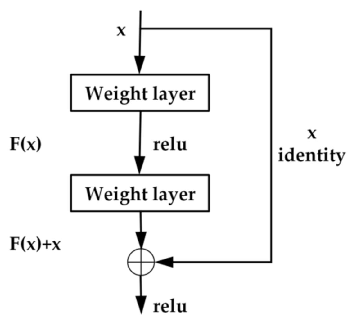
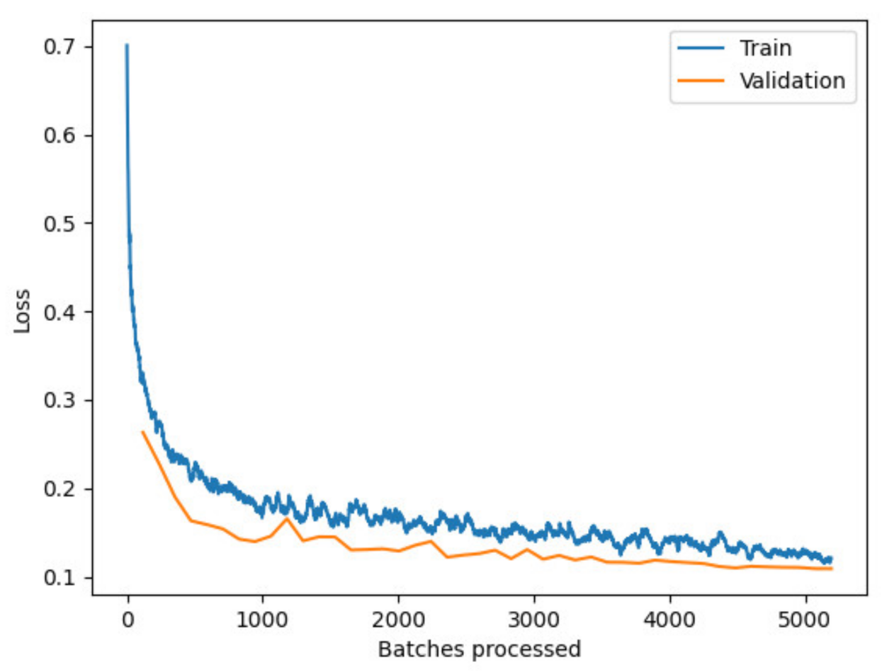
2.2.2. Res-UNet
2.2.3. Accuracy Assessment
2.2.4. Dynamic Change and Landscape Pattern Analysis
2.2.5. Statistical Analysis of Driving Forces
3. Results
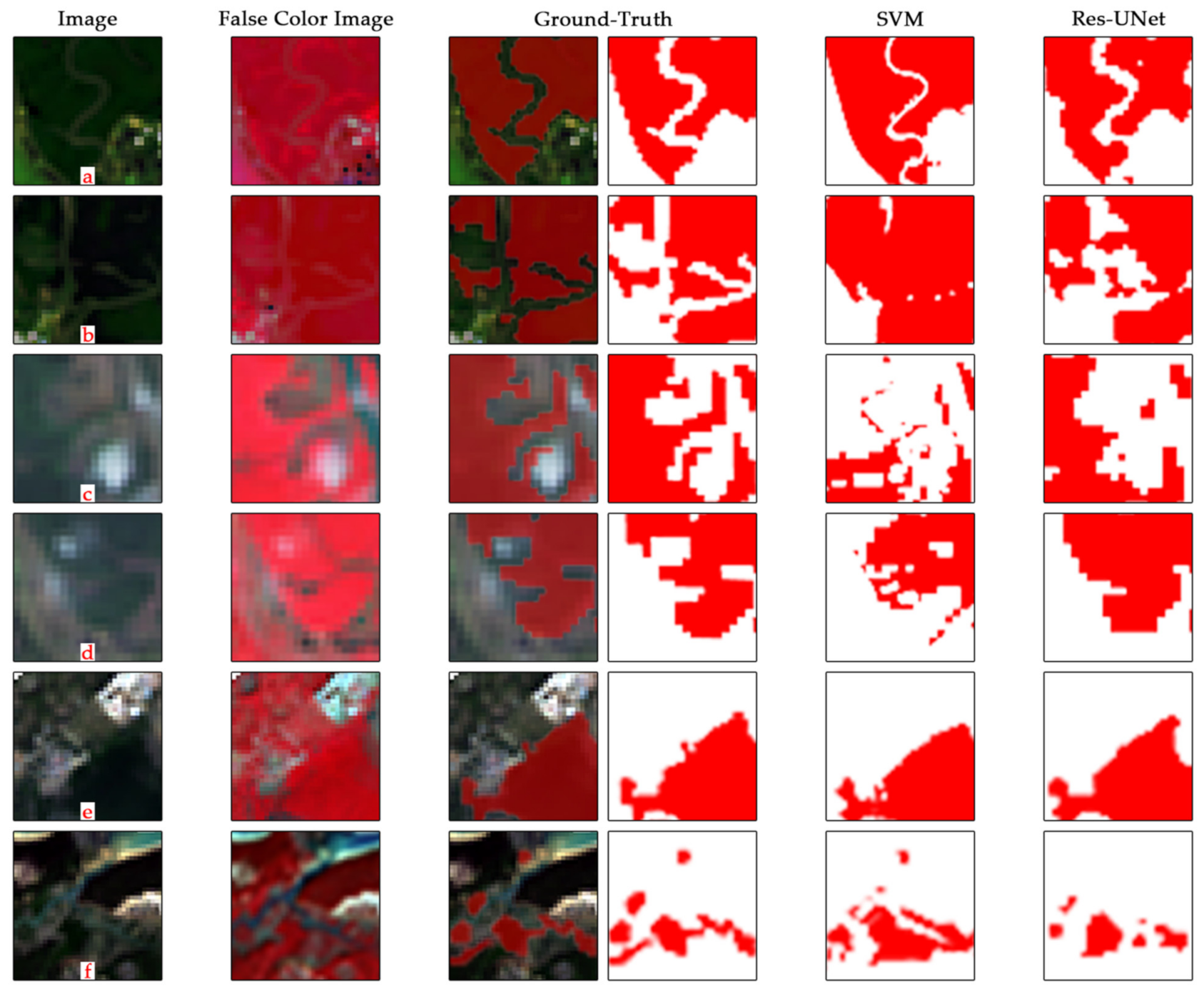
3.1. Analysis of the Classification Results
3.1.1. Classification Results of SVM Machine Learning
3.1.2. Classification Results of Res-UNet Deep Learning
3.1.3. Comparison of Mapping Results between SVM Machine Learning and Res-UNet Deep Learning
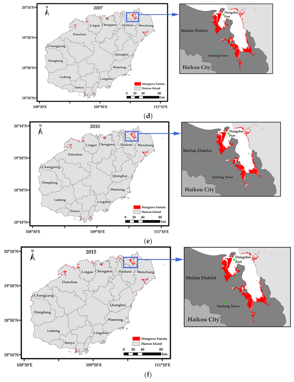
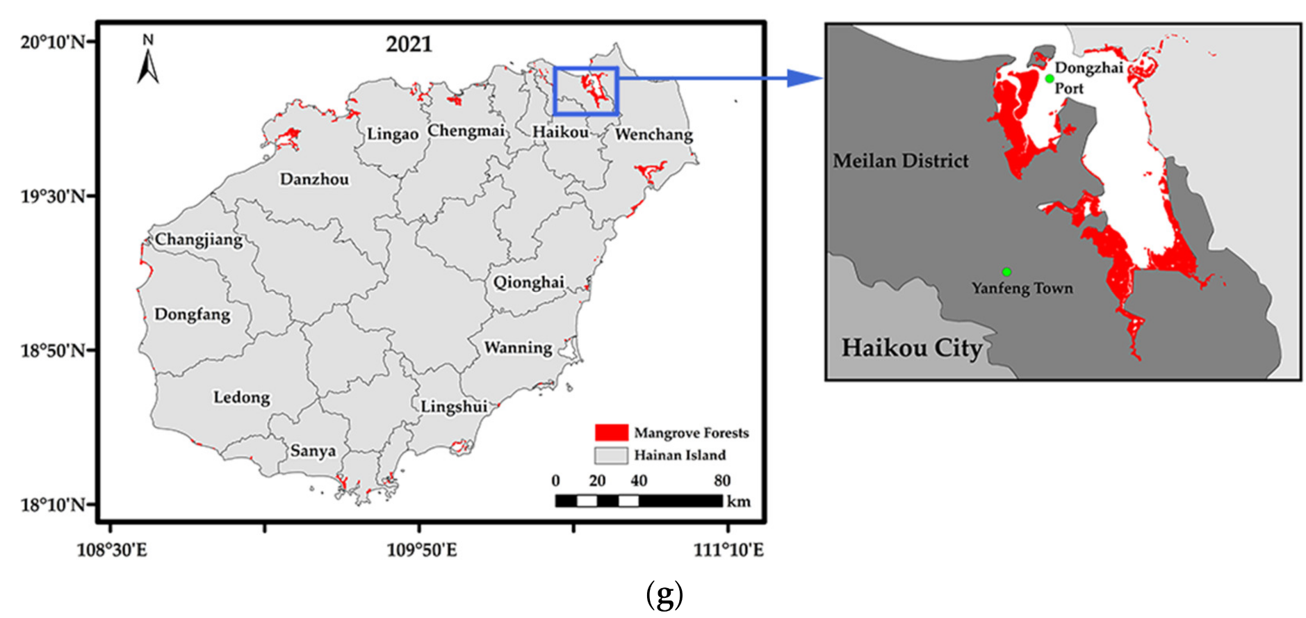
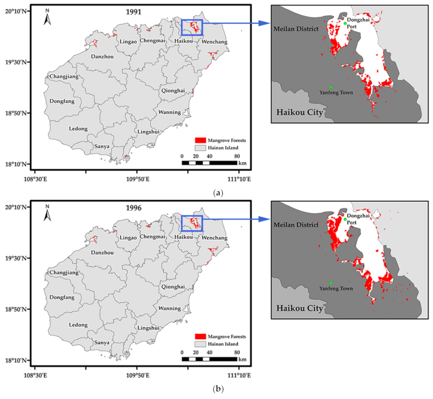
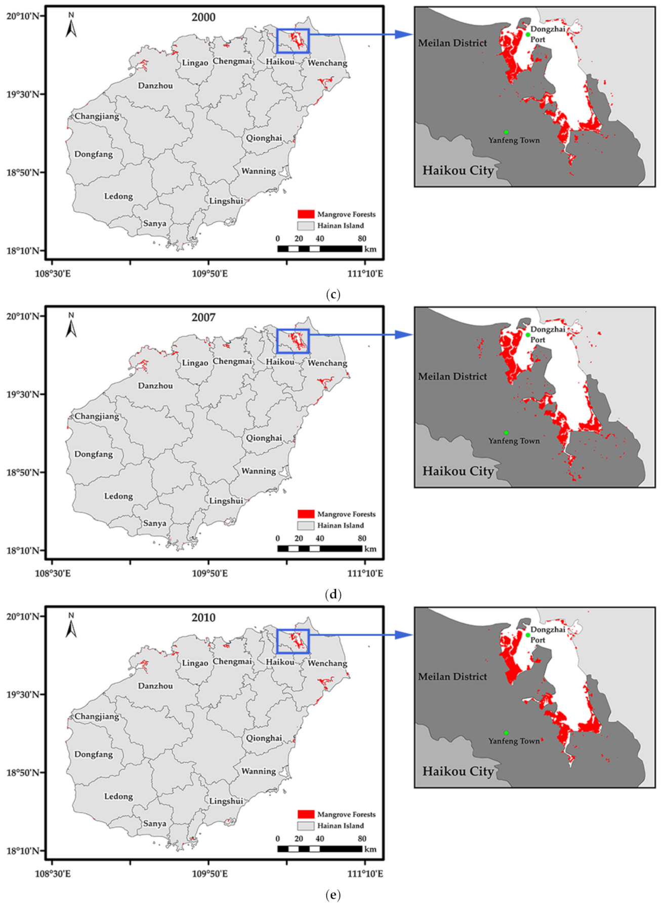
3.2. Analysis of Spatiotemporal Changes of Mangrove Forests in the Hainan Island
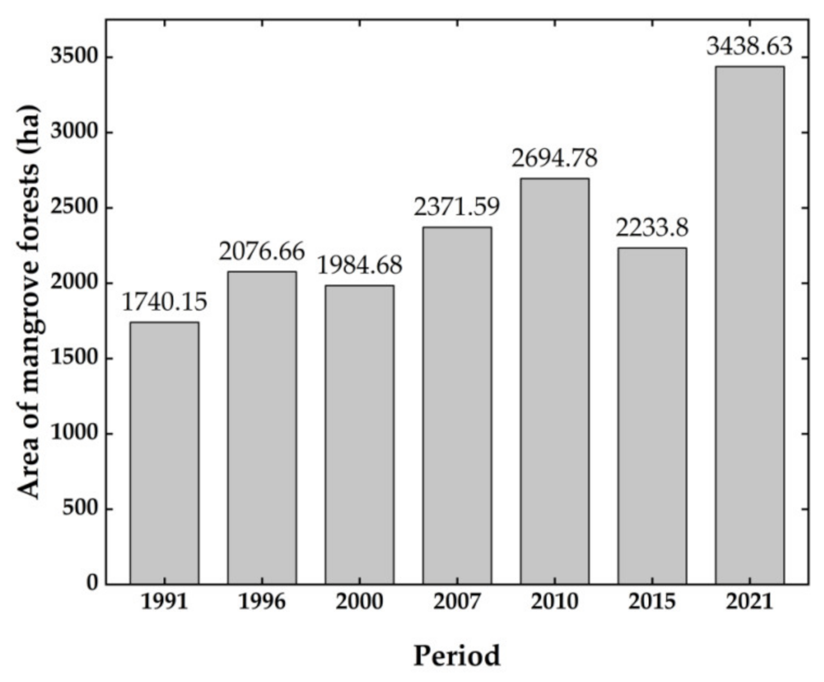
3.2.1. Change in Mangrove Forest Crown Surface Cover Area during 1991–2021
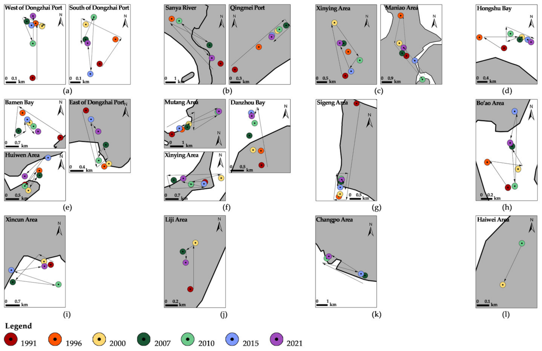
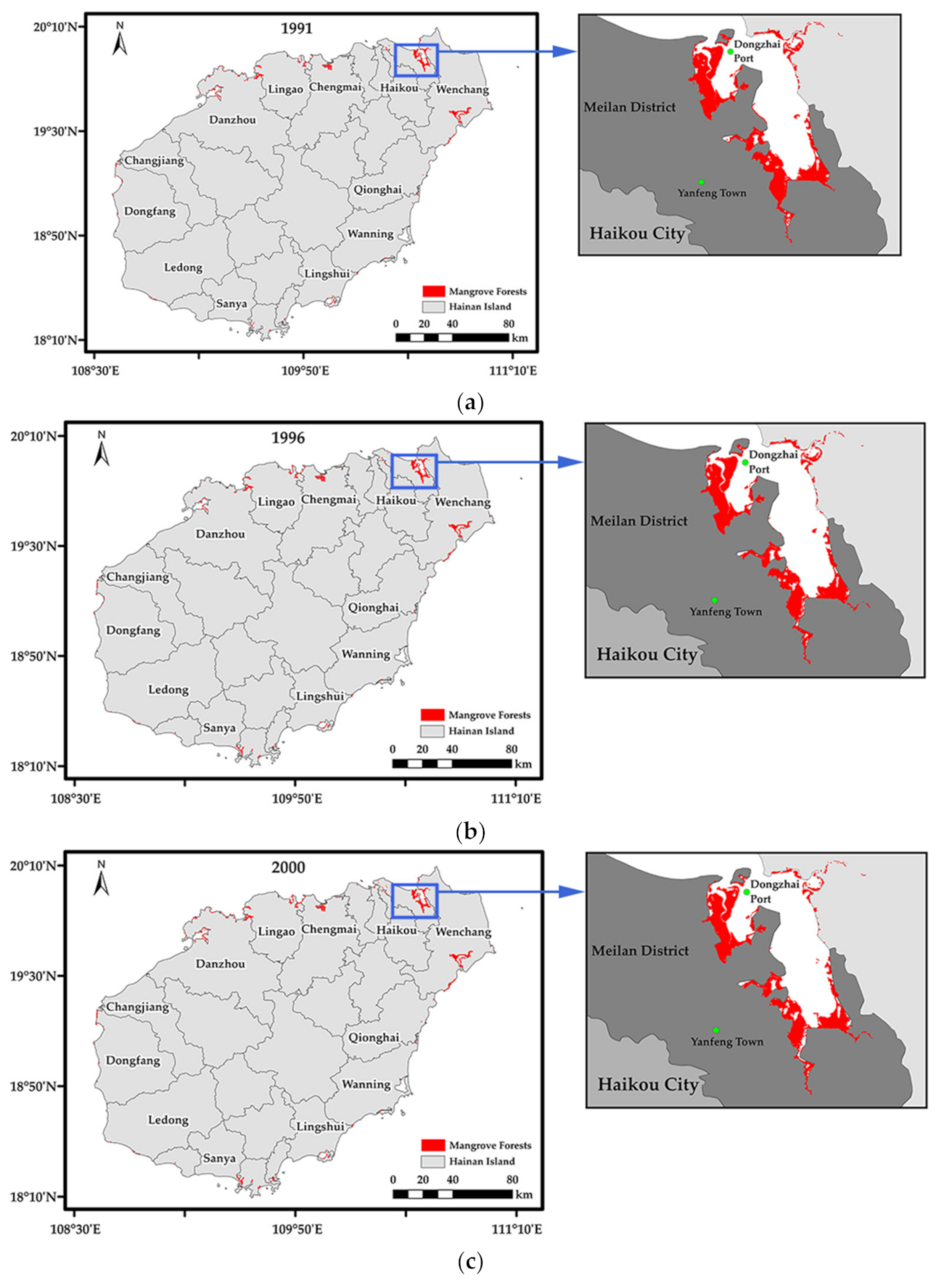
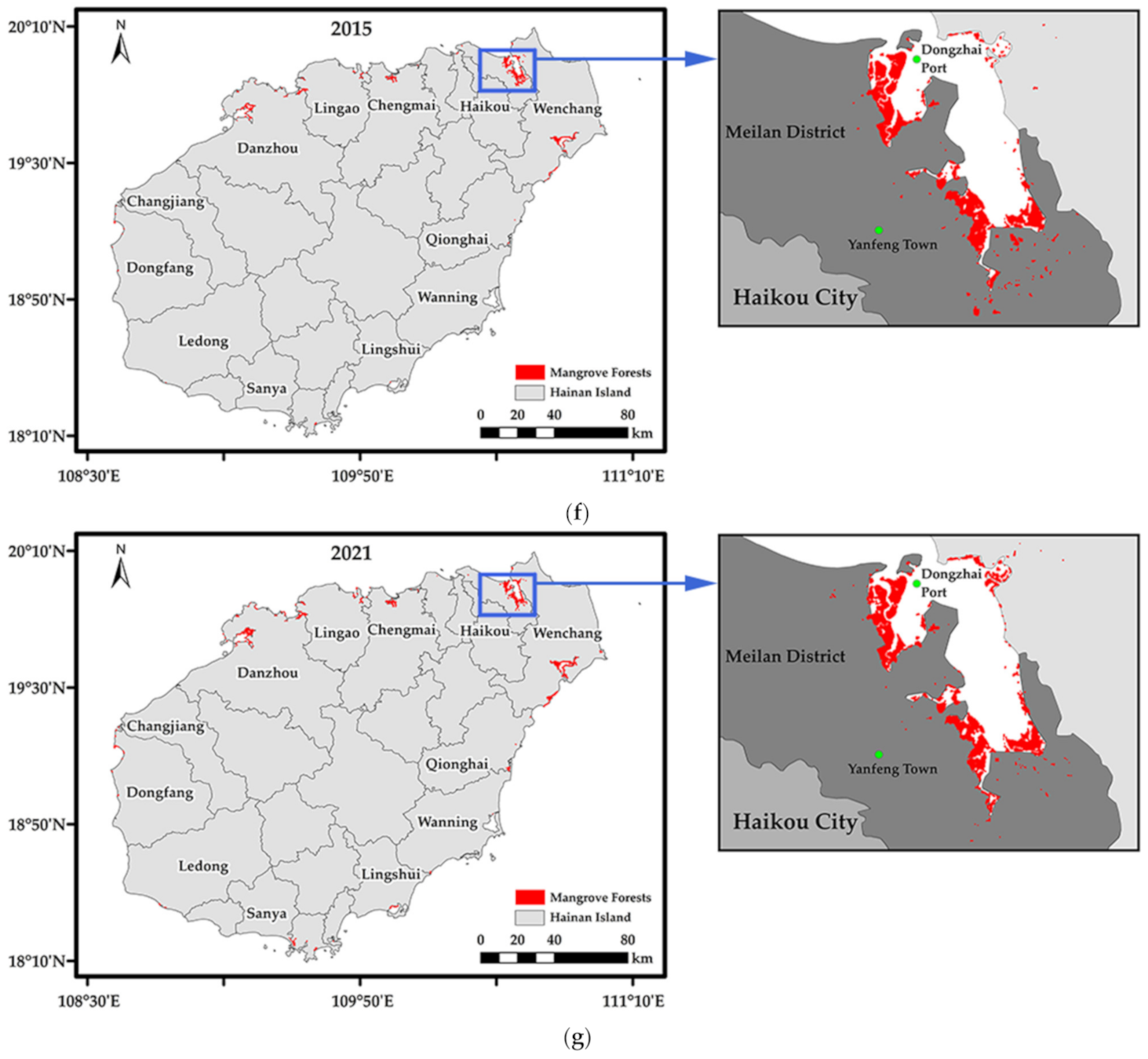
3.2.2. Spatial Distribution and Changes in Mangrove Forests during 1991–2021
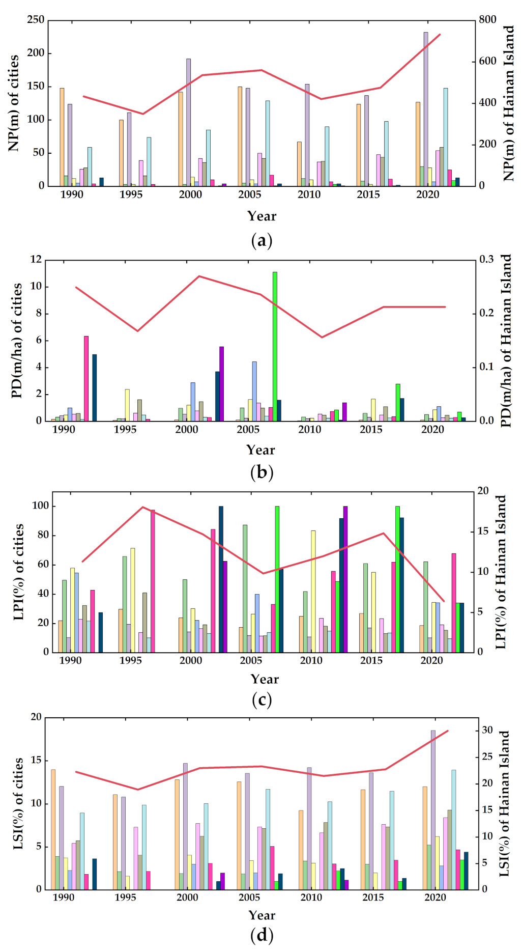
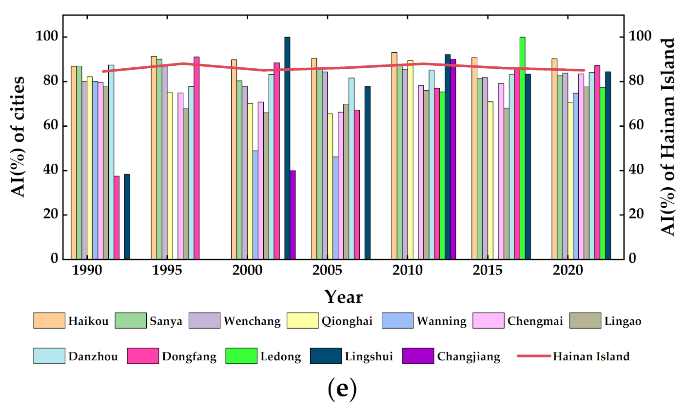
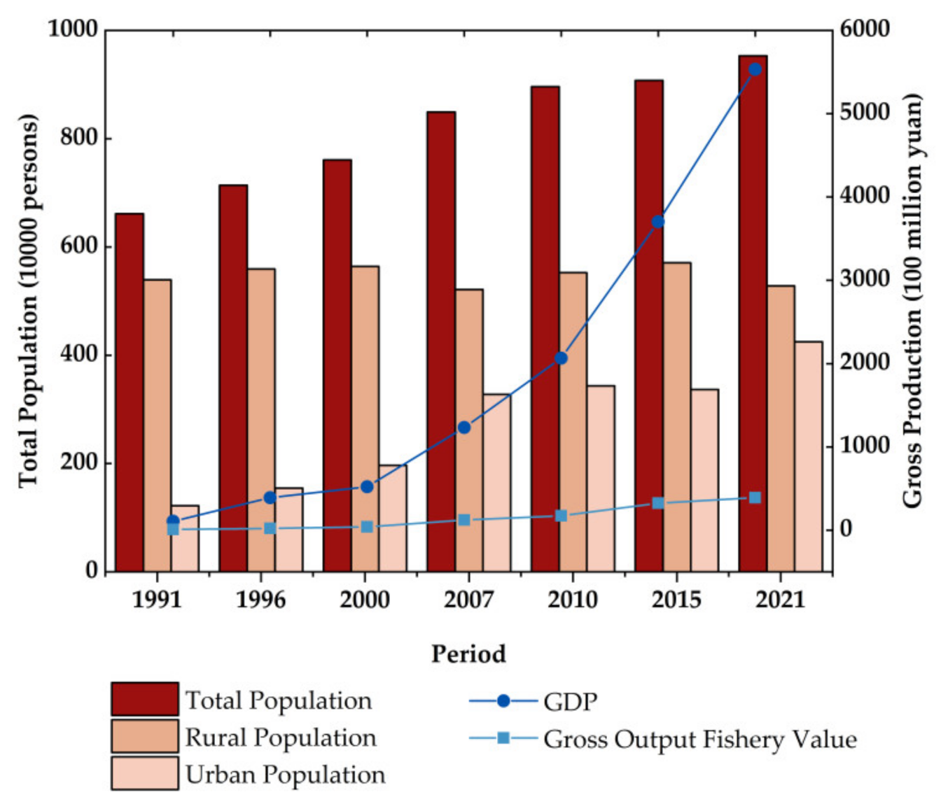
3.2.3. Influential Mechanisms of Mangrove Forest Landscape Evolution
4. Discussion
4.1. Comparative Analysis of Mangrove Classification Methods
4.2. Spatiotemporal Evolution of Mangrove Forests in the Hainan Island
5. Conclusions
Author Contributions
Funding
Data Availability Statement
Acknowledgments
Conflicts of Interest
Appendix A
Appendix A.1

| Distribution of Dominant Mangrove Forests Tree Species in Hainan Island, 2021 | ||
|---|---|---|
| City/County | Tree Species | |
| Haikou | Acanthus ilicifolius L. | Excoecaria agallocha Linn. |
| Acrostichum speciosum Will. | Hibiscus tiliaceus Linn. | |
| Aegiceras corniculatum (Linn.) Blanco | Kandelia obovata Sheue, Liu et Yong | |
| Avicennia marina (Forsk) Vierh. | Laguncularia racemosa Gaertn. f. | |
| Bruguiera gymnorrhiza (Linn.) Sav. | Pongamia pinnata (Linn.) Pierre | |
| Bruguiera sexangula (Lour.) Poir. | Rhizophora apiculata Blume | |
| Bruguiera sexangula (Lour.) Poir. var. rhynchopetala Ko | Rhizophora stylosa Griff | |
| Ceriops tagal (Perr.) C. B. Rob. | Sonneratia apetala Buch. -Ham. | |
| Sanya | Aegiceras corniculatum (Linn.) Blanco | Rhizophora stylosa Griff. |
| Avicennia marina (Forsk) Vierh. | Sonneratia × hainanensis Ko, E. Y. Chen et W. Y. Chen | |
| Ceriops tagal (Perr.) C. B. Rob. | Sonneratia alba J. Smith | |
| Lumnitzera racemosa Willd | Sonneratia ovata Backer | |
| Rhizophora apiculata Blume | Xylocarpus granatum J. Koenig | |
| Wenchang | Avicennia marina (Forsk) Vierh. | Lumnitzera littorea (Jack) Voigt |
| Bruguiera gymnorrhiza (Linn.) Sav. | Rhizophora apiculata Blume | |
| Bruguiera sexangula (Lour.) Poir. var. rhynchopetala Ko | Rhizophora stylosa Griff. | |
| Ceriops tagal (Perr.) C. B. Rob. | Sonneratia × hainanensis Ko, E. Y. Chen et W. Y. Chen | |
| Excoecaria agallocha Linn. | Sonneratia alba J. Smith | |
| Hibiscus tiliaceus Linn. | Sonneratia caseolaris (Linn.) Engl. | |
| Kandelia obovata Sheue, Liu et Yong | Sonneratia ovata Backer | |
| Laguncularia racemosa Gaertn. f. | ||
| Qionghai | Bruguiera gymnorrhiza (Linn.) Sav. | Sonneratia × hainanensis Ko, E. Y. Chen et W. Y. Chen |
| Cerbera manghas L. | Sonneratia alba J. Smith | |
| Hibiscus tiliaceus Linn. | Sonneratia ovata Backer | |
| Wanning | Bruguiera gymnorrhiza (Linn.) Sav. | Hibiscus tiliaceus Linn. |
| Cerbera manghas L. | Nypa fruticans Wurmb. | |
| Excoecaria agallocha Linn. | Sonneratia caseolaris (Linn.) Engl. | |
| Chengmai | Aegiceras corniculatum (Linn.) Blanco | Lumnitzera littorea (Jack) Voigt |
| Avicennia marina (Forsk) Vierh. | Rhizophora apiculata Blume | |
| Hibiscus tiliaceus Linn. | Rhizophora stylosa Griff. | |
| Kandelia obovata Sheue, Liu et Yong | Sonneratia caseolaris (Linn.) Engl. | |
| Lingao | Aegiceras corniculatum (Linn.) Blanco | Hibiscus tiliaceus Linn. |
| Avicennia marina (Forsk) Vierh. | Rhizophora stylosa Griff. | |
| Excoecaria agallocha Linn. | ||
| Danzhou | Aegiceras corniculatum (Linn.) Blanco | Kandelia obovata Sheue, Liu et Yong |
| Avicennia marina (Forsk) Vierh. | Lumnitzera littorea (Jack) Voigt | |
| Hibiscus tiliaceus Linn. | Rhizophora stylosa Griff. | |
| Dongfang | Avicennia marina (Forsk) Vierh. | Laguncularia racemosa Gaertn. f. |
| Ledong | Rhizophora stylosa Griff. | Avicennia marina (Forsk) Vierh. |
| Lumnitzera littorea (Jack) Voigt | Laguncularia racemosa Gaertn. f. | |
| Lingshui | Avicennia marina (Forsk) Vierh. | Rhizophora stylosa Griff. |
| Bruguiera gymnorrhiza (Linn.) Sav. | Sonneratia × hainanensis Ko, E. Y. Chen et W. Y. Chen | |
| Bruguiera sexangula (Lour.) Poir. var. rhynchopetala Ko | Sonneratia alba J. Smith | |
| Kandelia obovata Sheue, Liu et Yong | Sonneratia apetala Buch. -Ham. | |
| Laguncularia racemosa Gaertn. f. | Sonneratia ovata Backer | |
| Changjiang | Avicennia marina (Forsk) Vierh. | Rhizophora stylosa Griff |
Appendix A.2


References
- Tomlinson, P.B. The Botany of Mangroves; Cambridge University Press: Cambridge, MA, USA, 2016. [Google Scholar]
- Simard, M.; Fatoyinbo, L.; Smetanka, C.; Rivera-Monroy, V.H.; Castañeda-Moya, E.; Thomas, N.; Van der Stocken, T. Mangrove canopy height globally related to precipitation, temperature and cyclone frequency. Nat. Geosci. 2019, 12, 40–45. [Google Scholar] [CrossRef]
- Getzner, M.; Islam, M.S. Ecosystem services of mangrove forests: Results of a meta-analysis of economic values. Int. J. Environ. Res. Public Health 2020, 17, 5830. [Google Scholar] [CrossRef] [PubMed]
- Donato, D.C.; Kauffman, J.B.; Murdiyarso, D.; Kurnianto, S.; Stidham, M.; Kanninen, M. Mangroves among the most carbon-rich forests in the tropics. Nat. Geosci. 2011, 4, 293–297. [Google Scholar] [CrossRef]
- Lee, S.Y.; Primavera, J.H.; Dahdouh-Guebas, F.; McKee, K.; Bosire, J.O.; Cannicci, S.; Diele, K.; Fromard, F.; Koedam, N.; Marchand, C. Ecological role and services of tropical mangrove ecosystems: A reassessment. Glob. Ecol. Biogeogr. 2014, 23, 726–743. [Google Scholar] [CrossRef]
- Goldberg, L.; Lagomasino, D.; Thomas, N.; Fatoyinbo, T. Global declines in human-driven mangrove loss. Glob. Chang. Biol. 2020, 26, 5844–5855. [Google Scholar] [CrossRef]
- Friess, D.A.; Rogers, K.; Lovelock, C.E.; Krauss, K.W.; Hamilton, S.E.; Lee, S.Y.; Lucas, R.; Primavera, J.; Rajkaran, A.; Shi, S. The state of the world’s mangrove forests: Past, present, and future. Annu. Rev. Environ. Resour. 2019, 44, 89–115. [Google Scholar] [CrossRef]
- Murray, N.J.; Phinn, S.R.; DeWitt, M.; Ferrari, R.; Johnston, R.; Lyons, M.B.; Clinton, N.; Thau, D.; Fuller, R.A. The global distribution and trajectory of tidal flats. Nature 2019, 565, 222–225. [Google Scholar] [CrossRef]
- Wang, L.; Jia, M.; Yin, D.; Tian, J. A review of remote sensing for mangrove forests: 1956–2018. Remote Sens. Environ. 2019, 231, 111223. [Google Scholar] [CrossRef]
- Liu, X.; Yang, X.; Zhang, T.; Wang, Z.; Zhang, J.; Liu, Y.; Liu, B. Remote sensing based conservation effectiveness evaluation of mangrove reserves in china. Remote Sens. 2022, 14, 1386. [Google Scholar] [CrossRef]
- Purnamasayangsukasih, P.R.; Norizah, K.; Ismail, A.A.; Shamsudin, I. A review of uses of satellite imagery in monitoring mangrove forests. Proceeding of 8th IGRSM International Conference and Exhibition on Geospatial & Remote Sensing (IGRSM 2016), Kuala Lumpur, Malaysia, 13–14 April 2016; 37, p. 012034. [Google Scholar] [CrossRef]
- Hauser, L.T.; Vu, G.N.; Nguyen, B.A.; Dade, E.; Nguyen, H.M.; Nguyen, T.T.Q.; Le, T.Q.; Vu, L.H.; Tong, A.T.H.; Pham, H.V. Uncovering the spatio-temporal dynamics of land cover change and fragmentation of mangroves in the Ca Mau peninsula, Vietnam using multi-temporal SPOT satellite imagery (2004–2013). Appl. Geogr. 2017, 86, 197–207. [Google Scholar] [CrossRef]
- Proisy, C.; Viennois, G.; Sidik, F.; Andayani, A.; Enright, J.A.; Guitet, S.; Gusmawati, N.; Lemonnier, H.; Muthusankar, G.; Olagoke, A. Monitoring mangrove forests after aquaculture abandonment using time series of very high spatial resolution satellite images: A case study from the perancak estuary, bali, indonesia. Mar. Pollut. Bull. 2018, 131, 61–71. [Google Scholar] [CrossRef] [PubMed]
- Pham, T.D.; Xia, J.; Ha, N.T.; Bui, D.T.; Le, N.N.; Takeuchi, W. A review of remote sensing approaches for monitoring blue carbon ecosystems: Mangroves, seagrasses and salt marshes during 2010–2018. Sensors 2019, 19, 1933. [Google Scholar] [CrossRef] [PubMed]
- Gaw, L.Y.; Linkie, M.; Friess, D.A. Mangrove forest dynamics in tanintharyi, myanmar from 1989–2014, and the role of future economic and political developments. Singap. J. Trop. Geogr. 2018, 39, 224–243. [Google Scholar] [CrossRef]
- Hu, L.; Li, W.; Xu, B. The role of remote sensing on studying mangrove forest extent change. Int. J. Remote Sens. 2018, 39, 6440–6462. [Google Scholar] [CrossRef]
- Thakur, S.; Mondal, I.; Ghosh, P.; Das, P.; De, T. A review of the application of multispectral remote sensing in the study of mangrove ecosystems with special emphasis on image processing techniques. Spat. Inf. Res. 2020, 28, 39–51. [Google Scholar] [CrossRef]
- Buck, O.; Millán, V.E.G.; Klink, A.; Pakzad, K. Using information layers for mapping grassland habitat distribution at local to regional scales. Int. J. Appl. Earth Obs. Geoinf. 2015, 37, 83–89. [Google Scholar] [CrossRef]
- Hu, L.; Li, W.; Xu, B. Monitoring mangrove forest change in china from 1990 to 2015 using landsat-derived spectral-temporal variability metrics. Int. J. Appl. Earth Obs. Geoinf. 2018, 73, 88–98. [Google Scholar] [CrossRef]
- Abdi, A.M. Land cover and land use classification performance of machine learning algorithms in a boreal landscape using sentinel-2 data. GIScience Remote Sens. 2020, 57, 1–20. [Google Scholar] [CrossRef]
- Guo, Y.; Liao, J.; Shen, G. Mapping large-scale mangroves along the maritime silk road from 1990 to 2015 using a novel deep learning model and landsat data. Remote Sens. 2021, 13, 245. [Google Scholar] [CrossRef]
- Li, H.; Hu, B.; Li, Q.; Jing, L. Cnn-based individual tree species classification using high-resolution satellite imagery and airborne lidar data. Forests 2021, 12, 1697. [Google Scholar] [CrossRef]
- Zhang, Z.; Liu, Q.; Wang, Y. Road extraction by deep residual u-net. IEEE Geosci. Remote Sens. Lett. 2018, 15, 749–753. [Google Scholar] [CrossRef]
- Cao, K.; Zhang, X. An improved res-unet model for tree species classification using airborne high-resolution images. Remote Sens. 2020, 12, 1128. [Google Scholar] [CrossRef]
- Ibharim, N.; Mustapha, M.; Lihan, T.; Mazlan, A. Mapping mangrove changes in the matang mangrove forest using multi temporal satellite imageries. Ocean Coast. Manag. 2015, 114, 64–76. [Google Scholar] [CrossRef]
- Son, N.T.; Thanh, B.X.; Da, C.T. Monitoring mangrove forest changes from multi-temporal landsat data in can gio biosphere reserve, vietnam. Wetlands 2016, 36, 565–576. [Google Scholar] [CrossRef]
- Zhen, J.; Liao, J.; Shen, G. Mapping mangrove forests of dongzhaigang nature reserve in china using landsat 8 and radarsat-2 polarimetric sar data. Sensors 2018, 18, 4012. [Google Scholar] [CrossRef]
- Gilani, H.; Naz, H.I.; Arshad, M.; Nazim, K.; Akram, U.; Abrar, A.; Asif, M. Evaluating mangrove conservation and sustainability through spatiotemporal (1990–2020) mangrove cover change analysis in pakistan. Estuar. Coast. Shelf Sci. 2021, 249, 107128. [Google Scholar] [CrossRef]
- Giri, C.; Long, J.; Abbas, S.; Murali, R.M.; Qamer, F.M.; Pengra, B.; Thau, D. Distribution and dynamics of mangrove forests of south asia. J. Environ. Manag. 2015, 148, 101–111. [Google Scholar] [CrossRef]
- Liao, J.; Zhen, J.; Zhang, L.; Metternicht, G. Understanding dynamics of mangrove forest on protected areas of hainan island, china: 30 years of evidence from remote sensing. Sustainability 2019, 11, 5356. [Google Scholar] [CrossRef]
- Vapnik, V. The Nature of Statistical Learning Theory; Springer Science & Business Media: Berlin/Heidelberg, Germany, 1999. [Google Scholar]
- Maxwell, A.E.; Warner, T.A.; Fang, F. Implementation of machine-learning classification in remote sensing: An applied review. Int. J. Remote Sens. 2018, 39, 2784–2817. [Google Scholar] [CrossRef]
- Ronneberger, O.; Fischer, P.; Brox, T. In U-net: Convolutional networks for biomedical image segmentation. In Proceedings of the International Conference on Medical Image Computing and Computer-Assisted Intervention, Munich, Germany, 5–9 October 2015; Springer: Berlin/Heidelberg, Germany, 2015; pp. 234–241. Available online: https://lmb.informatik.uni-freiburg.de/people/ronneber/u-net/ (accessed on 1 September 2022).
- He, K.; Zhang, X.; Ren, S.; Sun, J. Deep residual learning for image recognition. In Proceedings of the IEEE Conference on Computer Vision and Pattern Recognition, Las Vegas, NV, USA, 27–30 June 2016; pp. 770–778. Available online: https://openaccess.thecvf.com/content_cvpr_2016/html/He_Deep_Residual_Learning_CVPR_2016_paper.html (accessed on 1 September 2022).
- Chaurasia, A.; Culurciello, E. Linknet: Exploiting encoder representations for efficient semantic segmentation. In Proceedings of the 2017 IEEE Visual Communications and Image Processing (VCIP), St. Petersburg, FL, USA, 10–13 December 2017; pp. 1–4. [Google Scholar] [CrossRef]
- Kingma, D.P.; Ba, J. Adam: A method for stochastic optimization. arXiv 2014, arXiv:1412.6980. [Google Scholar] [CrossRef]
- Anand, A. Unit-14 Accuracy Assessment. Processing and Classification of Remotely Sensed Images. Remote Sensing and Image Interpretaion; Indiara Gandhi National Open University: Delhi, India, 2017; pp. 59–78. [Google Scholar]
- Puyravaud, J.-P. Standardizing the calculation of the annual rate of deforestation. For. Ecol. Manag. 2003, 177, 593–596. [Google Scholar] [CrossRef]
- Zhang, J.; Yang, X.; Wang, Z.; Zhang, T.; Liu, X. Remote sensing based spatial-temporal monitoring of the changes in coastline mangrove forests in china over the last 40 years. Remote Sens. 2021, 13, 1986. [Google Scholar] [CrossRef]
- Fu, F.; Deng, S.; Wu, D.; Liu, W.; Bai, Z. Research on the spatiotemporal evolution of land use landscape pattern in a county area based on ca-markov model. Sustain. Cities Soc. 2022, 80, 103760. [Google Scholar] [CrossRef]
- Li, H.; Man, W.; Li, X.; Ren, C.; Wang, Z.; Li, L.; Jia, M.; Mao, D. Remote sensing investigation of anthropogenic land cover expansion in the low-elevation coastal zone of liaoning province, china. Ocean Coast. Manag. 2017, 148, 245–259. [Google Scholar] [CrossRef]
- Zheng, Y.; Takeuchi, W. Quantitative assessment and driving force analysis of mangrove forest changes in china from 1985 to 2018 by integrating optical and radar imagery. ISPRS Int. J. Geo-Inf. 2020, 9, 513. [Google Scholar] [CrossRef]
- Singh, S.K.; Srivastava, P.K.; Gupta, M.; Thakur, J.K.; Mukherjee, S. Appraisal of land use/land cover of mangrove forest ecosystem using support vector machine. Environ. Earth Sci. 2014, 71, 2245–2255. [Google Scholar] [CrossRef]
- Jia, M.; Wang, Z.; Zhang, Y.; Mao, D.; Wang, C. Monitoring loss and recovery of mangrove forests during 42 years: The achievements of mangrove conservation in china. Int. J. Appl. Earth Obs. Geoinf. 2018, 73, 535–545. [Google Scholar] [CrossRef]
- Schmitt, K.; Duke, N.C. Mangrove management, assessment and monitoring. In Tropical Forestry Handbook; Springer: Berlin/Heidelberg, Germany, 2015; pp. 1–29. [Google Scholar] [CrossRef]
- Chen, L.; Wang, W.; Zhang, Y.; Lin, G. Recent progresses in mangrove conservation, restoration and research in china. J. Plant Ecol. 2009, 2, 45–54. [Google Scholar] [CrossRef]
- Wang, Q.; Wang, H.; Zhang, W.; Wang, Z.; Xiao, D. The correlations between wetland landscape and social-natural factors on Northwestern Yunnan Plateau. Acta Ecol. Sin. 2019, 39, 726–738. Available online: https://kns.cnki.net/kcms/detail/11.2031.Q.20181018.1458.050.html (accessed on 1 September 2022). (In Chinese).


| Year | Landsat Data Acquisition Times | Satellite Sensor | Standard False Color | ||||
|---|---|---|---|---|---|---|---|
| 1991 | 15 June | 20 August | 30 October | 30 October | 16 April 1992 | Landsat-5 TM | B4 (NIR, 0.76–0.90 μm), |
| 1996 | 14 July | 14 December | 23 December | 23 December | 23 September 1995 | B3 (Red, 0.63–0.69 μm), | |
| 2000 | 28 March | 20 April | 20 April | 7 November | 24 March 2001 | B2 (Green, 0.52–0.60 μm) | |
| 2007 | 6 July | 13 July | 15 July | 15 July | 22 July | ||
| 2010 | 7 February | 24 March | 7 July | 16 September | 21 August 2009 | ||
| 2015 | 16 April | 16 April | 5 September | 17 November | 8 March 2016 | Landsat-8 OLI | B5 (NIR, 0.85–0.89 μm), |
| 2021 | 1 January | 1 January | 11 March | 13 June | 19 June | B4 (Red, 0.63–0.68 μm), | |
| B3 (Green, 0.53–0.60 μm) | |||||||
| Period | Classified | Ground-Truth | Summary | |||
|---|---|---|---|---|---|---|
| Mangrove | Non-Mangrove | Total | PA | UA | ||
| 1991 | Mangrove | 79 | 7 | 86 | 67.5% | 91.9% |
| Non-Mangrove | 38 | 495 | 533 | 98.6% | 92.9% | |
| Total | 117 | 502 | 619 | 83.1µ | 92.4µ | |
| OA = 92.7% | Kappa = 0.74 | |||||
| 1996 | Mangrove | 92 | 7 | 99 | 77.3% | 92.9% |
| Non-Mangrove | 27 | 510 | 537 | 98.7% | 95.0% | |
| Total | 119 | 517 | 636 | 88.0µ | 94.0µ | |
| OA = 94.65% | Kappa = 0.81 | |||||
| 2000 | Mangrove | 79 | 2 | 81 | 64.2% | 97.5% |
| Non-Mangrove | 44 | 532 | 576 | 99.6% | 92.4% | |
| Total | 123 | 534 | 657 | 81.9µ | 95.0µ | |
| OA = 93.00% | Kappa = 0.74 | |||||
| 2007 | Mangrove | 80 | 2 | 82 | 61.5% | 97.6% |
| Non-Mangrove | 50 | 515 | 565 | 99.6% | 91.2% | |
| Total | 130 | 517 | 647 | 80.6µ | 94.4µ | |
| OA = 92.0% | Kappa = 0.71 | |||||
| 2010 | Mangrove | 83 | 3 | 86 | 61.9% | 96.5% |
| Non-Mangrove | 51 | 503 | 554 | 99.4% | 90.8% | |
| Total | 134 | 506 | 640 | 80.7µ | 93.7µ | |
| OA = 91.6% | Kappa = 0.71 | |||||
| 2015 | Mangrove | 96 | 2 | 98 | 71.6% | 98.0% |
| Non-Mangrove | 38 | 498 | 536 | 99.6% | 92.9% | |
| Total | 134 | 500 | 634 | 85.6µ | 95.4µ | |
| OA = 93.7% | Kappa = 0.79 | |||||
| 2021 | Mangrove | 114 | 1 | 115 | 75.5% | 99.1% |
| Non-Mangrove | 37 | 508 | 545 | 99.8% | 93.2% | |
| Total | 151 | 509 | 660 | 87.7µ | 96.2µ | |
| OA = 94.2% | Kappa = 0.82 | |||||
| Period | Classified | Ground-Truth | Summary | |||
|---|---|---|---|---|---|---|
| Mangrove | Non-Mangrove | Total | PA | UA | ||
| 1991 | Mangrove | 92 | 3 | 95 | 78.6% | 96.8% |
| Non-Mangrove | 25 | 499 | 524 | 99.4% | 95.2% | |
| Total | 117 | 502 | 619 | 89.0µ | 96.0µ | |
| OA = 95.5% | Kappa = 0.84 | |||||
| 1996 | Mangrove | 93 | 4 | 97 | 78.2% | 95.9% |
| Non-Mangrove | 26 | 513 | 539 | 99.2% | 95.2% | |
| Total | 119 | 517 | 636 | 88.7µ | 95.5µ | |
| OA = 95.3% | Kappa = 0.83 | |||||
| 2000 | Mangrove | 106 | 4 | 110 | 86.2% | 96.4% |
| Non-Mangrove | 17 | 530 | 547 | 99.3% | 96.9% | |
| Total | 123 | 534 | 657 | 92.7µ | 96.6µ | |
| OA = 96.8% | Kappa = 0.89 | |||||
| 2007 | Mangrove | 108 | 1 | 109 | 83.1% | 99.1% |
| Non-Mangrove | 22 | 516 | 538 | 99.8% | 95.9% | |
| Total | 130 | 517 | 647 | 91.4µ | 97.5µ | |
| OA = 96.5% | Kappa = 0.88 | |||||
| 2010 | Mangrove | 115 | 3 | 118 | 85.8% | 97.5% |
| Non-Mangrove | 19 | 503 | 522 | 99.4% | 96.4% | |
| Total | 134 | 506 | 640 | 92.6µ | 96.9µ | |
| OA = 96.6% | Kappa = 0.89 | |||||
| 2015 | Mangrove | 112 | 1 | 113 | 83.6% | 99.1% |
| Non-Mangrove | 22 | 499 | 521 | 99.8% | 95.8% | |
| Total | 134 | 500 | 634 | 91.7µ | 97.5µ | |
| OA = 96.4% | Kappa = 0.88 | |||||
| 2021 | Mangrove | 141 | 6 | 147 | 93.4% | 95.9% |
| Non-Mangrove | 10 | 503 | 513 | 98.8% | 98.1% | |
| Total | 151 | 509 | 660 | 96.1µ | 97.0µ | |
| OA = 97.6% | Kappa = 0.93 | |||||
| City/County | Mangrove Forests Crown Cover (ha) | Annual Rate of Change (%) | ||||||
|---|---|---|---|---|---|---|---|---|
| 1991 | 1996 | 2000 | 2007 | 2010 | 2015 | 2021 | ||
| Haikou | 898.20 | 1259.73 | 1221.12 | 1343.07 | 1294.74 | 1233.09 | 1183.59 | 0.92 |
| Sanya | 49.50 | 14.76 | 3.06 | 4.95 | 35.91 | 13.14 | 57.96 | 0.53 |
| Wenchang | 286.83 | 552.24 | 356.94 | 598.95 | 755.19 | 449.82 | 1083.42 | 4.43 |
| Qionghai | 25.02 | 1.26 | 11.61 | 6.12 | 41.31 | 1.80 | 32.13 | 0.83 |
| Wanning | 4.95 | 0.00 | 2.43 | 0.90 | 0.00 | 0.00 | 6.3 | 0.80 |
| Chengmai | 48.06 | 63.45 | 53.01 | 36.54 | 66.78 | 98.82 | 191.97 | 4.62 |
| Lingao | 46.71 | 9.9 | 24.39 | 42.3 | 80.01 | 40.23 | 129.96 | 3.41 |
| Danzhou | 377.73 | 155.07 | 277.29 | 319.86 | 369.18 | 364.86 | 610.56 | 1.60 |
| Dongfang | 0.63 | 18.54 | 33.84 | 16.29 | 9.36 | 30.51 | 82.17 | 16.24 |
| Ledong | 0.00 | 0.00 | 0.00 | 0.09 | 3.51 | 0.36 | 12.96 | 35.50 * |
| Lingshui | 2.61 | 0.00 | 0.27 | 2.52 | 38.07 | 1.17 | 47.61 | 9.68 |
| Changjiang | 0.00 | 0.00 | 0.72 | 0.00 | 0.72 | 0.00 | 0.00 | 0.00 * |
| Total Area | 1740.15 | 2076.66 | 1984.68 | 2371.59 | 2694.78 | 2233.80 | 3438.63 | 2.27 |
| City/County | Annual Rate of Change | |||||
|---|---|---|---|---|---|---|
| 1991–1996 | 1996–2000 | 2000–2007 | 2007–2010 | 2010–2015 | 2015–2021 | |
| Haikou | 6.77 | −0.78 | 1.36 | −1.22 | −0.98 | −0.68 |
| Sanya | −24.20 | −39.34 | 6.87 | 66.05 | −20.11 | 24.73 |
| Wenchang | 13.10 | −10.91 | 7.39 | 7.73 | −10.36 | 14.65 |
| Qionghai | −59.77 | 55.52 | −9.15 | 63.65 | −62.67 | 48.03 |
| Wanning | 0.00 | 0.00 | −14.19 | 0.00 | 0.00 | 0.00 |
| Chengmai | 5.56 | −4.49 | −5.32 | 20.10 | 7.84 | 11.07 |
| Lingao | −31.03 | 22.54 | 7.87 | 21.25 | −13.75 | 19.54 |
| Danzhou | −17.81 | 14.53 | 2.04 | 4.78 | −0.24 | 8.58 |
| Dongfang | 67.64 | 15.04 | −10.44 | −18.47 | 23.63 | 16.51 |
| Ledong | 0.00 | 0.00 | 0.00 | 122.12 | −45.55 | 59.73 |
| Lingshui | 0.00 | 0.00 | 31.91 | 90.51 | −69.65 | 61.77 |
| Changjiang | 0.00 | 0.00 | 0.00 | 0.00 | 0.00 | 0.00 |
| Hainan Island | 3.54 | −1.13 | 2.54 | 4.26 | −3.75 | 7.19 |
| Period | Average Annual Rainfall (mm) | Average Annual Minimum Temperature (°C) | Average Annual Maximum Temperature (°C) |
|---|---|---|---|
| 1991 | 1289.12 | 21.65 | 28.5 |
| 1996 | 1531.08 | 21.12 | 27.68 |
| 2000 | 1804.22 | 21.6 | 27.76 |
| 2007 | 1334.88 | 21.72 | 28.01 |
| 2010 | 1507.96 | 21.45 | 27.88 |
| 2015 | 1554.69 | 22.27 | 28.66 |
| 2021 | 1548.06 | 22.44 | 29.11 |
| Linear Fit | y = 18.849x + 1434.6 | y = 0.1614x + 21.104 | y = 0.1396x + 27.67 |
| R2 | R2 = 0.0585 | R2 = 0.5760 | R2 = 0.3163 |
| City/County | Total Pop 1 | Rural Pop. | Urban Pop. | GDP | Gross Output Fishery Value | Average Annual Rainfall | Average Annual Minimum Temperature | Average Annual Maximum Temperature |
|---|---|---|---|---|---|---|---|---|
| Hainan Island | 0.836 * | −0.42 | 0.875 ** | 0.853 * | 0.801 * | 0.09 | 0.56 | 0.52 |
| Haikou | 0.51 | 0.37 | 0.49 | 0.19 | 0.29 | 0.28 | −0.16 | −0.37 |
| Sanya | 0.21 | −0.70 | 0.39 | 0.47 | 0.30 | −0.48 | 0.33 | 0.63 |
| Wenchang | 0.72 | −0.764 * | 0.901 ** | 0.797 * | 0.788 * | 0.11 | 0.35 | 0.41 |
| Qionghai | 0.29 | 0.14 | 0.18 | 0.28 | 0.21 | −0.04 | 0.07 | 0.24 |
| Wanning | −0.15 | −0.52 | 0.15 | 0.27 | 0.23 | −0.20 | 0.44 | 0.63 |
| Chengmai | 0.61 | −0.775 * | 0.73 | 0.922 ** | 0.885 ** | 0.21 | 0.767 * | 0.797 * |
| Lingao | 0.59 | 0.57 | 0.58 | 0.772 * | 0.71 | −0.14 | 0.66 | 0.73 |
| Danzhou | 0.53 | 0.51 | 0.47 | 0.800 * | 0.75 | −0.15 | 0.842 * | 0.867 * |
| Dongfang | 0.57 | −0.30 | 0.73 | 0.770 * | 0.64 | 0.49 | 0.71 | 0.62 |
| Ledong | 0.62 | 0.58 | 0.40 | 0.810 * | 0.67 | 0.00 | 0.63 | 0.64 |
| Lingshui | 0.60 | −0.40 | 0.825 * | 0.69 | 0.62 | −0.03 | 0.39 | 0.38 |
| Changjiang | 0.19 | 0.49 | −0.01 | −0.17 | −0.21 | 0.62 | −0.16 | −0.47 |
| Name | Classification Algorithm | Mangrove Forests Area (ha) | ||||||
|---|---|---|---|---|---|---|---|---|
| 1991 | 1996 | 2000 | 2007 | 2010 | 2015 | 2021 | ||
| Mangrove forest land area in this study | SVM | 3081 | 2917 | 2851 | 3030 | 3072 | 3493 | 3827 |
| Mangrove forests crown surface cover area in this study | Res-UNet | 1740 | 2077 | 1985 | 2372 | 2695 | 2234 | 3439 |
| Mangrove forest land area Hu et al. [19] | RF | 1990 | 1995 | 2000 | 2005 | 2010 | 2015 | |
| 3701 | 3141 | 3235 | 3305 | 3623 | 3702 | |||
| Mangrove forest land area Jia et al. [44] | KNN | 1990 | 2000 | 2010 | 2015 | |||
| 4809 | 3978 | 3576 | 4017 | |||||
Publisher’s Note: MDPI stays neutral with regard to jurisdictional claims in published maps and institutional affiliations. |
© 2022 by the authors. Licensee MDPI, Basel, Switzerland. This article is an open access article distributed under the terms and conditions of the Creative Commons Attribution (CC BY) license (https://creativecommons.org/licenses/by/4.0/).
Share and Cite
Fu, C.; Song, X.; Xie, Y.; Wang, C.; Luo, J.; Fang, Y.; Cao, B.; Qiu, Z. Research on the Spatiotemporal Evolution of Mangrove Forests in the Hainan Island from 1991 to 2021 Based on SVM and Res-UNet Algorithms. Remote Sens. 2022, 14, 5554. https://doi.org/10.3390/rs14215554
Fu C, Song X, Xie Y, Wang C, Luo J, Fang Y, Cao B, Qiu Z. Research on the Spatiotemporal Evolution of Mangrove Forests in the Hainan Island from 1991 to 2021 Based on SVM and Res-UNet Algorithms. Remote Sensing. 2022; 14(21):5554. https://doi.org/10.3390/rs14215554
Chicago/Turabian StyleFu, Chang, Xiqiang Song, Yu Xie, Cai Wang, Jianbiao Luo, Ying Fang, Bing Cao, and Zixuan Qiu. 2022. "Research on the Spatiotemporal Evolution of Mangrove Forests in the Hainan Island from 1991 to 2021 Based on SVM and Res-UNet Algorithms" Remote Sensing 14, no. 21: 5554. https://doi.org/10.3390/rs14215554
APA StyleFu, C., Song, X., Xie, Y., Wang, C., Luo, J., Fang, Y., Cao, B., & Qiu, Z. (2022). Research on the Spatiotemporal Evolution of Mangrove Forests in the Hainan Island from 1991 to 2021 Based on SVM and Res-UNet Algorithms. Remote Sensing, 14(21), 5554. https://doi.org/10.3390/rs14215554