
An Assessment of SNPP and NOAA20 VIIRS RSB Calibration Performance in NASA SIPS Reprocessed Collection-2 L1B Data Products


 , and
, and
Abstract
:
1. Introduction
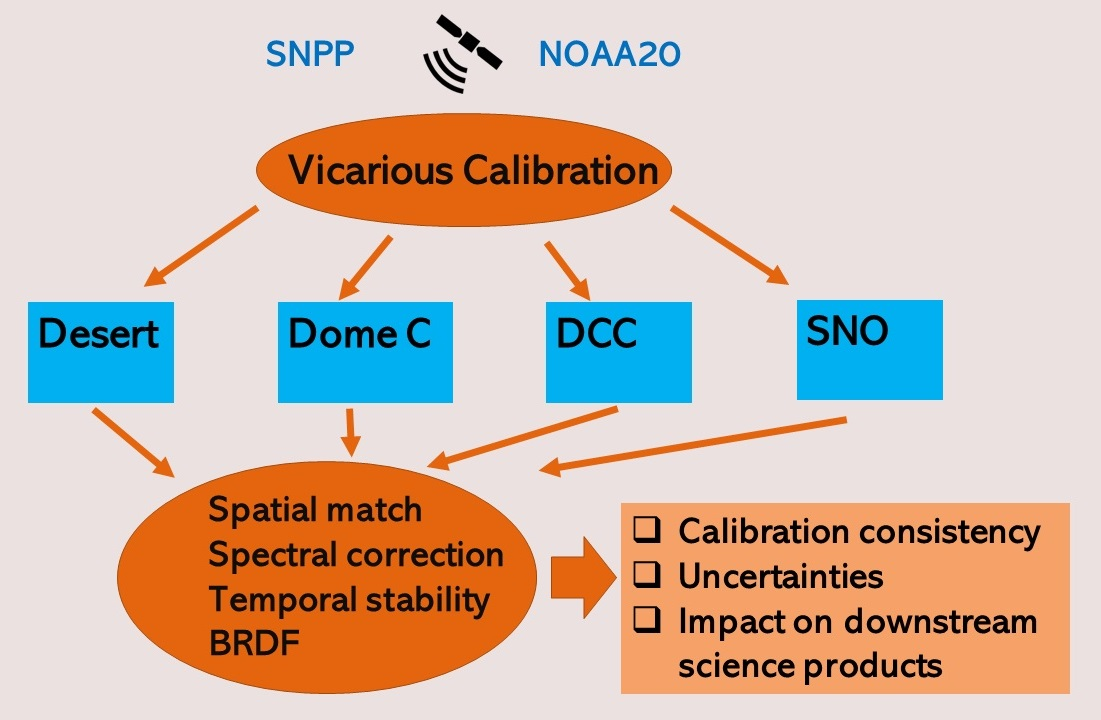
2. Method
2.1. Instrument Background
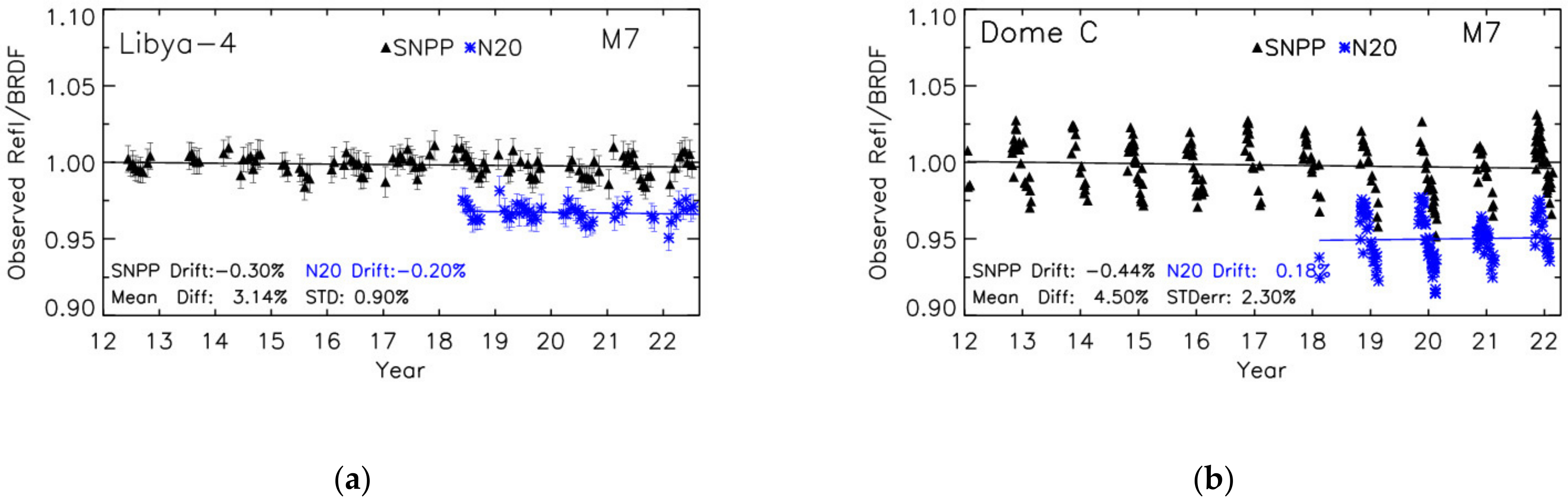
2.2. Libya-4 Site
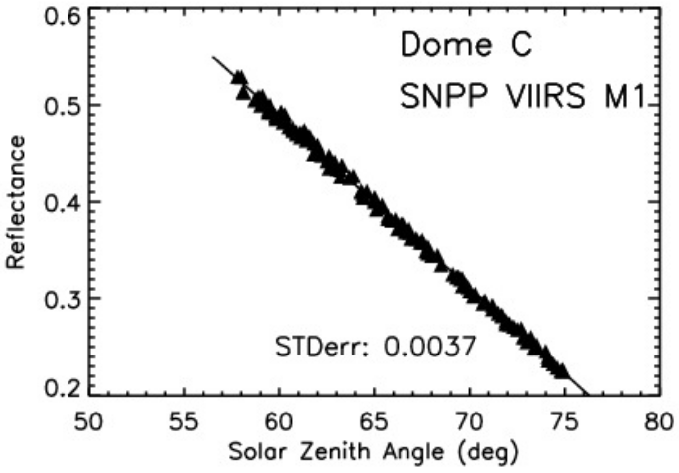
2.3. Dome C Site
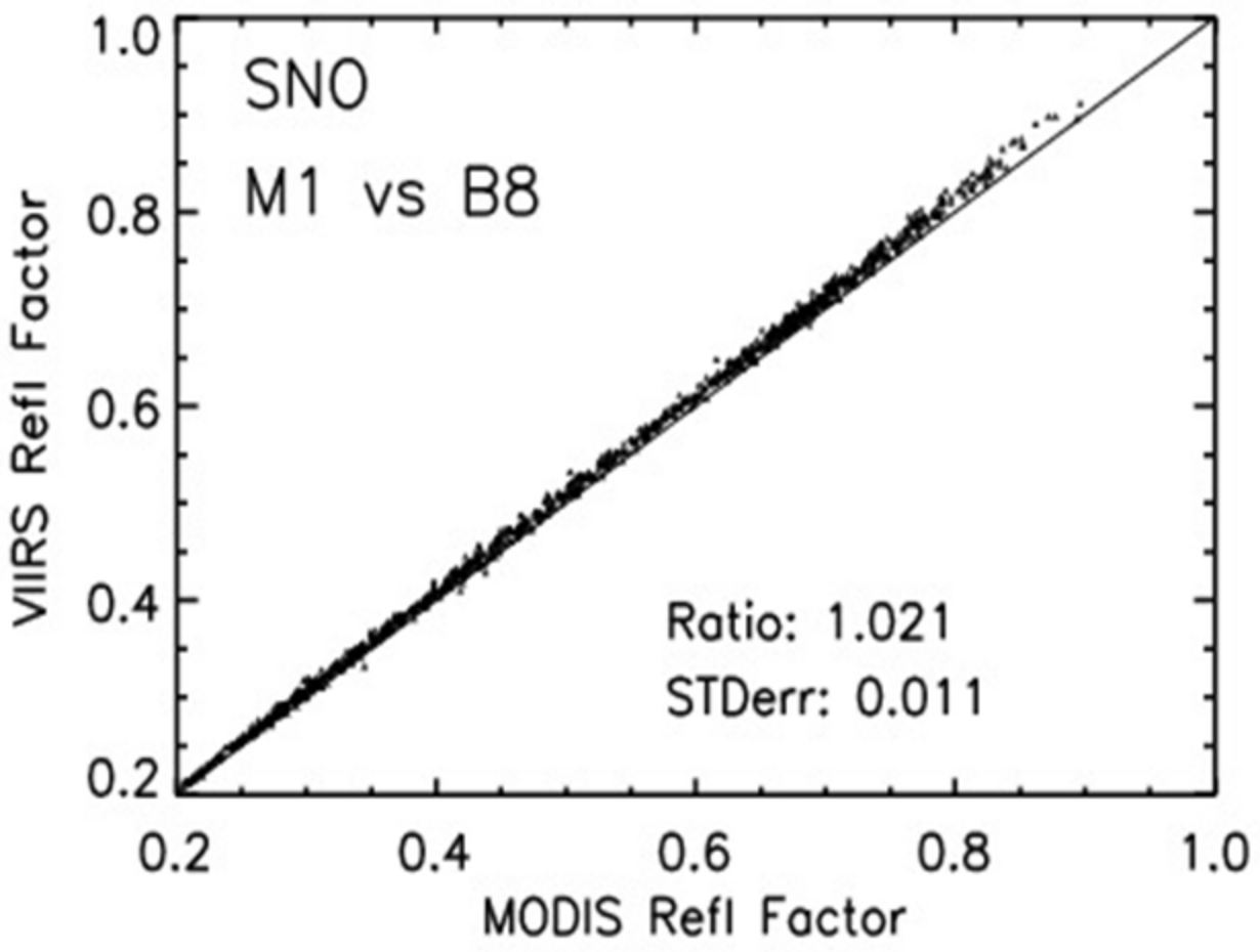
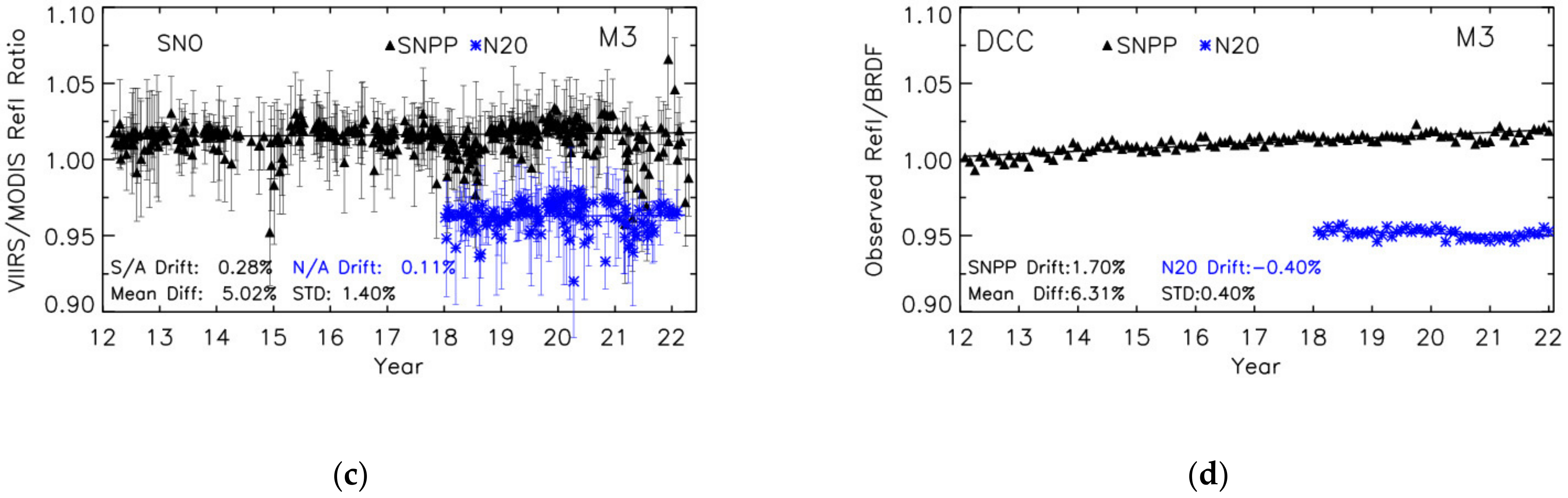
2.4. SNO
2.5. DCC
2.6. Correction for Spectral Differences
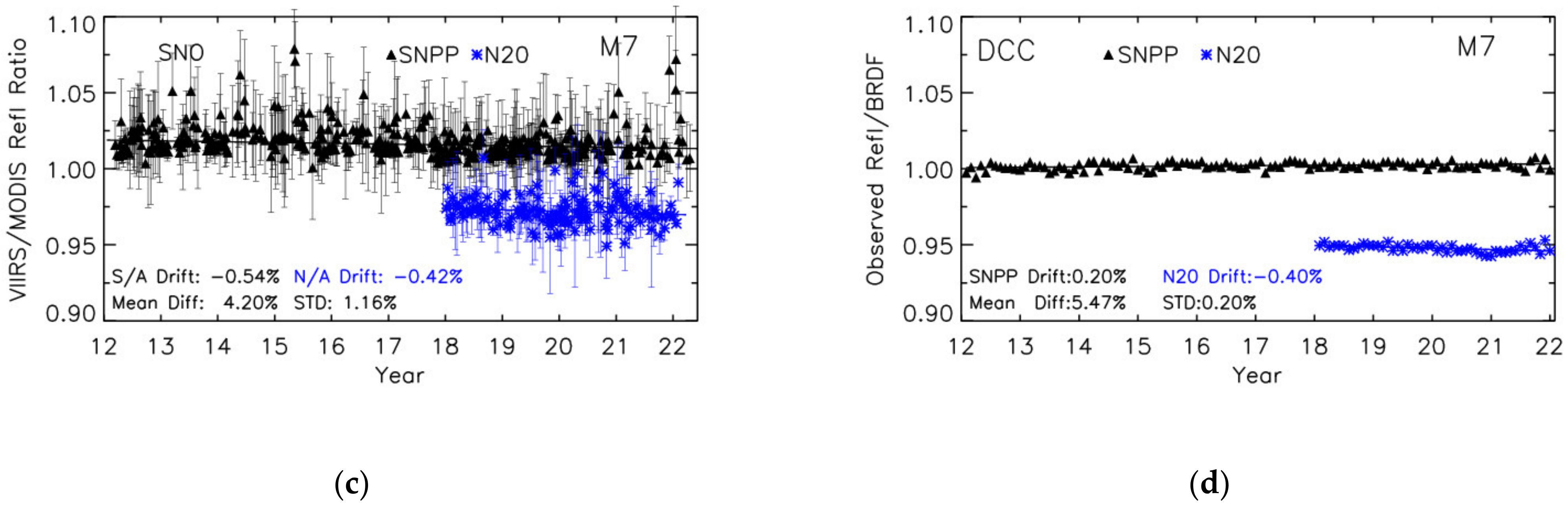
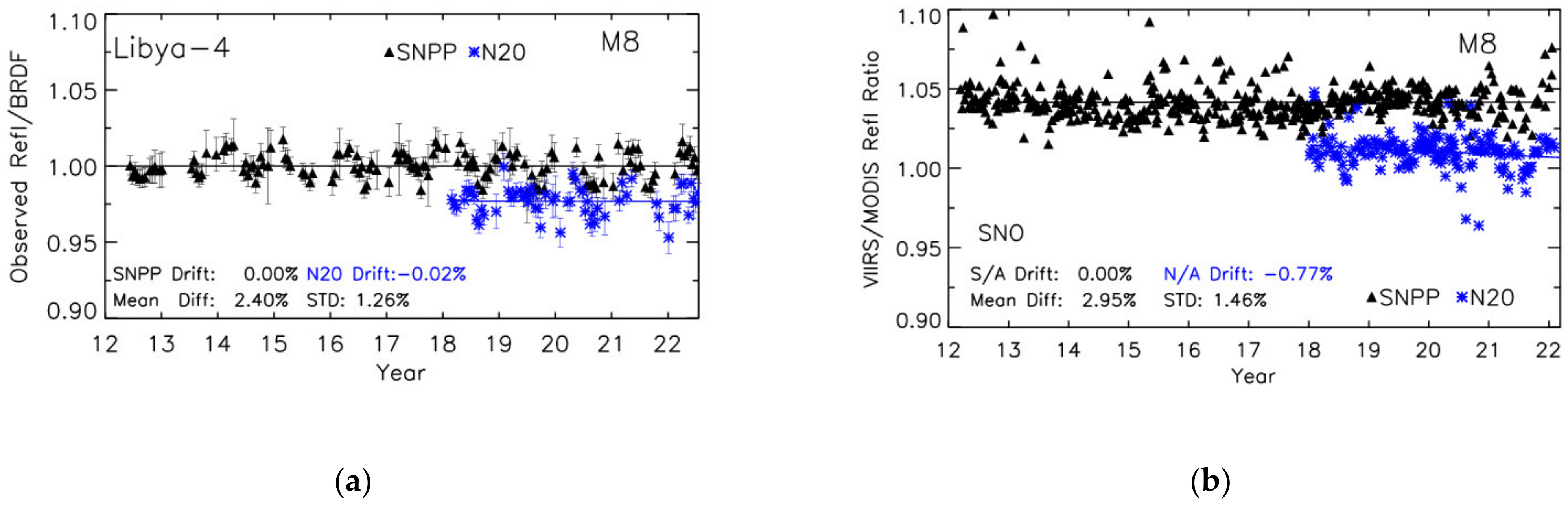
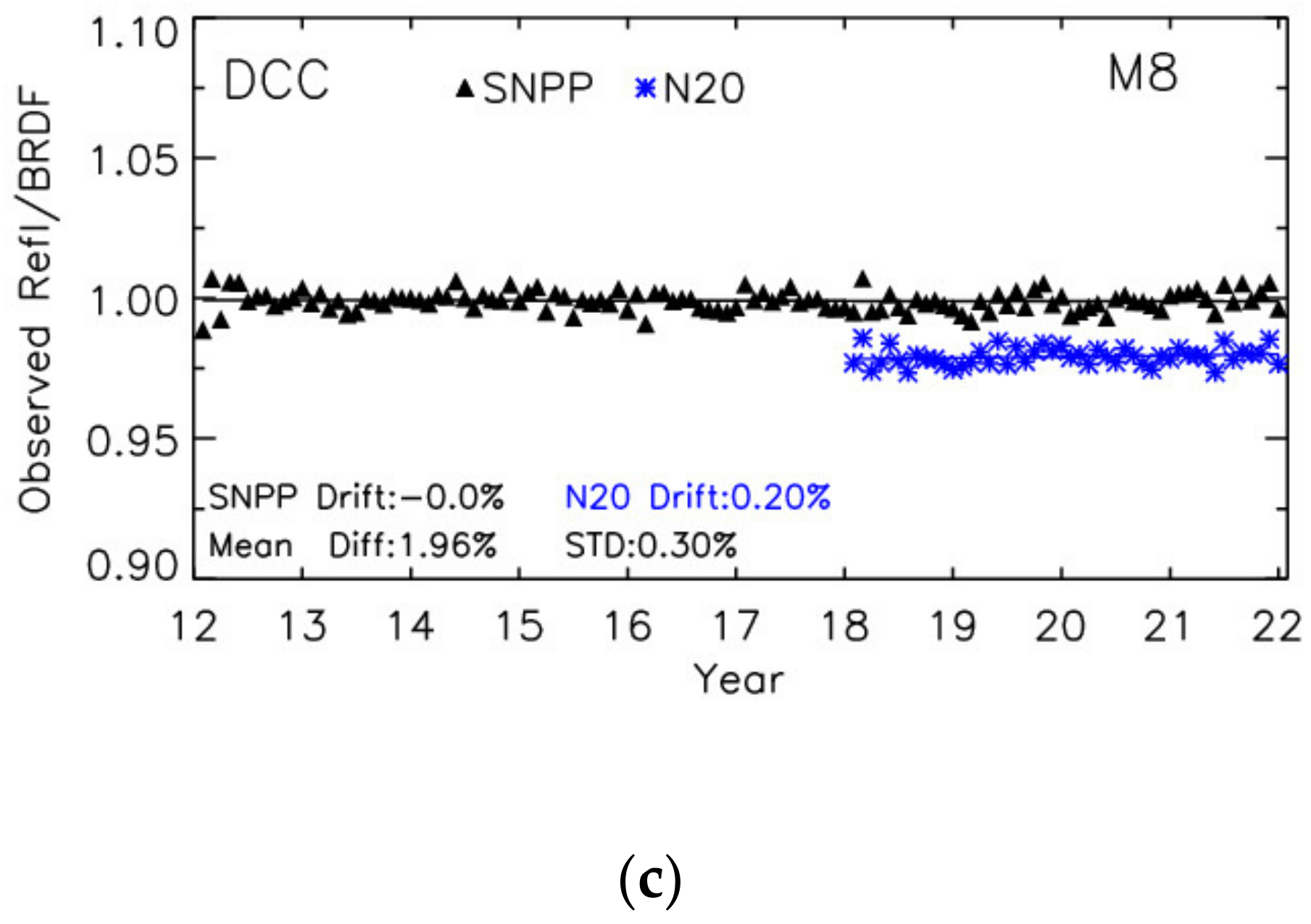
3. Results
4. Discussion
5. Conclusions
Author Contributions
Funding
Data Availability Statement
Conflicts of Interest
References
- Justice, C.O.; Román, M.O.; Csiszar, I.; Vermote, E.F.; Wolfe, R.E.; Hook, S.J.; Friedl, M.; Wang, Z.; Schaaf, C.B.; Miura, T.; et al. Land and cryosphere products from Suomi NPP VIIRS: Overview and status. J. Geophys. Res. Atmos. 2013, 118, 9753–9765. [Google Scholar] [CrossRef] [Green Version]
- Wang, M.; Liu, X.; Tan, L.; Jiang, L.; Son, S.; Shi, W.; Rausch, K.; Voss, K. Impacts of VIIRS SDR performance on ocean color products. J. Geophys. Res. Atmos. 2013, 118, 10347–10360. [Google Scholar] [CrossRef]
- Liu, H.; Remer, L.A.; Huang, J.; Huang, H.-C.; Kondragunta, S.; Laszlo, I.; Oo, M.; Jackson, J.M. Preliminary evaluation of S-NPP VIIRS aerosol optical thickness. J. Geophys. Res. Atmos. 2014, 119, 3942–3962. [Google Scholar] [CrossRef]
- Schueler, C.F.; Clement, J.E.; Ardanuy, P.E.; Welsch, C.; DeLuccia, F.; Swenson, H. NPOESS VIIRS sensor design overview. In Proceedings of the International Symposium on Optical Science and Technology, San Diego, CA, USA, 29 July–3 August 2001; Volume 4483, pp. 11–24. [Google Scholar] [CrossRef]
- Murphy, R.E.; Ardanuy, P.; Deluccia, F.J.; Clement, J.E.; Schueler, C.F. The Visible Infrared Imaging Radiometer Suite. In Earth Science Satellite Remote Sensing; Springer: Berlin/Heidelberg, Germany, 2006; pp. 199–223. [Google Scholar] [CrossRef]
- Cao, C.; De Luccia, F.J.; Xiong, X.; Wolfe, R.; Weng, F. Early on-Orbit Performance of the Visible Infrared Imaging Radiometer Suite Onboard the Suomi National Polar-Orbiting Partnership (S-NPP) Satellite. IEEE Trans. Geosci. Remote Sens. 2014, 52, 1142–1156. [Google Scholar] [CrossRef] [Green Version]
- Xiong, X.; Butler, J.; Chiang, K.; Efremova, B.; Fulbright, J.; Lei, N.; McIntire, J.; Oudrari, H.; Sun, J.; Wang, Z.; et al. VIIRS on-orbit calibration methodology and performance. J. Geophys. Res. Atmos. 2014, 119, 5065–5078. [Google Scholar] [CrossRef]
- Lei, N.; Xiong, X. Products of the SNPP VIIRS SD screen transmittance and the SD BRDFs from both yaw maneuver and regular on-orbit data. IEEE Trans. Geosci. Remote Sens. 2017, 55, 1975–1987. [Google Scholar] [CrossRef]
- Lei, N.; Xiong, X. Determination of the NOAA-20 VIIRS screen transmittance functions with both the yaw maneuver and regular on-orbit calibration data. Appl. Opt. 2020, 59, 2992–3001. [Google Scholar] [CrossRef]
- Xiong, X.; Sun, J.; Fulbright, J.; Wang, Z.; Butler, J.J. Lunar Calibration and Performance for S-NPP VIIRS Reflective Solar Bands. IEEE Trans. Geosci. Remote Sens. 2016, 54, 1052–1061. [Google Scholar] [CrossRef]
- Iona, G.; Butler, J.; Guenther, B.; Graziani, L.; Johnson, E.; Kennedy, B.; Kent, C.; Lambeck, R.; Waluschka, E.; Xiong, X. VIIRS on-orbit optical anomaly: Investigation, analysis, root cause determination and lessons learned. Proc. SPIE 2012, 8510, 85101C. [Google Scholar] [CrossRef] [Green Version]
- Lei, N.; Xiong, X.; Guenther, B. Modeling the Detector Radiometric Gains of the Suomi NPP VIIRS Reflective Solar Bands. IEEE Trans. Geosci. Remote Sens. 2015, 53, 1565–1573. [Google Scholar] [CrossRef]
- Choi, T.; Shao, X.; Cao, C. On-orbit radiometric calibration of Suomi NPP VIIRS reflective solar bands using the Moon and solar diffuser. Appl. Opt. 2018, 57, 9533–9542. [Google Scholar] [CrossRef]
- Xiong, X.; Angal, A.; Chang, T.; Chiang, K.; Lei, N.; Li, Y.; Sun, J.; Twedt, K.; Wu, A. MODIS and VIIRS Calibration and Characterization in Support of Producing Long-Term High-Quality Data Products. Remote Sens. 2020, 12, 3167. [Google Scholar] [CrossRef]
- Mu, Q.; Angal, A.; Twedt, K.; Wu, A.; Xiong, X. MODIS detector differences using deep convective clouds and desert targets. In Proceedings of the SPIE Remote Sensing, Online, 20 September 2020; Volume 11530, p. 115301A. [Google Scholar] [CrossRef]
- Sun, J.; Xiong, X.; Lei, N.; Li, S.; Twedt, K.; Angal, A. Ten Years of SNPP VIIRS Reflective Solar Bands On-Orbit Calibration and Performance. Remote Sens. 2021, 13, 2944. [Google Scholar] [CrossRef]
- Wu, A.; Mu, Q.; Angal, A.; Xiong, X. Assessment of MODIS and VIIRS calibration consistency for reflective solar bands calibration using vicarious approaches. In Proceedings of the Sensors, Systems, and Next-Generation Satellites XXIV, Online, 21–25 September 2020; Volume 11530, p. 1153018. [Google Scholar] [CrossRef]
- Uprety, S.; Cao, C.; Shao, X. Radiometric consistency between GOES-16 ABI and VIIRS on Suomi NPP and NOAA-20. J. Appl. Remote Sens. 2020, 14, 032407. [Google Scholar] [CrossRef]
- Wang, W.; Cao, C. Evaluation of NOAA-20 VIIRS Reflective Solar Bands Early On-Orbit Performance Using Daily Deep Convective Clouds Recent Improvements. IEEE J. Sel. Top. Appl. Earth Obs. Remote Sens. 2020, 13, 3975–3985. [Google Scholar] [CrossRef]
- Teillet, P.M.; Barsi, J.A.; Chander, G.; Thome, K.J. Prime candidate earth targets for the post-launch radiometric calibration of space-based optical imaging instruments. In Proceedings of the Earth Observing Systems XII, San Diego, CA, USA, 26–30 August 2007; p. 66770S. [Google Scholar]
- Chander, G.; Xiong, X.; Choi, T.; Angal, A. Monitoring on-orbit calibration stability of the Terra MODIS and Landsat 7 ETM+ sensors using pseudo-invariant test sites. Remote Sens. Environ. 2010, 114, 925–939. [Google Scholar] [CrossRef]
- Helder, D.; Thome, K.J.; Mishra, N.; Chander, G.; Xiong, X.; Angal, A.; Choi, T. Absolute Radiometric Calibration of Landsat Using a Pseudo Invariant Calibration Site. IEEE Trans. Geosci. Remote Sens. 2013, 51, 1360–1369. [Google Scholar] [CrossRef]
- Doelling, D.R.; Wu, A.; Xiong, X.; Scarino, B.R.; Bhatt, R.; Haney, C.O.; Morstad, D.; Gopalan, A. The Radiometric Stability and Scaling of Collection 6 Terra- and Aqua-MODIS VIS, NIR, and SWIR Spectral Bands. IEEE Trans. Geosci. Remote Sens. 2015, 53, 4520–4535. [Google Scholar] [CrossRef]
- Roujean, J.-L.; Leroy, M.; Deschamps, P.Y. A bidirectional reflectance model of the Earth’s surface for the correction of remote sensing data. J. Geophys. Res. 1992, 97, 20455–20468. [Google Scholar] [CrossRef]
- Wu, A.X.; Xiong, D.R.; Doelling, D.; Morstad, A.; Angal, A.; Bhatt, R. Characterization of Terra and Aqua MODIS VIS, NIR, and SWIR Spectral Bands’ Calibration Stability. IEEE Trans. Geosci. Remote Sens. 2012, 51, 4330–4338. [Google Scholar] [CrossRef]
- Six, D.; Fily, M.; Alvain, S.; Henry, P.; Benoist, J.-P. Surface characterization of the dome concordia area (Antarctica) as a potential satellite calibration site using spot 4/vegetation instrument. Remote Sens. Environ. 2004, 89, 83–94. [Google Scholar] [CrossRef]
- Wu, A.; Xiong, X.; Cao, C.; Chiang, K.-F. Assessment of SNPP VIIRS VIS/NIR Radiometric Calibration Stability Using Aqua MODIS and Invariant Surface Targets. IEEE Trans. Geosci. Remote Sens. 2016, 54, 2918–2924. [Google Scholar] [CrossRef]
- Wu, A.; Xiong, X.; Cao, C. Using BRDF derived from MODIS observations over Dome C to characterize calibration stability and consistency of POS sensors. Proc. SPIE 2009, 7456, 745605. [Google Scholar] [CrossRef]
- Cao, C.; Weinreb, M.; Xu, H. Predicting simultaneous nadir overpasses among polar-orbiting meteorological satellites for intersatellite calibration of radiometers. J. Atmos. Ocean. Technol. 2004, 21, 537–542. [Google Scholar] [CrossRef]
- Wu, A.; Xiong, X.; Cao, C. Terra and Aqua MODIS inter-comparison of three reflective solar bands using AVHRR onboard the NOAA-KLM satellites. Int. J. Remote Sens. 2008, 29, 1997–2010. [Google Scholar] [CrossRef]
- Doelling, D.R.; Morstad, D.; Scarino, B.R.; Bhatt, R.; Gopalan, A. The Characterization of Deep Convective Clouds as an Invariant Calibration Target and as a Visible Calibration Technique. IEEE Trans. Geosci. Remote Sens. 2013, 51, 1147–1159. [Google Scholar] [CrossRef]
- Bhatt, R.; Doelling, D.R.; Scarino, B.R.; Gopalan, A.; Haney, C.O. An initial assessment of the VIIRS onboard calibration using DCC and desert referenced to the Aqua-MODIS calibration. In Earth Observing Systems XVIII; SPIE: San Diego, CA, USA, 2013; Volume 8866, p. 88660K. [Google Scholar] [CrossRef]
- Hu, Y.; Wielicki, B.; Yang, P.; Stackhouse, P.; Lin, B.; Young, D. Application of deep convective cloud albedo observations to satellite-based study of terrestrial atmosphere: Monitoring stability of space-borne measurements and assessing absorption anomaly. IEEE Trans. Geosci. Remote Sens. 2004, 42, 2594–2599. [Google Scholar]
- Platnick, S.; Li, J.Y.; King, M.; Gerber, H.; Hobbs, P.V. A solar reflectance method for retrieving the optical thickness and droplet size of liquid water clouds over snow and ice surfaces. J. Geophys. Res. Earth Surf. 2001, 106, 15185–15199. [Google Scholar] [CrossRef] [Green Version]
- Bhatt, R.; Doelling, D.R.; Scarino, B.; Haney, C.; Gopalan, A. Development of Seasonal BRDF Models to Extend the Use of Deep Convective Clouds as Invariant Targets for Satellite SWIR-Band Calibration. Remote Sens. 2017, 9, 1061. [Google Scholar] [CrossRef] [Green Version]
- Bhatt, R.; Doelling, D.R.; Scarino, B.R.; Gopalan, A.; Haney, C.O. Advances in utilizing tropical deep convective clouds as a stable target for on-orbit calibration of satellite imager reflective solar bands. Proc. SPIE 2019, 11127, 111271H. [Google Scholar] [CrossRef]
- Gottwald, M.; Bovensmann, H. SCIAMACHY—Exploring the Changing Earth’s Atmosphere; Springer: New York, NY, USA, 2011. [Google Scholar]
- Scarino, B.R.; Doelling, D.R.; Minnis, P.; Gopalan, A.; Chee, T.; Bhatt, R.; Lukashin, C.; Haney, C. A Web-Based Tool for Calculating Spectral Band Difference Adjustment Factors Derived from SCIAMACHY Hyperspectral Data. IEEE Trans. Geosci. Remote Sens. 2016, 54, 2529–2542. [Google Scholar] [CrossRef]
- Wang, Z.; Xiong, X.; Fulbright, J.; Lei, N. VIIRS day/night band radiometric calibration stability monitoring using the Moon. J. Geophys. Res. Atmos. 2017, 122, 5616–5624. [Google Scholar] [CrossRef]
- Moyer, D.I.; Uprety, S.; Wang, W.; Cao, C.; Guch, I. S-NPP/NOAA-20 VIIRS reflective solar bands on-orbit calibration bias investigation. Proc. SPIE 2021, 11829, 1182912. [Google Scholar] [CrossRef]
- Meyer, K.; Platnick, S.; Holz, R.; Dutcher, S.; Quinn, G.; Nagle, F. Derivation of Shortwave Radiometric Adjustments for SNPP and NOAA-20 VIIRS for the NASA MODIS-VIIRS Continuity Cloud Products. Remote Sens. 2020, 12, 4096. [Google Scholar] [CrossRef]
- Sayer, A.M.; Hsu, N.C.; Bettenhausen, C.; Holz, R.E.; Lee, J.; Quinn, G.; Veglio, P. Cross-calibration of S-NPP VIIRS moderate-resolution reflective solar bands against MODIS Aqua over dark water scenes. Atmos. Meas. Tech. 2017, 10, 1425–1444. [Google Scholar] [CrossRef] [PubMed] [Green Version]
- Wielicki, B.A.; Young, D.F.; Mlynczak, M.G.; Thome, K.J.; Leroy, S.; Corliss, J.; Anderson, J.G.; Ao, C.O.; Bantges, R.; Best, F.; et al. Achieving climate change absolute accuracy in orbit. Bull. Am. Meteorol. Soc. 2013, 94, 1519–1539. [Google Scholar] [CrossRef] [Green Version]


| Band | Wavelength (µm) | Bandwidth (µm) | Gain Mode | Ltyp | SNR Spec. | Primary Use |
|---|---|---|---|---|---|---|
| I1 | 0.64 | 0.08 | Single | 22 | 119 | Imagery |
| I2 | 0.865 | 0.039 | Single | 25 | 150 | Imagery |
| I3 | 1.61 | 0.06 | Single | 7.3 | 6 | Imagery |
| M1 | 0.412 | 0.02 | Low/High | 44.9/155 | 352/316 | Ocean Color, Aerosol |
| M2 | 0.445 | 0.018 | Low/High | 40/146 | 380/409 | Ocean Color, Aerosol |
| M3 | 0.488 | 0.02 | Low/High | 32/123 | 416/414 | Ocean Color, Aerosol |
| M4 | 0.555 | 0.02 | Low/High | 21/90 | 362/315 | Ocean Color, Aerosol |
| M5 | 0.672 | 0.02 | Low/High | 10/68 | 242/360 | Ocean Color, Aerosol |
| M6 | 0.746 | 0.015 | Single | 9.6 | 199 | Atmospheric corr’n |
| M7 | 0.865 | 0.039 | Low/High | 6.4/33.4 | 215/340 | Ocean Color, Aerosol |
| M8 | 1.24 | 0.02 | Single | 5.4 | 74 | Cloud optical thickness over snow/ice |
| M9 | 1.378 | 0.015 | Single | 6 | 83 | Cirrus/Cloud Cover |
| M10 | 1.61 | 0.06 | Single | 7.3 | 342 | Snow Fraction |
| M11 | 2.25 | 0.05 | Single | 0.12 (1) | 10 (90) | Clouds |
| Band (µm) | M1 0.412 | M2 0.445 | M3 0.488 | M4 0.555 | M5 0.672 | M7 0.865 | M8 1.24 | M9 1.378 | M10 1.61 | M11 2.25 | I1 0.640 | I2 0.865 | I3 1.61 |
|---|---|---|---|---|---|---|---|---|---|---|---|---|---|
| Libya-4 | 1.004 | 1.012 | 0.996 | 1.019 | 1.000 | 0.994 | 1.001 | NA | 0.999 | 0.990 | 1.002 | 0.992 | 0.997 |
| DCC | 1.000 | 1.008 | 1.000 | 0.994 | 1.001 | 0.998 | 1.000 | 1.001 | 1.013 | 0.992 | 1.003 | 0.996 | 1.015 |
| Dome C | 1.015 | 1.013 | 0.994 | 0.983 | 1.002 | 0.978 | 0.993 | NA | 1.017 | 0.988 | 0.992 | 0.979 | 0.999 |
| SNO | 1.013 | 1.012 | 0.993 | 0.989 | 1.001 | 0.990 | 1.000 | 1.003 | 1.001 | 0.993 | 0.995 | 0.986 | 0.999 |
| Band (µm) | M1 0.412 | M2 0.445 | M3 0.488 | M4 0.555 | M5 0.672 | M7 0.865 | M8 1.24 | M9 1.378 | M10 1.61 | M11 2.25 | I1 0.640 | I2 0.865 | I3 1.61 |
|---|---|---|---|---|---|---|---|---|---|---|---|---|---|
| Libya-4 | −0.63 ±0.83 | −0.67 ±0.78 | −0.61 ±0.90 | −0.65 ±0.86 | −0.37 ±0.64 | −0.53 ±0.64 | −0.29 ±0.85 | NA | −0.29 ±0.50 | −0.10 ±1.47 | −0.63 ±0.81 | −0.49 ±0.69 | −0.37 ±0.48 |
| DCC | 1.35 ±0.40 | 0.74 ±0.22 | 1.70 ±0.30 | 1.20 ±0.30 | 0.80 ±0.30 | 0.20 ±0.20 | −0.00 ±0.40 | 0.60 ±0.80 | 0.20 ±0.70 | 0.10 ±0.50 | 0.60 ±0.30 | 0.40 ±0.20 | 0.10 ±0.70 |
| Dome C | 1.16 ±0.76 | 0.66 ±0.81 | 1.53 ±0.89 | 2.12 ±1.86 | 0.98 ±1.31 | −0.31 ±1.71 | NA | NA | NA | NA | 1.61 ±1.90 | −0.18 ±1.76 | NA |
| SNO | 0.53 ±0.90 | −0.23 ±0.74 | 0.36 ±0.82 | 0.63 ±0.47 | 0.39 ±1.54 | −0.55 ±0.71 | 0.02 ±0.99 | NA | −0.67 ±2.42 | NA | −0.34 ±0.57 | −0.62 ±0.71 | −0.65 ±2.62 |
| Band (µm) | B1 0.645 | B2 0.858 | B3 0.469 | B4 0.555 | B5 1.24 | B6 1.64 | B7 2.13 | B8 0.412 | B9 0.443 |
|---|---|---|---|---|---|---|---|---|---|
| Libya-4 | 0.56 ±0.99 | 0.50 ±1.05 | 0.30 ±1.47 | 0.55 ±1.21 | −0.18 ±0.97 | −0.07 ±0.83 | −0.38 ±1.93 | −1.12 ±1.45 | −0.31 ±1.50 |
| Dome C | 0.18 ±2.08 | 0.11 ±1.91 | 0.15 ±0.92 | 0.58 ±1.05 | −0.05 ±2.29 | NA | NA | −1.20 ±0.96 | −0.47 ±1.25 |
| DCC | −0.26 ±0.85 | NA | 0.82 ±0.86 | 0.41 ±0.86 | 0.01 ±0.60 | 0.80 ±1.68 | 0.32 ±2.48 | NA | NA |
| Band | M1 | M2 | M3 | M4 | M5 | M7 | M8 | M9 | M10 | M11 | I1 | I2 | I3 |
|---|---|---|---|---|---|---|---|---|---|---|---|---|---|
| Libya−4 | −0.09 ±0.71 | 0.04 ±0.83 | −0.48 ±0.91 | −0.72 ±0.69 | −0.61 ±0.55 | −0.75 ±0.65 | −0.55 ±0.94 | NA | −0.30 ±0.65 | −0.60 ±1.60 | −0.89 ±0.87 | −0.78 ±0.93 | −0.24 ±0.62 |
| DCC | −0.86 ±0.85 | −1.29 ±0.92 | −0.40 ±0.30 | −0.50 ±0.40 | −0.20 ±0.30 | −0.40 ±0.20 | 0.20 ±0.30 | 0.30 ±0.80 | 0.60 ±0.70 | 0.50 ±0.50 | −0.50 ±0.30 | −0.54 ±0.64 | 0.50 ±0.70 |
| Dome C | 0.98 ±0.78 | 0.32 ±0.70 | 0.71 ±0.92 | 2.17 ±2.35 | 0.81 ±1.60 | 0.18 ±1.81 | NA | NA | NA | NA | 1.54 ±2.07 | 0.36 ±1.81 | NA |
| SNO | −0.23 ±1.19 | 0.20 ±0.80 | 0.11 ±1.12 | 0.25 ±0.49 | 0.35 ±0.96 | −0.42 ±0.92 | −0.77 ±1.08 | NA | −2.11 ±2.12 | NA | −0.18 ±0.53 | −0.31 ±0.91 | −1.45 ±1.91 |
| Band | M1 | M2 | M3 | M4 | M5 | M7 | M8 | M9 | M10 | M11 | I1 | I2 | I3 |
|---|---|---|---|---|---|---|---|---|---|---|---|---|---|
| Libya-4 | 0.925 ±0.011 | 0.938 ±0.011 | 0.956 ±0.013 | 0.966 ±0.011 | 0.954 ±0.008 | 0.975 ±0.009 | 0.976 ±0.013 | NA | 0.982 ±0.008 | 0.979 ±0.022 | 0.970 ±0.012 | 0.974 ±0.012 | 0.969 ±0.008 |
| DCC | 0.941 ±0.009 | 0.942 ±0.009 | 0.948 ±0.003 | 0.945 ±0.003 | 0.949 ±0.003 | 0.960 ±0.002 | 0.982 ±0.003 | 0.989 ±0.008 | 0.988 ±0.007 | 0.988 ±0.005 | 0.952 ±0.003 | 0.970 ±0.007 | 0.965 ±0.007 |
| Dome C | 0.921 ±0.011 | 0.934 ±0.009 | 0.950 ±0.011 | 0.952 ±0.026 | 0.966 ±0.025 | 0.975 ±0.023 | NA | NA | NA | NA | 0.966 ±0.025 | 0.973 ±0.023 | NA |
| SNO | 0.935 ±0.015 | 0.941 ±0.011 | 0.956 ±0.014 | 0.948 ±0.007 | 0.946 ±0.018 | 0.968 ±0.017 | 0.971 ±0.015 | NA | 0.971 ±0.033 | NA | 0.967 ±0.008 | 0.969 ±0.016 | 0.961 ±0.033 |
Publisher’s Note: MDPI stays neutral with regard to jurisdictional claims in published maps and institutional affiliations. |
© 2022 by the authors. Licensee MDPI, Basel, Switzerland. This article is an open access article distributed under the terms and conditions of the Creative Commons Attribution (CC BY) license (https://creativecommons.org/licenses/by/4.0/).
Share and Cite
Wu, A.; Xiong, X.; Bhatt, R.; Haney, C.; Doelling, D.R.; Angal, A.; Mu, Q. An Assessment of SNPP and NOAA20 VIIRS RSB Calibration Performance in NASA SIPS Reprocessed Collection-2 L1B Data Products. Remote Sens. 2022, 14, 4134. https://doi.org/10.3390/rs14174134
Wu A, Xiong X, Bhatt R, Haney C, Doelling DR, Angal A, Mu Q. An Assessment of SNPP and NOAA20 VIIRS RSB Calibration Performance in NASA SIPS Reprocessed Collection-2 L1B Data Products. Remote Sensing. 2022; 14(17):4134. https://doi.org/10.3390/rs14174134
Chicago/Turabian StyleWu, Aisheng, Xiaoxiong Xiong, Rajendra Bhatt, Conor Haney, David R. Doelling, Amit Angal, and Qiaozhen Mu. 2022. "An Assessment of SNPP and NOAA20 VIIRS RSB Calibration Performance in NASA SIPS Reprocessed Collection-2 L1B Data Products" Remote Sensing 14, no. 17: 4134. https://doi.org/10.3390/rs14174134
APA StyleWu, A., Xiong, X., Bhatt, R., Haney, C., Doelling, D. R., Angal, A., & Mu, Q. (2022). An Assessment of SNPP and NOAA20 VIIRS RSB Calibration Performance in NASA SIPS Reprocessed Collection-2 L1B Data Products. Remote Sensing, 14(17), 4134. https://doi.org/10.3390/rs14174134