
Rice Crop Monitoring Using Sentinel-1 SAR Data: A Case Study in Saku, Japan


Abstract
:1. Introduction
2. Datasets
2.1. Study Area
2.2. Satellite Remote Sensing Data and Data Processing
3. Methods
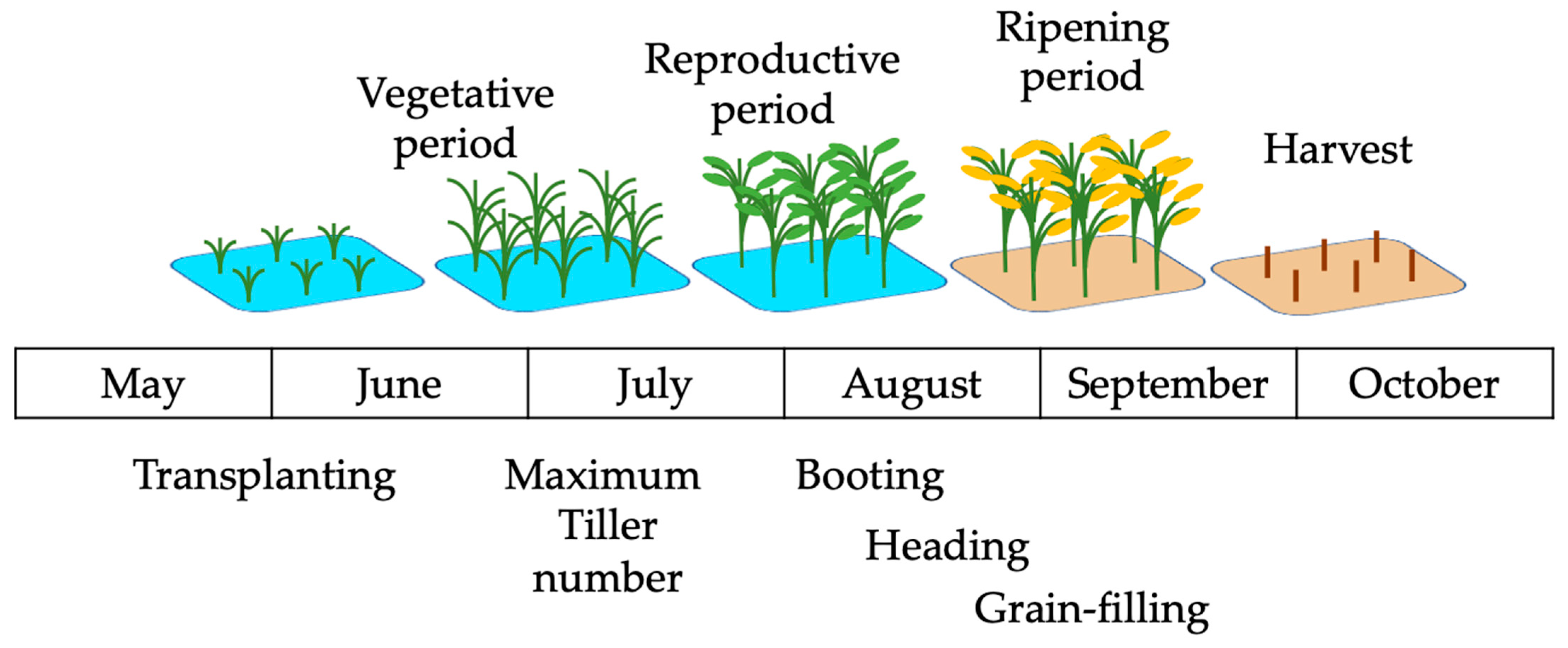
3.1. Field Observations
3.2. Seasonal Change in C-Band Backscatter with Rice Crop Growth
3.3. Statistical Analysis between Field Observations and Satellite Remote Sensing Data
4. Results
4.1. Overall Growth Monitoring Analysis
4.1.1. Field Observational Data
4.1.2. Changes in Sentinel-1 Radar Backscattering
4.2. Multivariate Regression Analysis
5. Discussion
5.1. Rice Crop Growth
5.2. Seasonal Changes in Backscattered Microwave according to Rice Crop Growth
- Transplanting period: Backscatters in both VV and VH showed a clear decrease in early June, at the end of the transplanting period. The low backscatter values here are most likely related to the specular reflection of the irrigated water surface [45]. After the transplanting, a water depth of about 3–4 cm is kept until the seedling takes root, and the tips of the seedling leaves can only be seen on the water surface. Therefore, the surface condition immediately after planting is similar to a flat-water surface, which generates low backscattered signals. However, paddy fields within 2 or 3 days after transplanting showed markedly high backscatter values, likely caused by a ridge appearing on the water surface created by the rice transplanting machine. Accordingly, the C-band SAR data taken in the days following transplantation should be excluded from the analysis.
- Vegetative period: The results uniquely demonstrated that VV/VH increased in the early tillering stage before suddenly decreasing in the latter tillering stage. This finding indicates that VV in the early stage increased more rapidly than VH because of the steady increase in plant height (Figure 4a). As a basic scattering mechanism, a vertically polarized microwave is transmitted toward the ground both in VV and VH polarization. When the surface has a vertical component, the received signal becomes stronger in a vertical direction and consists of surface and double-bounce scatterings [46]. Part of the transmitted signal is depolarized by multiple scatterers, such as vegetation, to be received in the orthogonal plane of H [29,47]. The sensitivity of VV to vegetation growth is due to double bounce scattering between plant and water surfaces [48], with the backscatter increasing with larger canopy gaps [49]. Next, the sudden decrease in VV/VH can be explained by the increased stem number and panicle initiation through active tillering. The increased tillers and randomly shaped panicles induce canopy growth to generate backscatter signals in cross-polarization [29] while suppressing the like-polarization backscatter because of microwave attenuation by vertical plant structures [27,29]; thus, the substantial increase in VH leads to the decrease in VV/VH. Previous studies have also illustrated that vegetation growth, as the main scatterer, strongly increases VH and slightly increases VV during the vegetative phase [15,21,22]. The results here showed a similar tendency, additionally revealing a clear inflection point in VV/VH in the middle of the vegetative stage due to the accompanying apparent morphological transformation.
5.3. Statistical Analysis between Ground Observation and C-Band Backscattering
6. Conclusions
Author Contributions
Funding
Data Availability Statement
Acknowledgments
Conflicts of Interest
References
- Fukagawa, N.K.; Ziska, L.H. Rice: Importance for global nutrition. J. Nutr. Sci. Vitaminol. 2019, 65, S2–S3. [Google Scholar] [CrossRef] [PubMed] [Green Version]
- Karthikeyan, L.; Chawla, I.; Mishra, A.K. A review of remote sensing applications in agriculture for food security: Crop growth and yield, irrigation, and crop losses. J. Hydrol. 2020, 586, 124905. [Google Scholar] [CrossRef]
- The Ministry of Agriculture Forestry and Fisheries of Japan. To Overcome the High Temperature Damage of Paddy Rice. High Temperature Damage Countermeasure Report. Available online: https://www.maff.go.jp/j/kanbo/kihyo03/gityo/g_kiko_hendo/suito_kouon/pdf/report.pdf (accessed on 4 June 2022). (In Japanese)
- Fahad, S.; Adnan, M.; Hassan, S.; Saud, S.; Hussain, S.; Wu, C.; Wang, D.; Hakeem, K.R.; Alharby, H.F.; Turan, V.; et al. Rice Responses and Tolerance to High Temperature. In Advances in Rice Research for Abiotic Stress Tolerance; Woodhead Publishing: Cambridge, UK, 2019; pp. 201–224. [Google Scholar]
- Sakaiya, E.; Inoue, Y. Operational Use of Remote Sensing for Harvest Management of Rice. J. Remote Sens. Soc. Jpn. 2013, 33, 185–199. (In Japanese) [Google Scholar]
- Brouwer, C.; Prins, K.; Heibloem, M. Irrigation Water Management: Irrigation Scheduling; Water Resources, Development and Management Service Land and Water Development Division; FAO: Rome, Italy, 1989. [Google Scholar]
- Morris, M.L. Rice Production: A Training Manual and Field Guide to Small-Farm Irrigated Rice Production; Peace Corps, Information Collection and Exchange: Washington, DC, USA, 1980. [Google Scholar]
- Yoshida, S. Fundamentals of Rice Crop Science; The International Rice Research Institute: Manila, Philippines, 1981. [Google Scholar]
- Ishitsuka, N.; Ouchi, K. The Application of Synthetic Aperture Radar to Agriculture. J. Remote Sens. Soc. Jpn. 2017, 37, 182–192. (In Japanese) [Google Scholar]
- Liu, C.-A.; Chen, Z.-X.; Shao, Y.; Chen, J.-S.; Hasi, T.; Pan, H.-Z. Research advances of SAR remote sensing for agriculture applications: A review. J. Integr. Agric. 2019, 18, 506–525. [Google Scholar] [CrossRef] [Green Version]
- Xu, C.; Qu, J.J.; Hao, X.; Cosh, M.H.; Zhu, Z.; Gutenberg, L. Monitoring crop water content for corn and soybean fields through data fusion of MODIS and Landsat measurements in Iowa. Agric. Water Manag. 2020, 227, 105844. [Google Scholar] [CrossRef]
- Han, D.; Liu, S.; Du, Y.; Xie, X.; Fan, L.; Lei, L.; Li, Z.; Yang, H.; Yang, G. Crop water content of winter wheat revealed with Sentinel-1 and Sentinel-2 imagery. Sensors 2019, 19, 4013. [Google Scholar] [CrossRef] [Green Version]
- Pan, H.; Chen, Z.; Ren, J.; Li, H.; Wu, S. Modeling winter wheat leaf area index and canopy water content with three different approaches using Sentinel-2 multispectral instrument data. IEEE J. Sel. Top. Appl. Earth Obs. Remote Sens. 2018, 12, 482–492. [Google Scholar] [CrossRef]
- Quemada, C.; Pérez-Escudero, J.M.; Gonzalo, R.; Ederra, I.; Santesteban, L.G.; Torres, N.; Iriarte, J.C. Remote sensing for plant water content monitoring: A review. Remote Sens. 2021, 13, 2088. [Google Scholar] [CrossRef]
- Bazzi, H.; Baghdadi, N.; El Hajj, M.; Zribi, M.; Minh, D.H.T.; Ndikumana, E.; Courault, D.; Belhouchette, H. Mapping Paddy Rice Using Sentinel-1 SAR Time Series in Camargue, France. Remote Sens. 2019, 11, 887. [Google Scholar] [CrossRef] [Green Version]
- Beriaux, E.; Jago, A.; Lucau-Danila, C.; Planchon, V.; Defourny, P. Sentinel-1 Time Series for Crop Identification in the Framework of the Future CAP Monitoring. Remote Sens. 2021, 13, 2785. [Google Scholar] [CrossRef]
- Chang, L.; Chen, Y.-T.; Wang, J.-H.; Chang, Y.-L. Rice-Field Mapping with Sentinel-1A SAR Time-Series Data. Remote Sens. 2020, 13, 103. [Google Scholar] [CrossRef]
- Kumar, P.; Prasad, R.; Gupta, D.K.; Mishra, V.N.; Vishwakarma, A.K.; Yadav, V.P.; Bala, R.; Choudhary, A.; Avtar, R. Estimation of winter wheat crop growth parameters using time series Sentinel-1A SAR data. Geocarto Int. 2017, 33, 942–956. [Google Scholar] [CrossRef]
- Silva-Perez, C.; Marino, A.; Cameron, I. Monitoring Agricultural Fields Using Sentinel-1 and Temperature Data in Peru: Case Study of Asparagus (Asparagus officinalis L.). Remote Sens. 2020, 12, 1993. [Google Scholar] [CrossRef]
- Wali, E.; Tasumi, M.; Moriyama, M. Combination of Linear Regression Lines to Understand the Response of Sentinel-1 Dual Polarization SAR Data with Crop Phenology—Case Study in Miyazaki, Japan. Remote Sens. 2020, 12, 189. [Google Scholar] [CrossRef] [Green Version]
- He, Z.; Li, S.; Wang, Y.; Dai, L.; Lin, S. Monitoring Rice Phenology Based on Backscattering Characteristics of Multi-Temporal RADARSAT-2 Datasets. Remote Sens. 2018, 10, 340. [Google Scholar] [CrossRef] [Green Version]
- Ndikumana, E.; Ho Tong Minh, D.; Dang Nguyen, H.; Baghdadi, N.; Courault, D.; Hossard, L.; El Moussawi, I. Estimation of Rice Height and Biomass Using Multitemporal SAR Sentinel-1 for Camargue, Southern France. Remote Sens. 2018, 10, 1394. [Google Scholar] [CrossRef] [Green Version]
- Harfenmeister, K.; Itzerott, S.; Weltzien, C.; Spengler, D. Agricultural Monitoring Using Polarimetric Decomposition Parameters of Sentinel-1 Data. Remote Sens. 2021, 13, 575. [Google Scholar] [CrossRef]
- Harfenmeister, K.; Spengler, D.; Weltzien, C. Analyzing Temporal and Spatial Characteristics of Crop Parameters Using Sentinel-1 Backscatter Data. Remote Sens. 2019, 11, 1569. [Google Scholar] [CrossRef] [Green Version]
- Khabbazan, S.; Vermunt, P.; Steele-Dunne, S.; Ratering Arntz, L.; Marinetti, C.; van der Valk, D.; Iannini, L.; Molijn, R.; Westerdijk, K.; van der Sande, C. Crop Monitoring Using Sentinel-1 Data: A Case Study from The Netherlands. Remote Sens. 2019, 11, 1887. [Google Scholar] [CrossRef] [Green Version]
- Nasirzadehdizaji, R.; Balik Sanli, F.; Abdikan, S.; Cakir, Z.; Sekertekin, A.; Ustuner, M. Sensitivity Analysis of Multi-Temporal Sentinel-1 SAR Parameters to Crop Height and Canopy Coverage. Appl. Sci. 2019, 9, 655. [Google Scholar] [CrossRef] [Green Version]
- Veloso, A.; Mermoz, S.; Bouvet, A.; Le Toan, T.; Planells, M.; Dejoux, J.-F.; Ceschia, E. Understanding the temporal behavior of crops using Sentinel-1 and Sentinel-2-like data for agricultural applications. Remote Sens. Environ. 2017, 199, 415–426. [Google Scholar] [CrossRef]
- Vreugdenhil, M.; Wagner, W.; Bauer-Marschallinger, B.; Pfeil, I.; Teubner, I.; Rüdiger, C.; Strauss, P. Sensitivity of Sentinel-1 Backscatter to Vegetation Dynamics: An Austrian Case Study. Remote Sens. 2018, 10, 1396. [Google Scholar] [CrossRef] [Green Version]
- Henderson, F.M.; Lewis, A.J. Principles and Applications of Imaging Radar (Manual of Remote Sensing: Volume 2); Wiley: New York, NY, USA, 1998. [Google Scholar]
- Yoshihiko, K. Personal Communication; Saku Agricultural and Rural Support Center: Nagano, Japan, 2022. [Google Scholar]
- Filipponi, F. Sentinel-1 GRD preprocessing workflow. Multidiscip. Digit. Publ. Inst. Proc. 2019, 18, 11. [Google Scholar]
- Garrison, J.L. Welcome to the September Issue [From the Editor]. IEEE Geosci. Remote Sens. Mag. 2021, 9, 3–5. [Google Scholar] [CrossRef]
- Kang, Y.; Özdoğan, M. Field-level crop yield mapping with Landsat using a hierarchical data assimilation approach. Remote Sens. Environ. 2019, 228, 144–163. [Google Scholar] [CrossRef]
- Yonezawa, C.; Negishi, M.; Azuma, K.; Watanabe, M.; Ishitsuka, N.; Ogawa, S.; Saito, G. Growth monitoring and classification of rice fields using multitemporal RADARSAT-2 full-polarimetric data. Int. J. Remote Sens. 2012, 33, 5696–5711. [Google Scholar] [CrossRef]
- Anwari, G.; Moussa, A.A.; Wahidi, A.B.; Mandozai, A.; Nasar, J.; El-Rahim, M.G.M.A. Effects of Planting Distance on Yield and Agro-morphological Characteristics of Local Rice (Bara Variety) in Northeast Afghanistan. Curr. Agric. Res. J. 2019, 7, 350–357. [Google Scholar] [CrossRef]
- Sritarapipat, T.; Rakwatin, P.; Kasetkasem, T. Automatic rice crop height measurement using a field server and digital image processing. Sensors 2014, 14, 900–926. [Google Scholar] [CrossRef] [Green Version]
- Tomczak, K.; Tomczak, A.; Jelonek, T. Effect of Natural Drying Methods on Moisture Content and Mass Change of Scots Pine Roundwood. Forests 2020, 11, 668. [Google Scholar] [CrossRef]
- Guo, J.; Zhang, J.X.; Zhao, H.T.; Li, C.; Zhou, J.; Tu, H.J.; Zhao, Y. Horizontal Accuracy Assessment of Google Earth Data over Typical Regions of Asia. Int. Arch. Photogramm. Remote Sens. Spat. Inf. Sci. 2020, XLIII-B3-2020, 1333–1338. [Google Scholar] [CrossRef]
- Bonakdari, H.; Zeynoddin, M. Stochastic Modeling: A Thorough Guide to Evaluate, Pre-Process, Model and Compare Time Series with MATLAB Software; Elsevier Science: Amsterdam, The Netherlands, 2022. [Google Scholar]
- Montgomery, D.C.; Peck, E.A.; Vining, G.G. Introduction to Linear Regression Analysis; John Wiley & Sons: Hoboken, NJ, USA, 2021. [Google Scholar]
- Feng, Z.; Qi, Z.; Zhang, Z.; Zheng, E.; Yu, J.; Zheng, Y. Effective Tiller Numbers, Photosynthetic and Yield Response of Rice (Oryza sativa) to Shallow Wet–Dry Irrigation Water Controlled at Tillering Stage in Black Soil Area. Agric. Res. 2020, 10, 97–104. [Google Scholar] [CrossRef]
- Nozulaidi, M.; Jahan, M.S.; Khairi, M.; Khandaker, M.M.; Nashriyah, M.; Khanif, Y.M. N-acetylcysteine increased rice yield. Turk. J. Agric. For. 2015, 39, 204–211. [Google Scholar] [CrossRef]
- Iwaya, K.; Yamamoto, H. The diagnosis of optimal harvesting time of rice using digital imaging. J. Agric. Meteorol. 2005, 60, 981–984. [Google Scholar] [CrossRef] [Green Version]
- Lasko, K.; Vadrevu, K.P.; Tran, V.T.; Justice, C. Mapping Double and Single Crop Paddy Rice With Sentinel-1A at Varying Spatial Scales and Polarizations in Hanoi, Vietnam. IEEE J. Sel. Top Appl. Earth Obs. Remote Sens. 2018, 11, 498–512. [Google Scholar] [CrossRef]
- Balz, T.; Soergel, U.; Crespi, M.; Osmanoglu, B. Advances in SAR: Sensors, Methodologies, and Applications; MDPI: Basel, Switzerland, 2018. [Google Scholar]
- Flores Anderson, A.I.; Herndon, K.E.; Kucera, L.M. SAR Handbook: Background; SERVIR Global: Huntsville, AL, USA, 2019. [Google Scholar]
- Evans, D.L.; Farr, T.G.; Ford, J.; Thompson, T.W.; Werner, C. Multipolarization radar images for geologic mapping and vegetation discrimination. IEEE Trans. Geosci. Remote Sens. 1986, GE-24, 246–257. [Google Scholar] [CrossRef]
- Bouvet, A.; Le Toan, T.; Lam-Dao, N. Monitoring of the rice cropping system in the Mekong Delta using ENVISAT/ASAR dual polarization data. IEEE Trans. Geosci. Remote Sens. 2009, 47, 517–526. [Google Scholar] [CrossRef] [Green Version]
- Rosenqvist, A.; Killough, B. A Layman’s Interpretation Guide to L-band and C-band Synthetic Aperture Radar Data, v2.0. Available online: https://ceos.org/ard/files/Laymans_SAR_Interpretation_Guide_2.0.pdf (accessed on 24 June 2022).
- Arif, C. Optimizing Water Management in System of Rice Intensification Paddy Fields by Field Monitoring Technology. Ph.D. Thesis, Tokyo University, Tokyo, Japan, 2013. [Google Scholar]


| Field Observation Date | Ascending | Descending | |||||
|---|---|---|---|---|---|---|---|
| Rel_Orb39, Sub-Swath IW1 | Rel_Orb46, Sub-Swath IW3 | ||||||
| Incidence Angle 35–36° | Incidence Angle 45–46° | ||||||
| May 03, 2020 | May 09, 2019 | May 07, 2017 | May 09, 2020 | May 03, 2019 | May 08, 2018 | May 01, 2017 | |
| May 15, 2020 | May 21, 2019 | May 19, 2017 | May 21, 2020 | May 15, 2019 | May 20, 2018 | May 13, 2017 | |
| May 27, 2020 | June 02, 2019 | May 31, 2017 | Jun. 02, 2020 | May 27, 2019 | Jun. 01, 2018 | May 25, 2017 | |
| Jun. 08, 2020 | Jun. 08, 2020 | Jun. 14, 2019 | Jun. 12, 2017 | Jun. 14, 2020 | Jun. 08, 2019 | Jun. 13, 2018 | Jun. 06, 2017 |
| Jun. 20, 2020 | Jun. 26, 2019 | Jun. 24, 2017 | Jun. 26, 2020 | Jun. 20, 2019 | Jun. 25, 2018 | Jun. 28, 2017 | |
| Jul. 02, 2020 | Jul. 02, 2020 | Jul. 08, 2019 | Jul. 06, 2017 | Jul. 08, 2020 | Jul. 02, 2019 | Jul. 07, 2018 | Jun. 30, 2017 |
| Jul. 14, 2020 | Jul. 14, 2020 | Jul. 20, 2019 | Jul. 18, 2017 | Jul. 20, 2020 | Jul. 14, 2019 | Jul. 19, 2018 | Jul. 12, 2017 |
| Jul. 26, 2020 | Aug. 01, 2019 | Jul. 30, 2017 | Aug. 01, 2020 | Jul. 26, 2019 | Jul. 31, 2018 | Jul. 24, 2017 | |
| Aug. 04, 2020 | Aug. 07, 2020 | Aug. 13, 2019 | Aug. 11, 2017 | Aug. 13, 2020 | Aug. 07, 2019 | Aug. 12, 2018 | Aug. 05, 2017 |
| Aug. 22, 2020 | Aug. 19, 2020 | Aug. 25, 2019 | Aug. 23, 2017 | Aug. 25, 2020 | Aug. 19, 2019 | Aug. 24, 2018 | Aug. 17, 2017 |
| Aug. 30, 2020 | Aug. 31, 2020 | Sep. 06, 2019 | Sep. 04, 2017 | Sep. 06, 2020 | Aug. 31, 2019 | Sep. 05, 2018 | Aug. 29, 2017 |
| Sep. 07, 2020 | Sep. 12, 2020 | Sep. 18, 2019 | Sep. 16, 2017 | Sep. 18, 2020 | Sep. 12, 2019 | Sep. 17, 2018 | Sep. 10, 2017 |
| Sep. 14, 2020 | Sep. 24, 2020 | Sep. 30, 2019 | Sep. 28, 2017 | Sep. 30, 2020 | Sep. 24, 2019 | Sep. 29, 2018 | Sep. 22, 2017 |
| Sep. 21, 2020 | Oct. 06, 2020 | Oct. 12, 2019 | Oct. 10, 2017 | Oct. 12, 2020 | Oct. 06, 2019 | Oct. 11, 2018 | Oct. 04, 2017 |
| Sep. 28, 2020 | Oct. 18, 2020 | Oct. 18, 2019 | Oct. 22, 2017 | Oct. 24, 2020 | Oct. 18, 2019 | Oct. 23, 2018 | Oct. 16, 2017 |
| Vegetative Period (June and July) | Coefficients and p-Value (in Parentheses) of AIC Selected Explanatory Variables (x) | |||||
|---|---|---|---|---|---|---|
| Height | Leaf Width | Stem Number | Adj. R2 | |||
| Response variables(y) | Orb 39 | VH | 2.276 (0.001) | - | - | 0.397 (0.001) |
| VV | - | - | 0.853 (0.051) | 0.136 (0.051) | ||
| VV/VH | - | - | - | - | ||
| Orb 46 | VH | - | - | 0.628 (0.002) | 0.507 (0.002) | |
| VV | −3.823 (0.134) | - | 2.398 (0.073) | 0.126 (0.177) | ||
| VV/VH | −5.786 (0.113) | - | 2.755 (0.139) | 0.062 (0.270) | ||
| Reproductive & Ripening Periods (August and September) | Coefficients and p-Value (in Parentheses) of AIC Selected Explanatory Variables (x) | |||||||
|---|---|---|---|---|---|---|---|---|
| Height | Leaf Width | Stem Number | Leaf Water | Panicle Water | Adj. R2 | |||
| Response variables (y) | Orb 39 | VH | −2.425 (0.160) | - | - | - | - | 0.042 (0.160) |
| VV | - | - | - | - | 0.828 (0.027) | 0.155 (0.027) | ||
| VV/VH | - | - | 1.381 (0.106) | - | 2.128 (<0.001) | 0.405 (<0.001) | ||
| Orb 46 | VH | - | −3.656 (0.219) | - | 0.869 (0.089) | −1.402 (0.002) | 0.607 (0.002) | |
| VV | 4.232 (0.109) | - | - | - | −3.352 (<0.001) | 0.741 (<0.001) | ||
| VV/VH | - | - | - | - | −1.892 (0.021) | 0.277 (0.021) | ||
Publisher’s Note: MDPI stays neutral with regard to jurisdictional claims in published maps and institutional affiliations. |
© 2022 by the authors. Licensee MDPI, Basel, Switzerland. This article is an open access article distributed under the terms and conditions of the Creative Commons Attribution (CC BY) license (https://creativecommons.org/licenses/by/4.0/).
Share and Cite
Kobayashi, S.; Ide, H. Rice Crop Monitoring Using Sentinel-1 SAR Data: A Case Study in Saku, Japan. Remote Sens. 2022, 14, 3254. https://doi.org/10.3390/rs14143254
Kobayashi S, Ide H. Rice Crop Monitoring Using Sentinel-1 SAR Data: A Case Study in Saku, Japan. Remote Sensing. 2022; 14(14):3254. https://doi.org/10.3390/rs14143254
Chicago/Turabian StyleKobayashi, Shoko, and Hiyuto Ide. 2022. "Rice Crop Monitoring Using Sentinel-1 SAR Data: A Case Study in Saku, Japan" Remote Sensing 14, no. 14: 3254. https://doi.org/10.3390/rs14143254
APA StyleKobayashi, S., & Ide, H. (2022). Rice Crop Monitoring Using Sentinel-1 SAR Data: A Case Study in Saku, Japan. Remote Sensing, 14(14), 3254. https://doi.org/10.3390/rs14143254