Abstract
Middle Neolithic circular enclosures, known as Kreisgrabenanlage (KGA), are the oldest known monumental sites in Central Europe, dating roughly to 4850–4600/4500 BC. These large prehistoric monuments are mainly discovered by aerial archaeology and have been investigated by geophysical prospection and archaeological excavations since the 1960s. The site of Velm (Lower Austria) was discovered by aerial photographs in 2001. Due to its unusual location on a flat gravel plateau, the enclosure has become the object of intensive interdisciplinary research in recent years. In 2016, two motorized ground-penetrating radar (GPR) surveys were conducted, resulting in a detailed three-dimensional dataset visualizing the circular ditches, palisades and dwellings of an adjacent settlement. The high contrast between the gravel sediments and the humic earthen backfill of the ditches, palisades and individual postholes resulted in a highly detailed visualization of the Middle Neolithic monument. Based on this survey, selected structures were investigated by targeted archaeological excavations to evaluate the GPR results and to take samples for radiocarbon dating. This paper presents a synopsis of all the methods used. An integrated interpretation of aerial photo information, magnetometry and GPR is conducted, and it is shown to what extent these could be verified by the targeted archaeological excavation. By a detailed analysis of all applied archaeological prospection methods, it is now possible to interpret the monument in its entirety and confirm its dating to the Middle Neolithic Lengyel cultural complex.
1. Introduction
Neolithic circular ditch enclosures, the oldest known monumental earthworks in Central Europe, were mainly discovered by aerial archaeology. They have been investigated by geophysical prospection and archaeological excavations since the 1960s [1,2,3,4,5,6,7,8,9,10]. Radiocarbon dates from excavated organic material provided the absolute temporal frame, positioning the sites in the first half of the fifth millennium BC (4850/4800–4650/4550 BC) [2,11,12], conventionally referred to as the Middle Neolithic in the area of distribution. More than 180 of these enigmatic monuments spread from Hungary via Austria and Slovakia, the Czech Republic, Germany and Poland. A particularly high concentration is found on the extensive loess soils of the Austrian Weinviertel (Figure 1 and Figure 2). The term Kreisgrabenanlage (KGA) [3,4,9] has emerged as the most common name for these monuments that occur in different archaeologically defined cultural settings [4]. The typical form of these monuments consisted of up to five concentric circular ditches with V-shaped cross-sections and diameters typically ranging from 45 to 180 m, one or more concentric internal wooden palisades and at least two opposed entrances. Their architectural design can be reconstructed only from the refilled massive circular ditches and holes and narrow ditches dug into the ground as a foundation for massive internal timber posts and rings of timber palisades restricting the view from the outside [13] (Figure 3). They are often associated with contemporary settlements which tend to be located nearby the outermost ditch. As such, these monuments appear to have played an integral role as central places, but with no obvious defensive function. Various hypotheses have been proposed about the use of this space and the function of monuments [3,14], but no comprehensive scientific conclusion has been reached so far.
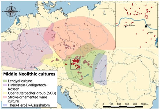
Figure 1.
Distribution of the KGAs (signified by red dots) in Central Europe and the Austrian core area in relation to the archaeologically defined cultural groups (LBI ArchPro).
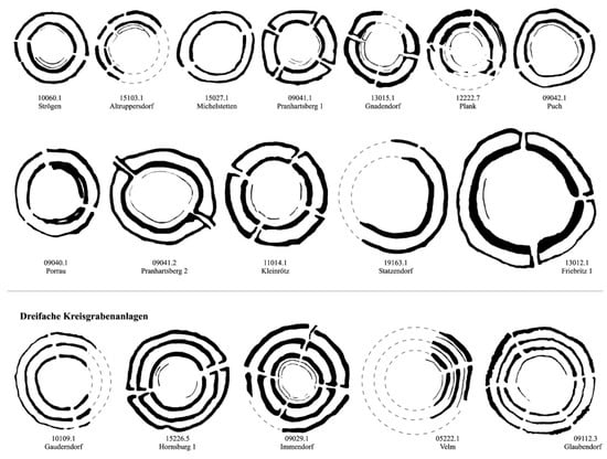
Figure 2.
Maps of selected KGAs in Austria exemplifying the diversity of the layouts [5].
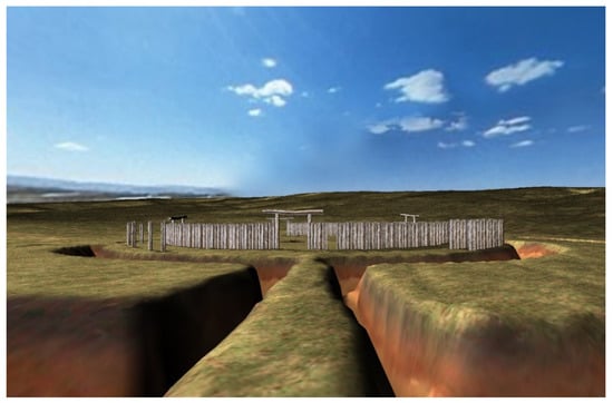
Figure 3.
Virtual reconstruction of the KGA at Steinabrunn ([2] Figure 3.2.1_01).
The monuments were probably associated with ritual and festive events. Deliberate astronomical orientations of the entrances have been discussed and interpreted to suggest that the monuments had a calendrical function or might have even been used as astronomical observatories [15,16,17]. They might also have been used for the legitimation of cultural or social patterns through natural phenomena. Their similarity and close contemporaneity across their distribution are unique in prehistory, perhaps representing the earliest found trans-cultural tradition of major public rituals, and they are presumed to be part of the phenomenon of social control, marking the earliest conscious attempt at pan-European socio-economic and ideological integration. This process, attested by the appearance of the KGA phenomenon, emerged rapidly and then abruptly ceased throughout Central Europe in a defined timespan of not more than 200–300 years.
In the rest of this paper, we focus on one example of these KGA monuments: the KGA site of Velm (Lower Austria), situated approximately 20 km south of Vienna, which was first documented in spring of 2001 by aerial photographs. The photographs show clear cropmarks of a triple KGA with three concentric timber palisades. After discovery, the site was investigated using various magnetic prospection systems. The aerial photographs and the first magnetograms clearly show that the monument has three massive ditches, which have a maximum diameter of 114 m and a width of up to 5.5 m, as well as three palisade rings, each running concentric to the ditches and adjacent dwellings [5] (p. 360).
Velm has a special characteristic compared to the many known KGA monuments. In most monuments with multiple ditches, the palisades are restricted only to the free inner space, enclosed by the innermost circle ditch. In the case of Velm, however, each of the three circular ditches shows its own palisade, which in previous monuments was interpreted as a sign of a temporal sequence of an expanding monument. Its atypical location outside the loess regions on a gravel plain in close proximity to a meandering river system led to the assumption that this was not one of the Middle Neolithic monuments.
Systematic magnetic prospection on several Austrian KGA’s has shown that these monuments can be explored in detail by high-resolution magnetic field measurements because the filling layers in the ditches, palisade ditches and postholes have a significantly higher magnetic susceptibility than the surrounding natural subsoil. The good magnetic prospectivity is enhanced by the fact that the original chernozems have been affected by heavy soil erosion due to intensive agricultural use [2]. Many of the KGA sites situated on slight slopes already show soil erosion down to the parent C horizon, which also explains their good visibility. Attempts to obtain further information by ground-penetrating radar (GPR) have shown that the monuments built in loess soils do not form corresponding contrasts in GPR, which is due to the similar grain sizes, the comparable pore volume and the very similar water capacity of the fill layers, respectively, compared to the surrounding natural soil.
The specific location of the KGA Velm on a sand and gravel plain promised favorable conditions for the application of ground-penetrating radar (Figure 4). The dry weather conditions in summer 2016 made it possible to conduct successful high-resolution surveys of the site using two motorized GPR systems [18]. The results of the radar measurements were extremely surprising. Not only could the ditches of a KGA be resolved in three dimensions for the first time, but reflections could also be seen in the palisade ditches as well as in an adjacent dwelling, which made it possible to identify each single post in the radargrams [19] (pp. 270–272).
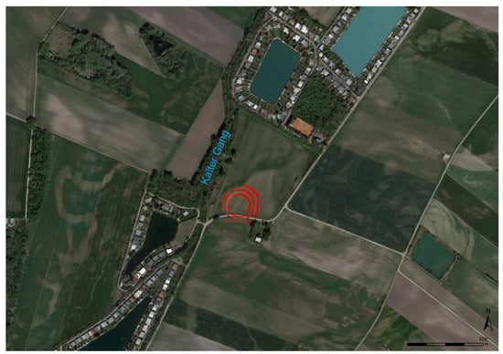
Figure 4.
A photomontage of two aerial photographs from GoogleEarth (04/2018 and 04/2019, http://www.earth.google.com, accessed on 23 April 2022) showing the Middle Neolithic KGA Velm (highlighted in red) surrounded by paleomeanders. Nowadays, the regulated course of the nearby river Kalten Ganges flows in a lowland, only a few meters to the west.
The following section describes the research process, which was designed to investigate these surprising results. Targeted drillings and a subsequent targeted archaeological excavation were conducted to verify whether the unusual KGA of Velm was in fact a Middle Neolithic monument, whether the archaeological structures recognized in the radargrams could be recovered, and finally, to find an explanation for the unusual appearance of individual posts in the GPR visualizations.
After a detailed description of the range of methods used during our research, the results for each method are presented and then synthesized.
2. Materials and Methods
2.1. Aerial Photography
The KGA of Velm was discovered on the 13 June 2001 during an archaeological reconnaissance flight taking observer-directed oblique aerial photographs (Figure 5). At this time, conditions were ideal for vegetation marks. As a result, the three ditches of the site with their accompanying palisade rings and parts of at least two houses of an outlying settlement appeared as distinct, green, positive vegetation marks against a yellow background of already ripening cereal plants. While circling around the site, ten photographs were taken from different observer positions using an analogue medium format camera (Hasselblad) loaded with slide film. When the images were inventoried into the GIS-based database of the Aerial Archive of the University of Vienna, it turned out that the site had already been documented on vertical photographs taken by the aerial reconnaissance of the Austrian Armed Forces in June 2000. The vertical images were made on black and white film at a scale of 1:15,000.
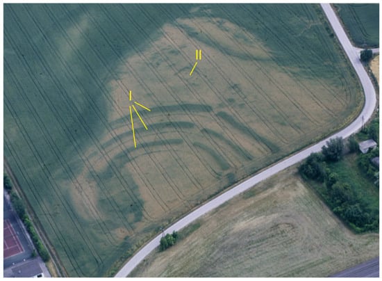
Figure 5.
Oblique aerial photograph from June 2001 showing positive vegetation marks of the KGA’s ditches and palisades as well as remains of at least one building. The Roman numerals refer to the archaeological interpretation noted in the text. I—the three ditches of the KGA, II—building (Luftbildarchiv, IUHA, Universität Wien, No.: 0120010603.050).
The vertical image pair had an overlap of 60%, which facilitated a photogrammetric aerial photo analysis. This was realized in 2004. At that time, both analytical and digital methods were used. To create a digital terrain model (DTM) of the area, the vertical stereopair was oriented using the analytical plotter DSR14 (KERN-WILD-LEICA) with control point information, which had been measured in the field by a total station. The DTM was measured in the form of a regular raster of 3D terrain points accompanied by 3D break line information (see also [20]). Both digitized vertical images and oblique photographs were then orthorectified using ERDAS Imagine Orthobase. The resulting orthophoto has a cell size of 0.2 m with a positional accuracy between ±0.25 m (vertical images) and ±0.5 m (oblique aerial photographs).
2.2. Cesium Gradiometer Magnetometry
The initial magnetic survey was carried out in 2003 using a handheld Archeo Prospections® multi-sensor cesium-magnetometer device [21] covering an area of 1.87 ha. The survey was part of a research project for the systematic magnetic prospection of all known Middle Neolithic KGAs in Austria by the Central Institute for Meteorology and Geodynamics (ZAMG), in cooperation with the Vienna Institute for Archaeological Science (VIAS) at the University of Vienna [5]. Five cesium sensors were mounted 0.35 m above ground with a sensor spacing of 0.5 m on a non-magnetic cart. A reference sensor was placed 2.85 m above ground above the second sensor. The data were taken at intervals of 0.1 s, with an accuracy of 0.005 nT, and were resampled on a regular grid of 0.125 m × 0.125 m. The positioning of the acquired dataset was performed by a terrestrial survey of the grid-corners using a total station. The data were automatically corrected for systematic and non-systematic errors [22] and were visualized as digital images, georeferenced and interpreted archaeologically in the GIS software package ArcView, as described elsewhere [21].
The magnetogram [5] (p. 360) (Figure 6A) is affected by disturbances of numerous anomalies caused by iron parts in the arable layer, iron fences, a traffic sign and a pipeline running under the modern road. Extensive geological structures can be seen in the survey area. The initial interpretation showed that the KGA has a maximum diameter of 114 m, but only a quarter of it is preserved. The width of the outermost ditch varies between 3 and 5 m. The middle ditch has a maximum diameter of 88 m, and the ditch widths vary between 3 and 5.5 m. The inner ditch has a maximum diameter of 64 m, and the ditch widths vary between 2.5 and 5 m. Between the ditches and in the interior, three concentric palisades with diameters of 106, 80 and 52 m are evident. The three ditches have at least one continuous entrance to the northeast. Outside the KGA, pit complexes, pits and postholes are recognizable. The structures cluster in the northeast of the KGA. They were interpreted as settlement remains that could not be observed in this form in connection to any other KGA in Austria. Dwellings with dimensions of 8 m × 13 m, 6 m × 11 m and 8 m × 15 m could be recognized.
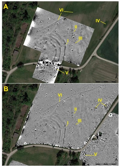
Figure 6.
Comparison of the two magnetometer surveys at Velm: (A) the cesium gradiometer survey from 2003, and (B) the motorized fluxgate gradiometer survey conducted in 2015 (both with clip-off values −4 nT to +6 nT). The Roman numerals refer to the archaeological interpretation noted in the text. I—entrance area to KGA, II—building, III—second building, IV—extraction pits, V—modern debris, VI—ditch for modern water management.
2.3. Motorized Fluxgate Gradiometer Magnetometry
In October 2015, a motorized magnetic survey by the Ludwig Boltzmann Institute for Archaeological Prospection and Virtual Archaeology (LBI ArchPro), using 8 Foerster FEREX CON650 gradiometer probes with a line-spacing of 25 cm mounted onto a 6 m-long custom-built measurement cart, was conducted to re-survey the area of the prehistoric monument. Survey positioning was performed by a base/rover solution (JAVAD Triumph 2) using RTK GNNS correction with an average accuracy of 5 cm. The survey area was hereby extended to include the closer vicinity of the KGA, focusing on a possible extension of the already known settlement structures. In total, an area of 14.4 ha was mapped, and the acquired data were processed in the LBI ArchPro/ZAMG internal software AP-soft [23].
The motorized fluxgate survey mapped almost the same archaeological structures as the manual cesium magnetometer survey from 2003 (compare Figure 6A,B). The only recognizable difference lay in the scattered dipole anomalies caused by small iron artifacts. These objects must have been very shallow within the topsoil and were moved by plowing during the period between the two surveys.
None of the magnetometer surveys showed the western and southern parts of the KGA. This might be due to erosion of the upper layers of the ditches by the river Kalter Gang or could be explained by the groundwater level in the floodplain, which dissolved the fine-grained magnetic minerals in the ditch fill, thus destroying the magnetization observed in the more elevated areas adjacent to the floodplain [24] (p. 137). The magnetic anomalies of the ditches show different levels of magnetization in the ditch fill. For example, the anomalies at the ditch terminals at the entrance indicate deposits with enhanced magnetization, suggesting a greater depth of the ditch. Finally, the magnetic data clearly show a building (Figure 6A,BII) with a typical megaron-like layout, typical for houses of the Middle Neolithic Lengyel culture, thus indicating contemporaneity with the KGA.
2.4. Motorized GPR Survey (SPIDAR)
Due to the expected suitable geological conditions, a first GPR survey was conducted by the LBI ArchPro in July 2016. The freshly harvested field provided perfect conditions for a motorized survey using a Sensors and Software SPIDAR 500 MHz system towed by an ATV. The six 500 MHz PulseEkko PRO GPR antenna pairs were mounted with a line-spacing of 25 cm and produced an inline-measurement every 5 cm, and positioning was again performed by base/rover solution (JAVAD Triumph 2) with RTK GNNS correction. During one day of fieldwork, an area of 1.7 ha was covered.
The GPR data were processed with the specialist software ApRadar developed over the past ten years by the ZAMG and the LBI ArchPro. A standardized GPR pulse velocity of 10 cm/ns has been assumed, corresponding to a dielectric constant or relative dielectric permittivity of 10. The following processing steps were applied: position assignment using a constant time delay to account for the inherent latency of the system, data alignment, adaptive time-zero correction, frequency band-pass filtering, average trace removal calculated along 20 m windows, weak stripe removal, inline data binning, grid mapping and interpolation, trace interpolation along 1 m windows and gain correction. A 2D migration with a velocity model decreasing from 12 cm/ns at the surface to 10 cm/ns at 40 ns was applied to focus the scattered energy as well as a Hilbert transformation for the GPR trace envelope calculation [17].
The visualizations of the GPR survey showed unexpected results. For the first time, clear indications of the continuation of the palisade constructions to the west and south became visible even in areas where other archaeological prospection methods were not able to map these structures. The impressive contrast between the highly reflective geological background and the absorbing archaeological structures (refilled ditches, palisades, foundation trenches and even single postholes) revealed detailed 3D information with a resolution of 25 cm × 5 cm up to a calculated depth of 180 cm (Figure 7A).
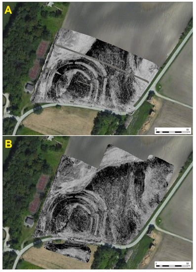
Figure 7.
Comparison of the two GPR surveys at Velm: (A) the motorized GPR survey with a 6-channel Sensors and Software SPIDAR 500 MHz, and (B) the motorized GPR survey with a 16-channel 400 MHz MIRA system from Malå (both showing a calculated depth range of 60 to 120 cm).
The high level of detail and the suitable ground conditions led to the decision to conduct a second GPR survey with an even higher spatial resolution, using a MIRA system.
2.5. Motorized GPR Survey (MIRA)
This second GPR survey, using a motorized system comprising a 16-channel 400 MHz MIRA system from Malå, mounted in front of a Kubota mini tractor, was conducted in September 2016. Due to the diagonally displaced arrangement of the antennas, a measurement resolution of 8 cm × 4 cm was achieved. To ensure that the high-resolution survey was also correctly georeferenced, positioning was again performed using a basis/rover solution (JAVAD sigma 3) and RTK GNNS correction with an average accuracy of less than 5 cm.
The surface conditions of the field were again very suitable for the motorized survey and the weather was very similar to the first GPR survey conducted only a couple of months earlier. Data quality was also enhanced by soil conditions at the time of survey: a long dry period was interrupted by a day of heavy rainfall. This meant that after a few days, the natural drainage of the soil was almost perfect for GPR measurements [25] (p. 218). To retrieve even more information from the archaeological structures, the orientation of the survey was turned 90°. Again, only one day of fieldwork was conducted, resulting in a surveyed area of 2.6 ha.
The dataset was processed with the same processing steps in the above-mentioned ApRadar software. As a result, georeferenced grayscale images were produced, representing calculated depth layer images of 5, 10 and 20 cm in thickness (Figure 7B).
2.6. Targeted Percussive Core Drilling
By targeted percussive core drilling, it is possible to gain a microinvasive insight into the stratigraphic nature of the site. A metal cylinder, driven into the ground, was used to recover a continuous and as far as possible undisturbed sequence of layers of sediments. Integrated PVC tubes inside the cylinders were used to store the retrieved samples for further analysis in a controlled environment. This method allows to drill and study strata buried under several meters of sediments, providing information which is not in the range of other non-destructive prospection methods such as magnetometry or GPR [26].
2.7. Archaeological Excavation
Based on the results of the geophysical surveys, an interdisciplinary archaeological excavation was carried out in 2019. In cooperation with the Institute of Prehistoric and Historic Archaeology (University of Vienna, Wien, Austria), VIAS and the LBI ArchPro investigated parts of the outer ditch and the outer palisade of the circular ditch monument as well as the nearby dwellings. The targeted excavation was carried out according to the stratigraphic excavation method of Harris [27]. In the excavation process, the individual deposits are removed in the reverse order of their formation and recorded with all their physical and spatial characteristics and stratigraphic relations [28]. The recorded units of stratification (deposits and surfaces) were compiled into a Harris Matrix using the HMC+ software, developed at the LBI ArchPro [29].
The individual surfaces revealed by removal of the overlying deposits at each stage of the excavation were digitally documented by image-based modeling (IBM), using photogrammetric and computer vision-based approaches. In this highly accurate documentation method, the exposed surfaces were documented by photographs and transformed into a digitized surface model using Structure from Motion and Multi-View Stereo algorithms (Metashape professional by Agisoft) that are at the core of such hybrid 3D modeling pipelines [30,31].
3. Results and Discussion
The archaeological interpretation process of multiple prospection datasets is one of the most important but also complex tasks within the spatial and temporal analysis of archaeological monuments based on archaeological prospection data. Conventionally, every method is interpreted separately, and a combined interpretation is derived via different combinations of the individual results from the various applied methods. Since the beginning of the re-investigation of the Neolithic KGA at Velm, it was the goal of the LBI ArchPro to improve not only the geophysical prospection methods themselves, but also the integrated interpretation of multiple archaeological prospection datasets. Only by combining the advantages of the different prospection methods can the available archaeological data be appropriately understood [32,33].
3.1. Archaeological Interpretation of Aerial Photographs
As mentioned above, the aerial photographs from the years 2000 and 2001 revealed extraordinarily detailed cropmarks, showing three ditches and a triple-palisade circular enclosure with two entrance corridors (see Figure 5). In the near vicinity of the ditch monument, traces of rectangular buildings, at least one with two rooms, and central posts were clearly visible. On a larger scale, the vertical images reveal vegetation marks of an abundant network of paleo-rivers (see Figure 4), which were also mapped to provide the paleo-environmental context to the interpretation of the site.
The terrain slopes towards the west by several meters. Here, it seems that the neighboring river (Mühlbach or Kalter Gang) has already eroded a large part of the gravel plain, and thus major areas of the Neolithic monument have probably fallen victim to natural erosion. However, another reason for the absence of vegetation marks could be a much better water and nutrient supply for the plants in the area near the river, thus minimizing the contrast in vegetation development between archaeological infills and natural sediments.
3.2. Archaeological Interpretation of Magnetometry Surveys
While the stronger magnetized areas of the three massive concentric ditches are clearly visible in the grayscale visualizations, the palisade structures only show up as faint linear anomalies. An entrance passage towards the northeast can be clearly recognized as a gap within the ditches. Unfortunately, the magnetometry survey did not show any details of the monument to the west and south (see Figure 8, and I in Figure 6A,B).
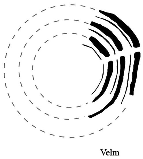
Figure 8.
Archaeological interpretation of the magnetometer surveys in 2003, showing the three ditches and palisades of the KGA—dashed lines represent an idealized reconstruction [5].
A small rectangular structure of 8 m × 8 m with a central pit and two adjoining linear anomalies pointing southwards were already recognized by aerial photos (II in Figure 5), as well as in the magnetometer surveys (II in Figure 6A,B). A second rectangular building with 8 m × 20 m, possibly formed by two similar parts with two central postholes each, was again identified—slightly tilted—to the southeast (III in Figure 6A,B). These rectangular structures are interpreted as dwellings, and although the general appearance allows dating them to prehistory, no exact period can be determined from the prospection data.
Further large, roughly rectangular anomalies within the survey area were already recognizable in the aerial monitoring (IV in Figure 6A,B). These structures were interpreted as gravel and sand extraction areas, but their temporal relation to the circular ditch monument is so far not known.
By talking with the landowners, further areas with a high density of dipole anomalies were identified as modern deposits of household debris, consisting of burned bricks and smaller iron objects (V in Figure 6A,B).
3.3. Archaeological Interpretation of GPR Surveys
Ground-penetrating radar is mostly used on sites where archaeological structures built of stone are expected. This is because stone structures such as masonry, road pavements or highly compacted floors produce highly reflective surfaces, which usually create a good contrast with the surrounding soils [33,34,35,36,37]. At Velm, the initial situation is exactly the opposite; here, the geological background is formed by several layers of gravel and sand deposits into which the archaeological structures have been cut. In this way, a strong contrast between geology and archaeology emerges, revealing the archaeological features as bright inlays into the dark subsoil (see Figure 7).
3.3.1. The Ditches
The three massive ditches forming the main features of the monument are clearly visible within the GPR dataset (see Figure 7). Even though the outer ditch was damaged by erosion from the nearby river, four entrance corridors can now be clearly identified. While the entrance to the northeast was known from the aerial and geomagnetic surveys, the entrances in the north and southeast were only recognizable in some of the aerial photos (2001, 2016). The corridor forming the southwestern entrance was so far only visible within the GPR data (see Figure 9).
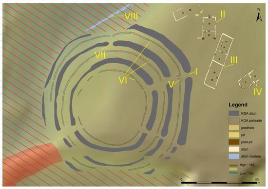
Figure 9.
Archaeological interpretation of the GPR surveys in 2016, showing the position of the KGA on the slightly elevated gravel plain. The Roman numerals refer to the archaeological interpretation noted in the text. I—entrance area to KGA, II—building, III—second building, IV—third building, V—L-shaped palisade terminal, VI—the three palisades of the KGA, VII—northern entrance are, VIII—ditch for modern water management. Area hashed in dark orange indicates the floodplain of the river Kalter Gang. The area in red (bottom left) shows the embankment of a modern road.
Another interesting detail of the monument lies in the construction of the northern entrance. While all the other entrance passages show a clear gap through all the three concentric ditches and palisades, the northern entrance has this gap only in the central and outer palisade, and presumably in the outer ditch. This construction detail might be an indication of at least two building phases. Here, the ditch is showing an entrance gap, but in the corresponding palisade, no interruption can be recognized. In short, the immediate access to the interior from the northern entrance was initially blocked by the central palisade (VII in Figure 9).
The erosion caused by the nearby river to the west revealed another construction detail of the outer ditch. At the truncated ridge of the gravel plain, the GPR data indicate a V-shaped ditch profile typical for KGAs, a significant detail that was later confirmed by the archaeological excavation (see Section 3.4.1).
3.3.2. The Palisades
The high resolution of the visualizations (10 cm × 10 cm) derived from the GPR survey revealed further fascinating details on the prehistoric monument. While the SPIDAR survey already showed the ditches of the individual palisades, the MIRA survey was able to visualize traces of single postholes within the palisades. Now, for the first time, not only was the foundation ditch that once held the palisade visible (VI in Figure 9), but this survey also showed traces of single timber posts from the Middle Neolithic palisade itself. More specifically, within the highly absorbing infill of the palisade ditch, isolated, roundish, highly reflective anomalies appear at a depth of 60 to 80 cm. We will address the cause for these distinctive anomalies—interpreted as posts—in the following section.
Another construction feature known from archaeological excavations at KGAs elsewhere [38,39] are massive posts at the terminus of the palisade. The traces of this—usually reinforced—post are clearly visible within the GPR data. In the case of the central palisade, even L-shaped termini forming an elaborate entrance passage are observable (V in Figure 9).
3.3.3. The Building
The construction detail described from the palisade was also observed within the nearby house structure (II in Figure 9). Although the rough appearance of the building was already known from previous non-destructive prospection methods (aerial photography and magnetometry), no further details on the construction were known. The high-resolution GPR visualizations showed that the wall of the ‘main room’ is formed by exactly the same anomalies as the palisades of the nearby KGA, indicating contemporaneity. The subsequent archaeological excavations confirmed that the postholes contained calcareous precipitates or concretions, created by multiple changes in groundwater level, and which could be recognized in the GPR data as the former wall of the building was constructed by single wooden posts set within single postholes or a narrow foundation ditch. Due to the multiple changes in the groundwater level, calcareous precipitates or concretions occurred inside the refilled postholes. These concretions could be recognized in the ground-penetrating radar as round, strongly reflecting areas, which are clearly separated from their geological surroundings.
While the postholes of the ‘annex’ to the south are formed by more stable, higher reflective anomalies, the wall construction of the main room seems to be somehow different. This observation might indicate two different construction techniques or building phases. These apparent construction differences could not be clarified by the analysis of non-destructive prospecting methods alone, and therefore this building was also selected for an archaeological excavation.
In the aerial, magnetometry and GPR surveys, a second building (IV in Figure 9) of the same construction design could be identified. It is located only a few meters to the east, but with a clearly rotated orientation. The third house-like structure (III in Figure 9, III in Figure 6) was already perceived in the aerial photographs as a faint ditch structure, but its detailed construction could only be recognized from the GPR.
3.3.4. Recent Structures
The higher magnetized linear structure (VI in Figure 6A,B and VIII in Figure 9) running a couple of meters north of the monument, from the southwest to the northeast, is now also visible within the whole extent of the field. In the northeastern corner, the structure splits into three individual branches, roughly following the contour lines. Integrating the information gathered from all conducted surveys leads to the interpretation of a ditch structure. A temporal connection to the nearby Neolithic monument was always argued, but never proven. However, the extended archival research brought a more recent usage of the ditch to light. On one of the first maps from the region, the Franzisco-Josephinische Landesaufnahme from 1869 to 1887, an extensive water-management system is clearly visible. On two older maps from this area, this structure was not documented. Therefore, the dating of this ditch can be fixed to the end of the 19th century.
3.4. Archaeological Excavation
The stratigraphic excavation process was documented digitally in three dimensions using the photogrammetric method of IBM [30,31], providing a detailed dataset for the comparison of the excavation results with the 3D GPR visualizations. The archaeological features uncovered during the excavation corresponded significantly with the visualization of the GPR data (Figure 10). Not only in terms of the position and dimensions of the larger archaeological features, but also for the majority of the smaller postholes, which formed the wall of the Neolithic house, and which had already been recognized in the prospection data. Furthermore, the anomalies detected in the GPR fit well with the 3D shapes of the excavated features. In other words, significant correspondence in both vertical and horizontal directions.
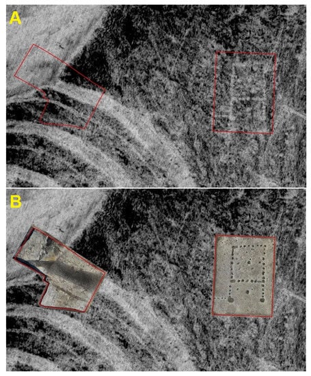
Figure 10.
(A) Visualization of the GPR dataset (depth range 60–140 cm) with the locations of the two excavation trenches (red frames). (B) The two orthophotos of the excavation trenches placed over the GPR dataset, showing perfectly coinciding investigation methods.
3.4.1. Excavation Trench 1—The Outer Ditch of the KGA
Through the stratigraphic excavation of the outer ditch, a total of 19 different deposits were identified in the refilled ditch. Of particular interest during the excavation was the shape of the bottom of the ditch. Typically, these ditches are up to 4 m-deep and are V-shaped with pointed bottoms, but in this case, it was only about 2 m-deep with a shallow U-shaped end. The reason for this is probably the high groundwater level, which caused problems during construction (Figure 11).
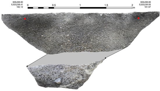
Figure 11.
Photographic documentation of the profile of the outer ditch at KGA Velm. Due to safety reasons, the ditch was excavated in two steps, and the gray area indicates this interruption. The red dots indicate the position of coordinates.
During the excavation, a sample from one of the lower deposits of the ditch was taken for radiocarbon dating. This provided a date of ca. 4725–4553 BC (VERA-7002).
During the excavation of the palisade, several strongly compacted layers of fine sands and clays were revealed. These compacted sediments were most probably caused by the remains of single timber posts, formed by calcareous precipitation during a changing groundwater level. This kind of palisade construction was also observed during the excavation of a very comparable Neolithic circular ditch monument at Steinabrunn in 1998 [40] (Abb. 2.29). Here, the 25–30 cm-thick posts were set in a narrow ditch with a mean width of 70 cm. The posts themselves were placed very close together at different depth levels.
By comparing the excavation results with the GPR dataset, it became evident that these congregations must be the source of the highly reflective structures from the GPR data. These concretions appear to be the calcified remains of the former timber posts.
3.4.2. Excavation Trench 2—The Neolithic House
The Neolithic house located in trench 2 was completely excavated and revealed a total of 36 postholes, some of which were placed in foundation ditches. Based on the construction technique and the numerous finds within the pits, the house can be dated to the Lengyel culture, to the period between ca. 4650 and 4550 BC (Figure 12) [11] (p. 130), [39] (p. 762), [41,42]. This dating was confirmed by two radiocarbon samples derived from animal bones which were recovered from deposits of the large terminal postholes of the building (4688 BC (95.4%) 4499 BC (VERA-7000) and 4706 BC (95.4%) 4547 BC (VERA-7001)).
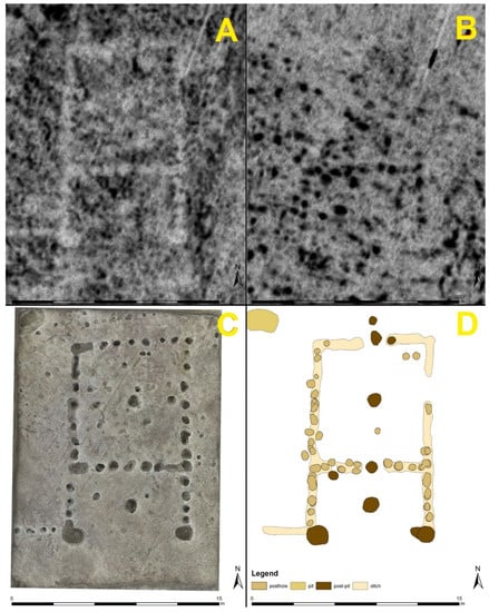
Figure 12.
Comparison of GPR datasets for the area of trench 1 ((A) depth range 60–100 cm, (B) depth range 140–170 cm), showing the different responses of the postholes. (C) The orthophoto generated by IBM during the excavation, and (D) archaeological interpretation of the GPR data before excavation.
The differences in the reflective properties of the two rooms, which were evident in the GPR, could also be observed during the excavation. Thus, it could be observed that the posts of the main (northern) room were predominantly set in a continuous wall trench, whereas the walls of the antechamber to the south were formed by single postholes. These postholes have an average diameter of about 60 cm and were backfilled with the excavated material after the wooden post was placed. In the GPR data, the postholes appear as absorbing areas enclosing a strong reflecting central anomaly. In this respect, the structure postulated from our surveys perfectly matches the observations made during the excavation (see Figure 10).
3.5. Integrated Data Interpretation
The surroundings of the KGA and the associated settlement are characterized by a depression in far older gravel formations. This depression is located between the rivers Triesting and Piesting, which have since been diverted. The depression itself is characterized by the river Kalter Gang. The Kalter Gang is a river that feeds from several groundwater sources over a few kilometers in the area southwest of the KGA and is notable for its particularly cold water. Today, it is canalized and straightened in its path and used as a mill stream (Figure 13).
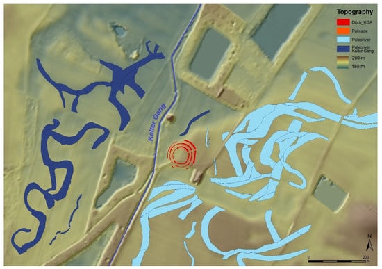
Figure 13.
The digital elevation model of the surroundings of the KGA Velm showing the depression generated by the erosion of the river Kalter Gang (dark blue). The system of paleo-rivers to the east must have been part of an older river system (light blue).
In prehistoric times, however, the Kalter Gang may have repeatedly flooded the depression and meandered strongly, triggered by periodically large bursts of water. Core samplings and excavations have shown that the Kalter Gang probably eroded the older gravel deposits post-glacially to a massive extent. The present depression, which can be traced well in the terrain data (see also DTM, Figure 9), is probably due to the river Kalter Gang.
Remains of organic layers were uncovered during the excavation under younger gravel deposits of the Kalter Gang to the north of the outer ditch of the KGA. Radiocarbon dates obtained from these organic deposits indicate that this area of the river depression was, after the post-glacial depression, an oxbow lake with slow-flowing to stagnant water in the period 9900 to 7100 BC. At the time of KGA construction, the active river channel probably ran slightly west of the KGA. A dense floodplain forest can be expected, which could have provided mainly willows, alders and ash trees as resources for the construction of the KGA and the settlement. It can be assumed that the floodplain forest was thinned out very quickly, either by the need for construction timber or by clearing for agriculture, and provided easy access for domestic animals, mainly cattle, to water. The humus layer on the gravel plains is very thin and less suitable for arable farming than the loess plains along the Wienerwald to the west. Therefore, grasslands and pasture are expected to have been the main basis for the settlement and respective large herds of cattle.
The excavation of the outer ditch has shown that the ditch was minimally re-dug three times and does not show the typical V-shaped ditch bottom but shows a U-shape at its base. This can be explained by the fact that during the construction of the KGA, the groundwater level was reached at this depth and further deepening of the trench was not feasible. The GPR measurements show that large sections of the palisade trench are characterized by individual postholes. Different sections of the interpreted GPR data show that the posts were not placed aligned and close to each other in the trench but were found offset to each other. This proves that the palisade was designed in such a way that the mutually offset posts resulted in an opaque timber wall.
After abandonment of the KGA, the ditches slowly infilled. With the beginning of the Iron Age, it is likely that the Kalter Gang again periodically carried more water. As a result, the western and southern parts of the KGA were eroded by periodic flooding or episodes of increased river flow. The traces of erosion are clearly visible in the GPR data and could be confirmed by the excavation. After the erosion, a phase of accumulation followed again in the excavated area of the KGA. An Iron Age sherd was found in the deposits of the northern trench profile, just beneath the modern plough-soil, which indicates that the topography that was encountered during the surveys described here was likely formed by the end of the Iron Age.
4. Conclusions
Non-destructive exploration of extensive Neolithic archaeological sites is usually carried out either by aerial photography or by magnetic prospecting. The circular ditch site at Velm is a perfect example of the benefits of an integrated archaeological prospection strategy that combines different methods to ensure that all non-destructive information is collected before ground intrusive methods are carried out.
The particular topographic and geologic conditions at Velm clearly demonstrate that without combining the various prospection techniques, the circular ditch monument and its surrounding settlement could not be explored in their entirety. In the lower-lying areas to the west, no vegetation marks were visible on the aerial photographs, nor did the ditches to the west and south of the circular ditch complex show up in the magnetic surveys, suggesting that the KGA was either incomplete or might be atypical for this monument type. Only the GPR survey proved that Velm is a typical Middle Neolithic monument by providing clear images of the otherwise invisible western and southern parts of the monument. GPR also provided, for the first time, visualizations of anomalies of the individual wooden posts in the palisade and the houses.
There are not many cases where GPR surveys are followed by targeted excavations to verify the structures detected in the survey data. In the presented study, the anomalies identified from the non-destructive surveys could also be recognized and documented during the excavation. Of great interest for the analysis and interpretation of the GPR data was the description of their physical properties as well as their local extent and depth. In particular, the origin of the highly reflective areas within the postholes and palisades was one of the stated goals of the excavation. During the excavation, in some postholes, a calcareous hardening was found, forming the specific surface at which the electromagnetic wave was increasingly reflected back to the GPR receiver.
Due to the digital documentation of the excavation, it was possible to compare the results with the three-dimensional data of the GPR survey. Here, it became evident that a major part of the archaeological structures documented during the excavation were already identified in the interpretation of the non-destructive surveys. The excavation also clarified our questions on the construction, dating and state of preservation of the monument.
The additional knowledge gained from the excavation can now be extended to the entire monument, thus enabling a complete description of the prehistoric site. The integrated data analysis clearly showed that the understanding of the Neolithic site in its full complexity was only possible by combining all available methods.
Author Contributions
Conceptualization, M.W.; methodology, M.W., M.D., F.K. and W.N.; software, A.H.; investigation, M.W., M.D., I.K., F.K. and W.N.; writing—original draft preparation, M.W.; writing—review and editing, M.W., M.D., I.K., F.K. and W.N.; visualization, M.W.; funding acquisition, W.N. All authors have read and agreed to the published version of the manuscript.
Funding
This research was funded by the Marktgemeinde Himberg and the University of Vienna.
Data Availability Statement
Not applicable.
Acknowledgments
The authors would like to express their sincere thanks to the landowner Karl Bauer for his great support. Many thanks are also owed to Walter Karlik and Markus Waldburger for organizing and coordinating the investigations on site and to the Freiwillige Feuerwehr Velm for their active support during the excavation. We thank the team of the LBI ArchPro, namely Hannes Schiel, Tanja Trausmuth and Juan Torrejon Valdelomar, for their highly qualified work by acquiring the geophysical prospection data. We also want to thank the students from the University of Vienna—Constantin Hladik, Miriam Feichtinger, Fabian Benedict, Katharina Riederer and David Simböck, and our colleagues Roland Filzwieser and David Ruß—for supporting us during the excavation. The LBI ArchPro (archpro.lbg.ac.at) is based on an international cooperation of the Ludwig Boltzmann Gesellschaft (A), Amt der Niederösterreichischen Landesregierung (A), University of Vienna (A), TU Wien (A), Danube University Krems (A), ZAMG—Central Institute for Meteorology and Geodynamics (A), 7reasons (A), The Spanish Riding School Vienna (A), LWL—Federal state archaeology of Westphalia-Lippe (D), NIKU—Norwegian Institute for Cultural Heritage (N), and Vestfold and Telemark fylkeskommune—Kulturarv (N).
Conflicts of Interest
The authors declare no conflict of interest.
References
- Řídký, J.; Květina, P.; Limburský, P.; Končelová, M.; Burgert, P.; Šumberová, R. Big Men or Chiefs? Rondel Builders of Neolithic Europe; Oxbow Books: Oxford, UK; Philadelphia, PA, USA, 2018. [Google Scholar]
- Neubauer, W. Kreisgrabenanlagen (4850/4750–4650/4500 BC). In Erste Bauerndörfer–Älteste Kultbauten. Die Frühe und Mittlere Jungsteinzeit in Niederösterreich. Archäologie Niederösterreichs; Lenneis, E., Ed.; Verlag der Österreichischen Akademie der Wissenschaften: Wien, Austria, 2017; pp. 276–296. [Google Scholar]
- Petrasch, J. Die mittelneolithischen Kreisgrabenanlagen in Zentraleuropa: Forschungsstand und Interpretationstheorien zu Funktion und Bedeutung. In Neolithische Kreisgrabenanlagen in Europa—Neolithic Circular Enclosures in Europe, Proceedings of the Internationale Arbeitstagung, Goseck (Sachsen-Anhalt), Germany, 7–9 May 2004; Bertemes, F., Meller, H., Eds.; Sachsen-Anhalt Landesamt für Denkmalpflege und Archäologie: Halle (Saale), Germany, 2012; pp. 41–66. [Google Scholar]
- Neubauer, W. Kreisgrabenanlagen–Middle Neolithic Ritual Enclosures in Austria 4800–4500 BC. In Enclosing the Neolithic: Recent Studies in Britain and Europe; BAR International Series 2440; BAR Publishing: Oxford, UK, 2012; pp. 147–164. [Google Scholar]
- Melichar, P.; Neubauer, W. (Eds.) Mittelneolithische Kreisgrabenanlagen in Niederösterreich. Geophysikalisch-Archäologische Prospektion—Ein Interdisziplinäres Forschungsprojekt; Mitteilungen der Prähistorischen Kommission 71; Verlag der Österreichischen Akademie der Wissenschaften: Wien, Austria, 2010. [Google Scholar]
- Stäuble, H. Mittelneolithische Kreisgrabenanlagen im Wandel der Zeit–Die sächsischen Beispiele. In Vorträge des 25. Niederbayerischen Archäologentages; Schmotz, K., Ed.; Marie Leidorf: Rahden, Germany, 2007; pp. 169–184. [Google Scholar]
- Podborský, V. Praveká Sociokultovní Architektura na Moravě (Primeval Socio-Ritual Architecture in Moravia); Masarykova univerzita v Brně: Brno, Czech Republic, 1999. [Google Scholar]
- Nemejcová-Pavúková, V. Band 1-Zwei Kreisgrabenanlagen der Lengyel-Kultur; Studia Archaeologica et Mediaevalia 2; Katedra Archeológie Filozofickej Fakulty, Univerzity Komenského: Bratislava, Slovakia, 1995; (In Svodín). [Google Scholar]
- Trnka, G. Studien zu Mittelneolithischen Kreisgrabenanlagen; Mitteilungen der prähistorischen Kommission 26, Wien; Verlag der Österreichischen Akademie der Wissenschaften: Wien, Austria, 1991. [Google Scholar]
- Petrasch, J. Mittelneolithische Kreisgrabenanlagen in Mitteleuropa, Bericht der Romisch-Germanischen Kommission 71/1; von Zabern Propylaeum: Mainz am Rhein, Germany, 1990; pp. 407–564. [Google Scholar]
- Stadler, P.; Ruttkay, E. Absolute Chronology of the Maravian-Easter-Austrian Group (MOG) of the Painted Pottery (Lengyel-Culture) Based on New Radiocarbon Dates from Austria. In The Lengyel, Polgár and Related Cultures in the Middle/Late Neolithic in Central Europe; Kozłowski, J.K., Raczky, P., Eds.; Polish Academy of Arts and Sciences (Polska Akademia Umiejętności): Kraków, Poland, 2007; pp. 117–146. [Google Scholar]
- Limburský, P.; Řídký, J.; Šumberová, R.; Končelová, M. Radiocarbon dating in action. In Big Men or Chiefs? Rondel Builders of Neolithic Europe; Řídký, J., Květina, P., Limburský, P., Končelová, M., Burgert, P., Šumberová, R., Eds.; Oxbow Books: Oxford, UK; Philadelphia, PA, USA, 2018; pp. 103–134. [Google Scholar]
- Gibson, A. Monumente der Steinzeit. In Zeitreise Heldenberg. Geheimnisvolle Kreisgräben: Niederösterreichische Landesausstellung 2005; Daim, F., Neubauer, W., Eds.; Katalog des NÖ Landesmuseums NF 459; Berger: Horn, Austria, 2005; pp. 124–131. [Google Scholar]
- Řídký, J. Rondels—Structural elements, original appearance and construction. In Big Men or Chiefs? Rondel Builders of Neolithic Europe; Řídký, J., Květina, P., Limburský, P., Končelová, M., Burgert, P., Šumberová, R., Eds.; Oxbow Books: Oxford, UK; Philadelphia, PA, USA, 2018; pp. 67–102. [Google Scholar]
- Zotti, G.; Neubauer, W. Astronomical and Topographical Orientation of Kreisgrabenanlagen in Lower Austria. In SEAC 2011 Stars and Stones: Voyages in Archaeoastronomy and Cultural Astronomy, Proceedings of the SEAC 2011 Conference, Evora, Portugal, 19–22 September 2011; BAR International Series 2720; BAR Publishing: Oxford, UK, 2015; pp. 188–193. [Google Scholar]
- Zotti, G.; Neubauer, W. Astronomische Aspekte der Kreisgrabenanlagen in Niederösterreich. In Mittelneolithische Kreisgrabenanlagen in Niederösterreich. Geophysikalisch-Archäologische Prospektion—Ein Interdisziplinäres Forschungsprojekt; Melichar, P., Neubauer, W., Eds.; Mitteilungen der Prähistorischen Kommission 71; Verlag der Österreichischen Akademie der Wissenschaften: Wien, Austria, 2010; pp. 136–167. [Google Scholar]
- Schlosser, W. Astronomische Untersuchungen der Kreisgrabenanlage von Goseck. In Neolithische Kreisgrabenanlagen in Europa, Proceedings of theInternationale Arbeitstagung, Goseck (Sachsen-Anhalt), Germany, 7–9 May 2004; Bertemes, F., Meller, H., Eds.; Sachsen-Anhalt Landesamt für Denkmalpflege und Archäologie: Halle (Saale), Germany, 2012; pp. 389–394. [Google Scholar]
- Trinks, I.; Hinterleitner, A.; Neubauer, W.; Nau, E.; Löcker, K.; Wallner, M.; Gabler, M.; Filzwieser, R.; Wilding, J.; Schiel, H.; et al. Large-area high-resolution ground-penetrating radar measurements for archaeological prospection. Archaeol. Prospect. 2018, 25, 171–195. [Google Scholar] [CrossRef]
- Wallner, M.; Torrejón Valdelomar, J.; Trinks, I.; Doneus, M.; Neubauer, W.; Schiel, H.; Trausmuth, T.; Vonkilch, A.; Hinterleitner, A. Unique details on the structural elements of a Neolithic site in Velm, Lower Austria-the necessity of integrated prospection and visualisation in archaeological prospection. In Proceedings of the AP2017, Conference: 12th International Conference on Archaeological Prospection, Bradford, UK, 12–16 September 2017; Jennings, B., Gaffney, C., Sparrow, T., Gaffney, S., Eds.; Archaeopress Archaeology: Oxford, UK, 2017; pp. 270–272. [Google Scholar]
- Doneus, M.; Neubauer, W. 2D Combination of Prospection Data. Archaeol. Prospect. 1998, 5, 29–56. [Google Scholar] [CrossRef]
- Neubauer, W. Magnetische Prospektion in der Archäologie; Mitteilungen der Prähistorischen Kommission 44; Verlag der Österreichischen Akademie der Wissenschaften: Wien, Austria, 2001. [Google Scholar]
- Eder-Hinterleitner, A.; Neubauer, W.; Melichar, P. Reconstruction of archaeological structures using magnetic prospection. APL 1996, 28, 131–137. [Google Scholar]
- Hinterleitner, A.; Neubauer, W.; Trinks, I. Removing the influence of vehicles used in motorized magnetic prospection systems. In Proceedings of the 10th International Conference on Archaeological Prospection, Vienna, Austria, 29 May–2 June 2013; pp. 384–386. [Google Scholar]
- Faßbinder, J. Kastelle an der Grenze des Römischen Reiches-“Superspreader” im Magnetfeld: Drei Lager für den Sommer. Ber. Berichte der Bayerischen Bodendenkmalpflege 2021, 62, 133–137. [Google Scholar]
- Schmid, A.; Fry, R.; Parkyn, A.; Bonsall, J.; Gaffney, C. When the time is right: The impact of weather variations on the contrast in earth resistance data. In Proceedings of the AP2017, 12th International Conference of Archaeological Prospection, Bradford, UK, 12–16 September 2017; Jennings, B., Gaffney, C., Sparrow, T., Gaffney, S., Eds.; Archaeopress Publishing Ltd.: Oxford, UK, 2017; pp. 218–219. [Google Scholar]
- Köstelbauer, F. Geoarchäologische Untersuchungen Einer Neolithischen Kreisgrabenanlage bei Velm, Niederösterreich; Masterarbeit an der Universität Wien: Vienna, Austria, 2019. [Google Scholar]
- Harris, E.C. Principles of Archaeological Stratigraphy, 2nd ed.; Academic Press: London, UK, 1989. [Google Scholar]
- Neubauer, W. Laser Scanning and Archaeology–Standard Tool for 3D Documentation of Excavations. GIM Int. 2007, 21, 14–17. [Google Scholar]
- Neubauer, W.; Traxler, C.; Lenzhofer, A.; Kucera, M. Integrated Spatio-temporal Documentation and Analysis of Archaeological Stratifications Using the Harris Matrix. In Proceedings of the 16th Eurographics Workshop on Graphics and Cultural Heritage, Vienna, Austria, 12–15 November 2018; pp. 235–239. [Google Scholar] [CrossRef]
- Förstner, W.; Wrobel, B.P. Photogrammetric Computer Vision: Statistics, Geometry, Orientation and Reconstruction; Springer International Publishing: Cham, Switzerland, 2016. [Google Scholar]
- Doneus, M.; Verhoeven, G.; Fera, M.; Briese, C.; Kucera, M.; Neubauer, W. From Deposit to Point Cloud—A Study of Low-Cost Computer Vision Approaches for the Straightforward Documentation of Archaeological Excavations. In Geoinformatics 6, XXIIIrd International CIPA Symposium, Prague, Czech Republic, 12–16 September 2011; Faculty of Civil Engineering, Czech Technical University in Prague: Prague, Czech Republic, 2011; pp. 81–88. [Google Scholar]
- Doneus, N.; Neubauer, W.; Doneus, M.; Wallner, M. Die archäologische Landschaft von Halbturn. Ergebnisse aus drei Jahrzehnten integrierter archäologischer Archaeol. Austriaca 2018, 102, 201–226. [Google Scholar] [CrossRef]
- Wallner, M.; Löcker, K.; Gugl, C.; Trausmuth, T.; Vonkilch, A.; Einwögerer, C.; Jansa, V.; Wilding, J.; Pollhammer, E.; Neubauer, W. The ‘Archpro Carnuntum’ Project–Integrated Archaeological Interpretation of Combined Prospection Data, Carnuntum (Austria). Építés-Építészettudomány 2021, 49, 77–95. [Google Scholar] [CrossRef]
- Filzwieser, R.; Ivanišević, V.; Verhoeven, G.; Gugl, C.; Löcker, K.; Bugarski, I.; Schiel, H.; Wallner, M.; Trinks, I.; Trausmuth, T.; et al. Integrated Geophysical and Photographic Data to Visualize the Quarried Structures of the Roman Town of Bassianae. Remote Sens. 2021, 13, 2384. [Google Scholar] [CrossRef]
- Keay, S.; Parcak, S.H.; Strutt, K.D. High resolution space and ground-based remote sensing and implications for landscape archaeology: The case from Portus, Italy. JAS 2014, 52, 277–292. [Google Scholar] [CrossRef]
- Neubauer, W.; Wallner, M.; Gugl, C.; Löcker, K.; Vonkilch, A.; Trausmuth, T.; Nau, E.; Jansa, V.; Wilding, J.; Hinterleitner, A.; et al. Zerstörungsfreie archäologische Prospektion des römischen Carnuntum—erste Ergebnisse des Forschungsprojekts “ArchPro Carnuntum”. In Carnuntum Jahrbuch 2017; Verlag der Österreichischen Akademie der Wissenschaften: Wien, Austria, 2018; pp. 55–75. [Google Scholar] [CrossRef]
- Verdonck, L.; Launaro, A.; Vermeulen, F.; Millett, M. Ground-penetrating radar survey at Falerii Novi: A new approach to the study of Roman cities. Antiquity 2020, 94, 705–723. [Google Scholar] [CrossRef]
- Pavúk, J. Hausgrundrisse der Lengyel-Kultur in der Slowakei. In Archäologische Perspektiven: Analysen und Interpretationen im Wandel; Eckert, J., Eisenhauer, U., Zimmermann, A., Eds.; Festschrift für Jens Lüning zum 65. Geburtstag; Internationale Archäologie, Studia Honoria 20; Verlag Marie Leidorf: Rahden/Westf, Germany, 2003; pp. 455–469. [Google Scholar]
- Ruß, D. Ein mehrphasiger Siedlungs- und Bestattungsplatz auf der Trasse der Ortsumfahrung Jetzelsdorf (B 303), Niederösterreich. Fundberichte aus Österreich 2004, 43, 752–774. [Google Scholar]
- Fera, M.; Neubauer, W.; Rachbauer, O. Gut erhalten-neu erforscht. Die Kreisgrabenanlage von Steinabrunn. In Zeitreise Heldenberg. Geheimnisvolle Kreisgräben: Niederösterreichische Landesausstellung 2005; Daim, F., Neubauer, W., Eds.; Katalog des NÖ Landesmuseums NF 459; Berger: Horn, Austria, 2005; pp. 61–72. [Google Scholar]
- Lenneis, E.; Rammer, E. Häuser. In Erste Bauerndörfer–Älteste Kultbauten. Die frühe und Mittlere Jungsteinzeit in Niederösterreich. Archäologie Niederösterreichs; Lenneis, E., Ed.; Verlag der Österreichischen Akademie der Wissenschaften: Wien, Austria, 2017; pp. 270–275. [Google Scholar]
- Pavúk, J. Kolové stavby lengyelskej kultúry. Pôdorysy, interiér a ich funkcia. The Lengyel Culture Stockade Buildings. Ground Plans, Interior, and Their Function. Slovenská Archeologia 2012, 60, 251–284. [Google Scholar]
Publisher’s Note: MDPI stays neutral with regard to jurisdictional claims in published maps and institutional affiliations. |
© 2022 by the authors. Licensee MDPI, Basel, Switzerland. This article is an open access article distributed under the terms and conditions of the Creative Commons Attribution (CC BY) license (https://creativecommons.org/licenses/by/4.0/).