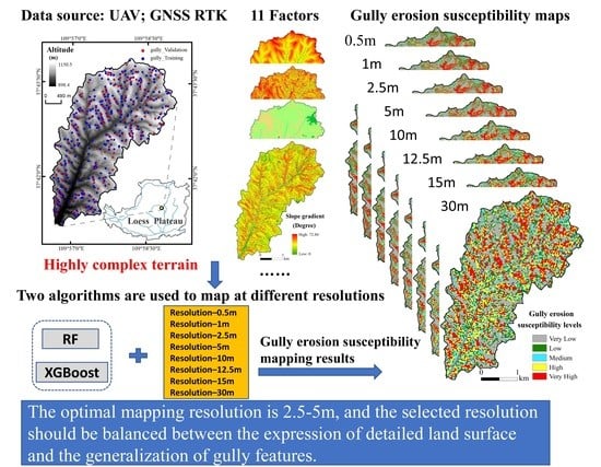
Choosing the Right Horizontal Resolution for Gully Erosion Susceptibility Mapping Using Machine Learning Algorithms: A Case in Highly Complex Terrain
 , ,
, , 
Abstract
Share and Cite
Yang, A.; Wang, C.; Yang, Q.; Pang, G.; Long, Y.; Wang, L.; Yang, L.; Cruse, R.M. Choosing the Right Horizontal Resolution for Gully Erosion Susceptibility Mapping Using Machine Learning Algorithms: A Case in Highly Complex Terrain. Remote Sens. 2022, 14, 2580. https://doi.org/10.3390/rs14112580
Yang A, Wang C, Yang Q, Pang G, Long Y, Wang L, Yang L, Cruse RM. Choosing the Right Horizontal Resolution for Gully Erosion Susceptibility Mapping Using Machine Learning Algorithms: A Case in Highly Complex Terrain. Remote Sensing. 2022; 14(11):2580. https://doi.org/10.3390/rs14112580
Chicago/Turabian StyleYang, Annan, Chunmei Wang, Qinke Yang, Guowei Pang, Yongqing Long, Lei Wang, Lijuan Yang, and Richard M. Cruse. 2022. "Choosing the Right Horizontal Resolution for Gully Erosion Susceptibility Mapping Using Machine Learning Algorithms: A Case in Highly Complex Terrain" Remote Sensing 14, no. 11: 2580. https://doi.org/10.3390/rs14112580
APA StyleYang, A., Wang, C., Yang, Q., Pang, G., Long, Y., Wang, L., Yang, L., & Cruse, R. M. (2022). Choosing the Right Horizontal Resolution for Gully Erosion Susceptibility Mapping Using Machine Learning Algorithms: A Case in Highly Complex Terrain. Remote Sensing, 14(11), 2580. https://doi.org/10.3390/rs14112580