Article

Distinct Variability between Semidiurnal and Diurnal Internal Tides at the East China Sea Shelf

1
CAS Key Laboratory of Ocean Circulation and Waves, Institute of Oceanology, Chinese Academy of Sciences, Qingdao 266071, China
2
Pilot National Laboratory for Marine Science and Technology, Qingdao 266237, China
3
Center for Ocean Mega-Science, Chinese Academy of Sciences, Qingdao 266071, China
4
University of Chinese Academy of Sciences, Beijing 100049, China
5
China-Asean College of Marine Science, Xiamen University Malaysia, Sepang 43900, Malaysia
6
CAS Engineering Laboratory for Marine Ranching, Institute of Oceanology, Chinese Academy of Sciences, Qingdao 266071, China
*
Author to whom correspondence should be addressed.
Remote Sens. 2022, 14(11), 2570; https://doi.org/10.3390/rs14112570
Submission received: 27 March 2022 / Revised: 11 May 2022 / Accepted: 19 May 2022 / Published: 27 May 2022
(This article belongs to the Special Issue Remote Sensing Applications in Ocean Observation)

Abstract

:
Breaking internal tides and induced mixing are critical to shelf dynamics, including heat and mass exchanges. Spatiotemporal variability of internal tides and modulation factors for the southern East China Sea shelf were examined based on a combination of a three-month mooring velocity and satellite altimeter data. Semidiurnal and diurnal internal tides exhibited distinct temporal trends, with the semidiurnal internal tides enhanced by an order of magnitude during the latter half of the record, while the diurnal internal tides followed quasi spring-neap cycles with a generally stable intensity except for two specific periods of strengthening. These internal tides probably originated remotely over the shelf-slope area northeast of Taiwan. Time-varying stratification was the most important factor for the internal tidal magnitude. In addition, varying background currents influenced the diurnal critical latitude band, which explains the slightly enhanced diurnal internal tides during the two periods. Although both semidiurnal and diurnal internal tides were mode-1 dominated, the semidiurnal internal tides were surface intensified while the diurnal tides were bottom intensified. The proportion of higher mode internal tides increased during robust eddy activities. Stronger background vertical shear corresponded to high-frequency events and energy transfers from tidal frequencies to high frequencies associated with turbulent mixing.

1. Introduction

Internal tides are generated when barotropic tides in a stratified water column flow over abrupt topography, such as a continental shelf edge, subsurface ridge, sill, or seamount [1]. Previous analysis indicates that open-ocean low-mode internal tides lose up to 60% of their energy as they impinge onto the continental shelf [2]. Along the continental margins, internal tides can induce turbulent mixing, playing a pivotal role in mass and heat transports, biological production, and possibly even shaping the continental slope [3]. Deciphering the formation, structure, and variability of internal tides at the continental shelf is of significance in understanding the coastal regions and their energy exchange with the open ocean.
Global maps of mode-1 internal tides have been estimated by numerical models [4,5] and satellite observations [6,7,8]. Nevertheless, some pieces are still missing over the continental shelves and in coastal regions, and the accuracy decreases near land. Accurately characterizing the internal tide is challenging for numerical models due to the highly variable stratification and complex topography. Noise contamination near land prevents internal tides from being identified in altimeter results in continental shelf areas [6,8,9]. All of these make in situ observations indispensable to accurately characterize internal tides in shallow coastal waters.
The East China Sea (ECS) is considered to be the second-largest M2 internal tidal generating site among global shelf regions, owing to the strong tidal currents that are perpendicular to the steep continental slope [1]. In the ECS, strong internal tides are effectively generated by multiple sources, including the Ryukyu Island chain, Tokara Straits, and the continental shelf break. Furthermore, these waves can propagate both onshore and offshore [10]. Previous studies primarily focused on offshore propagating tidal beams, particularly their propagation path, their complicated multiple-source interference patterns in the deep waters of the western Pacific Ocean [10,11,12], and the energetics and variability modulated by the Kuroshio at the mouth of a canyon northeast of Taiwan [13,14,15]. Synthetic Aperture Radar (SAR) images illuminated the manifestation of internal solitary waves northeast of Taiwan [16,17,18], an indicator of shoreward internal tidal activities. Consequently, inshore propagating internal tides from these strong sources and their influence requires further investigation over the inner continental shelf.
Temporal variation is a common feature of internal tides, with multiple factors leading to a range of time scales from days to several years. Time-varying stratification, both seasonal and by the spring-neap cycle, can significantly affect the energetics and turbulent dissipation of internal tides [19]. Seasonal variability of semidiurnal and diurnal internal tides in the northern South China Sea (SCS) are subject to changes in the corresponding barotropic tide in the Luzon Strait [20,21,22]. Over a longer interannual period, ENSO events affect the intensity and modal structure of diurnal and semidiurnal internal tides through stratification changes [23,24]. Background currents and eddies strongly modify the generation, propagation, and evolution of internal tides [25,26], by regulating the energy source [13], altering the phase speed of refraction [27,28], scattering to higher modes [29,30], adding relative vorticity to the system [31,32], and dephasing the internal tides, so they become nonstationary [33,34,35]. The ECS shelf features multi-scale subtidal frequency processes: the monthly changing Kuroshio front [36] and its intrusion branch [37], the seasonal varying Taiwan Warm Current [38], and vigorous eddies [39,40]. The temporal characteristics of internal tides under these complex dynamical processes over the ECS shelf remain unknown.
The ECS generates both semidiurnal and diurnal internal tides [10,41]. Although they share a similar generation mechanism, they differ in frequency, wavelength, and propagation directions, both horizontal and vertical. Numerical simulation results suggest that diurnal and semidiurnal tidal beams originating from the Luzon Strait are quite different in propagation paths and interference patterns [11,28]. The generation and propagation of internal tides are strongly latitude dependent [42]. Internal tides tend to resonate in the critical latitude zones and cannot freely propagate poleward of their critical latitude [31]. For diurnal internal tides, the critical latitudes for the O1 and K1 tides are 27.6° and 30°, respectively. Recently, the role of low-frequency flows has been recognized in modulating and broadening the impact range of critical latitudes [32]. Particularly, the southern ECS is located in the latitude range affected by the diurnal critical latitudes. Until now, there is no literature describing the diurnal internal tides in the ECS shelf region. The ECS, with its wide continental shelf with a steep continental shelf break and a time-varying background current, is a complicated region for internal tidal dynamics. The behavior of diurnal and semidiurnal tides, their different characteristics, and the exact impacts of the critical latitudes on diurnal internal tidal variability remains unknown.
Therefore, mooring observations combined with altimeter data for the ECS shelf region were employed to explore the vertical structure and temporal variability of internal tides. The contributions of the relative vorticity and stratification induced by background flow in modifying the temporal variations of semidiurnal and diurnal internal tides were assessed. The remainder of this paper is organized as follows: Section 2 describes the characteristics of the in situ velocities and satellite data, the background barotropic tides, and the methods used in this paper. Section 3 provides temporal variability of semidiurnal and diurnal internal tides. The source region and travel times of internal tides, the roles of stratification, and the relative vorticity associated with background conditions are discussed in Section 4. Section 5 summarizes the results and conclusions.

2. Materials and Methods

2.1. Mooring Observations

From 29 May 2014 to 2 September 2014, a mooring was deployed on the western ECS shelf. It was located at 26°35′N, 121°09′E, at a water depth of 72 m (Figure 1a). A nearly three-month-long time series was obtained from an upward-looking 300 kHz Acoustic Doppler Current Profiler (ADCP) mounted on the sea bottom. The vertical sampling interval was set to 2 m, with a time interval of 30 min. To eliminate near-surface contamination from noise reflection, the upper two layers of data were removed. Additionally, occasional isolated spikes were eliminated and replaced through interpolation. Thus, the depth ranges for the available current data ranged from 8 m to 68 m, with a precision of ±0.5 cm/s. Since nearly the entire water column was sampled, the barotropic current was defined as the depth-averaged flow. The residual baroclinic anomalies were determined by subtracting the barotropic velocities from the total velocities. Using a first-order Butterworth filter, these baroclinic anomalies were divided into 7-day low-pass sections, diurnal internal tides (frequency bound: (0.9, 1.1) K1), semidiurnal internal tides (frequency bound: (0.9, 1.1) M2). Tidal harmonic analysis was conducted on the velocity records to obtain the phase-locked internal tides using the UTide toolbox [43]. We also employed an empirical orthogonal function (EOF) method to characterize the detailed modal structure of the baroclinic signals. Although this method is based on data statistics, it can demonstrate a reasonable modal structure of baroclinic tides, and it is widely used in internal wave analysis [44,45,46]. Considering the variable stratifications and currents, we used 14-day moving overlapped EOFs to analyze the modal content.

2.2. Satellite Altimetric Data

To estimate the influence of background currents and sea level height variations on internal tides, gridded sea level anomaly (SLA) and geostrophic velocities were obtained from Archiving, Validation, and Interpretation of Satellite Oceanographic Data (AVISO). The delayed-time data are all satellite mission merged, produced by Ssalto/Duacs, and distributed by the Copernicus Marine Environment Monitoring Service (CMEMS). They range from 119°E to 124°E, 24°N to 29°N with a 1/4° by 1/4° spatial resolution and daily temporal resolution simultaneous with the mooring observation period.

2.3. Body Force Calculation

The generation sites of the internal tides can be further examined by calculating the barotropic tidal force. This has been widely used in prior studies to identify possible internal tidal generation hot spots [10,47,48]. The formula used here follows [48] according to [1]. The depth-integrated body force F is calculated as:
F = Q H ω H 2 H 0 z N 2 ( z ) d z  
where ω is the tidal angular frequency (rad s−1), z is the vertical coordinate (z = 0 at sea surface, upward positive), N(z) is the local buoyancy frequency calculated by the World Ocean Atlas (WOA18) salinity and temperature, Q is the barotropic tidal volume transport extracted from the Oregon State University (OSU) TOPEX/Poseidon global tidal model (TPXO 7.2) [49]. H presents the local water depth, and H is the bottom slope. The bathymetry used here is from the Smith and Sandwell database at a spatial sampling interval of 1 arc-minute [42]. This widely-used database is derived from satellite and ship depth soundings [50].

2.4. Critical Latitude and Effective Latitude

According to linear wave theory, the frequency of internal tides must be between the local Coriolis frequency and the buoyancy frequency (fωN). The critical latitude is generally defined as the latitude where the tidal frequency equals the local inertial frequency. According to linear internal wave theory, internal tides are trapped and cannot freely propagate poleward of their critical latitude. This effect occurs in polar regions for semidiurnal internal tides (M2: 74.45° and S2: 85.7°) and in temperate regions for diurnal tides (K1: 30° and O1: 27.6°) in both the northern and southern hemispheres. However, the added relative vorticity from background currents can shift the effective region of a critical latitude, potentially up to several degrees [32,51,52,53]. Consequently, it is insufficiently rigorous to only take Coriolis frequency, f, into account. This should be the combination of the planetary vorticity (f) and relative vorticity (ζ = u y v x ) induced by the background flow. This complicates the concept dramatically. The Coriolis frequency, f, is essentially modified as an effective Coriolis frequency (feff = f + ζ/2) when describing motions on a reference frame rotating with the Earth [54]. Applying a traditional approximation [55], Coriolis frequency can be defined as f = 2Ωsinθ, where Ω denotes the Earth’s angular velocity (7.29 × 10⁻⁵ rad s−1) and θ is latitude. Similarly, a one-to-one correspondence between the effective Coriolis (feff) and the effective latitude becomes feff = 2Ωsinθeff, which is defined θeff as effective latitude. We introduce effective latitude for straightforward comparison with the K1 and O1 critical latitudes here.

2.5. Barotropic Tides

The barotropic tides in the ECS are subject to the northwestern Pacific tides. Barotropic tides in the northwestern Pacific propagate northwestward, passing through the Ryukyu Island chain and Okinawa Trough, and then reaching the ECS continental shelf. Affected by the Coriolis force, topography, and the coastline, the tides bifurcate, rotate, and shape several cyclonic amphidromic systems in the SCS and ECS. One of these amphidromic systems occupies our survey region. Both semidiurnal and diurnal tides enter the ECS and rotate counterclockwise around the northeast corner of Taiwan, finally entering the Taiwan Strait (Figure 1c,d). The four major tidal constituents dominate, with two main semidiurnal constituents M2 and S2, and two diurnal constituents O1 and K1, respectively (Table 1). As the tides shoal and narrow over the wide ECS inner continental shelf, stronger tidal flows and higher tidal elevations develop. The tidal ellipses show spatial variation, with stronger tidal currents northeast of Taiwan (Figure 1b). Generally, the major axis of M2 and K1 are aligned in the cross-isobaths direction. When the tidal flow encounters the featured topography, such as the northern continental shelf or Mien-Hua Canyon, the tidal ellipses alter to rectilinear. This reversing tidal flow here with the large topography gradient in shelf-slope favors the generation of internal tides [14]. According to the cotidal chart (Figure 1c,d), the barotropic tidal phase lines near our measurement locations are perpendicular to the slope, indicating that the tidal phase and tidal cycles are nearly the same between the mooring and potential generation sites. The detailed generation sites are estimated in Section 3.3.

3. Results

3.1. Spectral Characteristics and Tidal Ellipses

Power spectra were used to explore the frequency distribution of the baroclinic energy. There were several significant peaks at tidal frequencies (K1 at 23.93 h, M2 at 12.42 h, and S2 at 12 h), while the power density was less prominent for O1 (25.82 h) or the inertial frequency (26.74 h). The baroclinic energy was concentrated at the semidiurnal and diurnal tidal bands (Figure 2a), particularly the semidiurnal bands with spectral peaks nearly five times larger than the diurnal peaks. For the semidiurnal constituents, M2 was much larger than S2 according to the spectral peaks and internal tidal ellipses; however, they had similar vertical structures (Figure 2b). These results were consistent with the previous numerical simulations and altimeter estimates and underscore the dominance of M2 and K1 internal tides in the western Pacific margin [4,8]. Consequently, we choose M2 and K1 as the two major constituents to represent the semidiurnal and diurnal internal tidal generation, respectively.
The semidiurnal and diurnal internal tides had different vertical structures (Figure 2b). To investigate the variance and amplitude of the four major internal tidal constituents, harmonic analysis was performed on each layer’s baroclinic anomalies over the entire period (Figure 2b). It should be noted that harmonic analysis only manifests the coherent part (phase-locked to astronomical tide) of the internal tide. There was a remarkable difference, as M2 intensified near the surface, whereas K1 intensified directly above the bottom. Compared to the M2 baroclinic currents, the K1 coherent internal tide was of comparable magnitude (approximately ± 10 cm/s) at their intensified depths. This was quite different from the results that the observed diurnal internal tides were very weak over the continental slope [14,56]. With increasing depth, the M2 amplitude first weakened to a minimum, and the inclination of the ellipse oscillated nearly 180° out of phase near two layers at 35 m. The enhanced K1 changed little in amplitude at the surface and mid-water column, but was dramatically enhanced below the oscillating layer at 55 m. The inclinations of tidal ellipses significantly changed and exhibited the clockwise rotation common in the Northern Hemisphere [20,21]. The number of oscillating layers indicated the modal structure of the internal tide [20,45]. The singular oscillating layer for M2, K1, and S2 suggested the dominance of mode-1, while O1 showed multimodal structure as indicated by several reversing layers.

3.2. Distinct Variability of Semidiurnal and Diurnal Internal Tides

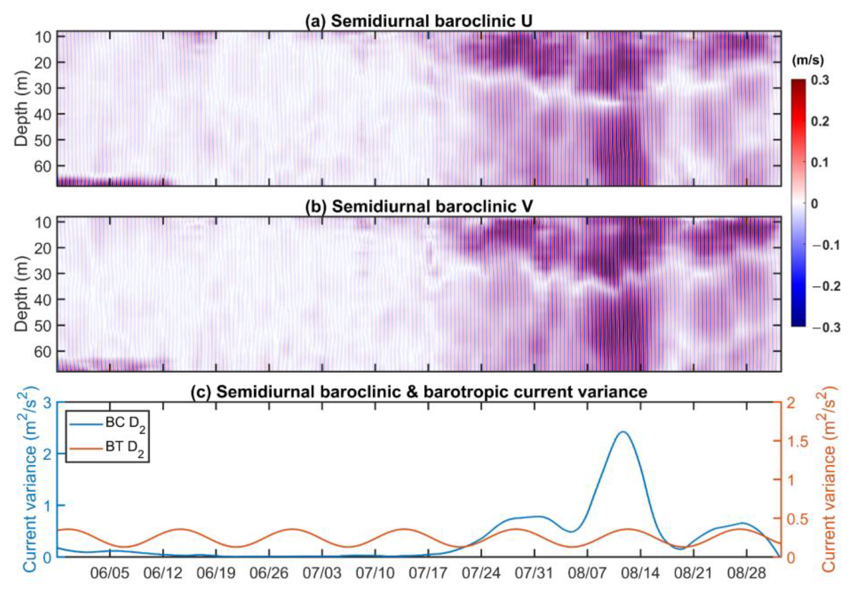
The temporal variations of semidiurnal baroclinic velocities can be seen in Figure 3. Overall, semidiurnal internal tides were quite weak before about 17 July. They appeared near the bottom for the first 14 days and then became calm after more than one month. The semidiurnal baroclinic velocities were dramatically enhanced to 30–40 cm/s from 17 July (Figure 3a–c). This velocity magnitude enhancement occurred throughout the entire water column, and in both the zonal and meridional directions. This indicates a northwest-southeast current, consistent with the major axes of the M2 and S2 tidal ellipses (Figure 2b). The tidal ellipse characteristics at the mooring disagreed with the local tidal ellipse (east-west direction) but agreed with the tidal ellipses on the corrugated continental slope and upper continental shelf (Figure 1b and Figure 2b). During the enhancement period, semidiurnal internal tides followed a spring-neap tide cycle, roughly phase-locked to the local M2-S2 spring-neap cycle. Three spring peaks were observed in the record (Figure 3c). The phase difference to the local barotropic (M2 + S2) tidal cycles was less than 2 days. These results indicated the semidiurnal internal tides may not be locally generated near the mooring, but possibly nearby on the shelf.
Unlike the dramatic change of the semidiurnal internal tides before and after 17 July, the diurnal baroclinic velocity changed less and exhibited quasi-spring-neap cycles during the full record (Figure 4). Both the timing and magnitude varied for each spring-neap cycle (Figure 4c). A majority of the internal tidal peaks lagged the barotropic tide by 5–7 days at spring tides. The timing of the second spring tide was delayed by nearly 10 days and persisted longer than the others. Compared with the strong semidiurnal internal tide, the diurnal tide was weaker, both in depth-integrated magnitude and maximum baroclinic speed.
The semidiurnal current field was divided into two vertical sections: subsurface and lower middle. A zero-crossing point fluctuated over time between 20 and 36 m (Figure 3a,b). Near-bottom intensification featured prominently in the diurnal field, with the zero-crossing point ranging between 52 and 60 m. In previous observational studies, the reversal depth was usually at the thermocline, and the velocity structure was associated with time-varying stratification [19]. As the energy source, the barotropic tides were stable during the mooring period (Figure 3c and Figure 4c).
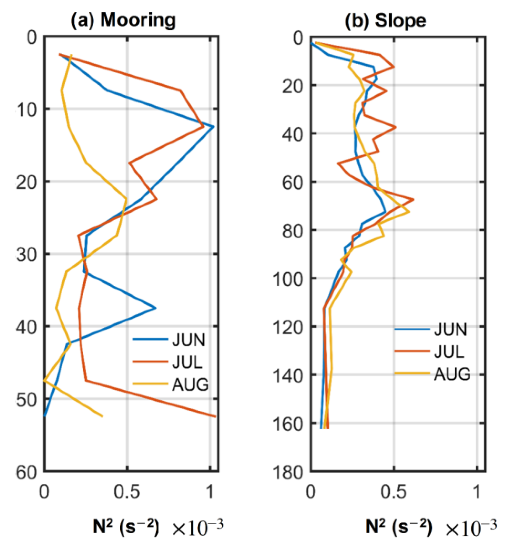
Stratification is one of the key factors that influence internal tide generation and radiation [57]. To further demonstrate the temporal and vertical internal tidal structure, the buoyancy frequencies were calculated from monthly mean T (temperature) and S (salinity) extracted from WOA18 data (Figure 5). In Figure 5b, the stratification in the slope region was quite weak in June but enhanced and formed pycnocline layers at 70 m in July and August. In contrast, the local stratification at the mooring featured different trends (Figure 5a). At depths of 10 m and 40 m, the double N2 peaks indicated the positions of two pycnocline layers. The 10 m and 40 m stratification weakened during the mooring period, while the benthic stratification increased. Different from the extremely weak abyssal stratification in the deep ocean, the benthic stratification over the shelf was comparable to that in the upper pycnocline. From Equation (1), the larger z near the seafloor resulted in a larger influence of the benthic N2 in generation. This suggests the varying stratification was potentially associated with the strength of internal tides, especially where the benthic stratification changed in the shelf region.

3.3. Internal Tide Generation Sites

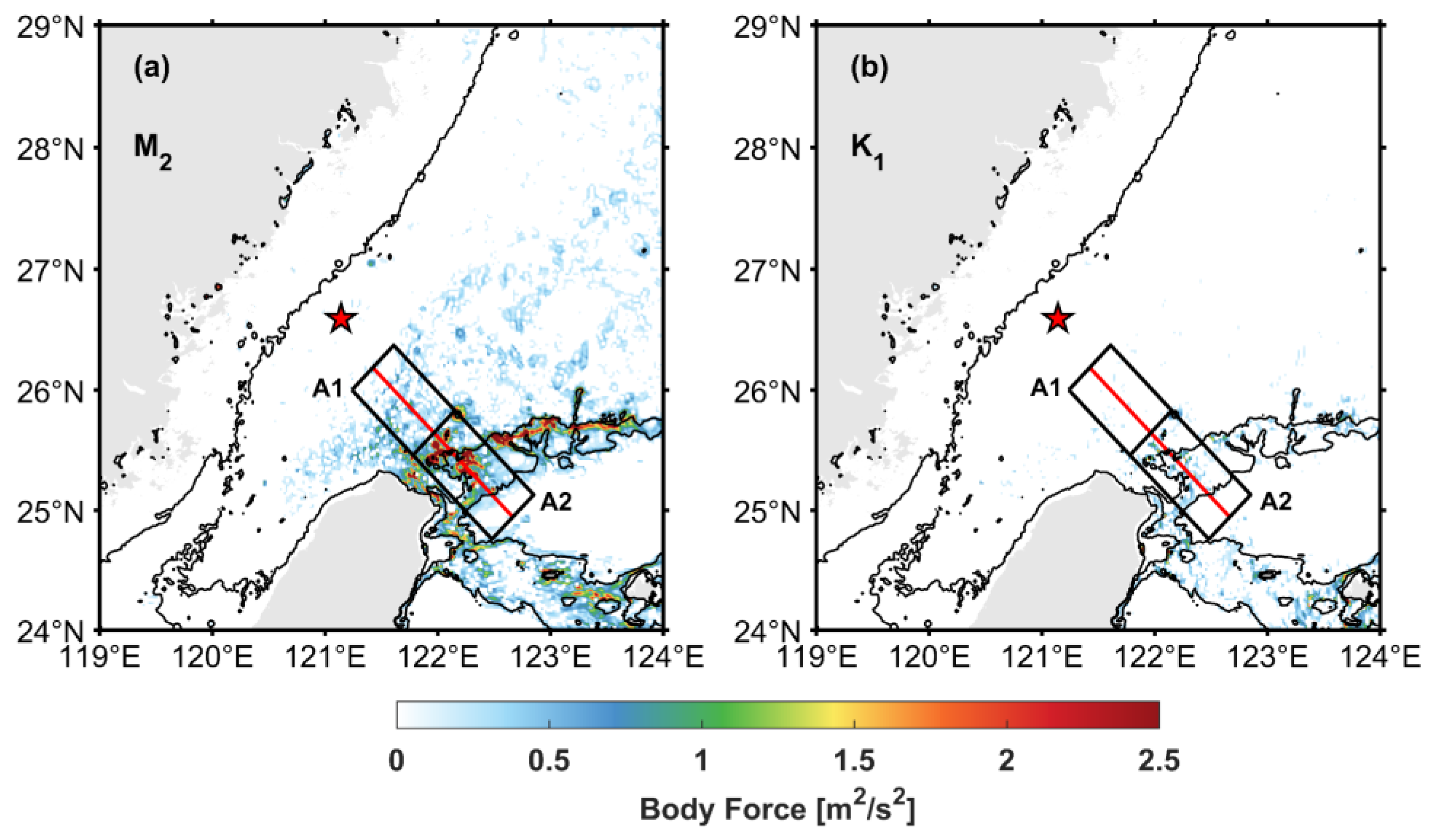
Potential internal tidal generation sites can be determined from the spatial pattern of the barotropic tidal body force. All of the high body forces were distributed near the canyon and ridges northeast of Taiwan, where the topography changes abruptly (Figure 6). Previous studies have found that the nearby continental slope and submarine canyons were major generation sites, and a portion of M2 internal tidal energy may spread to the continental shelf over a distance of one or two wavelengths [10,13]. Many discrete medium and weak M2 internal tidal energy sources were also found in the shelf region (Figure 6a). Other numerical results suggested the shelf as an M2 internal tidal energy source [41]. Considering body forces near the observation point are very small, they are unlikely to generate noticeable internal tides; therefore, the internal tide at the mooring location most likely radiated from northeast of Taiwan (Figure 6 black box). In our area of concern, the semidiurnal tidal body force was obviously larger than that of diurnal tides, and the integrated body force of semidiurnal tides was more than four times that of diurnal tides (Figure 6 and Table 2). The proportion of the shelf region was around 20% of the total for both M2 and K1 internal tides. The K1 slope generation is nearly equivalent to M2 generation over the shelf. Meanwhile, diurnal baroclinic velocity was also comparable to its semidiurnal counterpart in terms of the order of magnitude. The association between the shelf-slope generation and distinct internal tides features will be further explored in the following sections.
The observations indicated considerably more semidiurnal internal tide energy at the moorings later in the record after 17 July. To investigate this change, we applied monthly means of WOA18 stratifications to the body force calculations. Background stratification can affect internal tidal generation, leading to temporal variability in the baroclinic tidal energy, which will also be reflected in the body force (Table 2). Stratification both at the mooring (Figure 5) and over the slope northeaster of Taiwan changed significantly. Generally, the stratification was stronger during both July and August compared to June, so the body forces in July and August also increased, with the largest increase exceeding 20% in August. However, the changing stratification trends for the shelf and slope were not exactly similar. We further investigated the body force in the shelf (A1 in Figure 6) and slope regions (A2 in Figure 6). The M2 body force in A1 (shelf region) had greater variability than that in A2 (slope region). The M2 internal tide generation in the shelf region increased ~25% in July over June and ~51% in August over June. The increasing rates in the slope region were all below 20%. Therefore, the varying stratification contributed significantly to the variability of semidiurnal internal tide generation, especially the shelf generation. The occurrence of strong semidiurnal internal tides possibly resulted from the preferable stratification conditions for generation over the shelf region.

3.4. Modal Contribution Modulated by Background Current

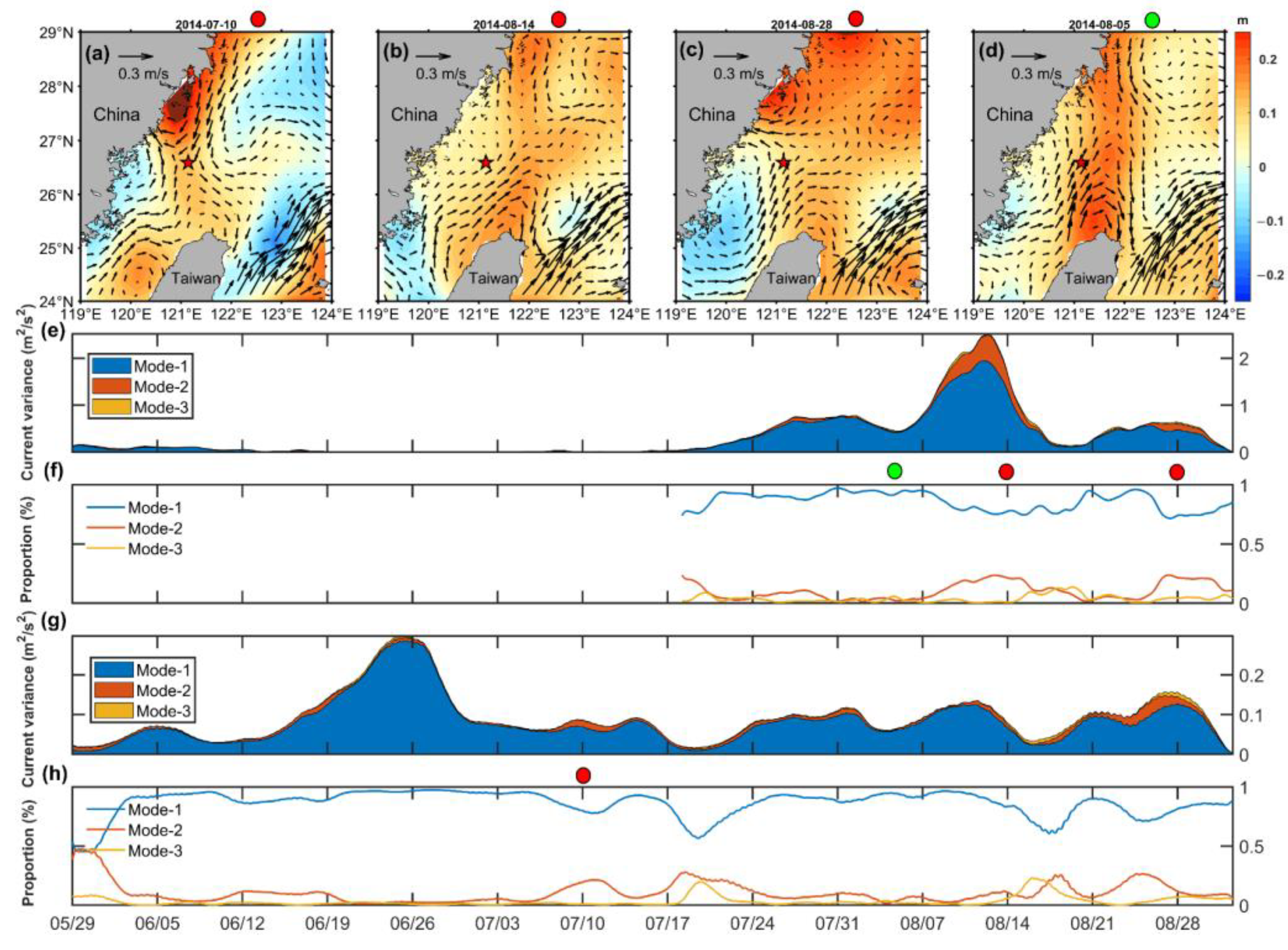
Through moving overlapped EOF analysis, the depth-integrated velocity variance for the lowest three modes of the semidiurnal and diurnal internal tides can be seen in the stacked histograms (Figure 7e,g). Modes higher than three accounted for less than 3% energy in total out of 8 modes (not shown). Semidiurnal internal tides at the early stages were not analyzed due to their low energies. For both the semidiurnal and diurnal internal tides, the first mode dominated and provided over 85% of the energy most of the time. The second and third modes made minor contributions. These results are consistent with the former analysis of tidal current ellipses and baroclinic velocity fields. However, there was still a strong temporal dependence in the energy proportions (Figure 7f,h). Vertical modes of internal tides can be modified by background current shear [30]. Our results show that low-frequency shear was not strong in the early stage, and the proportion of first mode diurnal internal tides was relatively stable, accounting for ~90%. After 17 July, the intensified shear was accompanied by intermittent increases of mode-2 proportions for both semidiurnal and diurnal internal tidal constituents. Especially around 14 and 28 August, low-frequency shear was significantly enhanced in the shallow layer, and the proportion of the mode-2 and 3 energy exceeded ~30% for semidiurnal and diurnal internal tides. It is likely that the energy of the mode-2 and 3 internal tides was transferred through the mode-1 internal tide because the total energy remained relatively constant and still followed the quasi spring-neap variability. Furthermore, the high mode increase occurred during some spring tides and during times of weaker internal tides.
Based on observations and numerical simulations, previous studies found that eddy-wave interactions could result in energy transfers from the mode-1 internal tides to higher modes [27,29]. Eddies frequently occur in this region according to AVISO data, so eddy-wave interactions are possible. During the three eddy periods (Figure 7a–c), the mooring was located on the edge of a strong lateral shear area, and the mode-2 and mode-3 proportions increased.

3.5. Diurnal Tidal Critical Latitude Effect

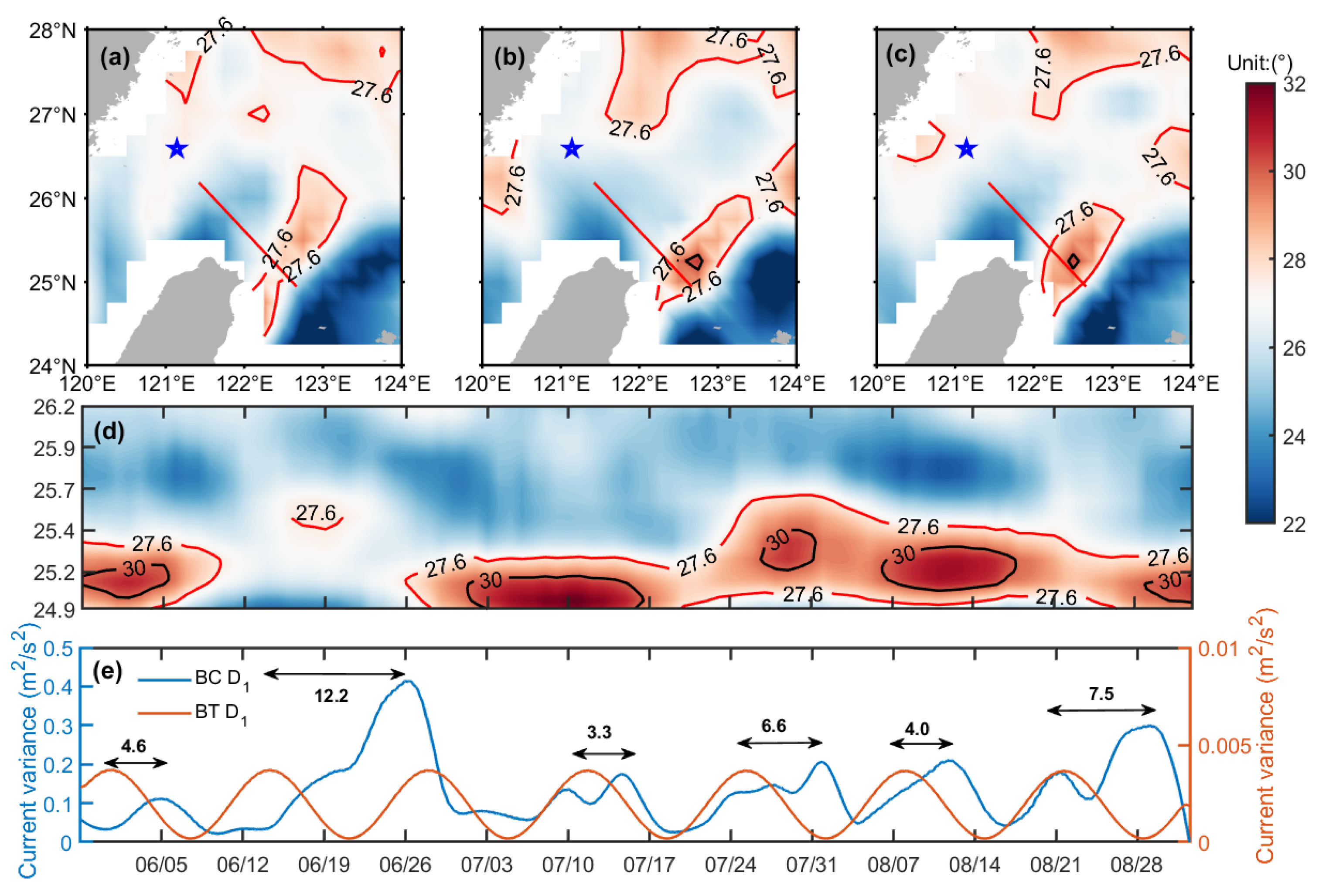
Where and when diurnal critical latitude effects occur may shift through the addition of positive or negative relative vorticity associated with varying circulation conditions. Relative vorticity exists in eddies, at the edges and meanders of western boundary currents, and in the flow along the continental slope. Observation and simulation results indicated a shift of the diurnal critical latitude(s), potentially of up to several degrees, when it encounters a mesoscale current [32]. Mesoscale motions are energetic enough to evoke strong vorticity for constructing a complicated field of effective latitude (Figure 8a–c). The Kuroshio front and its intrusion bifurcation beam, the Taiwan Warm Current (TWC), together shifted the effective latitude in the area northeast of Taiwan Island [58]. The circulation pattern in summer created a prominent positive shift of effective latitude. The vorticity was sufficient to shift the effective latitude of the shelf slope area from geographical 25°N–26°N to beyond 27.6° and even 30°. This made an area geographically 2–5° equatorward of the diurnal critical latitude, also under the influence of the diurnal critical latitude(s). This area covered a large part of the diurnal internal tidal generation sites (Figure 6). In this context, O1 and K1 critical latitude effects influenced the generation and propagation of diurnal internal tides by various degrees.
There was a good correspondence between the temporal variations of the diurnal internal tides and the effective latitude near the generation sites. To further evaluate the role of the diurnal critical latitude in modulating internal tidal propagation, the daily shifts of the effective latitude on the propagation path (Figure 8d) were connected with the time series of diurnal internal tides (Figure 8e). Critical latitude effects can cause remarkable changes in the intensity of remote diurnal internal tides. When the cyclonic eddy was weak during two specific periods (12–16 June and 21–28 August), the effective latitude deviated less from the local latitude. Unlimited by the critical latitude restrictions, all along-slope-generated internal tides freely propagated, resulting in a larger observed magnitude and a wider spring-tide peak (Figure 8e).
At other times, the effective latitude value frequently exceeded 27.6° and 30° (red areas in Figure 8d). The red areas correspond to the lower part of the red line in Figure 6 and Figure 8a–c, which were both major generation sites and beginning points of propagation for diurnal internal tides. Consequently, the critical latitude effects actually work in this area during these times. Considering that the effective area of critical latitudes and the generation sites in the shelf-slope region heavily overlapped, it was unlikely to cover all source regions (Figure 6 and Figure 8). The effective area of O1 critical latitude was larger than K1 (Figure 8a–d). Therefore, the portion of K1 generated beyond the effective area of K1 critical latitude could freely propagate, while most of the O1 internal tides were expected to be trapped. Observed diurnal internal tides were not so strong at that time. Spring-neap cycles were also modified by the effects on these two tidal constituents, O1 and K1, as the superposition of O1 and K1 dominated the spring-neap cycle.

3.6. High-Frequency Internal Wave and Energy Cascades

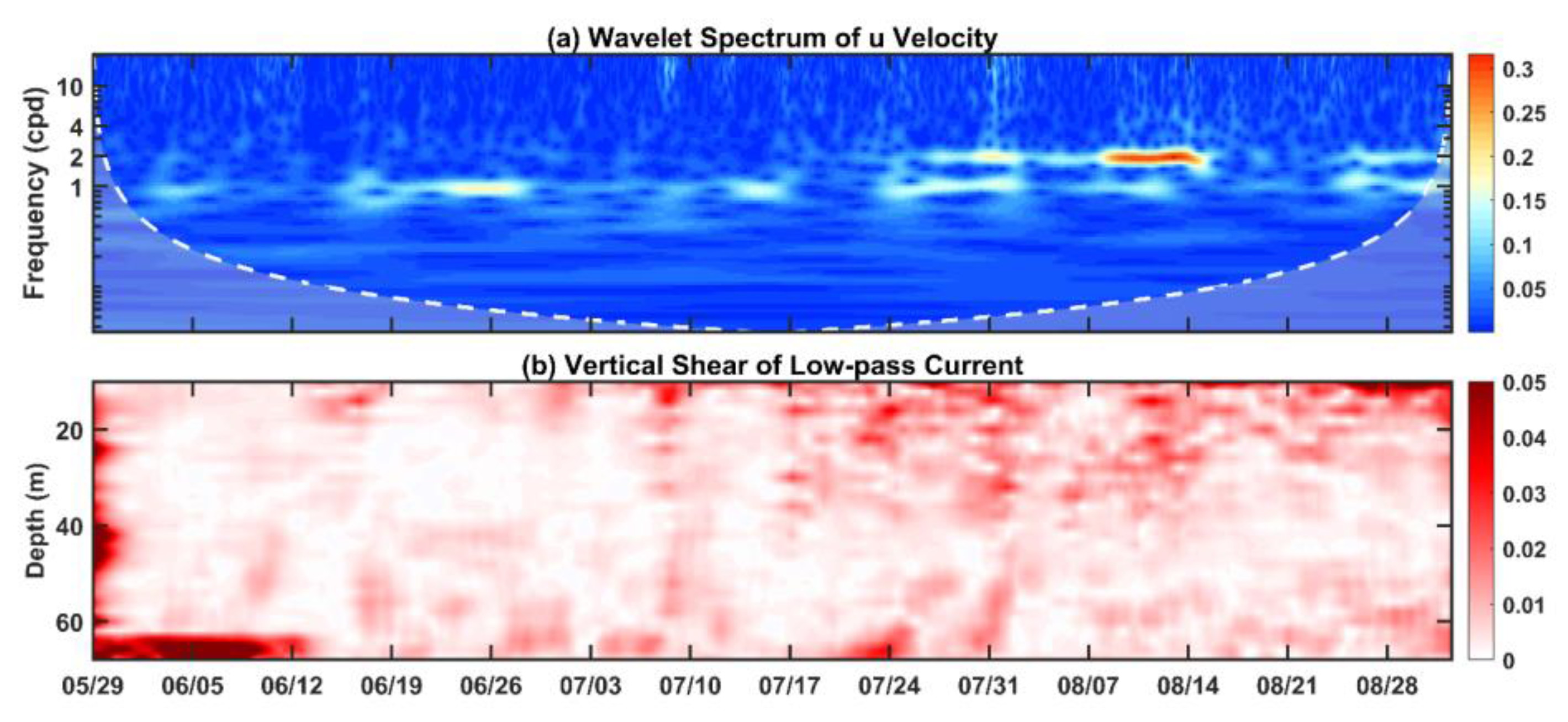
Wavelet analysis was applied to the time series of the baroclinic velocity anomalies at 60 m depth, and the baroclinic energy distribution in frequency and time is presented in Figure 9a. From the magnitudes in the scalogram, baroclinic energy was concentrated in the diurnal (1 cpd) and semidiurnal (2 cpd) bands. The wavelet results also showed vigorous energy and variability at these tidal bands, consistent with the baroclinic velocity record and the mode histograms. The periods of energetic semidiurnal and diurnal internal tides revealed in Figure 9a were consistent with former results.
Apart from internal tides, intermittent high-frequency internal waves occurred and responded significantly to the low-frequency vertical velocity shear. High-frequency internal wave (>4 cpd) pulses occurred on 10, 17, 24, and 31 July and were enhanced from 7 to 21 August (Figure 9a). The occurrences of these high-frequency signals coincided with the strong vertical shear periods (Figure 9). These periods were observed to be deep-reaching and could potentially catalyze nonlinear wave–wave interactions at 60 m. Moreover, when both the semidiurnal and diurnal internal tides were energetic during these periods, the high-frequency waves were also more powerful and continuous in the frequency domain from 2 cpd to above 10 cpd. This indicates that when low-frequency shear flows encountered the strong internal tides, they drew internal tidal energy to cascade from low to higher frequencies.

4. Discussion

Both semidiurnal and diurnal internal tides have been observed over the ECS continental shelf. Although semidiurnal internal tides dominated, the diurnal signal was also significant, particularly in benthic layers. The phases of the diurnal baroclinic velocity anomalies were obviously associated with the tidal cycles, apparently indicating generation through a barotropic flow-topography interaction. The results were quite different from previous slope observations. They suggested either the diurnal internal tides were an order of magnitude weaker with a secondary influence [56] or associated diurnal-band internal waves with a parametric subharmonic instability (PSI) mechanism that transferred energy from semidiurnal internal tides to half their frequency, also diurnal band, but mainly regarded as near-inertial wave [15].
Similar mode-1 structures of two semidiurnal internal tidal constituents, M2 and S2, reinforced the dominance of mode-1 and the magnitude of semidiurnal internal tides. Multimodal O1 tides were found in our results and other ECS slope studies [56]. In the SCS, another marginal sea of the western Pacific, O1, usually exhibited a mode-1 structure [21]. Compared with SCS, O1 is closer to the local Coriolis frequency in the ECS, which is regarded as the lower limit for the O1 internal tide. However, the background flow induced sufficient positive relative vorticity to the Coriolis frequency (Figure 8d) for O1 to be sub-inertial or inertial. Internal tides will not propagate freely in proximity to their critical latitude, and their vertical wave number tends to be infinite, resulting in a multimodal O1 structure [32].
Although the generation sites were indicated by the body force distribution, specific source regions require further investigation. It is evident that spot bands of semidiurnal internal tide generation existed over both the shelf and slope, while the diurnal internal tide was only generated in a narrow slope area (Figure 6). The time lags between semidiurnal internal tides and semidiurnal barotropic velocities (~1–2 days) were smaller than those between the diurnal internal tides and the diurnal barotropic velocities (~3–12 days) (Figure 3c and Figure 8e). To estimate the energy source(s) and evaluate the propagation of internal tides, the eigenspeed (Cn) of normal modes (n) can be determined by solving the Taylor–Goldstein equation with zero background flow [59]:
d 2 Φ ( z ) dz 2 + N 2 ( z ) c n 2 = 0 ,
where Φ(z) is the vertical displacement in baroclinic modes, which is subjected to buoyancy frequency profile N2(z). The Eigenvalue equation can be numerically solved [60]. We focus on the mode-1 internal tides. Due to the Earth’s rotation, the phase speed Cp can be calculated from eigenspeed C as follows [33]:
C p = ω ω 2 f 2 C ,
where ω is the tidal frequency, f is the Coriolis frequency. Equation (3) When we replace the f in Equation (3) with feff, we can get phase velocity with the background currents. The effect of background current was taken into consideration by modified effective Coriolis frequency:
C p e f f = ω ω 2 f e f f 2 C ,
The spring-neap cycle and energy of the semidiurnal internal tide propagate at the group velocity [61]. The group velocity Cg and phase velocity Cp can be calculated as follows:
C p = ω k  
C g = d ω d k = ω 1 ω 2 k 1 k 2  
On the basis of the phase velocity, the wave number k of two participating tidal constituents can be obtained. The group velocity can be calculated as the frequency and wave number differences between the tidal constituents (M2–S2 in semidiurnal and K1–O1 in diurnal). Similarly, the effect of background current can be taken into account as:
  C p e f f = ω k e f f  
C g e f f = d ω d k e f f = ω 1 ω 2 k e f f 1 k e f f 2  
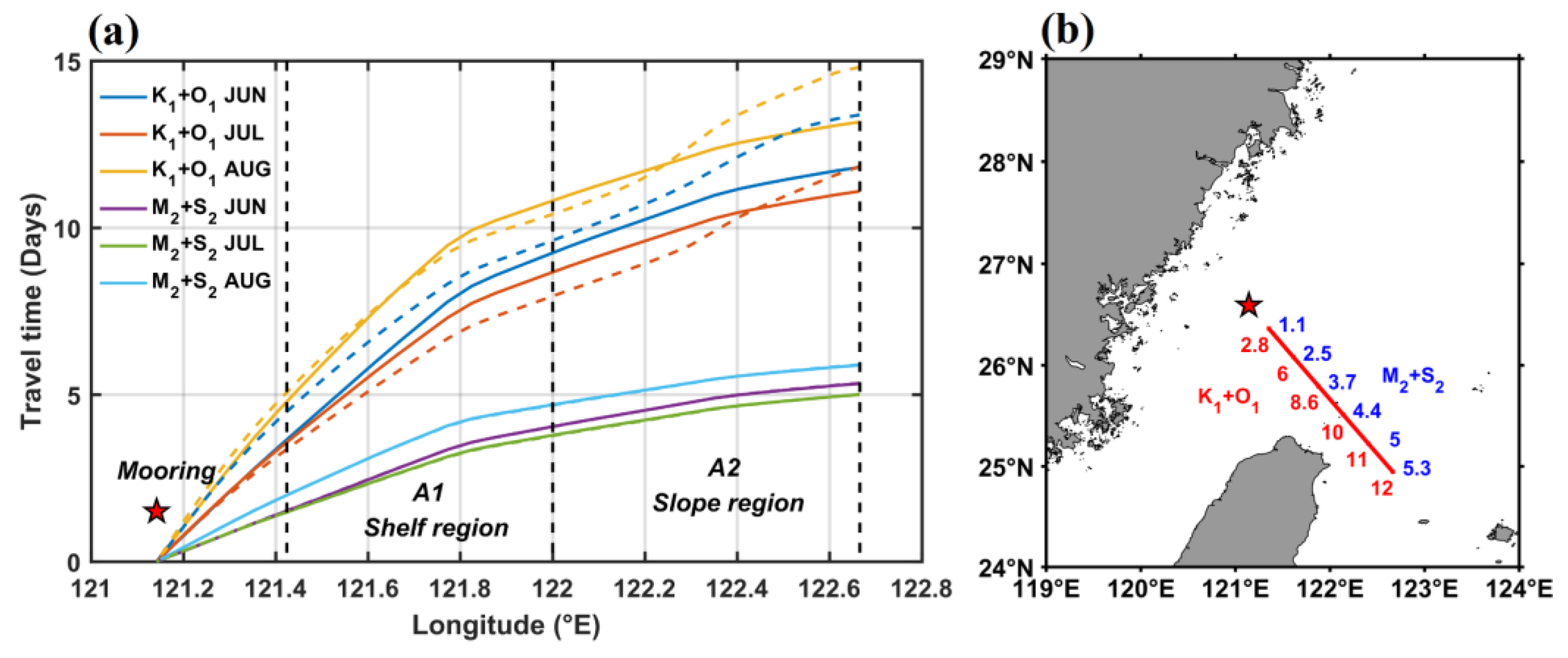
The internal tidal travel times are calculated by cumulating the time at group velocity along the propagation path. Travel time for K1 + O1 from the source area is close to twice that of M2 + S2, that is, for the same distance, it takes longer for the diurnal spring-neap phase to travel compared to the semidiurnal spring-neap (Figure 10a). From near shelf to far slope, the internal tides propagated faster and faster. One reason is the latitude variation. In general, internal tides at higher latitudes propagate slower. However, such a sharp change is not indicated in the narrow latitude range in the former study [61]. Stratification may reinforce this change. The strongest stratification in August slows down the propagation of internal tides.
The role of stratification and background currents in modifying the travel time is also shown in Figure 10. Lines in different colors represented the effect of stratification for different months. Dashed lines represent the monthly mean horizontal flow. Compared with semidiurnal internal tides, diurnal internal tides are more susceptible to the influence of stratification and currents. The influence of these two factors was comparable to diurnal internal tides (~1 day). The stratification changes slightly influenced the semidiurnal travel times (several hours). While the dashed lines nearly overlapped with the solid lines, this indicated the relative vorticity of mean flow made a negligible change on semidiurnal propagation. Previous study found the different Kuroshio paths in Luzon Strait could alter the radiation pattern and magnitude of semidiurnal internal tides [62]. In present study, background current changed not so much in these several months, and less regulated the semidiurnal internal tides.
The travel times along the propagation path are presented in Figure 10b. The observed time lags to barotropic tidal cycles combined with travel times indicated the internal tides’ energy source in the generation map. It can be expected that semidiurnal internal tides originate from the nearby inside shelf and diurnal internal tides far from the shelf-slope and even the slope region when the critical latitude effects are weak.
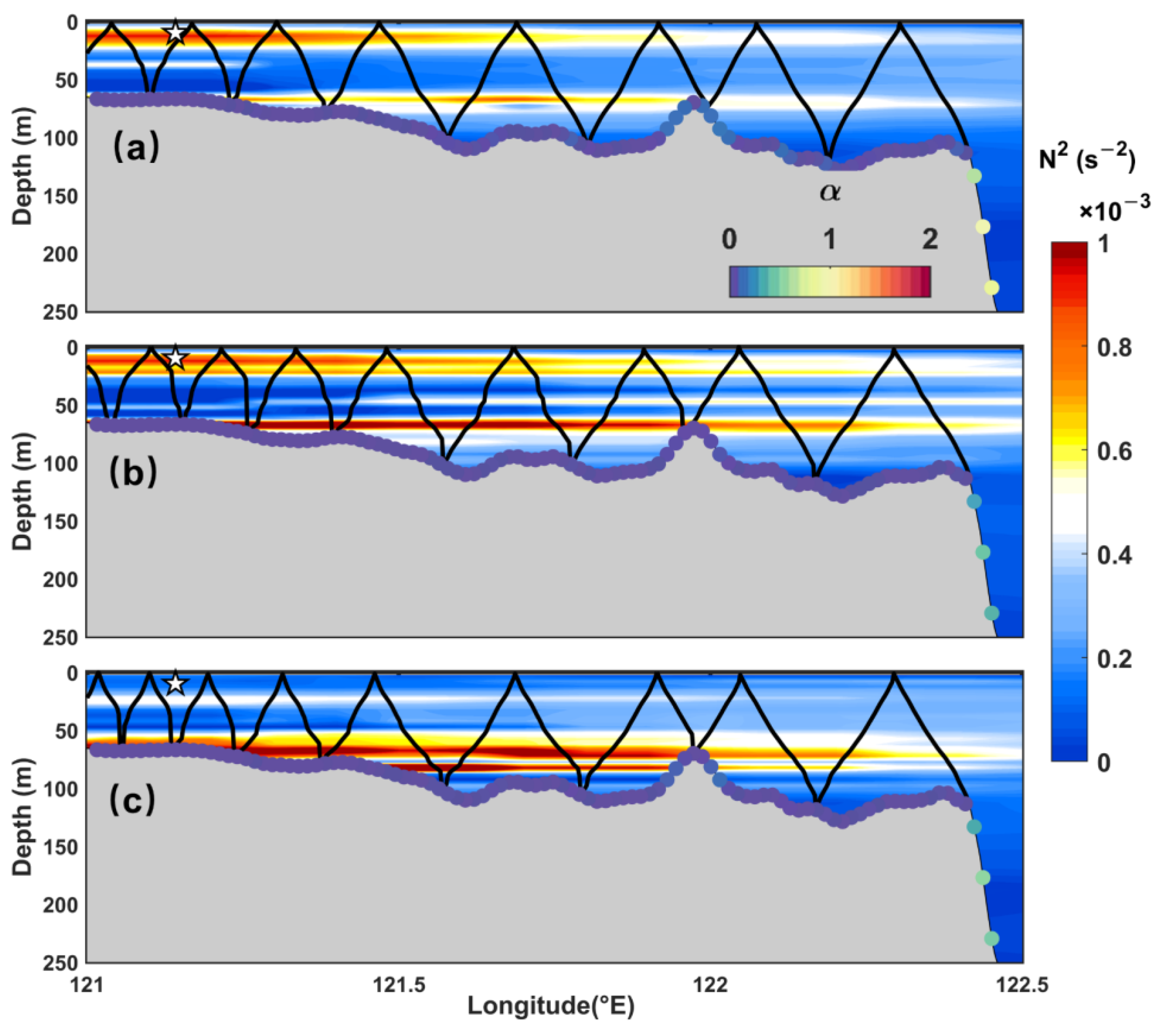
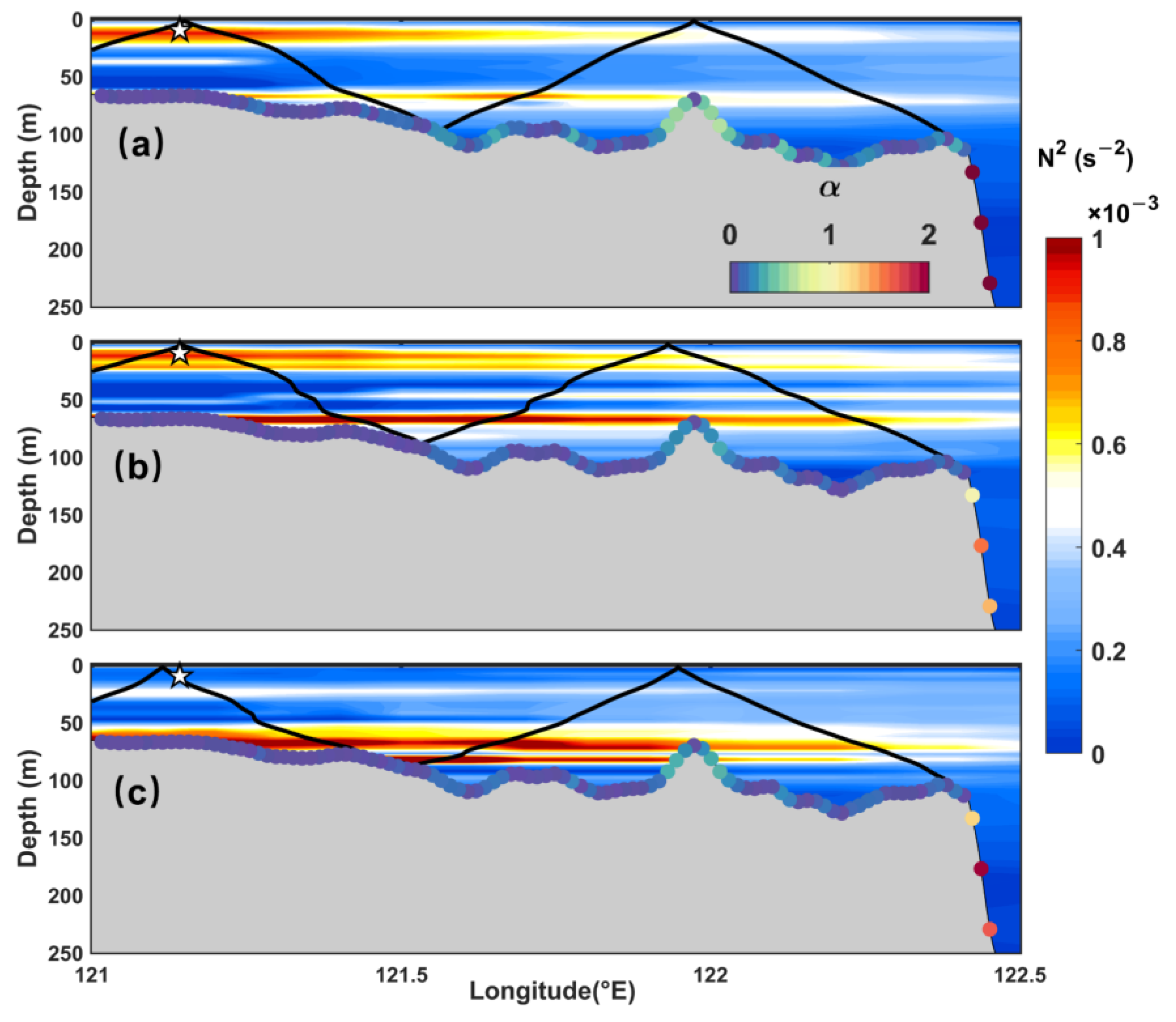
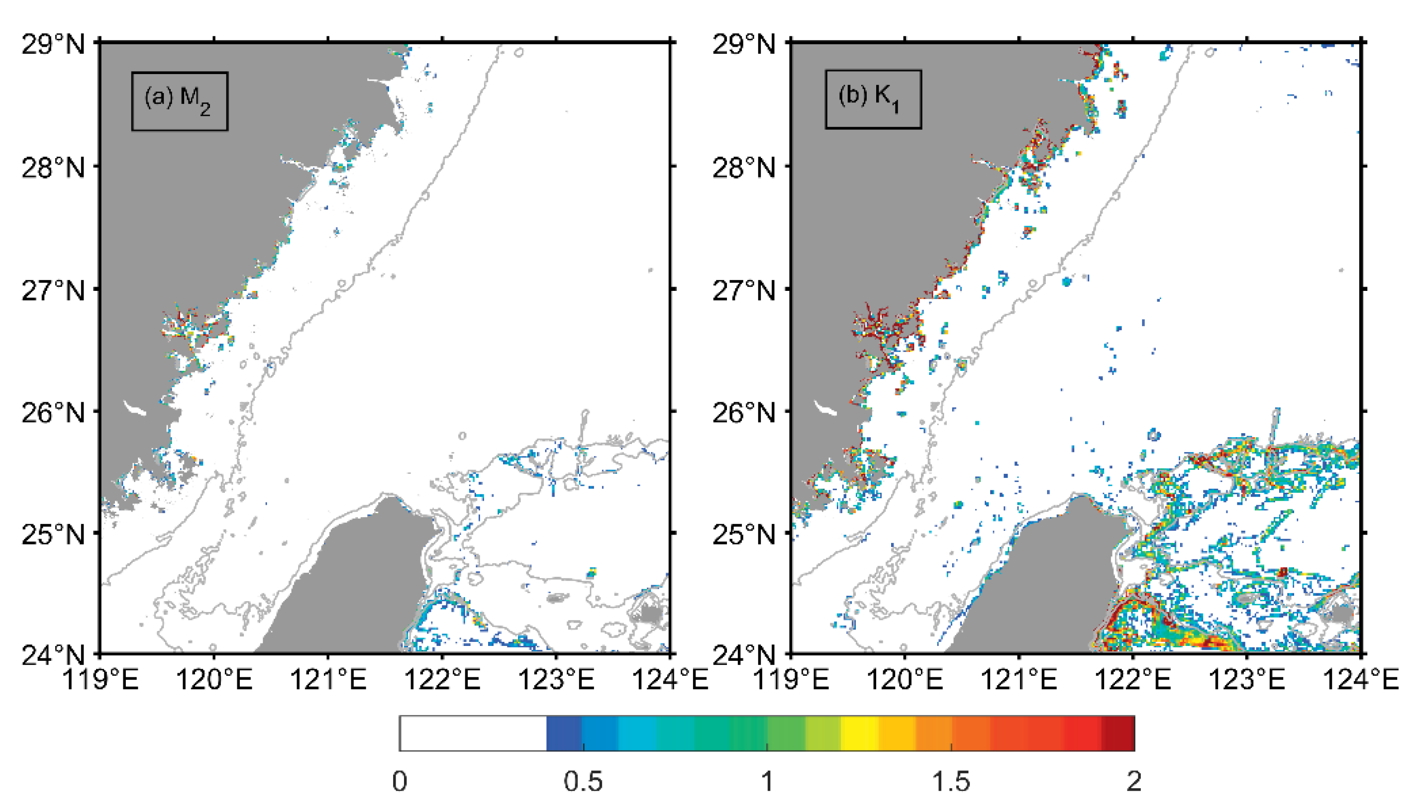
Moreover, semidiurnal and diurnal internal tidal wavelengths were estimated to be 10–20 km (Figure 11) and 70–80 km (Figure 12), respectively. Bathymetry criticality along the propagation path is subcritical for both M2 (Figure 11 and Figure 13a) and K1 (Figure 12 and Figure 13b) internal tides. The topographic slope is not a limit for M2 and K1 generated on the slope shoaling on the shelf; however, due to the large bottom friction on the shelf, it is still highly unlikely that the semidiurnal internal tides from the slope area reach the mooring site after ~10 bottom-surface reflections, without any signs of damping [2,63]. Therefore, the observed diurnal internal tides should be remotely generated on the slope, while the semidiurnal internal tides were generated on the shelf near the observation site.
The background vorticity has a greater impact on the propagation speed of the K1 internal tide. The tidal frequency of the K1 tide is closer to f, and by Equation (3), the diurnal phase velocity and group velocity are more sensitive to the change from f to feff. In addition, the propagation directions of diurnal internal tides were more horizontal than those of semidiurnal internal tides under the same stratification, so that diurnal internal tides were more sensitive to the horizontal circulation. As a result, the spring tide peak was flatter, the duration longer, and the time lags of each tidal cycle were more changed.
Internal tidal energy with respect to mode contents and frequency shift was modulated by the background currents. The decrease of mode-1 internal tidal proportion corresponded to the enhancement of horizontal shear associated with background circulation, indicating the energy scattering from low modes to higher modes. The existence of background low-frequency shear also coincided with strengthened high-frequency energy. Furthermore, the coexistence of semidiurnal and diurnal frequencies more easily facilitated the energy cascade to high-frequency bands (Figure 9). The occurrence of semidiurnal internal tides increased the energy source for the energy cascade and became a jumping board for more wave–wave nonlinear interactions in frequency space. The resultant high-mode and high-frequency internal waves promoted the transfer of tidal energy to turbulence scales, providing more energy for mixing.
In addition, the relative vorticity of the ECS background currents was another contributor to the variation of internal tides. We found the mesoscale subtidal circulation near the critical latitude significantly regulated the diurnal internal tides. Previous research pointed out that critical latitude effects may modify the internal wave frequency continuum through nonlinear interactions [31,32]. The effective critical latitude described here is not only a geographic concept, but a geodynamic factor, quantitatively expressing the influence of background flow on shifting the effects of critical latitude. By comparing the effective latitude with critical latitude, we could intuitively estimate critical latitude effects on the internal tide energetics in a realistic ocean.

5. Conclusions

In this study, the temporal variations of internal tides on the ECS continental shelf and their controlling factors were investigated based on mooring observations. We highlighted the different temporal variability of semidiurnal internal tides and diurnal internal tides. Semidiurnal internal tides showed significant enhancement over the last three spring-neap cycles between early summer and late summer. The diurnal internal tidal amplitudes were relatively stable during the mooring period. M2 and K1 internal tides were the largest constituents, and both were mode-1dominated. The M2 internal tidal amplitude intensified near the surface while that of K1 intensified above the bottom.
The generation sources of semidiurnal (M2) and diurnal (K1) internal tides were revealed by distribution maps of body force. The shelf-slope region northeast of Taiwan was the major source region, as preceding research concluded. A majority of M2 and K1 internal tides were generated over the slope. M2 internal tides were also locally generated inside the inner ECS shelf, which has been rarely mentioned before. Nevertheless, the local source sites are still away from the observation site. The distribution of generation sources, coupled with the time lag between baroclinic and barotropic tides, indicated that the observed internal tides propagated from a remote region. The stratification was stronger in July and August than in June, so the calculated body force changed similarly. In addition, changes in stratifications at the shelf explained a significant fraction of the variability in the semidiurnal internal tides.
The relative vorticity associated with background currents regulated the critical latitude effects by changing the size of the effective area and the time range in which they took effect. As a result, the propagation of the related diurnal internal tides varied with time and space. The increasing diurnal internal tidal magnitudes and the accordance of observed time lag and theoretical travel time on the propagation path consistently confirmed the process at the remote slope identified in observations. In addition, background currents played a vital role in tidal energy transfer, not only between the different vertical modes, but also between internal tides with high-frequency internal waves. The lateral shear resulted in high mode, and the vertical shear facilitated high-frequency internal waves and an energy cascade.
The upcoming Surface Water Ocean Topography (SWOT) mission will measure the sea surface with an unprecedented high spatial resolution and provide us with a wealth of data. However, we need to combine multiple methods with the SWOT mission in order to accurately investigate the energy cascade processes between tidal signals, mesoscale, and sub-mesoscale variability. Therefore, more specific in situ observations and numerical simulations are critical for further investigation.

Author Contributions

Conceptualization, W.W., Y.W. and Z.X.; methodology, W.W., Y.W. and R.R.; validation, Y.W., Z.H. and R.R.; formal analysis, W.W.; resources, B.Y.; writing—original draft preparation, W.W.; writing—review and editing, R.R., Y.W., Z.H. and Z.X.; visualization, W.W., C.Z.; supervision, B.Y. and Z.X.; project administration, B.Y. and Z.X.; funding acquisition, B.Y. and Z.X. All authors have read and agreed to the published version of the manuscript.

Funding

This study was jointly supported by the Strategic Pioneering Research Program of CAS, the National Natural Science Foundation of China (NSFC), the NSFC-Shandong Joint Fund, the National Key Research and Development Program of China (XDA22050202, 92058202, XDB42000000, 42076022, U1806227, 2017YFA0604102), the CAS Key Research Program of Frontier Sciences, the Key Deployment Project of Center for Ocean Mega-Research of Science, and the project jointly funded by the CAS and CSIRO (QYZDB-SSW-DQC024, COMS2020Q07, 133244KYSB20190031).

Data Availability Statement

The datasets for this study are publicly available. The altimetry sea level anomalies and geostrophic velocities are provided by Archiving, Validation, and Interpolation of Satellite Oceanographic (AVISO) data and distributed by the Copernicus Marine Environment Monitoring Service (CMEMS) via https://marine.copernicus.eu/ (accessed on 12 March 2022). The bathymetry data are available from https://topex.ucsd.edu/cgi-bin/get_data.cgi (accessed on 12 March 2022). The TPXO tidal atlas can be downloaded from https://www.tpxo.net/tpxo-products-and-registration (accessed on 12 March 2022). The World Ocean Atlas (WOA18) is available from NOAA National Centers for Environmental Information via https://accession.nodc.noaa.gov/NCEI-WOA18 (accessed on 12 March 2022). The mooring data presented in this study are available from the corresponding author upon reasonable request.

Acknowledgments

The acquisition of mooring data was supported by Western Pacific Ocean System: Structure, Dynamics, and Consequences, WPOS. We are grateful to the entire crew of R/V Kexue I for their expertise and hard work. We are grateful to Jifeng Qi and Fei Yu for data curation. Discussions with my fellows Xiaoyu Zhao and Jia You were very helpful.

Conflicts of Interest

The authors declare no conflict of interest. The funders had no role in the design of the study; in the collection, analyses, or interpretation of data; in the writing of the manuscript, or in the decision to publish the results.

References

  1. Baines, P.G. On Internal Tide Generation Models. Deep Sea Res. Part A Oceanogr. Res. Pap. 1982, 29, 307–338. [Google Scholar] [CrossRef]
  2. Kelly, S.M.; Jones, N.L.; Nash, J.D.; Waterhouse, A.F. The Geography of Semidiurnal Mode-1 Internal-Tide Energy Loss. Geophys. Res. Lett. 2013, 40, 4689–4693. [Google Scholar] [CrossRef]
  3. Cacchione, D.A.; Pratson, L.F.; Ogston, A.S. The Shaping of Continental Slopes by Internal Tides. Science 2002, 296, 724–727. [Google Scholar] [CrossRef] [Green Version]
  4. Müller, M. On the Space- and Time-Dependence of Barotropic-to-Baroclinic Tidal Energy Conversion. Ocean Model. 2013, 72, 242–252. [Google Scholar] [CrossRef]
  5. Simmons, H.L.; Hallberg, R.W.; Arbic, B.K. Internal Wave Generation in a Global Baroclinic Tide Model. Deep. Res. Part II Top. Stud. Oceanogr. 2004, 51, 3043–3068. [Google Scholar] [CrossRef]
  6. Zhao, Z.; Alford, M.H.; Girton, J.B.; Rainville, L.; Simmons, H.L. Global Observations of Open-Ocean Mode-1 M2 Internal Tides. J. Phys. Oceanogr. 2016, 46, 1657–1684. [Google Scholar] [CrossRef]
  7. Carrere, L.; Arbic, B.K.; Dushaw, B.; Egbert, G.; Erofeeva, S.; Lyard, F.; Ray, R.D.; Ubelmann, C.; Zaron, E.; Zhao, Z.; et al. Accuracy Assessment of Global Internal-Tide Models Using Satellite Altimetry. Ocean Sci. 2021, 17, 147–180. [Google Scholar] [CrossRef]
  8. Zaron, E.D. Baroclinic Tidal Sea Level from Exact-Repeat Mission Altimetry. J. Phys. Oceanogr. 2019, 49, 193–210. [Google Scholar] [CrossRef]
  9. Zhao, Z. Seasonal Mode-1 M2 Internal Tides from Satellite Altimetry. J. Phys. Oceanogr. 2021, 51, 3015–3035. [Google Scholar] [CrossRef]
  10. Niwa, Y.; Hibiya, T. Three-Dimensional Numerical Simulation of M2 Internal Tides in the East China Sea. J. Geophys. Res. Ocean. 2004, 109, 1–14. [Google Scholar] [CrossRef]
  11. Wang, Y.; Xu, Z.; Yin, B.; Hou, Y.; Chang, H. Long-Range Radiation and Interference Pattern of Multisource M2 Internal Tides in the Philippine Sea. J. Geophys. Res. Ocean. 2018, 123, 5091–5112. [Google Scholar] [CrossRef] [Green Version]
  12. Tian, J.; Zhou, L.; Zhang, X.; Liang, X.; Zheng, Q.; Zhao, W. Estimates of M2 Internal Tide Energy Fluxes along the Margin of Northwestern Pacific Using TOPEX/POSEIDON Altimeter Data. Geophys. Res. Lett. 2003, 30, 4–7. [Google Scholar] [CrossRef]
  13. Chang, H.; Xu, Z.; Yin, B.; Hou, Y.; Liu, Y.; Li, D.; Wang, Y.; Cao, S.; Liu, A.K. Generation and Propagation of M2 Internal Tides Modulated by the Kuroshio Northeast of Taiwan. J. Geophys. Res. Ocean. 2019, 124, 2728–2749. [Google Scholar] [CrossRef]
  14. Lien, R.C.; Sanford, T.B.; Jan, S.; Chang, M.H.; Ma, B.B. Internal Tides on the East China Sea Continental Slope. J. Mar. Res. 2013, 71, 151–186. [Google Scholar] [CrossRef]
  15. Yang, W.; Wei, H.; Zhao, L. Parametric Subharmonic Instability of the Semidiurnal Internal Tides at the East China Sea Shelf Slope. J. Phys. Oceanogr. 2020, 50, 907–920. [Google Scholar] [CrossRef]
  16. Hsu, M.K.; Liu, A.K.; Liu, C. A Study of Internal Waves in the China Seas and Yellow Sea Using SAR. Cont. Shelf Res. 2000, 20, 389–410. [Google Scholar] [CrossRef]
  17. Zhao, Z.; Liu, B.; Li, X. Internal Solitary Waves in the China Seas Observed Using Satellite Remote-Sensing Techniques: A Review and Perspectives. Int. J. Remote Sens. 2014, 35, 3926–3946. [Google Scholar] [CrossRef]
  18. Li, X.; Zhao, Z.; Han, Z.; Xu, L. Internal Solitary Waves in the East China Sea. Acta Oceanol. Sin. 2008, 27, 51–59. [Google Scholar]
  19. Zhao, Z.; Alford, M.H.; Lien, R.C.; Gregg, M.C.; Carter, G.S. Internal Tides and Mixing in a Submarine Canyon with Time-Varying Stratification. J. Phys. Oceanogr. 2012, 42, 2121–2142. [Google Scholar] [CrossRef]
  20. Xu, Z.; Yin, B.; Hou, Y.; Liu, A.K. Seasonal Variability and North-South Asymmetry of Internal Tides in the Deep Basin West of the Luzon Strait. J. Mar. Syst. 2014, 134, 101–112. [Google Scholar] [CrossRef]
  21. Cao, A.; Guo, Z.; Lv, X.; Song, J.; Zhang, J. Coherent and Incoherent Features, Seasonal Behaviors and Spatial Variations of Internal Tides in the Northern South China Sea. J. Mar. Syst. 2017, 172, 75–83. [Google Scholar] [CrossRef]
  22. Liu, J.; He, Y.; Wang, D.; Liu, T.; Cai, S. Observed Enhanced Internal Tides in Winter near the Luzon Strait. J. Geophys. Res. Ocean. 2015, 120, 6637–6652. [Google Scholar] [CrossRef]
  23. Zhai, R.W.; Chen, G.Y.; Liang, C.R.; Shang, X.D.; Xie, J.S. The Influence of ENSO on the Structure of Internal Tides in the Xisha Area. J. Geophys. Res. Ocean. 2020, 125, e2019JC015405. [Google Scholar] [CrossRef]
  24. Devlin, A.T.; Jay, D.A.; Talke, S.A.; Zaron, E. Can Tidal Perturbations Associated with Sea Level Variations in the Western Pacific Ocean Be Used to Understand Future Effects of Tidal Evolution? Ocean Dyn. 2014, 64, 1093–1120. [Google Scholar] [CrossRef] [Green Version]
  25. Li, Q.; Wang, B.; Chen, X.; Chen, X.; Park, J.H. Variability of Nonlinear Internal Waves in the South China Sea Affected by the Kuroshio and Mesoscale Eddies. J. Geophys. Res. Ocean. 2016, 121, 2098–2118. [Google Scholar] [CrossRef] [Green Version]
  26. Song, P.; Chen, X. Investigation of the Internal Tides in the Northwest Pacific Ocean Considering the Background Circulation and Stratification. J. Phys. Oceanogr. 2020, 50, 3165–3188. [Google Scholar] [CrossRef]
  27. Huang, X.; Wang, Z.; Zhang, Z.; Yang, Y.; Zhou, C.; Yang, Q.; Zhao, W.; Tian, J. Role of Mesoscale Eddies in Modulating the Semidiurnal Internal Tide: Observation Results in the Northern South China Sea. J. Phys. Oceanogr. 2018, 48, 1749–1770. [Google Scholar] [CrossRef]
  28. Wang, Y.; Xu, Z.; Hibiya, T.; Yin, B.; Wang, F. Radiation Path of Diurnal Internal Tides in the Northwestern Pacific Controlled by Refraction and Interference. J. Geophys. Res. Ocean. 2021, 126, e2020JC016972. [Google Scholar] [CrossRef]
  29. Dunphy, M.; Lamb, K.G. Focusing and Vertical Mode Scattering of the First Mode Internal Tide by Mesoscale Eddy Interaction. J. Geophys. Res. Ocean. 2014, 119, 523–536. [Google Scholar] [CrossRef]
  30. Klymak, J.M.; Alford, M.H.; Pinkel, R.; Lien, R.C.; Yang, Y.J.; Tang, T.Y. The Breaking and Scattering of the Internal Tide on a Continental Slope. J. Phys. Oceanogr. 2011, 41, 926–945. [Google Scholar] [CrossRef]
  31. Robertson, R.; Dong, J.; Hartlipp, P. Diurnal Critical Latitude and the Latitude Dependence of Internal Tides, Internal Waves, and Mixing Based on Barcoo Seamount. J. Geophys. Res. Ocean. 2017, 122, 7838–7866. [Google Scholar] [CrossRef] [Green Version]
  32. Dong, J.; Robertson, R.; Dong, C.; Hartlipp, P.S.; Zhou, T.; Shao, Z.; Lin, W.; Zhou, M.; Chen, J. Impacts of Mesoscale Currents on the Diurnal Critical Latitude Dependence of Internal Tides: A Numerical Experiment Based on Barcoo Seamount. J. Geophys. Res. Ocean. 2019, 124, 2452–2471. [Google Scholar] [CrossRef]
  33. Rainville, L.; Pinkel, R. Propagation of Low-Mode Internal Waves through the Ocean. J. Phys. Oceanogr. 2006, 36, 1220–1236. [Google Scholar] [CrossRef]
  34. Nash, J.D.; Kelly, S.M.; Shroyer, E.L.; Moum, J.N.; Duda, T.F. The Unpredictable Nature of Internal Tides on Continental Shelves. J. Phys. Oceanogr. 2012, 42, 1981–2000. [Google Scholar] [CrossRef] [Green Version]
  35. Savage, A.C.; Waterhouse, A.F.; Kelly, S.M. Internal Tide Nonstationarity and Wave-Mesoscale Interactions in the Tasman Sea. J. Phys. Oceanogr. 2020, 50, 2931–2951. [Google Scholar] [CrossRef]
  36. Liu, Z.; Hou, Y. Kuroshio Front in the East China Sea from Satellite SST and Remote Sensing Data. IEEE Geosci. Remote Sens. Lett. 2012, 9, 517–520. [Google Scholar] [CrossRef]
  37. Yang, D.; Huang, R.X.; Yin, B.S.; Feng, X.R.; Chen, H.Y.; Qi, J.F.; Xu, L.J.; Shi, Y.L.; Cui, X.; Gao, G.D.; et al. Topographic Beta Spiral and Onshore Intrusion of the Kuroshio Current. Geophys. Res. Lett. 2018, 45, 287–296. [Google Scholar] [CrossRef] [Green Version]
  38. Lian, E.; Yang, S.; Wu, H.; Yang, C.; Li, C.; Liu, J.T. Kuroshio Subsurface Water Feeds the Wintertime Taiwan Warm Current on the Inner East China Sea Shelf. J. Geophys. Res. Ocean. 2016, 121, 4790–4803. [Google Scholar] [CrossRef]
  39. Shi, Y.; Yang, D.; He, Y. Numerical Study on Interaction between Eddies and the Kuroshio Current East of Taiwan, China. J. Oceanol. Limnol. 2021, 39, 388–402. [Google Scholar] [CrossRef]
  40. Yin, Y.; Lin, X.; He, R.; Hou, Y. Impact of Mesoscale Eddies on Kuroshio Intrusion Variability Northeast of Taiwan. J. Geophys. Res. Ocean. 2017, 122, 3021–3040. [Google Scholar] [CrossRef]
  41. Niwa, Y.; Hibiya, T. Numerical Study of the Spatial Distribution of the M2 Internal Tide in the Pacific Ocean. J. Geophys. Res. Ocean. 2001, 106, 22441–22449. [Google Scholar] [CrossRef] [Green Version]
  42. Van Haren, H. Shear at the Critical Diurnal Latitude. Geophys. Res. Lett. 2007, 34, 2–5. [Google Scholar] [CrossRef] [Green Version]
  43. Codiga, D.L. Unified Tidal Analysis and Prediction Using the UTide Matlab Functions; Technical Report 2011-01; Graduate School of Oceanography, University of Rhode Island: Narragansett, RI, USA, 2011; p. 59. [Google Scholar] [CrossRef]
  44. Xu, Z.; Yin, B.; Hou, Y. Multimodal Structure of the Internal Tides on the Continental Shelf of the Northwestern South China Sea. Estuar. Coast. Shelf Sci. 2011, 95, 178–185. [Google Scholar] [CrossRef]
  45. Xu, Z.; Yin, B.; Hou, Y.; Xu, Y. Variability of Internal Tides and Near-Inertial Waves on the Continental Slope of the Northwestern South China Sea. J. Geophys. Res. Ocean. 2013, 118, 197–211. [Google Scholar] [CrossRef]
  46. Xie, J.; Pan, J.; Jay, D.A. Multimodal Internal Waves Generated over a Subcritical Ridge: Impact of the Upper-Ocean Stratification. J. Phys. Oceanogr. 2015, 45, 904–926. [Google Scholar] [CrossRef] [Green Version]
  47. Zhao, Z. Southward Internal Tides in the Northeastern South China Sea. J. Geophys. Res. Ocean. 2020, 125, e2020JC016554. [Google Scholar] [CrossRef]
  48. Bai, X.; Liu, Z.; Li, X.; Hu, J. Generation Sites of Internal Solitary Waves in the Southern Taiwan Strait Revealed by MODIS True-Colour Image Observations. Int. J. Remote Sens. 2014, 35, 4086–4098. [Google Scholar] [CrossRef]
  49. Egbert, G.D.; Erofeeva, S.Y. Efficient Inverse Modeling of Barotropic Ocean Tides. J. Atmos. Ocean. Technol. 2002, 19, 183–204. [Google Scholar] [CrossRef] [Green Version]
  50. Smith, W.H.F.; Sandwell, D.T. Global Sea Floor Topography from Satellite Altimetry and Ship Depth Soundings. Science 1997, 277, 1956–1962. [Google Scholar] [CrossRef] [Green Version]
  51. Kunze, E.; Toole, J.M. Tidally Driven Vorticity, Diurnal Shear, and Turbulence atop Fieberling Seamount. J. Phys. Oceanogr. 1997, 27, 2663–2693. [Google Scholar] [CrossRef]
  52. Robertson, R. Modeling Internal Tides over Fieberling Guyot: Resolution, Parameterization, Performance. Ocean Dyn. 2006, 56, 430–444. [Google Scholar] [CrossRef]
  53. Robertson, R. Tidally Induced Increases in Melting of Amundsen Sea Ice Shelves. J. Geophys. Res. Ocean. 2013, 118, 3138–3145. [Google Scholar] [CrossRef]
  54. Kunze, E. Near-Inertial Wave Propagation in Geostrophic Shear. J. Phys. Oceanogr. 1985, 15, 544–565. [Google Scholar] [CrossRef]
  55. Gerkema, T.; Zimmerman, J.T.F.; Maas, L.R.M.; Van Haren, H. Geophysical and Astrophysical Fluid Dynamics beyond the Traditional Approximation. Rev. Geophys. 2008, 46, 1–33. [Google Scholar] [CrossRef] [Green Version]
  56. Yin, Y.; Liu, Z.; Zhang, Y.; Chu, Q.; Liu, X.; Hou, Y.; Zhao, X. Internal Tides and Their Intraseasonal Variability on the Continental Slope Northeast of Taiwan Island Derived from Mooring Observations and Satellite Data. Remote Sens. 2021, 14, 59. [Google Scholar] [CrossRef]
  57. Kelly, S.M.; Nash, J.D. Internal-Tide Generation and Destruction by Shoaling Internal Tides. Geophys. Res. Lett. 2010, 37, L23611. [Google Scholar] [CrossRef] [Green Version]
  58. Jan, S.; Chen, C.C.; Tsai, Y.L.; Yang, Y.J.; Wang, J.; Chern, C.S.; Gawarkiewicz, G.; Lien, R.C.; Centurioni, L.; Kuo, J.Y. Mean Structure and Variability of the Cold Dome Northeast of Taiwan. Oceanography 2011, 24, 100–109. [Google Scholar] [CrossRef] [Green Version]
  59. Gill, A.E.; Adrian, E. Atmosphere-Ocean Dynamics; Academic Press: Cambridge, MA, USA, 1982; Volume 30. [Google Scholar]
  60. Wunsch, C. Baroclinic Motions and Energetics as Measured by Altimeters. J. Atmos. Ocean. Technol. 2013, 30, 140–150. [Google Scholar] [CrossRef]
  61. Zhao, Z. Propagation of the Semidiurnal Internal Tide: Phase Velocity Versus Group Velocity. Geophys. Res. Lett. 2017, 44, 11942–11950. [Google Scholar] [CrossRef] [Green Version]
  62. Xu, Z.; Wang, Y.; Liu, Z.; McWilliams, J.C.; Gan, J. Insight Into the Dynamics of the Radiating Internal Tide Associated With the Kuroshio Current. J. Geophys. Res. Ocean. 2021, 126, 1–14. [Google Scholar] [CrossRef]
  63. Ansong, J.K.; Arbic, B.K.; Buijsman, M.C.; Richman, J.G.; Shriver, J.F.; Wallcraft, A.J. Indirect Evidence for Substantial Damping of Low-Mode Internal Tides in the Open Ocean. J. Geophys. Res. Ocean. 2015, 120, 6057–6071. [Google Scholar] [CrossRef] [Green Version]
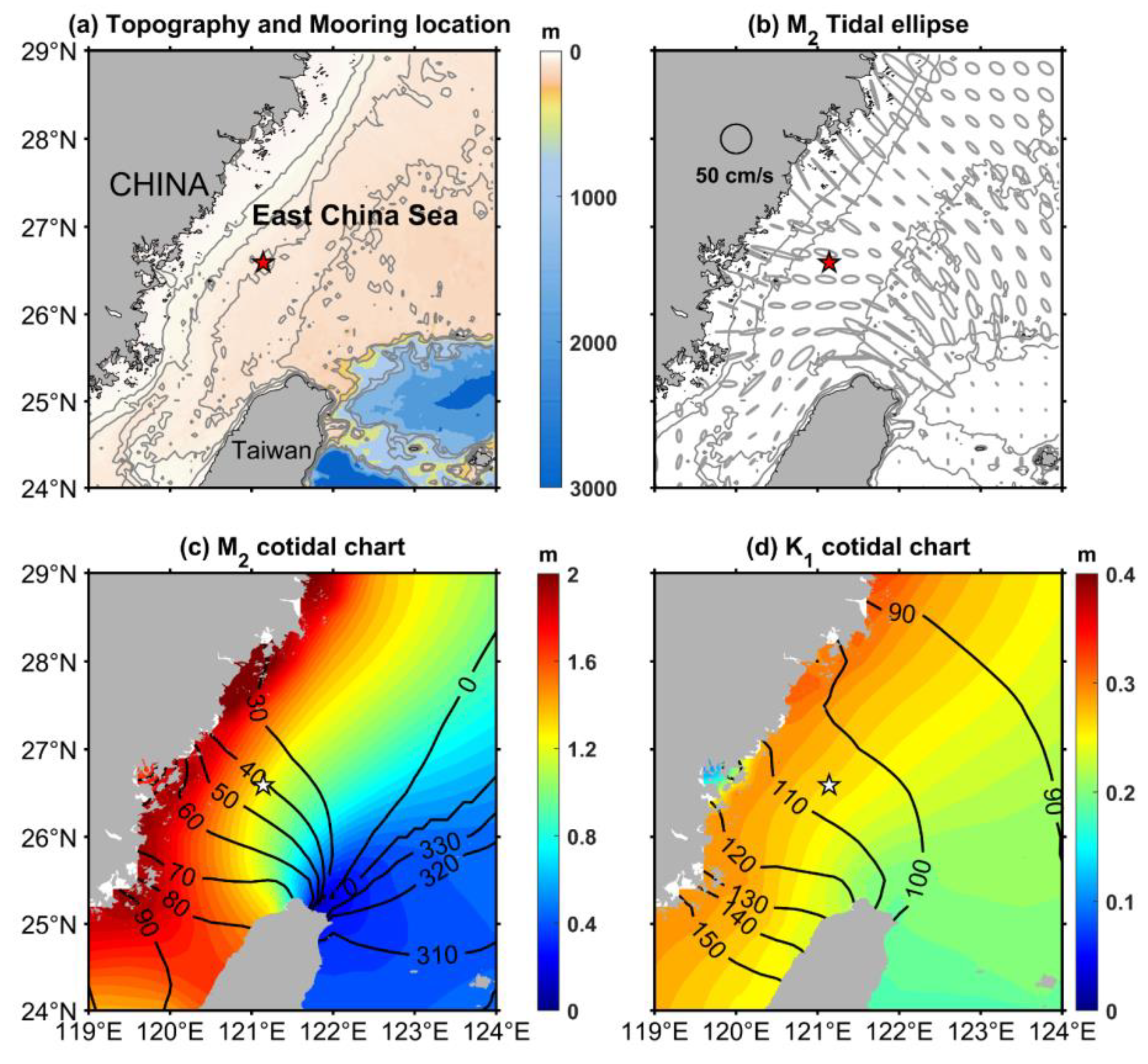
Figure 1. (a) Bathymetry for the East China Sea Shelf (color), with the mooring location (red star). The solid gray lines indicate the isobathic contours of 30, 50, 70, 100, 200, 800, and 1000 m (Smith and Sandwell 1/60° by 1/60°). (b) M2 tidal ellipse obtained from TPXO 7.2. Tidal ellipses (with major axes scaled to unit) are shown in gray at a grid spacing of 0.3° by 0.3°. The contours are the isobaths of 30, 50, 100, 200, and 1000 m. (c) M2 cotidal chart based on TPXO 7.2. The contours indicate the co-phase lines with interval of 10°, except at 330°, 0°, and 30° with interval of 30°. (d) K1 cotidal chart based on TPXO 7.2.
Remotesensing 14 02570 g001
Figure 2. (a) Full-depth averaged power spectra of the baroclinic zonal (red line) and meridional (blue line) velocities during the deployment period. The vertical dashed lines indicate the local Coriolis frequency f, four major tidal constituents (O1, K1, M2, S2), and some nonlinear couplings (fM2, M4, M2 + S2). (b) The internal tidal current ellipses for the four major tidal constituents (M2, S2, K1, and O1) at different depths.
Remotesensing 14 02570 g002
Figure 3. Time series of semidiurnal band baroclinic velocities (color, unit: m/s) derived from mooring observations from 29 May 2014 to 2 September 2014: (a) zonal component, (b) meridional component. (c) The vertically integrated current variance of baroclinic (blue) and local barotropic (M2 + S2) (red) tides predicted by TPXO 7.2.
Remotesensing 14 02570 g003
Figure 4. Same as in Figure 3 but for the diurnal baroclinic current and K1 + O1 barotropic tides.
Remotesensing 14 02570 g004
Figure 5. Comparison of monthly buoyancy frequency profiles from mooring (a) and slope (b).
Remotesensing 14 02570 g005
Figure 6. Body forces for (a) semidiurnal (M2) and (b) diurnal (K1) internal tides. The black solid lines indicate the 50, 200, and 1000 m isobaths. The red star indicates the mooring location. The red solid line indicates the possible propagation path of a remotely generated internal tide. The black box indicates the area of integration in Table 2. A1 (the upper box) represents the shelf generation region, A2 (the lower box) represents the slope generation region.
Remotesensing 14 02570 g006
Figure 7. SLA and geostrophic currents during (ac) three eddy periods and (d) a calm time. Time series of depth-integrated (e) semidiurnal and (g) diurnal baroclinic current variance in first three modes (stacked colors) by 14-day moving overlapped EOFs, and their respective proportions of the first eight EOF modes (f,h).
Remotesensing 14 02570 g007
Figure 8. Monthly-mean effective latitude (θeff) maps for June (a), July (b), and August (c) were calculated based on the effective Coriolis frequency (feff = f + ζ/2) and the formula (feff = 2Ωsinθeff). (d) Hovmöller Diagrams of effective latitude along the propagation path of diurnal internal tide (red line shown in Figure 6 and Figure 8a–c. The contours indicate the effective latitude. X-axis represents time, and Y-axis the geographical latitude. The red and black lines represent the critical latitudes for the O1 (27.6°) and K1 (30°) internal tides, respectively. (e) The time series of diurnal internal tide. The vertically integrated current variance of diurnal baroclinic (blue) and barotropic (K1 + O1) (red) tides are the same as in Figure 4c. Time lag (unit: days) of each baroclinic peak to the barotropic peak are labeled and remarked with black double arrows.
Remotesensing 14 02570 g008
Figure 9. (a) Wavelet power spectra of baroclinic zonal component during observation period at 60 m depth. The white dashed line indicates the cone of influence. The white dashed lines and the shaded regions below are suspect and potentially influenced by edge effects. The frequency unit is cycles per day (cpd), and the spectrum uses L1 normalization to show a more accurate representation of the signal. (b) The vertical profile of 7-day low-pass vertical shear variance (unit: 1/s2).
Remotesensing 14 02570 g009
Figure 10. (a) Cumulative travel time of diurnal (K1 + O1) internal tides and semidiurnal (M2 + S2) internal tides along the propagation path of internal tide. The path is the same as the one shown in (Figure 6, Figure 8, and Figure 10b), except ahead of the starting point to mooring location. The travel times are estimated by group velocity of K1 + O1 and M2 + S2 waves using WOA 18 monthly-mean stratification. The dash lines indicate the travel times considering the monthly mean background current of the month with the same color as solid lines. The mooring location, A1 and A2 demarcation lines (same as Figure 6) are marked for reference. (b) The schematic of the travel times along the propagation path. Semidiurnal and diurnal internal tide travel times in August (Unit: days) are labeled in blue and red as reference, respectively.
Remotesensing 14 02570 g010
Figure 11. Calculation of the M2 tidal beam reflections on the continental shelf from the slope area to mooring (white pentagram). The color indicates monthly climatology stratification derived from the WOA18 data. The black solid lines indicate the ray tracks of tidal beams, based on the formula ( tan θ = ( ω 2 f 2 ) / ( N 2 ω 2 ) ). The color dots indicate the bathymetry criticality α = H tan θ . The ray tracks are presented in (a) June, (b) July and (c) August.
Remotesensing 14 02570 g011
Figure 12. Same as in Figure 11, but for the K1 tidal beam.
Remotesensing 14 02570 g012
Figure 13. Bathymetry criticality (α) for (a) M2 and (b) K1 tidal constituents.
Remotesensing 14 02570 g013
Table 1. Ellipse properties of the major semidiurnal and diurnal barotropic tidal constituents at the mooring location.
ConstituentMajor, cm/sMinor, cm/sInclination, DegPhase 1, Deg
M255.018.9176.5336
S216.87.5169.56.3
K15.052.2817034
O14.80.721117
1 The ‘Phase’ indicated in table is Greenwich Phase.
Table 2. Integration of M2 and K1 body forces in the generation domain (black box shown in Figure 5) for each month.
JuneJulyAugust
Value (m2/s2)Value (m2/s2)Increasing Rate 1 (%)Value (m2/s2)Increasing Rate 2 (%)
M2 all4462528118.35548622.95
M2 in A1893111725.22123051.12
M2 in A23569416416.67425619.25
K1 all1104129717.50134822.09
K1 in A121326624.8829337.56
K1 in A2891103115.71105518.41
1,2 Increasing rates indicate July-on-June ratio, August-on-June ratio, respectively.
Publisher’s Note: MDPI stays neutral with regard to jurisdictional claims in published maps and institutional affiliations.