Article

Integration of VIIRS Observations with GEDI-Lidar Measurements to Monitor Forest Structure Dynamics from 2013 to 2020 across the Conterminous United States

1
Department of Geographical Sciences, University of Maryland, College Park, MD 20742, USA
2
U.S. Forest Service, 507-25th Street, Ogden, UT 84401, USA
3
NOAA-NESDIS Center for Satellite Applications and Research (STAR), 5830 University Research Court, College Park, MD 20740, USA
*
Author to whom correspondence should be addressed.
Remote Sens. 2022, 14(10), 2320; https://doi.org/10.3390/rs14102320
Submission received: 14 March 2022 / Revised: 7 May 2022 / Accepted: 7 May 2022 / Published: 11 May 2022
(This article belongs to the Special Issue Forest Monitoring in a Multi-Sensor Approach)

Abstract

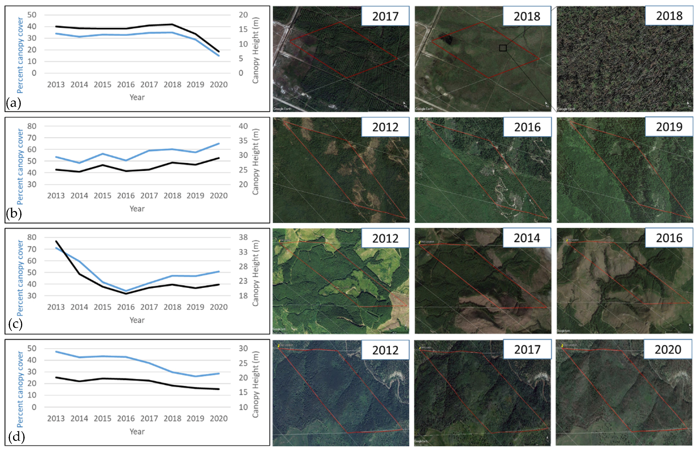
Consistent and spatially explicit periodic monitoring of forest structure is essential for estimating forest-related carbon emissions, analyzing forest degradation, and supporting sustainable forest management policies. To date, few products are available that allow for continental to global operational monitoring of changes in canopy structure. In this study, we explored the synergy between the NASA’s spaceborne Global Ecosystem Dynamics Investigation (GEDI) waveform LiDAR and the Visible Infrared Imaging Radiometer Suite (VIIRS) data to produce spatially explicit and consistent annual maps of canopy height (CH), percent canopy cover (PCC), plant area index (PAI), and foliage height diversity (FHD) across the conterminous United States (CONUS) at a 1-km resolution for 2013–2020. The accuracies of the annual maps were assessed using forest structure attribute derived from airborne laser scanning (ALS) data acquired between 2013 and 2020 for the 48 National Ecological Observatory Network (NEON) field sites distributed across the CONUS. The root mean square error (RMSE) values of the annual canopy height maps as compared with the ALS reference data varied from a minimum of 3.31-m for 2020 to a maximum of 4.19-m for 2017. Similarly, the RMSE values for PCC ranged between 8% (2020) and 11% (all other years). Qualitative evaluations of the annual maps using time series of very high-resolution images further suggested that the VIIRS-derived products could capture both large and “more” subtle changes in forest structure associated with partial harvesting, wind damage, wildfires, and other environmental stresses. The methods developed in this study are expected to enable multi-decadal analysis of forest structure and its dynamics using consistent satellite observations from moderate resolution sensors such as VIIRS onboard JPSS satellites.
Keywords: VIIRS-NOAA 20; GEDI Ecosystem LiDAR; vegetation 3D structure; random forest regression models; airborne discrete return LiDAR; accuracy assessment VIIRS-NOAA 20; GEDI Ecosystem LiDAR; vegetation 3D structure; random forest regression models; airborne discrete return LiDAR; accuracy assessment