
Validity of the AdMos, Advanced Sport Instruments, GNSS Sensor for Use in Alpine Skiing

 , and
, and
Abstract
:1. Introduction
2. Materials and Methods
2.1. Data Acquisition and Subjects
2.2. Materials
2.2.1. AdMos Receiver
2.2.2. Ground Truth System
2.3. Data Processing
2.3.1. GNSS Processing
2.3.2. Data Inclusion
2.3.3. Calculation of Skiing Characteristics
2.3.4. Accuracy Assessment
2.3.5. Statistics
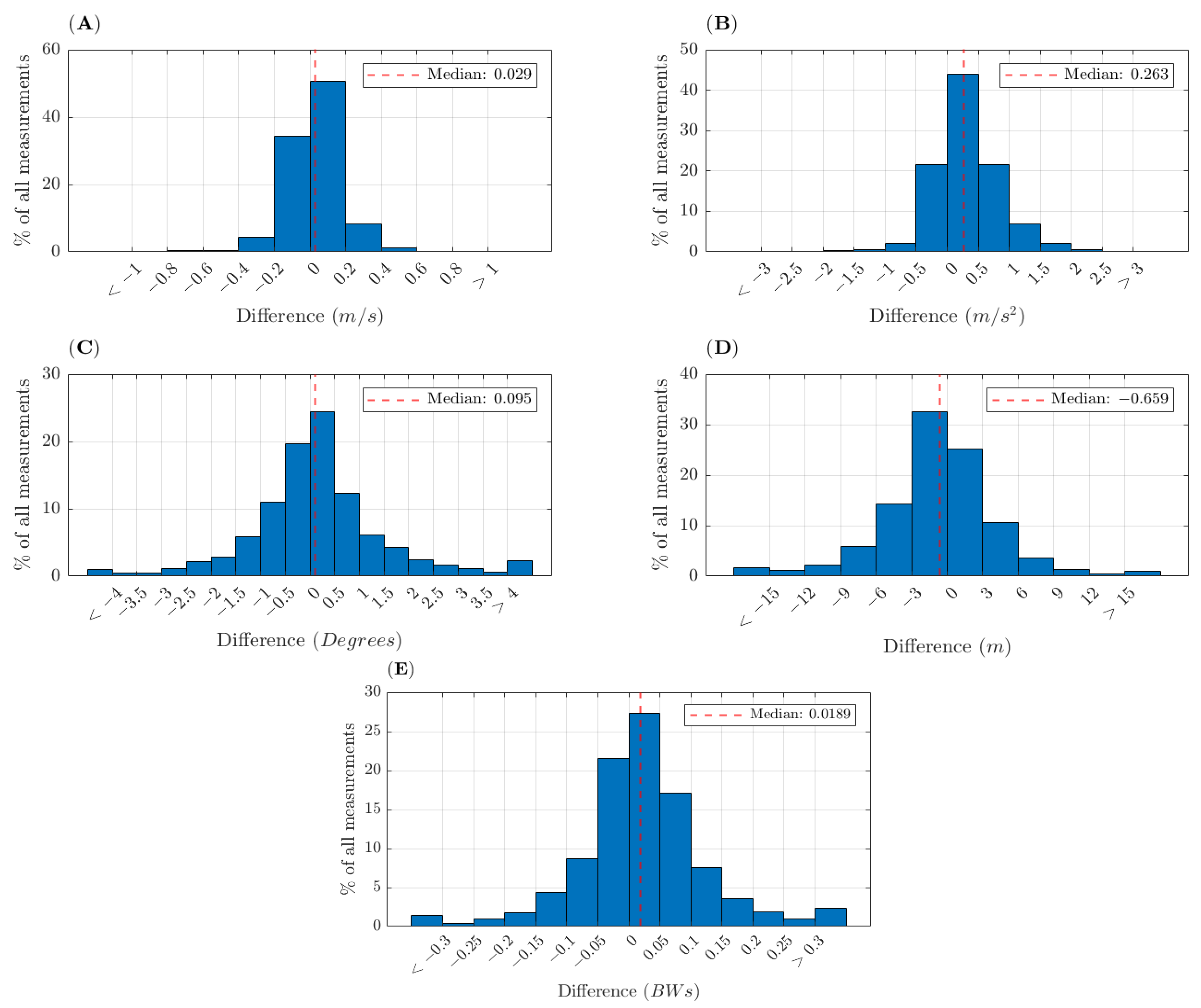
3. Results
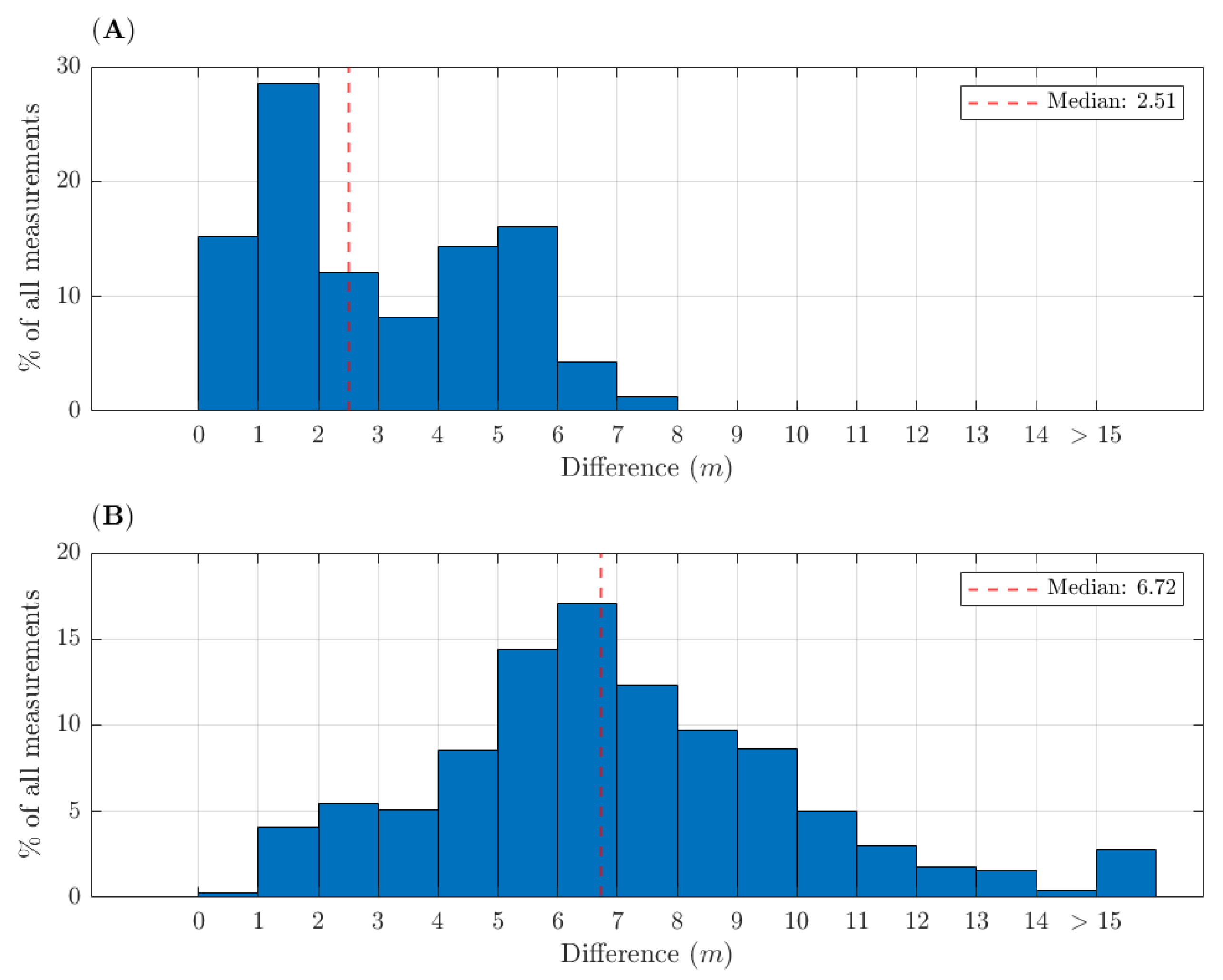
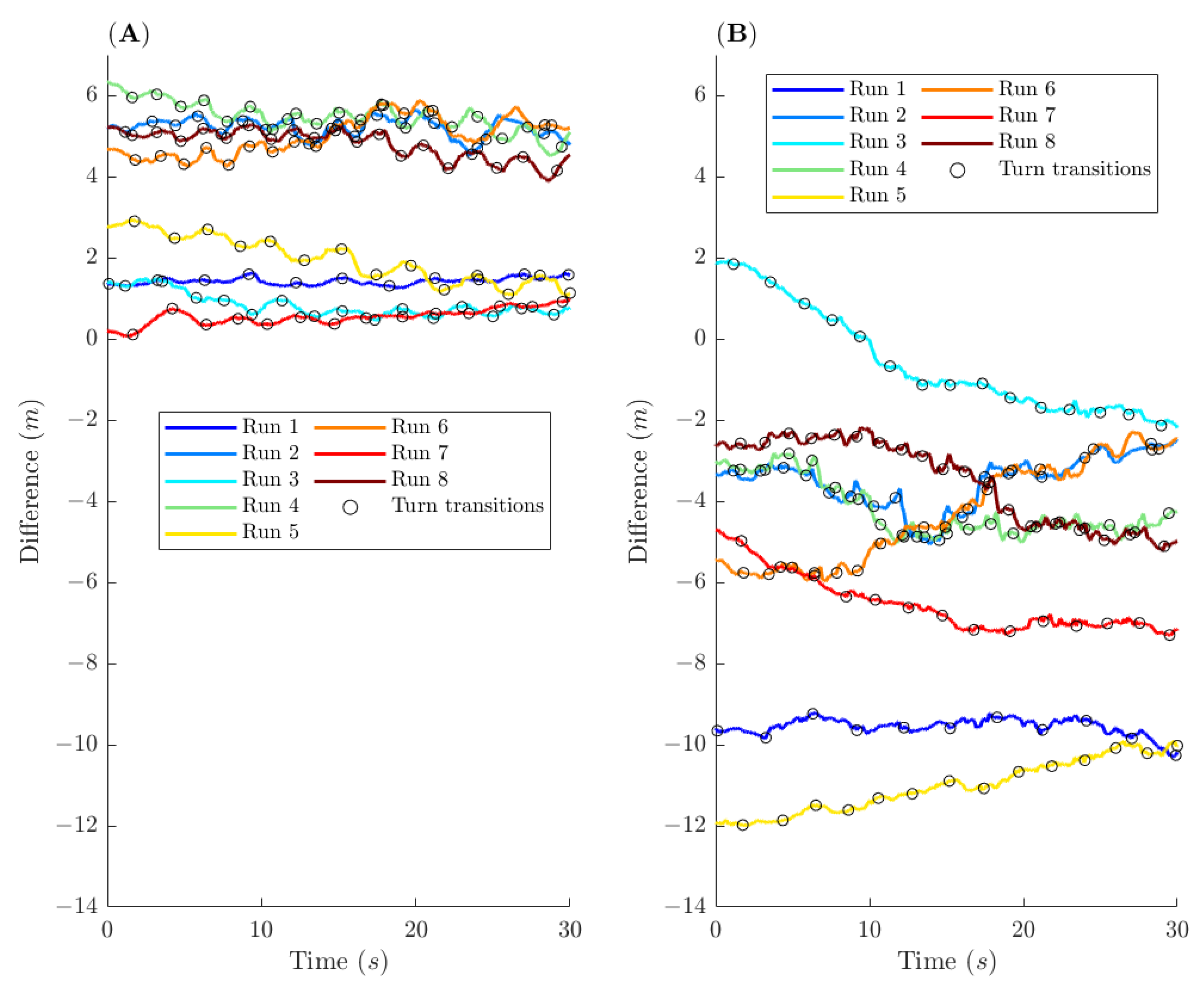
Position Errors
4. Discussion
4.1. Position Errors
4.2. Error of Instantaneous Skiing Characteristics
4.3. Error for Turn-Average Skiing Characteristics, and for Number of Turns and Impulse per Run
4.4. Transfer of the Findings of This Study to Other Sports
4.5. Limitations
5. Conclusions
Author Contributions
Funding
Institutional Review Board Statement
Informed Consent Statement
Data Availability Statement
Conflicts of Interest
References
- Federolf, P. Quantifying instantaneous performance in alpine ski racing. J. Sports Sci. 2012, 30, 1063–1068. [Google Scholar] [CrossRef] [Green Version]
- Delhaye, C.; Cross, M.R.; Bowen, M.; Samozino, P.; Hintzy, F. Influence of Line Strategy between Two Turns on Performance in Giant Slalom. Front. Sport. Act. Living 2020, 2, 175. [Google Scholar] [CrossRef] [PubMed]
- Spörri, J.; Kröll, J.; Schwameder, H.; Müller, E. The role of path length- and speed-related factors for the enhancement of section performance in alpine giant slalom. Eur. J. Sport Sci. 2018, 18, 911–919. [Google Scholar] [CrossRef] [PubMed] [Green Version]
- Gilgien, M.; Kröll, J.; Spörri, J.; Crivelli, P.; Müller, E. Application of dGNSS in alpine ski racing: Basis for evaluating physical demands and safety. Front. Physiol. 2018, 9, 145. [Google Scholar] [CrossRef] [Green Version]
- Supej, M.; Saetran, L.; Oggiano, L.; Ettema, G.; Šarabon, N.; Nemec, B.; Holmberg, H.-C.C.; Saarabon, N.; Nemec, B.; Holmberg, H.-C.C. Aerodynamic drag is not the major determinant of performance during giant slalom skiing at the elite level. Scand. J. Med. Sci. Sports 2012, 23, 38–47. [Google Scholar] [CrossRef]
- Meyer, F. Biomechanical Analysis of Alpine Skiers Performing Giant Slalom Turns. Ph.D. Thesis, University Lausanne, Lausanne, Switzerland, 2012. [Google Scholar]
- Reid, R.C. A kinematic and Kinetic Study of Alpine Skiing Technique in Slalom. Ph.D. Thesis, Norwegian School of Sport Sciences, Oslo, Norway, 2010. [Google Scholar]
- Gilgien, M.; Crivelli, P.; Spörri, J.; Kröll, J.; Müller, E. Characterization of course and terrain and their effect on skier speed in World Cup alpine ski racing. PLoS ONE 2015, 10, e0118119. [Google Scholar] [CrossRef] [Green Version]
- Gilgien, M.; Crivelli, P.; Kröll, J.; Luteberget, L.S.; Müller, E.; Spörri, J. Injury prevention in Super-G alpine ski racing through course design. Sci. Rep. 2021, 11, 3637. [Google Scholar] [CrossRef]
- Gilgien, M.; Crivelli, P.; Kröll, J.; Luteberget, L.S.; Müller, E.; Spörri, J. Preventing injuries in alpine skiing giant slalom by shortening the vertical distance between the gates rather than increasing the horizontal gate offset to control speed. Br. J. Sports Med. 2020, 54, 1042–1046. [Google Scholar] [CrossRef]
- Spörri, J.; Kröll, J.; Schwameder, H.; Schiefermüller, C.; Müller, E. Course setting and selected biomechanical variables related to injury risk in alpine ski racing: An explorative case study. Br. J. Sports Med. 2012, 46, 1072–1077. [Google Scholar] [CrossRef] [Green Version]
- Supej, M.; Nemec, B.; Kugovnik, O. Changing conditions on the slalom ski course affect competitors’ performances. Kinesiology 2005, 37, 151–158. [Google Scholar]
- Schiestl, M.; Kaps, P.; Mossner, M.; Nachbauer, W. Calculation of friction and reaction forces during an alpine world cup downhill race. In The Engineering of Sport 6; Moritz, E.F., Haake, S., Eds.; Springer: New York, NY, USA, 2006; Volume 1, pp. 269–274. [Google Scholar]
- Spörri, J.; Kröll, J.; Gilgien, M.; Müller, E. Sidecut radius and the mechanics of turning: Equipment designed to reduce risk of severe traumatic knee injuries in alpine giant slalom ski racing. Br. J. Sports Med. 2016, 50, 14–19. [Google Scholar] [CrossRef] [PubMed] [Green Version]
- Gilgien, M.; Spörri, J.; Limpach, P.; Geiger, A.; Müller, E. The Effect of Different Global Navigation Satellite System Methods on Positioning Accuracy in Elite Alpine Skiing. Sensors 2014, 14, 18433–18453. [Google Scholar] [CrossRef] [PubMed] [Green Version]
- Supej, M.; Holmberg, H.C. A new time measurement method using a high-end global navigation satellite system to analyze alpine skiing. Res. Q. Exerc. Sport 2011, 82, 400–411. [Google Scholar] [CrossRef] [PubMed]
- Gilgien, M.; Spörri, J.; Kröll, J.; Müller, E. Effect of ski geometry and standing height on kinetic energy: Equipment designed to reduce risk of severe traumatic injuries in alpine downhill ski racing. Br. J. Sports Med. 2016, 50, 8–13. [Google Scholar] [CrossRef] [PubMed] [Green Version]
- Supej, M.; Nedergaard, N.J.; Nord, J.; Holmberg, H.C. The impact of start strategy on start performance in alpine skiing exists on flat, but not on steep inclines. J. Sports Sci. 2019, 37, 647–655. [Google Scholar] [CrossRef] [PubMed]
- Fasel, B.; Spörri, J.; Gilgien, M.; Boffi, G.; Chardonnens, J.; Müller, E.; Aminian, K. Three-dimensional body and centre of mass kinematics in alpine ski racing using differential GNSS and inertial sensors. Remote Sens. 2016, 8, 671. [Google Scholar] [CrossRef] [Green Version]
- Nemec, B.; Petrič, T.; Babič, J.; Supej, M.; Petric, T.; Babic, J.; Supej, M. Estimation of alpine skier posture using machine learning techniques. Sensors 2014, 14, 18898–18914. [Google Scholar] [CrossRef] [Green Version]
- Supej, M.; Ogrin, J.; Šarabon, N.; Holmberg, H.C. Asymmetries in the technique and ground reaction forces of elite alpine skiers influence their slalom performance. Appl. Sci. 2020, 10, 7288. [Google Scholar] [CrossRef]
- Supej, M. 3D measurements of alpine skiing with an inertial sensor motion capture suit and GNSS RTK system. J. Sports Sci. 2010, 28, 759–769. [Google Scholar] [CrossRef]
- Lachapelle, G.; Morrison, A.; Ong, R. StealthTM-a-based advanced device to train Canadian olympic Skiers. Geomatica 2010, 64, 327–335. [Google Scholar]
- Gilgien, M.; Spörri, J.; Chardonnens, J.; Kröll, J.; Müller, E. Determination of external forces in alpine skiing using a differential global navigation satellite system. Sensors 2013, 13, 9821–9835. [Google Scholar] [CrossRef] [PubMed] [Green Version]
- Gilgien, M.; Spörri, J.; Kröll, J.; Crivelli, P.; Müller, E. Mechanics of turning and jumping and skier speed are associated with injury risk in men’s World Cup alpine skiing: A comparison between the competition disciplines. Br. J. Sports Med. 2014, 48, 742–747. [Google Scholar] [CrossRef] [PubMed] [Green Version]
- Zorko, M.; Nemec, B.; Babic, J.; Lesnik, B.; Supej, M. The Waist Width of Skis Influences the Kinematics of the Knee Joint in Alpine Skiing. J Sport. Sci. Med. 2015, 14, 606–619. [Google Scholar]
- Fasel, B.; Gilgien, M.; Spörri, J.; Aminian, K. A new training assessment method for alpine ski racing: Estimating center of mass trajectory by fusing inertial sensors with periodically available position anchor points. Front. Physiol. 2018, 9, 1203. [Google Scholar] [CrossRef] [PubMed]
- Brodie, M.; Walmsley, A.; Page, W. Fusion motion capture: A prototype system using inertial measurement units and GPS for the biomechanical analysis of ski racing. Sport. Technol. 2008, 1, 17–28. [Google Scholar] [CrossRef]
- Bruhin, B.; Janssen, R.J.F.; Guillaume, S.; Gander, M.; Oberle, F.; Lorenzetti, S.; Romann, M. Giant Slalom: Analysis of Course Setting, Steepness and Performance of Different Age Groups—A Pilot Study. Front. Sport. Act. Living 2020, 2, 107. [Google Scholar] [CrossRef] [PubMed]
- Cross, M.R.; Delhaye, C.; Morin, J.B.; Bowen, M.; Coulmy, N.; Hintzy, F.; Samozino, P. Force output in giant-slalom skiing: A practical model of force application effectiveness. PLoS ONE 2021, 16, e0244698. [Google Scholar] [CrossRef]
- Gløersen, Ø.; Kocbach, J.; Gilgien, M. Tracking performance in endurance racing sports: Evaluation of the accuracy offered by three commercial GNSS receivers aimed at the sports market. Front. Physiol. 2018, 9, 1425. [Google Scholar] [CrossRef] [PubMed] [Green Version]
- Skaloud, J.; Limpach, P. Synergy of CP-DGPS, Accelerometry and Magnetic Sensors for Precise Trajectography in Ski Racing. In Proceedings of the Conference of the ION GPS/GNSS 2003, Portland, OR, USA, 9–12 September 2003. [Google Scholar]
- Gilat, A.; Subramaniam, V. Numerical Methods for Engineers and Scientists; John Wiley & Sons, Inc.: Hoboken, NJ, USA, 2008. [Google Scholar]
- Gløersen, Ø.; Gilgien, M. Classification of Cross-Country Ski Skating Sub-Technique Can Be Automated Using Carrier-Phase Differential GNSS Measurements of the Head’s Position. Sensors 2021, 21, 2705. [Google Scholar] [CrossRef]
- Luteberget, L.; Spencer, M.; Gilgien, M. Validity of the Catapult ClearSky T6 local positioning system for team sports specific drills, in indoor conditions. Front. Physiol. 2018, 9, 115. [Google Scholar] [CrossRef] [Green Version]
- Supej, M.; Kipp, R.; Holmberg, H.C. Mechanical parameters as predictors of performance in alpine World Cup slalom racing. Scand. J. Med. Sci. Sports 2010, 21, e72–e81. [Google Scholar] [CrossRef]
- Spörri, J.; Kröll, J.; Gilgien, M.; Müller, E. How to prevent injuries in alpine ski racing: What do we know and where do we go from here? Sport. Med. 2016, 47, 599–614. [Google Scholar] [CrossRef] [Green Version]
- Spörri, J.; Kröll, J.; Fasel, B.; Aminian, K.; Müller, E. The use of body worn sensors for detecting the vibrations acting on the lower back in alpine ski racing. Front. Physiol. 2017, 8, 522. [Google Scholar] [CrossRef]
- Supej, M.; Ogrin, J.; Holmberg, H.C. Whole-body vibrations associated with alpine skiing: A risk factor for low back pain? Front. Physiol. 2018, 9, 204. [Google Scholar] [CrossRef]
- Nakazato, K.; Scheiber, P.; Müller, E. A comparison of ground reaction forces determined by portable force-plate and pressure-insole systems in alpine skiing. J. Sport. Sci. Med. 2011, 10, 754–762. [Google Scholar]
- Supej, M.; Hebert-Losier, K.; Holmberg, H.C. Impact of the Steepness of the Slope on the Biomechanics of World Cup Slalom Skiers. Int. J. Sports Physiol. Perform. 2015, 10, 361–368. [Google Scholar] [CrossRef]
- Ogrin, J.; Šarabon, N.; Madsen, M.K.; Kersting, U.; Holmberg, H.-C.; Supej, M. Asymmetries in Ground Reaction Forces during Turns by Elite Slalom Alpine Skiers Are Not Related to Asymmetries in Muscular Strength. Front. Physiol. 2021, 12, 431. [Google Scholar] [CrossRef] [PubMed]
- Spörri, J.; Kröll, J.; Schwameder, H.; Müller, E. Turn Characteristics of a Top World Class Athlete in Giant Slalom: A Case Study Assessing Current Performance Prediction Concepts. Int. J. Sport. Sci. Coach. 2012, 7, 647–660. [Google Scholar] [CrossRef]
- Kröll, J.; Spörri, J.; Gilgien, M.; Schwameder, H.; Müller, E. Effect of ski geometry on aggressive ski behaviour and visual aesthetics: Equipment designed to reduce risk of severe traumatic knee injuries in alpine giant slalom ski racing. Br. J. Sports Med. 2016, 50, 20–25. [Google Scholar] [CrossRef] [Green Version]
- Karlsson, Ø.; Gilgien, M.; Gløersen, Ø.N.; Rud, B.; Losnegard, T. Exercise Intensity During Cross-Country Skiing De-scribed by Oxygen Demands in Flat and Uphill Terrain. Front. Physiol. 2018, 9, 846. [Google Scholar] [CrossRef]
- Sollie, O.; Gløersen, Ø.; Gilgien, M.; Losnegard, T. Differences in pacing pattern and sub-technique selection between young and adult competitive cross-country skiers. Scand. J. Med. Sci. Sports 2020, 31, 553–563. [Google Scholar] [CrossRef] [PubMed]
- Yamazaki, J.; Gilgien, M.; Kleiven, S.; Mcintosh, A.S.S.; Nachbauer, W.; Müller, E.; Bere, T.; Bahr, R.; Krosshaug, T. Analysis of a severe head injury in World Cup alpine skiing. Med. Sci. Sport. Exerc. 2015, 47, 1113–1118. [Google Scholar] [CrossRef] [PubMed] [Green Version]
- Gilgien, M.; Spörri, J.; Chardonnens, J.; Kröll, J.; Limpach, P.; Müller, E. Determination of the centre of mass kinematics in alpine skiing using differential global navigation satellite systems. J. Sports Sci. 2015, 33, 960–969. [Google Scholar] [CrossRef] [PubMed]


| Competitive Skiing | Recreational Skiing * | Recreational Skiing ** | |
|---|---|---|---|
| Performance Level | Europa Cup | Retired FIS Athlete | Recreational Skier |
| Age (years) | 24 | 24 | 44 |
| Weight (kg) | 86 | 70 | 72 |
| Height (cm) | 182 | 176 | 180 |
| Competitive Skiing | Recreational Skiing | Sum of All Skiing Data | ||
|---|---|---|---|---|
| Runs | 27 | 63 | 90 | |
| Turns | 844 | 2505 | 3349 | |
| Total distance (km) | 21.74 | 38.91 | 60.65 | |
| Distance/run (m) | Mean ± SD | 805 ± 327 | 618 ± 342 | 674 ± 347 |
| Turns/run | Mean ± SD | 31 ± 10 | 40 ± 19 | 37 ± 18 |
| Time/run (s) | Mean ± SD | 63.2 ± 23.2 | 60.4 ± 31.0 | 60.6 ± 29.0 |
| |v| (m/s) | Mean | 12.74 | 10.85 | 11.46 |
| SD | 6.98 | 3.68 | 5.07 | |
| Max | 27.22 | 19.04 | 27.22 | |
| |a| (m/s2) | Mean | 6.10 | 5.32 | 5.97 |
| SD | 4.59 | 3.59 | 3.94 | |
| Incline (degrees) | Mean | 12.61 | 12.31 | 12.41 |
| SD | 6.91 | 8.01 | 7.68 | |
| Turn radius (m) | Mean | 32.74 | 31.22 | 31.73 |
| SD | 23.94 | 24.47 | 25.66 |
| Competitive Skiing | Recreational Skiing | ||
|---|---|---|---|
| ΔXY (m) | Median | 3.54 [3.50, 3.59] | 2.21 [2.19, 2.24] |
| IQR | 3.50 | 3.30 | |
| 90th percentile | [0.69, 6.27] | [0.57, 5.97] | |
| Δmax | 8.00 | 8.90 | |
| ΔXYZ (m) | Median | 6.49 [6.47, 6.51] | 7.01 [6.99, 7.04] |
| IQR | 2.30 | 4.30 | |
| 90th percentile | [2.44, 10.07] | [2.03, 13.71] | |
| Δmax | 12.40 | 50.90 |
| Competitive Skiing | Recreational Skiing | ||||
|---|---|---|---|---|---|
| Value | Percentage (%) | Value | Percentage (%) | ||
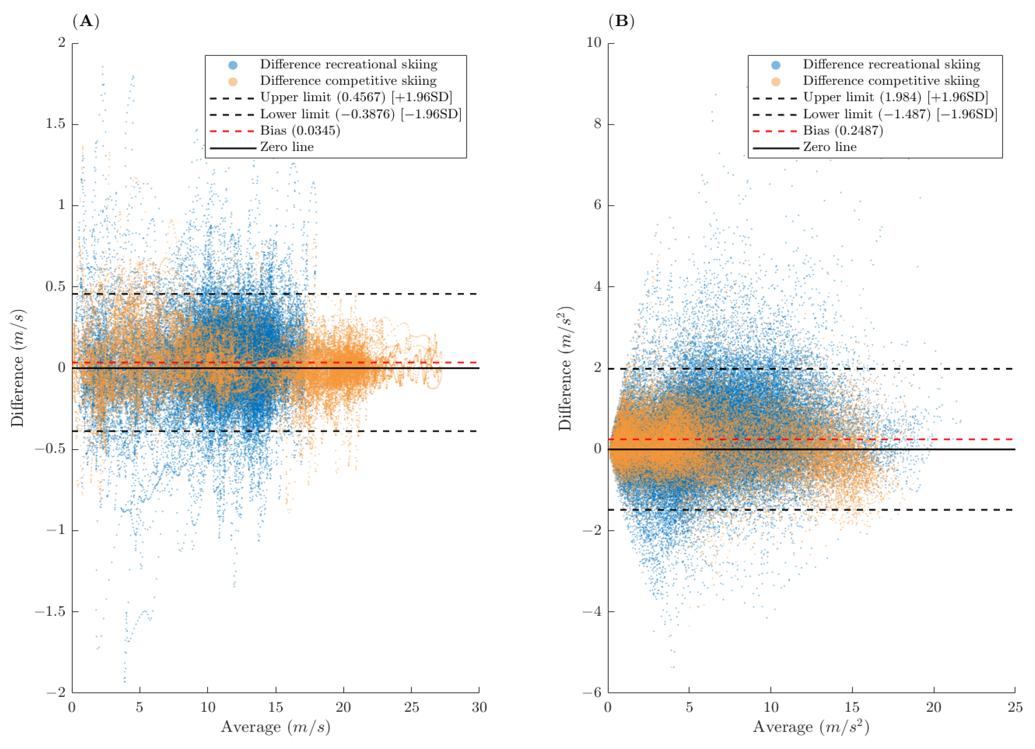
| Δ|v| (m/s) | Median | 0.015 [0.013, 0.016] | +0.1 | 0.037 [0.036, 0.039] | +0.3 |
| IQR | 0.18 | 1.4 | 0.23 | 2.0 | |
| 90th percentile | [−0.23, 0.34] | - | [−0.32, 0.39] | - | |
| Δmax | 0.89 | 92.3 | 1.93 | 69.6 | |
| Δ|a| (m/s2) | Median | 0.119 [0.111, 0.126] | +2.5 | 0.229 [0.222, 0.236] | +4.3 |
| IQR | 0.82 | 17.4 | 1.05 | 19.8 | |
| 90th percentile | [−0.94, 1.28] | - | [−1.09, 1.90] | - | |
| Δmax | 5.36 | 95.2 | 5.36 | 100 | |
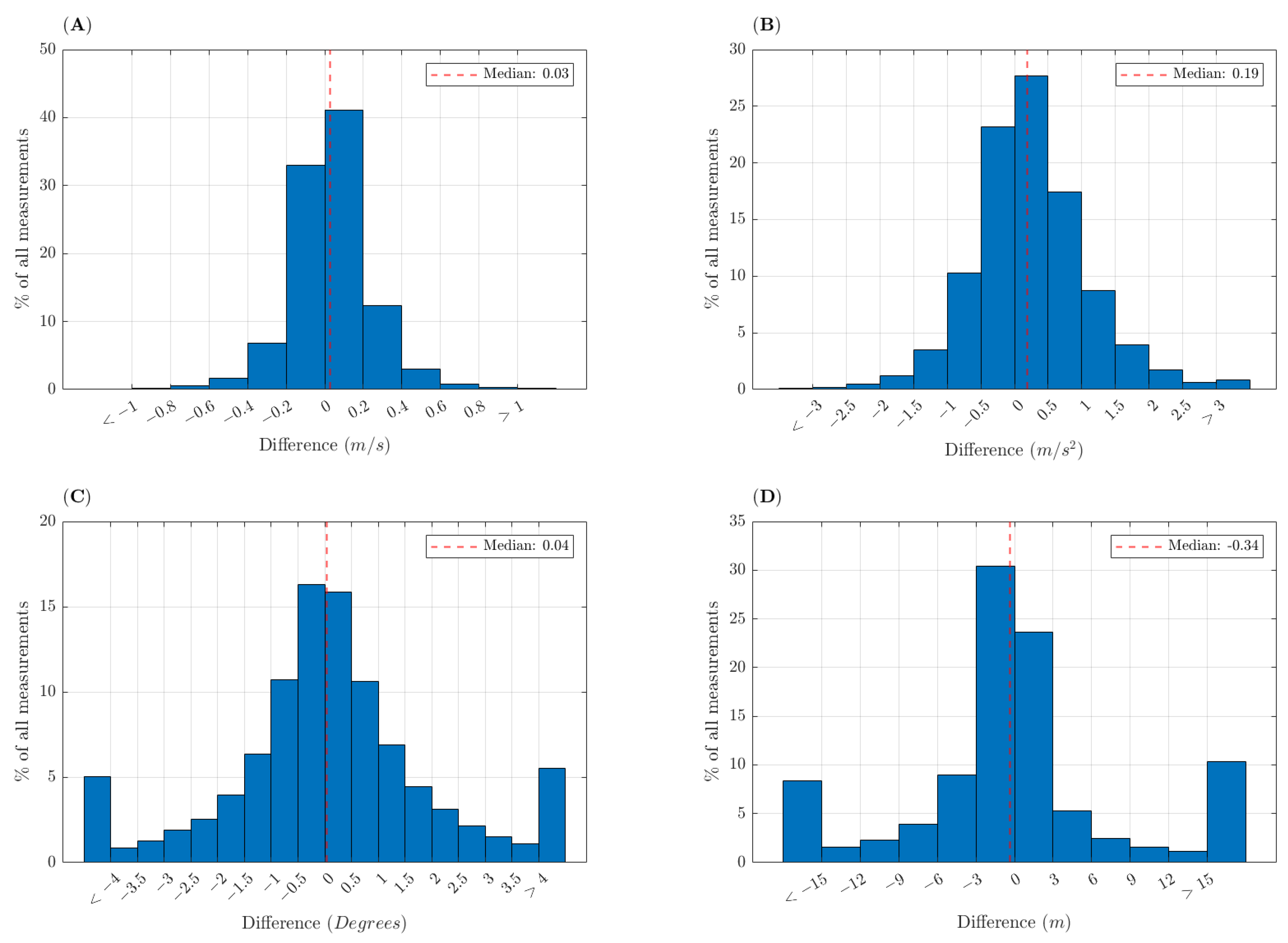
| ΔIncline (degrees) | Median | 0.042 [0.028, 0.053] | +0.3 | 0.026 [0.014, 0.036] | +0.1 |
| IQR | 1.51 | 10.8 | 1.95 | 15.6 | |
| 90th percentile | [−4.15, 4.94] | - | [−3.99, 4.05] | - | |
| Δmax | n.d | n.d | n.d | n.d | |
| ΔTurn radius (m) | Median | −0.11 [−0.14, −0.08] | −0.4 | −0.47 [−0.50, −0.44] | −2.3 |
| IQR | 3.9 | 14.2 | 5.64 | 27.2 | |
| 90th percentile | [−19.8, 29.1] | - | [−30.5, 65.2] | - | |
| Δmax | n.d | n.d | n.d | n.d | |
| Competitive Skiing | Recreational Skiing | ||||
|---|---|---|---|---|---|
| Value | Percentage (%) | Value | Percentage (%) | ||
| Δ|v|/Turn (m/s) | Median | −0.006 [−0.013, 0.003] | −0.04 | 0.039 [0.034, 0.047] | 0.34 |
| IQR | 0.13 | 0.82 | 0.16 | 1.40 | |
| 90th p.* | [−0.17, 0.18] | - | [−0.23, 0.29] | - | |
| Δmax | 0.45 | 6.32 | 1.39 | 38.9 | |
| Δ|a|/Turn (m/s2) | Median | 0.070 [0.046, 0.098] | 0.84 | 0.346 [0.319, 0.372] | 4.86 |
| IQR | 0.35 | 4.09 | 0.62 | 8.72 | |
| 90th p.* | [−0.40, 0.61] | - | [−0.37, 1.36] | - | |
| Δmax | 1.38 | 41.6 | 4.40 | 55.9 | |
| Δ Incline/Turn (degrees) | Median | 0.138 [0.097, 0.195] | 0.97 | 0.071 [0.027, 0.120] | 0.50 |
| IQR | 0.73 | 5.17 | 1.41 | 9.91 | |
| 90th p.* | [−1.24, 2.08] | - | [−2.24, 2.80] | - | |
| Δmax | 9.05 | 52.7 | 19.0 | 623 | |
| Δ Turn radius/Turn (m) | Median | −0.437 [−0.727, −0.256] | −1.20 | −0.716 [−0.940, −0.565] | −2.27 |
| IQR | 3.55 | 9.76 | 5.22 | 16.6 | |
| 90th p.* | [−5.38, 4.41] | - | [−9.82, 7.07] | - | |
| Δmax | 103 | 517 | 66.2 | 144 | |
| Δ Impulse/Turn (BWs) | Median | 0.008 [0.002, 0.013] | 0.30 | 0.024 [0.020, 0.028] | 1.57 |
| IQR | 0.086 | 3.44 | 0.098 | 6.54 | |
| 90th p.* | [−0.13, 0.17] | - | [−0.15, 0.22] | - | |
| Δmax | 0.78 | 14.1 | 0.89 | 184 | |
| Competitive Skiing | Recreational Skiing | ||||
|---|---|---|---|---|---|
| Value | Percentage (%) | Value | Percentage (%) | ||
| ΔTurns/run | Median | 0 | 0 | 1 | 2.7 |
| IQR | 3 | 11 | 2 | 5.4 | |
| 90th percentile | [2.6, 6.2] | - | [−3, 8.2] | - | |
| ΔImpulse/run (BWs) | Median | 0.20 | 0.3 | 0.93 | 1.5 |
| IQR | 0.22 | 0.3 | 1.31 | 2.1 | |
| 90th percentile | [−0.01, 0.54] | - | [0.00, 2.62] | - | |
Publisher’s Note: MDPI stays neutral with regard to jurisdictional claims in published maps and institutional affiliations. |
© 2021 by the authors. Licensee MDPI, Basel, Switzerland. This article is an open access article distributed under the terms and conditions of the Creative Commons Attribution (CC BY) license (https://creativecommons.org/licenses/by/4.0/).
Share and Cite
Jølstad, P.A.H.; Reid, R.C.; Gjevestad, J.G.O.; Gilgien, M. Validity of the AdMos, Advanced Sport Instruments, GNSS Sensor for Use in Alpine Skiing. Remote Sens. 2022, 14, 22. https://doi.org/10.3390/rs14010022
Jølstad PAH, Reid RC, Gjevestad JGO, Gilgien M. Validity of the AdMos, Advanced Sport Instruments, GNSS Sensor for Use in Alpine Skiing. Remote Sensing. 2022; 14(1):22. https://doi.org/10.3390/rs14010022
Chicago/Turabian StyleJølstad, Petter Andre Husevåg, Robert Cortas Reid, Jon Glenn Omholt Gjevestad, and Matthias Gilgien. 2022. "Validity of the AdMos, Advanced Sport Instruments, GNSS Sensor for Use in Alpine Skiing" Remote Sensing 14, no. 1: 22. https://doi.org/10.3390/rs14010022
APA StyleJølstad, P. A. H., Reid, R. C., Gjevestad, J. G. O., & Gilgien, M. (2022). Validity of the AdMos, Advanced Sport Instruments, GNSS Sensor for Use in Alpine Skiing. Remote Sensing, 14(1), 22. https://doi.org/10.3390/rs14010022