Abstract
Climate change influences the vulnerability of urban populations worldwide. To improve their adaptive capacity, the implementation of nature-based solutions (NBS) in urban areas has been identified as an appropriate action, giving urban planning and development an important role towards climate change adaptation/mitigation and risk management and resilience. However, the importance of extensively applying NBS is still underestimated, especially regarding its potential to induce significantly positive environmental and socioeconomic impacts across cities. Concerning environmental impacts, monitoring and evaluation is an important step of NBS management, where earth observation (EO) can contribute. EO is known for providing valuable disaggregated data to assess the modifications caused by NBS implementation in terms of land cover, whereas the potential of EO to uncover the role of NBS in urban metabolism modifications (e.g., energy, water, and carbon fluxes and balances) still remains underexplored. This study reviews the EO potential in the monitoring and evaluation of NBS implementation in cities, indicating that satellite observations combined with data from complementary sources may provide an evidence-based approach in terms of NBS adaptive management. EO-based tools can be applied to assess NBS’ impacts on urban energy, water, and carbon balances, further improving our understanding of urban systems dynamics and supporting sustainable urbanization.
1. Introduction
Sustainable urbanization is one of the priority themes at the global level. Among others, it comprises a United Nations (UN) goal (Sustainable Development Goal 11) [1], as well as a prevailing action domain of the European Union (EU), connected with several policy-making initiatives and funding options (Horizon 2020, Urban Innovative Actions, etc.). In parallel, climate change remains a key global threat restricting the possibility for sustainability in each spatial context, including urban areas [2]. Towards addressing both abovementioned interconnected and complex challenges, sustainable and resilient planning and development practices are required to ensure liveable cities in a changing climate [3].
In this context, nature-based solutions (NBS) constitute a pertinent category of spatial practices, which are strongly adopted and supported by the European Commission (EC) and other international organizations as an innovative technique, creating a balance between built and natural systems [4]. However, NBS are still a vague concept, since they are related to different techniques and management approaches [5]. In this study, NBS are defined as locally adapted actions “inspired by, supported by or copied from nature” [6] (p. 4). Therefore, a large range of actions can be classified as NBS (e.g., green roof creation, tree planting, etc.), and NBS can be subcategorised into diverse types according to the adopted alternative classification approach [5,6]. Each of these actions can contribute to multiple goals [1,4,6], supporting societies in addressing a variety of challenges in sustainable and resilient ways [7]. Hence, NBS are expected to be widely disseminated and applied as common practices in the coming years.
Focusing on urban space, NBS rely on or create natural areas and features in and around cities to perform essential ecosystem services [8], which can promote all dimensions of sustainable urbanization. Specifically, NBS can contribute to the following multiscale interconnected challenges: (a) social dimension of sustainable urbanization [9], (b) economic development in urban areas [10], and (c) positive environmental impacts [5]. With regard to urban environmental benefits, these include air quality regulation, climate regulation, natural hazards management, water flow regulation, water purification and waste treatment, erosion regulation, green space management, pollination, etc. [6,11]. Consequently, the potential of widely implementing NBS in cities is expected to enable urban planning and development (UPD) to play an important role in climate change mitigation and adaptation, as well as in risk management and resilience [7,12,13].
However, NBS are not panacea, they entail their own limitations and risks, and may even lead to adverse effects [14,15]. Their management should be transdisciplinary [16], while there is usually need for combining them with other practices [17], such as society-based solutions [18], towards achieving the expected sustainable and resilient urban transformation. Additionally, the abovementioned NBS’ positive impacts should be verified in each case study through monitoring and evaluation stages (Figure 1), also providing evidence that retrofits the decision-making procedure with the respective outputs, resulting in adaptive management [19]. Thus, an intrinsic need of urban planners in both the public and private sectors is to establish a baseline and to monitor and evaluate the impacts of urban NBS interventions to ensure sustainable and resilient development in a changing climate [20]. Towards effective monitoring and evaluation, urban planners and relevant experts should select suitable, unbiased, and robust methodologies, which can be used to compare NBS implementation’s impacts on the initial planning goals.
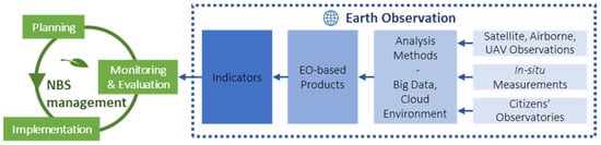
Figure 1.
The contribution of earth observation (EO) to nature-based solutions (NBS) management. EO contributes to NBS monitoring and evaluation, which is one of the main stages of NBS management, including planning and implementation in an adaptive cycle. EO data and products from various sources constitute the information source for scientific computing in cloud-based platforms, in order to achieve quantitative indicator products that can used by professionals in the NBS monitoring and evaluation procedure.
Regarding environmental impacts, only measurable evidence can ensure the long-term sustainability goals for cities worldwide [21]. Therefore, having repeatable, affordable, and effective environmental performance indicators is needed for methodological and accountability reasons. Especially for NBS, frequent monitoring and evaluation is crucial since they are dynamic, uncertain, and ever-evolving solutions based on ecosystem functions. NBS monitoring and evaluation can be applied through (bio-)indicator usage, ecosystem service valuation, impact assessments, or other approaches for checking the sustainability, resilience, and multi-functionality of established NBS. To this end, earth observation (EO) data and methods can be really enlightening, providing quantitative and systematic information about NBS performance. In particular, spaceborne sensing can be utilised to monitor the area of NBS intervention(s) for a continuous period, starting before the NBS implementation, in order to assess the state modifications of the area over time [15]. Except for detecting the modifications on urban form, EO has the potential to capture the impact of NBS on the hydro-meteorological conditions of urban areas [22]. For instance, specific alternations of urban energy balance (UEB) can be monitored for verifying specific microclimatic targets related to overheating mitigation, especially in case of heat waves, as these alternations can lead to multiple benefits, such as improving the outdoor thermal comfort of citizens [23].
Monitoring and evaluation approaches can provide tangible results about NBS efficiency and consequential multiple/multiscale benefits, hence promoting their transferability and wide application [11,22]. Depending on the considered monitoring and evaluation spatial scale, suitable EO approaches for capturing NBS impacts differ significantly, but overall, the underlying information needs to be captured on a finer scale than that of monitoring and evaluation. For example, quantifying the effect of individual NBS on a city block requires highly detailed EO data and appropriate methods, accordingly. Likewise, assessing the effect of NBS interventions on a city may involve analysis at the city block level for the whole urban extent, combined with city scale methods and EO data [24,25,26].
In general, environmental NBS monitoring and evaluation result in evidence capable of answering three key issues: (a) is the implemented NBS measure effective regarding addressing the problem? (b) Are the utilised NBS interventions more effective than other solutions? (c) How does the effectiveness change with local conditions? Many responses will vary according to the climate, local ecology, or societal variation [6]. Hence, the challenge is to systematically review the evidence, assess its relevance and quality, and then make it available to practitioners. EO can be rather crucial towards encountering this challenge, and this study aims at reviewing the potential of EO to set up an innovative and robust monitoring and evaluation scheme, monitor the performance for both short- and long-term periods, and quantitatively evaluate the impact of the deployed NBS against well-defined baselines of multiple scales. In particular, emphasis is put on both satellite and ancillary EO-based approaches, focusing on the estimation of the modifications caused by NBS to the urban energy fluxes and balances. In this context, the following content delineates the following: (a) NBS monitoring and evaluation methods, as well as relevant EO data and their sources (Section 2); (b) the results of various EO projects related to NBS monitoring and evaluation, centring on the estimation of UEB modification (Section 3); (c) the expected impacts and the future perspectives of EO towards adaptive NBS management (Section 4); and (d) the main conclusions of this study (Section 5).
2. Materials and Methods
In general, there are plenty of EO-based methods and relevant data (e.g., satellite, airborne, in situ, etc.) that can be deployed for monitoring and evaluation of NBS implementation. Focusing on spaceborne observations, they are capable of identifying land cover/use change on local scale [27], providing meaningful urban planning indicators for NBS implementation monitoring, retrieving spatial data of urban surface structure [28,29]; estimating urban change and sprawl [30]; and mapping the state of the urban surface before and after an intervention (e.g., green roofs) [31]. The spatial and temporal characteristics of the Copernicus Sentinels, designed to provide routine observations for multidisciplinary operational services, are suitable for addressing challenges associated with planning interventions in the urban environment, such as NBS. The Sentinels’ long-term observational commitment and their variety of instruments, including different spectral bands and spatial resolutions with global coverage and frequent observations, fit well for operational applications of urban planning indicators. The enhanced spectral and spatial characteristics, improved data quality, extended coverage, and frequent revisit times of the Sentinels are of major importance for NBS monitoring and evaluation. By combining observations deriving from the Sentinels’ optical (Sentinel-2 and Sentinel-3) and synthetic aperture radar (SAR) sensors (Sentinel-1), local scale products can be delivered with adequate frequency to support UPD activities [32].
Furthermore, commercial satellite missions can be exploited in NBS monitoring and evaluation when baseline data are not adequate. Pleiades constellation data, Terra SAR-X, CosmoSkyMED, as well as WorldView II and III are some examples of commercial sensors that can be used to obtain very high-resolution and improved quality information regarding urban structure [33] and land coverage. For instance, the retrieval of urban structure parameters (building structure, height to width ratio, sky view factor, etc.) requires very high-resolution digital surface models (DSM), which can be derived from very high-resolution optical or SAR stereo imagery. Many cities in developed countries have already produced DSM from very high-resolution data that are free in many cases. However, such data are often outdated or limited to a small part of the cities [28]. Moreover, in cities in developing countries, such data are scarce and should be produced in order to be used in some products. In these cases, commercial optical stereo imagery or SAR can be used to produce a baseline for the city in question and as an input to modeling efforts. Once the baseline is available, the temporal updates are then dependent on the forthcoming changes resulting from NBS or other interventions at the city or neighborhood level. In addition, micro-satellites, characterised by restricted cost and large constellations, have contributed to this direction, providing data with better spatial and temporal resolution. These data can correspond to multiple spatial levels and extended time periods, having the potential to efficiently assist the process of NBS monitoring and evaluation.
Several recently developed research EO-based approaches (methodologies, methods, techniques, etc.), which promote and enhance NBS monitoring and evaluation, can be summarized as follows (Table 1):

Table 1.
The outline of earth observation (EO) project cases, providing information regarding nature-based solutions (NBS). The NBS-related theme, scope, methodology, output, and scale for each project are delineated.
- The methodology developed by the BRIDGE project [24] uses a multi-criteria evaluation method for assessing urban planning alternatives, including NBS, using environmental, social, and economic indicators. EO methods were used to support the environmental modeling component with high-resolution visible infrared (VIS/IR) and thermal infrared (TIR) imagery and (very) high-resolution stereo imagery, retrieving information related to the surface physical properties (e.g., albedo, emissivity) and the urban morphology. This information is critical for assessing the NBS’ impact on the UEB, and thus on the local climatic conditions.
- The method developed by the DECUMANUS project [34] is able to detect green roofs by computing the slope of the building roofs using very high-resolution DSM and building outlines; and to assess the portion of the roofs covered with vegetation, using very high-resolution VIS/IR imagery. Moreover, this method, combined with a very high-resolution digital terrain model (DTM), is able to detect street trees. Hence, this approach is rather useful for specifying the location and the extent of key urban NBS interventions and providing input to spatial indicators (e.g., vegetation density).
- The methodology developed by URBANFLUXES project [35] combines (very) high-resolution satellite imagery, aerial derived DSM, and standard meteorological measurements. These EO datasets are deployed with modeling and other methods to assess urban energy fluxes and balance, which can be modified by the utilization of NBS. Therefore, this approach can be used to map any changes in UEB caused by NBS implementation (more details in Section 3.2).
- The techniques developed by GEOURBAN [36,37] and SEN4RUS projects [38,39] employ high-resolution VIS/IR and TIR, as well as very high-resolution radar and stereo imagery, to provide EO products (e.g., impervious areas fraction, aerosol optical depth, etc.). These products were incorporated into urban environmental indicators quantifying the density of green, blue, and (non) built-up areas, which are related to diverse urban NBS types and constitute their practice field.
- The UrbanNBS application, funded by the EOValue project [40], is a cloud-based tool, entailing methods that estimate the likelihood of green roofs and normalized difference vegetation index, capable of automatically detecting and monitoring green roofs by using time series of Sentinel-2 multispectral imagery and building footprints from open data sources (e.g., OpenStreetMap). Green roofs are a type of NBS widely adopted in many urban areas, and their identification and monitoring are required processes serving their adaptive management.
A combination of monitoring and evaluation approaches and technologies should be applied in many cases towards achieving more reliable results regarding NBS performance. Particularly, EO data can be combined with non-spatial data and innovative methods to obtain valuable urban planning indicators [28,29,41,42,43,44,45]. Sources of data can be databases deriving from the European Copernicus programme, Urban Atlas, OpenStreetMap, censuses, and other sources; in situ measurements from technologies applied in specific urban areas; and initiatives related to citizen science (Figure 1). Among open data repositories, the Copernicus programme is recognised as providing various types of useful data, sharing satellite and ground/air/sea-related measurements, as well as modelled parameters. This global and long-time range information is stored in robust databases, and feeds the five platforms of the Copernicus Data and Information Access Services (DIAS) corresponding to various thematic areas: atmosphere, marine, land, climate change, security, and emergency. Other online platforms are the Urban Thematic Exploitation Platform (U-TEP) of the European Space Agency (ESA) and the Google Earth Engine, providing data and tools capable of innovative (big) data processing [15]. On the other hand, in situ measurements can supplement databases’ information about NBS’ environmental impacts and result from technologically advanced tools, such as ground remote sensing, drones, and micrometeorological approaches [25,26,46]. Finally, citizen science initiatives, such as citizens’ observatories, can lead to efficient participatory monitoring and evaluation, enhancing data collection and analysis as well as open governance, although there are many challenges to be addressed [47].
All the abovementioned data have been greatly increased in recent years due to technological advancements forming an enormous bulk of information, which can be considered as big data. Big data can feed decision-making about NBS with the use of proper tools [48]. These tools deploy EO data and can be used in more than one case study supporting NBS-related decision-making. Such tools are multi-sensor fusion and time-series feature extraction techniques, which are currently evolving and have the potential to go beyond the current state-of-the-art [49]. In particular, techniques involving multi-temporal EO data can be considered as state-of-the-art classification methods, and can be used for creating urban morphology spatial datasets, such as building density and volume [50], as well as urban surface/air temperature [27,51,52]. Other tools include modeling capabilities, which can address different NBS impact assessment objectives: considering desired parameters, combining diverse input datasets, modifying observation scale, projecting impacts, defining scenarios, simulating alternative solutions, etc. Additionally, modeling tools have been updated with technologies emerged from other scientific fields (artificial intelligence, machine learning, etc.) for processing more input data in a more sophisticated way and can provide models for different applications and spatial scales (i.e., fine scale and local scale) [53].
3. Results
3.1. EO-Based Tools Capable of NBS Monitoring and Evaluation
As to research and innovation, there are many NBS projects adopting EO approaches as parts of their monitoring and evaluation methodologies, namely ThinkNature, NAIAD, Nature4Cities, NATURVATION, Connecting Nature, UNaLab, URBAN GreenUP, OPERANDUM, PHUSICOS, CLEVER Cities, ProGIreg, URBiNAT, REGREEN, etc. [54]. In addition, several EO projects have developed valuable monitoring and evaluation tools and can be deployed for specifying impacts of implemented NBS. Indicatively, the following projects are listed:
- BRIDGE (Sustainable Urban Planning Decision Support Accounting for Urban Metabolism)—The aim of this project was to link biophysical sciences with urban planning by demonstrating how planning alternatives impact on the urban metabolism (consuming and processing material and energy, as well as producing waste). A decision support system (DSS) was created for assessing the urban metabolism processes related to energy, water, carbon, and pollutant fluxes on the local scale in five European cities [24]. This DSS can aid urban planners in assessing the modification of urban metabolism caused by NBS application.
- DECUMANUS (Development and Consolidation of Geo-Spatial Sustainability Services for Adaptation and Environmental and Climate Change Urban Impacts)—The main objective of this project was to provide tools and services combining urban environmental and socio-economic data for addressing the societal challenges related to urban climate change adaptation and mitigation. Among others, the project developed and showcased EO-based applications related to NBS monitoring (i.e., green roof and tree detection services) [34].
- URBANFLUXES (Urban Anthropogenic Heat Flux from Earth Observation Satellites)—This project focused on the potential of EO to independently estimate the main components of the UEB on the local scale (100 m × 100 m) based on satellite, airborne, and in situ data. It aimed at better understanding urban climate processes, such as the urban heat island (UHI), and ultimately supporting sustainable urban planning strategies relevant to climate change mitigation and adaptation in cities, such as NBS [35].
- GEOURBAN (Earth Observation in Sustainable Urban Planning & Management)/SEN4RUS (Exploiting Sentinels for Supporting Urban Planning Applications at City and Regional Levels in Russia)—The aim of the GEOURBAN project was to establish a list of EO-based indicators for inclusion in planning practices [36,37]. The adaptation of the GEOURBAN methodology to the Copernicus Sentinels [38] was the main aim of the SEN4RUS project [39]. This project developed urban indicators estimating (among others) built-up, vegetation, and water density for many Russian cities (e.g., in Figure 2), which can also be used for NBS monitoring and evaluation.
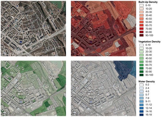 Figure 2. Evaluation of urban environmental indicators based on earth observation (EO) regarding built-up (upper right image), vegetation (lower left image), and water density (lower right image), using the SEN4RUS [39] approach. Here, an example of application in the city of Omsk, Russia is shown. Maps were created with QGIS software, version 3.4.4 (www.qgis.org, accessed on 21 November 2019). Maps data: Google, Maxar Technologies.
 - EOValue (Socio-Economic Value of EO Research)—This project funded (among others) the UrbanNBS application, which aims at monitoring the development of green roofs. Specifically, this web-based and cloud-supported application provides time series of indicators about green roofs from 2017 to date, in order to support decision-makers and urban planners in detecting and monitoring green roofs at the city level (Figure 3) [40].
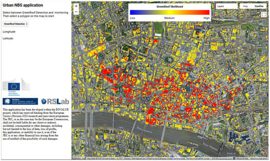 Figure 3. The UrbanNBS application [40] (https://davidparastatidis.users.earthengine.app/view/sentinel-2-nbs-monitoring-application, accessed on 22 December 2020). Here, the probability of rooftops featuring green roofs in central London, UK, in 2019 is shown.
 - CURE (Copernicus for Urban Resilience in Europe)—This is an ongoing project aiming to synergistically exploit Copernicus Core Services to develop cross-cutting applications for urban resilience in several European cities. CURE will be able to provide urban planners and decision-makers with spatially disaggregated environmental information on local scale [55], including NBS performance related to key resilience challenges (i.e., heat stress, flooding, ground movements, air pollution, etc.).
3.2. Monitoring UEB Changes Caused by NBS Implementation
Τhe behavior of climate-related parameters in time and space, deriving from modern satellite data time series (such as Copernicus Sentinels) and other auxiliary sources (e.g., in situ meteorological stations), constitutes excellent information for studying their dependence on the city structure and the land use/cover changes caused by NBS implementation. Additionally, this type of combined information provides insights about changes aggravating unwanted climatic effects, and specifies the consequences of urban climate change on the local scale due to the dependence of local climate on the local surface characteristics and on the distribution of the UEB fluxes.
NBS can serve as a planning tool towards achieving UPD targets related to UEB. Therefore, urban planners should be able to quantitatively estimate how the local temperature and CO2 (carbon dioxide) emissions are modified by planning interventions including NBS. For this purpose, satellite observations can be combined with in situ meteorological measurements to estimate UEB components, such as the net all-wave radiation, the turbulent sensible and latent heat fluxes, and the net change of heat storage in the urban structures [35]. Specifically, the turbulent fluxes of sensible and latent heat are strongly modified by the properties of the urban surface [56], the three-dimensional geometry of the city [57], the high roughness values [58], the amount of impervious surfaces [59], and the complexity of the distribution of source/sink and injections of heat and water into the urban atmosphere by human activities (traffic, heating, etc.). Thus, given that urban surfaces are complex mixtures of different materials and the magnitude of the energy, water, and carbon components balance varies widely across a city, the relevant estimation is rather complicated and needs a combination of EO tools and methods. In particular, the existence of various surface types and different exposures to solar radiation in a complex surface geometry can lead to significant variations regarding heat fluxes over short distances.
In this context, the aerodynamic resistance method is used to estimate the turbulent sensible heat flux based on a simple relation among the density of air, the specific heat of the air at constant pressure, the surface temperature, the air temperature, and the aerodynamic resistance. As shown in Figure 4, satellite derived surface temperature is combined with in situ derived air temperature patterns to estimate the temperature gradient on local scale. This temperature gradient is further combined with the satellite derived aerodynamic resistance to estimate the energy that is transported by turbulence from the urban surface to the atmosphere as sensible heat [35]. Broadly, the EO-based detection of such heat emission hotspots is valuable for urban planners, since they are directly related to the outdoor thermal comfort, affecting the quality of life of citizens, the improvement of which is a cornerstone objective for UPD. Apart from energy flux, similar approaches can be developed for water and carbon fluxes [24]. In this way, EO-based tools, capable of quantitatively estimating the modifications caused by NBS implementation regarding the different fluxes, can be developed.
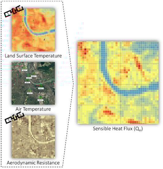
Figure 4.
Combined use of satellite observations with standard meteorological measurements for turbulent sensible heat flux estimation in the city of Basel, Switzerland based on the URBANFLUXES [35] approach. Maps were created with QGIS software, version 3.4.4 (www.qgis.org, accessed on 21 November 2019). Maps data: Google, GeoBasis-DE/BKG.
4. Discussion
4.1. Expected Impact
EO-based approaches are expected to develop further in the near future and generate novel analysis methods, including the estimation of energy, water, and carbon fluxes from satellite observations and alternative sources, enabling their integration into applications and operational services related to NBS implementation. Therefore, EO-based approaches are expected to advance the current knowledge of the impacts of the large-scale NBS implementation on urban climate, and, consequently, on energy consumption in cities. This will lead to the development of tools and strategies to mitigate these effects, improving thermal comfort and energy efficiency. Additionally, it will support the monitoring and reporting of activities needed towards the 2030 targets of the EU policy framework for climate and energy [60] and the 2050 climate-neutrality target of the EU long-term strategy [61], which are in alignment with the European Green Deal [62], the Paris Agreement [63], and the 2030 Agenda for Sustainable Development [1]. Furthermore, considering the fact that the New Urban Agenda calls for developing a more systematic approach to assess and address new and emerging risks, as well as to ensure that cities are implementing policies for sustainable and resilient UPD [64], EO-based monitoring and evaluation approaches are expected to have an important role towards this direction.
EO-based monitoring and evaluation approaches can be replicable in any city, since they are based mostly on satellite data. Open global data can effectively support the harmonization and standardization of the approaches, deployed in the framework of monitoring and evaluation stages. Moreover, the long-term operation of the Copernicus Sentinels series guarantees the future supply of satellite observations, providing the means for the development and realization of EO-based robust monitoring and evaluation systems, as well as supporting strategies focusing on urban environment and on the sustainable use of resources. Hence, tools developed to analyze these time series of data will be able to support sustainable and resilient UPD strategies, factoring in the spatiotemporal modification of UEB fluxes caused by large-scale NBS implementation. This type of exploitation regarding NBS is expected in the framework of the large demonstration initiatives.
4.2. Future Perspectives
This EO-based knowledge for urban areas will be capable of supporting several research and innovation activities under the forthcoming Horizon Europe EU framework programme [65]. Focusing on the targeted scientific areas of this programme, it can contribute to several Missions, incorporated largely into the thematic areas of “Climate-neutral and Smart Cities” and “Adaptation to Climate Change, including Societal Transformation”. In addition, several key societal research and innovation orientations can be supported through all Clusters, and mainly through Cluster 5 (climate, energy, and mobility), Cluster 6 (food, bioeconomy, natural resources, agriculture, and environment) and Cluster 4 (digital, industry, and space).
However, several identified barriers should be addressed towards achieving the potential of monitoring and evaluation regarding NBS. The barriers are relevant to: (a) the availability, combination, or comparison of different datasets; (b) the connection of NBS impacts among different spatial scales; (c) the quality (e.g., accuracy) of the available research means; (d) the replicability of these means for different NBS cases or aspects (e.g., social capacity); and (e) the needed resources for their deployment. These barriers prove that the process of NBS monitoring and evaluation is still not fully mature and needs further acceptance and validation. Moreover, there is still insufficient evidence about NBS effectiveness, quantified impacts and emerged connections (synergies, trade-offs, etc.) across various challenges (knowledge gaps). This deficit is mainly due to the absence of (adequate) monitoring and evaluation actions concerning the most of planned and implemented NBS [15]. Indeed, only a minority of NBS case studies has included monitoring and evaluation activities for examining the resulted ecosystems [66], and the potential of EO in support of our understanding about the role of NBS in energy, water, and carbon balance modification remains underexploited [67]. Although scientific knowledge exists on solutions for urban planning practices in a warming climate [68], there is currently neither product nor service that is readily available to address this gap.
Towards enhancing the operational implementation of a robust EO-based approach for NBS monitoring and evaluation in urban areas (including the estimation of energy, water and carbon fluxes), the following steps are necessary:
- Engaging international initiatives, hubs, and networks of EO community (e.g., Committee on Earth Observation Satellites—CEOS, Group on Earth Observations—GEO, etc.) in this context, and including the NBS field in their research activities.
- Defining advanced and replicable methodologies, guidelines, mechanisms, techniques, services, models, indicators, standards, etc.; forming an integrated and coherent EO-based framework.
- Applying the developed EO-based framework in selected areas to monitor and evaluate NBS implementation, proving the added value of NBS on important issues as to the quality of life, climate change adaptation and mitigation, and risk management and resilience.
- Evaluating EO-based results using in situ evidence of energy, water, and carbon fluxes changes (data resulted from flux towers, weather stations, etc.).
- Documenting the various aspects of NBS impacts, leading to an enhanced knowledge base [7], including continuous spatiotemporal information for urban areas.
- Disseminating knowledge to all local, national, and international targeted groups, including the public administration and market, and using monitoring and evaluation of NBS and their components in actual UPD practices.
- Supporting demonstration projects in the framework of the EU NBS initiative [15,54] with validated and documented monitoring and evaluation systems.
- Planning additional satellite missions for supporting the protection of coastal NBS shoreline, measuring variables related to urban climate, or for other objectives [35].
5. Conclusions
The field of EO is rather beneficial for the monitoring and evaluation of implemented NBS in urban areas, providing quality and tangible information, quantifying multiple environmental NBS impacts, covering urban areas of diverse scales, and enabling multitemporal NBS assessment. This paper makes specific reference to the potential use of EO to monitor the UEB, which is also a major advantage for the evaluation of NBS’ impact on the local climate of urban areas. Moreover, in several cases, deploying EO is quite cost-efficient and can produce NBS-related datasets that cover extended urban areas worldwide with a long-term commitment. All these EO aspects contribute to verifying NBS effectiveness compared to planning goals and/or alternative solutions, considering local conditions, informing local stakeholders through relevant tools, and eventually supporting NBS adaptive management. Furthermore, EO-based monitoring and evaluation constitute an important research and development direction regarding urban NBS uptake, since there are many emerging technological and scientific advancements that can provide new possibilities in respect of monitoring and evaluation research and innovation. Indeed, through adopting and realising the proposed steps regarding future perspectives, these advancements will be able to provide NBS monitoring data, which will significantly exceed the amount and quality of the present data and enrich NBS evaluation processes in the foreseeable future. Therefore, it is expected to further improve the understanding of the dynamics of urban systems, promoting the role of EO as a relevant and timely tool that supports policy-making by providing useful information. In this context, ongoing EO-based projects focusing on urban sustainability and resilience, such as CURE, may assist significantly.
Author Contributions
All authors contributed to different subject areas of the manuscript: N.C., G.S., and S.S. engaged with the NBS subject area; all authors engaged with the monitoring and evaluation subject area; N.C., S.S., Z.M., M.-S.W., and H.-C.H. engaged with the EO subject area. All authors have read and agreed to the published version of the manuscript.
Funding
The research was partially conducted in the framework of the project CURE (http://cure-copernicus.eu, accessed on 22 December 2020), that has received funding from the EU Horizon 2020 Research and Innovation Programme, under Grant Agreement No 870337. Also, M. S. Wong would like to thank the funding support from a grant by the General Research Fund, Hong Kong (Grant No 15602619).
Data Availability Statement
No new data were created or analyzed in this study. Data sharing is not applicable to this article.
Acknowledgments
Conflicts of Interest
The authors declare no conflict of interest.
References
- UN. Transforming our World: The 2030 Agenda for Sustainable Development (A/RES/70/1); UN: New York, NY, USA, 2015. [Google Scholar]
- Shove, E. Beyond the ABC: Climate change policy and theories of social change. Environ. Plan. A Econ. Space 2010, 42, 1273–1285. [Google Scholar] [CrossRef]
- Leichenko, R. Climate change and urban resilience. Curr. Opin. Environ. Sustain. 2011, 3, 164–168. [Google Scholar] [CrossRef]
- Faivre, N.; Fritz, M.; Freitas, T.; de Boissezon, B.; Vandewoestijne, S. Nature-based solutions in the EU: Innovating with nature to address social, economic and environmental challenges. Environ. Res. 2017, 159, 509–518. [Google Scholar] [CrossRef] [PubMed]
- Eggermont, H.; Balian, E.; Azevedo, J.M.N.; Beumer, V.; Brodin, T.; Claudet, J.; Fady, B.; Grube, M.; Keune, H.; Lamarque, P.; et al. Nature-based solutions: New influence for environmental management and research in Europe. GAIA Ecol. Perspect. Sci. Soc. 2015, 24, 243–248. [Google Scholar] [CrossRef]
- EC. Towards an EU Research and Innovation Policy Agenda for Nature-Based Solutions and Re-Naturing Cities—Final Report of the Horizon 2020 Expert Group on ‘Nature-Based Solutions and Re-Naturing Cities’; Publications Office of the EU: Luxembourg, 2015. [Google Scholar]
- Kabisch, N.; Frantzeskaki, N.; Pauleit, S.; Naumann, S.; Davis, M.; Artmann, M.; Haase, D.; Knapp, S.; Korn, H.; Stadler, J.; et al. Nature-based solutions to climate change mitigation and adaptation in urban areas: Perspectives on indicators, knowledge gaps, barriers, and opportunities for action. Ecol. Soc. 2016, 21, 39:1–39:15. [Google Scholar] [CrossRef]
- Scott, M.; Lennon, M.; Haase, D.; Kazmierczak, A.; Clabby, G.; Beatley, T. Nature-based solutions for the contemporary city/re-naturing the city/reflections on urban landscapes, ecosystems services and nature-based solutions in cities/multifunctional green infrastructure and climate change adaptation: Brownfield greening as an adaptation strategy for vulnerable communities?/delivering green infrastructure through planning: Insights from practice in Fingal, Ireland/planning for biophilic cities: From theory to practice. Plan. Theory Pract. 2016, 17, 267–300. [Google Scholar]
- Van den Bosch, M.; Ode Sang, Å. Urban natural environments as nature-based solutions for improved public health—A systematic review of reviews. Environ. Res. 2017, 158, 373–384. [Google Scholar] [CrossRef]
- Liquete, C.; Udias, A.; Conte, G.; Grizzetti, B.; Masi, F. Integrated valuation of a nature-based solution for water pollution control—Highlighting hidden benefits. Ecosyst. Serv. 2016, 22, 392–401. [Google Scholar] [CrossRef]
- Raymond, C.M.; Frantzeskaki, N.; Kabisch, N.; Berry, P.; Breil, M.; Nita, M.R.; Geneletti, D.; Calfapietra, C. A framework for assessing and implementing the co-benefits of nature-based solutions in urban areas. Environ. Sci. Policy 2017, 77, 15–24. [Google Scholar] [CrossRef]
- Augusto, B.; Roebeling, P.; Rafael, S.; Ferreira, J.; Ascenso, A.; Bodilis, C. Short and medium- to long-term impacts of nature-based solutions on urban heat. Sustain. Cities Soc. 2020, 57, 102122:1–102122:10. [Google Scholar] [CrossRef]
- Ruangpan, L.; Vojinovic, Z.; Di Sabatino, S.; Leo, L.S.; Capobianco, V.; Oen, A.M.P.; McClain, M.E.; Lopez-Gunn, E. Nature-based solutions for hydro-meteorological risk reduction: A state-of-the-art review of the research area. Nat. Hazards Earth Syst. Sci. 2020, 20, 243–270. [Google Scholar] [CrossRef]
- Seddon, N.; Chausson, A.; Berry, P.; Girardin, C.A.J.; Smith, A.; Turner, B. Understanding the value and limits of nature-based solutions to climate change and other global challenges. Phil. Trans. R. Soc. B 2020, 375, 20190120:1–20190120:12. [Google Scholar] [CrossRef] [PubMed]
- Somarakis, G.; Stagakis, S.; Chrysoulakis, N. (Eds.) ThinkNature Nature-Based Solutions Handbook; ThinkNature Horizon 2020 Project; European Union: Brussels, Belgium, 2019. [Google Scholar]
- Brink, E.; Wamsler, C.; Adolfsson, M.; Axelsson, M.; Beery, T.; Björn, H.; Bramryd, T.; Ekelund, N.; Jephson, T.; Narvelo, W.; et al. On the road to ‘research municipalities’: Analysing transdisciplinarity in municipal ecosystem services and adaptation planning. Sustain. Sci. 2017, 13, 765–784. [Google Scholar] [CrossRef] [PubMed]
- Frantzeskaki, N.; McPhearson, T.; Collier, M.J.; Kendal, D.; Bulkeley, H.; Dumitru, A.; Walsh, C.; Noble, K.; van Wyk, E.; Ordóñez, C.; et al. Nature-Based Solutions for Urban Climate Change Adaptation: Linking Science, Policy, and Practice Communities for Evidence-Based Decision-Making. BioScience 2019, 69, 455–466. [Google Scholar] [CrossRef]
- Xiang, P.; Yang, Y.; Li, Z. Theoretical Framework of Inclusive Urban Regeneration Combining Nature-Based Solutions with Society-Based Solutions. J. Urban. Plan. Dev. 2020, 146, 04020009:1–04020009:11. [Google Scholar] [CrossRef]
- Ahern, J. From fail-safe to safe-to-fail: Sustainability and resilience in the new urban world. Landsc. Urban. Plan. 2011, 100, 341–343. [Google Scholar] [CrossRef]
- Calliari, E.; Staccione, A.; Mysiak, J. An assessment framework for climate-proof nature-based solutions. Sci. Total Environ. 2019, 656, 691–700. [Google Scholar] [CrossRef]
- Gersonius, B.; Nasruddin, F.; Ashley, R.; Jeuken, A.; Pathirana, A.; Zevenbergen, C. Developing the evidence base for mainstreaming adaptation of stormwater systems to climate change. Water Res. 2012, 46, 6824–6835. [Google Scholar] [CrossRef]
- Kumar, P.; Debele, S.E.; Sahani, J.; Rawat, N.; Marti-Cardona, B.; Alfieri, S.M.; Basu, B.; Basu, A.S.; Bowyer, P.; Charizopoulos, N.; et al. An overview of monitoring methods for assessing the performance of nature-based solutions against natural hazards. Earth Sci. Rev. 2021, 217, 103603:1–103603:26. [Google Scholar] [CrossRef]
- Goldbach, A.; Kuttler, W. Quantification of turbulent heat fluxes for adaptation strategies within urban planning. Int. J. Climatol. 2013, 33, 143–159. [Google Scholar] [CrossRef]
- Chrysoulakis, N.; Castro, E.A.; Moors, E.J. (Eds.) Understanding Urban Metabolism: A Tool for Urban Planning; Routledge: New York, NY, USA, 2014. [Google Scholar]
- Stagakis, S.; Burud, I.; Thiis, T.; Gaitani, N.; Panagiotakis, E.; Lantzanakis, G.; Spyridakis, N.; Chrysoulakis, N. Spatiotemporal monitoring of surface temperature in an urban area using UAV imaging and tower-mounted radiometer measurements. In Proceedings of the 2019 Joint Urban Remote Sensing Event (JURSE), Vannes, France, 22–24 May 2019; pp. 1–4. [Google Scholar]
- Stagakis, S.; Chrysoulakis, N.; Spyridakis, N.; Feigenwinter, C.; Vogt, R. Eddy covariance measurements and source partitioning of CO2 emissions in an urban environment: Application for Heraklion, Greece. Atmos. Environ. 2019, 201, 278–292. [Google Scholar] [CrossRef]
- Poursanidis, D.; Chrysoulakis, N.; Mitraka, Z. Landsat 8 vs. Landsat 5: A comparison based on urban and peri-urban land cover mapping. Int. J. Appl. Earth Obs. Geoinf. 2015, 35, 259–269. [Google Scholar] [CrossRef]
- Hodul, M.; Knudby, A.; Ho, H.C. Estimation of continuous urban sky view factor from Landsat data using shadow detection. Remote Sens. 2016, 8, 568. [Google Scholar] [CrossRef]
- Wong, M.S.; Nichol, J.E. Spatial variability of frontal area index and its relationship with urban heat island intensity. Int. J. Remote Sens. 2013, 34, 885–896. [Google Scholar] [CrossRef]
- Chrysoulakis, N.; Mitraka, Z.; Stathopoulou, M.; Cartalis, C. A comparative analysis of the urban web of the greater Athens agglomeration for the last 20 years period on the basis of Landsat imagery. Fresenius Environ. Bull. 2013, 22, 2139–2144. [Google Scholar]
- Mackey, C.W.; Lee, X.; Smith, R.B. Remotely sensing the cooling effects of city scale efforts to reduce urban heat island. Build. Environ. 2012, 49, 348–358. [Google Scholar] [CrossRef]
- Tzelidi, D.; Stagakis, S.; Mitraka, Z.; Chrysoulakis, N. Detailed urban surface characterization using spectra from enhanced spatial resolution Sentinel-2 imagery and a hierarchical multiple endmember spectral mixture analysis approach. J. Appl. Remote Sens. 2019, 13, 016514:1–016514:17. [Google Scholar] [CrossRef]
- Panagiotakis, E.; Chrysoulakis, N.; Charalampopoulou, V.; Poursanidis, D. Validation of Pleiades tri-stereo DSM in urban areas. ISPRS Int. J. Geo-Inf. 2018, 7, 118. [Google Scholar] [CrossRef]
- Marconcini, M.; Metz, A. A suite of novel EO-based products in support of urban green planning. In Proceedings of the 21st International Conference on Urban Planning and Regional Development in the Information Society, Hamburg, Germany, 22–24 June 2016. [Google Scholar]
- Chrysoulakis, N.; Grimmond, S.; Feigenwinter, C.; Lindberg, F.; Gastellu-Etchegorry, J.-P.; Marconcini, M.; Mitraka, Z.; Stagakis, S.; Crawford, B.; Olofson, F.; et al. Urban energy exchanges monitoring from space. Sci. Rep. 2018, 8, 11498:1–11498:8. [Google Scholar] [CrossRef]
- Chrysoulakis, N.; Feigenwinter, C.; Triantakonstantis, D.; Penyevskiy, I.; Tal, A.; Parlow, E.; Fleishman, G.; Düzgün, S.; Esch, T.; Marconcini, M. A conceptual list of indicators for urban planning and management based on earth observation. ISPRS Int. J. Geo-Inf. 2014, 3, 980–1002. [Google Scholar] [CrossRef]
- Triantakonstantis, D.; Chrysoulakis, N.; Sazonova, A.; Esch, T.; Feigenwinter, C.; Düzgün, S.; Parlow, E.; Marconcini, M.; Tal, A. On-line evaluation of earth observation derived indicators for urban planning and management. Urban. Plan. Des. Res. 2015, 3, 17–33. [Google Scholar] [CrossRef]
- Berger, M.; Moreno, J.; Johannessen, J.A.; Levelt, P.F.; Hanssen, R.F. ESA’s sentinel missions in support of earth system science. Remote Sens. Environ. 2012, 120, 84–90. [Google Scholar] [CrossRef]
- Chrysoulakis, N.; Marconcini, M.; Sazanova, A.; Tal, A.; Düzgün, S.; Parlow, E.; Charalampopoulou, B.; Mitraka, Z.; Esch, T.; Cavur, M.; et al. Copernicus sentinels for urban planning in Russia: The SEN4RUS project. In Proceedings of the 4th International Conference on Countermeasures to Urban Heat Island, Singapore, 30 May–1 June 2016. [Google Scholar]
- Parastatidis, D. Urban Nature Based Solutions Application. Available online: https://ec.europa.eu/jrc/communities/sites/jrccties/files/eovalue_urban_nbs_presentation.pptx (accessed on 22 December 2020).
- Beloconi, A.; Kamarianakis, Y.; Chrysoulakis, N. Estimating urban PM10 and PM2.5 concentrations, based on synergistic MERIS/AATSR aerosol observations, land cover and morphology data. Remote Sens. Environ. 2016, 172, 148–164. [Google Scholar] [CrossRef]
- Ho, H.C.; Knudby, A.; Sirovyak, P.; Xu, Y.; Hodul, M.; Henderson, S.B. Mapping maximum urban air temperature on hot summer days. Remote Sens. Environ. 2014, 154, 38–45. [Google Scholar] [CrossRef]
- Ho, H.C.; Knudby, A.; Xu, Y.; Hodul, M.; Aminipouri, M. A comparison of urban heat islands mapped using skin temperature, air temperature, and apparent temperature (Humidex), for the greater Vancouver area. Sci. Total Environ. 2016, 544, 929–938. [Google Scholar] [CrossRef] [PubMed]
- Lai, P.-C.; Choi, C.C.Y.; Wong, P.P.Y.; Thach, T.-Q.; Wong, M.S.; Cheng, W.; Krämer, A.; Wong, C.-M. Spatial analytical methods for deriving a historical map of physiological equivalent temperature of Hong Kong. Build. Environ. 2016, 99, 22–28. [Google Scholar] [CrossRef]
- Wong, M.S.; Zhu, R.; Liu, Z.; Lu, L.; Peng, J.; Tang, Z.; Lo, C.H.; Chan, W.K. Estimation of Hong Kong’s solar energy potential using GIS and remote sensing technologies. Renew. Energy 2016, 99, 325–335. [Google Scholar] [CrossRef]
- Feigenwinter, C.; Parlow, E.; Vogt, R.; Schmutz, M.; Chrysoulakis, N.; Lindberg, F.; Marconcini, M.; del Frate, F. Spatial distribution of sensible and latent heat flux in the city of Basel (Switzerland). IEEE J. Sel. Top. Appl. Earth Obs. Remote Sens. 2018, 11, 2717–2723. [Google Scholar] [CrossRef]
- Liu, H.Y.; Kobernus, M.; Broday, D.; Bartonova, A. A conceptual approach to a citizens’ observatory—Supporting community-based environmental governance. Environ. Health 2014, 13, 107:1–107:13. [Google Scholar] [CrossRef]
- Parastatidis, D.; Mitraka, Z.; Chrysoulakis, N.; Abrams, M. Online global land surface temperature estimation from Landsat. Remote Sens. 2017, 9, 1208. [Google Scholar] [CrossRef]
- Bai, Y.; Wong, M.S.; Shi, W.Z.; Wu, L.X.; Qin, K. Advancing of land surface temperature retrieval using extreme learning machine and spatio-temporal adaptive data fusion algorithm. Remote Sens. 2015, 7, 4424–4441. [Google Scholar] [CrossRef]
- Esch, T.; Taubenböck, H.; Roth, A.; Heldens, W.; Felbier, A.; Thiel, M.; Schmidt, M.; Müller, A.; Dech, S. Tandem-x mission—New perspectives for the inventory and monitoring of global settlement patterns. J. Appl. Remote Sens. 2012, 6, 061702:1–061702:22. [Google Scholar] [CrossRef]
- Mitraka, Z.; Chrysoulakis, N.; Kamarianakis, Y.; Partsinevelos, P.; Tsouchlaraki, A. Improving the estimation of urban surface emissivity based on sub-pixel classification of high resolution satellite imagery. Remote Sens. Environ. 2012, 117, 125–134. [Google Scholar] [CrossRef]
- Mitraka, Z.; Chrysoulakis, N.; Doxani, G.; del Frate, F.; Berger, M. Urban surface temperature time series estimation at the local scale by spatial-spectral unmixing of satellite observations. Remote Sens. 2015, 7, 4139–4156. [Google Scholar] [CrossRef]
- Sun, T.; Grimmond, S. A pythonenhanced urban land surface model SuPy (SUEWS in Python, v2019.2): Development, deployment and demonstration. Geosci. Model. Dev. 2019, 12, 2781–2795. [Google Scholar] [CrossRef]
- CORDIS—EU Research Results. Available online: https://cordis.europa.eu/projects/en (accessed on 22 December 2020).
- Chrysoulakis, N.; Mitraka, Z.; Marconcini, M.; Ludlow, D.; Khan, Z.; Holt Andersen, B.; Soukup, T.; Dohr, M.; Gandini, A.; Kropp, J.; et al. Copernicus for urban resilience in Europe: The CURE project. In Proceedings of the 22nd EGU General Assembly, Online, 4–8 May 2020. [Google Scholar]
- Ramamurthy, P.; Bou-Zeid, E.; Smith, J.A.; Wang, Z.; Baeck, M.L.; Saliendra, N.Z.; Hom, J.L.; Welty, C. Influence of subfacet heterogeneity and material properties on the urban surface energy budget. J. Appl. Meteorol. Climatol. 2014, 53, 2114–2129. [Google Scholar] [CrossRef]
- Nordbo, A.; Järvi, L.; Haapanala, S.; Moilanen, J.; Vesala, T. Intra-city variation in urban morphology and turbulence structure in Helsinki, Finland. Bound. Layer Meteorol. 2013, 146, 469–496. [Google Scholar] [CrossRef]
- Wong, M.S.; Yang, J.; Nichol, J.; Weng, Q.; Menenti, M.; Chan, P. Modeling of anthropogenic heat flux using HJ-1B Chinese small satellite image: A study of heterogeneous urbanized areas in Hong Kong. IEEE Geosci. Remote Sens. Lett. 2015, 12, 1466–1470. [Google Scholar] [CrossRef]
- Kuang, W.; Dou, Y.; Zhang, C.; Chi, W.; Liu, A.; Liu, Y.; Zhang, R.; Liu, J. Quantifying the heat flux regulation of metropolitan land use/land cover components by coupling remote sensing modeling with in situ measurement. J. Geophys. Res. Atmos. 2015, 120, 113–130. [Google Scholar] [CrossRef]
- EC. A Policy Framework for Climate and Energy in the Period from 2020 to 2030 (COM/2014/015 Final); EC: Brussels, Belgium, 2014. [Google Scholar]
- EC. A Clean Planet for All—A European Strategic Long-Term Vision for a Prosperous, Modern, Competitive and Climate Neutral Economy (COM/2018/773 Final); EC: Brussels, Belgium, 2018. [Google Scholar]
- EC. The European Green Deal (COM/2019/640 Final); EC: Brussels, Belgium, 2019. [Google Scholar]
- UN. Paris Agreement; UN: New York, NY, USA, 2015. [Google Scholar]
- UN. New Urban Agenda (A/RES/71/256); UN: New York, NY, USA, 2017. [Google Scholar]
- EC. Orientations towards the First Strategic Plan for Horizon Europe; EC: Brussels, Belgium, 2019. [Google Scholar]
- Nikolaidis, N. Think nature-based solutions. Proj. Repos. J. 2019, 3, 56–59. [Google Scholar]
- Chrysoulakis, N.; Mitraka, Z. Copernicus Sentinels observations as a tool to evaluate NBS implementation. In Proceedings of the European Conferences on Biodiversity and Climate Change (ECBCC 2015), Bonn, Germany, 17–19 November 2015. [Google Scholar]
- Aminipouri, M.; Knudby, A.; Ho, H.C. Using multiple disparate data sources to map heat vulnerability: Vancouver case study. Can. Geogr. Géogr. Can. 2016, 60, 356–368. [Google Scholar] [CrossRef]


Publisher’s Note: MDPI stays neutral with regard to jurisdictional claims in published maps and institutional affiliations. |
© 2021 by the authors. Licensee MDPI, Basel, Switzerland. This article is an open access article distributed under the terms and conditions of the Creative Commons Attribution (CC BY) license (https://creativecommons.org/licenses/by/4.0/).