Abstract
A total of 3047 individual shallow cumuli were identified from 9 years of polarization lidar measurements (2011–2019) at Wuhan, China (30.5°N, 114.4°E). These fair-weather shallow cumuli occurred at the top edge of the convective boundary layer between April and October with the maximum occurrence in July over the 30°N plain site. They persisted mostly (>92%) for a short period of ~1–10 min and had a geometrical thickness of ~50–600 m (a mean of 209 ± 138 m). The majority (>94%) of the cloud bases of these cumuli were found to appear ~50–560 m (a mean of 308 ± 254 m) above the lifting condensation level (LCL). In this height range from the LCL to the cloud base, the lidar volume depolarization ratio () slightly decreased with increasing height, showing gradually increasing condensation in this sub-cloud region due to penetrative thermals. Most of the observed shallow cumuli (79%) formed under the conditions of high near-surface air temperature (>30 °C) and water vapor mixing ratio (>15 g kg−1).
1. Introduction
The atmospheric boundary layer (ABL) is the lowest part of the troposphere that is directly influenced by the earth’s surface. It can respond to surface forcing within hours or less [1,2,3]. In the daytime, the earth’s surface is heated by solar radiation to produce rising warm air plumes so that the ABL is controlled by thermal convection and is designated a “convective boundary layer (CBL)” or “mixing layer (ML)” [1]. Clouds play a pivotal role in the weather, climate, and regional/global hydrological cycle on Earth [4,5,6]. The Earth’s radiation budget largely depends on the cloud coverage, height, thickness, and composition [7,8,9]. The hydrological cycle can be driven by the radiation balance and, in turn, determines where clouds form [10,11,12]. This coupling of clouds, water circulation, and radiation budget composes the feedback process, and clouds, especially low clouds, are the main uncertainty in the system [13]. Under fair-weather conditions, convective clouds or shallow cumuli would form on the top of the plumes when moisture is sufficient [14]. The shallow cumuli are likely to have cloud bases at the lifting condensation levels (LCL) or above [15]. Although shallow cumuli have coverage of only ~5% over land and ~12% over ocean [16,17], they can significantly influence the solar radiation to the earth’s surface [18], modify the structure of the CBL by affecting turbulent mixing [19], and play a significant role in the initiation of ice or precipitation [20,21].
Various measurements with ground-based lidar/radar and airborne and spaceborne sensors have revealed the cloud morphology and statistical properties of shallow cumuli. They can exist for several minutes with a typical horizontal scale of ~1 km or less [14,22,23]. Their geometrical thickness is mostly less than 1 km [24]. The cloud top/base heights and their spatial/temporal distributions for shallow cumuli over the tropical belt and the Tibet Plateau have been characterized based on the spaceborne lidar measurements (the cloud-aerosol lidar and infrared pathfinder satellite observation, CALIPSO). Most shallow cumuli over the tropical ocean have cloud tops below 3 km, whereas those over tropical land tend to have higher cloud tops which are more strongly affected by diurnal variation in convection [25]. Cumulus clouds represent one of the dominant cloud types over the Tibet Plateau in the northern summer. The corresponding occurrence rate is much higher than that in the Tibet Plateau’s surrounding regions [26]. Rodts et al. [27], using aircraft in situ measurements, found that the mass flux and buoyancy flux were dominated by intermediate-sized clouds (horizontal dimension of about 1 km) while the cloud fraction was by the smallest clouds (horizontal dimension less than 1 km), stating that the large-sized clouds contribute more to the dynamical properties, and the small-sized clouds largely outnumber the large-sized clouds. Based on the three-day observations of updraft and downdraft in the convective boundary layer with a ground-based Doppler lidar on a 51.4°N flat terrain, the relationship between the draft occurrence frequency and the shallow cumulus formation has been examined [28]. In the case of cumulus formation, the draft is enhanced by ~50% in frequency near the cloud base.
The atmospheric radiation measurement (ARM) climate research facility southern Great Plains (SGP) sites are located in north-central Oklahoma and south Kansas (36.5°N), a flat area that is sparsely populated. Combined observations with remote and in situ sensors at the ARM SGP sites have yielded a comprehensive look into the characteristics of continental shallow cumulus clouds and corresponding CBL atmospheric conditions [14,23,29,30,31]. The cloud properties show a clear-cut diurnal cycle [29]. The cloud fraction has a maximum value at around 14:00 local time (LT), which is sensitive to both the low-level moisture and the surface sensible heat flux. The average cloud-base height rises throughout the day, while the average cloud thickness falls with time. It is shown that the vertical velocity has increased variance during periods of medium cloud cover and larger skewness on shallow cumulus days than on clear-sky days [14]. The clouds with a positive cloud-based mass flux account for 63% of clouds and are linked to coherent updrafts extending over the entire CBL. In contrast, negative mass flux clouds lack coherent subcloud (the region below cloud base) drafts. Although many works have been reported, there is still a lack of research based on process-level observation that can present the detailed characterization of variation and structure of the cumulus.
The shallow cumuli remain, however, incompletely represented in general circulation models (GCMs) because of their small time (~10 min or less) and space (~1 km) scales, as well as behavior differences under different weather systems [14,32]. As a result, the GCMs suffer from errors in the location, timing, and extent of shallow clouds [33], which then affects the other components of the simulated system such as the structure of the ABL [34]. Moreover, the lifting mechanism varies on the distinct underlying surfaces (continent or ocean, mountain or plain, urban or rural area, forested or deforested surface) [30,35,36,37,38]. To deepen our understanding relevant to the formation of the CBL cumuli, and enhance the performance of the GCMs, long-term, routine, and process-level lidar observations at more sites with different latitudes and underlying surfaces are required.
This work presents the long-term CBL cumulus observations using a ground-based polarization lidar. The polarization lidar has been operated routinely under fair weather conditions since October 2010 at Wuhan University atmospheric observatory, Wuhan, China (30.5°N, 114.4°E) [39]. The shallow cumuli were observed on 117 out of 848 observational days during 2011–2019. Each cumulus cloud day contains at least 6-hour lidar profiles in the period from 09:00 to 18:00 LT. Such abundant lidar data, together with simultaneously collected surface weather parameters, allow us to systematically investigate the continental cumulus cloud formation and relevant CBL atmospheric conditions over a megacity located on a mid-latitude plain. Here, this paper starts with instruments and methodology in Section 2. Then, Section 3 presents two examples and statistics on the observed shallow cumuli. The discussion and conclusions are finally given in Section 4 and Section 5.
2. Instruments and Methodology
Cloud observations were made by a 532 nm polarization lidar deployed at Wuhan University atmospheric observatory. The observatory site (70 m above sea level) is located on a vegetation-covered small hill with a maximum peak height of 118 m which lies in the heart of the city of Wuhan. Wuhan is an industrialized megacity in central China. It is situated on the eastern Jianghan Plain, which has an area of ~46,000 km2 and a mean elevation of only 27 m above sea level. Wuhan has a humid subtropical climate with abundant rainfall and four distinctive seasons.
2.1. Instruments
2.1.1. Polarization Lidar
During the period from October 2010 to the end of 2019, all of the polarization lidar observation sessions started under fair weather conditions and were terminated before extensive cloud cover or precipitation. The system parameters of our polarization lidar and its performance have been described in detail by Kong and Yi [39]. Here, we brief the technical improvement about its polarization measurement. A Brewster polarizer is used to increase the polarization purity of the output laser beam (up to 10,000:1). In the receiver optics, two additional polarizers are placed, respectively, on the two output sides of the polarization beam splitter prism (PBS) to reduce the crosstalk (probably occurring during cloud observation) between the two orthogonal polarization channels. The raw lidar data were stored with a vertical resolution of 3.75 m and a temporal resolution of 1 min. The lowest measurement height was 0.3 km due to an overlap factor effect caused by the off-axis lidar design.
The backscatter ratio (BSR) is defined as the ratio of the total (particulate and molecular) backscatter coefficient divided by the molecular one. It generally reflects the content of aerosols or clouds. For the standard lidar equation, two unknown variables (backscatter coefficient and extinction coefficient) are included in one equation. We need to make the following assumptions [40]: the molecular lidar ratio (molecular extinction coefficient divided by molecular backscatter coefficient) can be calculated from Rayleigh scattering theory, the lidar ratio (aerosol extinction coefficient divided by aerosol backscatter coefficient) is chosen according to the type of dominated aerosol, and the backscatter ratio BSR is known at a certain height. Once the assumptions are confirmed, there are two options to solve the lidar equation. The first is choosing the reference height without aerosols at a high altitude, assuming the BSR value, and making the backward integration (from the reference height to the surface). The result of this option is stable and this is the common choice for aerosol study. The other option is choosing the reference height at a low altitude, confirming the BSR value, and making the forward integration (from the low to the high altitude). The forward integration is unstable and may encounter the failure of retrieval.
Normally, for optically thin layers, the backscatter ratio BSR can be retrieved from the Mie signal (backscatter signal from aerosols or clouds) profile of lidar by assuming a constant lidar ratio and choosing an aerosol-free reference altitude. In the case of cloud, it is always difficult to find a reference altitude above the cloud base due to strong attenuation. In this study, the backward retrieval scheme with a lidar ratio of 50 sr and a reference altitude of ~7 km was utilized for the cloud-free profiles [41], while the forward retrieval scheme with a lidar ratio of 18.6 sr and a reference altitude of ~0.3 km was used for the cloud profiles [42]. The error of R comes from the noise of the signal, lidar ratio, and BSR at the reference height. In this study, the backward retrieval uncertainty of R is estimated as 15–20% (corresponding to the uncertainty of 10% and 4% for lidar ratio and BSR at the reference height, respectively) based on the error analysis by Comerón et al. [43]. As for the forward retrieval, the uncertainty of BSR at the reference height is larger due to the variation of aerosols at the low altitude. If we assume the uncertainty of the lidar ratio and BSR at the reference height is 10% and 50%, respectively, the uncertainty of BSR is estimated to be 45–55%.
Besides, the CBL height was calculated by using the variance method [39,44] based on 30 min cloud-free BSR profiles (if available). The foundation of the variance method is taking the aerosols as the tracer of the convective evolution of the boundary layer. The maximum in the vertical profile of the variance of BSR is taken as the CBL height. The height values in this article are all relative to sea level.
The volume depolarization ratio is defined as the ratio of the perpendicular- to parallel-polarized backscatter coefficients. It can be calculated from the lidar signals of the two channels with the channel relative gain calibrated in advance using a method presented by Freudenthaler et al. [45]. The could be used to investigate the particle shapes of clouds and aerosols [46], enabling us to obtain the sub-cloud liquid droplet layer properties due to condensation or hygroscopic growth [47].
2.1.2. Surface Weather Station
A surface weather station (CR800, made by Campbell Scientific, Inc., Logan, UT, USA) was installed near our 532 nm polarization lidar from March 2010. This allowed us to obtain the surface temperature, relative humidity, horizontal wind speed, and direction in 1 min time resolution, showing the surface meteorological parameters during the presence of shallow cumuli. Due to instrument breakdown, the data for the periods of August 2014, February–August 2015, and February–May 2016 are not available.
2.1.3. Cloud Camera
A fisheye lens camera was placed beside the lidar for taking all-sky images over our site from August 2018. The fisheye camera has a field-of-view (FOV) of °. The all-sky images were captured every 2 min and stored automatically. The all-sky images were used to confirm that the formation or dissipation process of the cumulus occurred in the field-of-view of our lidar. In this study, we only utilized the lidar data with the simultaneous all-sky images from August 2018 to December 2019 to present the case studies.
2.2. Methodology
2.2.1. Cloud Information and Event Identification
In terms of the range-squared-corrected lidar signal (X) profile, the shallow cumulus clouds are characterized by large signal enhancement in a narrow height range (~300 m or less) at the top of the convective boundary layer (see Figure 1). The cloud base can be defined as a height above which the signal enhancement starts immediately. In the narrow height range, the cloud peak was determined as a height where the range-corrected lidar signal maximizes. The cloud base, peak, and top height were calculated using the method introduced by Platt et al. [48]. In detail, the cloud base was determined as the level at which the signal continued to increase for at least 5 height intervals. The cloud top (or effective top) was calculated as the level at which the signal continued to decrease for 5 height intervals. If the continuous decrease search failed, the height at which the signal drops to the background level was defined as the effective top. Then, the cloud peak height was the level at which the signal maximized. Following the criterion of the peak-to-base signal ratio for distinguishing cloud from aerosol layers [49], the signal profile was registered as a cumulus cloud profile when the ratio value was larger than 4.0. For identifying individual cumulus cloud events, we consecutively surveyed all the 117-day sequences of the 1-min lidar signal profiles according to the criterion of peak-to-base ratio value of 4.0. Figure 1 presents a typical cumulus lidar profile and the cloud information determined by the abovementioned method. The lifting condensation level (LCL), cloud base height, cloud peak height, and cloud top height are shown, respectively, by the black long dash, red long dash, red dash-dotted, and red short dash lines.
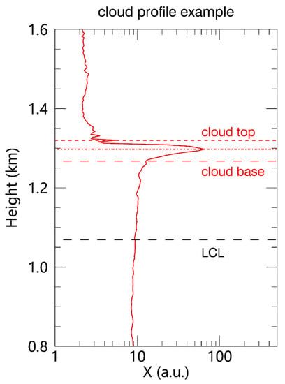
Figure 1.
A plot of 1 min polarization lidar range-squared-corrected signal X profile observed at 1125 LT on 9 August 2019. The lifting condensation level (LCL), cloud base height, cloud peak height, and cloud top height are shown, respectively, by the black long dash, red long dash, red dash-dotted, and red short dash lines. The LCL is calculated based on Equation (1) in Section 2.2.2.
A cumulus cloud event was defined as follows. For sequences of the 1 min range-squared-corrected lidar signal profiles, the event started with a cloud-free profile and ended with a cloud profile. The interval between the two events must be larger than 3 min (3 cloud-free profiles). A cumulus case day must contain at least 10 events. For a short-duration cumulus cloud event for which the lidar signal enhancement was visible in only one single profile, its parameters (cloud base/peak/top) were obtained simply from the 1 min profile. For a long-duration cumulus cloud event where the signal enhancement was discernible in several consecutive profiles (occurring in nearly the same height range), its parameters were from the average of the consecutive profiles.
2.2.2. Lifting Condensation Level
The lifting condensation level (LCL) is the height at which water vapor in an air parcel becomes saturated if the parcel is lifted adiabatically. It simplifies some actual physics processes (heat exchange, condensation) happening in the upward air parcel and can be used as a reasonable estimate of cloud base height when parcels experience forced ascent [50]. We present the CBL height evolution and LCL variation during the daytime to discuss the formation mechanism of cumulus in case studies. Besides, we compare the observed cloud base height with the calculated LCL and infer what causes the difference. The LCL ZLCL was computed from the surface temperature (T) and relative humidity (RH) using the approximation [51]:
3. Results
The polarization lidar started routine operation under fair weather in October 2010, and a total of ~20,000 hours of lidar data were collected till the 31st of December, 2019. Using the abovementioned method, 117 days with CBL cumulus occurrence are determined out of 848 observation days between the 1st of January, 2011 and the 31st of December, 2019. Benefitting from the 1 min time and 3.75 m range resolution of our lidar, the processes of cumulus formation, evolution, and dissipation could be captured. In this section, we start with two representative cases, followed by a series of statistics of the CBL cumulus from 117 case days.
3.1. Case on 9 August 2019
Figure 2 shows the time–height contour plots (1 min/3.75 m resolution) of the X and on the 9th of August, 2019. The X contour (Figure 2a) illustrates a typical daytime CBL evolution (CBL height marked by filled black circles): rapidly growing CBL height from 09:00 to 11:30 LT, slower CBL height growth (mixed with the cumulus then the CBL heights are determined by cloud base height [52]) from 12:00 to 15:00 LT, and decreasing CBL height from 15:30 to 17:30 LT. The CBL height started growing at 09:00 LT (observed by our lidar) from ~0.43 km and reached 1.1 km at 11:30 LT. Meanwhile, the LCL was always above the CBL height, maintaining a state which was unsuited to the formation of cumuli. The surface T and water vapor mixing ratio (WVMR) generally kept growing, as seen from Figure 2c. However, after a rapid-rise phase, the CBL height jumped over and maintained above the LCL from 11:30 to 15:30 LT. During this period, it could be expected that the increasing surface moisture was transported upward (a decrease of surface WVMR could be found at ~11:00 LT from Figure 2c) by convective lifting (surface T above 35 °C), filling the growing CBL. As air parcels with sufficient moisture were lifted across the LCL level, they could become oversaturated, which led to the formation of a series of clouds in a height range of 1.2–2.0 km. A total of 19 intermittent cumulus events were observed during this period, with each lasting less than 15 min. From Figure 2b, the region under the cumulus base presented relatively low values during 13:00–16:00 LT, suggesting the existence of water droplets. The CBL height began decreasing rapidly from 15:00 LT, and was lower than the LCL after 15:30 LT; the accompanying surface T started a sharp decrease, indicating that the net radiation to the surface became negative starting from this period, and the thermal convection would weaken. The surface WVMR presented a sudden decrease starting from 15:25 LT, a short delay in contrast to the decrease in surface T. No other cumulus events were observed after 15:00 LT.
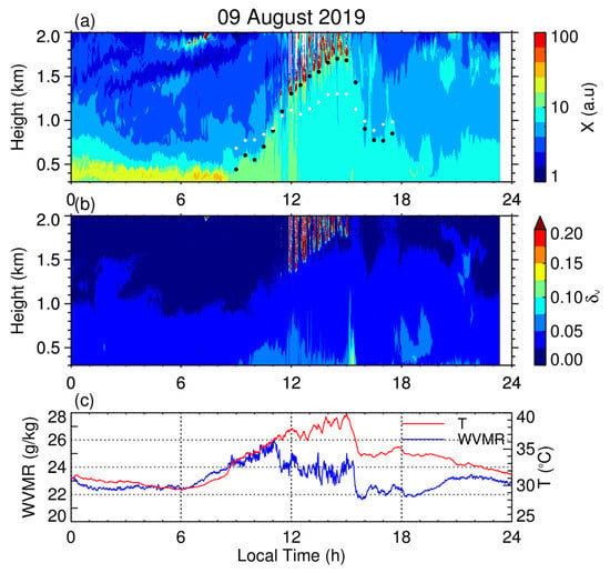
Figure 2.
Time–height contour plots (1 min/3.75 m resolution) of (a) range-squared-corrected signal X; (b) volume depolarization ratio measured by Wuhan University 532 nm polarization lidar on the 9th of August, 2019; and (c) diurnal variation of the surface temperature (T) and WVMR, recorded by a co-located surface weather station, which exhibit an example of a shallow cumulus day. The CBL height in Figure 2a (filled black cycles) is determined by the variance method (calculated on a 30 min basis) and lifting condensation level (LCL) is indicated by white diamonds. Note that the shallow cumuli occurred when both the near-surface air temperature and water vapor mixing ratio were high in the afternoon.
To demonstrate the short time evolution of the cumulus cloud, a representative event was chosen and the corresponding sequences of the 1 min backscatter ratio BSR and profiles during 11:24–11:29 LT on the 9th of August, 2019 are plotted in Figure 3a. The quasi-simultaneous all-sky images (captured every 2 min) are also shown in Figure 3b to confirm that the cumulus forms/dissipates in the lidar field-of-view (FOV). As seen from Figure 3a, no liquid water layer or cloud was observed above the LCL (~1.07 km) at 11:24 LT. One minute later, the initial stage of cumulus was observed, with a cloud base height of ~1.27 km. The cumulus cloud peak was located at ~1.3 km with a peak BSR of ~84 and a corresponding of ~0.019. A height interval of ~0.2 km for the sub-cloud zone (defined as the zone between the cloud base and LCL) suggests that strong updrafts from the air mass precipitate the phase transition from water vapor to liquid. The profiles at 11:26 and 11:27 LT showed a steady cloud base (~1.26 km and ~1.25 km, respectively) and denser, broader cloud body (respective peak BSR of ~135 and ~504, more condensed liquid water) contrasting to the 11:24 LT profile. Then, at 11:28 LT, the peak BSR was ~92 and the corresponding ~0.018; the cumulus structure became similar to the initial stage, probably due to the high environmental temperature and lack of lifted water supply, then, that part of the condensed water evaporated. Up to 11:29 LT, the cumulus dissipated completely. The cloud thickness did not exceed 150 m for all of the four cumulus profiles. Note that the profile values of BSR in the sub-cloud zone showed an increment with height, while the corresponding exhibited a slow decrement throughout the event. This suggests that the sub-cloud region is rich in aerosols lifted by convection and the water droplets, which form via the lifting condensation or convective condensation, supplying moisture for the cloud above.
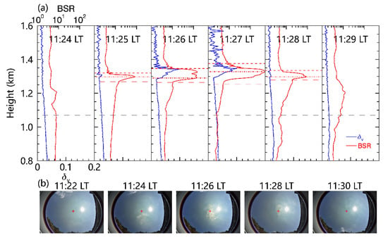
Figure 3.
(a) Profiles of lidar backscatter ratio (R, red) and volume depolarization ratio (, blue) during 11:24–11:29 LT on the 9th of August, 2019, which display an example of individual shallow cumuli evolving from formation to disappearance. The lifting condensation level (LCL), cloud base height, cloud peak height, and cloud top height are shown, respectively, by black long dash, red long dash, red dash-dotted, and red short dash lines. (b) Photographs of the sky recorded by a ground-based camera at our lidar site, which display the evolving appearance of this shallow cumulus. The center of the plus symbol shows the region which is in the field-of-view of the lidar.
3.2. Case on 31 July 2019
Figure 4 provides another case of a CBL cumulus observed on the 31st of July, 2019. As seen from Figure 4a, the CBL height started growing at 08:00 LT from ~0.38 km along with growing surface WVMR, and reached 1.09 km at 11:30 LT. Starting from 12:00 LT, the CBL height jumped over the LCL; meanwhile, the surface WVMR exhibited a sharp decrease, indicating abundant moisture had been transported upward around 12:00 LT. The CBL maintained higher than the LCL and the cumuli occurred in the height range of 1.1–2.0 km. A total of 10 cumulus events were observed from 12:00 to 16:30 LT. Similarly, the region under the cumulus presented relatively low values during 12:00–17:00 LT (Figure 4b). The CBL height turned to be lower than the LCL from 16:30 LT, while the surface WVMR experienced a decrease at ~17:00 LT. Henceforth, no more CBL cumulus events were observed after 16:30 LT. The clouds around ~1.8 km at 17:40 LT were inferred as cumulonimbus via the all-sky image (not shown here), and the weather turned from fair to rainy in about 30 min. It is interesting that the surface WVMR suddenly dropped to a relatively low value at ~18:30 LT, probably contributing to the coming precipitation.
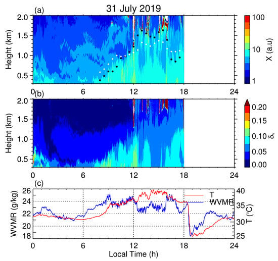
Figure 4.
Time–height contour plots (1 min/3.75 m resolution) of (a) range-squared-corrected signal X; (b) volume depolarization ratio measured by Wuhan University 532 nm polarization lidar on the 31st of July, 2019; and (c) diurnal variation of the surface temperature (T) and WVMR, recorded by a co-located surface weather station. Note that shallow cumuli rapidly formed and vanished at the top edge of the convective boundary layer between 12:00 and 16:30 LT when both the near-surface air temperature and water vapor mixing ratio were high.
Figure 5a presents four sequential 1 min profiles of BSR and , displaying a quasi-complete CBL cumulus cloud event from 12:49 to 12:52 LT on the 31st of July, 2019. As seen from Figure 5b, the cumulus started forming at 12:47 LT, which could be recognized via the all-sky image (but not in the FOV of the lidar) at 12:49 LT, came into the FOV of the lidar at 12:51 LT and broke into dissipation at 12:53 LT. According to Figure 5a, the initial stage of the cumulus formation was not captured by our lidar at 12:49 LT. However, the evolution and dissipation processes from 12:50 to 12:52 LT were recorded. The cumulus cloud base was around 0.47 km (sub-cloud zone thickness) above the LCL (~1.05 km). Similar to the profile structure of the first event, an increment with height for the BSR and a slow decrement for the could be found from the profiles at 12:50 and 12:51 LT. In addition, the cumulus cloud base at 12:51 LT was ~1.62 km, about ~0.11 km higher than that at 12:50 LT. This height bias might be due to the sub-cloud air mass updraft during the two minutes. Note that a microlayer stratification structure could be found below the cloud base at 12:51 LT. The cloud peak BSR was ~326 (at ~1.68 km for 12:50 LT) and ~478 (at ~1.7 km for 12:51 LT), respectively. The cloud thickness did not exceed 200 m throughout the whole event. From the last profile at 12:52 LT, the height range between ~1.51 and 1.68 km was still rich of upward transported aerosols and locally condensed water droplets.
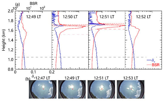
Figure 5.
Same as Figure 3, but for a short-duration cumulus cloud event during 12:49–12:52 LT on the 31st of July, 2019. (a) Profiles of lidar backscatter ratio (R, red) and volume depolarization ratio (, blue). (b) Photographs of the sky recorded by a ground-based camera. Note that this cumulus cloud formed and vanished in a time scale of 1–2 min.
3.3. Statistical Characteristics of the CBL Cumulus
The two cases along with two events in Section 3.1 and Section 3.2 presented some similar features. Hereafter, statistics were made to explore whether these features are ubiquitous for CBL cumuli.
3.3.1. Seasonal Distribution
Based on 848 day lidar observations from 2011 to 2019 at Wuhan, the monthly occurrence of the CBL cumulus is displayed in Figure 6. A total of 117 cumulus cloud days were identified. The observation days for each month are over 45, except for February when the lidar might stop operation due to the traditional Chinese Spring Festival vacation. The majority (~74%) of the cumulus days occur in summer, with corresponding occurrence frequency of ~44% (July), ~32% (August), and ~24% (June), respectively. About 26% of the cumulus days occur in late spring (April, May) and early autumn (September, October). No cumulus events are observed in the period from November to March. Wuhan’s climate is humid subtropical with abundant rainfall in summer and four distinctive seasons. The summer is humid along with strong solar radiation, providing moisture and lifting energy for the cumulus formation. Hence, the cumulus is more likely to form via convective lifting during summertime.
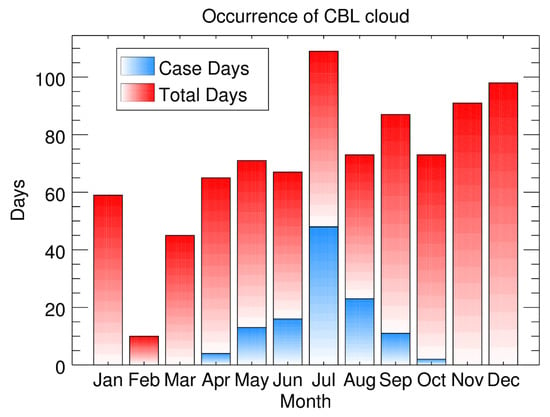
Figure 6.
Monthly occurrence statistics of the shallow cumulus days based on the 848 day lidar observations from 2011 to 2019 at Wuhan, China (30.5°N, 114.4°E). The red bar represents the number of lidar observational days in each month, while the blue bar denotes the number of cumulus cloud days. A total of 117 cumulus cloud days were identified from the 848 day lidar observations. Each cumulus cloud day contained at least 10 cumulus cloud events.
3.3.2. Occurrence Time and Duration
Figure 7 shows (a) the occurrence time of CBL cumulus and (b) the duration of CBL cumulus for the 3047 shallow cumulus cloud events observed from 2011 to 2019. According to Figure 7a, the overwhelming majority (95%) of the CBL cumulus occurs between 09:00 and 18:00 LT, which is consistent with the convective boundary layer evolution as well as the convection strength. From Figure 7b, most of the events (92%) have a duration shorter than 10 min. The mean cumulus residence time in the FOV of the lidar is 4 min. The cloud duration distribution presents a positive skew, indicating that the observed CBL cumuli over Wuhan are dominated by short-duration clouds. The seasonal difference is not apparent for occurrence time and duration.
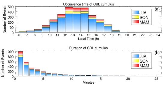
Figure 7.
Distributions of (a) occurrence time (local time) and (b) duration time for a total of 3047 shallow cumulus cloud events observed from 2011 to 2019 at Wuhan, China. The blue bar, yellow bar, and red bar represent, respectively, the number of events in summer (June, July, and August), autumn (September, October, and November), and spring (March, April, and May). Note that the cumulus clouds formed mostly (>95%) during the period of 09:00–18:00 LT, while their duration mostly (>92%) ranged from 1 to 10 min.
3.3.3. Cumulus Height Statistics
Figure 8 gives the statistical distributions of the CBL cumulus base height, top height, peak height, and geometrical thickness between 2011 and 2019. Figure 8a indicates that the CBL cumulus mostly (~72% out of all the events) occurs in a height range of 0.9–1.7 km. The average cloud base height is ~1.3 ± 0.38 km. According to Kong and Yi [39], the mean value of the maximum CBL height under fair weather conditions over our station is 1.24 km in spring and 1.27 km in summer, respectively. The average CBL cloud base height is slightly above the fair weather maximum CBL height, suggesting the cumuli are more likely to form at the top of the CBL. From Figure 8b, c, the cumulus top and peak are mostly located at the height range of 1.1–1.9 km (~70%) and 1.1–1.7 km (~70%), respectively. The average cumulus top height is ~1.51 ± 0.4 km and the peak height ~1.41 ± 0.14 km. Figure 8d shows that the CBL cumuli over Wuhan are dominated by shallow cumulus (70% of the events have a thickness of <250 m and the average is ~210 m). The seasonal difference is not apparent for cloud base/top/peak height, and thickness.
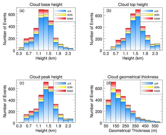
Figure 8.
Distributions of (a) cloud base, (b) cloud top, (c) cloud peak heights, and (d) cloud geometrical thickness for the total of 3047 shallow cumulus cloud events observed from 2011 to 2019 at Wuhan, China. The blue bar, yellow bar, and red bar represent the number of events in summer (June, July, and August), in autumn (September, October, and November), and in Spring (March, April, and May), respectively.
The LCL versus the cumulus base height pertinent to 2744 cumulus events from 2011 to 2019 is plotted in Figure 9. Unlike the results from [29] (a good agreement between the LCL and the cloud base height), the cloud base height over Wuhan is overwhelmingly higher than the pertinent LCL. 96% (2626 out of 2744) of the events present this situation and the average bias between the cloud base height and LCL is 308 ± 254 m. The possible explanation is as follows: the LCL is calculated based on surface temperature, and RH is the level where the updraft air mass becomes saturated; however, the air mass is likely to overshoot this level due to inertia. Therefore, it can be speculated that rapid condensation of updraft air mass will occur in the sub-cloud zone during the abovementioned process; accordingly, the will present a decreasing trend along the height. A similar structure could be found from the WVMR structure of the tropical atmosphere in Garstang and Betts [53]. The WVMR in the sub-cloud zone presented a decrease along height, meaning that water droplets formed increasingly along the height.
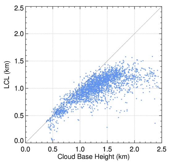
Figure 9.
Scatterplot showing the relationship between the cloud base height of the lidar-observed shallow cumuli and lifting condensation level (LCL) calculated from the data of surface temperature and relative humidity several minutes (depending on the cloud base height and an assumption of 1 m s−1 upward velocity of the air parcel [54]) before corresponding shallow cumulus occurred. In this plot, only 2744 shallow cumulus events are included because the data of corresponding surface temperature and relative humidity are available therein.
In order to verify the decreasing trend along with height in the sub-cloud zone, comparisons of at the LCL level and cloud base level are plotted in Figure 10. The LCL and cloud base were an average from eight height intervals which were above the LCL and below the cloud base, respectively. 1515 out of the 1941 (78%) counted events (803 events were excluded due to the low SNR) presented a decrease trend along height. The average decrease between these two levels is 0.0045 ± 0.0058.
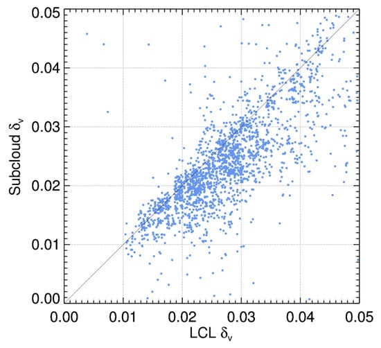
Figure 10.
Scatterplot showing the relationship between the values of the volume depolarization ratio at the lifting condensation level (LCL) and at cloud base level based on a total of 1941 shallow cumulus events. Note that out of the 1941 events, 78% are characterized by larger values at the LCL height than that at the cloud base height, exhibiting a gradually increasing condensation with height in the sub-cloud region.
3.3.4. Surface Meteorological Parameters
The surface T versus WVMR for cumulus days during 2011–2019 are plotted in Figure 11. As seen from Figure 11, the majority (>79%) of the cumulus events occurred under the surface meteorological conditions of the near-surface temperature being higher than 30 °C and the WVMR larger than 15 g kg−1. The cumulus day surface T versus WVMR presents a clustering pattern with a linear correlation coefficient of ~0.81. The average near-surface WVMR in Lareau, Zhang, and Klein [14] was lower than 15 g kg−1, while the result at our site was 19.9 g kg−1 (a relatively large value). We infer that high near-surface temperature (mostly in summertime under fair-weather) is more likely to cause disturbances [55] and thus initiate thermal convection, promoting the formation of cumulus.
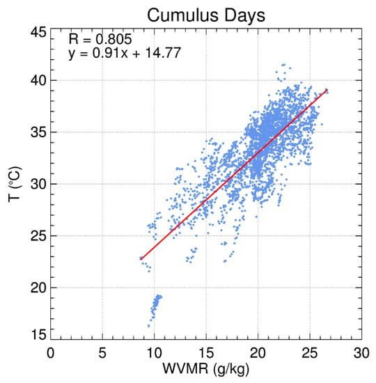
Figure 11.
Scatterplot showing the relationship between surface air temperature (T) and water vapor mixing ratio (r) associated with 2744 shallow cumulus cloud events observed by our polarization lidar. Note that the shallow cumulus cloud events occurred mostly (>79%) when the near-surface temperature T was higher than 30 °C and the WVMR larger than 15 g kg−1.
4. Discussion
Fair-weather cumulus could be classified as “forced” and “active” cumulus [22]. The “forced” cumulus presents a thinner vertical extent or physical geometrical thickness and a shorter lifetime [56]. “Forced” cumulus forms via the convective lifting of surface thermals and locates at the top edge of the convective boundary layer. The two representative cumulus day cases in Section 3.1 and Section 3.2 exhibited the summer daytime occurrence of “forced” shallow cumulus. The two events were chosen to reflect a clear-cut process for a single shallow cumulus cloud evolving from formation to disappearance that could be simultaneously registered in both the lidar measurement and ground-based camera. Since many factors (e.g., small lidar FOV vs. quite large FOV for the ground camera, multiple shallow cumulus clouds in camera FOV, and wind advection) affect the availability of such cases, the two chosen cases actually represent the best examples in the simultaneous camera and lidar observations depicting the formation and vanishing of the single shallow cumuli. They provide the direct observation of the cloud physics process in the natural atmosphere. However, the temporal resolution of our lidar is 1 min while the cumulus formation and its variation could occur within 1 min. A higher temporal resolution lidar and cloud camera observation could investigate the short-time scale and fine vertical structure of the CBL clouds. A full-day operation polarization lidar with a tilted emitting laser and a much higher time resolution (10 s) has been built by Liu et al. [57], and the finer process-level observations can be expected in the future.
The cloud top determination is very sensitive to the cloud optical depth [58]. The CBL cumuli observed over Wuhan present mostly short duration and small size (according to Figure 7b and cloud images). In this study, the cloud top and cloud geometrical thickness should be underestimated slightly.
The GCMs suffer from errors in the location, timing, and extent of shallow clouds. The statistical study of cumulus can be a dataset from an urban area at a mid-latitude plain site, containing the location, onset time, and thickness information. Meanwhile, other researchers who are interested in using spaceborne instruments to explore the cumulus over different underlying surfaces can refer to our results [25].
5. Conclusions
Two typical CBL cumulus occurrences in fair-weather summer over a megacity at a mid-latitude site was exhibited by polarization lidar, simultaneous surface weather station, and cloud camera measurements. The cumulus was most likely to form at the top of the CBL when the CBL height jumps over the LCL. The clear-cut process-level cumulus formation and its sub-cloud variation were displayed. This provides us a direct observation of the shallow convective cloud in the CBL and deepens our understanding of cloud physics in the low-level atmosphere.
Convective boundary layer clouds were statistically investigated based on extensive polarization lidar measurements on 848 different days from 2011 to 2019 at Wuhan, China (30.5°N, 114.4°E). A total of 3047 individual shallow cumulus events were identified from 117 different days out of the total 848 observational days. The 117 shallow cumulus days (each cumulus cloud day contained at least 10 cumulus cloud events) were distributed between April and October with the maximum occurrence in July. They formed mostly (>95%) in the period of 09:00–18:00 LT while surface air temperature and water vapor mixing ratio were generally larger than 30 °C and 15 g kg−1, respectively.
These fair-weather shallow cumuli occurred at the top edge of the convective boundary layer with a duration of 1–10 min (79% having a duration of 1–5 min) and a geometrical thickness of ~50–600 m (70% having a geometrical thickness less than 250 m). Their cloud base height ranged from 0.5 to 1.9 km. The lifting condensation level (LCL) was estimated to appear ~50–560 m (a mean of 308 ± 254 m) below the cloud base. In the height range from the LCL to the cloud base, the lidar volume depolarization ratio () slightly decreased with increasing altitude, showing a gradually increasing condensation in this sub-cloud region due to penetrative thermals.
The current study provides the statistical results of shallow cumulus cloud properties and formation conditions based on the polarization lidar and surface weather station observations at a 30°N plain site. It supplements the existing data library of locally generated surface-forced shallow cumuli that has been established in terms of long-term continuous ground-based observational data at a couple of sites in the mid-latitude region [14,59,60]. Long-term observations at low-latitude sites are urgently required at present in order to efficiently develop and improve conventional global climate models. In addition, the cumulus cloud formation (mechanism and characteristics) also depends on underlying surface conditions [30,35,36,37,38]. Thus, long-term observations for various underlying surface conditions are also needed. Our polarization lidar can be conveniently deployed in field conditions because of its robust configuration and unattended operation. It is actually a suitable sort of instrument for observing the shallow cumulus clouds over various underlying surfaces in the low-latitude region. In addition to a role in affecting large-scale dynamics, the presence of shallow cumulus clouds reflects a locally intensified vertical turbulent transport of heat, moisture, and momentum [61,62]. The present observations quantify statistically the local surface conditions for cumulus cloud formation that most of the observed cumuli are associated with: high air temperature (>30 °C) and mixing ratio (>15 g kg−1).
Author Contributions
Y.Z. (Yifan Zhan) performed the lidar observation, made the data analysis and wrote the initial manuscript. F.Y. conceived the project, led the research, and finalized the manuscript. F.L., Y.Z. (Yunpeng Zhang) and C.Y. made contributions in establishing the lidar system, auto weather station, and cloud camera. J.Z. and F.L. participated in the scientific discussions. All authors have read and agreed to the published version of the manuscript.
Funding
This work is funded by the National Natural Science Foundation of China through grants 41927804.
Institutional Review Board Statement
Not applicable.
Informed Consent Statement
Not applicable.
Data Availability Statement
Data used to generate the results of this paper are available from the authors upon request (E-mail: yf@whu.edu.cn).
Acknowledgments
The author would like to express thanks to Yunfei Zhang, Yun He, Zhenping Yin, and Wei Wang for advice on data processing as well as on performing lidar observations.
Conflicts of Interest
The authors declare that we have no financial and personal relationships with other people or organizations that can inappropriately influence our work and that this paper was not published before, the funding sponsors had no role in the design of the study; in the collection, analyses, or interpretation of data; in the writing of the manuscript; or in the decision to publish the results.
References
- Stull, R.B. An Introduction to Boundary Layer Meteorology; Springer Science & Business Media: Cham, Switzerland, 2012; Volume 13. [Google Scholar]
- Bonin, T.; Chilson, P.; Zielke, B.; Fedorovich, E. Observations of the Early Evening Boundary-Layer Transition Using a Small Unmanned Aerial System. Bound. Layer Meteorol. 2013, 146, 119–132. [Google Scholar] [CrossRef]
- Danchovski, V. Summertime Urban Mixing Layer Height over Sofia, Bulgaria. Atmosphere 2019, 10, 36. [Google Scholar] [CrossRef]
- Hartmann, D.L.; Ramanathan, V.; Berroir, A.; Hunt, G.E. Earth Radiation Budget data and climate research. Rev. Geophys. 1986, 24, 439–468. [Google Scholar] [CrossRef]
- Kiehl, J.T.; Trenberth, K.E. Earth’s Annual Global Mean Energy Budget. Bull. Am. Meteorol. Soc. 1997, 78, 197–208. [Google Scholar] [CrossRef]
- Stephens, G.L.; Li, J.; Wild, M.; Clayson, C.A.; Loeb, N.; Kato, S.; L’Ecuyer, T.; Stackhouse, P.W.; Lebsock, M.; Andrews, T. An update on Earth’s energy balance in light of the latest global observations. Nat. Geosci. 2012, 5, 691–696. [Google Scholar] [CrossRef]
- Hartmann, D.L.; Ockert-Bell, M.E.; Michelsen, M.L. The Effect of Cloud Type on Earth’s Energy Balance: Global Analysis. J. Clim. 1992, 5, 1281–1304. [Google Scholar] [CrossRef]
- Chen, T.; Rossow, W.B.; Zhang, Y. Radiative Effects of Cloud-Type Variations. J. Clim. 2000, 13, 264–286. [Google Scholar] [CrossRef]
- Matus, A.V.; L’Ecuyer, T.S. The role of cloud phase in Earth’s radiation budget. J. Geophys. Res. Atmos. 2017, 122, 2559–2578. [Google Scholar] [CrossRef]
- Chahine, M.T. The hydrological cycle and its influence on climate. Nature 1992, 359, 373–380. [Google Scholar] [CrossRef]
- Wild, M.; Liepert, B. The Earth radiation balance as driver of the global hydrological cycle. Environ. Res. Lett. 2010, 5. [Google Scholar] [CrossRef]
- Bony, S.; Stevens, B.; Frierson, D.M.W.; Jakob, C.; Kageyama, M.; Pincus, R.; Shepherd, T.G.; Sherwood, S.C.; Siebesma, A.P.; Sobel, A.H.; et al. Clouds, circulation and climate sensitivity. Nat. Geosci. 2015, 8, 261–268. [Google Scholar] [CrossRef]
- Zelinka, M.D.; Randall, D.A.; Webb, M.J.; Klein, S.A. Clearing clouds of uncertainty. Nat. Clim. Chang. 2017, 7, 674–678. [Google Scholar] [CrossRef]
- Lareau, N.P.; Zhang, Y.; Klein, S.A. Observed Boundary Layer Controls on Shallow Cumulus at the ARM Southern Great Plains Site. J. Atmos. Sci. 2018, 75, 2235–2255. [Google Scholar] [CrossRef]
- Craven, J.P.; Jewell, R.E.; Brooks, H.E. Comparison between Observed Convective Cloud-Base Heights and Lifting Condensation Level for Two Different Lifted Parcels. Weather Forecast. 2002, 17, 885–890. [Google Scholar] [CrossRef]
- Warren, G.; Hahn, J.; London, J.; Chervin, M.; Jenne, L. Global Distribution of Total Cloud Cover and Cloud Type Amounts Over Land; National Center for Atmospheric Research: Boulder, CO, USA, 1986. [Google Scholar]
- Warren, S.; Hahn, C.J.; London, J.; Chervin, R. Global Distribution of Total Cloud Cover and Cloud Type Amounts Over the Ocean; National Center for Atmospheric Research: Boulder, CO, USA, 1988. [Google Scholar]
- Liou, K.-N. On the Absorption, Reflection and Transmission of Solar Radiation in Cloudy Atmospheres. J. Atmos. Sci. 1976, 33, 798–805. [Google Scholar] [CrossRef]
- Huang, T.; Yim, S.H.-l.; Yang, Y.; Lee, O.S.-m.; Lam, D.H.-y.; Cheng, J.C.-h.; Guo, J. Observation of Turbulent Mixing Characteristics in the Typical Daytime Cloud-Topped Boundary Layer over Hong Kong in 2019. Remote Sens. 2020, 12, 1533. [Google Scholar] [CrossRef]
- Lawson, R.P.; Woods, S.; Morrison, H. The Microphysics of Ice and Precipitation Development in Tropical Cumulus Clouds. J. Atmos. Sci. 2015, 72, 2429–2445. [Google Scholar] [CrossRef]
- Rauber, R.M.; Stevens, B.; III, H.T.O.; Knight, C.; Albrecht, B.A.; Blyth, A.M.; Fairall, C.W.; Jensen, J.B.; Lasher-Trapp, S.G.; Mayol-Bracero, O.L.; et al. Rain in Shallow Cumulus Over the Ocean: The RICO Campaign. Bull. Am. Meteorol. Soc. 2007, 88, 1912–1928. [Google Scholar] [CrossRef]
- Stull, R.B. A Fair-Weather Cumulus Cloud Classification Scheme for Mixed-Layer Studies. J. Clim. Appl. Meteorol. 1985, 24, 49–56. [Google Scholar] [CrossRef]
- Zhang, Y.; Klein, S.A.; Fan, J.; Chandra, A.S.; Kollias, P.; Xie, S.; Tang, S. Large-Eddy Simulation of Shallow Cumulus over Land: A Composite Case Based on ARM Long-Term Observations at Its Southern Great Plains Site. J. Atmos. Sci. 2017, 74, 3229–3251. [Google Scholar] [CrossRef]
- Benner, T.C.; Curry, J.A. Characteristics of small tropical cumulus clouds and their impact on the environment. J. Geophys. Res. Atmos. 1998, 103, 28753–28767. [Google Scholar] [CrossRef]
- Medeiros, B.; Nuijens, L.; Antoniazzi, C.; Stevens, B. Low-latitude boundary layer clouds as seen by CALIPSO. J. Geophys. Res. Atmos. 2010, 115, 12. [Google Scholar] [CrossRef]
- Li, Y.; Zhang, M. Cumulus over the Tibetan Plateau in the Summer Based on CloudSat–CALIPSO Data. J. Clim. 2016, 29, 1219–1230. [Google Scholar] [CrossRef]
- Rodts, S.M.A.; Duynkerke, P.G.; Jonker, H.J.J. Size Distributions and Dynamical Properties of Shallow Cumulus Clouds from Aircraft Observations and Satellite Data. J. Atmos. Sci. 2003, 60, 1895–1912. [Google Scholar] [CrossRef]
- Ansmann, A.; Fruntke, J.; Engelmann, R. Updraft and downdraft characterization with Doppler lidar: Cloud-free versus cumuli-topped mixed layer. Atmos. Chem. Phys. 2010, 10, 7845–7858. [Google Scholar] [CrossRef]
- Berg, L.K.; Kassianov, E.I. Temporal Variability of Fair-Weather Cumulus Statistics at the ACRF SGP Site. J. Clim. 2008, 21, 3344–3358. [Google Scholar] [CrossRef]
- Chandra, A.S.; Kollias, P.; Giangrande, S.E.; Klein, S.A. Long-Term Observations of the Convective Boundary Layer Using Insect Radar Returns at the SGP ARM Climate Research Facility. J. Clim. 2010, 23, 5699–5714. [Google Scholar] [CrossRef]
- Lamer, K.; Kollias, P. Observations of fair-weather cumuli over land: Dynamical factors controlling cloud size and cover. Geophys. Res. Lett. 2015, 42, 8693–8701. [Google Scholar] [CrossRef]
- Cotton, W.R.; Bryan, G.; van den Heever, S.C. Storm and Cloud Dynamics; Elsevier Science: New York, NY, USA, 2010. [Google Scholar]
- Dai, A.; Trenberth, K.E. The Diurnal Cycle and Its Depiction in the Community Climate System Model. J. Clim. 2004, 17, 930–951. [Google Scholar] [CrossRef]
- Park, S.; Bretherton, C.S. The University of Washington Shallow Convection and Moist Turbulence Schemes and Their Impact on Climate Simulations with the Community Atmosphere Model. J. Clim. 2009, 22, 3449–3469. [Google Scholar] [CrossRef]
- Banta, R.M. Daytime Boundary-Layer Evolution over Mountainous Terrain. Part 1: Observations of the Dry Circulations. Mon. Weather Rev. 1984, 112, 340–356. [Google Scholar] [CrossRef]
- Luo, T.; Yuan, R.; Wang, Z. Lidar-based remote sensing of atmospheric boundary layer height over land and ocean. Atmos. Meas. Tech. 2014, 7, 173–182. [Google Scholar] [CrossRef]
- Pal, S.; Xueref-Remy, I.; Ammoura, L.; Chazette, P.; Gibert, F.; Royer, P.; Dieudonné, E.; Dupont, J.C.; Haeffelin, M.; Lac, C.; et al. Spatio-temporal variability of the atmospheric boundary layer depth over the Paris agglomeration: An assessment of the impact of the urban heat island intensity. Atmos. Environ. 2012, 63, 261–275. [Google Scholar] [CrossRef]
- Wang, J.; Chagnon, F.J.F.; Williams, E.R.; Betts, A.K.; Renno, N.O.; Machado, L.A.T.; Bisht, G.; Knox, R.; Bras, R.L. Impact of deforestation in the Amazon basin on cloud climatology. Proc. Natl. Acad. Sci. USA 2009, 106, 3670–3674. [Google Scholar] [CrossRef] [PubMed]
- Kong, W.; Yi, F. Convective boundary layer evolution from lidar backscatter and its relationship with surface aerosol concentration at a location of a central China megacity. J. Geophys. Res. Atmos. 2015, 120, 7928–7940. [Google Scholar] [CrossRef]
- Fernald, F.G. Analysis of atmospheric lidar observations: Some comments. Appl. Opt. 1984, 23, 652–653. [Google Scholar] [CrossRef]
- Müller, D.; Ansmann, A.; Mattis, I.; Tesche, M.; Wandinger, U.; Althausen, D.; Pisani, G. Aerosol-type-dependent lidar ratios observed with Raman lidar. J. Geophys. Res. Atmos. 2007, 112. [Google Scholar] [CrossRef]
- O’Connor, E.J.; Illingworth, A.J.; Hogan, R.J. A Technique for Autocalibration of Cloud Lidar. J. Atmos. Ocean. Technol. 2004, 21, 777–786. [Google Scholar] [CrossRef]
- Comerón, A.; Rocadenbosch, F.; López, M.A.; Rodríguez, A.; Muñoz, C.; García-Vizcaíno, D.; Sicard, M. Effects of noise on lidar data inversion with the backward algorithm. Appl. Opt. 2004, 43, 2572–2577. [Google Scholar] [CrossRef]
- Hennemuth, B.; Lammert, A. Determination of the Atmospheric Boundary Layer Height from Radiosonde and Lidar Backscatter. Bound. Layer Meteorol. 2006, 120, 181–200. [Google Scholar] [CrossRef]
- Freudenthaler, V.; Esselborn, M.; Wiegner, M.; Heese, B.; Tesche, M.; Ansmann, A.; Müller, D.; Althausen, D.; Wirth, M.; Fix, A. Depolarization ratio profiling at several wavelengths in pure Saharan dust during SAMUM 2006. Tellus B Chem. Phys. Meteorol. 2009, 61, 165–179. [Google Scholar] [CrossRef]
- Sassen, K. The Polarization Lidar Technique for Cloud Research: A Review and Current Assessment. Bull. Am. Meteorol. Soc. 1991, 72, 1848–1866. [Google Scholar] [CrossRef]
- Tan, W.; Li, C.; Liu, Y.; Meng, X.; Wu, Z.; Kang, L.; Zhu, T. Potential of Polarization Lidar to Profile the Urban Aerosol Phase State during Haze Episodes. Environ. Sci. Technol. Lett. 2020, 7, 54–59. [Google Scholar] [CrossRef]
- Platt, C.; Young, S.; Carswell, A.; Pal, S.; McCormick, M.; Winker, D.; DelGuasta, M.; Stefanutti, L.; Eberhard, W.; Hardesty, M. The experimental cloud lidar pilot study (ECLIPS) for cloud-radiation research. Bull. Am. Meteorol. Soc. 1994, 75, 1635–1654. [Google Scholar] [CrossRef]
- Wang, Z.; Sassen, K. Cloud type and macrophysical property retrieval using multiple remote sensors. J. Appl. Meteorol. 2001, 40, 1665–1682. [Google Scholar] [CrossRef]
- Rogers, R.R. A Short Course in Cloud Physics/ by R.R. Rogers and M.K. Yau; Pergamon Press: Oxford, UK; New York, NY, USA, 1989. [Google Scholar]
- Lawrence, M.G. The Relationship between Relative Humidity and the Dewpoint Temperature in Moist Air: A Simple Conversion and Applications. Bull. Am. Meteorol. Soc. 2005, 86, 225–234. [Google Scholar] [CrossRef]
- Pal, S.; Haeffelin, M.; Batchvarova, E. Exploring a geophysical process-based attribution technique for the determination of the atmospheric boundary layer depth using aerosol lidar and near-surface meteorological measurements. J. Geophys. Res. Atmos. 2013, 118, 9277–9295. [Google Scholar] [CrossRef]
- Garstang, M.; Betts, A.K. a review of the tropical boundary layer and cumulus convection: Structure, parameterization, and modeling. Bull. Am. Meteorol. Soc. 1974, 55, 1195–1205. [Google Scholar] [CrossRef]
- Warner, J. The Microstructure of Cumulus Cloud. Part II. The Effect on Droplet Size Distribution of the Cloud Nucleus Spectrum and Updraft Velocity. J. Atmos. Sci. 1969, 26, 1272–1282. [Google Scholar] [CrossRef][Green Version]
- Wallace, J.M.; Hobbs, P.V. Atmos. Sci. Introd. Survey; Elsevier Science: New York, NY, USA, 2006. [Google Scholar]
- Zhang, Y.; Klein, S.A. Factors Controlling the Vertical Extent of Fair-Weather Shallow Cumulus Clouds over Land: Investigation of Diurnal-Cycle Observations Collected at the ARM Southern Great Plains Site. J. Atmos. Sci. 2013, 70, 1297–1315. [Google Scholar] [CrossRef]
- Liu, F.; Yi, F.; Yin, Z.; Zhang, Y.; He, Y.; Yi, Y. Measurement report: Characteristics of clear-day convective boundary layer and associated entrainment zone as observed by a ground-based polarization lidar over Wuhan (30.5°N, 114.4°E). Atmos. Chem. Phys. 2021, 21, 2981–2998. [Google Scholar] [CrossRef]
- Yin, Z.; Yi, F.; He, Y.; Liu, F.; Yu, C.; Zhang, Y.; Wang, W. Asian dust impacts on heterogeneous ice formation at Wuhan based on polarization lidar measurements. Atmos. Environ. 2021, 246, 118166. [Google Scholar] [CrossRef]
- Xie, S.; McCoy, R.B.; Klein, S.A.; Cederwall, R.T.; Wiscombe, W.J.; Jensen, M.P.; Johnson, K.L.; Clothiaux, E.E.; Gaustad, K.L.; Long, C.N.; et al. CLOUDS AND MORE: ARM Climate Modeling Best Estimate Data: A New Data Product for Climate Studies. Bull. Am. Meteorol. Soc. 2010, 91, 13–20. [Google Scholar] [CrossRef]
- Neggers, R.A.J.; Siebesma, A.P. Constraining a System of Interacting Parameterizations through Multiple-Parameter Evaluation: Tracing a Compensating Error between Cloud Vertical Structure and Cloud Overlap. J. Clim. 2013, 26, 6698–6715. [Google Scholar] [CrossRef]
- Tiedtke, M.; Heckley, W.A.; Slingo, J. Tropical forecasting at ECMWF: The influence of physical parametrization on the mean structure of forecasts and analyses. Q. J. Royal Meteorol. Soc. 1988, 114, 639–664. [Google Scholar] [CrossRef]
- Siebesma, A.P.; Bretherton, C.S.; Brown, A.; Chlond, A.; Cuxart, J.; Duynkerke, P.G.; Jiang, H.; Khairoutdinov, M.; Lewellen, D.; Moeng, C.-H.; et al. A Large Eddy Simulation Intercomparison Study of Shallow Cumulus Convection. J. Atmos. Sci. 2003, 60, 1201–1219. [Google Scholar] [CrossRef]
Publisher’s Note: MDPI stays neutral with regard to jurisdictional claims in published maps and institutional affiliations. |
© 2021 by the authors. Licensee MDPI, Basel, Switzerland. This article is an open access article distributed under the terms and conditions of the Creative Commons Attribution (CC BY) license (http://creativecommons.org/licenses/by/4.0/).