
A New Application of the Disturbance Index for Fire Severity in Coastal Dunes


Abstract
:
1. Introduction
2. Materials and Methods
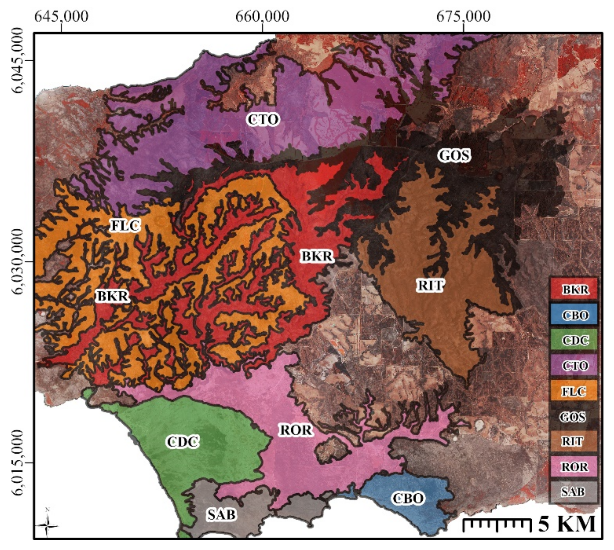
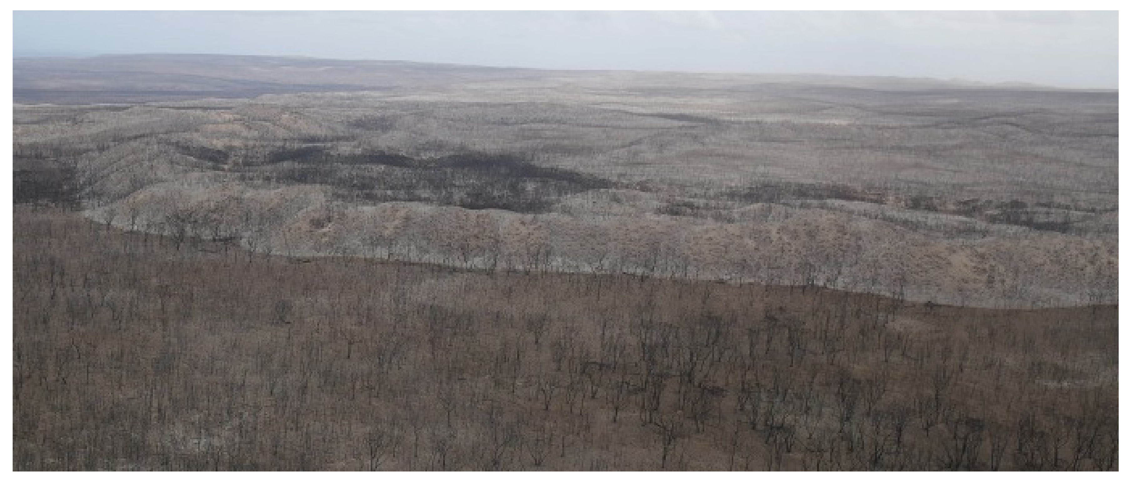
2.1. Study Area
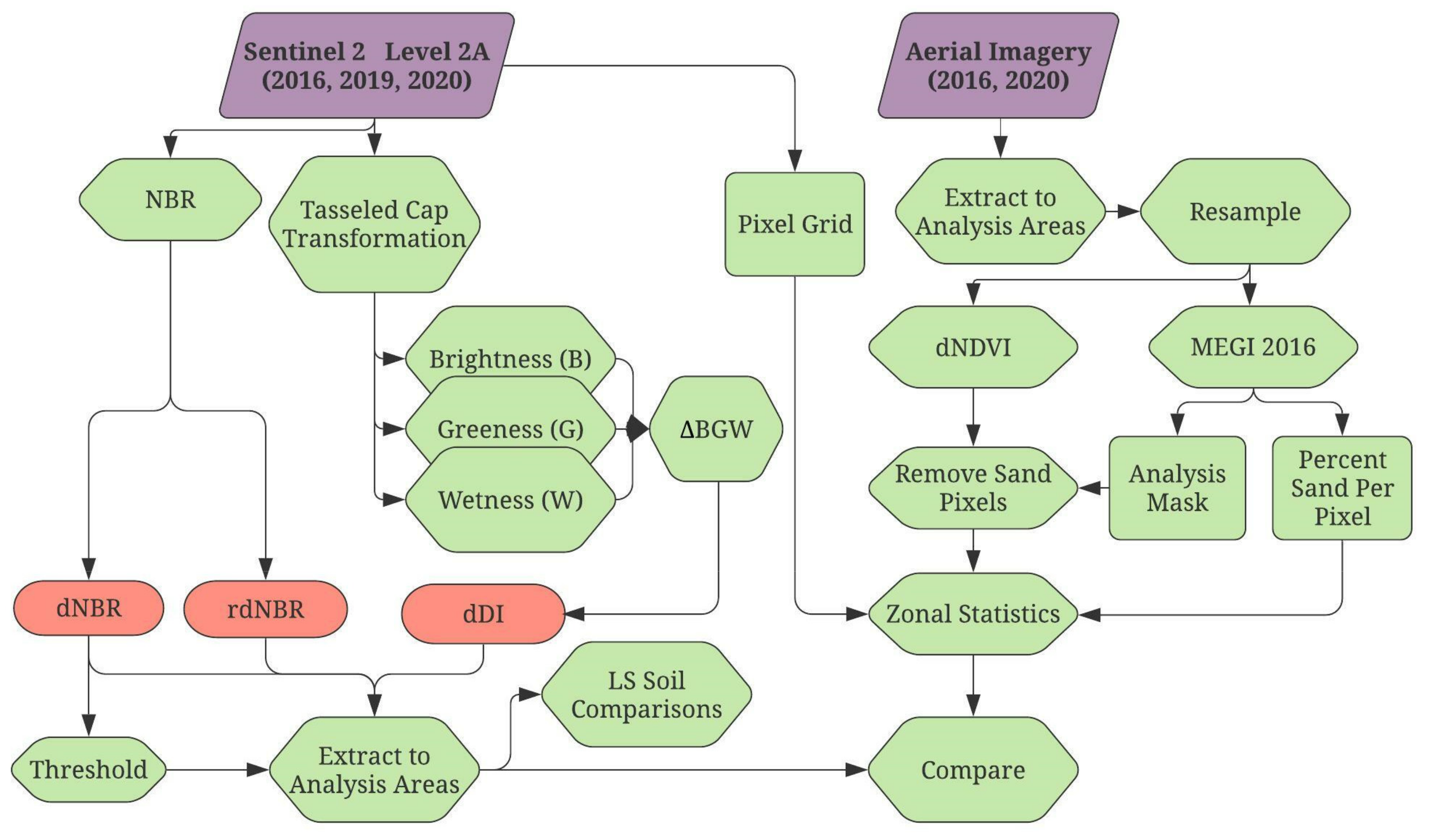
2.2. Datasets and Pre-Processing
2.3. Index Design
2.4. Satellite Fire Severity
2.5. High Resolution Aerial Assessment of Fire Severity
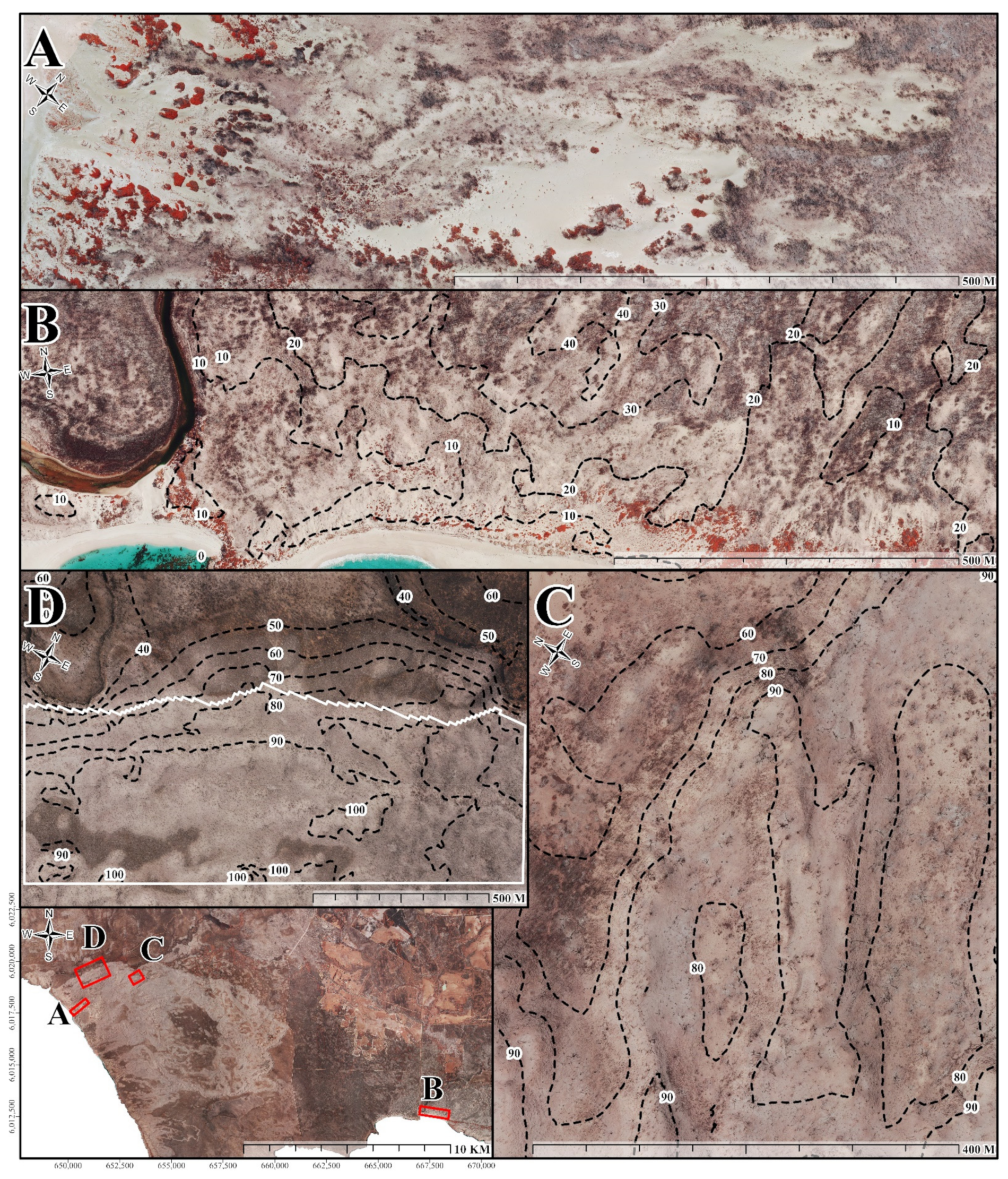
2.5.1. Representative Dune Sites
2.5.2. Measuring Fire Severity from Aerial Imagery
2.6. Comparisons of Satellite-Derived Fire Severity
2.7. Comparisons to Aerial Fire Severity
3. Results
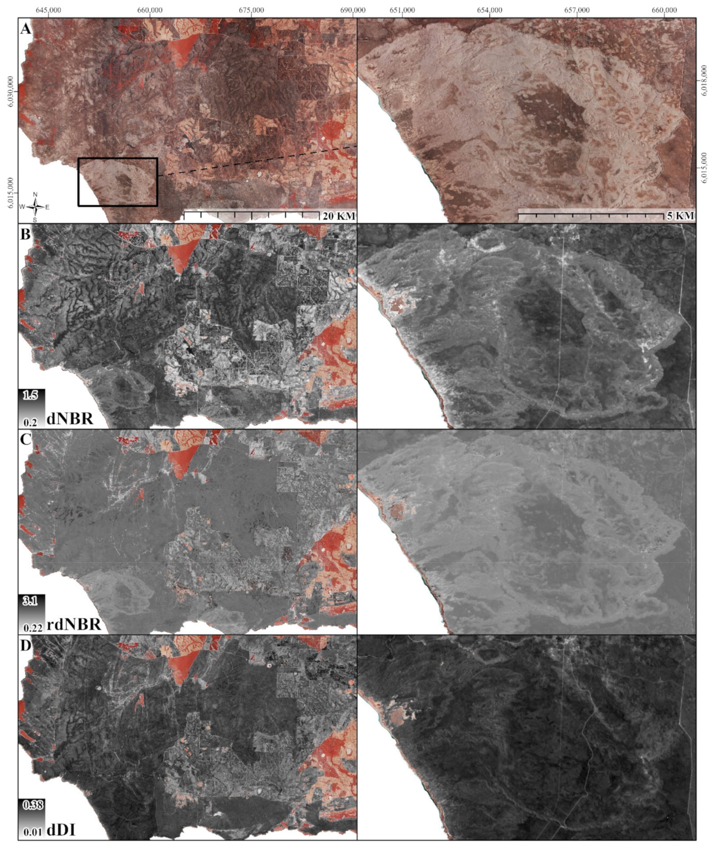
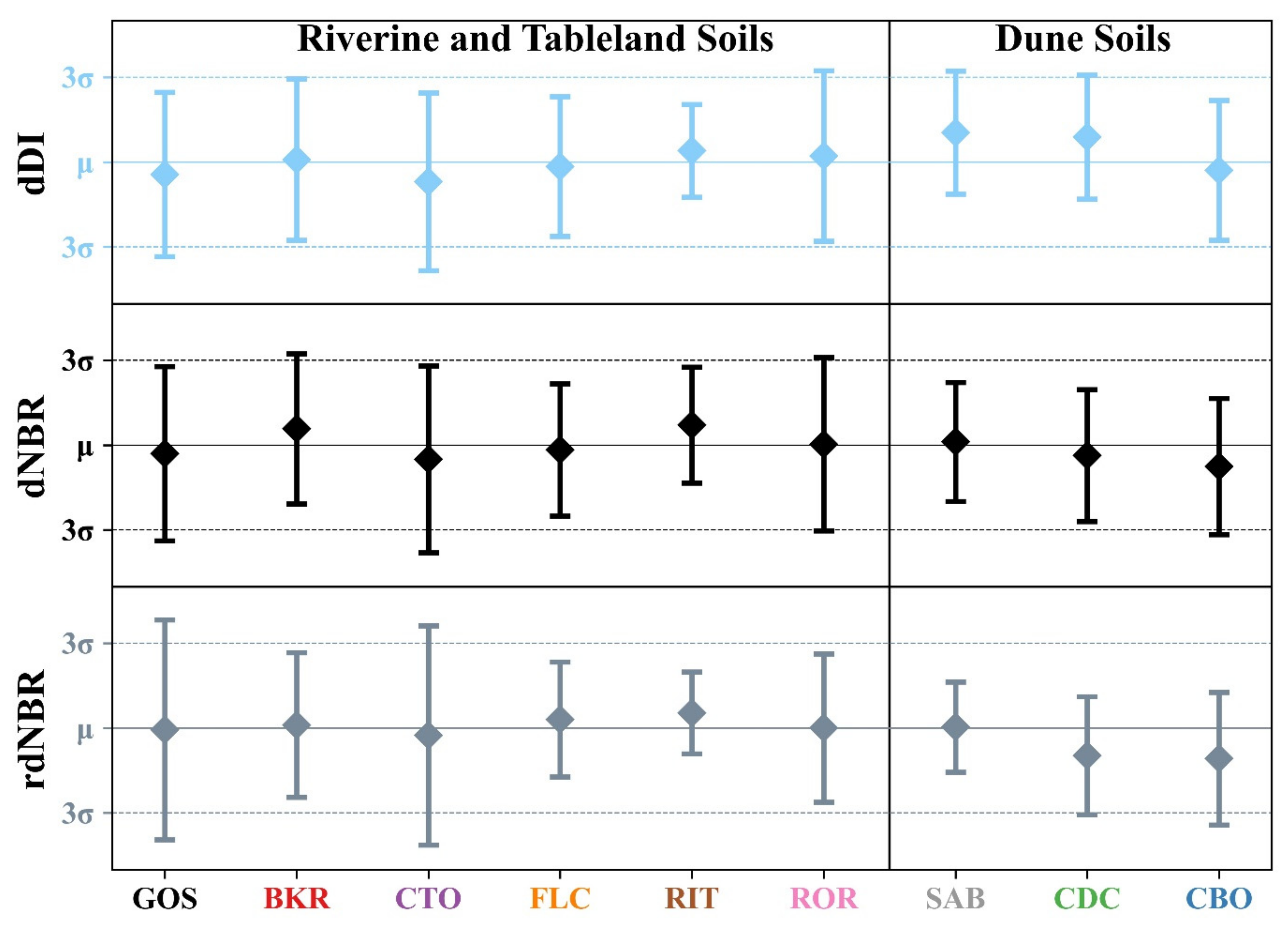
3.1. Differenced Disturbance Index
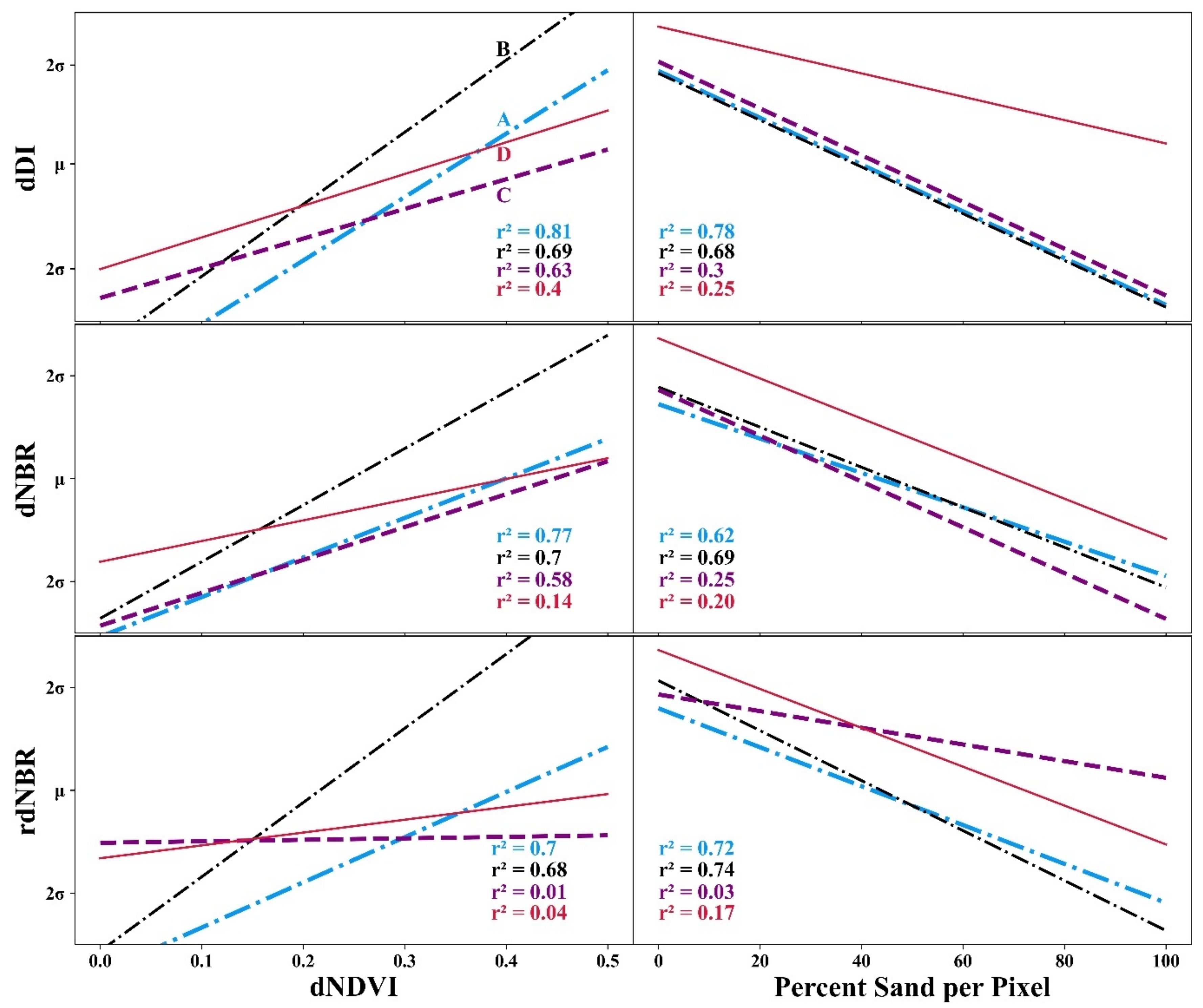
3.2. Comparisons of Satellite Fire Severity
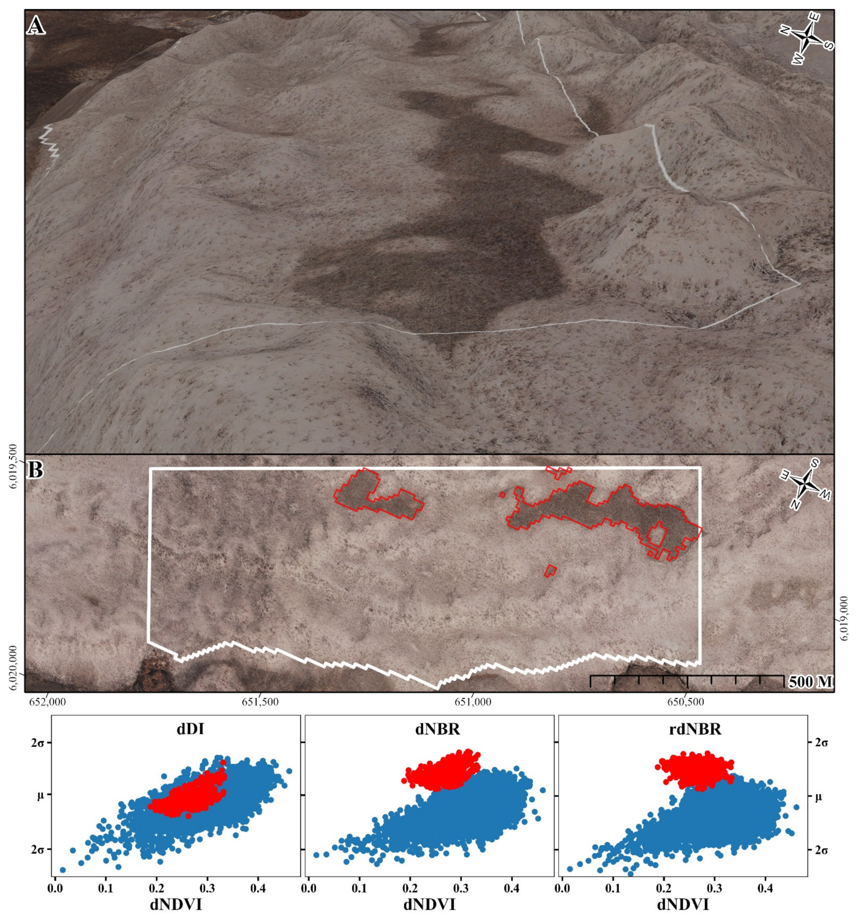
3.3. Comparison with Aerial Fire Severity
4. Discussion
5. Conclusions
Author Contributions
Funding
Data Availability Statement
Acknowledgments
Conflicts of Interest
Appendix A

Appendix B
| LS | dDI-dNBR | dDI-rdNBR | dNBR-rdNBR |
|---|---|---|---|
| GOS | 0.08 | 0.18 | 0.11 |
| BKR | 0.28 | 0.04 | 0.27 |
| CTO | 0.11 | 0.20 | 0.10 |
| FLC | 0.00 | 0.31 | 0.32 |
| RIT | 0.25 | 0.12 | 0.16 |
| ROR | 0.09 | 0.12 | 0.03 |
| SAB | 0.55 | 0.65 | 0.07 |
| CDC | 0.64 | 0.80 | 0.38 |
| CBO | 0.27 | 0.44 | 0.20 |
References
- Seidl, R.; Thom, D.; Kautz, M.; Martin-Benito, D.; Peltoniemi, M.; Vacchiano, G.; Wild, J.; Ascoli, D.; Petr, M.; Honkaniemi, J.; et al. Forest disturbances under climate change. Nat. Clim. Chang. 2017, 7, 395–402. [Google Scholar] [CrossRef] [Green Version]
- Keeley, J.E. Seed-Germination Patterns in Fire-Prone Mediterranean-Climate Regions. In Ecology and Biogeography of Mediterranean Ecosystems in Chile, California, and Australia; Arroyo, M.T.K., Zedler, P.H., Fox, M.D., Eds.; Springer: New York, NY, USA, 1995; pp. 239–273. [Google Scholar]
- Wellington, A.; Noble, I. Post-fire recruitment and mortality in a population of the mallee Eucalyptus incrassata in semi-arid, south-eastern Australia. J. Ecol. 1985, 73, 645–656. [Google Scholar] [CrossRef]
- Wright, B.R.; Clarke, P.J. Fire regime (recency, interval and season) changes the composition of spinifex (Triodia spp.)-dominated desert dunes. Aust. J. Bot. 2007, 55, 709–724. [Google Scholar] [CrossRef]
- Barbero, R.; Abatzoglou, J.T.; Pimont, F.; Ruffault, J.; Curt, T. Attributing Increases in Fire Weather to Anthropogenic Climate Change Over France. Front. Earth Sci. 2020, 8, 104. [Google Scholar] [CrossRef]
- Keeley, J.E.; Syphard, A.D. Climate Change and Future Fire Regimes: Examples from California. Geosciences 2016, 6, 37. [Google Scholar] [CrossRef] [Green Version]
- Turton, S.M. Geographies of bushfires in Australia in a changing world. Geogr. Res. 2020, 58, 313–315. [Google Scholar] [CrossRef]
- Tran, B.N.; Tanase, M.A.; Bennett, L.T.; Aponte, C. High-severity wildfires in temperate Australian forests have increased in extent and aggregation in recent decades. PLoS ONE 2020, 15, e0242484. [Google Scholar] [CrossRef] [PubMed]
- Storey, E.A.; Stow, D.A.; O’Leary, J.F.; Davis, F.W.; Roberts, D.A. Does short-interval fire inhibit postfire recovery of chaparral across southern California? Sci. Total Environ. 2021, 751, 142271. [Google Scholar] [CrossRef] [PubMed]
- Bennett, L.T.; Bruce, M.J.; MacHunter, J.; Kohout, M.; Tanase, M.A.; Aponte, C. Mortality and recruitment of fire-tolerant eucalypts as influenced by wildfire severity and recent prescribed fire. For. Ecol. Manag. 2016, 380, 107–117. [Google Scholar] [CrossRef]
- Levin, N.; Levental, S.; Morag, H. The effect of wildfires on vegetation cover and dune activity in Australia’s desert dunes: A multisensor analysis. Int. J. Wildland Fire 2012, 21, 459–475. [Google Scholar] [CrossRef]
- Schoennagel, T.; Smithwick, E.A.; Turner, M.G. Landscape heterogeneity following large fires: Insights from Yellowstone National Park, USA. Int. J. Wildland Fire 2009, 17, 742–753. [Google Scholar] [CrossRef]
- Turner, M.G.; Hargrove, W.W.; Gardner, R.H.; Romme, W.H. Effects of Fire on Landscape Heterogeneity in Yellowstone-National-Park, Wyoming. J. Veg. Sci. 1994, 5, 731–742. [Google Scholar] [CrossRef] [Green Version]
- Coppoletta, M.; Merriam, K.E.; Collins, B.M. Post-fire vegetation and fuel development influences fire severity patterns in reburns. Ecol. Appl. 2016, 26, 686–699. [Google Scholar] [CrossRef] [PubMed]
- Mathews, L.E.H.; Kinoshita, A.M. Vegetation and Fluvial Geomorphology Dynamics after an Urban Fire. Geosciences 2020, 10, 317. [Google Scholar] [CrossRef]
- Chuvieco, E.; Mouillot, F.; van der Werf, G.R.; San Miguel, J.; Tanase, M.; Koutsias, N.; Garcia, M.; Yebra, M.; Padilla, M.; Gitas, I.; et al. Historical background and current developments for mapping burned area from satellite Earth observation. Remote Sens. Environ. 2019, 225, 45–64. [Google Scholar] [CrossRef]
- Gibson, R.; Danaher, T.; Hehir, W.; Collins, L. A remote sensing approach to mapping fire severity in south-eastern Australia using sentinel 2 and random forest. Remote Sens. Environ. 2020, 240, 111702. [Google Scholar] [CrossRef]
- Miller, J.D.; Thode, A.E. Quantifying burn severity in a heterogeneous landscape with a relative version of the delta Normalized Burn Ratio (dNBR). Remote Sens. Environ. 2007, 109, 66–80. [Google Scholar] [CrossRef]
- Klinger, R.; McKinley, R.; Brooks, M. An evaluation of remotely sensed indices for quantifying burn severity in arid ecoregions. Int. J. Wildland Fire 2019, 28, 951–968. [Google Scholar] [CrossRef]
- Seydi, S.T.; Akhoondzadeh, M.; Amani, M.; Mahdavi, S. Wildfire Damage Assessment over Australia Using Sentinel-2 Imagery and MODIS Land Cover Product within the Google Earth Engine Cloud Platform. Remote Sens. 2021, 13, 220. [Google Scholar] [CrossRef]
- Royal Commission into National Natural Disaster Arrangements. Interim Observations; Commonwealth of Australia: Canberra, Australia, 2020.
- Aponte, C.; de Groot, W.J.; Wotton, B.M. Forest fires and climate change: Causes, consequences and management options. Int. J. Wildland Fire 2016, 25, i–ii. [Google Scholar] [CrossRef]
- Boucher, J.; Beaudoin, A.; Hebert, C.; Guindon, L.; Bauce, E. Assessing the potential of the differenced Normalized Burn Ratio (dNBR) for estimating burn severity in eastern Canadian boreal forests. Int. J. Wildland Fire 2017, 26, 32–45. [Google Scholar] [CrossRef]
- Russell-Smith, J.; Edwards, A.C. Seasonality and fire severity in savanna landscapes of monsoonal northern Australia. Int. J. Wildland Fire 2006, 15, 541–550. [Google Scholar] [CrossRef]
- Keeley, J.E. Fire intensity, fire severity and burn severity: A brief review and suggested usage. Int. J. Wildland Fire 2009, 18, 116–126. [Google Scholar] [CrossRef]
- Veraverbeke, S.; Gitas, I.; Katagis, T.; Polychronaki, A.; Somers, B.; Goossens, R. Assessing post-fire vegetation recovery using red-near infrared vegetation indices: Accounting for background and vegetation variability. ISPRS J. Photogramm. Remote Sens. 2012, 68, 28–39. [Google Scholar] [CrossRef] [Green Version]
- Parks, S.A.; Dillon, G.K.; Miller, C. A new metric for quantifying burn severity: The relativized burn ratio. Remote Sens. 2014, 6, 1827–1844. [Google Scholar] [CrossRef] [Green Version]
- Key, C.; Benson, N. Landscape assessment: Ground measure of severity, the Composite Burn Index; And remote sensing of severity, the Normalized Burn Ratio. In FIREMON: Fire Effects Monitoring and Inventory System; US Department of Agriculture, Forest Service, Rocky Mountain Research Station: Fort Collins, CO, USA, 2005; Volume 2004. [Google Scholar]
- Tran, B.N.; Tanase, M.A.; Bennett, L.T.; Aponte, C. Evaluation of Spectral Indices for Assessing Fire Severity in Australian Temperate Forests. Remote Sens. 2018, 10, 1680. [Google Scholar] [CrossRef] [Green Version]
- Bonney, M.T.; He, Y.H.; Myint, S.W. Contextualizing the 2019-2020 Kangaroo Island Bushfires: Quantifying Landscape-Level Influences on Past Severity and Recovery with Landsat and Google Earth Engine. Remote Sens. 2020, 12, 3942. [Google Scholar] [CrossRef]
- Hislop, S.; Jones, S.; Soto-Berelov, M.; Skidmore, A.; Haywood, A.; Nguyen, T.H. Using Landsat Spectral Indices in Time-Series to Assess Wildfire Disturbance and Recovery. Remote Sens. 2018, 10, 460. [Google Scholar] [CrossRef] [Green Version]
- Shumack, S.; Hesse, P. Assessing the geomorphic disturbance from fires on coastal dunes near Esperance, Western Australia: Implications for dune de-stabilisation. Aeolian Res. 2018, 31, 29–49. [Google Scholar] [CrossRef]
- Shumack, S.; Hesse, P.; Turner, L. The impact of fire on sand dune stability: Surface coverage and biomass recovery after fires on Western Australian coastal dune systems from 1988 to 2016. Geomorphology 2017, 299, 39–53. [Google Scholar] [CrossRef]
- Massetti, A.; Rudiger, C.; Yebra, M.; Hilton, J. The Vegetation Structure Perpendicular Index (VSPI): A forest condition index for wildfire predictions. Remote Sens. Environ. 2019, 224, 167–181. [Google Scholar] [CrossRef]
- Key, C.H.; Benson, N.C. Landscape assessment (LA). In FIREMON: Fire Effects Monitoring and Inventory System; General Technical Report, RMRS-GTR-164-CD; Lutes, D.C., Keane, R.E., Caratti, J.F., Key, C.H., Benson, N.C., Sutherland, S., Gangi, L.J., Eds.; US Department of Agriculture, Forest Service, Rocky Mountain Research Station: Fort Collins, CO, USA, 2006; p. LA-1-55, 164. [Google Scholar]
- Norton, J.; Glenn, N.; Germino, M.; Weber, K.; Seefeldt, S. Relative suitability of indices derived from Landsat ETM+ and SPOT 5 for detecting fire severity in sagebrush steppe. Int. J. Appl. Earth Obs. Geoinf. 2009, 11, 360–367. [Google Scholar] [CrossRef]
- Miller, J.D.; Knapp, E.E.; Key, C.H.; Skinner, C.N.; Isbell, C.J.; Creasy, R.M.; Sherlock, J.W. Calibration and validation of the relative differenced Normalized Burn Ratio (RdNBR) to three measures of fire severity in the Sierra Nevada and Klamath Mountains, California, USA. Remote Sens. Environ. 2009, 113, 645–656. [Google Scholar] [CrossRef]
- Fassnacht, F.E.; Schmidt-Riese, E.; Kattenborn, T.; Hernandez, J. Explaining Sentinel 2-based dNBR and RdNBR variability with reference data from the bird’s eye (UAS) perspective. Int. J. Appl. Earth Obs. Geoinf. 2021, 95, 102262. [Google Scholar] [CrossRef]
- Soverel, N.O.; Perrakis, D.D.B.; Coops, N.C. Estimating burn severity from Landsat dNBR and RdNBR indices across western Canada. Remote Sens. Environ. 2010, 114, 1896–1909. [Google Scholar] [CrossRef]
- Wang, C.; Glenn, N.F. Estimation of fire severity using pre- and post-fire LiDAR data in sagebrush steppe rangelands. Int. J. Wildland Fire 2009, 18, 848–856. [Google Scholar] [CrossRef] [Green Version]
- Kauth, R.J.; Thomas, G.S. The tasselled cap—A graphic description of the spectraltemporal development of agricultural crops as seen by Landsat. In Proceedings of the Symposium on Machine Processing of Remotely Sensed Data, West Lafayette, IN, USA, 29 June–1 July 1976; pp. 41–51. [Google Scholar]
- Crist, E.P.; Cicone, R.C. A Physically-Based Transformation of Thematic Mapper Data—The Tm Tasseled Cap. IEEE Trans. Geosci. Remote Sens. 1984, 22, 256–263. [Google Scholar] [CrossRef]
- Shi, T.T.; Xu, H.Q. Derivation of Tasseled Cap Transformation Coefficients for Sentinel-2 MSI At-Sensor Reflectance Data. IEEE J. Sel. Top. Appl. Earth Obs. Remote Sens. 2019, 12, 4038–4048. [Google Scholar] [CrossRef]
- Marcos, B.; Goncalves, J.; Alcaraz-Segura, D.; Cunha, M.; Honrado, J.P. A Framework for Multi-Dimensional Assessment of Wildfire Disturbance Severity from Remotely Sensed Ecosystem Functioning Attributes. Remote Sens. 2021, 13, 780. [Google Scholar] [CrossRef]
- Healey, S.P.; Cohen, W.B.; Yang, Z.Q.; Krankina, O.N. Comparison of Tasseled Cap-based Landsat data structures for use in forest disturbance detection. Remote Sens. Environ. 2005, 97, 301–310. [Google Scholar] [CrossRef]
- Huang, Z.B.; Cao, C.X.; Chen, W.; Xu, M.; Dang, Y.F.; Singh, R.P.; Bashir, B.; Xie, B.; Lin, X.J. Remote Sensing Monitoring of Vegetation Dynamic Changes after Fire in the Greater Hinggan Mountain Area: The Algorithm and Application for Eliminating Phenological Impacts. Remote Sens. 2020, 12, 156. [Google Scholar] [CrossRef] [Green Version]
- Baumann, M.; Ozdogan, M.; Wolter, P.T.; Krylov, A.; Vladimirova, N.; Radeloff, V.C. Landsat remote sensing of forest windfall disturbance. Remote Sens. Environ. 2014, 143, 171–179. [Google Scholar] [CrossRef]
- DeRose, R.J.; Long, J.N.; Ramsey, R.D. Combining dendrochronological data and the disturbance index to assess Engelmann spruce mortality caused by a spruce beetle outbreak in southern Utah, USA. Remote Sens. Environ. 2011, 115, 2342–2349. [Google Scholar] [CrossRef]
- Liu, Q.S.; Liu, G.H.; Huang, C. Monitoring desertification processes in Mongolian Plateau using MODIS tasseled cap transformation and TGSI time series. J. Arid Land 2018, 10, 12–26. [Google Scholar] [CrossRef] [Green Version]
- Masek, J.G.; Huang, C.Q.; Wolfe, R.; Cohen, W.; Hall, F.; Kutler, J.; Nelson, P. North American forest disturbance mapped from a decadal Landsat record. Remote Sens. Environ. 2008, 112, 2914–2926. [Google Scholar] [CrossRef]
- Axel, A.C. Burned Area Mapping of an Escaped Fire into Tropical Dry Forest in Western Madagascar Using Multi-Season Landsat OLI Data. Remote Sens. 2018, 10, 371. [Google Scholar] [CrossRef] [Green Version]
- Khodaee, M.; Hwang, T.; Kim, J.; Norman, S.P.; Robeson, S.M.; Song, C.H. Monitoring Forest Infestation and Fire Disturbance in the Southern Appalachian Using a Time Series Analysis of Landsat Imagery. Remote Sens. 2020, 12, 2412. [Google Scholar] [CrossRef]
- Barchyn, T.E.; Hugenholtz, C.H. Reactivation of supply-limited dune fields from blowouts: A conceptual framework for state characterization. Geomorphology 2013, 201, 172–182. [Google Scholar] [CrossRef]
- Hesp, P.A.; Hernández-Calvento, L.; Gallego-Fernández, J.B.; Miot da Silva, G.; Hernández-Cordero, A.I.; Ruz, M.-H.; Romero, L.G. Nebkha or not?—Climate control on foredune mode. J. Arid. Environ. 2021, 187, 104444. [Google Scholar] [CrossRef]
- Hesp, P.A. Conceptual models of the evolution of transgressive dune field systems. Geomorphology 2013, 199, 138–149. [Google Scholar] [CrossRef]
- Aagaard, T.; Orford, J.; Murray, A.S. Environmental controls on coastal dune formation; Skallingen Spit, Denmark. Geomorphology 2007, 83, 29–47. [Google Scholar] [CrossRef]
- Costas, S.; Naughton, F.; Goble, R.; Renssen, H. Windiness spells in SW Europe since the last glacial maximum. Earth Planet. Sci. Lett. 2016, 436, 82–92. [Google Scholar] [CrossRef]
- Delgado-Fernandez, I.; Davidson-Arnott, R. Meso-scale aeolian sediment input to coastal dunes: The nature of aeolian transport events. Geomorphology 2011, 126, 217–232. [Google Scholar] [CrossRef] [Green Version]
- Gao, J.J.; Kennedy, D.M.; Konlechner, T.M. Coastal dune mobility over the past century: A global review. Prog. Phys. Geogr. Earth Environ. 2020, 44, 814–836. [Google Scholar] [CrossRef]
- Ravi, S.; Baddock, M.C.; Zobeck, T.M.; Hartman, J. Field evidence for differences in post-fire aeolian transport related to vegetation type in semi-arid grasslands. Aeolian Res. 2012, 7, 3–10. [Google Scholar] [CrossRef]
- Sankey, J.B.; Germino, M.J.; Glenn, N.F. Relationships of post-fire aeolian transport to soil and atmospheric conditions. Aeolian Res. 2009, 1, 75–85. [Google Scholar] [CrossRef]
- Boyd, M. Identification of anthropogenic burning in the paleoecological record of the northern prairies: A new approach. Ann. Assoc. Am. Geogr. 2002, 92, 471–487. [Google Scholar] [CrossRef]
- Cordova, C.E.; Kirsten, K.L.; Scott, L.; Meadows, M.; Lucke, A. Multi-proxy evidence of late-Holocene paleoenvironmental change at Princessvlei, South Africa: The effects of fire, herbivores, and humans. Quat. Sci. Rev. 2019, 221, 105896. [Google Scholar] [CrossRef]
- Filion, L. A Relationship between Dunes, Fire and Climate Recorded in the Holocene Deposits of Quebec. Nature 1984, 309, 543–546. [Google Scholar] [CrossRef]
- Filion, L. Holocene Development of Parabolic Dunes in the Central St-Lawrence Lowland, Quebec. Quat. Res. 1987, 28, 196–209. [Google Scholar] [CrossRef]
- Filion, L.; Saint-Laurent, D.; Desponts, M.; Payette, S. The late Holocene record of aeolian and fire activity in northern Québec, Canada. Holocene 1991, 1, 201–208. [Google Scholar] [CrossRef]
- Mann, D.H.; Heiser, P.A.; Finney, B.P. Holocene history of the Great Kobuk Sand Dunes, northwestern Alaska. Quat. Sci. Rev. 2002, 21, 709–731. [Google Scholar] [CrossRef]
- Matthews, J.A.; Seppälä, M. Holocene environmental change in subarctic aeolian dune fields: The chronology of sand dune re-activation events in relation to forest fires, palaeosol development and climatic variations in Finnish Lapland. Holocene 2013, 24, 149–164. [Google Scholar] [CrossRef]
- Rich, J.; Rittenour, T.M.; Nelson, M.S.; Owen, J. OSL chronology of middle to late Holocene aeolian activity in the St. Anthony dune field, southeastern Idaho, USA. Quat. Int. 2015, 362, 77–86. [Google Scholar] [CrossRef]
- Seppälä, M. Deflation and redeposition of sand dunes in finnish lapland. Quat. Sci. Rev. 1995, 14, 799–809. [Google Scholar] [CrossRef]
- Tolksdorf, J.F.; Klasen, N.; Hilgers, A. The existence of open areas during the Mesolithic: Evidence from aeolian sediments in the Elbe-Jeetzel area, northern Germany. J. Archaeol. Sci. 2013, 40, 2813–2823. [Google Scholar] [CrossRef]
- East, A.E.; Sankey, J.B. Geomorphic and Sedimentary Effects of Modern Climate Change: Current and Anticipated Future Conditions in the Western United States. Rev. Geophys. 2020, 58. [Google Scholar] [CrossRef]
- Nelson, N.A.; Pierce, J. Late-Holocene relationships among fire, climate and vegetation in a forest-sagebrush ecotone of southwestern Idaho, USA. Holocene 2010, 20, 1179–1194. [Google Scholar] [CrossRef]
- Myerscough, P.J.; Clarke, P.J. Burnt to blazes: Landscape fires, resilience and habitat interaction in frequently burnt coastal heath. Aust. J. Bot. 2007, 55, 91. [Google Scholar] [CrossRef]
- Klinger, R.; Brooks, M. Alternative pathways to landscape transformation: Invasive grasses, burn severity and fire frequency in arid ecosystems. J. Ecol. 2017, 105, 1521–1533. [Google Scholar] [CrossRef] [Green Version]
- Pierce, S.M.; Cowling, R.M. Dynamics of Soil-Stored Seed Banks of Six Shrubs in Fire-Prone Dune Fynbos. J. Ecol. 1991, 79, 731. [Google Scholar] [CrossRef]
- Levin, N.; Yebra, M.; Phinn, S. Unveiling the Factors Responsible for Australia’s Black Summer Fires of 2019/2020. Fire 2021, 4, 58. [Google Scholar] [CrossRef]
- Bourman, R.P. Coastal Landscapes of South Australia; The University of Adelaide Press: Adelaide, Australia, 2016. [Google Scholar]
- Peace, M. A Case Study of the 2007 Kangaroo Island Bushfires; Centre for Australian Weather and Climate Research: Melbourne, Australia, 2012. [Google Scholar]
- Short, A.D.; Fotheringham, D. Coastal Morphodynamics and Holocene Evolution of the Kangaroo Island Coast, South Australia; Coastal Studies Unit, Department of Geography, University of Sydney: Sydney, Australia, 1986. [Google Scholar]
- Bauer, F.H. The Regional Geography of Kangaroo Island, South Australia; ANU Publishing: Canberra, Australia, 1959. [Google Scholar]
- Ball, D. Ch. 6, Vegetation. In Natural History of Kangaroo Island, 2nd ed.; Tyler, M.J., Davies, M., Twidale, C.R., Eds.; Royal Society of South Australia: Adelaide, Australia, 2002; pp. 55–65. [Google Scholar]
- Northcote, K.H. Ch. 3, Soils. In Natural History of Kangaroo Island, 2nd ed.; Tyler, M.J., Davies, M., Twidale, C.R., Eds.; Royal Society of South Australia: Adelaide, Australia, 2002; pp. 36–43. [Google Scholar]
- Gascon, F.; Bouzinac, C.; Thepaut, O.; Jung, M.; Francesconi, B.; Louis, J.; Lonjou, V.; Lafrance, B.; Massera, S.; Gaudel-Vacaresse, A.; et al. Copernicus Sentinel-2A Calibration and Products Validation Status. Remote Sens. 2017, 9, 584. [Google Scholar] [CrossRef] [Green Version]
- Lastovicka, J.; Svec, P.; Paluba, D.; Kobliuk, N.; Svoboda, J.; Hladky, R.; Stych, P. Sentinel-2 Data in an Evaluation of the Impact of the Disturbances on Forest Vegetation. Remote Sens. 2020, 12, 1914. [Google Scholar] [CrossRef]
- Wittke, S.; Yu, X.W.; Karjalainen, M.; Hyyppa, J.; Puttonen, E. Comparison of two-dimensional multitemporal Sentinel-2 data with three-dimensional remote sensing data sources for forest inventory parameter estimation over a boreal forest. Int. J. Appl. Earth Obs. Geoinf. 2019, 76, 167–178. [Google Scholar] [CrossRef]
- Wang, J.; Ding, J.; Yu, D.; Teng, D.; He, B.; Chen, X.; Ge, X.; Zhang, Z.; Wang, Y.; Yang, X.; et al. Machine learning-based detection of soil salinity in an arid desert region, Northwest China: A comparison between Landsat-8 OLI and Sentinel-2 MSI. Sci. Total Environ. 2020, 707, 136092. [Google Scholar] [CrossRef]
- Brandolini, F.; Ribas, G.D.; Zerboni, A.; Turner, S. A Google Earth Engine-enabled Python approach to improve identification of anthropogenic palaeo-landscape features. arXiv 2020, arXiv:2012.14180. [Google Scholar] [CrossRef]
- Valenti, V.L.; Carcelen, E.C.; Lange, K.; Russo, N.J.; Chapman, B. Leveraging Google Earth Engine User Interface for Semiautomated Wetland Classification in the Great Lakes Basin at 10 m With Optical and Radar Geospatial Datasets. IEEE J. Sel. Top. Appl. Earth Obs. Remote Sens. 2020, 13, 6008–6018. [Google Scholar] [CrossRef]
- Tridawati, A.; Wikantika, K.; Susantoro, T.M.; Harto, A.B.; Darmawan, S.; Yayusman, L.F.; Ghazali, M.F. Mapping the Distribution of Coffee Plantations from Multi-Resolution, Multi-Temporal, and Multi-Sensor Data Using a Random Forest Algorithm. Remote Sens. 2020, 12, 3933. [Google Scholar] [CrossRef]
- Li, C.M.; Shao, Z.F.; Zhang, L.; Huang, X.; Zhang, M. A Comparative Analysis of Index-Based Methods for Impervious Surface Mapping Using Multiseasonal Sentinel-2 Satellite Data. IEEE J. Sel. Top. Appl. Earth Obs. Remote Sens. 2021, 14, 3682–3694. [Google Scholar] [CrossRef]
- Nedkov, R. Orthogonal Transformation of Segmented Images from the Satellite Sentinel-2. Comptes Rendus Acad. Bulg. Sci. 2017, 70, 687–692. [Google Scholar]
- Claverie, M.; Ju, J.; Masek, J.G.; Dungan, J.L.; Vermote, E.F.; Roger, J.C.; Skakun, S.V.; Justice, C. The Harmonized Landsat and Sentinel-2 surface reflectance data set. Remote Sens. Environ. 2018, 219, 145–161. [Google Scholar] [CrossRef]
- Mandanici, E.; Bitelli, G. Preliminary Comparison of Sentinel-2 and Landsat 8 Imagery for a Combined Use. Remote Sens. 2016, 8, 1014. [Google Scholar] [CrossRef] [Green Version]
- Sofan, P.; Bruce, D.; Jones, E.; Khomarudin, M.R.; Roswintiarti, O. Applying the Tropical Peatland Combustion Algorithm to Landsat-8 Operational Land Imager (OLI) and Sentinel-2 Multi Spectral Instrument (MSI) Imagery. Remote Sens. 2020, 12, 3958. [Google Scholar] [CrossRef]
- Crist, E.P. A Tm Tasseled Cap Equivalent Transformation for Reflectance Factor Data. Remote Sens. Environ. 1985, 17, 301–306. [Google Scholar] [CrossRef]
- Kennedy, R.E.; Yang, Z.G.; Cohen, W.B. Detecting trends in forest disturbance and recovery using yearly Landsat time series: 1. LandTrendr—Temporal segmentation algorithms. Remote Sens. Environ. 2010, 114, 2897–2910. [Google Scholar] [CrossRef]
- DeVries, B.; Pratihast, A.K.; Verbesselt, J.; Kooistra, L.; Herold, M. Characterizing Forest Change Using Community-Based Monitoring Data and Landsat Time Series. PLoS ONE 2016, 11, e0147121. [Google Scholar] [CrossRef] [PubMed]
- Viana-Soto, A.; Aguado, I.; Salas, J.; Garcia, M. Identifying Post-Fire Recovery Trajectories and Driving Factors Using Landsat Time Series in Fire-Prone Mediterranean Pine Forests. Remote Sens. 2020, 12, 1499. [Google Scholar] [CrossRef]
- Chuvieco, E.; Aguado, I.; Salas, J.; Garcia, M.; Yebra, M.; Oliva, P. Satellite Remote Sensing Contributions to Wildland Fire Science and Management. Curr. For. Rep. 2020, 6, 81–96. [Google Scholar] [CrossRef]
- Carvajal-Ramírez, F.; Marques da Silva, J.R.; Agüera-Vega, F.; Martínez-Carricondo, P.; Serrano, J.; Moral, F.J. Evaluation of Fire Severity Indices Based on Pre- and Post-Fire Multispectral Imagery Sensed from UAV. Remote Sens. 2019, 11, 993. [Google Scholar] [CrossRef] [Green Version]
- Fernández-Guisuraga, J.M.; Sanz-Ablanedo, E.; Suárez-Seoane, S.; Calvo, L. Using Unmanned Aerial Vehicles in Postfire Vegetation Survey Campaigns through Large and Heterogeneous Areas: Opportunities and Challenges. Sensors 2018, 18, 586. [Google Scholar] [CrossRef] [Green Version]
- Fraser, R.H.; van der Sluijs, J.; Hall, R.J. Calibrating Satellite-Based Indices of Burn Severity from UAV-Derived Metrics of a Burned Boreal Forest in NWT, Canada. Remote Sens. 2017, 9, 279. [Google Scholar] [CrossRef] [Green Version]
- Pádua, L.; Guimarães, N.; Adão, T.; Sousa, A.; Peres, E.; Sousa, J.J. Effectiveness of Sentinel-2 in Multi-Temporal Post-Fire Monitoring When Compared with UAV Imagery. ISPRS Int. J. Geo-Inf. 2020, 9, 225. [Google Scholar] [CrossRef] [Green Version]
- Samiappan, S.; Hathcock, L.; Turnage, G.; McCraine, C.; Pitchford, J.; Moorhead, R. Remote Sensing of Wildfire Using a Small Unmanned Aerial System: Post-Fire Mapping, Vegetation Recovery and Damage Analysis in Grand Bay, Mississippi/Alabama, USA. Drones 2019, 3, 43. [Google Scholar] [CrossRef] [Green Version]
- Tran, D.Q.; Park, M.; Jung, D.; Park, S. Damage-Map Estimation Using UAV Images and Deep Learning Algorithms for Disaster Management System. Remote Sens. 2020, 12, 4169. [Google Scholar] [CrossRef]
- Alvarez-Vanhard, E.; Houet, T.; Mony, C.; Lecoq, L.; Corpetti, T. Can UAVs fill the gap between in situ surveys and satellites for habitat mapping? Remote Sens. Environ. 2020, 243, 111780. [Google Scholar] [CrossRef]
- Hesp, P.A.; Walker, I.J. 11.17 Coastal Dunes. In Treatise on Geomorphology; Shroder, J.F., Ed.; Academic Press: San Diego, CA, USA, 2013; pp. 328–355. [Google Scholar]
- McKenna, P.; Erskine, P.D.; Lechner, A.M.; Phinn, S. Measuring fire severity using UAV imagery in semi-arid central Queensland, Australia. Int. J. Remote Sens. 2017, 38, 4244–4264. [Google Scholar] [CrossRef]
- Department of Environment, Water and Natural Resources. Soil Landscape Map Units of Southern South Australia. Available online: http://location.sa.gov.au/lms/Reports/ReportMetadata.aspx?p_no=1103&pu=y&pa=dewnr&pu=y (accessed on 22 November 2021).
- Barrineau, P.; Wernette, P.; Weymer, B.; Trimble, S.; Hammond, B.; Houser, C. The Critical Zone of Coastal Barrier Systems. In Developments in Earth Surface Processes; Giardino, J.R., Houser, C., Eds.; Elsevier: Amsterdam, The Netherlands, 2015; Volume 19, pp. 497–522. [Google Scholar]
- Department of Agriculture, Water and Environment. Australian Google Earth Engine Burnt Area Map; Australian Government: Canberra, Australia, 2020.
- Pickell, P.D.; Hermosilla, T.; Frazier, R.J.; Coops, N.C.; Wulder, M.A. Forest recovery trends derived from Landsat time series for North American boreal forests. Int. J. Remote Sens. 2016, 37, 138–149. [Google Scholar] [CrossRef]
- Healey, S.P.; Yang, Z.Q.; Cohen, W.B.; Pierce, D.J. Application of two regression-based methods to estimate the effects of partial harvest on forest structure using Landsat data. Remote Sens. Environ. 2006, 101, 115–126. [Google Scholar] [CrossRef]
- Addison, P.; Oommen, T. Utilizing satellite radar remote sensing for burn severity estimation. Int. J. Appl. Earth Obs. Geoinf. 2018, 73, 292–299. [Google Scholar] [CrossRef]
- Tanase, M.A.; Kennedy, R.; Aponte, C. Radar Burn Ratio for fire severity estimation at canopy level: An example for temperate forests. Remote Sens. Environ. 2015, 170, 14–31. [Google Scholar] [CrossRef]
- Ban, Y.; Zhang, P.; Nascetti, A.; Bevington, A.R.; Wulder, M.A. Near Real-Time Wildfire Progression Monitoring with Sentinel-1 SAR Time Series and Deep Learning. Sci. Rep. 2020, 10, 1322. [Google Scholar] [CrossRef] [PubMed] [Green Version]
- Gill, T.; Johansen, K.; Phinn, S.; Trevithick, R.; Scarth, P.; Armston, J. A method for mapping Australian woody vegetation cover by linking continental-scale field data and long-term Landsat time series. Int. J. Remote Sens. 2017, 38, 679–705. [Google Scholar] [CrossRef] [Green Version]
- Guerschman, J.P.; Scarth, P.F.; McVicar, T.R.; Renzullo, L.J.; Malthus, T.J.; Stewart, J.B.; Rickards, J.E.; Trevithick, R. Assessing the effects of site heterogeneity and soil properties when unmixing photosynthetic vegetation, non-photosynthetic vegetation and bare soil fractions from Landsat and MODIS data. Remote Sens. Environ. 2015, 161, 12–26. [Google Scholar] [CrossRef]
- Lucas, R.; Mueller, N.; Siggins, A.; Owers, C.; Clewley, D.; Bunting, P.; Kooymans, C.; Tissott, B.; Lewis, B.; Lymburner, L.; et al. Land Cover Mapping using Digital Earth Australia. Data 2019, 4, 143. [Google Scholar] [CrossRef] [Green Version]
- Ticehurst, C.; Zhou, Z.S.; Lehmann, E.; Yuan, F.; Thankappan, M.; Rosenqvist, A.; Lewis, B.; Paget, M. Building a SAR-Enabled Data Cube Capability in Australia Using SAR Analysis Ready Data. Data 2019, 4, 100. [Google Scholar] [CrossRef] [Green Version]
- Chen, X.X.; Vogelmann, J.E.; Rollins, M.; Ohlen, D.; Key, C.H.; Yang, L.M.; Huang, C.Q.; Shi, H. Detecting post-fire burn severity and vegetation recovery using multitemporal remote sensing spectral indices and field-collected composite burn index data in a ponderosa pine forest. Int. J. Remote Sens. 2011, 32, 7905–7927. [Google Scholar] [CrossRef]
- Hillman, S.; Hally, B.; Wallace, L.; Turner, D.; Lucieer, A.; Reinke, K.; Jones, S. High-Resolution Estimates of Fire Severity-An Evaluation of UAS Image and LiDAR Mapping Approaches on a Sedgeland Forest Boundary in Tasmania, Australia. Fire 2021, 4, 14. [Google Scholar] [CrossRef]
- Hinkley, E.A.; Zajkowski, T. USDA forest service-NASA: Unmanned aerial systems demonstrations—Pushing the leading edge in fire mapping. Geocarto Int. 2011, 26, 103–111. [Google Scholar] [CrossRef]
- Hesp, P.A.; Martínez, M.L. Disturbance Processes and Dynamics in Coastal Dunes. In Plant Disturbance Ecology; Johnson, E.A., Miyanishi, K., Eds.; Elsevier: Amsterdam, The Netherlands, 2007; pp. 215–247. [Google Scholar]
- Robinson, A.C.; Armstrong, D.M. A biological survey of Kangaroo Island South Australia in November 1989 and 1990; Department for Environment, Heritage and Aboriginal Affairs: Adelaide, Australia, 1999.
- Lampert, R.J. The Great Kartan Mystery. Aust. Archaeol. 1981, 12, 107–109. [Google Scholar] [CrossRef]
- Draper, N. Islands of the dead? Prehistoric occupation of Kangaroo Island and other southern offshore islands and watercraft use by Aboriginal Australians. Quat. Int. 2015, 385, 229–242. [Google Scholar] [CrossRef]


| Unit. | Landscape | (Classification) Dominant Soils |
|---|---|---|
| Linois Plains-LP | Calcarenite lowlands | (E10) Calcarenite and dune limestone with pockets of red sandy soils. |
| Gosse Plateau-GP | Dissected tableland | (Wa1) Acid duplex soils. Leached sands, high organic and alluvial soils. |
| Gantheaume Dunes-GD | Coastal dune | (A1) Carbonate rich sands on dune limestone, calcarenite |
| McDonnel Hills-MH | Steep hilly upland | (D2) Shallow grey-brown acidic soils containing ironstone gravel. |
| Seddon Plateau-SP | Dissected tableland | (Wb2) Duplex soils. Leached sands, ironstone gravel and high organics alluvial soils. |
| Platform | Date | Number of Bands | Pixel Size |
|---|---|---|---|
| Aerial | 18–22 December 2016 | 4 | 40 cm |
| S2A | 11 December 2016 | 12 | 10 m–60 m |
| S2A | 16 December 2019 | 12 | 10 m–60 m |
| S2B | 30 January 2020 | 12 | 10 m–60 m |
| Aerial | 30 January 2020 | 4 | 10 cm |
| Site | State | Description | Burnt (%) | Vegetation Cover Pre-Fire |
|---|---|---|---|---|
| A | Active | Foredune blowout complex backed by active parabolic dunes | ~80% | 70% |
| B | Active | Foredune blowout complex backed by stabilised parabolic dunes | ~80% | 75% |
| C | Stabilised | Parabolic dunes | 100% | 95% |
| D | Stabilised | Parabolic dunes | 100% | 95% |
Publisher’s Note: MDPI stays neutral with regard to jurisdictional claims in published maps and institutional affiliations. |
© 2021 by the authors. Licensee MDPI, Basel, Switzerland. This article is an open access article distributed under the terms and conditions of the Creative Commons Attribution (CC BY) license (https://creativecommons.org/licenses/by/4.0/).
Share and Cite
DaSilva, M.D.; Bruce, D.; Hesp, P.A.; Miot da Silva, G. A New Application of the Disturbance Index for Fire Severity in Coastal Dunes. Remote Sens. 2021, 13, 4739. https://doi.org/10.3390/rs13234739
DaSilva MD, Bruce D, Hesp PA, Miot da Silva G. A New Application of the Disturbance Index for Fire Severity in Coastal Dunes. Remote Sensing. 2021; 13(23):4739. https://doi.org/10.3390/rs13234739
Chicago/Turabian StyleDaSilva, Marcio D., David Bruce, Patrick A. Hesp, and Graziela Miot da Silva. 2021. "A New Application of the Disturbance Index for Fire Severity in Coastal Dunes" Remote Sensing 13, no. 23: 4739. https://doi.org/10.3390/rs13234739
APA StyleDaSilva, M. D., Bruce, D., Hesp, P. A., & Miot da Silva, G. (2021). A New Application of the Disturbance Index for Fire Severity in Coastal Dunes. Remote Sensing, 13(23), 4739. https://doi.org/10.3390/rs13234739