
UAV LiDAR Survey for Archaeological Documentation in Chiapas, Mexico

 , , , ,
  ,
,  ,
,
Abstract
:1. Introduction
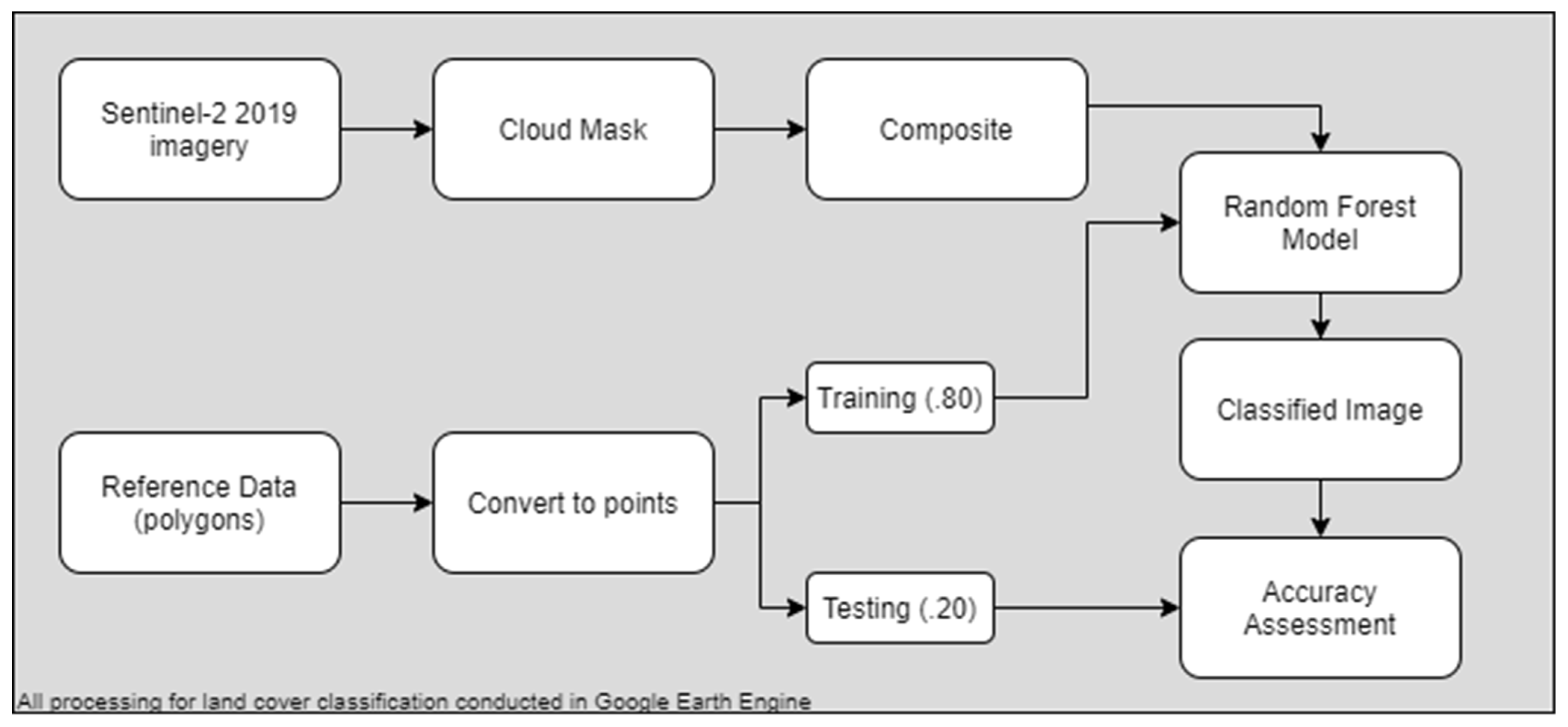
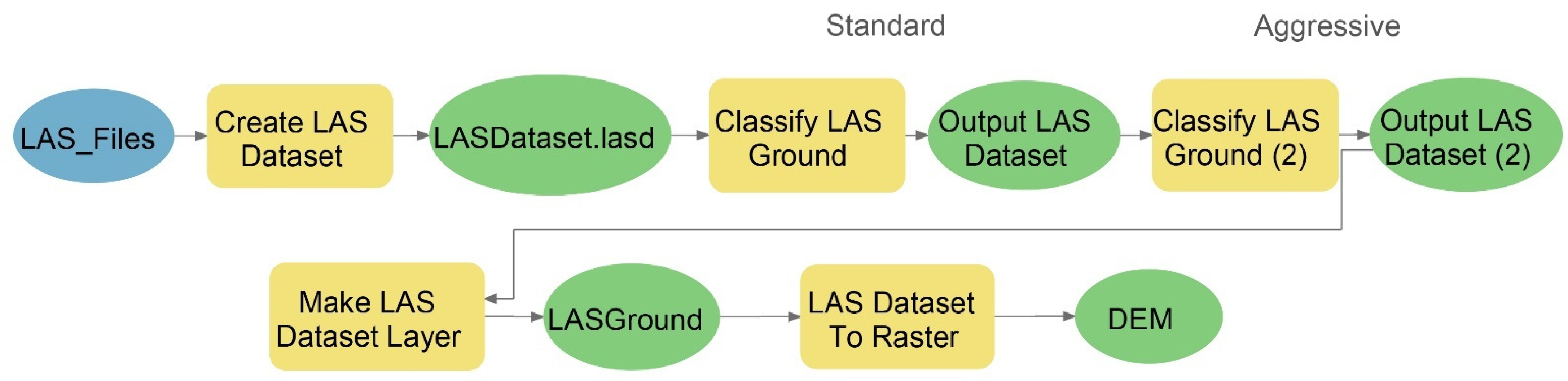
2. Materials and Methods
3. Results
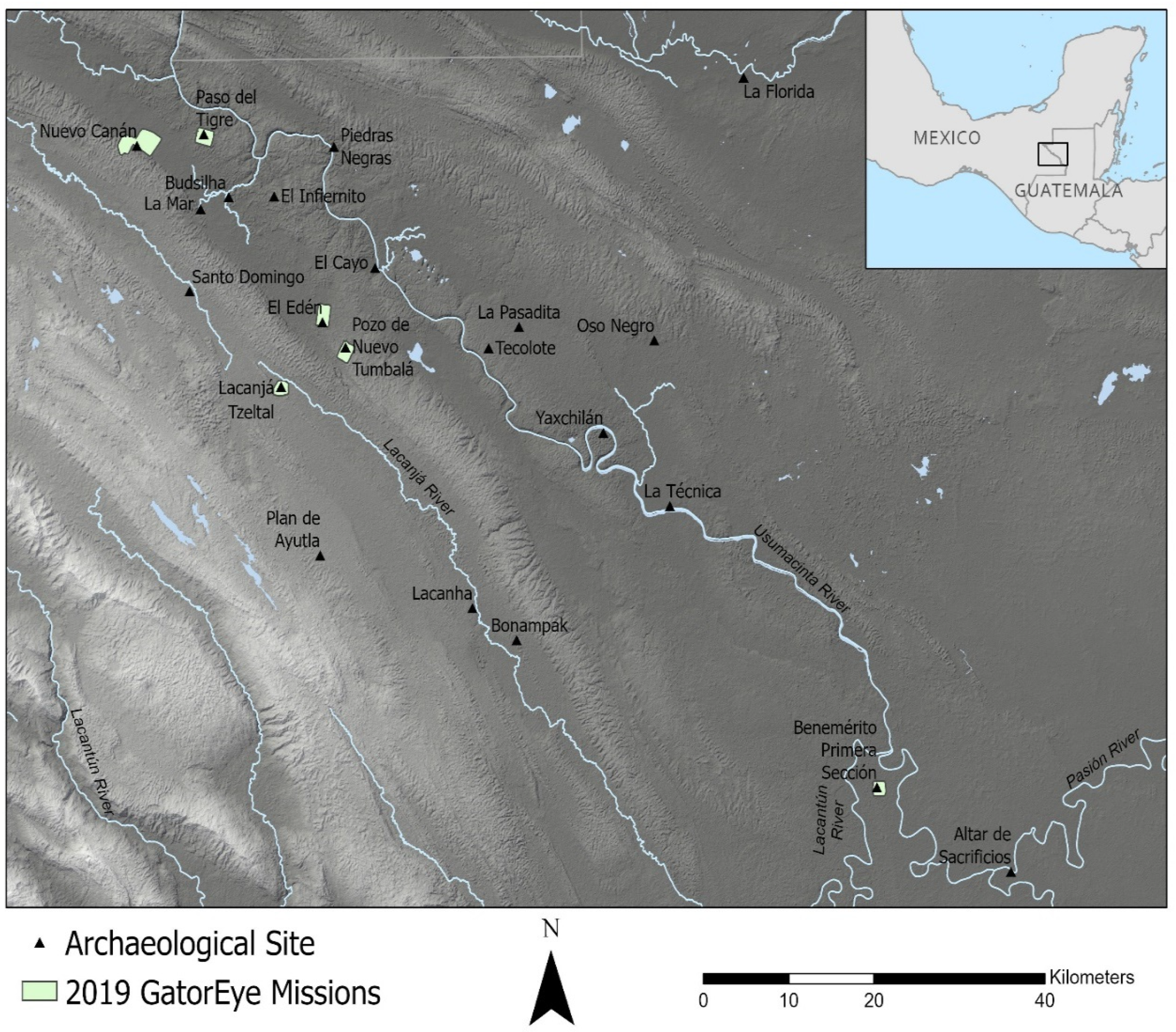
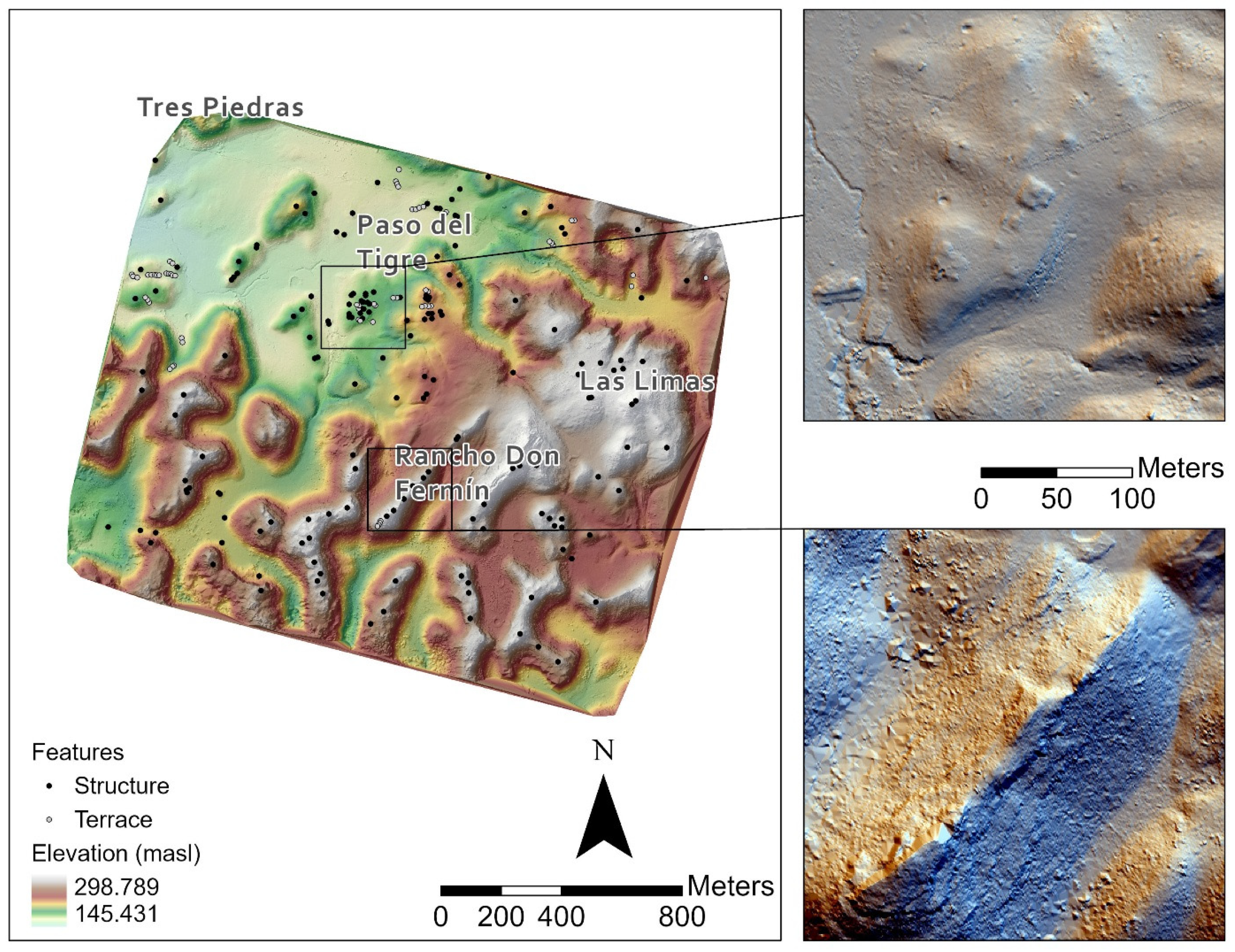
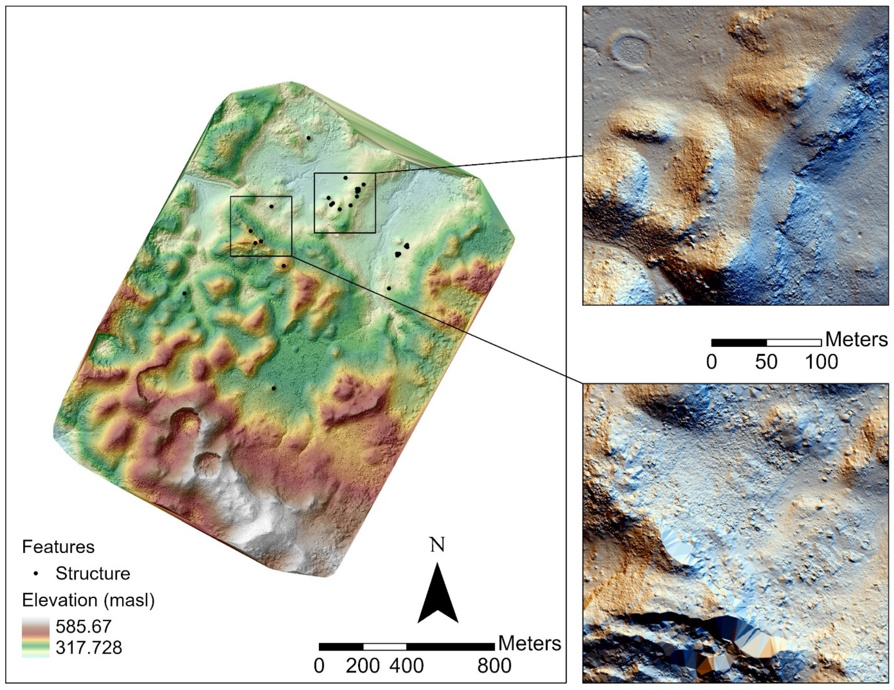
3.1. Paso del Tigre, Las Limas, and Rancho Don Fermín
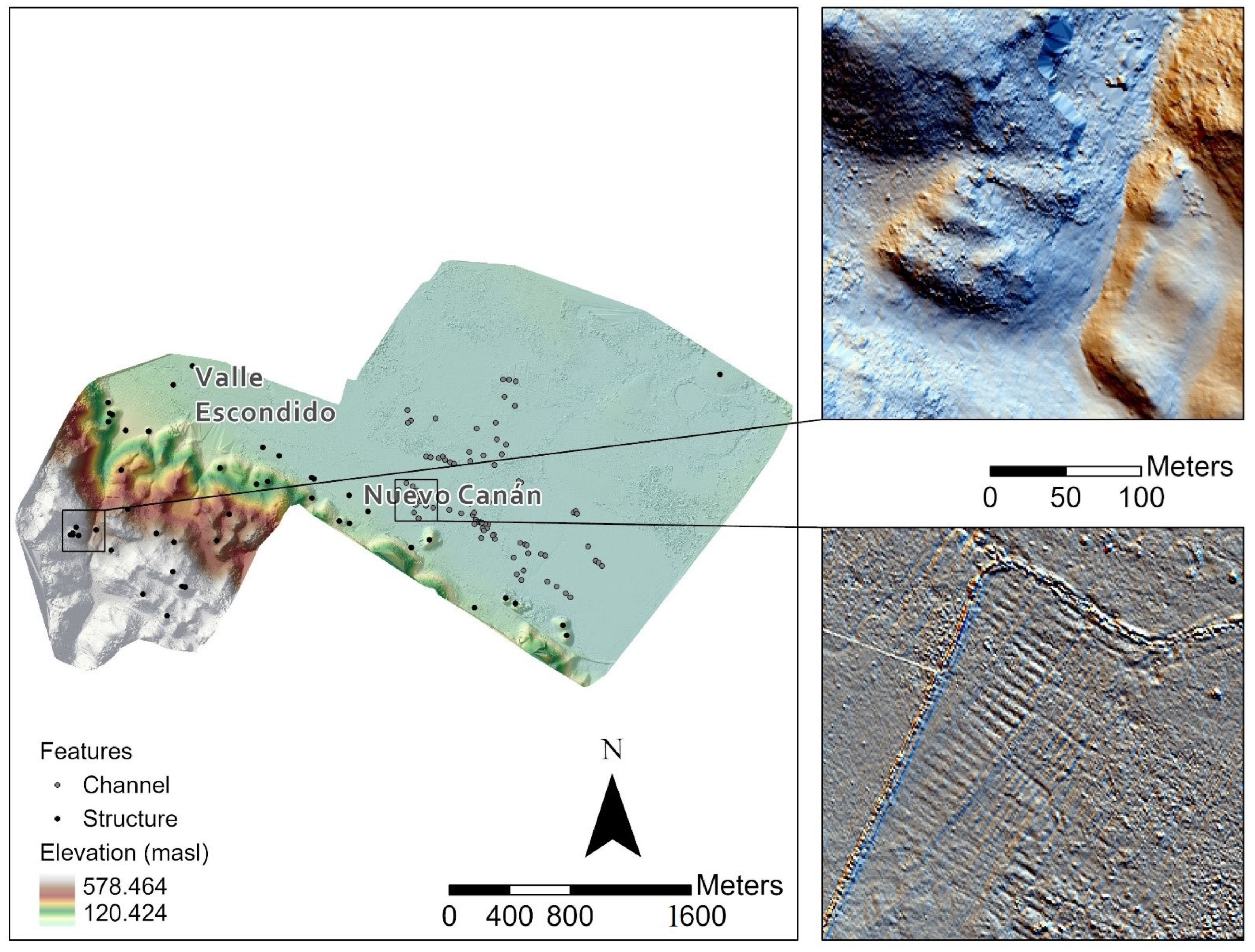
3.2. Nuevo Canán and Valle Escondido
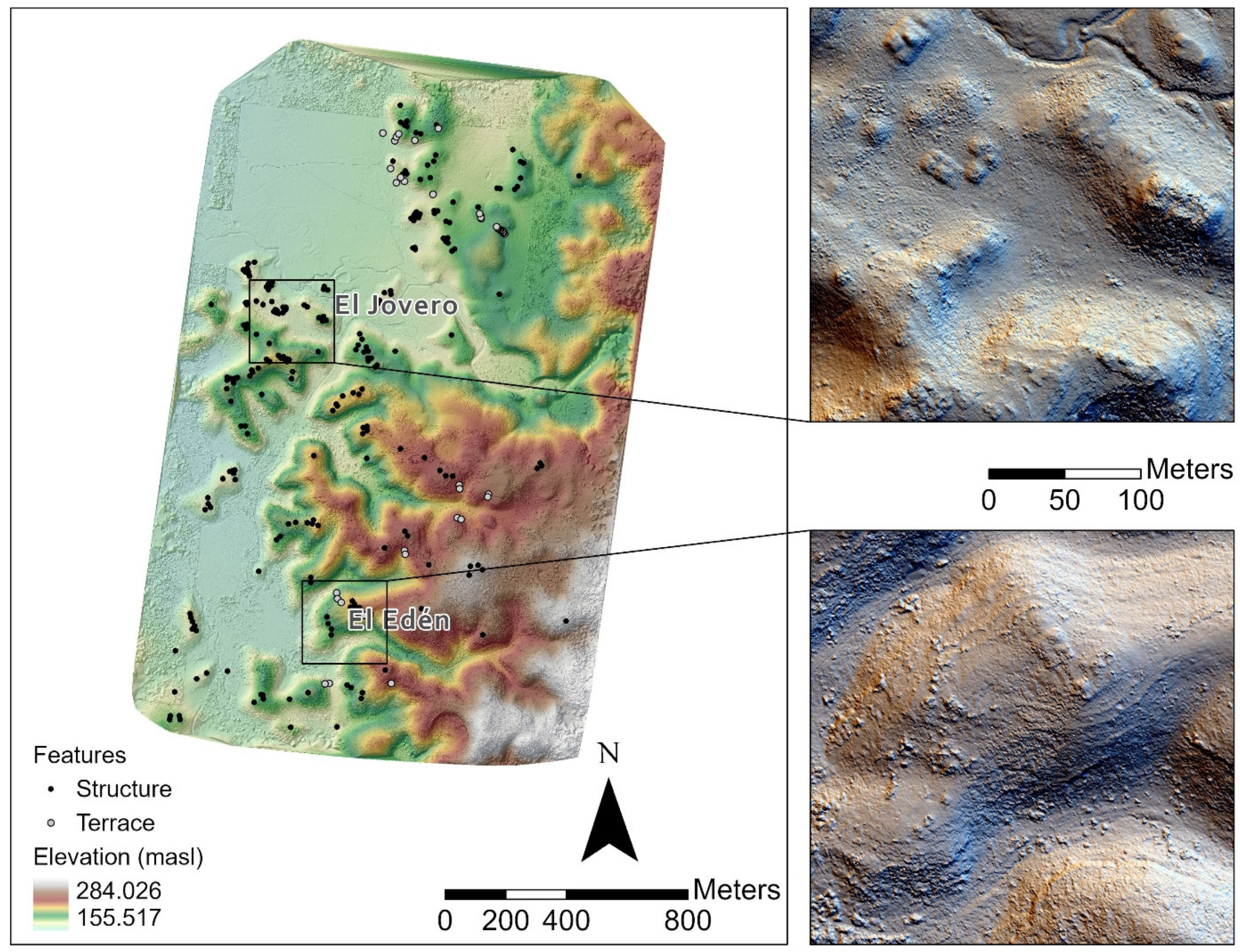
3.3. El Edén and El Jovero
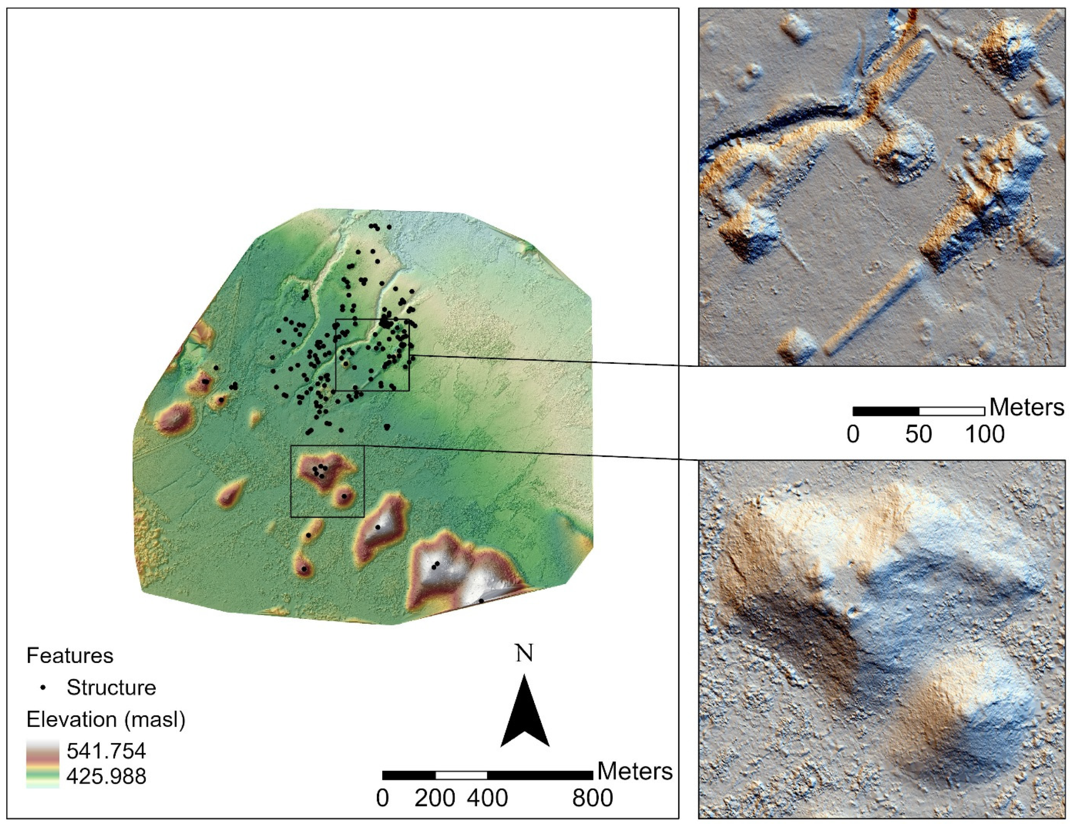
3.4. El Pozo de Nuevo Tumbalá
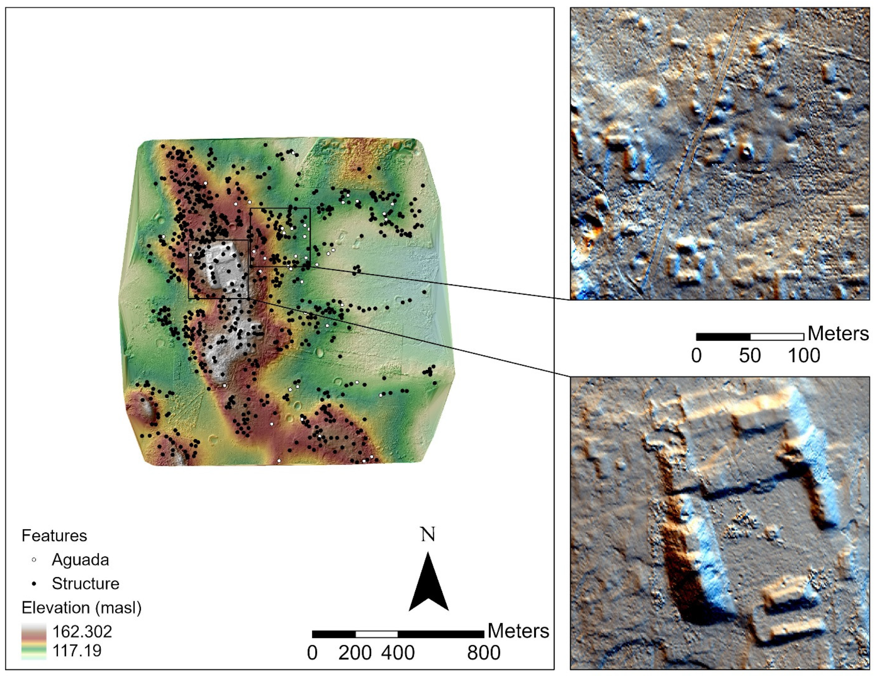
3.5. Lacanjá Tzeltal
3.6. Benemérito de las Américas, Primera Sección
4. Discussion
5. Conclusions
Author Contributions
Funding
Institutional Review Board Statement
Informed Consent Statement
Data Availability Statement
Acknowledgments
Conflicts of Interest
References
- Canuto, M.A.; Estrada-Belli, F.; Garrison, T.G.; Houston, S.D.; Acuña, M.J.; Kováč, M.; Marken, D.; Nondédéo, P.; Auld-Thomas, L.; Castanet, C.; et al. Ancient lowland Maya complexity as revealed by airborne laser scanning of northern Guatemala. Science 2018, 361, eaau0137. [Google Scholar] [CrossRef] [PubMed] [Green Version]
- Chase, A.F.; Chase, D.Z.; Weishampel, J.F.; Drake, J.B.; Shrestha, R.L.; Slatton, K.C.; Awe, J.J.; Carter, W.E. Airborne LiDAR, archaeology, and the ancient Maya landscape at Caracol, Belize. J. Archaeol. Sci. 2011, 38, 387–398. [Google Scholar] [CrossRef]
- Chase, A.F.; Chase, D.Z.; Fisher, C.T.; Leisz, S.J.; Weishampel, J.F. Geospatial revolution and remote sensing LiDAR in Mesoamerican archaeology. Proc. Natl. Acad. Sci. USA 2012, 109, 12916–12921. [Google Scholar] [CrossRef] [PubMed] [Green Version]
- Hutson, S.R. Adapting LiDAR data for regional variation in the tropics: A case study from the Northern Maya Lowlands. J. Archaeol. Sci. Rep. 2015, 4, 252–263. [Google Scholar] [CrossRef] [Green Version]
- Inomata, T.; Triadan, D.; Pinzón, F.; Aoyama, K. Artificial plateau construction during the Preclassic period at the Maya site of Ceibal, Guatemala. PLoS ONE 2019, 14, e0221943. [Google Scholar] [CrossRef] [Green Version]
- Inomata, T.; Triadan, D.; López, V.A.V.; Fernandez-Diaz, J.C.; Omori, T.; Bauer, M.B.M.; Hernández, M.G.; Beach, T.; Cagnato, C.; Aoyama, K.; et al. Monumental architecture at Aguada Fénix and the rise of Maya civilization. Nature 2020, 582, 530–533. [Google Scholar] [CrossRef]
- Inomata, T.; Fernandez-Diaz, J.C.; Triadan, D.; Mollinedo, M.G.; Pinzón, F.; Hernández, M.G.; Flores, A.; Sharpe, A.; Beach, T.; Hodgins, G.W.L.; et al. Origins and spread of formal ceremonial complexes in the Olmec and Maya regions revealed by airborne lidar. Nat. Hum. Behav. 2021, 5, 1487–1501. [Google Scholar] [CrossRef]
- Ringle, W.M.; Negrón, T.G.; Ciau, R.M.; Seligson, K.E.; Fernandez-Diaz, J.C.; Zapata, D.O. Lidar survey of ancient Maya settlement in the Puuc region of Yucatan, Mexico. PLoS ONE 2021, 16, e0249314. [Google Scholar] [CrossRef]
- Rosenswig, R.M.; López-Torrijos, R.; Antonelli, C.E.; Mendelsohn, R.R. Lidar mapping and surface survey of the Izapa state on the tropical piedmont of Chiapas, Mexico. J. Archaeol. Sci. 2013, 40, 1493–1507. [Google Scholar] [CrossRef]
- Canuto, M.A.; Auld-Thomas, L. Taking the high ground: A model for lowland Maya settlement patterns. J. Anthr. Archaeol. 2021, 64, 101349. [Google Scholar] [CrossRef]
- Chase, A.F.; Chase, D.Z.; Weishampel, J.F. Lasers in the Jungle. Archaeology 2010, 63, 27–29. [Google Scholar]
- Schroder, W.; Murtha, T.; Golden, C.; Hernández, A.A.; Scherer, A.; Morell-Hart, S.; Almeida Zambrano, A.; Broadbent, E.; Brown, M. The lowland Maya settlement landscape: Environmental LiDAR and ecology. J. Archaeol. Sci. Rep. 2020, 33, 102543. [Google Scholar] [CrossRef]
- Chase, A.; Weishampel, J. Using Lidar and GIS to Investigate Water and Soil Management in the Agricultural Terracing at Caracol, Belize. Adv. Archaeol. Pract. 2016, 4, 357–370. [Google Scholar] [CrossRef]
- Inomata, T.; Pinzón, F.; Ranchos, J.L.; Haraguchi, T.; Nasu, H.; Fernandez-Diaz, J.C.; Aoyama, K.; Yonenobu, H. Archaeological Application of Airborne LiDAR with Object-Based Vegetation Classification and Visualization Techniques at the Lowland Maya Site of Ceibal, Guatemala. Remote Sens. 2017, 9, 563. [Google Scholar] [CrossRef] [Green Version]
- Inomata, T.; Triadan, D.; Pinzón, F.; Burham, M.; Ranchos, J.L.; Aoyama, K.; Haraguchi, T. Archaeological application of airborne LiDAR to examine social changes in the Ceibal region of the Maya lowlands. PLoS ONE 2018, 13, e0191619. [Google Scholar] [CrossRef]
- Weishampel, J.F.; Chase, A.F.; Chase, D.Z.; Drake, J.B.; Shrestha, R.L.; Slatton, K.C.; Awe, J.J.; Hightower, J.; Angelo, J. Remote sensing of ancient Maya land use features at Caracol, Belize related to tropical rainforest structure. In Space, Time, Place: Third International Conference on Remote Sensing Archaeology; Forte, M., Campana, S., Liuzza, C., Eds.; British Archaeological Reports S2118: Oxford, UK, 2010; Volume 2118, pp. 45–52. [Google Scholar]
- Doneus, M.; Briese, C. Full-Waveform Airborne Laser Scanning as a Tool for Archaeological Reconnaissance. In From Space to Place: 2nd International Conference on Remote Sensing in Archaeology, Proceedings of the 2nd International Workshop, CNR, Rome, Italy, 4–7 December 2006; Campana, S., Forte, M., Eds.; BAR Publishing: Oxford, UK, 2006; pp. 99–105. [Google Scholar]
- Doneus, M.; Briese, C.; Fera, M.; Janner, M. Archaeological prospection of forested areas using full-waveform airborne laser scanning. J. Archaeol. Sci. 2008, 35, 882–893. [Google Scholar] [CrossRef]
- Corte, A.P.D.; Rex, F.E.; de Almeida, D.R.A.; Sanquetta, C.R.; Silva, C.A.; Moura, M.M.; Wilkinson, B.; Zambrano, A.M.A.; da Cunha Neto, E.M.; Veras, H.F.P.; et al. Measuring Individual Tree Diameter and Height Using GatorEye High-Density UAV-Lidar in an Integrated Crop-Livestock-Forest System. Remote Sens. 2020, 12, 863. [Google Scholar] [CrossRef] [Green Version]
- Corte, A.P.D.; Souza, D.V.; Rex, F.E.; Sanquetta, C.R.; Mohan, M.; Silva, C.A.; Zambrano, A.M.A.; Prata, G.; de Almeida, D.R.A.; Trautenmüller, J.W.; et al. Forest inventory with high-density UAV-Lidar: Machine learning approaches for predicting individual tree attributes. Comput. Electron. Agric. 2020, 179, 105815. [Google Scholar] [CrossRef]
- Kellner, J.R.; Armston, J.; Birrer, M.; Cushman, K.C.; Duncanson, L.; Eck, C.; Falleger, C.; Imbach, B.; Král, K.; Krůček, M.; et al. New Opportunities for Forest Remote Sensing Through Ultra-High-Density Drone Lidar. Surv. Geophys. 2019, 40, 959–977. [Google Scholar] [CrossRef] [Green Version]
- Lin, Y.-C.; Cheng, Y.-T.; Zhou, T.; Ravi, R.; Hasheminasab, S.M.; Flatt, J.E.; Troy, C.; Habib, A. Evaluation of UAV LiDAR for Mapping Coastal Environments. Remote Sens. 2019, 11, 2893. [Google Scholar] [CrossRef] [Green Version]
- Prata, G.; Broadbent, E.; De Almeida, D.; Peter, J.; Drake, J.; Medley, P.; Corte, A.; Vogel, J.; Sharma, A.; Silva, C.; et al. Single-Pass UAV-Borne GatorEye LiDAR Sampling as a Rapid Assessment Method for Surveying Forest Structure. Remote Sens. 2020, 12, 4111. [Google Scholar] [CrossRef]
- Resop, J.P.; Lehmann, L.; Hession, W.C. Drone Laser Scanning for Modeling Riverscape Topography and Vegetation: Comparison with Traditional Aerial Lidar. Drones 2019, 3, 35. [Google Scholar] [CrossRef] [Green Version]
- Sofonia, J.J.; Phinn, S.; Roelfsema, C.; Kendoul, F.; Rist, Y. Modelling the effects of fundamental UAV flight parameters on LiDAR point clouds to facilitate objectives-based planning. ISPRS J. Photogramm. Remote Sens. 2019, 149, 105–118. [Google Scholar] [CrossRef]
- Wallace, L.; Lucieer, A.; Watson, C.; Turner, D. Development of a UAV-LiDAR System with Application to Forest Inventory. Remote Sens. 2012, 4, 1519–1543. [Google Scholar] [CrossRef] [Green Version]
- Bikoulis, P.; Gonzalez-Macqueen, F.; Spence-Morrow, G.; Álvarez, W.Y.; Bautista, S.; Jennings, J. A new methodology for geoglyph research: Preliminary survey results and practical workflow from the Quilcapampa Geoglyph Survey (Sihuas Valley, Peru). J. Archaeol. Sci. Rep. 2016, 10, 119–129. [Google Scholar] [CrossRef]
- Chiabrando, F.; D’Andria, F.; Sammartano, G.; Spanò, A. UAV photogrammetry for archaeological site survey. 3D models at the Hierapolis in Phrygia (Turkey). Virtual Archaeol. Rev. 2018, 9, 28–43. [Google Scholar] [CrossRef] [Green Version]
- Field, S.; Waite, M.; Wandsnider, L. The utility of UAVs for archaeological surface survey: A comparative study. J. Archaeol. Sci. Rep. 2017, 13, 577–582. [Google Scholar] [CrossRef]
- Hill, A.C. Economical drone mapping for archaeology: Comparisons of efficiency and accuracy. J. Archaeol. Sci. Rep. 2019, 24, 80–91. [Google Scholar] [CrossRef]
- Kadhim, I.; Abed, F.M. The Potential of LiDAR and UAV-Photogrammetric Data Analysis to Interpret Archaeological Sites: A Case Study of Chun Castle in South-West England. ISPRS Int. J. Geo-Inf. 2021, 10, 41. [Google Scholar] [CrossRef]
- Magnani, M.; Douglass, M.; Schroder, W.; Reeves, J.; Braun, D.R. The Digital Revolution to Come: Photogrammetry in Archaeological Practice. Am. Antiq. 2020, 85, 737–760. [Google Scholar] [CrossRef]
- Marín-Buzón, C.; Pérez-Romero, A.; López-Castro, J.; Ben Jerbania, I.; Manzano-Agugliaro, F. Photogrammetry as a New Scientific Tool in Archaeology: Worldwide Research Trends. Sustainability 2021, 13, 5319. [Google Scholar] [CrossRef]
- Nikolakopoulos, K.G.; Soura, K.; Koukouvelas, I.K.; Argyropoulos, N.G. UAV vs. classical aerial photogrammetry for archaeological studies. J. Archaeol. Sci. Rep. 2017, 14, 758–773. [Google Scholar] [CrossRef]
- Olson, K.G.; Rouse, L.M. A Beginner′s Guide to Mesoscale Survey with Quadrotor-UAV Systems. Adv. Archaeol. Pract. 2018, 6, 357–371. [Google Scholar] [CrossRef]
- Rouse, L.M.; Krumnow, J. On the fly: Strategies for UAV-based archaeological survey in mountainous areas of Central Asia and their implications for landscape research. J. Archaeol. Sci. Rep. 2020, 30, 102275. [Google Scholar] [CrossRef]
- Carmona, J.S.; Quirós, E.; Mayoral, V.; Charro, C. Assessing the potential of multispectral and thermal UAV imagery from archaeological sites. A case study from the Iron Age hillfort of Villasviejas del Tamuja (Cáceres, Spain). J. Archaeol. Sci. Rep. 2020, 31, 102312. [Google Scholar] [CrossRef]
- Schroder, W.; Golden, C.; Scherer, A.; Murtha, T.; Firpi, O. Remote Sensing and Reconnaissance along the Lacantún River: The Lakamtuun Dynasty and the Sites of El Palma and Benemérito de Las Américas, Primera Sección. Mexicon 2019, 41, 157–167. [Google Scholar]
- Vilbig, J.M.; Sagan, V.; Bodine, C. Archaeological surveying with airborne LiDAR and UAV photogrammetry: A comparative analysis at Cahokia Mounds. J. Archaeol. Sci. Rep. 2020, 33, 102509. [Google Scholar] [CrossRef]
- Barbour, T.E.; Sassaman, K.E.; Zambrano, A.M.A.; Broadbent, E.N.; Wilkinson, B.; Kanaski, R. Rare pre-Columbian settlement on the Florida Gulf Coast revealed through high-resolution drone LiDAR. Proc. Natl. Acad. Sci. USA 2019, 116, 23493–23498. [Google Scholar] [CrossRef]
- Poirier, N.; Baleux, F.; Calastrenc, C. The Mapping of Forested Archaeological Sites Using UAV LiDaR. A Feedback from a South-West France Experiment in Settlement & Landscape Archaeology. Digit. Archaeol. 2020, 4, 1–24. [Google Scholar] [CrossRef]
- Ćmielewski, B.; Sieczkowska, D.; Kościuk, J.; Bastante, J.M.; Wilczyńska, I. UAV LiDAR Mapping in the Historic Sanctuary of Machupicchu: Challenges and Preliminary Results: Part 1. Wiadomości Konserwatorskie. J. Herit. Conserv. 2021, 67, 159–170. [Google Scholar] [CrossRef]
- McCoy, M.D.; Casana, J.; Hill, A.C.; Laugier, E.J.; Mulrooney, M.A.; Ladefoged, T.N. Unpiloted Aerial Vehicle Acquired Lidar for Mapping Monumental Architecture: A Case Study from the Hawaiian Islands. Adv. Archaeol. Pract. 2021, 9, 160–174. [Google Scholar] [CrossRef]
- Murtha, T.M.; Broadbent, E.N.; Golden, C.; Scherer, A.; Schroder, W.; Wilkinson, B.; Zambrano, A.A. Drone-Mounted Lidar Survey of Maya Settlement and Landscape. Lat. Am. Antiq. 2019, 30, 630–636. [Google Scholar] [CrossRef] [Green Version]
- Risbøl, O.; Gustavsen, L. LiDAR from drones employed for mapping archaeology—Potential, benefits and challenges. Archaeol. Prospect. 2018, 25, 329–338. [Google Scholar] [CrossRef]
- Schroder, W.; Murtha, T.; Broadbent, E.N.; Zambrano, A.M.A. A confluence of communities: Households and land use at the junction of the Upper Usumacinta and Lacantún Rivers, Chiapas, Mexico. World Archaeol. 2021, 1–28. [Google Scholar] [CrossRef]
- Van Valkenburgh, P.; Cushman, K.C.; Castillo Butters, L.J.; Rojas Vega, C.; Roberts, C.; Kepler, C.; Kellner, J. Lasers Without Lost Cities: Using Drone Lidar to Capture Architectural Complexity at Kuelap, Amazonas, Peru. J. Field Archaeol. 2020, 45, S75–S88. [Google Scholar] [CrossRef] [Green Version]
- Comer, D.C.; Comer, J.A.; Dumitru, I.A.; Ayres, W.S.; Levin, M.J.; Seikel, K.A.; White, D.A.; Harrower, M.J. Airborne LiDAR Reveals a Vast Archaeological Landscape at the Nan Madol World Heritage Site. Remote Sens. 2019, 11, 2152. [Google Scholar] [CrossRef] [Green Version]
- Evans, D.H.; Fletcher, R.J.; Pottier, C.; Chevance, J.-B.; Soutif, D.; Tan, B.S.; Im, S.; Ea, D.; Tin, T.; Kim, S.; et al. Uncovering archaeological landscapes at Angkor using lidar. Proc. Natl. Acad. Sci. USA 2013, 110, 12595–12600. [Google Scholar] [CrossRef] [Green Version]
- Evans, D.; Fletcher, R. The landscape of Angkor Wat redefined. Antiquity 2015, 89, 1402–1419. [Google Scholar] [CrossRef]
- Fernandez-Diaz, J.C.; Carter, W.E.; Shrestha, R.L.; Glennie, C.L. Now You See It… Now You Don’t: Understanding Airborne Mapping LiDAR Collection and Data Product Generation for Archaeological Research in Mesoamerica. Remote Sens. 2014, 6, 9951–10001. [Google Scholar] [CrossRef] [Green Version]
- Fisher, C.T.; Fernández-Diaz, J.C.; Cohen, A.S.; Cruz, O.N.; Gonzáles, A.M.; Leisz, S.J.; Pezzutti, F.; Shrestha, R.; Carter, W. Identifying Ancient Settlement Patterns through LiDAR in the Mosquitia Region of Honduras. PLoS ONE 2016, 11, e0159890. [Google Scholar] [CrossRef]
- Iriarte, J.; Robinson, M.; De Souza, J.; Damasceno, A.; Da Silva, F.; Nakahara, F.; Ranzi, A.; Aragao, L. Geometry by Design: Contribution of Lidar to the Understanding of Settlement Patterns of the Mound Villages in SW Amazonia. J. Comput. Appl. Archaeol. 2020, 3, 151–169. [Google Scholar] [CrossRef]
- Campana, S. Drones in Archaeology. State-of-the-art and Future Perspectives. Archaeol. Prospect. 2017, 24, 275–296. [Google Scholar] [CrossRef]
- Forte, M.; Campana, S. (Eds.) Digital Methods and Remote Sensing in Archaeology: Archaeology in the Age of Sensing; Springer: Cham, Switzerland, 2017. [Google Scholar]
- Palka, J.W.; Sánchez Balderas, F.; Hollingshead, I.; Balsanelli, A.; Hernández, C.; Juárez, S.; Lozada Toledo, J.; McGee, R.J.; Salgado-Flores, S. Long-Term Collaborative Research with Lacandon Maya at Mensäbäk, Chiapas, Mexico. In The Mayanist; American Foreign Academic Research: Davidson, NC, USA, 2020; Volume 2, pp. 1–20. [Google Scholar]
- Davis, D.S.; Buffa, D.; Rasolondrainy, T.; Creswell, E.; Anyanwu, C.; Ibirogba, A.; Randolph, C.; Ouarghidi, A.; Phelps, L.N.; Lahiniriko, F.; et al. The aerial panopticon and the ethics of archaeological remote sensing in sacred cultural spaces. Archaeol. Prospect. 2021, 28, 305–320. [Google Scholar] [CrossRef]
- Golden, C.; Scherer, A.K.; Schroder, W.; Murtha, T.; Morell-Hart, S.; Diaz, J.C.F.; Álvarez, S.D.P.J.; Firpi, O.A.; Agostini, M.; Bazarsky, A.; et al. Airborne Lidar Survey, Density-Based Clustering, and Ancient Maya Settlement in the Upper Usumacinta River Region of Mexico and Guatemala. Remote Sens. 2021, 13, 4109. [Google Scholar] [CrossRef]
- Golden, C.; Scherer, A.K. Territory, Trust, Growth, and Collapse in Classic Period Maya Kingdoms. Curr. Anthr. 2013, 54, 397–435. [Google Scholar] [CrossRef]
- Scherer, A.; Golden, C. Revisiting Maler′s Usumacinta: Recent Archaeological Investigations in Chiapas, Mexico; Precolumbia Mesoweb Press: San Francisco, CA, USA, 2012. [Google Scholar]
- Aliphat Fernández, M.M. Classic Maya Landscape in the Upper Usumacinta River Valley. Ph.D. Dissertation, University of Calgary, Calgary, AB, Canada, 1994. [Google Scholar]
- Anaya Hernández, A. Site Interaction and Political Geography in the Upper Usumacinta Region. during the Late Classic: A GIS Approach; BAR International Series 994; J. and E. Hedges: Oxford, UK, 2001. [Google Scholar]
- Rands, R.L. The Classic Maya collapse: Usumacinta zone and the northwestern periphery. In The Classic Maya collapse; Culbert, T.P., Ed.; University of New Mexico Press: Albuquerque, NM, USA, 1973; pp. 165–206. [Google Scholar]
- Golden, C.; Scherer, A.K. Border Problems: Recent Archaeological Research along the Usumacinta River. PARI J. 2006, 7, 1–16. [Google Scholar]
- Golden, C.; Scherer, A.K.; Muñoz, A.R.; Vasquez, R. Piedras Negras and Yaxchilan: Divergent Political Trajectories in Adjacent Maya Polities. Lat. Am. Antiq. 2008, 19, 249–274. [Google Scholar] [CrossRef]
- Gorelick, N.; Hancher, M.; Dixon, M.; Ilyushchenko, S.; Thau, D.; Moore, R. Google Earth Engine: Planetary-scale geospatial analysis for everyone. Remote Sens. Environ. 2017, 202, 18–27. [Google Scholar] [CrossRef]
- Louis, J. L2A team Sentinel 2, S2 MPC, Leven-2A Algorithm Theoretical Basis Document. Available online: https://sentinel.esa.int/documents/247904/446933/Sentinel-2-Level-2A-Algorithm-Theoretical-Basis-Document-ATBD.pdf/fe5bacb4-7d4c-9212-8606-6591384390c3?t=1618563205231 (accessed on 26 October 2021).
- Olofsson, P.; Foody, G.M.; Herold, M.; Stehman, S.V.; Woodcock, C.E.; Wulder, M.A. Good practices for estimating area and assessing accuracy of land change. Remote Sens. Environ. 2014, 148, 42–57. [Google Scholar] [CrossRef]
- Golden, C.; Munkvold, I.; Girardi, S. Estudio preliminar por LiDAR en Piedras Negras. In Proyecto Paisaje Piedras Negras-Yaxchilán: Informe de la Segunda Temporada de Investigación Presentado ante el Instituto de Antropología e Historia; Urquizú, M., Scherer, A.K., Golden, C., Eds.; Instituto de Antropología e Historia: Guatemala City, Guatemala, 2017; pp. 157–163. [Google Scholar]
- Golden, C.; Murtha, T.; Cook, B.; Shaffer, D.S.; Schroder, W.; Hermitt, E.J.; Firpi, O.A.A.; Scherer, A.K. Reanalyzing environmental lidar data for archaeology: Mesoamerican applications and implications. J. Archaeol. Sci. Rep. 2016, 9, 293–308. [Google Scholar] [CrossRef] [Green Version]
- Murtha, T.; Broadbent, E.N.; Fernández-Diaz, J.C.; Golden, C.; Scherer, A.K. Aplicaciones de sistemas de lidar mediante vehículo aéreo no tripulado y avión. In Proyecto Arqueológico Busiljá-Chocoljá: Informe de la décima temporada de investigación presentado ante el Consejo de Arqueología del Instituto Nacional de Antropología e Historia; Scherer, A.K., Golden, C., Eds.; Instituto Nacional de Antropología e Historia: Mexico City, Mexico, 2019; pp. 346–351. [Google Scholar]
- Klápště, P.; Fogl, M.; Barták, V.; Gdulová, K.; Urban, R.; Moudrý, V. Sensitivity analysis of parameters and contrasting performance of ground filtering algorithms with UAV photogrammetry-based and LiDAR point clouds. Int. J. Digit. Earth 2020, 13, 1672–1694. [Google Scholar] [CrossRef]
- Kokalj, Ž.; Hesse, R. Airborne Laser Scanning Raster Data Visualization: A Guide to Good Practice; Založba ZRC: Ljubljana, Slovenia, 2017. [Google Scholar]
- Lozić, E.; Štular, B. Documentation of Archaeology-Specific Workflow for Airborne LiDAR Data Processing. Geosciences 2021, 11, 26. [Google Scholar] [CrossRef]
- Štular, B.; Lozić, E. Comparison of Filters for Archaeology-Specific Ground Extraction from Airborne LiDAR Point Clouds. Remote Sens. 2020, 12, 3025. [Google Scholar] [CrossRef]
- Štular, B.; Eichert, S.; Lozić, E. Airborne LiDAR Point Cloud Processing for Archaeology. Pipeline and QGIS Toolbox. Remote Sens. 2021, 13, 3225. [Google Scholar] [CrossRef]
- Guzmán-López, P. Reconocimiento arqueológico en los alrededores de La Mar. In Proyecto Arqueológico Busiljá-Chocoljá: Informe de la Cuarta Temporada de Investigación Presentado ante el Consejo de Arqueología del Instituto Nacional de Antropología e Historia; Scherer, A.K., Golden, C., Dobereiner, J., Eds.; Instituto Nacional de Antropología e Historia: Mexico City, Mexico, 2013; pp. 120–141. [Google Scholar]
- Schroder, W. Reconocimiento arqueológico en los ranchos Santa Marta y Tres Piedras, Nueva Esperanza Progresista. In Proyecto Arqueológico Busiljá-Chocoljá: Informe de la Sexta Temporada de Investigación Presentado ante el Consejo de Arqueología del Instituto Nacional de Antropología e Historia; Schroder, W., Golden, C., Scherer, A.K., Eds.; Instituto Nacional de Antropología e Historia: Mexico City, Mexico, 2015; pp. 99–110. [Google Scholar]
- Schroder, W. Reconocimiento en Arroyo Belén, La Selva, Busiljá, Nuevo Guerrero, Nuevo Jerusalén, Nuevo Pedregal, y Ojo de Agua Zapote. In Proyecto Arqueológico Busiljá-Chocoljá: Informe de la Novena Temporada de Investigación Presentado ante el Consejo de Arqueología del Instituto Nacional de Antropología e Historia; Scherer, A.K., Golden, C., Eds.; Instituto Nacional de Antropología e Historia: Mexico City, Mexico, 2018; pp. 200–220. [Google Scholar]
- del Pilar, S.J.A.; Sobrino Fernández, S.A.; Ojeda González, S.; Borges Barrientos, J.L. Descripciones de las cerámicas procedentes de los sitios arqueológicos Lacanjá Tzeltal, Rancho Poniente, y Sacrificios, Chiapas. In Proyecto Arqueológico Busiljá-Chocoljá: Informe de la Novena Temporada de Investigación Presentado ante el Consejo de Arqueología e Historia; Scherer, A.K., Golden, C., Eds.; Instituto Nacional de Antropología e Historia: Mexico City, Mexico, 2018; pp. 300–311. [Google Scholar]
- del Pilar, S.J.A.; Sobrino Fernández, S.A.; Ojeda González, S.; Borges Barrientos, J.L. Tipología de las cerámicas de los sitios arqueológicos Lacanjá Tzeltal, Rancho Poniente y Sacrificios, Chiapas. In Proyecto Arqueológico Busiljá-Chocoljá: Informe de la Novena Temporada de Investigación Presentado ante el Consejo de Arqueología del Instituto Nacional de Antropología e Historia; Scherer, A.K., Golden, C., Eds.; Instituto Nacional de Antropología e Historia: Mexico City, Mexico, 2018; pp. 312–345. [Google Scholar]
- Ramiro Talavera, M.Y.; Ojeda González, S.; Schnell, J. Las Limas: Investigaciones preliminares. In Proyecto Arqueológico Busiljá-Chocoljá: Informe de la Décima Temporada de Investigación Presentado ante el Consejo de Arqueología del Instituto Nacional de Antropología e Historia; Scherer, A.K., Golden, C., Eds.; Instituto Nacional de Antropología e Historia: Mexico City, Mexico, 2019; pp. 302–321. [Google Scholar]
- Seidita, M.; Ojeda González, S.; Kollias, G.V., III; Talavera, M. Reconocimiento en Ricardo Flores Magón y el Ejido de Sacrificio. In Proyecto Arqueológico Busiljá-Chocoljá: Informe de la Novena Temporada de Investigación Presentado ante el Consejo de Arqueología del Instituto Nacional de Antropología e Historia; Scherer, A.K., Golden, C., Eds.; Instituto Nacional de Antropología e Historia: Mexico City, Mexico, 2018; pp. 110–152. [Google Scholar]
- Alcover Firpi, O. Conflict, Defense, and Cooperation at Macabilero, Peten, Guatemala. Ph.D. Dissertation, Brown University, Providence, RI, USA, 2020. [Google Scholar]
- Schroder, W. Community Resilience through Crisis at El Infiernito, Chiapas, a Fortified Refuge in the Upper Usumacinta Valley. Ph.D. Dissertation, University of Pennsylvania, Philadelphia, PA, USA, 2019. [Google Scholar]
- Schroder, W. Cycles of defence on the Piedras Negras kingdom periphery: Landscape patrimony at the fortified hilltop community of El Infiernito, Chiapas. Landsc. Res. 2021, 46, 793–810. [Google Scholar] [CrossRef]
- Davenport, B.; Guzmán-López, P.; Delgado Arévalo, J.H. Vallescondido: Investigaciones preliminares. In Proyecto Arqueológico Busiljá-Chocoljá: Informe de la Tercera Temporada de Campo Presentado ante el Consejo de Arqueología del Instituto Nacional de Antropología e Historia; Scherer, A.K., Golden, C., Dobereiner, J., Eds.; Instituto Nacional de Antropología e Historia: Mexico City, Mexico, 2012; pp. 167–169. [Google Scholar]
- Golden, C.; Morell-Hart, S.; Murtha, T.; Scherer, A.K.; Broadbent, E.N.; Schroder, W.; Bérubé, É.; Dine, H. Campos canalizados en el Ejido de Nuevo Canán, Palenque. In Proyecto Arqueológico Busiljá-Chocoljá: Informe de la Décima Temporada de Investigación Presentado ante el Consejo de Arqueología del Instituto Nacional de Antropología e Historia; Scherer, A.K., Golden, C., Eds.; Instituto Nacional de Antropología e Historia: Mexico City, Mexico, 2019; pp. 341–345. [Google Scholar]
- Golden, C.; Scherer, A.K. Rancho El Edén, Nuevo Guerrero y Nuevo Francisco León. In Proyecto Arqueológico Busiljá-Chocoljá: Informe de la Segunda Temporada de Investigación Presentado ante el Consejo de Arqueología del Instituto Nacional de Antropología e Historia; Golden, C., Scherer, A.K., Eds.; Instituto Nacional de Antropología e Historia: Mexico City, Mexico, 2011; pp. 71–77. [Google Scholar]
- Schroder, W. Reconocimiento arqueológico en los alrededores de Nuevo Guerrero, Ocosingo. In Proyecto Arqueológico Busiljá-Chocoljá: Informe de la Sexta Temporada de Investigación Presentado ante el Consejo de Arqueología del Instituto Nacional de Antropología e Historia; Schroder, W., Golden, C., Scherer, A.K., Eds.; Instituto Nacional de Antropología e Historia: Mexico City, Mexico, 2015; pp. 111–121. [Google Scholar]
- Schroder, W.; Golden, C.W.; Scherer, A.K.; Jiménez Álvarez, S.; Del, P.; Dobereiner, J.; Méndez Cab, A. At the Crossroads of Kingdoms: Recent Investigations on the Periphery of Piedras Negras and Its Neighbors. PARI J. 2017, 17, 1–15. [Google Scholar]
- Schroder, W. Reconocimiento arqueológico en Nuevo Francisco León y Nuevo Guerrero, Ocosingo. In Proyecto Arqueológico Busiljá-Chocoljá: Informe de la Séptima Temporada de Investigación Presentado ante el Consejo de Arqueología del Instituto Nacional de Antropología e Historia; Schroder, W., Golden, C., Scherer, A.K., Eds.; Instituto Nacional de Antropología e Historia: Mexico City, Mexico, 2016; pp. 110–127. [Google Scholar]
- Scherer, A.K.; Golden, C. Water in the west: Chronology and collapse of the Western Maya river kingdoms. In The Great Maya Droughts in Cultural Context; Iannone, G., Ed.; University Press of Colorado: Boulder, CO, USA, 2014; pp. 207–229. [Google Scholar]
- Dine, H.; Ramiro Talavera, M.Y.; Bérubé, É.; Scherer, A. El Pozo de Nuevo Tumbalá: Investigaciones preliminares. In Proyecto Arqueológico Busiljá-Chocoljá: Informe de la Décima Temporada de Investigación Presentado ante el Consejo de Arqueología del Instituto Nacional de Antropología e Historia; Scherer, A.K., Golden, C., Eds.; Instituto Nacional de Antropología e Historia: Mexico City, Mexic, 2019; pp. 260–301. [Google Scholar]
- Anaya Hernández, A.; Guenter, S.; Zender, M. Sak Tz’i’, a Classic Maya Center: A Locational Model Based on GIS, and Epigraphy. Lat. Am. Antiq. 2003, 14, 179–191. [Google Scholar] [CrossRef]
- Bíró, P. Sak Tz’i’ in the Classic Period Hieroglyphic Inscriptions. Available online: www.mesoweb.com/articles/biro/SakTzi.html (accessed on 18 November 2021).
- Golden, C.; Scherer, A.K.; Houston, S.; Schroder, W.; Morell-Hart, S.; del Pilar, S.J.A.; Kollias, G.V.; Ramiro Talavera, M.Y.; Matsumoto, M.; Dobereiner, J.; et al. Centering the Classic Maya Kingdom of Sak Tz’i’. J. Field Archaeol. 2020, 45, 67–85. [Google Scholar] [CrossRef] [Green Version]
- Matsumoto, M.E.; Scherer, A.K.; Golden, C.; Houston, S. Sculptural Traditionalism and Innovation in the Classic Maya Kingdom of Sak Tz’i’, Mexico. Anc. Mesoam. 2021, 1–24. [Google Scholar] [CrossRef]
- Flores Esquivel, A. Levantamiento topográfico y arquitectónico en Lacanjá Tzeltal. In Proyecto Arqueológico Busiljá-Chocoljá: Informe de la Décima Temporada de Investigación Presentado ante el Consejo de Arqueología del Instituto Nacional de Antropología e Historia; Scherer, A.K., Golden, C., Eds.; Instituto Nacional de Antropología e Historia: Mexico City, Mexico, 2019; pp. 15–35. [Google Scholar]
- Golden, C.; Scherer, A. Lacanjá Tzeltal: Descripción y mapa del sitio. In Proyecto Arqueológico Busiljá-Chocoljá: Informe de la Novena Temporada de Investigación Presentado ante el Consejo de Arqueología del Instituto Nacional de Antropología e Historia; Scherer, A.K., Golden, C., Eds.; Instituto Nacional de Antropología e Historia: Mexico City, Mexico, 2018; pp. 153–167. [Google Scholar]
- Ramiro Talavera, M.Y.; Kollias, G.V., III. Lacanjá Tzeltal: Excavaciones preliminares. In Proyecto Arqueológico Busiljá-Chocoljá: Informe de la Novena Temporada de Investigación Presentado ante el Consejo de Arqueología del Instituto Nacional de Antropología e Historia; Scherer, A.K., Golden, C., Eds.; Instituto Nacional de Antropología e Historia: Mexico City, Mexico, 2018; pp. 168–199. [Google Scholar]
- Mayer, K.H. The Maya Ruins of Primera Sección, Chiapas, Mexico. Mexicon 2006, 28, 63–66. [Google Scholar]
- Schroder, W. Reconocimiento en Benemérito de las Américas, Primera Sección. In Proyecto Arqueológico Busiljá-Chocoljá: Informe de la Octava Temporada Presentado ante el Consejo de Arqueología; Schroder, W., Golden, C., Scherer, A.K., Eds.; Instituto Nacional de Antropología e Historia: Mexico City, Mexico, 2017; pp. 171–180. [Google Scholar]
- Tovalín, A.; Ortiz, V. El Sitio Arqueológico de La Primera Sección de Benemérito de Las Américas, Chiapas. Arqueología 2005, 35, 33–49. [Google Scholar]
- Mejía-Ramón, A. La prospección fotogramétrica fluvial y aérea. In Informe del Proyecto Geomorfológico de Asentamientos Antiguos del Usumacinta Superior, la Temporada de 2019: Investigando la Historia Fluvial y los Patrones de Asentamiento de Altar de Sacrificios y sus Alrededores; Munson, J., Paiz Aragón, L., Eds.; Instituto Nacional de Antropología e Historia: Mexico City, Mexico, 2019; pp. 12–35. [Google Scholar]
- Schroder, W. Benemérito de las Américas, Primera Sección: Investigaciones preliminares. In Proyecto Arqueológico Busiljá-Chocoljá: Informe de la Décima Temporada Presentado ante el Consejo de Arqueología; Scherer, A.K., Golden, C., Eds.; Instituto Nacional de Antropología e Historia: Mexico City, Mexico, 2019. [Google Scholar]
- Cook, B.; Corp, L.; Nelson, R.; Middleton, E.; Morton, D.; McCorkel, J.; Masek, J.; Ranson, K.; Ly, V.; Montesano, P. NASA Goddard’s LIDAR, Hyperspectral and Thermal (G-LiHT) Airborne Imager. Remote Sens. 2013, 5, 4045–4066. [Google Scholar] [CrossRef] [Green Version]
- Chen, C.; Guo, J.; Wu, H.; Li, Y.; Shi, B. Performance Comparison of Filtering Algorithms for High-Density Airborne LiDAR Point Clouds over Complex LandScapes. Remote Sens. 2021, 13, 2663. [Google Scholar] [CrossRef]
- Zhao, X.; Su, Y.; Li, W.; Hu, T.; Liu, J.; Guo, Q. A Comparison of LiDAR Filtering Algorithms in Vegetated Mountain Areas. Can. J. Remote Sens. 2018, 44, 287–298. [Google Scholar] [CrossRef]
- Minár, J.; Evans, I.S.; Jenčo, M. A comprehensive system of definitions of land surface (topographic) curvatures, with implications for their application in geoscience modelling and prediction. Earth-Sci. Rev. 2020, 211, 103414. [Google Scholar] [CrossRef]


| Actual | ||||||
|---|---|---|---|---|---|---|
| Predicted | Forest | Grass/Crop | Built/Bare | Water | Total | |
| forest | 35,141 | 95 | 0 | 0 | 35,236 | |
| grass/crop | 350 | 13,360 | 0 | 0 | 13,710 | |
| built/bare | 0 | 32 | 246 | 0 | 278 | |
| water | 0 | 0 | 0 | 1590 | 1590 | |
| Total | 35,491 | 13,487 | 246 | 1590 | 50,814 | |
| Site | Forest: Grassland Ratio | Forest Cover | Crop and Grassland | Urbanized Area | Water | Total |
|---|---|---|---|---|---|---|
| Paso del Tigre | 0.722 | 1.36 | 1.88 | 0 | 0 | 3.24 |
| Benemérito Primera Sección | 0.0271 | 0.0590 | 2.18 | 0.000589 | 0 | 2.24 |
| Edén-Jovero | 1.01 | 1.71 | 1.70 | 0.000981 | 0 | 3.41 |
| Nuevo Canán | 0.660 | 3.35 | 5.07 | 0.0766 | 0.0209 | 8.52 |
| Lacanjá Tzeltal | 0.766 | 1.04 | 1.36 | 0.000196 | 0.000981 | 2.40 |
| El Pozo | 6.49 | 2.54 | 0.392 | 0 | 0 | 2.93 |
| Mission | # of .las Files | Total Points (×107) | Ground Points (×107) | Ground Points % | Area (km2) | Ground Points/m2 | % 1st Return |
|---|---|---|---|---|---|---|---|
| Paso del Tigre | 14 | 92.1 | 15.1 | 16.4 | 3.2 | 47 | 87.2 |
| Canán | 37 | 203.8 | 35.4 | 17.4 | 8.2 | 43 | 89.9 |
| Edén-Jovero | 16 | 116.6 | 17.4 | 15.0 | 3.3 | 52 | 88.0 |
| El Pozo | 14 | 109.5 | 4.4 | 4.0 | 2.8 | 15 | 77.1 |
| Lacanjá Tzeltal | 36 | 130.1 | 15.1 | 11.6 | 2.3 | 65 | 84.8 |
| Benemérito Primera Sección | 37 | 61.8 | 10.2 | 16.5 | 2.1 | 48 | 92.5 |
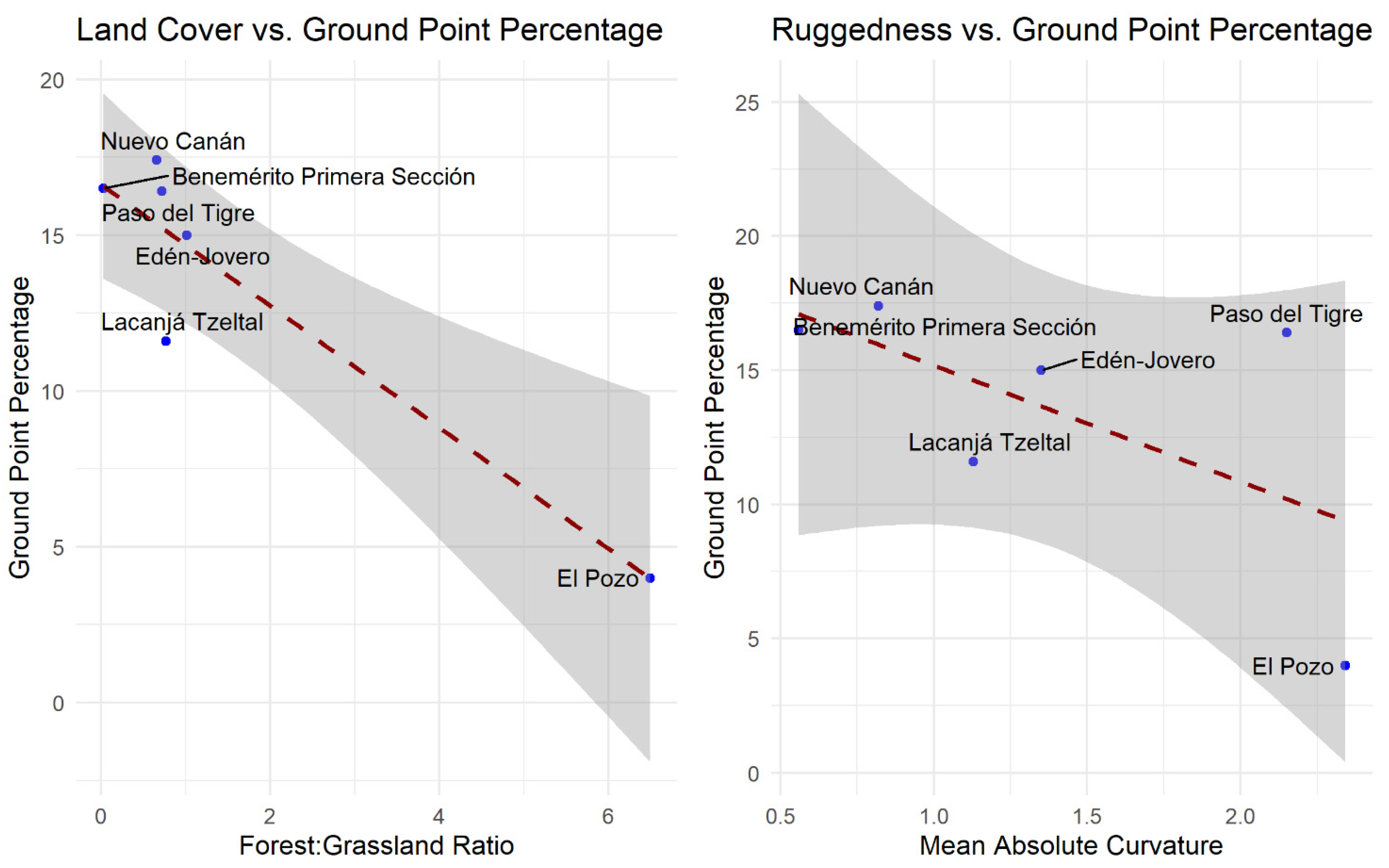
| Site | Forest: Grassland Ratio | Mean Absolute Curvature | Ground Point Percentage | Feature Density per km2 |
|---|---|---|---|---|
| Paso del Tigre | 0.722 | 2.15 | 16.4 | 72 |
| Benemérito Primera Sección | 0.0271 | 0.56 | 16.5 | 388 |
| Edén-Jovero | 1.01 | 1.35 | 15.0 | 84 |
| El Pozo | 6.49 | 2.34 | 4.0 | 10 |
| Lacanjá Tzeltal | 0.766 | 1.13 | 11.6 | 85 |
| Nuevo Canán | 0.660 | 0.82 | 17.4 | 16 |
Publisher’s Note: MDPI stays neutral with regard to jurisdictional claims in published maps and institutional affiliations. |
© 2021 by the authors. Licensee MDPI, Basel, Switzerland. This article is an open access article distributed under the terms and conditions of the Creative Commons Attribution (CC BY) license (https://creativecommons.org/licenses/by/4.0/).
Share and Cite
Schroder, W.; Murtha, T.; Golden, C.; Scherer, A.K.; Broadbent, E.N.; Almeyda Zambrano, A.M.; Herndon, K.; Griffin, R. UAV LiDAR Survey for Archaeological Documentation in Chiapas, Mexico. Remote Sens. 2021, 13, 4731. https://doi.org/10.3390/rs13234731
Schroder W, Murtha T, Golden C, Scherer AK, Broadbent EN, Almeyda Zambrano AM, Herndon K, Griffin R. UAV LiDAR Survey for Archaeological Documentation in Chiapas, Mexico. Remote Sensing. 2021; 13(23):4731. https://doi.org/10.3390/rs13234731
Chicago/Turabian StyleSchroder, Whittaker, Timothy Murtha, Charles Golden, Andrew K. Scherer, Eben N. Broadbent, Angélica M. Almeyda Zambrano, Kelsey Herndon, and Robert Griffin. 2021. "UAV LiDAR Survey for Archaeological Documentation in Chiapas, Mexico" Remote Sensing 13, no. 23: 4731. https://doi.org/10.3390/rs13234731
APA StyleSchroder, W., Murtha, T., Golden, C., Scherer, A. K., Broadbent, E. N., Almeyda Zambrano, A. M., Herndon, K., & Griffin, R. (2021). UAV LiDAR Survey for Archaeological Documentation in Chiapas, Mexico. Remote Sensing, 13(23), 4731. https://doi.org/10.3390/rs13234731