Urban Functional Zone Recognition Integrating Multisource Geographic Data
Abstract
:1. Introduction
2. Study Area and Datasets
2.1. Study Area
2.2. Datasets
3. Methods
3.1. Urban Functional Zone Feature Extraction
3.1.1. Extraction of Spectral Feature
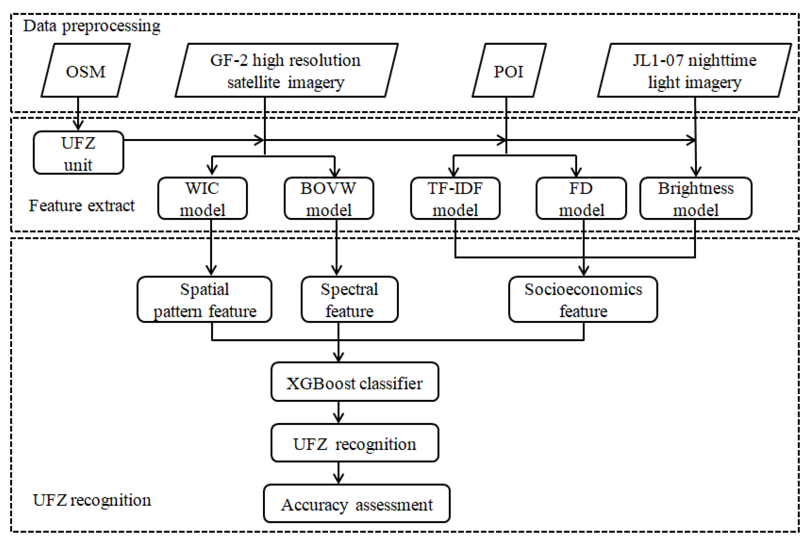
- Patch generation. To construct the BOVW model, each urban functional zone block was partitioned into a group of overlapped patches of size N*N m2. When more than 80% of the patch area belongs to a functional block, the patch belongs to this functional block, otherwise it would be excluded. In this study, N was set to 32 m and the overlap between adjacent patches was 24 m.
- Patch-level spectral feature description. The histograms of 4 multispectral were used to description the spectral feature for each patch [39]. Each image band was represented by a 32-bin histogram, leading to 128 (32*4) spectral feature histograms.
- Visual words generation. K-means unsupervised learning algorithm was used to cluster the patch-level features and generate visual words. Here, we set the k-value to 128, and acquired 128 visual words.
- Urban functional zone spectral feature construction. We assigned each image patch to its nearest visual word according to the Euclidean distance. Each functional zone block can be encoded into a frequency histogram of the 128 visual words according to the overlapped patches which belong to it.
3.1.2. Extraction of Spatial Pattern Features
- Firstly, we performed the ISODATA unsupervised spectral classification to divide the multispectral satellite image into 20 classes.
- Secondly, we calculated the nearest neighbor distance between each pixel and all the 20 spectral classes. The 20 geographical nearest neighbor distances obtained constitute the contextual feature vector of each pixel represented as . Where is the shortest distance between pixel q and a specific spectral class . is calculated as the minimum Euclidian distance between pixel q and all pixel belong to .
- Finally, urban functional zone WIC feature calculation was performed. The WIC feature of each functional zone block is the average of the context characteristics of all the pixels within it. The contextual feature vector of a pixel describes the contextual surroundings for each individual pixel. Additionally, the WIC features computed from the contextual feature vector of pixels describe the spatial pattern of objects in the urban functional zone.
3.1.3. Extraction of Socioeconomics Features from POI
3.1.4. Extraction of Socioeconomics Features from Nighttime Light Imagery
3.2. Urban Functional Zone Classification
4. Results
4.1. Experiments and Settings
4.2. Recognition Results
5. Discussion
5.1. The Block Size Parameter Setting
5.2. Comparison of Different Combination
5.2.1. Recognition Results Based on High-Resolution Remote Sensing Images and POI Data Combination
5.2.2. Recognition Results Based on Remote Sensing Image, POI Data and Nighttime Light Imagery Combination
5.3. Comparison of Different Feature
5.4. Limitations of the Proposed Method
6. Conclusions
Author Contributions
Funding
Conflicts of Interest
References
- Yao, Y.; Xia, L.; Liu, X.; Liu, P.; Ke, M. Sensing spatial distribution of urban land use by integrating points-of-interest and Google Word2Vec model. Int. J. Geogr. Inf. Sci. 2017, 31, 825–848. [Google Scholar]
- Hu, T.; Yang, J.; Li, X.; Gong, P. Mapping urban land use by using landsat images and open social data. Remote Sens. 2016, 8, 151. [Google Scholar]
- Zhou, G.; Li, C.; Li, M.; Zhang, J.; Liu, Y. Agglomeration and diffusion of urban functions: An approach based on urban land use conversion. Habitat Int. 2016, 56, 20–30. [Google Scholar]
- Sanlang, S.; Cao, S.; Du, M.; Mo, Y.; Chen, Q.; He, W. Integrating aerial lidar and very high-resolution images for urban functional zone mapping. Remote Sens. 2021, 13, 2573. [Google Scholar]
- Montanges, A.P.; Moser, G.; Taubenbock, H.; Wurm, M. Classification of urban structural types with multisource data and structured models. In 2015 Joint Urban Remote Sensing Event; IEEE: Piscataway, NJ, USA, 2015. [Google Scholar]
- Wang, Y.; Gu, Y.; Dou, M.; Qiao, M. Using spatial semantics and interactions to identify urban functional regions. ISPRS Int. J. Geo-Inf. 2018, 7, 130. [Google Scholar]
- Jiao, L.; Liu, J.; Xu, G.; Dong, T.; Gu, Y.; Zhang, B.; Liu, Y.; Liu, X. Proximity expansion index: An improved approach to characterize evolution process of urban expansion. Comput. Environ. Urban Syst. 2018, 70, 102–112. [Google Scholar]
- Huang, X.; Wang, Y. Investigating the effects of 3D urban morphology on the surface urban heat island effect in urban functional zones by using high-resolution remote sensing data: A case study of Wuhan, Central China. ISPRS J. Photogramm. Remote Sens. 2019, 152, 119–131. [Google Scholar]
- Du, S.; Du, S.; Liu, B.; Zhang, X. Mapping large-scale and fine-grained urban functional zones from VHR images using a multi-scale semantic segmentation network and object based approach. Remote Sens. Environ. 2021, 261, 112480. [Google Scholar]
- Batty, M. The size, scale, and shape of cities. Science 2008, 319, 769–771. [Google Scholar]
- Gong, J.; Liu, C.; Huang, X. Advances in urban information extraction from high-resolution remote sensing imagery. Sci. China Earth Sci. 2019, 63, 463–475. [Google Scholar]
- Zhang, X.; Du, S.; Wang, Q.; Zhou, W. Multiscale geoscene segmentation for extracting urban functional zones from VHR satellite images. Remote Sens. 2018, 10, 281. [Google Scholar]
- Zhang, X.; Du, S. A linear dirichlet mixture model for ecomposing scenes: Application to analyzing urban functional zonings. Remote Sens. Environ. 2015, 169, 37–49. [Google Scholar]
- Zhang, X.; Du, S.; Wang, Q. Hierarchical semantic cognition for urban functional zones with VHR satellite images and POI data. ISPRS J. Photogramm. Remote Sens. 2017, 132, 170–184. [Google Scholar]
- Zhang, X.; Du, S.; Wang, Q. Integrating bottom-up classification and top-down feedback for improving urban land-cover and functional-zone mapping. Remote Sens. Environ. 2018, 212, 231–248. [Google Scholar]
- Du, S.; Du, S.; Liu, B.; Zhang, X. Context-enabled extraction of large-scale urban functional zones from very-high-resolution images: A multiscale segmentation approach. Remote Sens. 2019, 11, 1902. [Google Scholar]
- Zhao, W.; Bo, Y.; Chen, J.; Tiede, D.; Blaschke, T.; Emery, W.J. Exploring semantic elements for urban scene recognition: Deep integration of high-resolution imagery and OpenStreetMap (OSM). ISPRS J. Photogramm. Remote Sens. 2019, 151, 237–250. [Google Scholar]
- Zhang, Z.; Wang, Y.; Liu, Q.; Li, L.; Wang, P. A CNN based functional zone classification method for aerial images. IEEE Int. Geosci. Remote Sens. Symp. (IGARSS) 2016, 7730419, 5449–5452. [Google Scholar]
- Zhou, W.; Ming, D.; Lv, X.; Zhou, K.; Bao, H.; Hong, Z. SO-CNN based urban functional zone fine division with VHR remote sensing. Remote Sens. Environ. 2020, 236, 111458. [Google Scholar]
- Gao, S.; Janowicz, K.; Couclelis, H. Extracting urban functional regions from points of interest and human activities on location-based social networks. Trans. GIS 2017, 21, 446–467. [Google Scholar]
- Jia, Y.; Ge, Y.; Ling, F.; Guo, X.; Wang, J.; Wang, L.; Chen, Y.; Li, X. Urban land use mapping by combining remote sensing imagery and mobile phone positioning data. Remote Sens. 2018, 10, 446. [Google Scholar]
- Zhai, W.; Bai, X.; Shi, Y.; Han, Y.; Peng, Z.R.; Gu, C. Beyond Word2vec: An approach for urban functional region extraction and identification by combining Place2vec and POIs. Comput. Environ. Urban Syst. 2019, 74, 1–12. [Google Scholar]
- Du, Z.; Zhang, X.; Li, W.; Zhang, F.; Liu, R. A multi-modal transportation data-driven approach to identify urban functional zones: An exploration based on Hangzhou City, China. Trans. GIS 2020, 24, 123–141. [Google Scholar]
- Yuan, N.J.; Zheng, Y.; Xie, X.; Wang, Y.; Zheng, K.; Xiong, H. Discovering urban functional zones using latent activity trajectories. IEEE Trans. Knowl. Data Eng. 2015, 27, 712–725. [Google Scholar]
- Hu, S.; He, Z.; Wu, L.; Yin, L.; Xu, Y.; Cui, H. A framework for extracting urban functional regions based on multiprototype word embeddings using points-of-interest data. Comput. Environ. Urban Syst. 2020, 80, 101442. [Google Scholar]
- Chen, Y.; Liu, X.; Li, X.; Liu, X.; Yao, Y.; Hu, G.; Xu, X.; Pei, F. Delineating urban functional areas with building-level social media data: A dynamic time warping (DTW) distance based k-medoids method. Landsc. Urban Plan. 2017, 160, 48–60. [Google Scholar]
- Vanderhaegen, S.; Canters, F. Mapping urban form and function at city block level using spatial metrics. Landsc. Urban Plan. 2017, 167, 399–409. [Google Scholar]
- Xing, H.; Meng, Y. Integrating landscape metrics and socioeconomic features for urban functional region classification. Comput. Environ. Urban Syst. 2018, 72, 134–145. [Google Scholar]
- Xing, H.; Meng, Y. Measuring urban landscapes for urban function classification using spatial metrics. Ecol. Indic. 2020, 108, 105722. [Google Scholar]
- Zhang, X.; Du, S.; Zheng, Z. Heuristic sample learning for complex urban scenes: Application to urban functional-zone mapping with VHR images and POI data. ISPRS J. Photogramm. Remote Sens. 2020, 161, 1–12. [Google Scholar]
- Tu, W.; Hu, Z.; Li, L.; Cao, J.; Jiang, J.; Li, Q.; Li, Q. Portraying urban functional zones by coupling remote sensing imagery and human sensing data. Remote Sens. 2018, 10, 141. [Google Scholar]
- Qian, Z.; Liu, X.; Tao, F.; Zhou, T. Identification of urban functional areas by coupling satellite images and taxi GPS trajectories. Remote Sens. 2020, 12, 2449. [Google Scholar]
- Xu, S.; Qing, L.; Han, L.; Liu, M.; Peng, Y.; Shen, L. A new remote sensing images and point-of-interest fused (RPF) model for sensing urban functional regions. Remote Sens. 2020, 12, 1032. [Google Scholar]
- Cao, R.; Tu, W.; Yang, C.; Li, Q.; Liu, J.; Zhu, J.; Zhang, Q.; Li, Q.; Qiu, G. Deep learning-based remote and social sensing data fusion for urban region function recognition. ISPRS J. Photogramm. Remote Sens. 2020, 163, 82–97. [Google Scholar]
- Bao, H.; Ming, D.; Guo, Y.; Zhang, K.; Zhou, K.; Du, S. DFCNN-based semantic recognition of urban functional zones by integrating remote sensing data and POI data. Remote Sens. 2020, 12, 1088. [Google Scholar]
- Song, J.; Lin, T.; Li, X.; Prishchepov, A.V. Mapping urban functional zones by integrating very high spatial resolution remote sensing imagery and points of interest: A case study of Xiamen, China. Remote Sens. 2018, 10, 1737. [Google Scholar]
- Levin, N.; Kyba, C.C.M.; Zhang, Q.; de Miguel, A.S.; Román, M.O.; Li, X.; Portnov, B.A.; Molthan, A.L.; Jechow, A.; Miller, S.D.; et al. Remote sensing of night lights: A review and an outlook for the future. Remote Sens. Environ. 2020, 237, 111443. [Google Scholar]
- Zhao, M.; Zhou, Y.; Li, X.; Cao, W.; He, C.; Yu, B.; Li, X.; Elvidge, C.D.; Cheng, W.; Zhou, C. Applications of satellite remote sensing of nighttime light observations: Advances, challenges, and perspectives. Remote Sens. 2019, 11, 1971. [Google Scholar]
- Huang, X.; Yang, J.; Li, J.; Wen, D. Urban functional zone mapping by integrating high spatial resolution nighttime light and daytime multi-view imagery. ISPRS J. Photogramm. Remote Sens. 2021, 175, 403–415. [Google Scholar]
- Liu, B.; Deng, Y.; Li, M.; Yang, J.; Liu, T. Classification schemes and identification methods for urban functional zone: A Review of Recent Papers. Appl. Sci. 2021, 11, 9968. [Google Scholar]
- Yuan, J.; Zheng, Y.; Xie, X. Discovering regions of different functions in a city using human mobility and POIs. In Proceedings of the ACM SIGKDD International Conference on Knowledge Discovery and Data Mining, Beijing, China, 12–16 August 2012; pp. 186–194. [Google Scholar]
- Xu, N.; Luo, J.; Wu, T.; Dong, W.; Liu, W.; Zhou, N. Identification and portrait of urban functional zones based on multisource heterogeneous data and ensemble learning. Remote Sens. 2021, 13, 373. [Google Scholar]
- Quelhas, P.; Monay, F.; Odobez, J.; Gatica-Perez, D.; Tuytelaars, T. A thousand words in a scene. IEEE Trans. Pattern Anal. Mach. Intell. 2007, 29, 1575–1589. [Google Scholar]
- Van Gemert, J.C.; Veenman, C.J.; Smeulders, A.W.M.; Geusebroek, J.M. Visual word ambiguity. IEEE Trans. Pattern Anal. Mach. Intell. 2010, 32, 1271–1283. [Google Scholar]
- Nielsen, M.M. Remote sensing for urban planning and management: The use of window-independent context segmentation to extract urban features in Stockholm. Comput. Environ. Urban Syst. 2015, 52, 1–9. [Google Scholar]
- Zheng, Q.; Weng, Q.; Huang, L.; Wang, K.; Deng, J.; Jiang, R.; Ye, Z.; Gan, M. A new source of multi-spectral high spatial resolution night-time light imagery—JL1-3B. Remote Sens. Environ. 2018, 215, 300–312. [Google Scholar]
- Huang, Z.; Qi, H.; Kang, C.; Su, Y.; Liu, Y. An ensemble learning approach for urban land use mapping based on remote sensing imagery and social sensing data. Remote Sens. 2020, 12, 3254. [Google Scholar]
- Papa, J.P.; Falcao, A.X.; Suzuki, C.T.N. Supervised pattern classification based on optimum-path forest. Int. J. Imaging Syst. Technol. 2009, 19, 120–131. [Google Scholar]


| Characteristics | High-Resolution Remote Sensing Imagery | High-Resolution Nighttime Light Imagery |
|---|---|---|
| Sensor | Gaofen-2 | Jilin1-07 |
| Spatial resolution (m) | Panchromatic:1 (subastral point 0.81) Multispectral:4 (subastral point 3.24) | 0.92 |
| Data acquired | 16 June 2019 | 25 April 2018 |
| Bands (nm) | Panchromatic: 450–900 Blue: 450–520 Green: 520–590 Red: 630–690 Infrared: 770–890 | Camera1-Blue: 426–546 Camera1-Green: 494–598 Camera1-Red: 584–738 Camera2-Blue: 424–512 Camera2-Green: 490–588 Camera2-Red: 582–730 |
| Data source link | http://www.cresda.com/CN/sjfw/zxsj/index.shtml/, accessed on 17 November 2021 | https://mall.charmingglobe.com/Sampledata/, accessed on 17 November 2021 |
| Categories | Training | Test |
|---|---|---|
| Residential zones | 105 | 423 |
| Industrial zones | 3 | 4 |
| Commercial zones | 46 | 69 |
| Parks and green spaces | 19 | 30 |
| Public service | 45 | 69 |
| Others | 3 | 4 |
| Total | 221 | 599 |
| WIC | BOVW | FD | TF-IDF | BR | OA | AccP |
|---|---|---|---|---|---|---|
| √ | 0.7245 | 0.6587 | ||||
| √ | 0.7179 | 0.6064 | ||||
| √ | 0.7179 | 0.6404 | ||||
| √ | 0.6895 | 0.6220 | ||||
| √ | 0.6928 | 0.5350 | ||||
| √ | √ | 0.7613 | 0.6661 | |||
| √ | √ | √ | √ | 0.7947 | 0.6796 | |
| √ | √ | √ | √ | √ | 0.8030 | 0.6826 |
| Patch Size (m2) | 16*16 | 32*32 | 48*48 | 64*64 |
|---|---|---|---|---|
| OA | 0.7997 | 0.8030 | 0.8013 | 0.8013 |
| AccP | 0.6891 | 0.6826 | 0.6865 | 0.6842 |
| Target | R | I | C | P1 | P2 | O | |
|---|---|---|---|---|---|---|---|
| Test | |||||||
| R | 0.874 | 0.0 | 0.043 | 0.007 | 0.076 | 0.0 | |
| I | 0.5 | 0.0 | 0.0 | 0.0 | 0.5 | 0.0 | |
| C | 0.45 | 0.0 | 0.463 | 0.0 | 0.087 | 0.0 | |
| P1 | 0.1 | 0.0 | 0.1 | 0.7 | 0.067 | 0.033 | |
| P2 | 0.435 | 0.0 | 0.087 | 0.0 | 0.478 | 0.0 | |
| O | 0.25 | 0.0 | 0.0 | 0.25 | 0.5 | 0.0 | |
| Target | R | I | C | P1 | P2 | O | |
|---|---|---|---|---|---|---|---|
| Test | |||||||
| R | 0.91 | 0.0 | 0.033 | 0.005 | 0.05 | 0.002 | |
| I | 0.0 | 0.0 | 0.0 | 0.0 | 1.0 | 0.0 | |
| C | 0.38 | 0.0 | 0.49 | 0.01 | 0.12 | 0.0 | |
| P1 | 0.067 | 0.0 | 0.1 | 0.633 | 0.167 | 0.033 | |
| P2 | 0.333 | 0.0 | 0.116 | 0.0 | 0.551 | 0.0 | |
| O | 0.5 | 0.0 | 0.0 | 0.25 | 0.25 | 0 | |
| Target | R | I | C | P1 | P2 | O | |
|---|---|---|---|---|---|---|---|
| Test | |||||||
| R | 0.92 | 0.0 | 0.028 | 0.002 | 0.047 | 0.002 | |
| I | 0.0 | 0.0 | 0.0 | 0.0 | 1.0 | 0.0 | |
| C | 0.362 | 0.0 | 0.522 | 0.014 | 0.101 | 0.0 | |
| P1 | 0.067 | 0.0 | 0.1 | 0.633 | 0.167 | 0.033 | |
| P2 | 0.33 | 0.0 | 0.13 | 0.0 | 0.54 | 0.0 | |
| O | 0.5 | 0.0 | 0.0 | 0.25 | 0.25 | 0.0 | |
Publisher’s Note: MDPI stays neutral with regard to jurisdictional claims in published maps and institutional affiliations. |
© 2021 by the authors. Licensee MDPI, Basel, Switzerland. This article is an open access article distributed under the terms and conditions of the Creative Commons Attribution (CC BY) license (https://creativecommons.org/licenses/by/4.0/).
Share and Cite
Chen, S.; Zhang, H.; Yang, H. Urban Functional Zone Recognition Integrating Multisource Geographic Data. Remote Sens. 2021, 13, 4732. https://doi.org/10.3390/rs13234732
Chen S, Zhang H, Yang H. Urban Functional Zone Recognition Integrating Multisource Geographic Data. Remote Sensing. 2021; 13(23):4732. https://doi.org/10.3390/rs13234732
Chicago/Turabian StyleChen, Siya, Hongyan Zhang, and Hangxing Yang. 2021. "Urban Functional Zone Recognition Integrating Multisource Geographic Data" Remote Sensing 13, no. 23: 4732. https://doi.org/10.3390/rs13234732
APA StyleChen, S., Zhang, H., & Yang, H. (2021). Urban Functional Zone Recognition Integrating Multisource Geographic Data. Remote Sensing, 13(23), 4732. https://doi.org/10.3390/rs13234732


