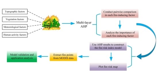
GIS-Based Forest Fire Risk Model: A Case Study in Laoshan National Forest Park, Nanjing
Abstract
:1. Introduction
- It is the first time to construct a fire risk model with actual geographic information for Nanjing Laoshan National Forest Park.
- For each influencing factor, the weights were calculated by multi-layer hierarchical analysis. The weight has passed the verification of consistency ratio, which proves the rationality of weight allocation.
- The validation result shows that the prediction accuracy of our model is close to 77%, which proves that the proposed model has good performance.
2. Study Area and Data Used
2.1. Study Area
2.2. Data Used
3. Methods
3.1. Layering and Rating of Fire Ignition Factors
3.1.1. Topographic Factors
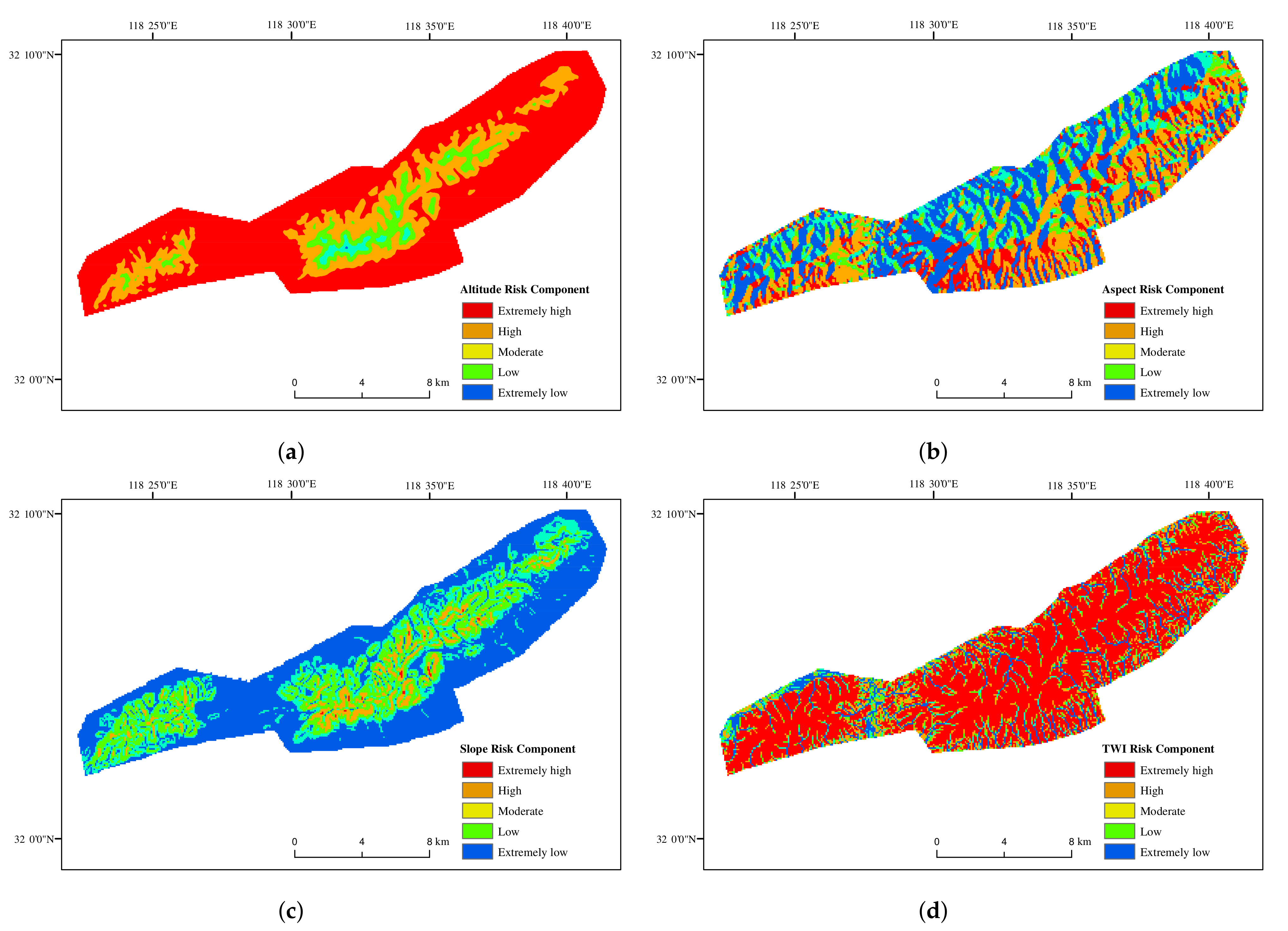
- (a) Altitude: The altitude data are reclassified to generate a new classification standard, which is divided into the following levels: extremely high, high, moderate, low, extremely low. The corresponding weight is allocated to the five classes [44]. It is shown in Table 1. The result of altitude is obtained through the elevation extraction of DEM data by ArcGIS10.5, and Figure 3 shows the based map of altitude.
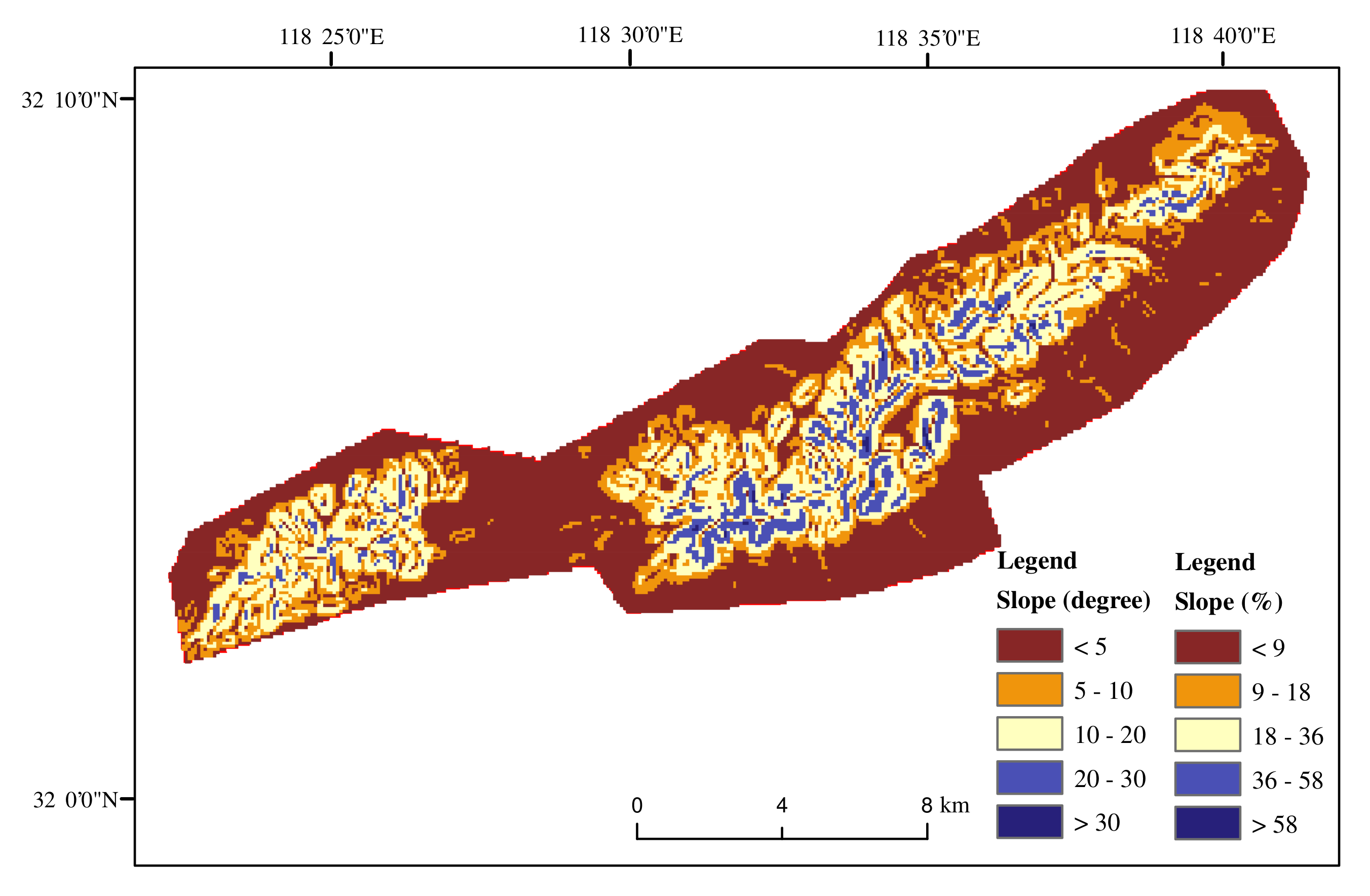
- (b) Slope: The slope of the study area is calculated by the slope function that comes with ArcGIS. Meanwhile, we also calculate the slope as a percentage. Figure 4 is the base map of the slope. The slope data is reclassified to generate a new standard, the classification standard is the same as that of altitude. The weight is allocated to the five classes in Table 2.
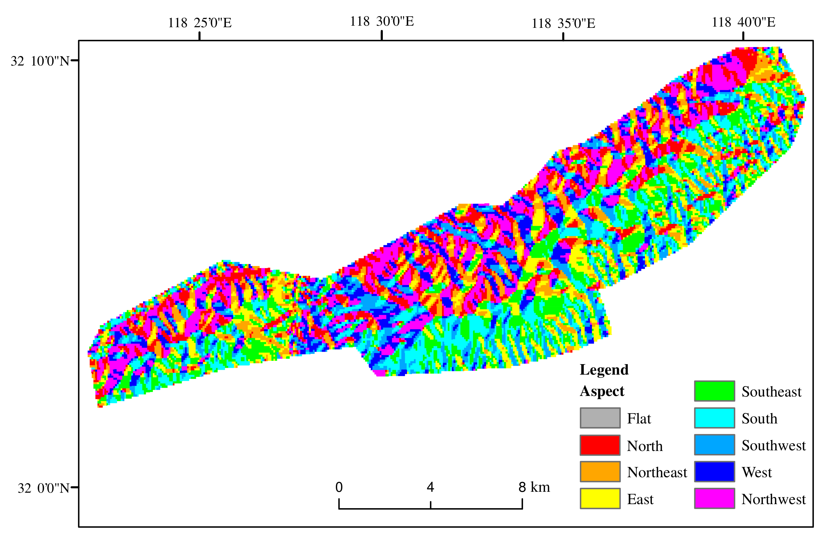
- (c) Aspect: The aspect matrix was calculated using the DEM. The aspect was classified into eight classes [19,45], which is shown in Table 3. In the northern hemisphere, the sunny slope has higher temperature and is prone to fire. Except for the tropic of cancer, the sun in other latitudes is in the south. Therefore, based on this characteristic, the slopes are divided into five grades. Figure 5 shows the base map of aspect and the weight of aspect has been listed in Table 4.
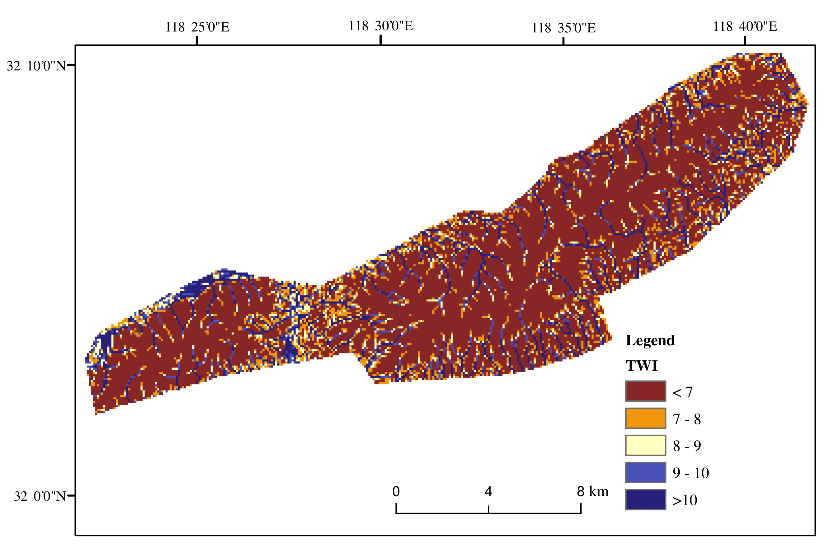
- (d) TWI: TWI is a hydrological analysis of DEM data. It considers the effects of topography and soil characteristics on soil moisture distribution [15]. Firstly, according to the actual topographic needs, the topography of the study area is filled with depressions. After filling depressions, the direction of water flow and the total amount of water flow needs to be calculated. Finally, the topographic humidity index is calculated based on the above-mentioned data. These calculations are completed in ArcGIS 10.5. The topographic wetness index has an important influence on fire occurrence and spread. Dry areas are prone to fire and spread rapidly, while wet areas are hard to cause fires [16,20]. Figure 6 shows the base map of TWI and the weight of factors is listed in Table 5.
3.1.2. Meteorological Factor
3.1.3. Vegetation Factor
3.1.4. Human Activity Factors
3.2. Generation of Weights for the Fire Risk Model
4. Result
4.1. Base Layer Classification
4.2. Forest Fire Risk Model of Laoshan
4.3. Generation of Forest Fire Risk Map
4.4. Validation of Forest Fire Risk Map
5. Discussion
5.1. Fire-Inducing Factors and Fire Risk Map
5.2. The Influence of Factors on Fire Risk Model
5.3. Accuracy and Application Analysis
6. Conclusions
Author Contributions
Funding
Institutional Review Board Statement
Informed Consent Statement
Data Availability Statement
Acknowledgments
Conflicts of Interest
References
- Martin, D.A. At the nexus of fire, water and society. Philos. Trans. R. Soc. Lond. 2016, 371, 20150172. [Google Scholar] [CrossRef] [Green Version]
- Flannigan, M.D.; Stocks, B.J.; Wotton, B.M. Climate change and forest fires. Sci. Total Environ. 2000, 262, 221–229. [Google Scholar] [CrossRef]
- Woolford, D.G.; Martell, D.L.; McFayden, C.B.; Evens, J.; Stacey, A.; Wotton, B.M.; Boychuk, D. The development and implementation of a human-caused wildland fire occurrence prediction system for the province of Ontario, Canada. Can. J. For. Res. 2021, 51, 303–325. [Google Scholar] [CrossRef]
- Carvalho, F.P.; Oliveira, J.M.; Malta, M. Exposure to radionuclides in smoke from vegetation fires. Sci. Total Environ. 2014, 472, 421–424. [Google Scholar] [CrossRef] [PubMed]
- Martins, V.; Miranda, A.I.; Carvalho, A.; Schaap, M.; Borrego, C.; Sá, E. Impact of forest fires on particulate matter and ozone levels during the 2003, 2004 and 2005 fire seasons in Portugal. Sci. Total Environ. 2012, 414, 53–62. [Google Scholar] [CrossRef] [PubMed]
- Guo, F.; Su, Z.; Wang, G.; Sun, L.; Tigabu, M.; Yang, X.; Hu, H. Understanding fire drivers and relative impacts in different Chinese forest ecosystems. Sci. Total Environ. 2017, 605–606, 411–425. [Google Scholar] [CrossRef] [PubMed]
- Pham, B.T.; Jaafari, A.; Avand, M.; Al-Ansari, N.; Dinh Du, T.; Yen, H.P.H.; Phong, T.V.; Nguyen, D.H.; Le, H.V.; Mafi-Gholami, D.; et al. Performance evaluation of machine learning methods for forest fire modeling and prediction. Symmetry 2020, 12, 1022. [Google Scholar] [CrossRef]
- Nuthammachot, N.; Stratoulias, D. Multi-criteria decision analysis for forest fire risk assessment by coupling AHP and GIS: Method and case study. Environ. Dev. Sustain. 2021, 1–16. [Google Scholar] [CrossRef]
- ChinaForestryDatabase. 2018. Available online: http://cfdb.forestry.gov.cn/lysjk/indexJump.do?url=view/moudle/index (accessed on 12 October 2020).
- Said, S.N.B.M.; Zahran, E.S.M.M.; Shams, S. Forest fire risk assessment using hotspot analysis in GIS. Open Civ. Eng. J. 2017, 11, 786–801. [Google Scholar] [CrossRef]
- Surya, L. Risk Analysis Model That Uses Machine Learning to Predict the Likelihood of a Fire Occurring at A Given Property. Int. J. Creat. Res. Thoughts IJCRT 2017, 5, 2320–2882. [Google Scholar]
- Erten, E.; Kurgun, V.; Musaolu, N. Forest Fire Risk Zone Mapping From Satellite Imagery and GIS: A Case Study. In Proceedings of the XXth Congress of the International Society for Photogrammetry and Remote Sensing, Istanbul, Turkey, 12–23 July 2004; pp. 222–230. [Google Scholar]
- Vasilakos, C.; Kalabokidis, K.; Hatzopoulos, J.; Matsinos, I. Identifying wildland fire ignition factors through sensitivity analysis of a neural network. Nat. Hazards 2009, 50, 125–143. [Google Scholar] [CrossRef]
- Oliveira, S.; Oehler, F.; San-Miguel-Ayanz, J.; Camia, A.; Pereira, J.M. Modeling spatial patterns of fire occurrence in Mediterranean Europe using Multiple Regression and Random Forest. For. Ecol. Manag. 2012, 275, 117–129. [Google Scholar] [CrossRef]
- Pourtaghi, Z.S.; Pourghasemi, H.R.; Aretano, R.; Semeraro, T. Investigation of general indicators influencing on forest fire and its susceptibility modeling using different data mining techniques. Ecol. Indic. 2016, 64, 72–84. [Google Scholar] [CrossRef]
- Çolak, E.; Sunar, F. Evaluation of forest fire risk in the Mediterranean Turkish forests: A case study of Menderes region, Izmir. Int. J. Disaster Risk Reduct. 2020, 45, 101479. [Google Scholar] [CrossRef]
- Tian, X.; Zhao, F.; Shu, L.; Wang, M. Distribution characteristics and the influence factors of forest fires in China. For. Ecol. Manag. 2013, 310, 460–467. [Google Scholar] [CrossRef]
- Sánchez, J.M.; Bisquert, M.; Rubio, E.; Caselles, V. Impact of Land Cover Change Induced by a Fire Event on the Surface Energy Fluxes Derived from Remote Sensing. Remote Sens. 2015, 7, 14899–14915. [Google Scholar] [CrossRef] [Green Version]
- Lloyd, H.G. Influence of altitude and aspect on daily variations in factors of forest-fire danger. Remote Sens. Environ. 2006, 105, 142–154. [Google Scholar]
- Dieu, T.B.; Le, K.T.; Van, N.; Le, H.; Inge, R. Tropical Forest Fire Susceptibility Mapping at the Cat Ba National Park Area, Hai Phong City, Vietnam, Using GIS-Based Kernel Logistic Regression. Remote Sens. 2016, 8, 347. [Google Scholar]
- Balch, J.K.; Bradley, B.A.; Abatzoglou, J.T.; Nagy, R.C.; Fusco, E.J.; Mahood, A.L. Human-started wildfires expand the fire niche across the United States. Proc. Natl. Acad. Sci. USA 2017, 114, 2946–2951. [Google Scholar] [CrossRef] [PubMed] [Green Version]
- Parisien, M.A.; Miller, C.; Parks, S.A.; Delancey, E.R.; Robinne, F.N.; Flannigan, M. The spatially varying influence of humans on fire probability in North America. Environ. Res. Lett. 2016, 11, 075005. [Google Scholar] [CrossRef] [Green Version]
- Eugenio, F.C.; dos Santos, A.R.; Fiedler, N.C.; Ribeiro, G.A.; da Silva, A.G.; dos Santos, Á.B.; Paneto, G.G.; Schettino, V.R. Applying GIS to develop a model for forest fire risk: A case study in Espírito Santo, Brazil. J. Environ. Manag. 2016, 173, 65–71. [Google Scholar] [CrossRef]
- Abedi Gheshlaghi, H.; Feizizadeh, B.; Blaschke, T. GIS-based forest fire risk mapping using the analytical network process and fuzzy logic. J. Environ. Plan. Manag. 2020, 63, 481–499. [Google Scholar] [CrossRef]
- Li, S.Y.; Tao, G.; Zhang, L.J. Fire Risk Assessment of High-rise Buildings Based on Gray-FAHP Mathematical Model. Procedia Eng. 2018, 211, 395–402. [Google Scholar] [CrossRef]
- Eskandari, S. A new approach for forest fire risk modeling using fuzzy AHP and GIS in Hyrcanian forests of Iran. Arab. J. Geosci. 2017, 10, 190. [Google Scholar] [CrossRef]
- Pourghasemi, H.R.; Beheshtirad, M.; Pradhan, B. A comparative assessment of prediction capabilities of modified analytical hierarchy process (M-AHP) and Mamdani fuzzy logic models using Netcad-GIS for forest fire susceptibility mapping. Geomat. Nat. Hazards Risk 2016, 7, 861–885. [Google Scholar] [CrossRef] [Green Version]
- Dimuccio, L.A.; Figueiredo, R.F.; Cunha, L.; Almeida, A.C.D. Regional forest-fire susceptibility analysis in central Portugal using a probabilistic ratings procedure and artificial neural network weights assignment. Int. J. Wildland Fire 2011, 20, 776–791. [Google Scholar] [CrossRef]
- Finney, M.A. The challenge of quantitative risk analysis for wildland fire. For. Ecol. Manag. 2005, 211, 97–108. [Google Scholar] [CrossRef]
- Matin, M.A.; Chitale, V.S.; Murthy, M.S.R.; Uddin, K.; Bajracharya, B.; Pradhan, S. Understanding forest fire patterns and risk in Nepal using remote sensing, geographic information system and historical fire data. Int. J. Wildland Fire 2017, 26, 276. [Google Scholar] [CrossRef] [Green Version]
- Zhao, W.H.; Shan, H.B.; Zhong, R.X. A new model for the MODIS fire monitoring:normalized difference thermal index. J. Nat. Disasters 2008, 17, 152–157. [Google Scholar]
- Zhang, F.; Zhao, P.; Thiyagalingam, J.; Kirubarajan, T. Terrain-Influenced Incremental Watchtower Expansion for Wildfire Detection. Sci. Total Environ. 2019, 654, 164–176. [Google Scholar] [CrossRef] [PubMed]
- Lee, C.; Kim, K.; Lee, H. GIS based optimal impervious surface map generation using various spatial data for urban nonpoint source management. J. Environ. Manag. 2018, 206, 587–601. [Google Scholar] [CrossRef]
- Semeraro, T.; Mastroleo, G.; Aretano, R.; Facchinetti, G.; Zurlini, G.; Petrosillo, I. GIS Fuzzy Expert System for the assessment of ecosystems vulnerability to fire in managing Mediterranean natural protected areas. J. Environ. Manag. 2016, 168, 94–103. [Google Scholar] [CrossRef]
- Jakovljević, G.; Gigović, L.; Sekulovic, D.; Regodić, M. GIS Multi-Criteria Analysis for Identifying and Mapping Forest Fire Hazard: Nevesinje, Bosnia and Herzegovina. Teh. Vjesn. 2018, 25, 891–897. [Google Scholar]
- Kavlak, M.O.; Cabuk, S.N.; Cetin, M. Development of forest fire risk map using geographical information systems and remote sensing capabilities: Ören case. Environ. Sci. Pollut. Res. 2021, 28, 33265–33291. [Google Scholar] [CrossRef] [PubMed]
- Alcasena, F.J.; Salis, M.; Ager, A.A.; Castell, R.; Vega-García, C. Assessing wildland fire risk transmission to communities in northern Spain. Forests 2017, 8, 30. [Google Scholar] [CrossRef] [Green Version]
- Konkathi, P.; Shetty, A.; Kolluru, V.; Yathish, P.; Pruthviraj, U. Static Fire Risk Index for the Forest Resources of Karnataka. In Proceedings of the IGARSS 2019—2019 IEEE International Geoscience and Remote Sensing Symposium, Yokohama, Japan, 28 July–2 August 2019; pp. 6716–6719. [Google Scholar]
- You, W.; Li, L.; Wu, L.; Ji, Z.; Yu, J.; Zhu, J.; Fan, Y.; He, D. Geographical information system-based forest fire risk assessment integrating national forest inventory data and analysis of its spatiotemporal variability. Ecol. Indic. 2017, 77, 176–184. [Google Scholar] [CrossRef]
- Yue, Y.; Dong, K.; Zhao, X.; Ye, X. Assessing wild fire risk in the United States using social media data. J. Risk Res. 2019, 1–15. [Google Scholar] [CrossRef]
- Akay, A.; Erdoğan, A. GIS-based multi-criteria decision analysis for forest fire risk mapping. ISPRS Ann. Photogramm. Remote Sens. Spat. Inf. Sci. 2017, 4, 25. [Google Scholar] [CrossRef] [Green Version]
- Conedera, M.; Peter, L.; Marxer, P.; Forster, F.; Rickenmann, D.; Re, L. Consequences of forest fires on the hydrogeological response of mountain catchments: A case study of the Riale Buffaga, Ticino, Switzerland. Earth Surf. Process. Landf. 2010, 28, 117–129. [Google Scholar] [CrossRef]
- Lira, P.K.; Tambosi, L.R.; Ewers, R.M.; Metzger, J.P. Land-use and land-cover change in Atlantic Forest landscapes. For. Ecol. Manag. 2012, 278, 80–89. [Google Scholar] [CrossRef]
- Ribeiro, L.; de Paulo Koproski, L.; Stolle, L.; Lingnau, C.; Soares, R.V.; Batista, A.C. Zoneamento de riscos de incêndios florestais para a Fazenda Experimental do Canguiri, Pinhais (PR) ([Fire risk map for the Canguiri Experimental Farm, Pinhais (PR)]). Floresta 2008, 28, 561–572. [Google Scholar]
- Nelson, N.A.; Pierce, J. Late-Holocene relationships among fire, climate and vegetation in a forest-sagebrush ecotone of southwestern Idaho, USA. Holocene 2010, 20, 1179–1194. [Google Scholar] [CrossRef]
- Walawender, J.P.; Szymanowski, M.; Hajto, M.J.; Bokwa, A. Land Surface Temperature Patterns in the Urban Agglomeration of Krakow (Poland) Derived from Landsat-7/ETM+ Data. Pure Appl. Geophys. 2014, 171, 913–940. [Google Scholar] [CrossRef] [Green Version]
- Brabyn, L.; Zawar-Reza, P.; Stichbury, G.; Cary, C.; Storey, B.; Laughlin, D.C.; Katurji, M. Accuracy assessment of land surface temperature retrievals from Landsat 7 ETM + in the Dry Valleys of Antarctica using iButton temperature loggers and weather station data. Environ. Monit. Assess. 2014, 186, 2619–2628. [Google Scholar] [CrossRef] [PubMed]
- Rossa, C.G. The effect of fuel moisture content on the spread rate of forest fires in the absence of wind or slope. Int. J. Wildland Fire 2017, 26, 24–31. [Google Scholar] [CrossRef]
- Bilgili, E.; Coskuner, K.A.; Usta, Y.; Goltas, M. Modeling surface fuels moisture content in Pinus brutia stands. J. For. Res. 2019, 30, 577–587. [Google Scholar] [CrossRef]
- Hong, H.; Tsangaratos, P.; Ilia, I.; Liu, J.; Zhu, A.X.; Chong, X. Applying genetic algorithms to set the optimal combination of forest fire related variables and model forest fire susceptibility based on data mining models. The case of Dayu County, China. Sci. Total Environ. 2018, 630, 1044–1056. [Google Scholar] [CrossRef]
- Ricotta, C.; Bajocco, S.; Guglietta, D.; Conedera, M. Assessing the influence of roads on fire ignition: Does land cover matter? Fire 2018, 1, 24. [Google Scholar] [CrossRef] [Green Version]
- Wu, Z.; He, H.S.; Jian, Y.; Liu, Z.; Yu, L. Relative effects of climatic and local factors on fire occurrence in boreal forest landscapes of northeastern China. Sci. Total Environ. 2014, 493, 472–480. [Google Scholar] [CrossRef]
- Saaty, T.L. A scaling method for priorities in hierarchical structures. J. Math. Psychol. 1977, 15, 234–281. [Google Scholar] [CrossRef]
- Kang, H.; Zhai, F.; Gao, W. Construction of Rural Fire Risk Assessment System Based on Analytic Hierarchy Process: A Case Study of Tuyang Village in Shenzhen. In Proceedings of the International Conference on Construction and Real Estate Management (ICCREM 2017), Guangzhou, China, 10–12 November 2017; pp. 353–359. [Google Scholar]
- Taridala, S.; Yudono, A.; Ramli, M.; Akil, A. Expert system development for urban fire hazard assessment. Study case: Kendari City, Indonesia. IOP Conf. Ser. Earth Environ. Sci. 2017, 79, 012035. [Google Scholar] [CrossRef] [Green Version]
- Chen, J.J.; Fang, Z.; Wang, J.H.; Guo, X.J. Research on building fire risk assessment based on analytic hierarchy process (AHP). In Proceedings of the International Conference on Intelligent Computation Technology &Automation, Changsha, China, 25–26 October 2014. [Google Scholar]
- Nuthammachot, N.; Stratoulias, D. A GIS- and AHP-based approach to map fire risk: A case study of Kuan Kreng peat swamp forest, Thailand. Geocarto Int. 2021, 36, 212–225. [Google Scholar] [CrossRef]
- Anees, A.; Aryal, J.; O’Reilly, M.M.; Gale, T.J. A Relative Density Ratio-Based Framework for Detection of Land Cover Changes in MODIS NDVI Time Series. IEEE J. Sel. Top. Appl. Earth Obs. Remote Sens. 2016, 9, 3359–3371. [Google Scholar] [CrossRef]
- Szpakowski, D.M.; Jennifer, J.L.R. A Review of the Applications of Remote Sensing in Fire Ecology. Remote Sens. 2019, 11, 2638. [Google Scholar] [CrossRef] [Green Version]
- Costafreda-Aumedes, S.; Comas, C.; Vega-Garcia, C. Human-caused fire occurrence modelling in perspective: A review. Int. J. Wildland Fire 2017, 26, 983–998. [Google Scholar] [CrossRef]
- Dutta, R.; Aryal, J.; Das, A.; Kirkpatrick, J.B. Deep cognitive imaging systems enable estimation of continental-scale fire incidence from climate data. Sci. Rep. 2013, 3, 3188. [Google Scholar] [CrossRef] [Green Version]
- Cheret, V.; Denux, J.P. Analysis of MODIS NDVI Time Series to Calculate Indicators of Mediterranean Forest Fire Susceptibility. GIScience Remote Sens. 2011, 48, 171–194. [Google Scholar] [CrossRef]
- Chakraborty, S.; Banerjee, A.; Gupta, S.; Papandreou-Suppappola, A.; Christensen, P. Estimation of dynamic parameters of MODIS NDVI time series nonlinear model using particle filtering. In Proceedings of the IEEE International Geoscience & Remote Sensing Symposium, Fort Worth, TX, USA, 23–28 July 2017. [Google Scholar]
- Rasooli, S.B.; Bonyad, A.E. Evaluating the efficiency of the Dong model in determining fire vulnerability in Iran’s Zagros forests. J. For. Res. 2019, 30, 1447–1458. [Google Scholar] [CrossRef]
- Giglio, L.; Van der Werf, G.; Randerson, J.; Collatz, G.; Kasibhatla, P. Global estimation of burned area using MODIS active fire observations. Atmos. Chem. Phys. 2006, 6, 957–974. [Google Scholar] [CrossRef] [Green Version]
- Suryabhagavan, K.; Alemu, M.; Balakrishnan, M. GIS-based multi-criteria decision analysis for forest fire susceptibility mapping: A case study in Harenna forest, southwestern Ethiopia. Trop. Ecol. 2016, 57, 33–43. [Google Scholar]
- Chen, X.; Jiang, K.; Zhu, Y.; Wang, X.; Yun, T. Individual Tree Crown Segmentation Directly from UAV-Borne LiDAR Data Using the PointNet of Deep Learning. Forests 2021, 12, 131. [Google Scholar] [CrossRef]
- Kayet, N.; Chakrabarty, A.; Pathak, K.; Sahoo, S.; Dutta, T.; Hatai, B.K. Comparative analysis of multi-criteria probabilistic FR and AHP models for forest fire risk (FFR) mapping in Melghat Tiger Reserve (MTR) forest. J. For. Res. 2020, 31, 565–579. [Google Scholar] [CrossRef]
- Kilic, S.; Ozkan, O. A self-adaptive UAV routing for forest fire risk mitigation: A conceptual model. In Proceedings of the 2019 Summer Simulation Conference, Berlin, Germany, 22–24 July 2019. [Google Scholar]
- Sudhakar, S.; Vijayakumar, V.; Kumar, C.S.; Priya, V.; Ravi, L.; Subramaniyaswamy, V. Unmanned Aerial Vehicle (UAV) based Forest Fire Detection and monitoring for reducing false alarms in forest-fires. Comput. Commun. 2020, 149, 1–16. [Google Scholar] [CrossRef]
- De Vivo, F.; Battipede, M.; Johnson, E. Infra-red line camera data-driven edge detector in UAV forest fire monitoring. Aerosp. Sci. Technol. 2021, 111, 106574. [Google Scholar]
- Bao, S.; Xiao, N.; Lai, Z.; Zhang, H.; Kim, C. Optimizing watchtower locations for forest fire monitoring using location models. Fire Saf. J. 2015, 71, 100–109. [Google Scholar] [CrossRef]



| Altitude (m) | Weight | Risk |
|---|---|---|
| <100 | 5 | Extremely high |
| 100–200 | 4 | High |
| 200–300 | 3 | Moderate |
| 300–400 | 2 | Low |
| >400 | 1 | Extremely low |
| Slope () | Slope (%) | Weight | Risk |
|---|---|---|---|
| >30 | >58 | 5 | Extremely high |
| 20–30 | 36–58 | 4 | High |
| 10–20 | 18–36 | 3 | Moderate |
| 5–10 | 9–18 | 2 | Low |
| <5 | <9 | 1 | Extremely low |
| Aspect | Degre |
|---|---|
| N-NE | 0– |
| NE-E | – |
| E-SE | – |
| SE-S | – |
| S-SW | 1 – |
| SW-W | – |
| W-NW | – |
| NW-N | – |
| Aspect | Weight | Risk |
|---|---|---|
| S | 5 | Extremely high |
| SE and E | 4 | High |
| NE | 3 | Moderate |
| N | 2 | Low |
| W, NW, SW and FLAT | 1 | Extremely low |
| TWI | Weight | Risk |
|---|---|---|
| <7 | 5 | Extremely high |
| 7–8 | 4 | High |
| 8–9 | 3 | Moderate |
| 9–10 | 2 | Low |
| >10 | 1 | Extremely low |
| Temperature (C) | Weight | Risk |
|---|---|---|
| >31 | 5 | Extremely high |
| 29–31 | 4 | High |
| 27–29 | 3 | Moderate |
| 25–27 | 2 | Low |
| <25 | 1 | Extremely low |
| Weight | Risk | |
|---|---|---|
| <0 | 5 | Extremely high |
| 0–0.15 | 4 | High |
| 0.15–0.3 | 3 | Moderate |
| 0.3–0.45 | 2 | Low |
| > | 1 | Extremely low |
| Distance to Roads (m) | Weight | Risk |
|---|---|---|
| <300 | 5 | Extremely high |
| 300–600 | 4 | High |
| 600–900 | 3 | Moderate |
| 900–1200 | 2 | Low |
| >1200 | 1 | Extremely low |
| Populated Areas | Weight | Risk |
|---|---|---|
| <400 | 5 | Extremely high |
| 400–800 | 4 | High |
| 800–1200 | 3 | Moderate |
| 1200–1600 | 2 | Low |
| >1600 | 1 | Extremely low |
| Factors | Factors | Weight | ||||
|---|---|---|---|---|---|---|
| Altitude | Slope | Aspect | TWI | |||
| Altitude | 1 | 2 | 3 | 1/2 | 0.2863 | |
| Topographic | Slope | 1/2 | 1 | 2 | 1/2 | 0.1820 |
| Factors | Aspect | 1/3 | 1/2 | 1 | 1/4 | 0.0969 |
| TWI | 2 | 2 | 4 | 1 | 0.4348 | |
| DTR | DTP | |||||
| Human Activity | DTR | 1 | 3 | 0.75 | ||
| Factors | DTP | 1/3 | 1 | 0.25 |
| Topographic | Temperature | Human Activity | Weight | ||
|---|---|---|---|---|---|
| Topographic | 1 | 1/2 | 1/3 | 1/3 | 0.1059 |
| Temperature | 2 | 1 | 1/3 | 1/2 | 0.1636 |
| 3 | 3 | 1 | 2 | 0.4476 | |
| Human Activity | 3 | 2 | 1/2 | 1 | 0.2829 |
| Influence Factors of Forest Fire | Risk |
|---|---|
| 0.0103 | |
| 0.0193 | |
| 0.0303 | |
| 0.0461 | |
| 0.0707 | |
| 0.1636 | |
| 0.2122 | |
| 0.4476 |
Publisher’s Note: MDPI stays neutral with regard to jurisdictional claims in published maps and institutional affiliations. |
© 2021 by the authors. Licensee MDPI, Basel, Switzerland. This article is an open access article distributed under the terms and conditions of the Creative Commons Attribution (CC BY) license (https://creativecommons.org/licenses/by/4.0/).
Share and Cite
Zhao, P.; Zhang, F.; Lin, H.; Xu, S. GIS-Based Forest Fire Risk Model: A Case Study in Laoshan National Forest Park, Nanjing. Remote Sens. 2021, 13, 3704. https://doi.org/10.3390/rs13183704
Zhao P, Zhang F, Lin H, Xu S. GIS-Based Forest Fire Risk Model: A Case Study in Laoshan National Forest Park, Nanjing. Remote Sensing. 2021; 13(18):3704. https://doi.org/10.3390/rs13183704
Chicago/Turabian StyleZhao, Pengcheng, Fuquan Zhang, Haifeng Lin, and Shuwen Xu. 2021. "GIS-Based Forest Fire Risk Model: A Case Study in Laoshan National Forest Park, Nanjing" Remote Sensing 13, no. 18: 3704. https://doi.org/10.3390/rs13183704
APA StyleZhao, P., Zhang, F., Lin, H., & Xu, S. (2021). GIS-Based Forest Fire Risk Model: A Case Study in Laoshan National Forest Park, Nanjing. Remote Sensing, 13(18), 3704. https://doi.org/10.3390/rs13183704


