
Prospecting the UNESCO World Heritage Site of Müstair (Switzerland)

 ,
,  ,
,  , , , and
Abstract
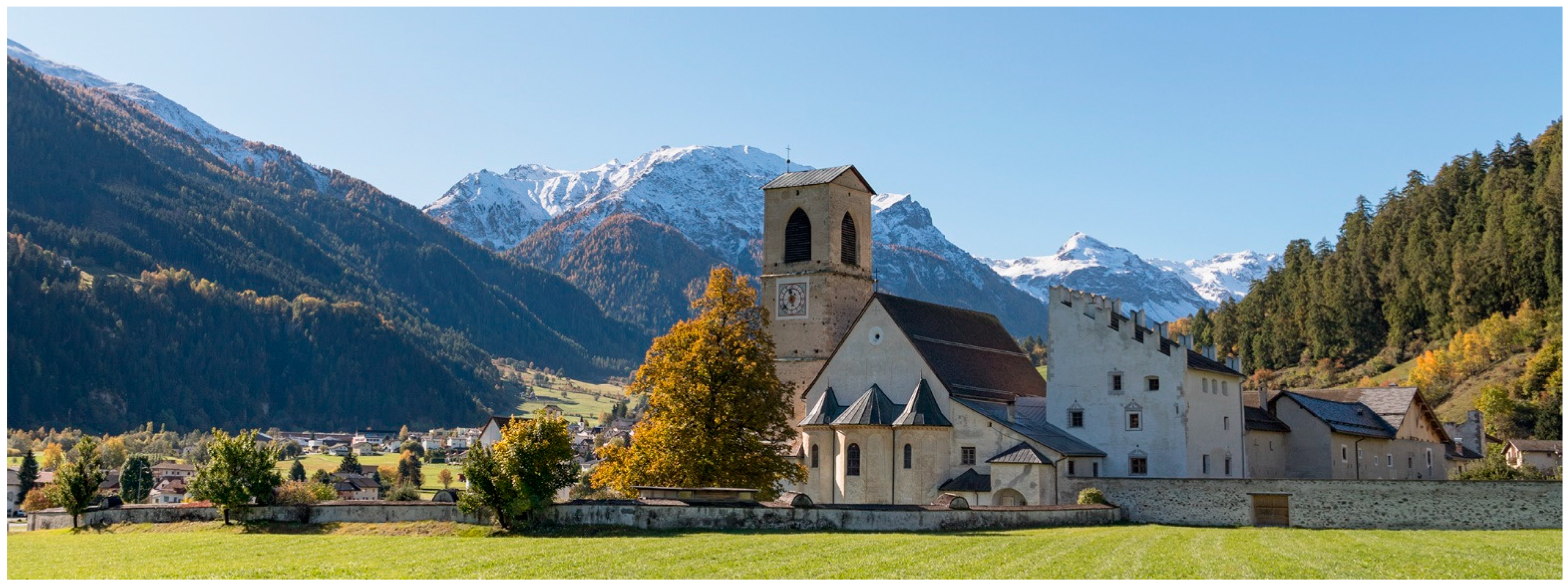
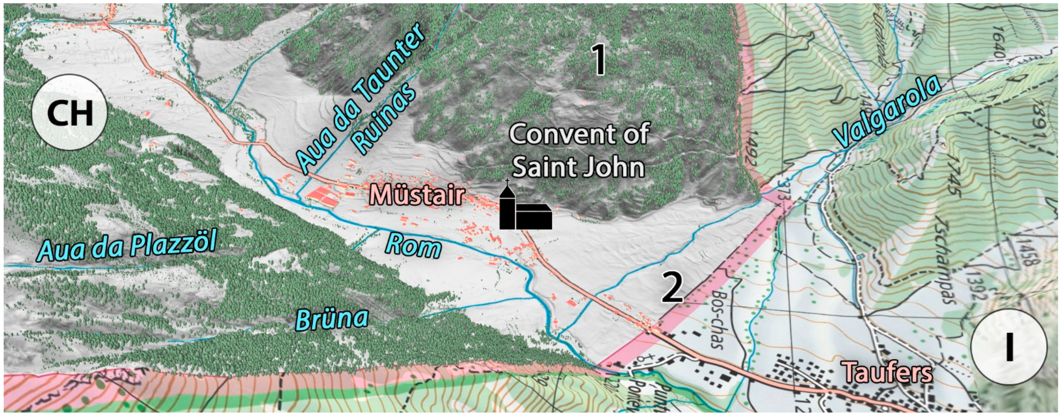
1. Introduction
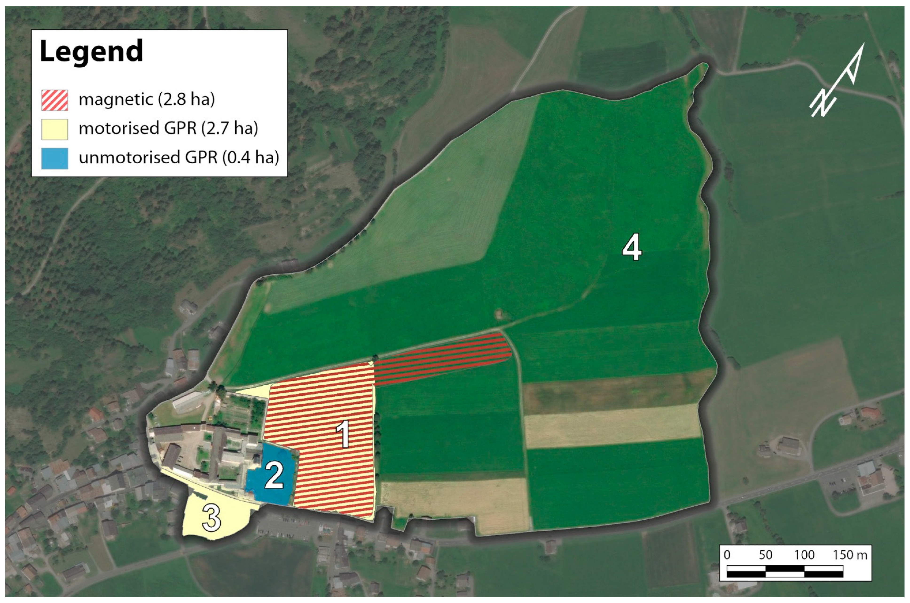
2. Geophysical Surveys
3. Data Processing
4. Results and Discussion
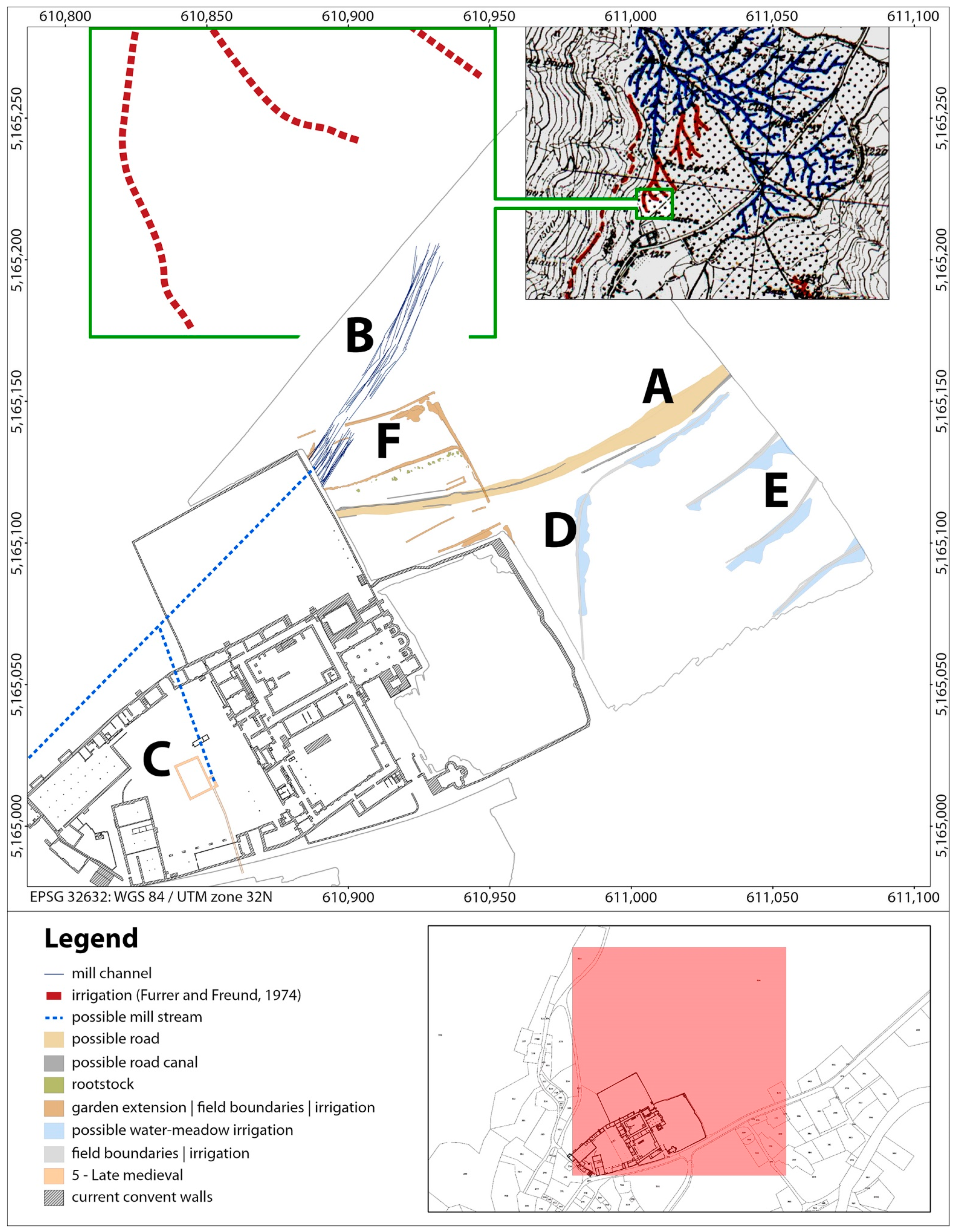
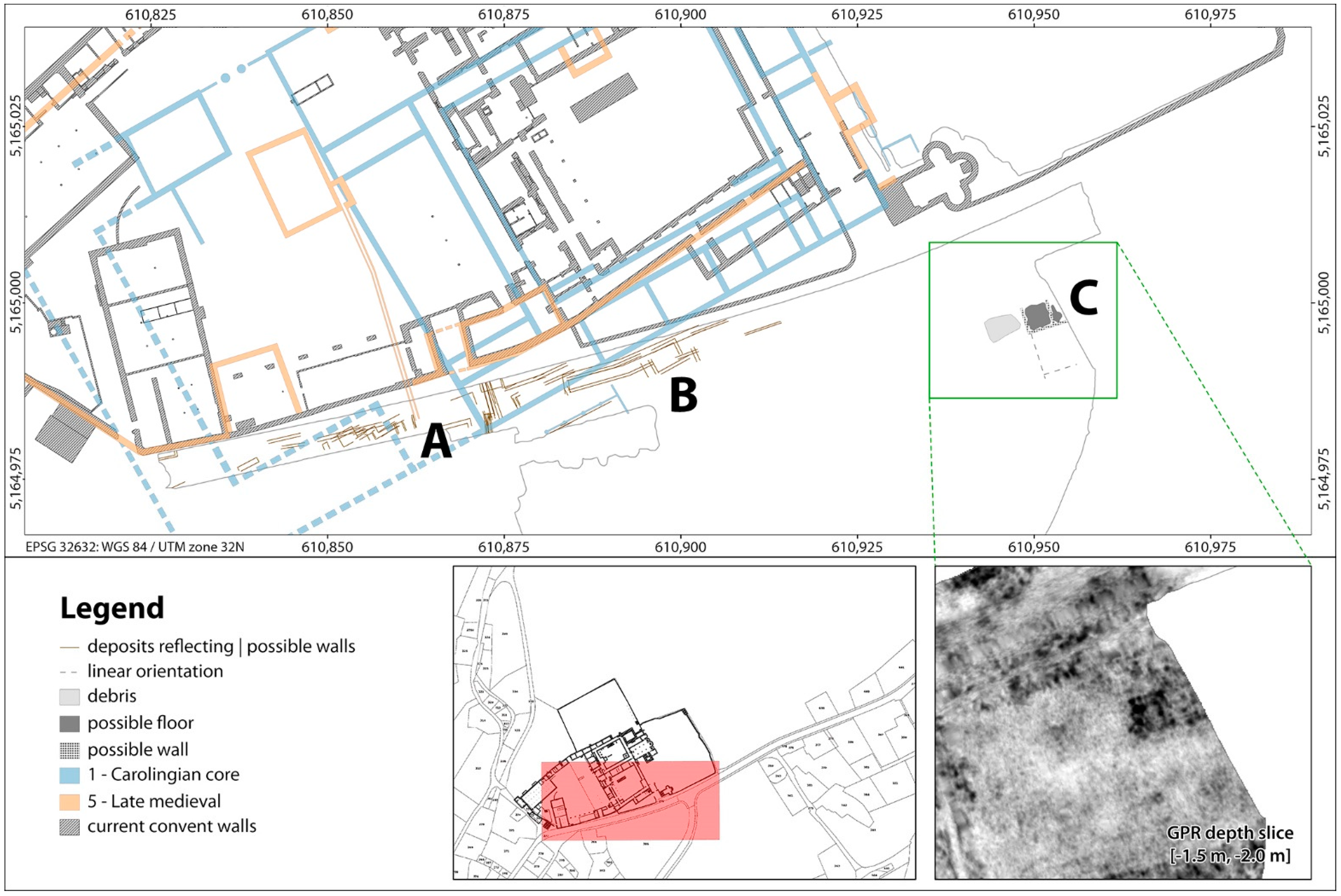
4.1. Roads
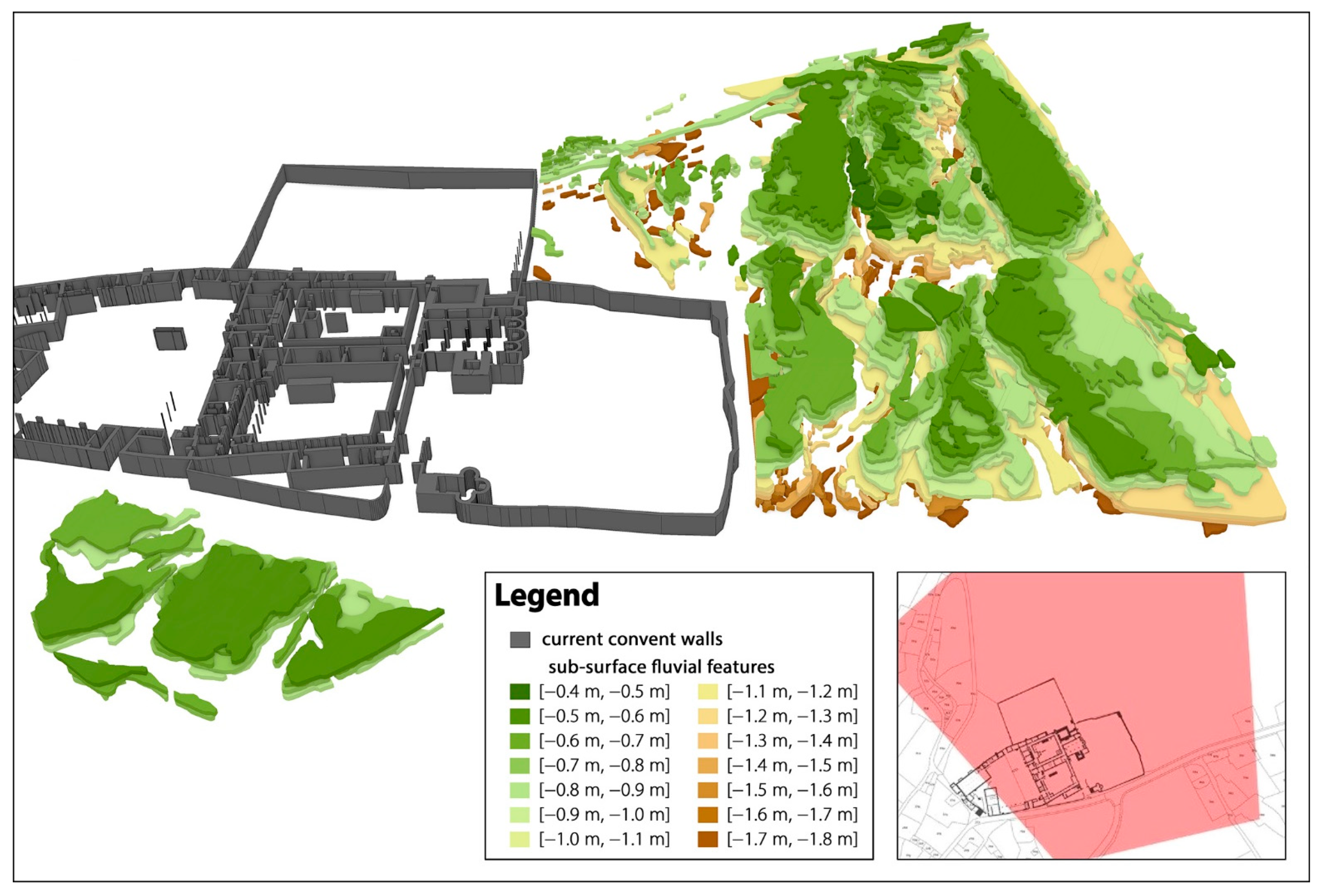
4.2. Natural Fluvial Features
4.3. Drainage, Water Supply, and Irrigation Systems
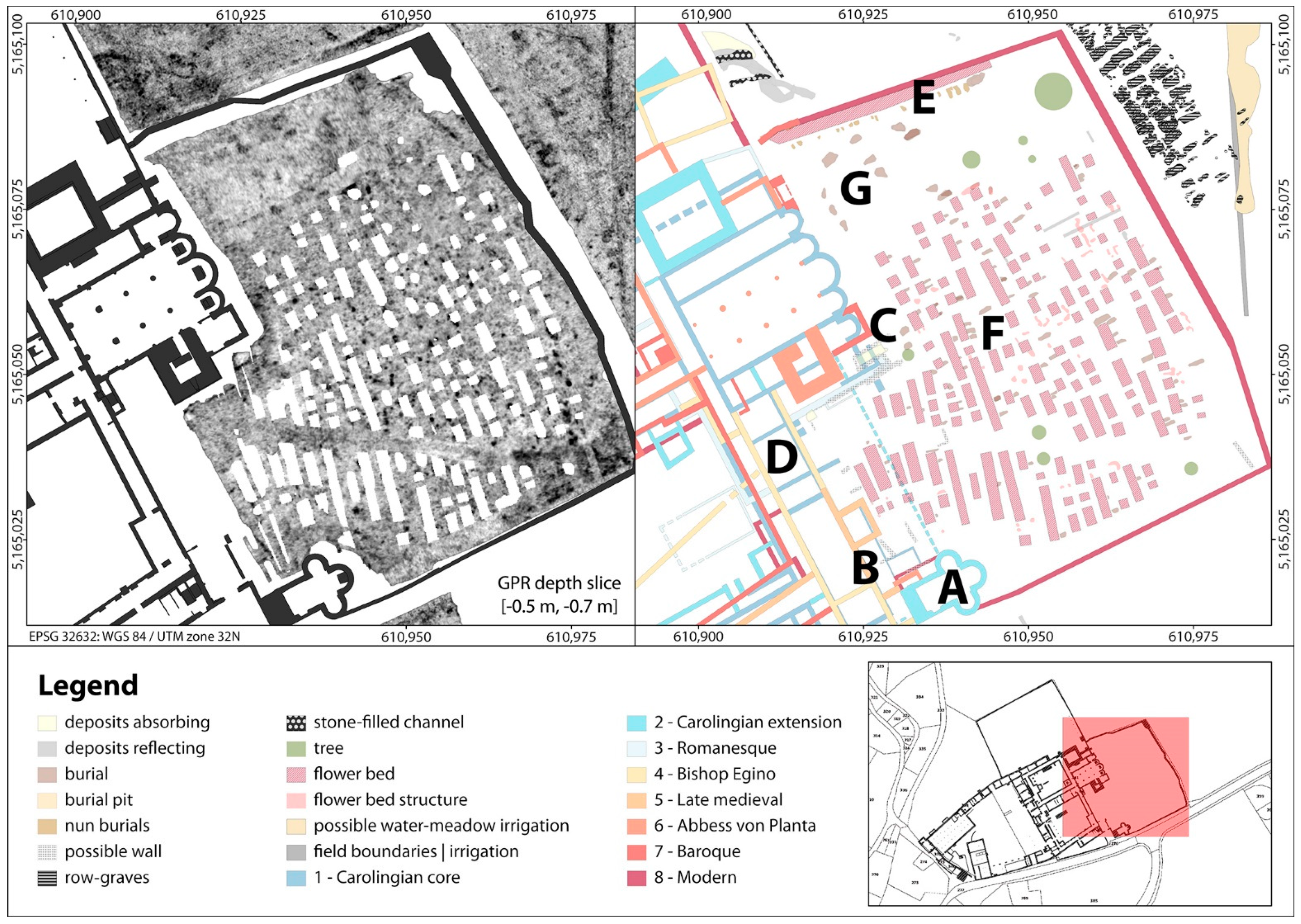
4.4. Herb Garden
4.5. Building Structures Connected to the Convent
4.5.1. Carolingian and Undated Building Southern Structures
4.5.2. Around the Plantatower
4.5.3. The Eginotower and the Surrounding Building
4.5.4. The Holy Cross Chapel and Attached Building Structures
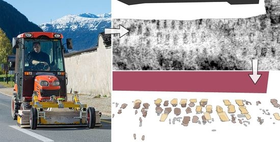
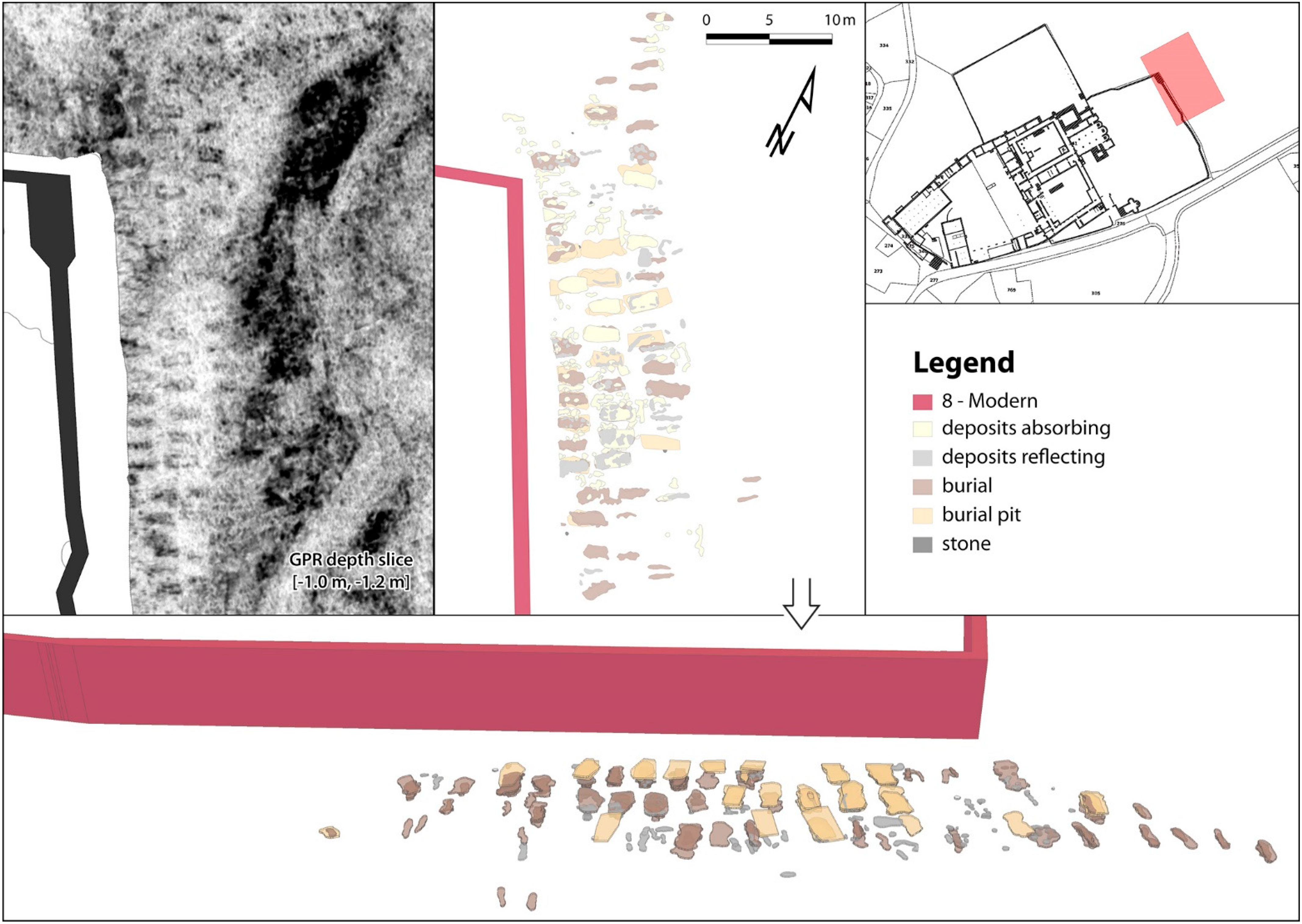
4.6. Burial Grounds
4.6.1. The Present Graveyard
4.6.2. The Nun Graves
4.6.3. Row Graves
5. Conclusions and Outlook
Author Contributions
Funding
Institutional Review Board Statement
Informed Consent Statement
Data Availability Statement
Acknowledgments
Conflicts of Interest
References
- Courvoisier, H.R.; Sennhauser, H.R. Einleitung. In Müstair, Kloster St. Johann: Volume 1. Zur Klosteranlage Vorklösterliche Befunde; Sigel, B., Ed.; VDF Hochschulverlag AG an der ETH Zürich: Zürich, Switzerland, 1996; pp. 9–12. ISBN 978-3-7281-2272-8. [Google Scholar]
- Sigel, B. (Ed.) Müstair, Kloster St. Johann: Volume 1. Zur Klosteranlage Vorklösterliche Befunde; Vdf Hochschulverlag AG an der ETH Zürich: Zürich, Switzerland, 1996; ISBN 978-3-7281-2272-8. [Google Scholar]
- Joos, M. Zur Sedimentation im Klosterareal von Müstair. In Müstair, Kloster St. Johann: Volume 1. Zur Klosteranlage Vorklösterliche Befunde; Sigel, B., Ed.; VDF Hochschulverlag AG an der ETH Zürich: Zürich, Switzerland, 1996; pp. 199–233. ISBN 978-3-7281-2272-8. [Google Scholar]
- Trümpy, R. Zur Geologie des Münstertals (Val Müstair). In Müstair, Kloster St. Johann: Volume 4. Naturwissenschaftliche und Technische Beiträge; Sennhauser, H.R., Ed.; VDF Hochschulverlag AG an der ETH Zürich: Zürich, Switzerland, 2007; pp. 11–22. ISBN 978-3-7281-3116-4. [Google Scholar]
- Leckebusch, J. Ground-penetrating radar: A modern three-dimensional prospection method. Archaeol. Prospect. 2003, 10, 213–240. [Google Scholar] [CrossRef]
- Trinks, I.; Hinterleitner, A.; Neubauer, W.; Nau, E.; Löcker, K.; Wallner, M.; Gabler, M.; Filzwieser, R.; Wilding, J.; Schiel, H.; et al. Large-area high-resolution ground-penetrating radar measurements for archaeological prospection. Archaeol. Prospect. 2018, 25, 171–195. [Google Scholar] [CrossRef]
- Dodge, M.; Kitchin, R.; Perkins, C.R. Preface: Introducing The Map Reader. In The Map Reader: Theories of Mapping Practice and Cartographic Representation; Dodge, M., Kitchin, R., Perkins, C.R., Eds.; Wiley-Blackwell: Oxford, UK, 2011; pp. xix–xxiii. ISBN 978-0-470-74283-9. [Google Scholar]
- Hossain, S.; Barata, F.T. Interpretative mapping in cultural heritage context: Looking at the historic settlement of Khan Jahan in Bangladesh. J. Cult. Herit. 2019, 39, 297–304. [Google Scholar] [CrossRef]
- Furrer, G.; Freund, R. Bewässerung im Kanton Graubünden. Geogr. Helv. 1974, 29, 153–165. [Google Scholar] [CrossRef][Green Version]
- Semmler, J. Origines Variae. Zu den Anfängen der churrätischen Klöster. In Wandel und Konstanz Zwischen Bodensee und Lombardei zur Zeit Karls des Grossen: Kloster St. Johann in Müstair und Churrätien: Tagung 13.–16. Juni 2012 in Müstair; Sennhauser, H.R., Roth-Rubi, K., Kühne, E., Eds.; VDF Hochschulverlag AG an der ETH Zürich: Zürich, Switzerland, 2013; pp. 71–82. ISBN 978-3-7281-3583-4. [Google Scholar]
- Tabernero, J.D. Die Fundmünzen aus dem Kloster: Chronologie, Münzgeschichte Typologie. In Müstair, Kloster St. Johann: Volume 2. Münzen und Medaillen; Tabernero, J.D., Hesse, C., Eds.; VDF Hochschulverlag AG an der ETH Zürich: Zürich, Switzerland, 2004; pp. 9–164. ISBN 978-3-7281-2921-5. [Google Scholar]
- Gleirscher, P. Die vorklosterzeitlichen Kleinfunde (1962–1991). In Müstair, Kloster St. Johann: Volume 1. Zur Klosteranlage Vorklösterliche Befunde; Sigel, B., Ed.; VDF Hochschulverlag AG an der ETH Zürich: Zürich, Switzerland, 1996; pp. 121–198. ISBN 978-3-7281-2272-8. [Google Scholar]
- Steiner, H. Neue archäologische Entdeckungen im Oberen Vinschgau: Römerzeit und Frühmittelalter. Vorbericht. In Pfalz–Kloster–Klosterpfalz St. Johann in Müstair: Historische und archäologische Fragen. Tagung 20.–22. September 2009 in Müstair. Berichte und Vorträge; Sennhauser, H.R., Ed.; VDF Hochschulverlag AG an der ETH Zürich: Zürich, Switzerland, 2010; pp. 29–52. ISBN 978-3-7281-3339-7. [Google Scholar]
- Kaiser, R. Churrätien und der Vinschgau im frühen Mittelalter. Schlern 1999, 73, 675–690. [Google Scholar]
- Loose, R. Siedlungsgenese des Oberen Vintschgaus. Schichten und Elemente des Theresianischen Siedlungsgefüges Einer Südtiroler Passregion; Zentralausschuss für deutsche Landeskunde: Trier, Germany, 1976; ISBN 9783881430012. [Google Scholar]
- Winckler, K. Die Alpen im Frühmittelalter. Die Geschichte Eines Raumes in den Jahren 500 bis 800; Böhlau: Wien, Austria; Köln, Germany, 2012; ISBN 978-3-205-78769-3. [Google Scholar]
- Laurence, R. The Roads of Roman Italy: Mobility and Cultural Change; Routledge: Abingdon, UK; New York, NY, USA, 1999; ISBN 978-0-415-16616-4. [Google Scholar]
- Rageth, J. Römische Verkehrswege und ländliche Siedlungen in Graubünden. Jahrb. Hist. Antiqu. Ges. Graubünden 1986, 116, 45–108. [Google Scholar] [CrossRef]
- Pasquinucci, M. Centuriation and Roman Land Surveying (Republic Through Empire). In Encyclopedia of Global Archaeology; Smith, C., Ed.; Springer: New York, NY, USA, 2014; pp. 1275–1291. ISBN 978-1-4419-0426-3. [Google Scholar]
- Hüglin, S.; Cassitti, P. Stone Building in the Alps: Müstair Monastery in its Landscape Context. In Ecclesiastical Landscapes in Medieval Europe: An Archaeological Perspective; Sánchez-Pardo, J.C., Marron, E.H., Țiplic, M.C., Eds.; Archaeopress Archaeology: Summertown, UK, 2020; pp. 197–215. ISBN 978-1-78969-541-0. [Google Scholar]
- Bundi, M.; Collenberg, C. Rätische Alpenpässe: Vias Alpinas Reticas; Somedia Buchverlag: Chur, Switzerland, 2016; ISBN 978-3-906064-54-3. [Google Scholar]
- Boschetti-Maradi, A. Eginoturm und Wirtschaftsbauten im Oberen Garten: Teilauswertung der Grabungen 1990 bis 1995. In Müstair, Kloster St. Johann: Volume 3. Eginoturm und Wirtschaftsbauten im Oberen Garten, Romanische Schlagglocke, Archäometallurgische Untersuchungen, Textilfunde; Tabernero, J.D., Hesse, C., Eds.; Vdf Hochschulverlag AG an der ETH Zürich: Zürich, Switzerland, 2005; pp. 11–119. ISBN 978-3-7281-2996-3. [Google Scholar]
- Joos, M.; Brombacher, C.; Hadorn, P.; Rentzel, P. Quartätgeologisch-archäobotanische Auswertung von Sondierborhungen in Müstair. In Müstair, Kloster St. Johann: Volume 4. Naturwissenschaftliche und Technische Beiträge; Sennhauser, H.R., Ed.; VDF Hochschulverlag AG an der ETH Zürich: Zürich, Switzerland, 2007; pp. 33–74. ISBN 978-3-7281-3116-4. [Google Scholar]
- Keller, E.A. Introduction to Environmental Geology, 5th ed.; Prentice Hall: Upper Saddle River, NJ, USA, 2012; ISBN 978-0-321-72751-0. [Google Scholar]
- Goll, J.; Tscholl, E. Der Wirtschaftshof im Kloster Müstair St. Johann in Müstair: Der Baubestand des Westhofs bis Heute; Schnell & Steiner: Regensburg, Germany, 2019; ISBN 978-3-7954-3429-8. [Google Scholar]
- Courvoisier, H.R.; Sennhauser, H.R. Das prähistorische Pfostengebäude. In Müstair, Kloster St. Johann: Volume 1. Zur Klosteranlage Vorklösterliche Befunde; Sigel, B., Ed.; VDF Hochschulverlag AG an der ETH Zürich: Zürich, Switzerland, 1996; pp. 69–107. ISBN 978-3-7281-2272-8. [Google Scholar]
- Neukom, H. Der Westhof im Kloster St. Johann in Müstair: Archäologische Befunde im Wirtschaftshof bis 1500; Verlag Schnell & Steiner: Regensburg, Germany, 2019; ISBN 978-3-7954-3407-6. [Google Scholar]
- Schwitzer, B. Urbare der Stifte Marienberg und Münster; Wagner’sche Universitätsbuchhandlung: Innsbruck, Austria, 1891. [Google Scholar]
- Bundi, M.; Clavadetscher, J.; Rodewald, R. Flurbewässerung im Münstertal. im Rahmen des Projektes “Auals in Val Müstair” der Stiftung Landschaftsschutz Schweiz (SL); Verlag Bündner Monatsblatt: Chur, Switzerland, 2009; ISBN 9783905342468. [Google Scholar]
- Zoller, H. Über die naturräumlichen Voraussetzungen im Umkreis des Klosters St. Johann in Müstair. In Müstair, Kloster St. Johann: Volume 4. Naturwissenschaftliche und Technische Beiträge; Sennhauser, H.R., Ed.; VDF Hochschulverlag AG an der ETH Zürich: Zürich, Switzerland, 2007; pp. 23–32. ISBN 978-3-7281-3116-4. [Google Scholar]
- Courvoisier, H.R.; Sennhauser, H.R. Die Klosterbauten–eine Übersicht. In Müstair, Kloster St. Johann: Volume 1. Zur Klosteranlage Vorklösterliche Befunde; Sigel, B., Ed.; VDF Hochschulverlag AG an der ETH Zürich: Zürich, Switzerland, 1996; pp. 15–65. ISBN 978-3-7281-2272-8. [Google Scholar]
- Hurni, J.-P.; Orcel, C.; Tercier, J. Zu den dendrochronologischen Untersuchungen von Hölzern aus St. Johann in Müstair. In Müstair, Kloster St. Johann: Volume 4. Naturwissenschaftliche und Technische Beiträge; Sennhauser, H.R., Ed.; VDF Hochschulverlag AG an der ETH Zürich: Zürich, Switzerland, 2007; pp. 99–116. ISBN 978-3-7281-3116-4. [Google Scholar]
- Sennhauser, H.R. Kirchen und Konventflügel im Kloster St. Johann in Müstair: Raumorganisation und Nutzung. Z. Schweiz. Archäol. Kunstgesch. 2010, 67, 1–8. [Google Scholar] [CrossRef]
- Wacker, L.; Güttler, D.; Goll, J.; Hurni, J.P.; Synal, H.-A.; Walti, N. Radiocarbon Dating to a Single Year by Means of Rapid Atmospheric 14 C Changes. Radiocarbon 2014, 56, 573–579. [Google Scholar] [CrossRef]
- Hotz, G.; Mittermair, M. Die Bestattungen im Kloster St. Johann in Müstair. Anthropologische Auswertungen. In Müstair, Kloster St. Johann: Volume 4. Naturwissenschaftliche und Technische Beiträge; Sennhauser, H.R., Ed.; Vdf Hochschulverlag AG an der ETH Zürich: Zürich, Switzerland, 2007; pp. 117–182. ISBN 978-3-7281-3116-4. [Google Scholar]
- Christie, N. The Lombards: The Ancient Longobards; Blackwell Publishers: Oxford, UK; Malden, MA, USA, 1995; ISBN 978-0-631-18238-2. [Google Scholar]
- Alt, K.W.; Knipper, C.; Peters, D.; Müller, W.; Maurer, A.-F.; Kollig, I.; Nicklisch, N.; Müller, C.; Karimnia, S.; Brandt, G.; et al. Lombards on the move–An integrative study of the migration period cemetery at Szólád, Hungary. PLoS ONE 2014, 9, e110793. [Google Scholar] [CrossRef]
- Gleirscher, P. Der Vinschgau im Frühmittelalter Archäologisches. In Wandel und Konstanz Zwischen Bodensee und Lombardei zur Zeit Karls des Grossen: Kloster St. Johann in Müstair und Churrätien: Tagung 13.–16. Juni 2012 in Müstair; Sennhauser, H.R., Roth-Rubi, K., Kühne, E., Eds.; VDF Hochschulverlag AG an der ETH Zürich: Zürich, Switzerland, 2013; pp. 19–42. ISBN 978-3-7281-3583-4. [Google Scholar]
- Nothdurfter, H. Frühchristliche und frühmittelalterliche Kirchenbauten in Südtirol. In Frühe Kirchen im Östlichen Alpengebiet: Von der Spätantike bis in Ottonische Zeit. Band 1; Sennhauser, H.R., Ed.; Verlag der Bayerischen Akademie der Wissenschaften: München, Germany, 2003; pp. 273–289. ISBN 978-3-7696-0118-3. [Google Scholar]
- Sennhauser, H.R. Müstair. Ausgrabung und Bauuntersuchung im Kloster St. Johann. In Jahresbericht des Archäologischen Dienstes Graubünden und der Denkmalpflege Graubünden; Clavadetscher, U., Nay, M.A., Eds.; Archäologischer Dienst Graubünden: Chur, Switzerland, 1997; pp. 7–12. [Google Scholar]
- Sennhauser, H.R. Bemerkungen zur Gründung und zur Frühgeschichte des Klosters St. Johann in Müstair. In Wandel und Konstanz Zwischen Bodensee und Lombardei zur Zeit Karls des Grossen: Kloster St. Johann in Müstair und Churrätien: Tagung 13.–16. Juni 2012 in Müstair; Senn1hauser, H.R., Roth-Rubi, K., Kühne, E., Eds.; VDF Hochschulverlag AG an der ETH Zürich: Zürich, Switzerland, 2013; pp. 83–108. ISBN 978-3-7281-3583-4. [Google Scholar]


| Phase | Description | Figure Legend | Time |
|---|---|---|---|
| 1 | Initial Carolingian construction | Carolingian core | around AD 800 |
| 2 | Carolingian building extensions | Carolingian extension | 9th and 10th century |
| 3 | Romanesque Period (bishop Norpert) | Romanesque | 11th century |
| 4 | Bishop Egino | Bishop Egino | 12th century |
| 5 | Late Medieval Period | Late medieval | 13th and 14th century |
| 6 | Abbess Angelina von Planta | Abbess von Planta | 15th and 16th century |
| 7 | Baroque Period | Baroque | 17th and 18th century |
| 8 | Modern time | Modern | 19th and 20th century |
Publisher’s Note: MDPI stays neutral with regard to jurisdictional claims in published maps and institutional affiliations. |
© 2021 by the authors. Licensee MDPI, Basel, Switzerland. This article is an open access article distributed under the terms and conditions of the Creative Commons Attribution (CC BY) license (https://creativecommons.org/licenses/by/4.0/).
Share and Cite
Schlegel, J.; Verhoeven, G.J.; Cassitti, P.; Hinterleitner, A.; Löcker, K.; Schiel, H.; Walser, C.; Reitmaier, T.; Neubauer, W. Prospecting the UNESCO World Heritage Site of Müstair (Switzerland). Remote Sens. 2021, 13, 2515. https://doi.org/10.3390/rs13132515
Schlegel J, Verhoeven GJ, Cassitti P, Hinterleitner A, Löcker K, Schiel H, Walser C, Reitmaier T, Neubauer W. Prospecting the UNESCO World Heritage Site of Müstair (Switzerland). Remote Sensing. 2021; 13(13):2515. https://doi.org/10.3390/rs13132515
Chicago/Turabian StyleSchlegel, Jona, Geert J. Verhoeven, Patrick Cassitti, Alois Hinterleitner, Klaus Löcker, Hannes Schiel, Christoph Walser, Thomas Reitmaier, and Wolfgang Neubauer. 2021. "Prospecting the UNESCO World Heritage Site of Müstair (Switzerland)" Remote Sensing 13, no. 13: 2515. https://doi.org/10.3390/rs13132515
APA StyleSchlegel, J., Verhoeven, G. J., Cassitti, P., Hinterleitner, A., Löcker, K., Schiel, H., Walser, C., Reitmaier, T., & Neubauer, W. (2021). Prospecting the UNESCO World Heritage Site of Müstair (Switzerland). Remote Sensing, 13(13), 2515. https://doi.org/10.3390/rs13132515