Communication

Thermal Imaging Shows Submarine Groundwater Discharge Plumes Associated with Ancient Settlements on Rapa Nui (Easter Island, Chile)

1
Environmental Studies Program, Department of Anthropology, Harpur College of Arts and Sciences, Binghamton University, State University of New York, Binghamton, NY 13902, USA
2
Department of Geological Sciences, Binghamton University, State University of New York, Binghamton, NY 13902, USA
3
Honors College and School of Anthropology, University of Arizona, Tucson, AZ 85721, USA
*
Author to whom correspondence should be addressed.
Remote Sens. 2021, 13(13), 2531; https://doi.org/10.3390/rs13132531
Submission received: 19 May 2021 / Revised: 16 June 2021 / Accepted: 24 June 2021 / Published: 28 June 2021
(This article belongs to the Special Issue Remote Sensing of Archaeology)

Abstract

:
Submarine groundwater discharge (SGD) is an important component of many coastal environments and hydrologic processes, providing sources of nutrients to marine ecosystems, and potentially, an important source of fresh water for human populations. Here, we use a combination of unpiloted aerial systems (UAS) thermal infrared (TIR) imaging and salinity measurements to characterize SGD on the remote East Polynesian island of Rapa Nui (Easter Island, Chile). Previous research has shown that coastal freshwater seeps are abundant on Rapa Nui and strongly associated with the locations of ancient settlement sites. We currently lack, however, information on the differential magnitude or quality of these sources of fresh water. Our UAS-based TIR results from four locations on Rapa Nui suggest that locations of variably-sized SGD plumes are associated with many ancient settlement sites on the island and that these water sources are resilient to drought events. These findings support previous work indicating that ancient Rapa Nui communities responded to the inherent and climate-induced hydrological challenges of the island by focusing on these abundant and resilient freshwater sources. Our results highlight the efficacy of using UAS-based TIR for detecting relatively small SGD locations and provide key insights on the potential uses of these water sources for past and current Rapa Nui communities.

1. Introduction

Submarine groundwater discharge (SGD) represents an important factor in coastal environments and hydrologic processes [1]. SGD consists of the flow of fresh and brackish groundwater from inland aquifers into the ocean. These flows serve as a significant source of nutrients to marine ecosystems [2]. SGD can also be exploited by humans for drinking water and thus potentially offer an important source of fresh water for human populations [1,3,4].
Researchers have used a range of methods to identify, map and quantify SGD [1,5]. Among the available options, thermal imagery offers a particularly powerful tool for mapping SGD given its ability to quickly isolate the spatial extent of groundwater flows that are revealed as temperature differences relative to those of ocean waters. While satellite imagery is useful for large-scale occurrences of SGD (e.g., [6,7]), the large pixel resolution of most satellite imagery limits their applicability to isolate smaller and more localized areas of groundwater seepage. Here, we explore the use of relatively inexpensive unpiloted aerial systems (UAS) with small thermal imagers as a way of systematically exploring coastal features for SGD. The use of UAS for SGD detection has grown in popularity given the ability of these platforms to rapidly and inexpensively produce high-resolution maps of freshwater discharge sources (e.g., [8,9,10,11,12,13,14]). Here, we further demonstrate the utility of this approach in a study conducted on Rapa Nui (Easter Island, Chile, Figure 1), a small island in the southeastern Pacific where freshwater access has shown to be vital for understanding past and future communities [15,16,17,18,19]. Our research adds to the results of recent studies showing that SGD is plentiful on Rapa Nui and strongly associated with the locations of ancient settlements, and we hypothesize that the use of SGD by past communities represents a solution to the inherent and climate-induced surface freshwater scarcity on the island.

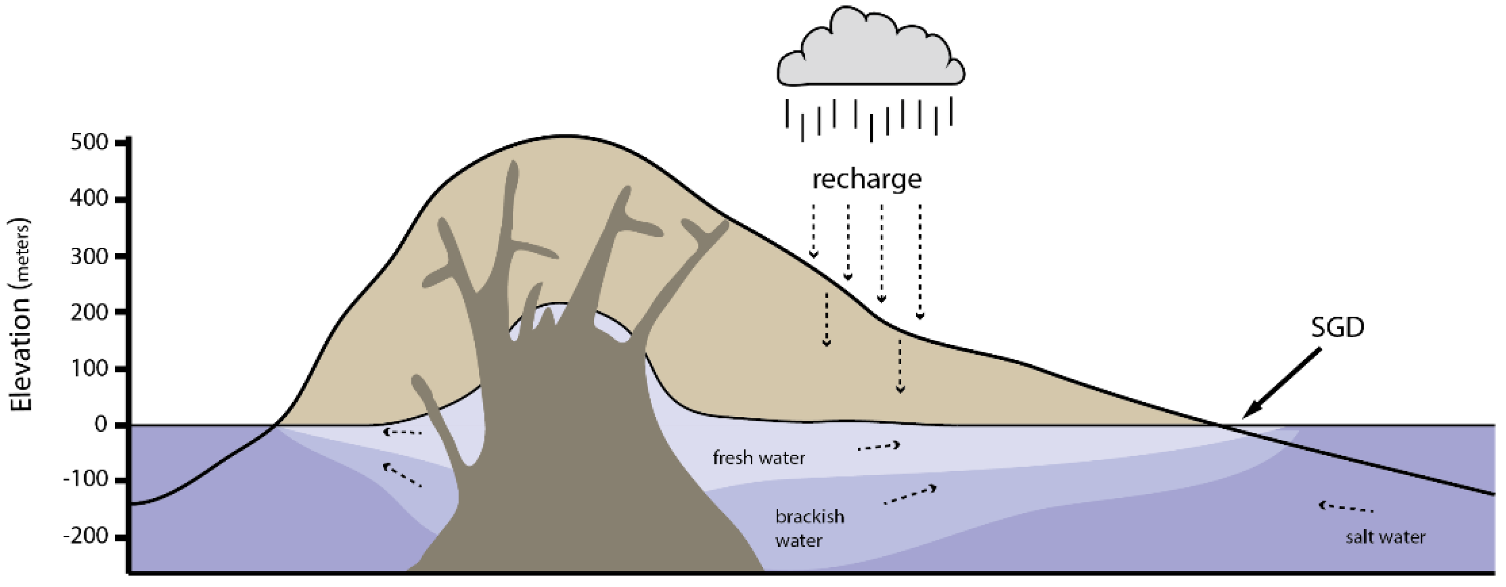
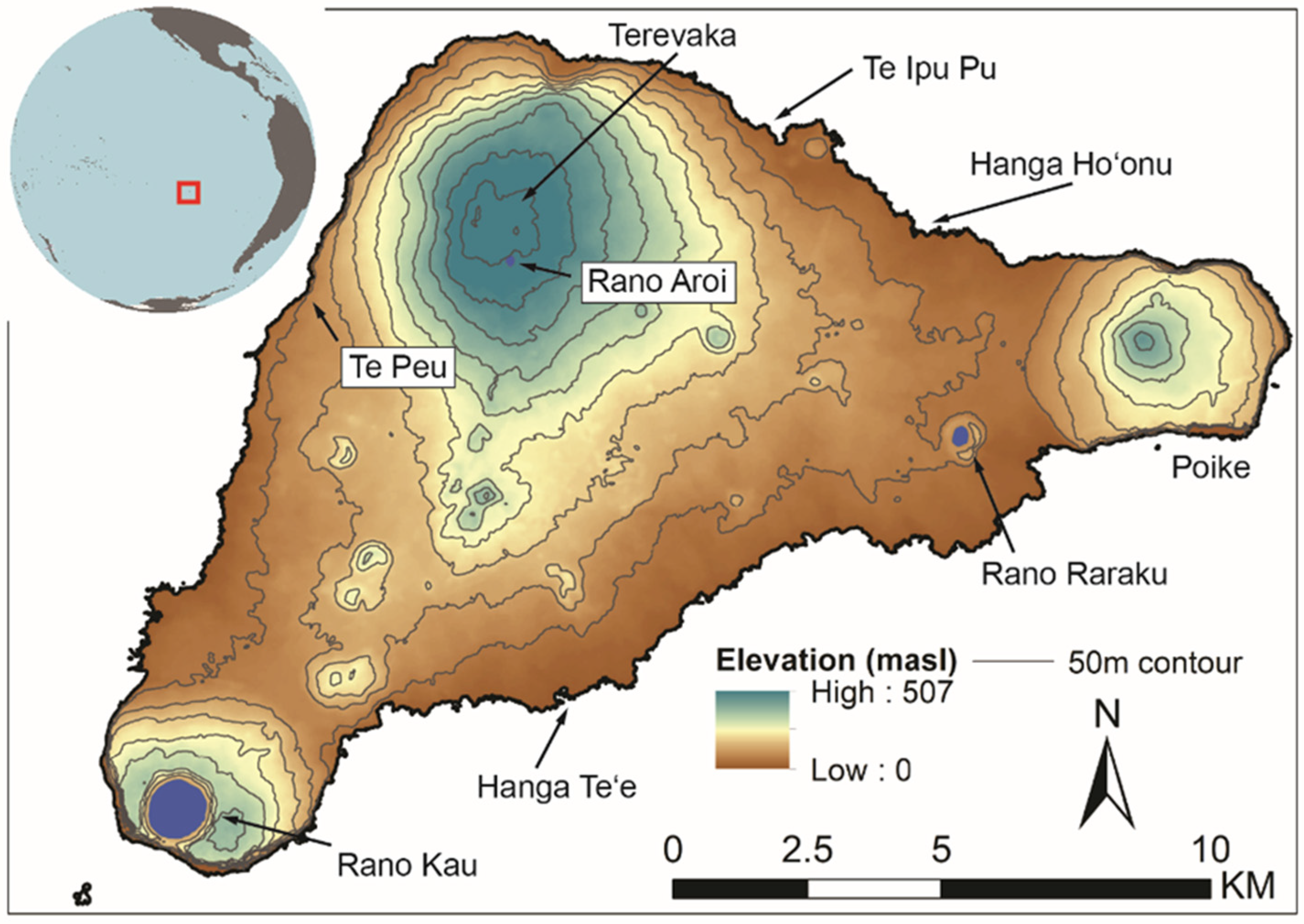
1.1. Rapa Nui Hydrogeology

Rapa Nui is a mid-plate volcanic high island situated at 27°07′ S, 109°27′ W, approximately 3700 km from South America. The island is relatively small (164 km2) and low in maximum elevation (~500 m asl), with a roughly triangular shape measuring roughly 23 km by 11 km in its longest dimensions. The island is composed of three main basaltic shield volcanoes (Maunga Terevaka, Rano Kau, Poike) and numerous smaller cinder, scoria and tuff cones, all of which are relatively young and range in age from ca. 0.78 to 0.11 Ma [20,21,22,23,24,25]. Terevaka forms the central dominant geologic feature, whose summit is the highest portion of the island at ca. 500 m asl. Poike forms the eastern point and is ca. 370 m asl with Rano Kau in the southwest corner at ca. 320 m asl. While coastal areas around Rano Kau, Poike and the northwestern coast of Terevaka are dominated by steep cliffs, the majority of the southwestern, northern and southern coasts are gently sloping.
The geology of the island is basaltic, composed mainly of hawaiites, basalts, mugearites, trachytes, and rhyolites [20,21,25,26]. These volcanic flows are highly permeable, and the existence and characteristics of a low-permeability volcanic core are poorly understood [20,27]. These geologic attributes result in an island with limited surface freshwater. The only persistent water bodies are three relatively small crater lakes. Rano Kau and Rano Raraku are precipitation-fed lakes, whereas Rano Aroi is also fed from a perched spring [27]. Rano Kau is the largest at ca. 1 km in diameter and ca. 6 m deep and is surrounded by steep slopes. Rano Raraku on the southeastern slopes of Terevaka is ca. 300 m in diameter and Rano Aroi near the Terevaka summit is ca. 200 m in diameter. Both Rano Raraku and Rano Aroi are shallow, with Rano Raraku periodically going dry and Rano Aroi frequently reverting to a bog during drought events (e.g., [28,29]). Both Rano Raraku and Rano Kau are believed to be closed basins, whereas Rano Aroi likely represents a dike-perched spring [20,27]. Except for short-lived and ephemeral surface runoff and overflow out of Rano Aroi, there are no permanent streams on the island.
Rainfall on Rapa Nui is seasonal and varies unpredictably between highs of ca. 2200 mm/year to lows of ca. 600 mm/year [30,31,32,33]. Annual mean precipitation is estimated to be around 2050–2200 mm/year at the summit of Terevaka and ca. 1000–1150 along the coast, and rain shadows on the western coast and western slopes of Poike result in values as low as 630–850 mm/year [33]. Analyses of historical rainfall patterns and climate proxies demonstrate high temporal variability from year to year with frequent drought events (e.g., [31,34]). The climate of the island is driven by a complex pattern of air masses, ocean dynamics, precipitation processes, air temperature factors and wind variability that are also intensified during strong El Niño-Southern Oscillation (ENSO) events [35]. With this combination of climate, permeability of the island surface, and evapotranspiration rates estimated at 850–950 mm/year [17,27], rainwater can be unpredictable and limited during most parts of the year.
Given the highly permeable surface, the majority of Rapa Nui’s fresh water exists in a fairly large groundwater aquifer fed by precipitation recharge [17,27] (Figure 2). While finer-scale spatial variability is poorly understood, water levels measured in a set of boreholes demonstrate that the water table is hundreds of meters deep near the center of the island and becomes shallower near the coast [27]. Based on data from field surveys and hydrological modeling, Herrera and Custodio [27] estimate recharge rates for the groundwater aquifer of ca. 300–400 mm/year along the coast and ca. 800 mm/year at high elevations of Terevaka. Except for the relatively small volume of freshwater pumped from wells by the island’s current population and some groundwater pooling in lava tubes, the vast majority of the island’s freshwater emerges along the coast as SGD [17,20,27]. This water is most accessible during low tide when the fresh water flows out as a thin Ghyben-Herzberg lens. These locations are not ubiquitous but depend on the permeability of the subsurface rock and sediments. Recent geochemical surveys around the southern and northeastern coast of Rapa Nui identified numerous SGD locations where salinity and conductivity values are significantly lower than surrounding seawater [15,17]. Based on their hydrological models, Herrera and Custodio [27] (p. 1346) estimate the total volume of SGD along the coast at 50–60 M m3/year and the turnover time of the island’s groundwater aquifer to be between 10–50 years. In summary, while surface freshwater is scarce, the available data indicate that fresh water is relatively plentiful in the groundwater aquifer.

1.2. Ancient Rapa Nui Water Management

Rapa Nui was initially settled by Polynesian voyagers around 1150–1280 cal AD [36,37,38,39]. Pre-contact populations grew to a maximum size of a few thousand individuals, who lived in relatively small, semi-autonomous, dispersed communities mostly around the coastline [31,40,41,42]. Over the course of human occupation, the island’s ecology was transformed from a palm forest to an anthropogenic landscape largely devoid of large stands of trees. The process of deforestation took centuries and was the cumulative result of land clearance for crop cultivation and the impacts of the invasive commensal Pacific rat (R. exulans) [43,44,45]. The present-day island is dominated by non-native grasses (Poaceae) with patches of non-native trees (e.g., Eucalyptus) planted in the 20th-century [46]. The island is most famous for the spectacular achievements of Rapa Nui people in megalithic construction, who over five centuries carved and transported hundreds of multi-ton stone statues (moai) that were erected on similarly massive platforms (ahu), which were the focal points of traditional settlements [36,47,48,49]. The achievements of the islanders are often contrasted with the limited natural resources on their small and isolated island, which has relatively poor soil nutrients, no large coral reefs or lagoons and, as discussed above, limited surface freshwater [50].
Archaeological research and ethnohistoric accounts document the use of a range of freshwater sources by Rapa Nui people [15,16,17,51]. Rainwater was collected in small (i.e., <1 m) carved stone basins called taheta. While taheta occur throughout the island, higher densities are found away from the coast on the interior slopes of Terevaka [31]. Analyses by Brosnan et al. [17] indicate taheta were unreliable as permanent water sources given rainfall variability and evapotranspiration rates. Traditionally, people also accessed drinking water that collected in caves, from a few inland springs, and at coastal seeps where SGD flows into the ocean. While surveyed coastal seeps are mildly to strongly brackish, archaeological and historical evidence demonstrates the use of water management techniques to trap or impound discharging groundwater prior to it mixing with seawater [16,17]. This is best documented through the construction of ‘wells’ known as puna, which are excavated, paved and sometimes walled features, that intersected the subsurface groundwater before it flowed into the ocean [16,17]. A series of European accounts collected in the 18th and 19th-centuries document cases where Rapa Nui people appeared to drink directly from the sea, likely at particularly concentrated SGD locations [16,17]. Moreover, analysis of freshwater diatoms extracted from dental calculus of pre-contact skeletal remains included many species that prefer brackish water [51,52].
Rapa Nui people also used inland water sources such as the crater lakes and places where fresh water could be impounded. A unique inland water feature occurs at Ava Ranga Uka a Toroke Hau, where Rapa Nui people constructed a relatively large stone-lined basin likely used to trap surface runoff and overflow from Rano Aroi [18,19]. Given the sparse evidence of settlements near this location, frequent droughts and high evapotranspiration rates, however, it is unlikely this location served as a long-term water source. Both Rano Kau and Rano Raraku were locations of agricultural activity (e.g., [53,54,55]), and notably, the summit of Rano Kau is the site of the post-contact ceremonial village of Orongo [56,57], and Rano Raraku was the quarry for the vast majority of moai statues [48]. Despite this evidence of ritual and agricultural activity, the crater lakes do not appear to have been primary sources of drinking water for most of the island’s population [16].
The vast majority of communities lived in coastal settlements in both pre-contact and early historic times, pointing to the fact that rainwater and especially coastal seeps served most communities as their primary source of drinking water [16,58]. Analyses of pre-contact settlement patterns support this conclusion (e.g., [15,31,59,60])—spatial modeling of the locations of ahu platforms, around which traditional communities were organized, shows a strong spatial association with SGD locations, which likely reflects intra-community cooperation and inter-community competition over these water sources [15,40,50]. While a few scholars doubt the dependability or preeminence of SGD as a key resource for Rapa Nui communities, especially during times of drought and on the northwest coast where steep cliffs potentially made the shoreline difficult to access (e.g., [61]), based on the coastal nature of ancient settlements and ethnohistoric information, SGD likely represented the only viable source of water for the vast majority of Rapa Nui’s human population [16,17]. While there is much archaeological, historical, and geochemical evidence for the location and use of SGD sources, however, we lack detailed characterizations of the amount of discharging groundwater at specific locations.

2. Materials and Methods
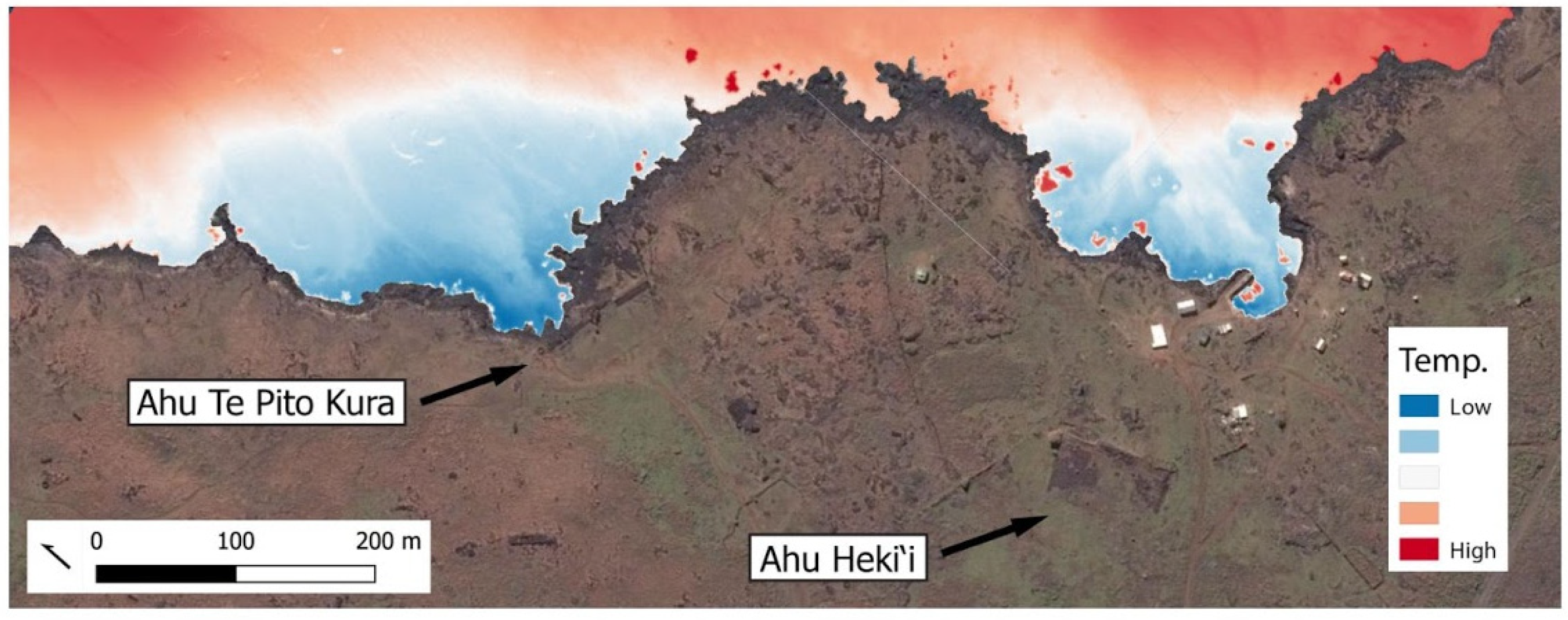
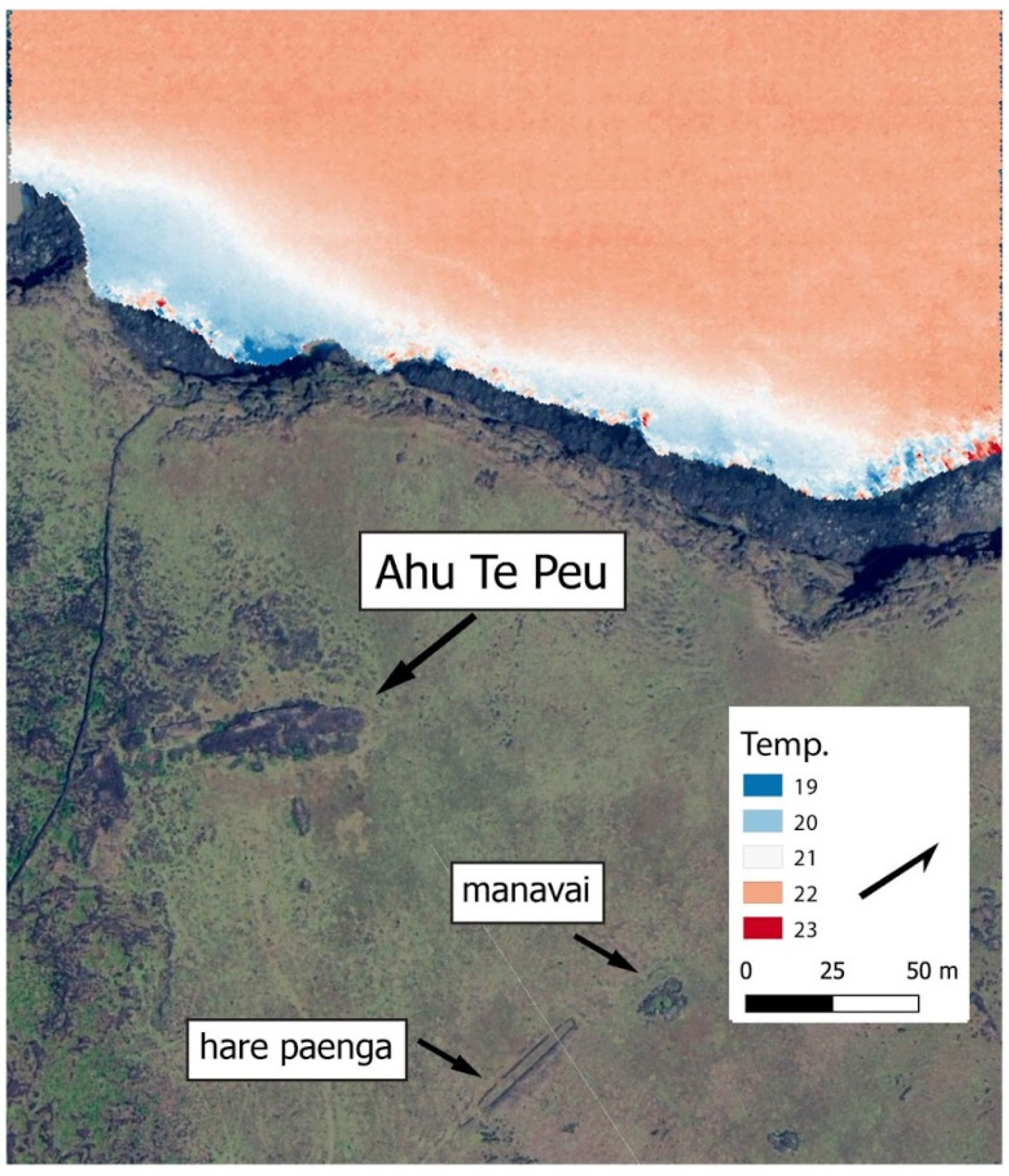
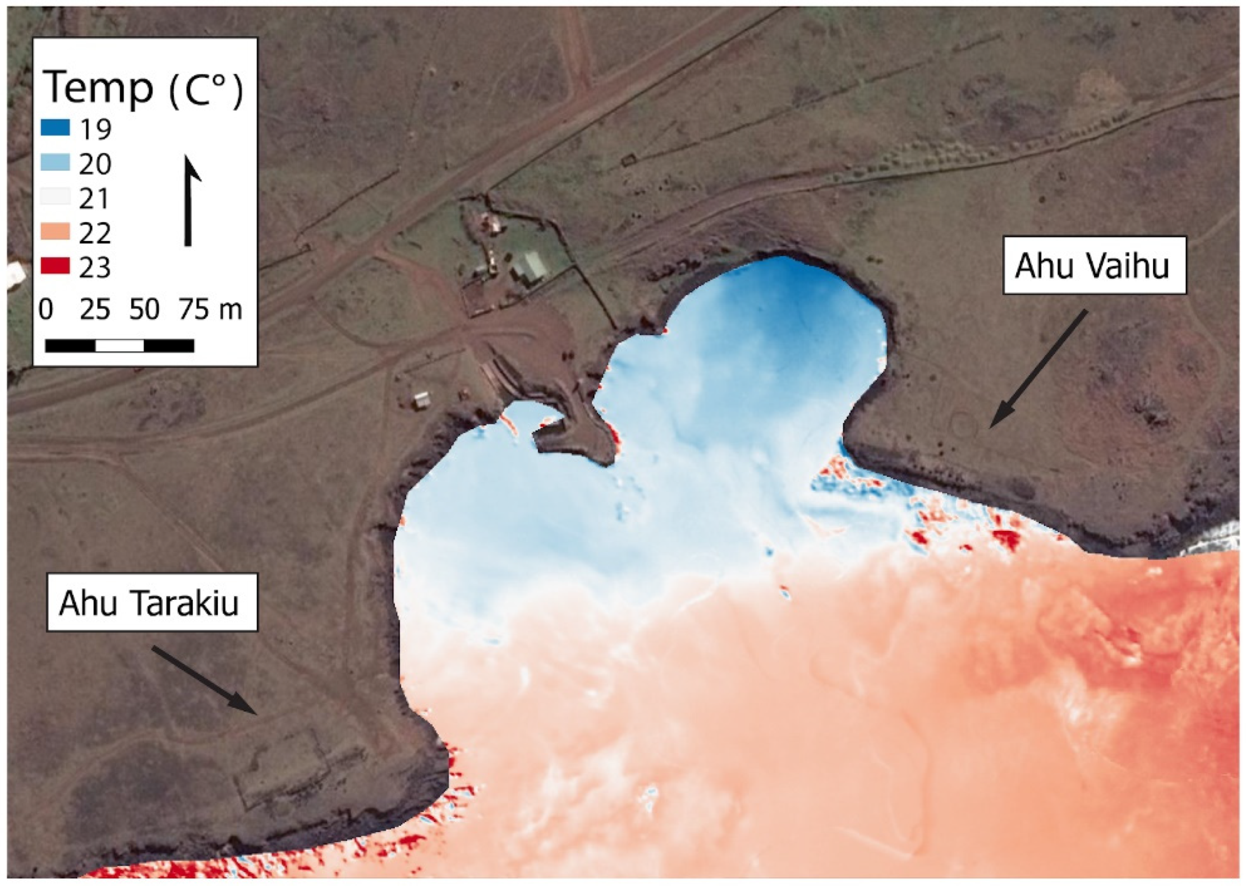
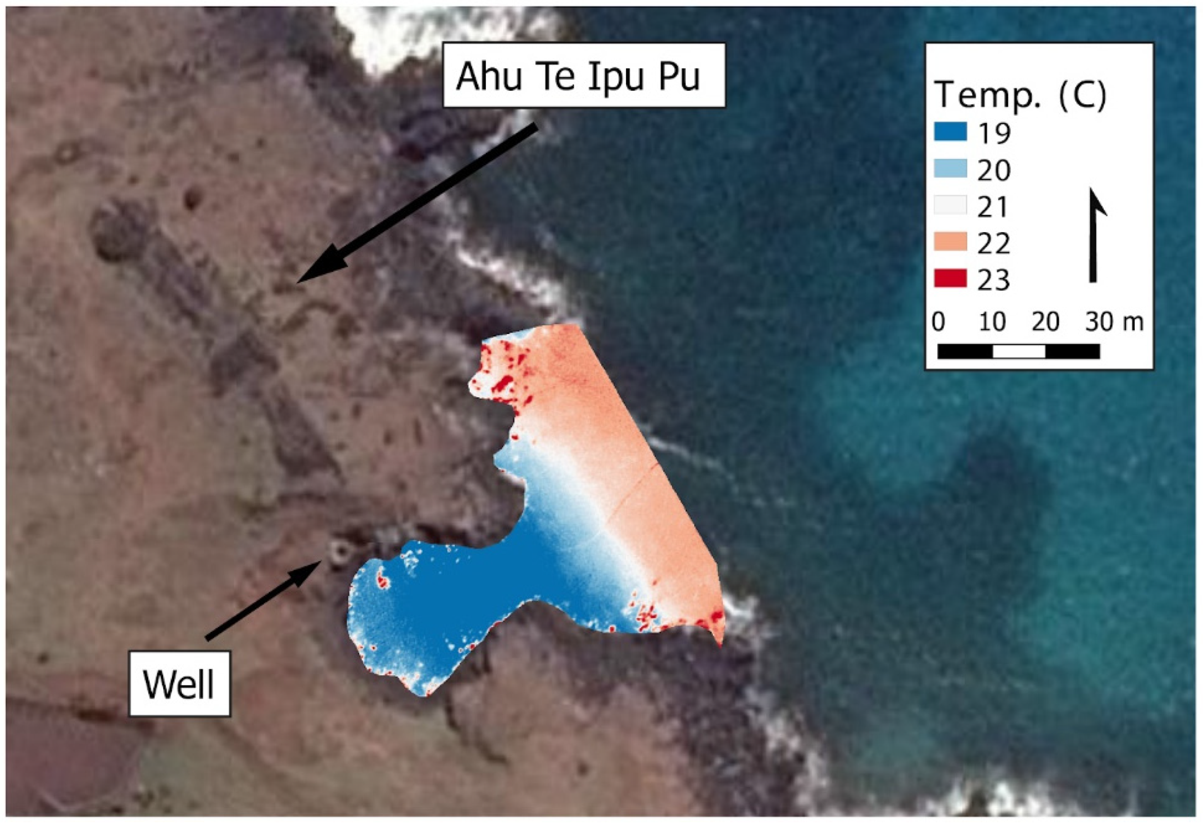
To map the locations and begin to document the relative amount of SGD around the island, between May and June 2019 we collected thermal infrared (TIR) imagery at four locations on Rapa Nui: (1) Hanga Te‘e on the south coast; (2) Te Ipu Pu; (3) areas adjacent to Hanga Ho‘onu and Te Pito Kura (also known as the La Perouse region) on the north coast; (4) near Ahu Te Peu located on the island’s northwest coast (Figure 1).
Thermal images were collected with FLIR Vue Pro R radiometric long-wave infrared (LWIR) sensor (640 × 512 pixel resolution) mounted with a TeAx ThermalCapture recording module and flown aboard a DJI Matrice 600 hexacopter. All images were captured with clear skies and relatively low wind speed. We post-processed the TIR imagery in ThermoViewer v.3.0.7. We compensated for a ‘cold corners’ effect using ThermoViewer’s motion-based non-uniformity correction (NUC) and drift compensation using flat-field correction (FFC) events. Individual frames were extracted from the raw data (TMC files) as radiometric RJPG files and processed into orthomosaics using Pix4D Desktop v4.5.6 thermal map workflow. Thermal rasters were exported as GeoTIFFs using Pix4D’s index calculator. Images were then clipped to the coastline in QGIS 3.14 using Google Earth imagery as a base map.
At Hanga Te‘e, Te Ipu Pu, and Hanga Ho‘onu, we measured water salinity using a Vernier salinity sensor attached to a Vernier LabQuest data logger. GPS points were collected at each sampling location using a Bad Elf GNSS Surveyor. Prior to each measurement session, we calibrated the salinity probe with a 35 ppt salinity calibration fluid. These measurements serve to verify the results of previous studies that identified significantly reduced salinity in these sampling locations [15,17]. We did not measure salinity at Te Peu due to the steep cliffs at this location.

3. Results

Figure 3, Figure 4, Figure 5 and Figure 6 show the thermal IR orthomosaics from Rapa Nui (see also Supplementary Information). Figure 3 shows Hanga Te‘e, with a concentrated area of cooler water (shown in blue) in the northeastern sector of the bay with increasing temperatures trending south-southwest towards the warmer open ocean (shown in red). The salinity measurements we generated along the shoreline support the interpretation that this cooler water is a result of SGD (see Appendix A). Salinity values in the eastern portion of the bay range from 3.7–11.6 ppt whereas the northwestern portion of the bay ranged from 16.2–21.3 ppt, and the southwestern portion was saline (ca. 34 ppt).
Figure 4 shows the area directly adjacent to Ahu Te Ipu Pu. The thermal data reveal the presence of a highly localized lens of cooler water that is emerging from the shore of this small bay. Salinity measurements taken from points along the shore confirm this cooler water reflects the presence of SGD, with salinity values within the bay as low as 2.8 ppt (values within the bay range from 2.8–10.2 ppt). Figure 4 also shows the location of a small modern well that is currently being used to pump water for horses.
Figure 5 shows areas adjacent to Hanga Ho‘onu, also known as the La Perouse region. In this location, we identified two localized lenses of cooler water, one directly adjacent to Ahu Te Pito Kura and another directly behind Ahu Heki‘i. While the images provide clear patterns of relative water temperature, the TIR data at this location were affected by the abundance of aluminum roofs and a bonfire that appeared in the camera’s initial imagery when we launched the UAS. The presence of aluminum, which has very low thermal emissivity but in this case was relatively warm, and very high emissivity fire caused the absolute temperature values to be inaccurately scaled. As a result, Figure 5 shows relative temperature differences. Despite challenges with the quantitative temperature measures, the images clearly show specific areas where relatively cooler groundwater water is discharging into the warmer ocean. Our salinity measurements from Hanga Ho‘onu bay (Appendix A) confirm that these cooler lenses of water are a result of seeping groundwater, with values as low as 3.4 ppt.
Figure 6 shows TIR imagery near Ahu Te Peu on the northwest coast. The thermal data show a relatively small area of cool groundwater seeping into the ocean directly below the steep cliffs adjacent to the ahu.

4. Discussion

Our results demonstrate that relatively inexpensive UAS with small thermal imagers provide a useful way of systematically exploring relatively small SGD locations. Hanga Te‘e is approximately 300 m across, Hanga Ho‘onu is ca. 190 m across, the seep directly below Te Peu is ca. 80 m across and the bay adjacent to Te Ipu Pu is only 25 m across.
Each of the SGD plumes reported here occur directly adjacent to ancient settlements. On either side of Hanga Te‘e (Figure 3) are two megalithic ahu platforms, with multiple moai (statues), Ahu Vaihu and Ahu Tarakiu. This location is also surrounded by archaeological settlement evidence, including domestic structures and gardens (e.g., [60,62,63]). In his early ethnographic work, Englert [58] (p. 221) notes the existence of a large water retention feature, now destroyed, within Hanga Te‘e that served to block fresh water from mixing with saltwater. The same pattern of association between ritual and domestic features and SGD occurs at Te Ipu Pu and Te Peu. A large house feature (hare paenga) and walled gardens (manavai) can be seen in the aerial imagery from Te Peu (Figure 6). The Hanga Ho‘onu region also has two impressive ahu, Ahu Heki‘i and Ahu Te Pito Kura, both surrounded by extensive human settlements. If we measure the surface area of the natural breakpoint in these SGD lenses, such as the line of approximately 20 °C at Vaihu, Te Peu, and Te Ipu Pu, the size of the lens at Vaihu is approximately 26,000 m2, Te Peu is ca. 2600 m2, and at Te Ipu Pu is ca. 1200 m2. Applying the same criteria, the area covered by the Heki’i lens is ca. 18,000 m2 and the lens behind Te Pito Kura is 32,000 m2.
It is interesting to note that Ahu Te Pito Kura is the location of the largest moai transported to an ahu as well as the largest pukao (red scoria ‘hat’). The moai is nearly 10 m tall and likely weighs about 80 tons. The pukao is equally impressive in size at 2 m tall and a possible weight of 11.5 tons [64]. Moreover, Heki‘i is one the largest ahu on the island (ca. 80 m long and 5 m tall), and is one of the few ahu with a robust radiocarbon chronology [65,66]. Bayesian chronological modeling indicates that Ahu Heki‘i was initially constructed between 1320–1445 cal. AD, as early as 70 years after the initial human settlement of Rapa Nui [36], and settlement pattern analyses demonstrate continuous occupation of the Hanga Ho‘onu region throughout the pre-contact and early historic period (e.g., [62,67,68,69,70]), strongly suggesting a long temporal association between domestic and ritual activity adjacent to this freshwater source.
While the locations of SGD along the southern and northern shoreline of Rapa Nui are relatively accessible, access to the sea along many parts of the island is difficult given substantial cliffs. Communities along the northwest coast, for example, were perched on cliff edges as much as 30 m above sea level. While there likely were ancient pathways that offered people access to the ocean, historic erosion due to sheep ranching combined with storm surge events has possibly obscured their presence. Present-day access to the sea is hazardous for exploration for fresh water using shore-based conductivity measures. Our UAS-based TIR surveys at one such location on the northwest coast—Te Peu—show the presence of fresh water emerging directly behind ahu features (Figure 6). In his discussion of the ethnohistoric and ethnographic evidence for use of coastal seeps, Métraux [59] (p. 11) noted, “Ruins of ancient settlements are always thick around water holes. The most famous are the water pools near Ahu-te-peu”. While the specific nature of these pools is somewhat ambiguous in Métraux’s account, our findings suggest this refers to SGD. Together, the ethnohistoric and remote sensing evidence suggest that SGD was likely accessible and used by communities in areas of the island with steep cliffs, such as the northwest coast, in addition to locations with easier coastal access (cf. [61]).
It is also important to note that these settlements are far from each of the crater lakes. Hanga Ho‘onu is ca. 4 km from Rano Raraku, ca. 7.5 km from Rano Aroi, and ca. 17 km from Rano Kau. Te Ipu Pu is ca. 5 km from Rano Aroi, 6.5 km from Rano Raraku, and ca. 16 km from Rano Kau. Vaihu is ca. 7 km from Rano Kau, 8.5 km from Rano Raraku, and ca. 8 km from Rano Aroi. Ahu Te Peu is ca. 4 km from Rano Aroi, ca. 9 km from Rano Kau, and ca. 12.5 km from Rano Raraku. These are straight-line distances not accounting for topography to be traversed if these lakes were the primary water sources for these communities, which would add significant travel time, especially to climb to the rim and descend into the crater lake at Rano Kau.
In 2014 and 2015, Brosnan et al. [17] documented that Rano Raraku held water though they were unable to confidently state whether the coastal seeps they identified were still active during drought events. An important finding of the present study is that our surveys were conducted while the island was experiencing a multi-year drought. Due to the drought, Rano Raraku and Rano Aroi were desiccated. While Rano Kau still held freshwater, water levels were several meters lower than those in recent islander memory. Figure 7 shows an image of Rano Raraku lake in May 2019 when the lake was nearly completely dry, a condition also noted by Sherwood et al. [55] during their 2018 fieldwork. These results indicate that during prolonged drought events, the crater lakes become dry before coastal groundwater locations. Our results support two previous claims: (1) Herrera and Custodio’s [27] estimate of a relatively long turnover time for the island’s groundwater aquifer ca. (10–50 years), and (2) the hypothesis proposed by Brosnan et al. [17] that SGD would have continued to serve as potential sources of freshwater for pre-contact Rapa Nui communities during times of drought.
Based on these results, we hypothesize that ancient Rapa Nui communities responded to the inherent and climate-induced hydrological challenges of the island by focusing on abundant and resilient SGD as freshwater sources. Future work should focus on building a radiocarbon chronology for the use of coastal freshwater management features (puna) used to trap and collect SGD. While ethnohistoric data and historical accounts confirm the use of the features at the time of initial European contact and into the historic period [16], we currently lack absolute chronological information on when they were initially constructed. Although we lack chronological information on these pre-contact freshwater management features, the settlements associated with them are relatively well-dated and show continuous occupation from early pre-contact times into the historic era (e.g., [31,36,60,68,71]).

5. Conclusions

Our results demonstrate the utility of UAS-based thermal imaging to provide rapid identification of SGD along the coast of Rapa Nui. These data add to a growing body of research indicating the importance of SGD as a source of fresh water for communities living on the island throughout its history. Despite the fact that we conducted these surveys during the Southern Hemisphere winter when the ocean temperature was the coldest and offshore wave action raised concerns about the viability of the technique, the differences in temperature in areas where groundwater emerged from the surface were clearly visible.
Future work will expand on these initial findings with the goal of systematically mapping the entire Rapa Nui coastline. We expect to be able to achieve improved results by conducting future surveys during the summer months when ocean temperatures are highest and the differences between saltwater and freshwater temperatures are the greatest. Future work will also acquire additional information from the identified locations of SGD including radium and radium isotopes in order to characterize the sources of groundwater and estimate discharge rates [1,72]. In this way, we will create spatially explicit SGD estimates for each sector of the island.
The preliminary results reported here suggest that Rapa Nui people’s reliance on SGD in pre-contact and early historic times may have been a response to the inherent and climate-induced water scarcity on the island. In the present time, climate change poses an existential challenge for islands such as Rapa Nui. These locations will be among the first to experience some of the most severe impacts that will come with a rising sea level, storm surges, and alterations to rainfall patterns—all of which affect the availability of freshwater. In addition, the demand for freshwater has grown significantly with the rapid increase in tourism and population on the island over the past 20 years [27]. Generating knowledge about the sources of fresh water, therefore, is central to long-term community sustainability. As has been demonstrated through work conducted in Hawai‘i [4], SGD may provide new and potentially more resilient sources of fresh water for islanders as they face future challenges with increased demand for water and a changing climate.

Supplementary Materials

Thermal images are available online at http://github.com/clipo/RapaNui_TIR/.

Author Contributions

Conceptualization, R.J.D. and C.P.L.; methodology, R.J.D., C.P.L. and T.S.d.S.; software, R.J.D., C.P.L. and T.S.d.S.; validation, R.J.D., C.P.L. and T.S.d.S.; formal analysis, R.J.D. and C.P.L.; investigation, R.J.D., C.P.L., T.S.d.S. and T.L.H.; resources, R.J.D., C.P.L., T.S.d.S. and T.L.H.; data curation, R.J.D., C.P.L. and T.S.d.S.; writing—original draft preparation, R.J.D. and C.P.L.; writing—review and editing, R.J.D., C.P.L., T.S.d.S. and T.L.H.; visualization, R.J.D.; supervision, R.J.D., C.P.L., T.S.d.S. and T.L.H.; project administration, R.J.D.; funding acquisition, R.J.D. and T.L.H. All authors have read and agreed to the published version of the manuscript.

Funding

This research was funded by the National Science Foundation grant number 1841420 to R.J.D. and T.L.H. and the American Philosophical Society’s Lewis and Clark Fund for Exploration and Field Research to R.J.D.

Institutional Review Board Statement

Not applicable.

Informed Consent Statement

Not applicable.

Data Availability Statement

Thermal imagery used in this study is available at http://github.com/clipo/RapaNui_TIR/, accessed on 6 June 2021. Salinity measurements are available in Appendix A.

Acknowledgments

This project was conducted in collaboration with Comunidad Indígena Polinésica Ma’u Henua, and we thank them for their support for this project and for all of their assistance with the fieldwork. Gina Pakarati and Hetereki Huke contributed significantly to the practical aspects of conducting these surveys and their efforts are greatly appreciated. The work in this project began with preliminary attempts to map freshwater using thermal cameras on Rapa Nui in 2014 with Chris Lee, Suzanne Wechsler, Matthew Becker and Tanya Brosnan from California State University Long Beach.

Conflicts of Interest

The authors declare no conflict of interest. The funders had no role in the design of the study; in the collection, analyses or interpretation of data; in the writing of the manuscript, or in the decision to publish the results.

Appendix A

Salinity values from study areas.
Table A1. Salinity values from study areas. Coordinates use WGS 1984 UTM Zone 12 S projection.
LocationSalinity (ppt) EastingNorthing
Hanga Te‘e *3.7662,1646,994,219
Hanga Te‘e *5.3662,2486,994,204
Hanga Te‘e *6.2662,2176,994,224
Hanga Te‘e *9.3662,2386,994,166
Hanga Te‘e11.6662,192.56,994,234
Hanga Te‘e16.2662,0356,994,140
Hanga Te‘e21.3662,011.96,994,112
Te Ipu Pu2.8665,982.77,004,547
Te Ipu Pu6.4665,982.67,004,550
Te Ipu Pu8.1666,003.57,004,557
Te Ipu Pu9.7665,995.87,004,530
Te Ipu Pu10.2666,020.67,004,545
Hanga Ho‘onu3.4668,728.97,002,617
Hanga Ho‘onu9668,732.97,002,616
Hanga Ho‘onu10.1668,712.97,002,644
Hanga Ho‘onu13.5668,740.97,002,614
Hanga Ho‘onu21.8668,710.97,002,638
Hanga Ho‘onu25.5668,6607,002,753
* Values also reported in [17].

References

  1. Taniguchi, M.; Dulai, H.; Burnett, K.M.; Santos, I.R.; Sugimoto, R.; Stieglitz, T.; Kim, G.; Moosdorf, N.; Burnett, W.C. Submarine Groundwater Discharge: Updates on Its Measurement Techniques, Geophysical Drivers, Magnitudes, and Effects. Front. Environ. Sci. 2019, 7, 141. [Google Scholar] [CrossRef]
  2. Rodellas, V.; Garcia-Orellana, J.; Masqué, P.; Feldman, M.; Weinstein, Y. Submarine Groundwater Discharge as a Major Source of Nutrients to the Mediterranean Sea. Proc. Natl. Acad. Sci. USA 2015, 112, 3926–3930. [Google Scholar] [CrossRef] [PubMed] [Green Version]
  3. Moore, W.S. The Effect of Submarine Groundwater Discharge on the Ocean. Annu. Rev. Mar. Sci. 2010, 2, 59–88. [Google Scholar] [CrossRef] [PubMed] [Green Version]
  4. Attias, E.; Thomas, D.; Sherman, D.; Ismail, K.; Constable, S. Marine Electrical Imaging Reveals Novel Freshwater Transport Mechanism in Hawai‘i. Sci. Adv. 2020, 6, eabd4866. [Google Scholar] [CrossRef] [PubMed]
  5. Burnett, W.C.; Aggarwal, P.K.; Aureli, A.; Bokuniewicz, H.; Cable, J.E.; Charette, M.A.; Kontar, E.; Krupa, S.; Kulkarni, K.M.; Loveless, A.; et al. Quantifying Submarine Groundwater Discharge in the Coastal Zone via Multiple Methods. Sci. Total Environ. 2006, 367, 498–543. [Google Scholar] [CrossRef]
  6. Mallast, U.; Schubert, M.; Schmidt, A.; Knoeller, K.; Stollberg, R.; Siebert, C.; Merz, R. Combination of Satellite Based Thermal Remote Sensing and in Situ Radon Measurements and Field Observations to Detect (Submarine) Groundwater Discharge. AGU Fall Meet. Abstr. 2012, 2012, H24C-06. [Google Scholar]
  7. Wilson, J.; Rocha, C. Regional Scale Assessment of Submarine Groundwater Discharge in Ireland Combining Medium Resolution Satellite Imagery and Geochemical Tracing Techniques. Remote Sens. Environ. 2012, 119, 21–34. [Google Scholar] [CrossRef]
  8. Casas-Mulet, R.; Pander, J.; Ryu, D.; Stewardson, M.J.; Geist, J. Unmanned Aerial Vehicle (UAV)-Based Thermal Infra-Red (TIR) and Optical Imagery Reveals Multi-Spatial Scale Controls of Cold-Water Areas Over a Groundwater-Dominated Riverscape. Front. Environ. Sci. 2020, 8, 64. [Google Scholar] [CrossRef]
  9. Lee, E.; Yoon, H.; Hyun, S.P.; Burnett, W.C.; Koh, D.-C.; Ha, K.; Kim, D.; Kim, Y.; Kang, K. Unmanned Aerial Vehicles (UAVs)-Based Thermal Infrared (TIR) Mapping, a Novel Approach to Assess Groundwater Discharge into the Coastal Zone. Limnol. Oceanogr. Methods 2016, 14, 725–735. [Google Scholar] [CrossRef]
  10. Dugdale, S.J.; Kelleher, C.A.; Malcolm, I.A.; Caldwell, S.; Hannah, D.M. Assessing the Potential of Drone-Based Thermal Infrared Imagery for Quantifying River Temperature Heterogeneity. Hydrol. Process. 2019, 33, 1152–1163. [Google Scholar] [CrossRef]
  11. Briggs, M.A.; Dawson, C.B.; Holmquist-Johnson, C.L.; Williams, K.H.; Lane, J.W. Efficient Hydrogeological Characterization of Remote Stream Corridors Using Drones. Hydrol. Process. 2019, 33, 316–319. [Google Scholar] [CrossRef] [Green Version]
  12. Young, K.S.R.; Pradhanang, S.M. Small Unmanned Aircraft (SUAS)-Deployed Thermal Infrared (TIR) Imaging for Environmental Surveys with Implications in Submarine Groundwater Discharge (SGD): Methods, Challenges, and Novel Opportunities. Remote Sens. 2021, 13, 1331. [Google Scholar] [CrossRef]
  13. Abolt, C.; Caldwell, T.; Wolaver, B.; Pai, H. Unmanned Aerial Vehicle-Based Monitoring of Groundwater Inputs to Surface Waters Using an Economical Thermal Infrared Camera. Opt. Eng. 2018, 57, 053113. [Google Scholar] [CrossRef]
  14. Ferrara, C.; Lega, M.; Fusco, G.; Bishop, P.; Endreny, T. Characterization of Terrestrial Discharges into Coastal Waters with Thermal Imagery from a Hierarchical Monitoring Program. Water 2017, 9, 500. [Google Scholar] [CrossRef]
  15. DiNapoli, R.J.; Lipo, C.P.; Brosnan, T.; Hunt, T.L.; Hixon, S.; Morrison, A.E.; Becker, M. Rapa Nui (Easter Island) Monument (Ahu) Locations Explained by Freshwater Sources. PLoS ONE 2019, 14, e0210409. [Google Scholar] [CrossRef]
  16. Hixon, S.; DiNapoli, R.J.; Lipo, C.P.; Hunt, T.L. The Ethnohistory of Freshwater Use on Rapa Nui (Easter Island, Chile). J. Polyn. Soc. 2019, 128, 163–189. [Google Scholar] [CrossRef]
  17. Brosnan, T.; Becker, M.W.; Lipo, C.P. Coastal Groundwater Discharge and the Ancient Inhabitants of Rapa Nui (Easter Island), Chile. Hydrogeol. J. 2019, 27, 519–534. [Google Scholar] [CrossRef]
  18. Vogt, B.; Moser, J. Ancient Rapanui Water Management—German Archaeological Investigations in Ava Ranga Uka A Toroke Hau. Rapa Nui J. 2010, 24, 18–26. [Google Scholar]
  19. Vogt, B.; Kühlem, A. By the Quebrada of Ava Ranga Uka A Toroke Hau—about landscape transformation and the significance of water and trees. In Cultural and Environmental Change on Rapa Nui; Haoa-Cardinali, S., Ingersoll, K.B., Ingersoll, D.W., Jr., Stevenson, C.M., Eds.; Routledge: New York, NY, USA, 2018; pp. 113–132. [Google Scholar]
  20. Bandy, M.C. Geology and Petrology of Easter Island. Bull. Geol. Soc. Am. 1937, 48, 1589–1610. [Google Scholar] [CrossRef]
  21. Baker, P.E.; Buckley, F.; Holland, J.G. Petrology and Geochemistry of Easter Island. Contrib. Mineral. Petrol. 1974, 44, 85–100. [Google Scholar] [CrossRef]
  22. Clark, J.G.; Dymond, J. Geochronology and Petrochemistry of Easter and Sala y Gomez Islands: Implications for the Origin of the Sala y Gomez Ridge. J. Volcanol. Geotherm. Res. 1977, 2, 29–48. [Google Scholar] [CrossRef]
  23. Miki, M.; Inokuchi, H.; Yamaguchi, S.; Matsuda, J.; Nagao, K.; Isezaki, N.; Yaskawa, K. Geomagnetic Paleosecular Variation in Easter Island, the Southeast Pacific. Phys. Earth Planet. Inter. 1998, 106, 93–101. [Google Scholar] [CrossRef]
  24. O’Connor, J.M.; Stoffers, P.; McWilliams, M.O. Time-Space Mapping of Easter Chain Volcanism. Earth Planet. Sci. Lett. 1995, 136, 197–212. [Google Scholar] [CrossRef]
  25. Vezzoli, L.; Acocella, V. Easter Island, SE Pacific: An End-Member Type of Hotspot Volcanism. Geol. Soc. Am. Bull. 2009, 121, 869–886. [Google Scholar] [CrossRef] [Green Version]
  26. Haase, K.M.; Stoffers, P.; Garbe-Schönberg, C.D. The Petrogenetic Evolution of Lavas from Easter Island and Neighbouring Seamounts, Near-Ridge Hotspot Volcanoes in the SE Pacific. J. Petrol. 1997, 38, 785–813. [Google Scholar] [CrossRef]
  27. Herrera, C.; Custodio, E. Conceptual Hydrogeological Model of Volcanic Easter Island (Chile) after Chemical and Isotopic Surveys. Hydrogeol. J. 2008, 16, 1329–1348. [Google Scholar] [CrossRef]
  28. Margalef, O.; Martínez Cortizas, A.; Kylander, M.; Pla-Rabes, S.; Cañellas-Boltà, N.; Pueyo, J.J.; Sáez, A.; Valero-Garcés, B.L.; Giralt, S. Environmental Processes in Rano Aroi (Easter Island) Peat Geochemistry Forced by Climate Variability during the Last 70 Kyr. Palaeogeogr. Palaeoclimatol. Palaeoecol. 2014, 414, 438–450. [Google Scholar] [CrossRef] [Green Version]
  29. Horrocks, M.; Baisden, W.T.; Harper, M.A.; Marra, M.; Flenley, J.; Feek, D.; Haoa-Cardinali, S.; Keller, E.D.; Nualart, L.G.; Gorman, T.E. A Plant Microfossil Record of Late Quaternary Environments and Human Activity from Rano Aroi and Surroundings, Easter Island. J. Paleolimnol. 2015, 54, 279–303. [Google Scholar] [CrossRef]
  30. Genz, J.; Hunt, T.L. El Nino/Southern Oscillation and Rapa Nui Prehistory. Rapa Nui J. 2003, 17, 7–14. [Google Scholar]
  31. Morrison, A. An Archaeological Analysis of Rapa Nui Settlement Structure: A Multi-Scalar Approach. Ph.D. Thesis, University of Hawaii, Manoa, Honolulu, HI, USA, 2012. [Google Scholar]
  32. Stevenson, C.M.; Puleston, C.O.; Vitousek, P.M.; Chadwick, O.A.; Haoa, S.; Ladefoged, T.N. Variation in Rapa Nui (Easter Island) Land Use Indicates Production and Population Peaks Prior to European Contact. Proc. Natl. Acad. Sci. USA 2015, 112, 1025–1030. [Google Scholar] [CrossRef] [Green Version]
  33. Puleston, C.O.; Ladefoged, T.N.; Haoa, S.; Chadwick, O.A.; Vitousek, P.M.; Stevenson, C.M. Rain, Sun, Soil, and Sweat: A Consideration of Population Limits on Rapa Nui (Easter Island) before European Contact. Front. Ecol. Evol. 2017, 5, 69. [Google Scholar] [CrossRef] [Green Version]
  34. Cañellas-Boltà, N.; Rull, V.; Sáez, A.; Margalef, O.; Bao, R.; Pla-Rabes, S.; Blaauw, M.; Valero-Garcés, B.; Giralt, S. Vegetation Changes and Human Settlement of Easter Island during the Last Millennia: A Multiproxy Study of the Lake Raraku Sediments. Quat. Sci. Rev. 2013, 72, 36–48. [Google Scholar] [CrossRef] [Green Version]
  35. Caviedes, C.N.; Waylen, P.R. Rapa Nui: A Climatically Constrained Island? Rapa Nui J. 2011, 25, 7–23. [Google Scholar]
  36. DiNapoli, R.J.; Rieth, T.M.; Lipo, C.P.; Hunt, T.L. A Model-Based Approach to the Tempo of “Collapse”: The Case of Rapa Nui (Easter Island). J. Archaeol. Sci. 2020, 116, 105094. [Google Scholar] [CrossRef] [Green Version]
  37. Hunt, T.L.; Lipo, C.P. Late Colonization of Easter Island. Science 2006, 311, 1603–1606. [Google Scholar] [CrossRef] [Green Version]
  38. Schmid, M.M.E.; Dugmore, A.J.; Foresta, L.; Newton, A.J.; Vésteinsson, O.; Wood, R. How 14C Dates on Wood Charcoal Increase Precision When Dating Colonization: The Examples of Iceland and Polynesia. Quat. Geochronol. 2018, 48, 64–71. [Google Scholar] [CrossRef] [Green Version]
  39. Wilmshurst, J.M.; Hunt, T.L.; Lipo, C.P.; Anderson, A.J. High-Precision Radiocarbon Dating Shows Recent and Rapid Initial Human Colonization of East Polynesia. Proc. Natl. Acad. Sci. USA 2011, 108, 1815–1820. [Google Scholar] [CrossRef] [Green Version]
  40. Hunt, T.L.; Lipo, C. The Archaeology of Rapa Nui (Easter Island). In The Oxford Handbook of Prehistoric Oceania; Cochrane, E.E., Hunt, T.L., Eds.; Oxford University Press: New York, NY, USA, 2018; pp. 416–449. [Google Scholar]
  41. Boersema, J.J.; Huele, R. Pondering the population numbers of Easter Island’s Past. In Easter Island and the Pacific: Cultural and Environmental Dynamics, Proceedings of the 9th International Conference on Easter Island and the Pacific, Held in the Ethnological Museum, Berlin, Germany, 21–26 June 2015; Vogt, B., Kühlem, A., Mieth, A., Bork, H.-R., Eds.; Rapa Nui Press: Hanga Roa, Chile, 2019; pp. 83–92. [Google Scholar]
  42. Lipo, C.P.; DiNapoli, R.J.; Madsen, M.E.; Hunt, T.L. Population Structure Drives Cultural Diversity in Finite Populations: A Hypothesis for Localized Community Patterns on Rapa Nui (Easter Island, Chile). PLoS ONE 2021, 16, e0250690. [Google Scholar] [CrossRef]
  43. Hunt, T.L. Rethinking Easter Island’s Ecological Catastrophe. J. Archaeol. Sci. 2007, 34, 485–502. [Google Scholar] [CrossRef]
  44. Hunt, T.L.; Lipo, C.P. The Human Transformation of Rapa Nui (Easter Island, Pacific Ocean). In Biodiversity and Societies in the Pacific Islands; Larrue, S., Ed.; Universitaires de Provence: Marseille, France, 2013; pp. 167–184. [Google Scholar]
  45. Rull, V. The Deforestation of Easter Island. Biol. Rev. 2020, 95, 124–141. [Google Scholar] [CrossRef]
  46. Finot, V.L.; Marticorena, C.; Marticorena, A.; Rojas, G.; Berrocal, J. Grasses (Poaceae) of Easter Island—Native and Introduced Species Diversity. In Biodiversity in Ecosystems: Linking Structure and Function; Blanco, J., Lo, Y.-H., Roy, S., Eds.; IntechOpen: London, UK, 2015; pp. 401–424. ISBN 978-953-51-2028-5. [Google Scholar]
  47. Martinsson-Wallin, H. Ahu—The Ceremonial Stone Structures of Easter Island; Societas Archaeologica Upsaliensis: Uppsala, Sweden, 1994. [Google Scholar]
  48. Van Tilburg, J.A. Easter Island: Archaeology, Ecology, and Culture; Smithsonian Institution Press: Washington, DC, USA, 1994. [Google Scholar]
  49. Lipo, C.P.; Hunt, T.L.; Haoa, S.R. The ‘Walking’Megalithic Statues (Moai) of Easter Island. J. Archaeol. Sci. 2013, 40, 2859–2866. [Google Scholar] [CrossRef]
  50. DiNapoli, R.J.; Morrison, A.E.; Lipo, C.P.; Hunt, T.L.; Lane, B.G. East Polynesian Islands as Models of Cultural Divergence: The Case of Rapa Nui and Rapa Iti. J. Isl. Coast. Archaeol. 2018, 13, 206–223. [Google Scholar] [CrossRef]
  51. Dudgeon, J.V.; Tromp, M. Diet, Geography and Drinking Water in Polynesia: Microfossil Research from Archaeological Human Dental Calculus, Rapa Nui (Easter Island). Int. J. Osteoarchaeol. 2014, 24, 634–648. [Google Scholar] [CrossRef]
  52. Cocquyt, C. Diatoms from Easter Island. Biol. Jaarb. Dodonaea 1991, 59, 109–124. [Google Scholar]
  53. Horrocks, M.; Baisden, W.T.; Flenley, J.; Feek, D.; Nualart, L.G.; Haoa-Cardinali, S.; Gorman, T.E. Fossil Plant Remains at Rano Raraku, Easter Island’s Statue Quarry: Evidence for Past Elevated Lake Level and Ancient Polynesian Agriculture. J. Paleolimnol. 2012, 48, 767–783. [Google Scholar] [CrossRef]
  54. Horrocks, M.; Baisden, W.T.; Nieuwoudt, M.K.; Flenley, J.; Feek, D.; Nualart, L.G.; Haoa-Cardinali, S.; Gorman, T.E. Microfossils of Polynesian Cultigens in Lake Sediment Cores from Rano Kau, Easter Island. J. Paleolimnol. 2012, 47, 185–204. [Google Scholar] [CrossRef]
  55. Sherwood, S.C.; Van Tilburg, J.A.; Barrier, C.R.; Horrocks, M.; Dunn, R.K.; Ramírez-Aliaga, J.M. New Excavations in Easter Island’s Statue Quarry: Soil Fertility, Site Formation and Chronology. J. Archaeol. Sci. 2019, 111, 104994. [Google Scholar] [CrossRef]
  56. Ferdon, E.N. The ceremonial site of Orongo. In Reports of the Norwegian Archaeological Expedition to Easter Island and the East Pacific Volume 1: Archaeology of Easter Island; Heyerdahl, T., Ferdon, E.N., Eds.; Forum Publishing House: Stockholm, Sweden, 1961; pp. 221–255. [Google Scholar]
  57. Robinson, T.; Stevenson, C.M. The Cult of the Birdman: Religious Change at ‘Orongo, Rapa Nui (Easter Island). J. Pac. Archaeol. 2017, 8, 88–102. [Google Scholar]
  58. Englert, S. La Tierra de Hotu Matu’a: Historia, Etnologia, y Lengua de Isla de Pascua; Padre Las Casas: San Francisco, CA, USA, 1948. [Google Scholar]
  59. Métraux, A. Ethnology of Easter Island; Bernice, P., Ed.; Bishop Museum Bulletin 160: Honolulu, HI, USA, 1940. [Google Scholar]
  60. McCoy, P.C. Easter Island Settlement Patterns in the Late Prehistoric and Protohistoric Periods; Easter Island Committee: New York, NY, USA, 1976. [Google Scholar]
  61. Rull, V. Drought, Freshwater Availability and Cultural Resilience on Easter Island (SE Pacific) during the Little Ice Age. Holocene 2020, 30, 774–780. [Google Scholar] [CrossRef]
  62. Vargas, V.C.; Ferrando, C.C.; Izaurieta, R. 1000 Años En Rapa Nui: Arqueología Del Asentamiento; Editorial Universitaria: Santiago, Chile, 2006. [Google Scholar]
  63. Ladefoged, T.N.; Flaws, A.; Stevenson, C.M. The Distribution of Rock Gardens on Rapa Nui (Easter Island) as Determined from Satellite Imagery. J. Archaeol. Sci. 2013, 40, 1203–1212. [Google Scholar] [CrossRef]
  64. Hixon, S.W.; Lipo, C.P.; McMorran, B.; Hunt, T.L. The Colossal Hats (Pukao) of Monumental Statues on Rapa Nui (Easter Island, Chile): Analyses of Pukao Variability, Transport, and Emplacement. J. Archaeol. Sci. 2018, 100, 148–157. [Google Scholar] [CrossRef]
  65. Martinsson-Wallin, H. Excavations at Ahu Heki’i, La Perouse, Easter Island. In Easter Island in Pacific Context: South Seas Symposium; Stevenson, C.M., Lee, G., Morin, F.J., Eds.; Bearsville Press: Los Osos, CA, USA, 1998; pp. 171–177. [Google Scholar]
  66. Martinsson-Wallin, H.; Wallin, P. Dating of Ahu Structures within the La Perouse Area. Rapa Nui J. 1998, 12, 85. [Google Scholar]
  67. Mulrooney, M. Continuity or Collapse? Diachronic Settlement and Land Use in Hanga Ho‘onu, Rapa Nui (Easter Island). Ph.D. Thesis, University of Auckland, Auckland, New Zealand, 2012. [Google Scholar]
  68. Mulrooney, M.A. An Island-Wide Assessment of the Chronology of Settlement and Land Use on Rapa Nui (Easter Island) Based on Radiocarbon Data. J. Archaeol. Sci. 2013, 40, 4377–4399. [Google Scholar] [CrossRef]
  69. Mulrooney, M.A.; Ladefoged, T.N.; Stevenson, C.; Haoa, S. The Myth of AD 1680: New Evidence from Hanga Ho’onu, Rapa Nui (Easter Island). Rapa Nui J. 2009, 23, 94–105. [Google Scholar]
  70. Stevenson, C.M.; Haoa-Cardinali, S. Prehistoric Rapa Nui: Landscape and Settlement Archaeology at Hanga Ho’onu; Easter Island Foundation: Los Osos, CA, USA, 2008. [Google Scholar]
  71. Stevenson, C.M. The socio-political structure of the southern coastal area of Easter Island: AD 1300-1864. In Island Societies: Archaeological Approaches to Evolution and Transformation; Kirch, P.V., Ed.; Cambridge University Press: Cambridge, UK, 1986; pp. 69–77. [Google Scholar]
  72. Kelly, J.L.; Dulai, H.; Glenn, C.R.; Lucey, P.G. Integration of Aerial Infrared Thermography and in Situ Radon-222 to Investigate Submarine Groundwater Discharge to Pearl Harbor, Hawaii, USA. Limnol. Oceanogr. 2019, 64, 238–257. [Google Scholar] [CrossRef] [Green Version]
Figure 1. Rapa Nui (Easter Island) with locations mentioned in the text.
Remotesensing 13 02531 g001
Figure 2. Rapa Nui hydrological model. Adapted with permission from ref [27]. Copyright© 2008, Springer-Verlag.
Remotesensing 13 02531 g002
Figure 3. Thermal image of submarine groundwater discharge at Hange Te‘e, showing the locations of two large ahu (ceremonial statue platforms), Ahu Vaihu and Ahu Tarakiu.
Remotesensing 13 02531 g003
Figure 4. Thermal image of submarine groundwater discharge at Te Ipu Pu, showing the locations of the ahu (ceremonial statue platform) and a modern well that is being used to pump groundwater out for livestock.
Remotesensing 13 02531 g004
Figure 5. Thermal image of submarine groundwater discharge in the Hanga Ho‘onu area, showing Ahu Heki‘i and Ahu Te Pito Kura.
Remotesensing 13 02531 g005
Figure 6. Thermal image of submarine groundwater discharge at Te Peu on the northwest coast.
Remotesensing 13 02531 g006
Figure 7. Rano Raraku crater lake, completely dry in May 2019.
Remotesensing 13 02531 g007
Publisher’s Note: MDPI stays neutral with regard to jurisdictional claims in published maps and institutional affiliations.

