Abstract
The territories between urban and rural areas, also called urban–rural fringe, commonly present inherent instability and notable heterogeneity. However, investigating the multifaceted urban–rural fringe phenomenon based on large-scale identification has yet to be undertaken. In this study, we adopted a handy clustering-based method by incorporating multidimensional urbanization indicators to understand how the urban–rural fringe development vary across space and shift over time in the Yangtze River Delta Urban Agglomeration, China. The results show that (1) the growth magnitude of urban–rural fringe areas was greater than urban areas, whereas their growth rate was remarkably lower. (2) The landscape dynamics of urban–rural fringe varied markedly between fast-developing and slow-developing cities. Peripheral sprawl, inter-urban bridge, and isolated growth were the representative development patterns of urban–rural fringe in this case. (3) Urban–rural fringe development has predominantly occurred where cultivated land is available, and significant inter-provincial differences and tendency shifts have been found in the land cover change processes therein. Our findings indicate that the urban–rural fringe development should be considered as a stage-dependent and place-specific process. This work extends previous knowledge by unraveling the diversity of urban–rural fringe in a fast urbanizing region, and can provide insights into reorienting the spatial planning and land use management within the urban–rural interface.
1. Introduction
Rapid urbanization has created vast areas of discontinuous and low-density development, commonly called peri-urban area or urban–rural fringe (URF), which are neither strictly urban nor rural [1]. In the past several decades, urban areas were substantially encroaching their territories to adjacent rural places. Such processes have resulted in land fragmentation, complex man-land nexus, and highly competing land use practices and demands [2]. More urban land is needed to accommodate urban population and anthropogenic activities [3]. Consequently, the peri-urban areas are expected to grow incessantly, even grow faster than urban areas in the future. In Europe, the projected growth rate of urban areas is lower than for peri-urban areas whose size is expected to double within 50 years [4]. In the context of an urbanizing planet, this trend requires more attention from both the policy and science community to deeply understand the dynamic nature and intricate pattern of the emergent periphery of megacities.
There is a growing consensus that the extant framework of the rural-urban dichotomy cannot adequately explain the blurring boundary between the urban and rural landscape. To unravel the intermediate characters of these territories-in-between, the URF is often conceptualized and identified as the buffer zone of the urban extent or specific administrative region located at the urban outskirts. The findings have been mounting on how the URF development reshapes the land use change [5,6], landscape composition [7], habitat integrity [8], hydrological cycle [9] and presents multiple land use conflicts, shortage of infrastructure and services, planning and management challenges in the URF [10,11,12,13]. Although these simplistic definitions substantially aid in a better understanding of the complexity along the urban–rural gradient, the multifaceted characteristics of URF themselves have been generally ignored. Besides, there is a dearth of notions for defining the typology of the suburb and exurb development, despite a wide range terminologies or definitions have been raised to identify the urban growth patterns [14,15].
Consistently, the distinctive characters of URF development have been described in terms of land use change, environmental impact, and socioeconomic dimensions [16,17]. These processes also varied across a great variety of spatial contexts or urbanization patterns. For instance, the spatial restructuring of URF in the developing world is deemed as an endogenous development driven by various factors such as rural industrialization and labor force migration [18], while URF development in western countries is usually associated with residents’ living and commuting preferences [19,20]. A recent review argued that peri-urbanization in Europe is a multifaceted process that can manifest itself differently in different case study areas [21]. However, the diverse reality of URF dynamics within developing countries is rather unknown. Particularly, following the far-reaching process of industrialization and economic globalization, spatial, socioeconomic, political transformation also commenced throughout the vast rural spaces in East and Southeast Asia [22]. Scholars referred to this process as rural urbanization or in situ urbanization [23,24], which prominently reconstructed the rural landscape and generated distinctive URF phenomenon (e.g., desakota) [25]. Characterizing the dynamics of such emergent URF areas would allow a greater understanding of the diverse forms of urbanization patterns in developing countries.
The URF identification via science-based technique still presents contestation, which is an important reason for the lack of knowledge of the heterogeneous URF development. For years researchers have attempted to demarcate the changing URF based on several qualitative and quantitative methods, whereas the former one generally relied on statistical data and empirical thresholds from scientists, which cannot avoid a degree of arbitrariness. To address such problems, remote sensing data including nighttime light images and Landsat data were extensively adopted to delineate the URF layout by using multi-criteria assessment [26], landscape index [27], mutation detection [28], wavelet transform [29], fuzzy membership function [30], and clustering algorithms [31]. The above techniques provided more accurate mapping results and have significantly contributed to a better understanding of the evolving nature of URF. Nevertheless, due to their common trait of ambiguity, there does not exist a generic method for accurate delineation of global peri-urban boundary and techniques for their demarcation should be local context-specific [32]. Therefore, it is of great importance to propose a suitable approach to identify the URF at regional or national scale, which can offer new opportunities to understand how the pattern and dynamic of URF vary across different socioeconomic contexts.
Overall, pre-existing studies of URF in the fast-urbanized regions mainly focused on a single metropolitan area, in-depth investigations conducted at a larger scale to discuss the regional disparities of URF areas have remained limited. The primary objective of this study is to extend previous knowledge on the diverse URF development by proposing a handy and feasible method to identify the URF of different cities in a rapidly urbanizing area and demonstrating their features. The Yangtze River Delta Urban Agglomeration (YRDUA) in China was selected as the study area, we attempted to examine spatial heterogeneity of URF development driven by diverse forms of urbanization. Specifically, this paper aims to: (1) develop a URF identification approach that is conveniently applicable at the regional scale, (2) investigate the spatiotemporal dynamics of URF and their variety between cities, (3) analyze the diverse trajectories of land cover changes within the URF areas between 2000 and 2020.
2. Materials and Methods
2.1. Study Area
The YRDUA is one of China’s most economically active, open and innovative regions, which covers Shanghai municipality and the provinces of Anhui, Jiangsu, Zhejiang (Figure 1). The entire region consists of 26 prefecture-level cities that cover an area of 211,700 km2. Following the YRDUA development plan approved by the State Council, the whole region is designed as an urban network including one core megacity (Shanghai) and five metropolitan circles (Nanjing, Hangzhou, Ningbo, Hefei, and Suzhou-Wuxi-Changzhou). By 2019, the gross domestic product (GDP) of the study area reached over 19.73 trillion yuan, and its population reached nearly 155.53 million, accounting for 20% and 11% of the national total, respectively. With an aggregate population and economic output, the YRDUA boasts strategic significance in the country’s modernization and further opening-up, making its regional integration crucial for leading China’s high-quality development.
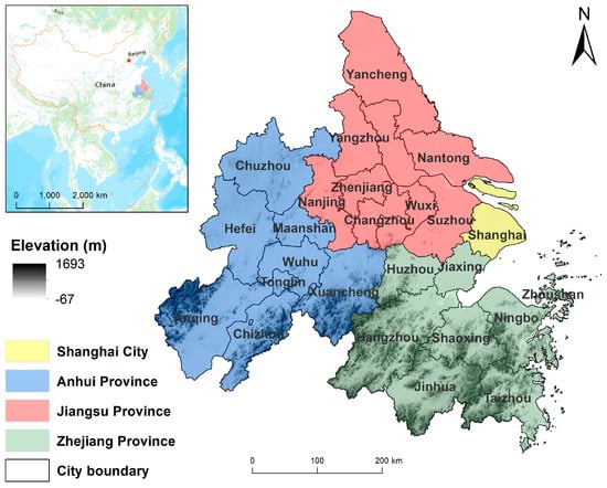
Figure 1.
Geographical setting of the YRDUA.
Since the Reform and Opening-up policy, unprecedented socio-economic development and urbanization have dramatically altered the urban–rural spatial structure and influenced the land use pattern in this region. In the past two decades, urban development in the city core has saturated and is continually spilling over to the suburbs and countryside of the YRDUA [33]. In the context of the national strategy to promote the development and regional integration of the Yangtze River Delta region, it is crucial to understand the diversity of the URF from a spatial agglomeration perspective.
2.2. Spatial Indicators of Urbanization
Population migration, land use change and human activities densification are the most reported traits of urban development in China. These fundamental characters along the urban–rural gradient can be reflected by multiple biophysical, demographic and socio-economic indicators. For instance, the impervious surface proportion, built-up land compactness and nighttime light (NTL) intensity would gradually decrease from urban center to rural hinterland, whereas the vegetation cover and agricultural land area may exhibit an increasing trend [34,35]. Aside from those most frequently used indicators, there are calls for integrating spatial topological relationships of land use patches such as inclusion and adjacency into distinguishing the fringe areas from urban and rural areas [36]. Hence, we selected three indicators, namely, population density (POP), NTL intensity, urban land compactness (LAND), to spatially portray multiple dimensions of urbanization, which help to identify the geographic extent of URF.
First, we calculated population density by dividing the count of people in each pixel cell by the pixel area. To ensure replicability of the proposed methodology to other geographic contexts, we obtained the spatial demographic data in 2000 and 2010 from the Unconstrained population UN adjusted count datasets (https://www.worldpop.org, accessed on 21 November 2020).
Second, we used NTL data as a proxy measurement to represent human activity intensity. Due to their advantages in containing a wealth of spatial information of anthropogenic activities, time-series DMSP/OLS imageries were extensively employed to identify the urban fringe areas [37,38]. However, the oversaturation and blooming effect of the original DMSP/OLS composite products have hindered these efforts from delimiting the URF accurately. In our work, a recent NTL dataset which outperforms the previous products because of its wider range of digital number [39], known as Global Radiance Calibrated Nighttime Lights, was selected to uncover the finer details from urban center to periphery. The NTL data of selected year were downloaded from the NOAA website (https://ngdc.noaa.gov/eog/dmsp/download_radcal.html, accessed on 21 November 2020). In addition, a linear regression model was set out to perform inter-annual calibration so that NTL data are comparable between different years [40].
Third, neighborhood analysis was adopted in this study to depict the spatial relationships among adjacent land use patches, thereby separating the low density scattered fringe area from continuous urban area. It could largely eliminate the misidentification of unlighted green spaces (e.g., parks, golf courses) that attached to urban activities into the non-urban type or some central villages with relatively higher light intensity as non-rural type. We analyzed the number of adjacencies between a given pixel with its neighboring urban land patches by the means of Focal Statistics tool based on the ArcGIS 10.5 platform, the neighborhood of the given pixel was set as a square with a width and height of 3 cells. The urban land patches in 2000 and 2010 was derived from the widely used China Land Use/Cover Dataset (CNLUCC) produced by the Institute of Resources and Environment, Chinese Academy of Sciences [41]. To integrate the abovementioned indicators, the geospatial datasets were all resampled to grid format with a cell size of 1 km2 which provided best fit scale for the spatial extent of the study area, then Z-score normalization was applied to standardize the values of the indicators.
2.3. Large-Scale URF Identification through Clustering Methods
In essence, the identification of URF based on the specific spatial characteristics along urban–rural gradient can be recognized as a spatial zoning process that goes beyond the urban–rural dichotomy. From a technical perspective, zoning is a clustering method that classifies the geographical units by maximizing the differences among each cluster. Numerous evidences have suggested that clustering algorithm can serve as a cost-effective analysis tool to processing a variety of spatial attributes and generate credible results for zoning decision-making [42,43]. Particularly, the k-means clustering method and Kohonen self-organized feature map (SOFM) neural network were usually used in the attempts to delineating the boundary of URF. However, as stated by in pervious study [36], delineating the inner and outer boundary of URF via SOFM clustering was entirely dependent on the empirical threshold values that are not applicable for other metropolitan areas. Therefore, identifying the spatial extent of URF at large scale requires a convenient approach that would not be sensitive to development stages or other place-specific features.
In this case study, we applied the k-means++ algorithm into classifying the regional rural-urban interface because this method takes advantage of its simplicity and robustness in processing multivariate datasets and improvements in seeding technique compare to the k-means method [44]. Unlike other unsupervised classification methods, this algorithm only requires a given number of clusters k without setting any other empirical knowledge-based parameters. Choosing an optimal cluster number k is an essential prerequisite for effectively classifying the spatial units. Given the research purpose, we iteratively conducted the clustering analysis with the minimum cluster numbers (k = 3). Then, we determined the optimal cluster number that fits with both the research aim and the regional context through the comparison and validation of different clustering results (Figure 2).
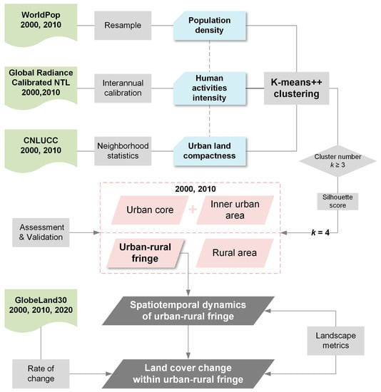
Figure 2.
Flowchart of the datasets and approaches employed in the present study.
We firstly calculated the silhouette score to assess the cohesion and separation of each cluster. For each observation point i, the formula of silhouette score Si can be expressed as [45]:
where ai denotes mean distance between the observation and all other intra-cluster points, bi indicates mean distance between the observation and all other data points of the nearest cluster. The value of Si ranges from −1 to 1, where a Si value close to 1 represents that the observation is well matched to its own cluster and poorly matched to neighboring clusters. The quality of different grouping results was then assessed according to the average silhouette score of all data points.
Although the silhouette score provides a succinct representation of how well each point has been categorized, the selection of optimal cluster number should take specific scientific need and local reality into account. Note that there is no widely accepted criterion to validate the extraction results of URF, we used the accuracy assessment of urban area derived from the clustering to indirectly verify the performance of our methods. The optimal cluster number k was then determined according to the consistency ratio (CR), which is calculated as:
where Ac is the total area of urban extent which obtained from the clusters, and Ar is the total area of referenced urban extent. Considering that this study defined the urban area by the dominance of physical attributes of land surface, we selected the urban extent products derived from the existed literature which employed the similar definitions as reference data, rather those impervious or artificial surface products.
2.4. Analysis of URF Dynamics and Land Cover Change
We calculated a series of landscape metrics to analyze the dynamics of URF (Table 1). Furthermore, we employed the GlobeLand30 dataset with 30 m spatial resolution [46], to investigate the land cover pattern and the land conversion process. We considered the land cover change as the direct impact of URF development, because of the high competing land use practices within the urban–rural interface. Thus, we analyzed the rate of land cover change for 2000–2010 and 2010–2020 within the URF extent of 2000 and 2010, respectively. GlobeLand30 includes 8 land cover classes in the study area, namely cultivated land, forest, grassland, shrubland, wetland, water bodies, artificial surface, bare land.

Table 1.
Landscape pattern metrics used in this study.
2.5. Validation and Accuracy Assessment
An iterative clustering process with a range of cluster number settings was firstly performed to generate intermediate results to determine the final URF boundary. We then preliminarily selected the optimal cluster number based on the silhouette score of each output. Figure 3 shows that the average silhouette score value gradually decreased when the cluster number k increased and the values tended to be convergent in both 2000 and 2010. In this regard, the trichotomy (k = 3) with the highest silhouette score has the best performance in clustering these spatial indicators. However, we found that this trichotomy was evidently not conforming with the ground truth through visual interpretation and comparison. Therefore, we set the optimal cluster number k as 4 for the demarcation of URF, as it provided a more credible classification.
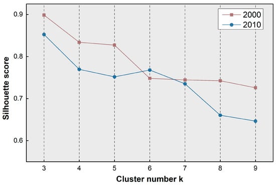
Figure 3.
The evaluation of silhouette score of each clustering output.
We further examined the plausibility of the demarcation of URF by comparing the derived total urban area with reference data at both prefecture city and regional level. We chose the China City Statistical Yearbook, GlobCover2009 [47], Atlas of Urban Expansion dataset [48] as reference data, because these datasets used similar definition of urban area. Three cities at different development stages (Shanghai, Hangzhou, and Anqing) were compared. Table 2 shows that our cluster-based method provides a reliable estimate of the urban area. The average CR of the whole region is 81.21% for 2000 and reaches 90.73% in 2010, which indicates that the derived urban area of this study shows a substantial agreement with the referential urban built-up area. Note that slow-developing city like Anqing shows a moderate agreement with other datasets, which mainly due to a number of built-up land patches of small-sized towns were identified as URF in these regions. Overall, the employed method is suitable for the large-scale URF identification.

Table 2.
Comparison of the total urban area (km2) of YRDUA obtained from the proposed method and the corresponding results from other references.
3. Results
3.1. Identification of the URF at Urban Agglomeration Scale
We divided the study area into urban core, inner urban area, URF and rural area based on the mean pixel value of three indicators in each cluster (Figure 4). The nighttime light intensity, urban land compactness and population density of these subclasses differed from one another and the indices significantly went up from urban periphery to centers. In addition, the increasing accumulated values of urban core, inner urban area and URF from 2000 to 2010 reflect that the YRDUA has experienced a rapid urbanization process, which is an expected finding. This also resulted in a drastic expansion of urban and their fringe areas, which formed a coastal urban corridor geographically connected by contiguous URF clusters.
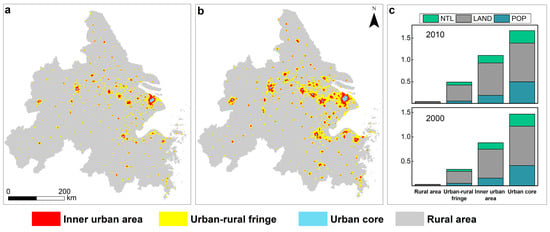
Figure 4.
The urban–rural classification of the YRDUA for (a) 2000 and (b) 2010, and (c) the average value of the three normalized indicators for each subclass.
With the urban areas exerted influences on more rural places, the boundaries of URF have radically extended throughout the study period, especially around Shanghai and the five metropolitan circles. Aside from these peripheral areas of metropolis, we also identified numerous discrete URF polygons, most of which are central towns and villages associated with the in situ urbanization process. Such dispersed pixels constituted a significant portion of URF areas in 2000, while the quantity of isolated small-scale URF patch were smaller in 2010.
3.2. Spatial-Temporal Variations of the URF
As is depicted in Figure 5, the expansion of URF was synchronized with urban growth across the study area, while the size of the delineated URF was varied markedly among different cities. As the regional growth pole, Shanghai took the leading position in its URF size initially, whereas it was transcended by Suzhou whose URF area sharply increased from 896 km2 to 2190 km2 in 2010. In contrast to the fast-developing cities of coastal regions, cities in Anhui Province have mostly experienced a relatively slow development of URF, and the gap between central cities and the rest has immensely widened in this decade. We also observed that the magnitude of URF growth was obviously greater than urban areas, while the growth rate of URF for most cities was lower than urban areas in the study area. Compared to the high speed of urban sprawl, URF area in the YRDUA have encroached on the countryside with a relatively lower speed. Besides, the area of URF is highly correlated with the urban area and GDP, which indicated that the economic growth and urban expansion posed a strong and positive impact on the URF growth in the YRDUA.
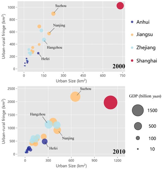
Figure 5.
The size of urban area and URF derived from this study for cities in the YRDUA.
Figure 6 displays the spatiotemporal patterns and conversion types between the subclasses of the urban–rural classification in the study area. The changed pixels were mainly distributed at the periphery area of coastal cities with higher development level. Nearly a half of urban areas were transformed from the URF from 2000 to 2010, suggesting that the majority of urban growth occurred in the URF. What remained unchanged were those dispersedly distributed URF patches with smaller size. This type of URF barely transformed into urban area, and only show a slight incremental change. Rural urbanization is an important driving force of these isolated URF areas, but it cannot drastically alter the rural landscape into densely built area.
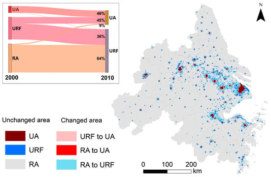
Figure 6.
Spatial variations and transitions of urban area (UA), URF, and rural area (RA) from 2000 to 2010.
Besides, a small proportion of undeveloped rural areas that near the early urban extent was directly converted into urban area, exhibited as spatial leapfrogging pattern, accounting for 9% of the total urban area. As the frontier of URF growth, the transformation from rural areas contributed to 64% of the total area of URF in 2010. These numbers depicted that most of the changed areas in the YRDUA sequentially underwent urban expansion or urban fringe development which is characterized by transitions from rural area into URF initially and then gradually transformed to inner urban area.
The landscape metrics for 2000 and 2010 provided detailed spatial information of URF landscape dynamics (Table 3). The URF patches were mainly distributed in southern Jiangsu Province, which had the largest TA and NP. Shanghai, Jiangsu and Zhejiang had relatively similar trends of notable URF expansion and aggregation, as evidenced by the nearly double total area, slight variation of URF patches number, increasing aggregation index and decreasing mean nearest-neighbor distance over the period. The URF dynamics of Anhui Province was different from the other province which reflected by the slightly increasing TA and AI. It can be found that the fringe development resulted in the clumped URF area of the coastal regions, but the unusual increase in ENN_MN value (from 15.35 to 16.51) suggests that the spatial patterns of URF in Anhui Province remained scattered and dispersed. The LPI maintained an upward trend across the whole study area, indicating that the sprawl of the largest URF patches was the dominating characteristic of peri-urban dynamics. Shanghai had a much higher value of LPI than other cities, which is due to the large and compact built-up area. Most of disaggregated small-scale urban fringe patches tended to clump together to form a contiguous peri-urban agglomeration, especially in the Suzhou-Wuxi-Changzhou metropolitan circles.

Table 3.
Landscape pattern metrics of URF for 2000 and 2010.
3.3. Land Cover Dynamics in the URF
Table 4 presents the spatial pattern characteristics of different land cover types in the URF. The vast majority of the URF areas were covered by cultivated land and artificial surfaces whose PLAND exceed other land cover types by a wide margin. Forest, grassland and water bodies constituted less percentage of the whole landscape, but with high patch density, which suggests the small-scale patch distribution for the types. There are notable differences in land cover patterns in the URF between 2000 and 2010 at the whole region level. On the one hand, the URF of 2010 covered by larger area of artificial surface, grassland and less cultivated land, forest. On the other hand, the dominant land coverages in 2010 were more aggregated accompanied by more regular landscape shape, as reported by their decreasing PD, SHAPE_MN value and increasing AI value, except that forests were more fragmented and dispersed in 2010.

Table 4.
Landscape pattern metrics for each land cover type in the URF.
The land cover conversion within the URF boundary also varied significantly across time and space. Note that the peri-urban landscapes in the study area were dominated by the cultivated land and artificial surface. Hence, this paper concentrated on cultivated land, artificial surface and green space (the combination of forest, grassland, shrubland).
The land cover dynamics of URF were mainly characterized by a high change percentage of cultivated land and artificial surface (Figure 7). Although URF in Anhui Province experienced a higher rate of green space change, the majority in other provinces exhibited a proportional relationship between cultivated land loss and artificial surface growth along with a very low rate of green space change in the peri-urban areas over the entire study period. This finding illustrated that urbanization-associated artificial surface expansion is highly correlated with the farmland loss in the URF areas. The green space dynamics in the URF also differed markedly between cities, the large area occupations of forest and shrubland mostly occurred in cities of Anhui over the whole period, while the variation in green space in the other cities remained stable and slight. Particularly, the largest green space growth of 4.16% was detected in Shanghai for 2010–2020.
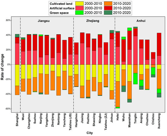
Figure 7.
Change rate of three land cover types within the URF for 25 cities during 2000 to 2020 (Note: Zhoushan were not drawn in the figure due to the results were incomparable which related to its unique island features).
For the land cover change trajectory between the two periods, this proportional conversion between cultivated land and artificial surface demonstrated obvious inter-provincial differences and intra-provincial similarities. For instance, artificial surface growth rate of URF in Shanghai (25.54%) from 2000 to 2010 was much higher than the subsequent period (7.98%), and its absolute value of change ratio of cultivated land decreased from 28.87% to 12.30%. The rates of land cover changes for Zhejiang Province also presented a moderate tendency shift from high change rates to relatively lower rates, except Hangzhou and Taizhou were relatively steady and consistent for the two time periods. In contrast, the rate of artificial surface change for the URF of Jiangsu Province greatly increased (range from 16.32% to 28.57%) in 2010–2020 compared to the previous period (range from 6.98% to 16.22%). There is no obvious pattern for Anhui Province in that the land cover change ratio varied strongly across different cities.
4. Discussion
4.1. Insights for Typology of URF Development
In this study, we differentiated the URF via a number of structural features including physical attributes and population distribution. The presented urban–rural classification outperformed the prevalent urban–rural dichotomy in mapping the complex spatial structure of urbanized areas on a regional scale. The different types of URF development in the study area can be determined from the perspective of changes in spatial structure. As displayed in Figure 8, we identified three subcategories of URF development patterns: peripheral sprawl, inter-urban bridge, isolated growth.
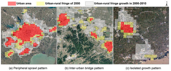
Figure 8.
Three typical spatial patterns of URF development located at (a) Hefei, (b) border between Hangzhou and Shaoxing, (c) coastal area of Jiaxing.
Peripheral sprawl represents an expansion of the existing compact urban fringe patch, which are generally located around the highly urbanized area. The peripheral sprawl pattern has become the dominant feature of urban outskirt changes in the study area. The inter-urban bridge pattern is the cross-boundary URF growth that spatially interconnects two or more urban areas, which results in a contiguous and dense fringe development. This pattern occurred in the areas where geographical proximity between cities was found, mainly presented a linear growth or ribbon development fashion, and could be largely attributed to industrial transfer and transport network construction in the context of regional integration and development. Isolated growth pattern describes the expansion of URF, which is some distance from the metropolitan area and surrounded by undeveloped rural areas. This class of growth pattern is characterized by small-scale and low-density development, mostly distributed in a number of emerging satellite towns and central villages driven by rural urbanization. Besides, isolated URF growth was also observed in the coastal port areas, which are associated with the change in administrative division and planning orientations.
As a whole, it can be concluded that the URF areas are generally molded by their adjacent metropolis at the primary stage based on the empirical results in the YRDUA. When the urbanization form evolves into a polycentric structure, the diversity of URF development patterns would immensely reshape the spatial nature of the urban agglomeration. We argued that the URF development pattern should be understood as a place-specific process within different spatial contexts, and a more nuanced classification is a crucial step towards comprehensive understanding of the transformation from urban–rural divide to urban–rural integration. The above structure-based category for URF development can extend the knowledge of existed typology of urban growth pattern, which helps to explicitly detect the potential space and future direction of urban development for planners and decision-makers.
4.2. Implications for Land Use Practices in URF
Our findings underpin previous arguments by highlighting how the patterns and dynamics of URF land cover varied under different development background. Beyond the configuration and composition of land surface, the varying degrees of land use intensity were found within different urban–rural interfaces. For example, we found that human activity intensifies as the size of URF increases, while the proportion of the artificial surface is not entirely correlated with the development level in 2010 (Figure 9). In particular, higher intensity of anthropogenic activity accompanied by a lower share of artificial surface was found in some metropolises like Suzhou and Nanjing, which manifest a land-use intensification in the URF areas. Conversely, the fringe areas covered by a higher share of built-up land but with less human activity are generally related to the extensive outwards sprawl of urban areas.
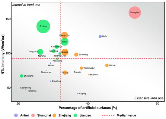
Figure 9.
The average value of NTL intensity and percentage of artificial surface of the URF in 2010, the bubble size represents the URF area.
In this regard, the extensive growth of built-up areas within the limited space of URF could not only constrain the land use efficiency but also undermine the multifunctional use of the peri-urban landscape and affect its capability to meet social demands on ecosystem services (e.g., food production, recreation). Hence, restraining the densification of built-up land induced by UFR development through policy instruments should be put high on the agendas of urban management actions. Our study reported that the megacity Shanghai has notably decelerated the extensive growth of artificial surface and restored considerable green space in the URF, which can be attributed to the implementation of a series of policy instruments such as the industrial land reduction outside the Urban Development Boundary (UDB), and country park construction [49,50,51]. The evidence from Shanghai suggests that an important step towards sustainable URF development is to establish a clear and stable governance structure within and beyond the urban–rural interface.
Taken together, being highly dynamic in nature, and under significant pressure from urban expansion, the URF development generally presents particular challenges for spatial planning and land use practices. We should acknowledge that the competing demands in such areas also provide opportunities for adaptive land use management. Restricting the unwanted urban sprawl and promoting the intensive-use of developed land allows for more space to ensure the flexibility and multifunctionality of the URF area. For policy-makers, taking proactive land use management and planning actions prior to the exploitation of urban fringe areas can effectively mitigate the conflicts of interest between different stakeholders and then advance urban sustainability.
4.3. Limitation and Further Research Outlook
By incorporating cluster algorithms and various remote sensed and spatial data, the proposed methodology offers an effective and time-saving way for URF identification at the macro level, especially for the regions where differences in geographic context and development stage are expected. However, due to their limited availability and coarse spatial resolution, the selected datasets may hinder the methods of this work from the application in a longer time span and global context. The harmonized and consistent NTL dataset derived from different satellites (e.g., DMSP/OLS, Suomi-NPP, Luojia-01) needs to be introduced to monitor the long-term URF dynamics, and other more recent global landcover data can be used to evaluate the robustness in further research.
Given that the peri-urban contexts mainly differ in two fundamental way: structural and functional [52,53], the URF dynamics can be categorized according to their structural and functional changes. The URF identification was conducted based on the perspective of spatial structure in this study, while the functional structure has not been integrated into the methodological framework. Although there are still hurdles regarding explore the diverse functions of the peri-urban landscape at a large scale [12,54], the machine learning methods combined with urban big data, environment data have a great potential in defining the multifunctionality in the URF areas, thus can be adopted in the future studies.
5. Conclusions
This study aims to improve our understanding of the diversity of URF development in a fast-urbanized region. By applying a clustering algorithm and adopting three parameters that imply important dimensions of urbanization, we offer a cost-effective way of identifying the development patterns of the URF at the regional scale. The main findings from the case study in YRDUA show that the vast majority of newly urbanized areas were transformed from the URF in close proximity to the metropolitan area, and the growth rate of the URF is lower than for urban expansion. The temporal evolution of spatial extent and landscape pattern of the URF vary markedly across different cities, suggesting that the URF development can be recognized as a place-specific and stage-dependent process. Moreover, the expansion of built-up land has occurred predominantly on cultivated land where available, and notable inter-provincial differences have been found in the land cover change trajectories within the URF boundary. It can be argued that investigating the URF development through the lens of human influence and dominance of developed land can provide insights into reorienting the urban planning and management, thereby reframing the current undefined governance within the urban–rural interface.
Author Contributions
Conceptualization, methodology, formal analysis, writing—original draft, G.L.; software, J.H. and Y.C. (Yu Cao); visualization, X.F. and J.W.; writing—review and editing, Z.H.; conceptualization, writing—review and editing, supervision, funding acquisition, Y.C. (Yu CAO). All authors have read and agreed to the published version of the manuscript.
Funding
This research was financially supported by the Key Project of the National Social Science Fund of China (No. 20AGL025).
Data Availability Statement
The employed remote sensing data are openly available from the corresponding website and the processed data are available upon request.
Acknowledgments
Support by the Key Project of the National Social Science Fund of China (20AGL025) are acknowledged. The authors would like to express great appreciation to NOAA National Centers for Environmental Information and WorldPop project for their data sharing platforms. We thank three anonymous reviewers for their time and effort in reviewing the manuscript.
Conflicts of Interest
The authors declare no conflict of interest.
References
- Seto, K.C.; Reenberg, A.; Boone, C.G.; Fragkias, M.; Haase, D.; Langanke, T.; Marcotullio, P.; Munroe, D.K.; Olah, B.; Simon, D. Urban land teleconnections and sustainability. Proc. Natl. Acad. Sci. USA 2012, 109, 7687–7692. [Google Scholar] [CrossRef]
- Van Vliet, J. Direct and indirect loss of natural area from urban expansion. Nat. Sustain. 2019, 2, 755–763. [Google Scholar] [CrossRef]
- Bren d’Amour, C.; Reitsma, F.; Baiocchi, G.; Barthel, S.; Güneralp, B.; Erb, K.-H.; Haberl, H.; Creutzig, F.; Seto, K.C. Future urban land expansion and implications for global croplands. Proc. Natl. Acad. Sci. USA 2017, 114, 8939. [Google Scholar] [CrossRef] [PubMed]
- Piorr, A. Peri-Urbanisation in Europe: Towards European Policies to Sustain. Urban-Rural Futures: Synthesis Report; Forest & Landscape, University of Copenhagen: Copenhagen, Denmark, 2011. [Google Scholar]
- Smiraglia, D.; Ceccarelli, T.; Bajocco, S.; Perini, L.; Salvati, L. Unraveling Landscape Complexity: Land Use/Land Cover Changes and Landscape Pattern Dynamics (1954–2008) in Contrasting Peri-Urban and Agro-Forest Regions of Northern Italy. Environ. Manag. 2015, 56, 916–932. [Google Scholar] [CrossRef] [PubMed]
- Gant, R.L.; Robinson, G.M.; Fazal, S. Land-use change in the ‘edgelands’: Policies and pressures in London’s rural–urban fringe. Land Use Policy 2011, 28, 266–279. [Google Scholar] [CrossRef]
- Guo, L.; Di, L.; Tian, Q. Detecting spatio-temporal changes of arable land and construction land in the Beijing-Tianjin corridor during 2000–2015. J. Geogr. Sci. 2019, 29, 702–718. [Google Scholar] [CrossRef]
- Bauer, D.M.; Swallow, S.K. Conserving metapopulations in human-altered landscapes at the urban–rural fringe. Ecol. Econ. 2013, 95, 159–170. [Google Scholar] [CrossRef]
- Danielaini, T.T.; Maheshwari, B.; Hagare, D. Defining rural–urban interfaces for understanding ecohydrological processes in West Java, Indonesia: Part II. Its application to quantify rural–urban interface ecohydrology. Ecohydrol. Hydrobiol. 2018, 18, 37–51. [Google Scholar] [CrossRef]
- Scott, A.J.; Carter, C.; Reed, M.R.; Larkham, P.; Adams, D.; Morton, N.; Waters, R.; Collier, D.; Crean, C.; Curzon, R.; et al. Disintegrated development at the rural–urban fringe: Re-connecting spatial planning theory and practice. Prog. Plan. 2013, 83, 1–52. [Google Scholar] [CrossRef]
- López-Goyburu, P.; García-Montero, L.G. The urban–rural interface as an area with characteristics of its own in urban planning: A review. Sustain. Cities Soc. 2018, 43, 157–165. [Google Scholar] [CrossRef]
- Von der Dunk, A.; Grêt-Regamey, A.; Dalang, T.; Hersperger, A.M. Defining a typology of peri-urban land-use conflicts—A case study from Switzerland. Landsc. Urban Plan. 2011, 101, 149–156. [Google Scholar] [CrossRef]
- Parkinson, J.; Tayler, K. Decentralized wastewater management in peri-urban areas in low-income countries. Environ. Urban. 2003, 15, 75–90. [Google Scholar] [CrossRef]
- Hoffhine Wilson, E.; Hurd, J.D.; Civco, D.L.; Prisloe, M.P.; Arnold, C. Development of a geospatial model to quantify, describe and map urban growth. Remote Sens. Environ. 2003, 86, 275–285. [Google Scholar] [CrossRef]
- Sahana, M.; Hong, H.; Sajjad, H. Analyzing urban spatial patterns and trend of urban growth using urban sprawl matrix: A study on Kolkata urban agglomeration, India. Sci. Total Environ. 2018, 628-629, 1557–1566. [Google Scholar] [CrossRef] [PubMed]
- Alexander Wandl, D.I.; Nadin, V.; Zonneveld, W.; Rooij, R. Beyond urban–rural classifications: Characterising and mapping territories-in-between across Europe. Landsc. Urban Plan. 2014, 130, 50–63. [Google Scholar] [CrossRef]
- Hedblom, M.; Andersson, E.; Borgström, S. Flexible land-use and undefined governance: From threats to potentials in peri-urban landscape planning. Land Use Policy 2017, 63, 523–527. [Google Scholar] [CrossRef]
- Guo, Y.; Xiao, Y.; Yuan, Q. The redevelopment of peri-urban villages in the context of path-dependent land institution change and its impact on Chinese inclusive urbanization: The case of Nanhai, China. Cities 2017, 60, 466–475. [Google Scholar] [CrossRef]
- Antrop, M. Landscape change and the urbanization process in Europe. Landsc. Urban Plan. 2004, 67, 9–26. [Google Scholar] [CrossRef]
- Woods, M. Rural geography: Blurring boundaries and making connections. Prog. Hum. Geogr. 2009, 33, 849–858. [Google Scholar] [CrossRef]
- Shaw, B.J.; van Vliet, J.; Verburg, P.H. The peri-urbanization of Europe: A systematic review of a multifaceted process. Landsc. Urban Plan. 2020, 196, 103733. [Google Scholar] [CrossRef]
- Simon, D. Urban environments: Issues on the peri-urban fringe. Annu. Rev. Environ. Resour. 2008, 33, 167–185. [Google Scholar] [CrossRef]
- Zhu, Y. In Situ Urbanization in Rural China: Case Studies from Fujian Province. Dev. Chang. 2000, 31, 413–434. [Google Scholar] [CrossRef]
- Friedmann, J. China’s Urban Transition; University of Minnesota Press: Minneapolis, MN, USA, 2005; p. 378. [Google Scholar]
- Kontgis, C.; Schneider, A.; Fox, J.; Saksena, S.; Spencer, J.H.; Castrence, M. Monitoring peri-urbanization in the greater Ho Chi Minh City metropolitan area. Appl. Geogr. 2014, 53, 377–388. [Google Scholar] [CrossRef]
- Gonçalves, J.; Gomes, M.C.; Ezequiel, S.; Moreira, F.; Loupa-Ramos, I. Differentiating peri-urban areas: A transdisciplinary approach towards a typology. Land Use Policy 2017, 63, 331–341. [Google Scholar] [CrossRef]
- Huang, J.; Zhou, Q.; Wu, Z. Delineating Urban Fringe Area by Land Cover Information Entropy—An Empirical Study of Guangzhou-Foshan Metropolitan Area, China. ISPRS Int. J. Geo Inf. 2016, 5, 59. [Google Scholar] [CrossRef]
- Peng, J.; Zhao, S.; Liu, Y.; Tian, L. Identifying the urban–rural fringe using wavelet transform and kernel density estimation: A case study in Beijing City, China. Environ. Model. Softw. 2016, 83, 286–302. [Google Scholar] [CrossRef]
- Peng, J.; Hu, Y.n.; Liu, Y.; Ma, J.; Zhao, S. A new approach for urban–rural fringe identification: Integrating impervious surface area and spatial continuous wavelet transform. Landsc. Urban Plan. 2018, 175, 72–79. [Google Scholar] [CrossRef]
- Mortoja, M.G.; Yigitcanlar, T. How Does Peri-Urbanization Trigger Climate Change Vulnerabilities? An Investigation of the Dhaka Megacity in Bangladesh. Remote Sens. 2020, 12, 3938. [Google Scholar] [CrossRef]
- Feng, Z.; Peng, J.; Wu, J. Using DMSP/OLS nighttime light data and K–means method to identify urban–rural fringe of megacities. Habitat Int. 2020, 103, 102227. [Google Scholar] [CrossRef]
- Mortoja, M.G.; Yigitcanlar, T.; Mayere, S. What is the most suitable methodological approach to demarcate peri-urban areas? A systematic review of the literature. Land Use Policy 2020, 95, 104601. [Google Scholar] [CrossRef]
- Yu, M.; Guo, S.; Guan, Y.; Cai, D.; Zhang, C.; Fraedrich, K.; Liao, Z.; Zhang, X.; Tian, Z. Spatiotemporal Heterogeneity Analysis of Yangtze River Delta Urban Agglomeration: Evidence from Nighttime Light Data (2001–2019). Remote Sens. 2021, 13, 1235. [Google Scholar] [CrossRef]
- Schug, F.; Frantz, D.; Okujeni, A.; van der Linden, S.; Hostert, P. Mapping urban–rural gradients of settlements and vegetation at national scale using Sentinel-2 spectral-temporal metrics and regression-based unmixing with synthetic training data. Remote Sens. Environ. 2020, 246, 111810. [Google Scholar] [CrossRef] [PubMed]
- Cao, Y.; Wang, Y.; Li, G.; Fang, X. Vegetation Response to Urban Landscape Spatial Pattern Change in the Yangtze River Delta, China. Sustainability 2020, 12, 68. [Google Scholar] [CrossRef]
- Peng, J.; Liu, Q.; Blaschke, T.; Zhang, Z.; Liu, Y.; Hu, Y.n.; Wang, M.; Xu, Z.; Wu, J. Integrating land development size, pattern, and density to identify urban–rural fringe in a metropolitan region. Landsc. Ecol. 2020, 35, 2045–2059. [Google Scholar] [CrossRef]
- Yang, Y.; Ma, M.; Tan, C.; Li, W. Spatial Recognition of the Urban–Rural Fringe of Beijing Using DMSP/OLS Nighttime Light Data. Remote Sens. 2017, 9, 1141. [Google Scholar] [CrossRef]
- Mustak, S.; Baghmar, N.K.; Srivastava, P.K.; Singh, S.K.; Binolakar, R. Delineation and classification of rural–urban fringe using geospatial technique and onboard DMSP–Operational Linescan System. Geocarto Int. 2018, 33, 375–396. [Google Scholar] [CrossRef]
- Hsu, F.-C.; Baugh, K.E.; Ghosh, T.; Zhizhin, M.; Elvidge, C.D. DMSP-OLS Radiance Calibrated Nighttime Lights Time Series with Intercalibration. Remote Sens. 2015, 7, 1855–1876. [Google Scholar] [CrossRef]
- Yue, W.; Qiu, S.; Xu, H.; Xu, L.; Zhang, L. Polycentric urban development and urban thermal environment: A case of Hangzhou, China. Landsc. Urban Plan. 2019, 189, 58–70. [Google Scholar] [CrossRef]
- Liu, J.; Liu, M.; Deng, X.; Zhuang, D.; Zhang, Z.; Luo, D. The land use and land cover change database and its relative studies in China. J. Geogr. Sci. 2002, 12, 275–282. [Google Scholar]
- Cao, Y.; Li, G.; Cao, Y.; Wang, J.; Fang, X.; Zhou, L.; Liu, Y. Distinct types of restructuring scenarios for rural settlements in a heterogeneous rural landscape: Application of a clustering approach and ecological niche modeling. Habitat Int. 2020, 104, 102248. [Google Scholar] [CrossRef]
- Raudsepp-Hearne, C.; Peterson, G.D.; Bennett, E.M. Ecosystem service bundles for analyzing tradeoffs in diverse landscapes. Proc. Natl. Acad. Sci. USA 2010, 107, 5242–5247. [Google Scholar] [CrossRef] [PubMed]
- Arthur, D.; Vassilvitskii, S. K-means++: The advantages of careful seeding. In Proceedings of the Eighteenth Annual Acm-Siam Symposium on Discrete Algorithms, New Orleans, LA, USA, 7–9 January 2007; pp. 1027–1035. [Google Scholar]
- Rousseeuw, P.J. Silhouettes: A graphical aid to the interpretation and validation of cluster analysis. J. Comput. Appl. Math. 1987, 20, 53–65. [Google Scholar] [CrossRef]
- Jun, C.; Ban, Y.; Li, S. Open access to Earth land-cover map. Nature 2014, 514, 434. [Google Scholar] [CrossRef]
- Arino, O.; Ramos Perez, J.J.; Kalogirou, V.; Bontemps, S.; Defourny, P.; Van Bogaert, E. Global Land Cover Map for 2009 (GlobCover 2009). Eur. Space Agency ESA Univ. Cathol. Louvain UCL 2012. Available online: http://due.esrin.esa.int/page_globcover.php (accessed on 12 March 2021).
- Blei, A.M.; Angel, S.; Civco, D.L.; Liu, Y.; Zhang, X. Accuracy Assessment and Map Comparisons for Monitoring Urban Expansion: The Atlas of Urban Expansion and The Global Human Settlement Layer; Lincoln Institute of Land Policy: Cambridge, MA, USA, 2018. [Google Scholar]
- Wu, Z.; Chen, R.; Meadows, M.E.; Sengupta, D.; Xu, D. Changing urban green spaces in Shanghai: Trends, drivers and policy implications. Land Use Policy 2019, 87, 104080. [Google Scholar] [CrossRef]
- Zhang, Z.; Liu, J.; Gu, X. Reduction of industrial land beyond Urban Development Boundary in Shanghai: Differences in policy responses and impact on towns and villages. Land Use Policy 2019, 82, 620–630. [Google Scholar] [CrossRef]
- Chen, Y.; Yue, W.; La Rosa, D. Which communities have better accessibility to green space? An investigation into environmental inequality using big data. Landsc. Urban Plan. 2020, 204, 103919. [Google Scholar] [CrossRef]
- Dadashpoor, H.; Ahani, S. A conceptual typology of the spatial territories of the peripheral areas of metropolises. Habitat Int. 2019, 90, 102015. [Google Scholar] [CrossRef]
- Amirinejad, G.; Donehue, P.; Baker, D. Ambiguity at the peri-urban interface in Australia. Land Use Policy 2018, 78, 472–480. [Google Scholar] [CrossRef]
- Shkaruba, A.; Kireyeu, V.; Likhacheva, O. Rural–urban peripheries under socioeconomic transitions: Changing planning contexts, lasting legacies, and growing pressure. Landsc. Urban Plan. 2017, 165, 244–255. [Google Scholar] [CrossRef]
Publisher’s Note: MDPI stays neutral with regard to jurisdictional claims in published maps and institutional affiliations. |
© 2021 by the authors. Licensee MDPI, Basel, Switzerland. This article is an open access article distributed under the terms and conditions of the Creative Commons Attribution (CC BY) license (https://creativecommons.org/licenses/by/4.0/).