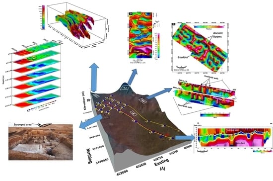
Multi-Scale Geophysical Methodologies Applied to Image Archaeological Ruins at Various Depths in Highly Terraneous Sites
Abstract
1. Introduction
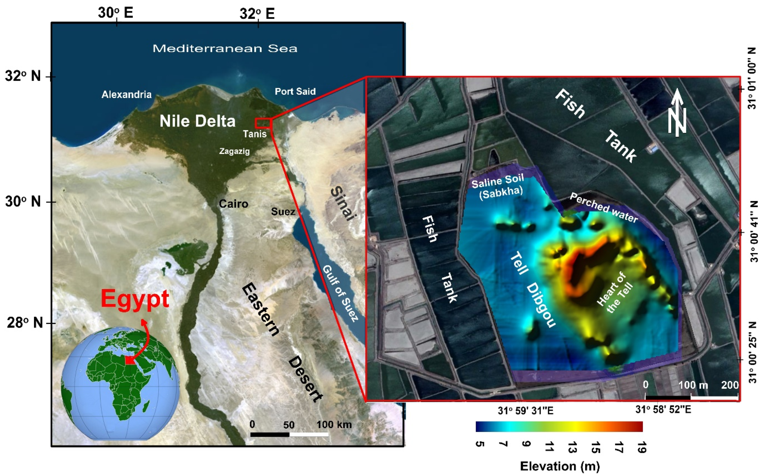
2. Site Description
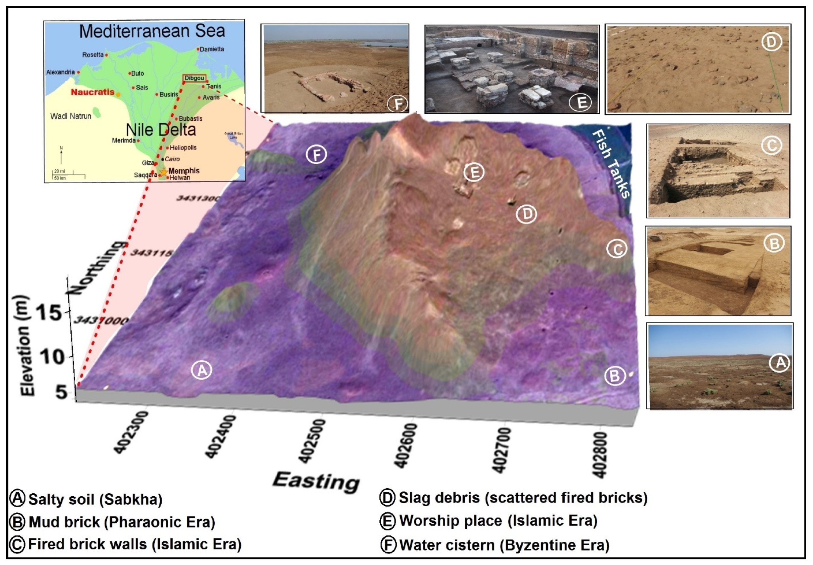
3. Geological and Archaeological Context
4. Methodology
4.1. Survey Procedure and Field Setup
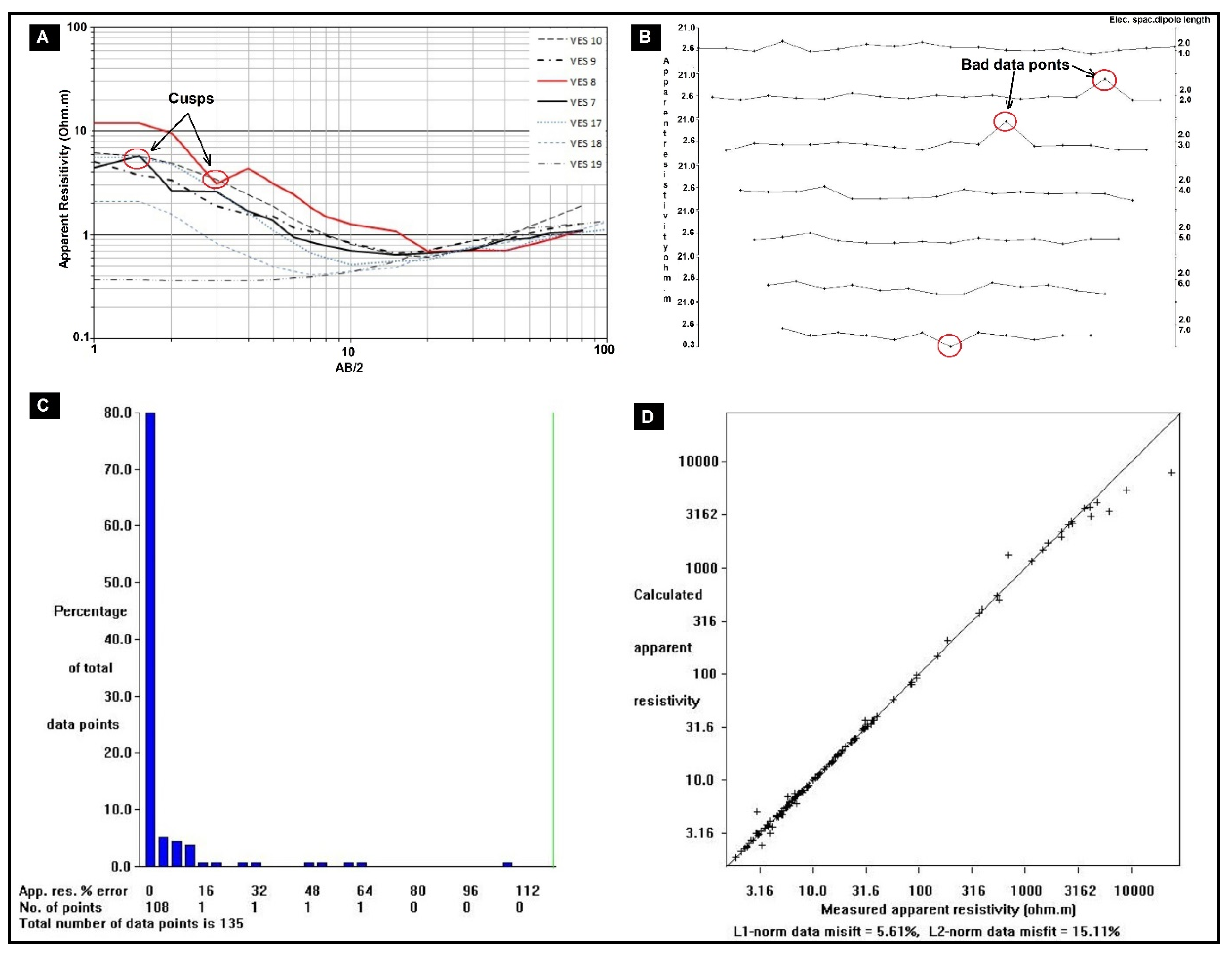
4.2. Data Processing and Inversion
5. Results and Discussion
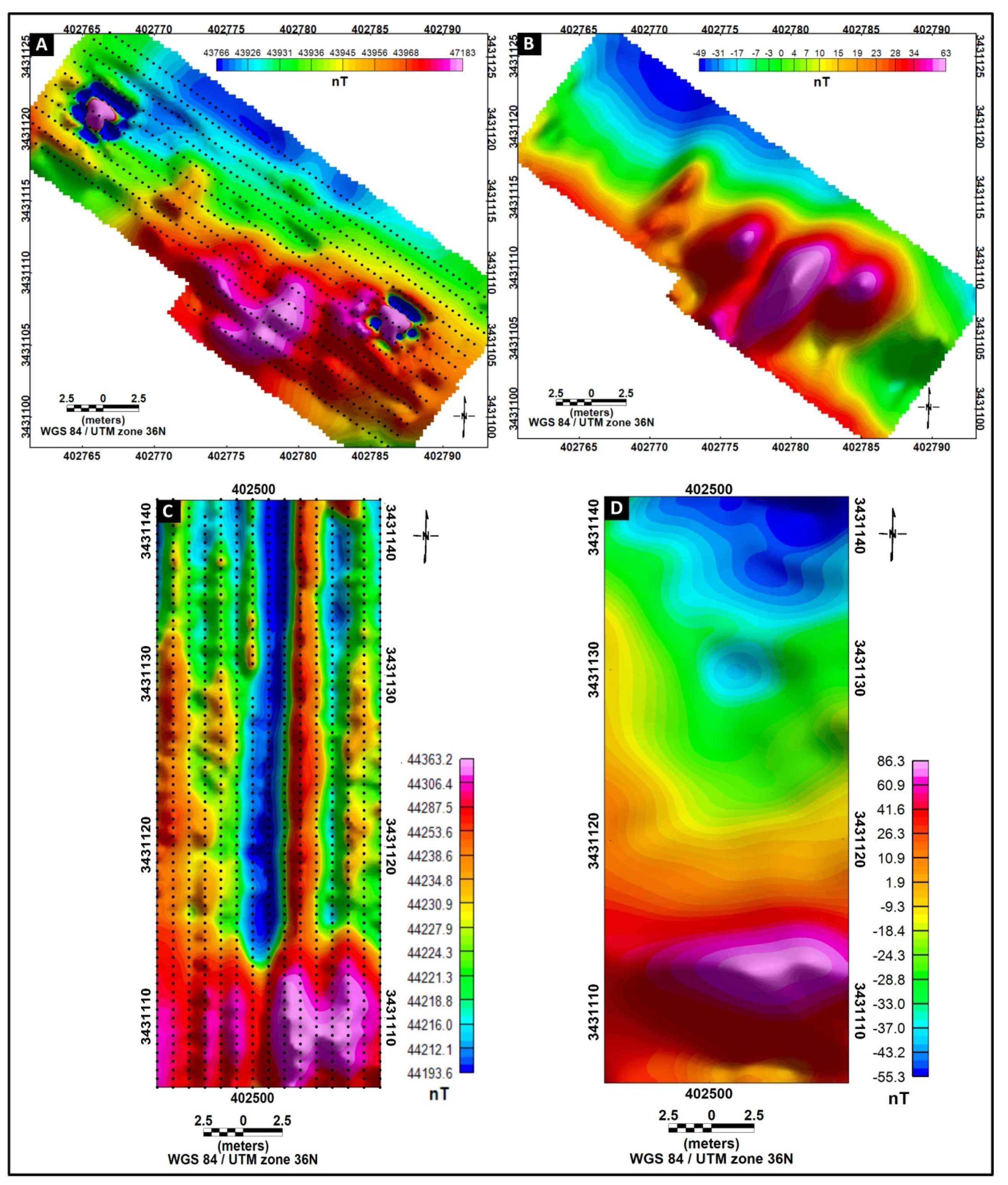
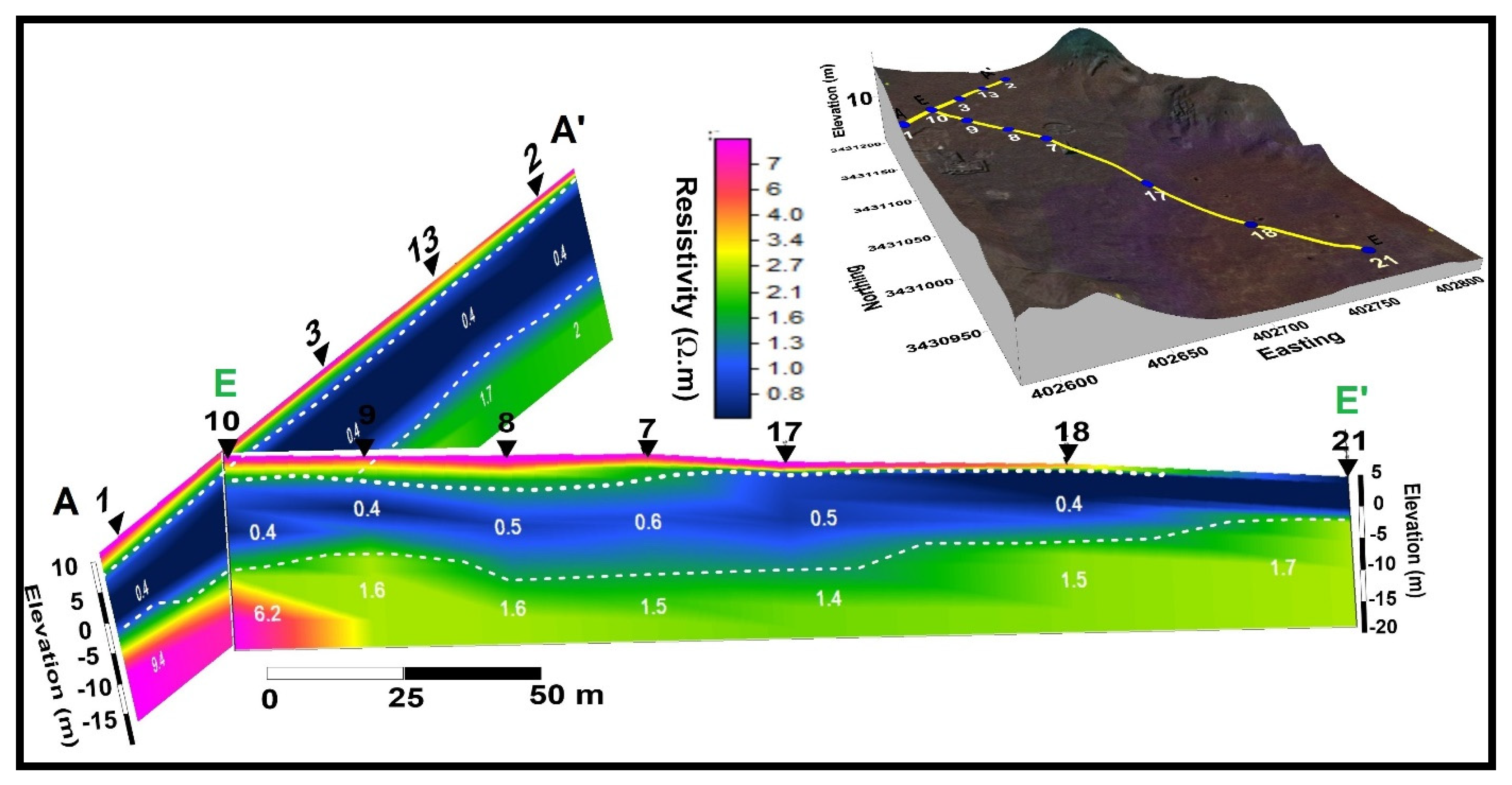
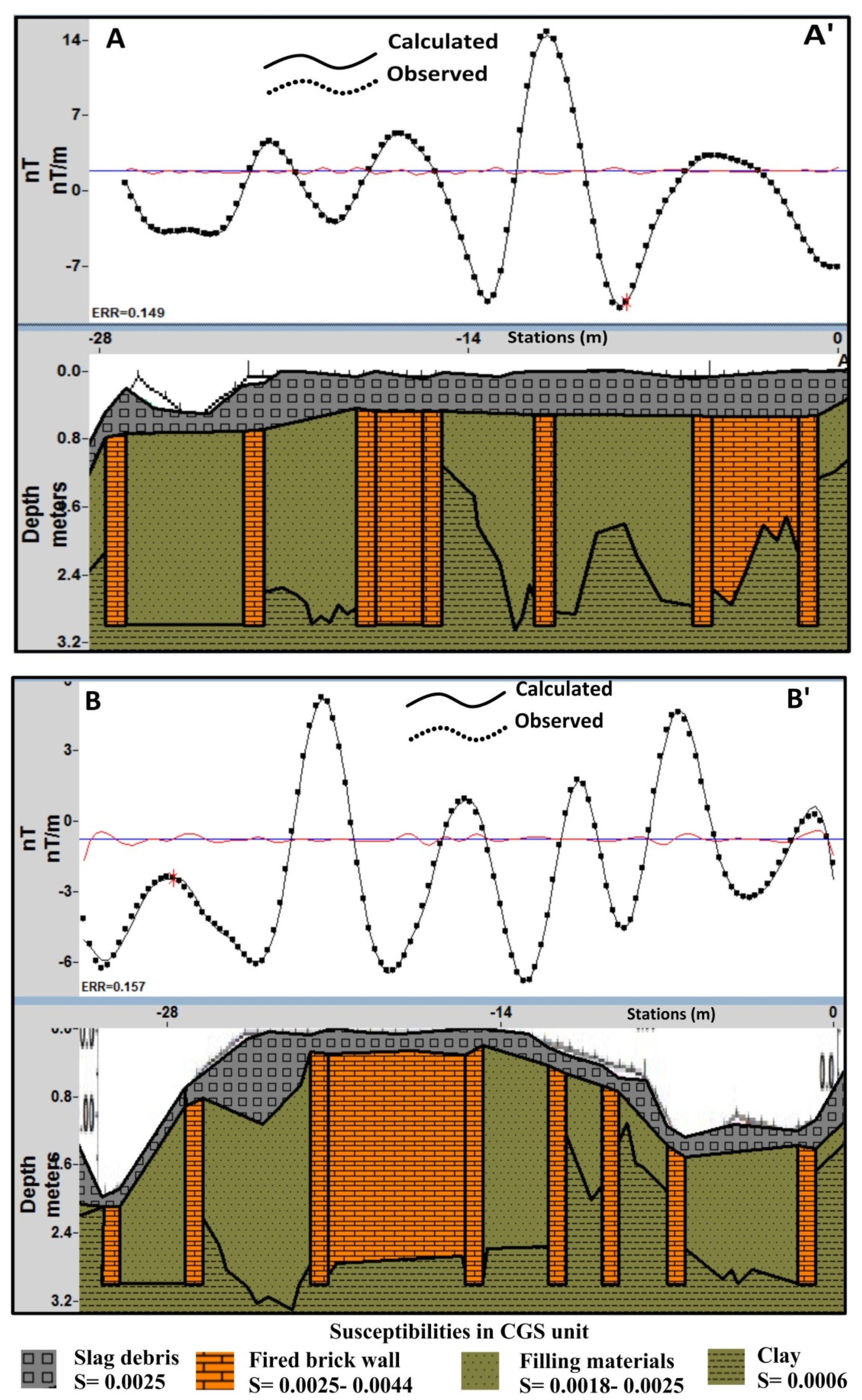
5.1. Area Around Spot A
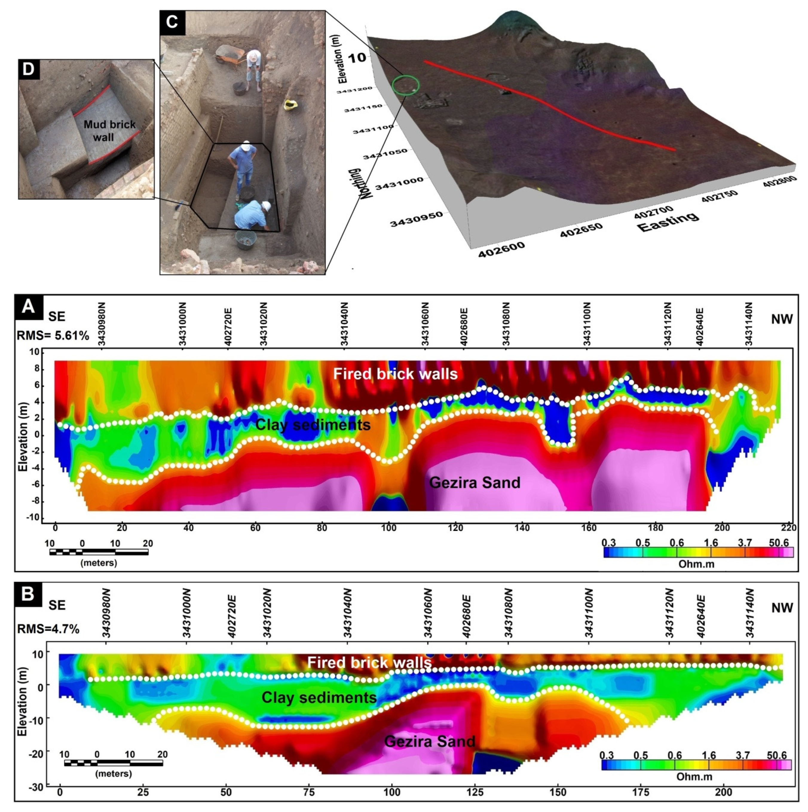
5.2. Area Around Spot B
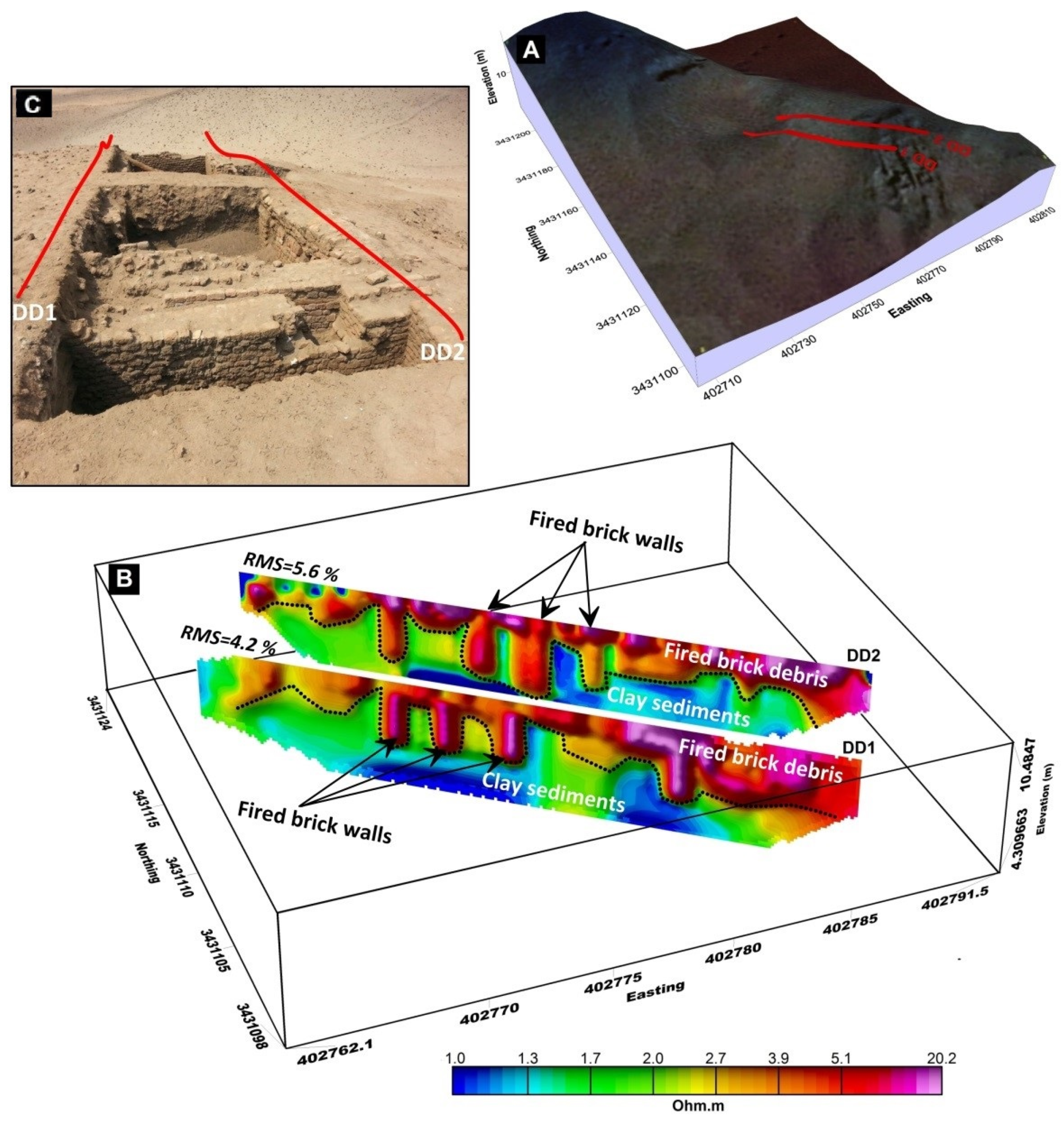
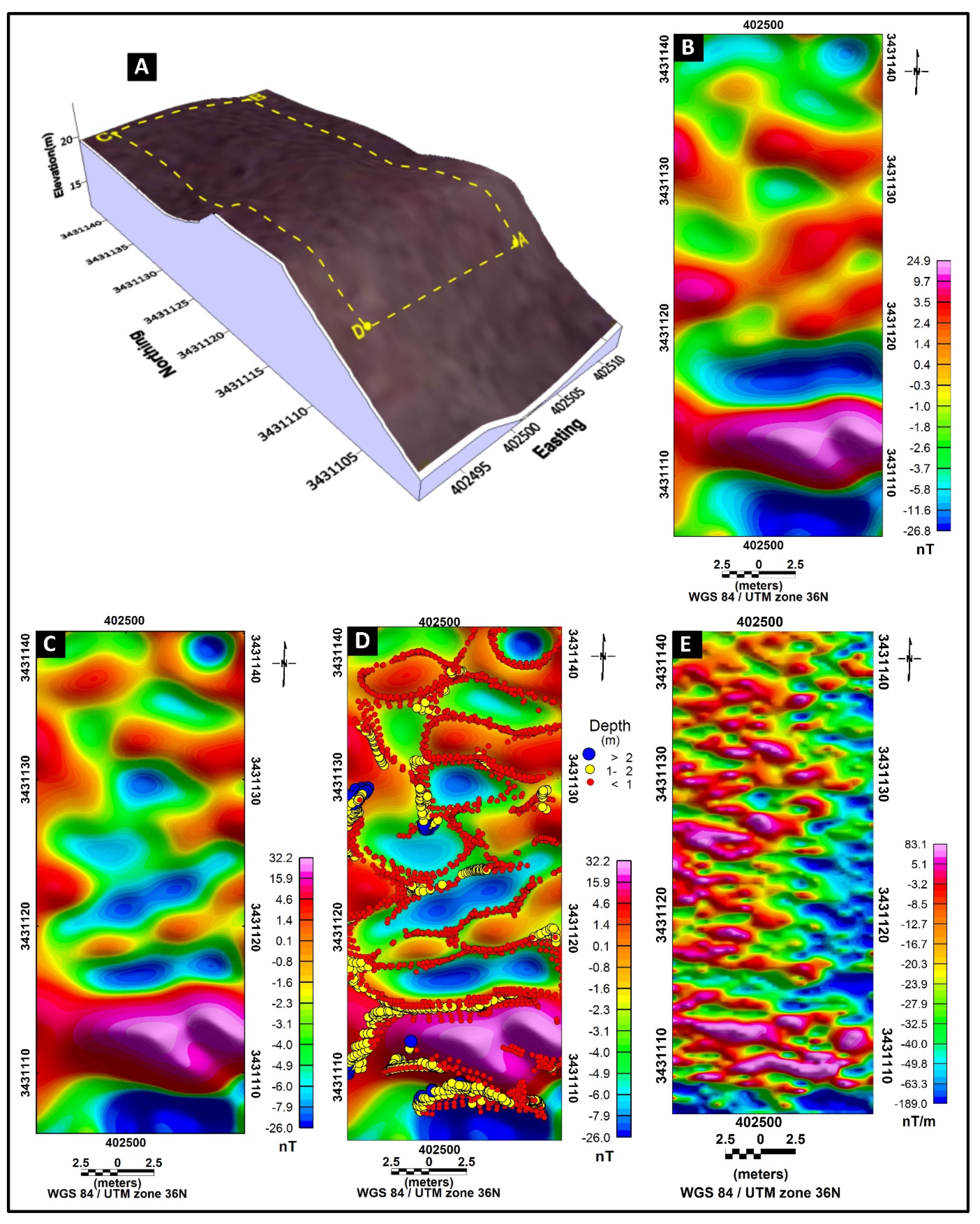
5.3. Area Around Spot C
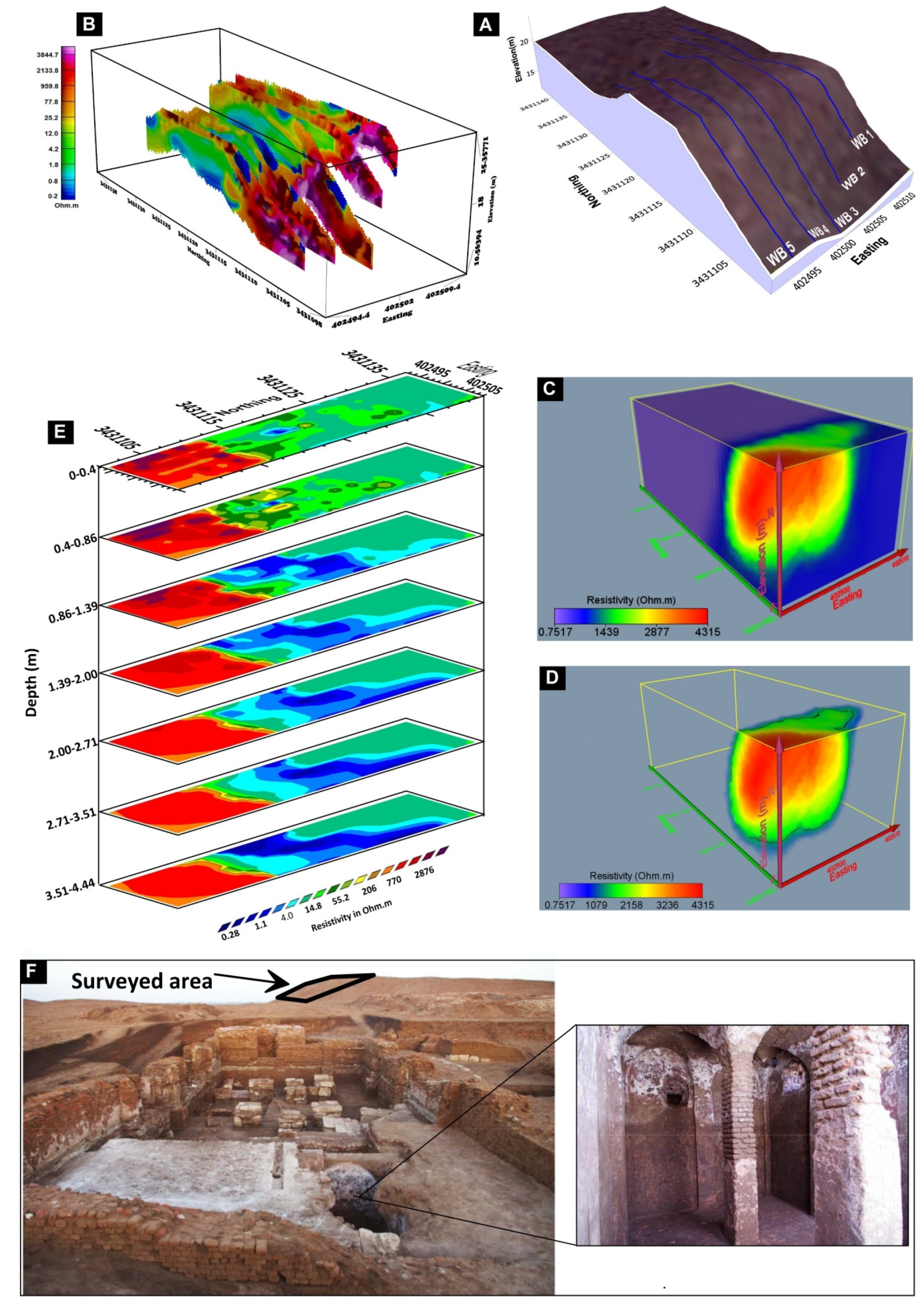
5.4. Area Around Spot D
6. Conclusions
Author Contributions
Funding
Institutional Review Board Statement
Informed Consent Statement
Data Availability Statement
Acknowledgments
Conflicts of Interest
Appreciation
References
- Campana, S.; Piro, S. Seeing the Unseen. Geophysics and Landscape Archaeology; Taylor & Francis: London, UK, 2009; p. 376. [Google Scholar]
- Belvedere, O. Archaeological Survey in Italy between Ancient Topography and Landscape Archaeology. In Göttinger Studien zur Mediterranen Archäologie Bd. 8; Verlag Marie Leidorf GmbH: Rahden, Germany, 2017; ISBN 978-3-86757-507-2. [Google Scholar]
- Trinks, I.; Neubauer, W.; Doneus, M. Prospecting Archaeological Landscapes; Springer: Berlin/Heidelberg, Germany, 2012; pp. 21–29. [Google Scholar]
- Trinks, I.; Neubauer, W.; Hinterleitner, A. First high-resolution GPR and magnetic archaeological prospection at the Viking age settlement of birka in Sweden. Archaeol. Prospect. 2014, 21, 185–199. [Google Scholar] [CrossRef]
- Gustavsen, L.; Stamnes, A.A.; Fretheim, S.E.; Gjerpe, L.E.; Nau, E. The Effectiveness of Large-Scale, High-Resolution Ground-Penetrating Radar Surveys and Trial Trenching for Archaeological Site Evaluations—A Comparative Study from Two Sites in Norway. Remote. Sens. 2020, 12, 1408. [Google Scholar] [CrossRef]
- Cardarelli, E.; Di Filippo, G. Integrated geophysical methods for the characterisation of an archaeological site (Massenzio Basilica—Roman forum, Rome, Italy). J. Appl. Geophys. 2009, 68, 508–521. [Google Scholar] [CrossRef]
- Hegyi, A.; Diaconescu, D.; Urdea, P.; Sarris, A.; Pisz, M.; Onaca, A. Using Geophysics to Characterize a Prehistoric Burial Mound in Romania. Remote. Sens. 2021, 13, 842. [Google Scholar] [CrossRef]
- Drahor, M.G.; Berge, M.A.; Öztürk, C. Integrated geophysical surveys for the subsurface mapping of buried structures under and surrounding of the Agios Voukolos Church in İzmir, Turkey. J. Archaeol. Sci. 2011, 38, 2231–2242. [Google Scholar] [CrossRef]
- Küçükdemirci, M.; Piro, S.; Ozer, E.; Baydemir, N.; Zamuner, D. An integrated Geophysical Survey at Aizanoi Archaeological site (Turkey). In Proceedings of the 11th International Conference on Archaeological Prospection ICAP2015, Warsaw, Poland, 15–19 September 2015; Archaeologia Polona. pp. 477–479, ISSN: 0066-5924. [Google Scholar]
- Küçükdemirci, M.; Özer, E.; Piro, S.; Baydemir, N.; Zamuner, D. An application of integration approaches for archaeo-geophysical data: Case study from Aizanoi. Archaeol. Prospect. 2018, 25, 33–44. [Google Scholar] [CrossRef]
- Abu Zeid, N.; Corradini., E.; Bignardi, S.; Morandi, N.; Nizzo, V. The passive seismic technique “HVSR” as a reconnaissance tool for mapping paleo-soils: The case of the Pilastri archaeological site, Northern Italy. Archaeol. Prospect. 2017, 24, 245–258. [Google Scholar] [CrossRef]
- Deiana, R.; Bonetto, J.; Mazzariol, A. Integrated Electrical Resistivity Tomography and Ground Penetrating Radar Measurements Applied to Tomb Detection. Surv. Geophys. 2018, 39, 1081–1105. [Google Scholar] [CrossRef]
- Arka, I.; Balkaya, Ç.; Pülz, A.; Alanyali, H.S.; Kaya, M.A. Integrated geophysical investigations to reconstruct the archaeological features in the episcopal district of side (Antalya, southern Turkey). J. Appl. Geophys. 2019, 163, 22–30. [Google Scholar] [CrossRef]
- Abu Zeid, N.M.; Bignardi, S.; Russo, P.; Peresani, M. Deep in a Paleolithic archive: Integrated geophysical investigations and laser-scanner reconstruction at Fumane Cave, Italy. J. Archaeol. Sci. Rep. 2019, 27, 1–10. [Google Scholar] [CrossRef]
- Gaber, A.; Gemail, K.S.; Kamel, A.; Atia, H.M.; Ibrahim, A. Integration of 2D/3D ground penetrating radar and electrical resistivity tomography surveys as enhanced imaging of archaeological ruins: A case study in San El-Hager (Tanis) site, northeastern Nile Delta, Egypt. Archaeol. Prospect. 2021. [Google Scholar] [CrossRef]
- Schmidt, A. Electrical and magnetic methods in archaeological prospection. In Seeing the Unseen. Geophysics and Landscape Archaeology; Campana, S., Piro, S., Eds.; Taylor and Francis Group: London, UK, 2009; pp. 67–81. [Google Scholar]
- Salvatore, P.; Enrico, P.; Daniela, Z.; Melda, K. Multimethodological approach to investigate urban and suburban archaeological sites. In Innovation in Near-Surface Geophysics; Elsevier BV: Amsterdam, The Netherlands, 2019; pp. 461–504. [Google Scholar] [CrossRef]
- Tsokas, G.N.; Hansen, R.O. On the use of complex attributes and the inferred source parameter estimates in the exploration of archaeological sites. Archaeol. Prospect. 2000, 7, 17–30. [Google Scholar] [CrossRef]
- Dabas, M.; Anest, A.; Thiesson, J.; Tabbagh, A. Slingram EMI Devices for Characterizing Resistive Features Using Apparent Conductivity Measurements: Check of the DualEM-421S Instrument and Field Tests. Archaeol. Prospect. 2016, 23, 165–180. [Google Scholar] [CrossRef]
- Gaffney, C.; Gater, J.A.; Ovenden, S.M. The Use of Geophysical Techniques in Archaeological Evaluations; IFA Technical Paper 6; Reading Institute of Field Archaeologists, University of Reading: Reading, UK, 2002; ISBN 0 948393 16 3. [Google Scholar]
- Chianese, D.V.; Lapenna, S.; Di Salvia, S.; Perrone, A.; Rizzo, E. Joint geophysical measurements to investigate the Rossano of Vaglio archaeological site (Basilicata region, southern Italy). J. Archaeol. Sci. 2010, 37, 2237–2244. [Google Scholar] [CrossRef]
- Danielsen, B.E.; Dahlin, T. Comparison of geoelectrical imaging and tunnel documentation. Eng. Geol. 2009, 107, 118–129. [Google Scholar] [CrossRef][Green Version]
- Rønning, J.S.; Ganerød, G.V.; Dalsegg, E.; Reiser, F. Resistivity mapping as a tool for identification and characterisation of weakness zones in crystalline bedrock: Definition and testing of an interpretational model. Bull. Eng. Geol. Environ. 2014, 73, 1225–1244. [Google Scholar] [CrossRef]
- Eppelbaum, L.V. Study of magnetic anomalies over archaeological targets in urban conditions. Phys. Chem. Earth 2011, 36, 1318–1330. [Google Scholar] [CrossRef]
- Lapenna, V. Resilient and sustainable cities of tomorrow: The role of applied geophysics. Boll. Geofis. Teor. Appl. 2017, 58, 237–251. [Google Scholar] [CrossRef]
- Smriglio, F.; Papale, E.; Verga, F.; Piro, S. Noninvasive geophysical integrated survey at Madonna del Giglio (Sabine necropolis, Magliano Sabina, Latium, Central Italy). Archaeol. Anthr. Sci. 2020, 12, 1–12. [Google Scholar] [CrossRef]
- Krauss, L.; Klasen, N.; Schulte, P.; Lehmkuhl, F. New results concerning the pedo- and chronostratigraphy of the loess–palaeosol sequence Attenfeld (Bavaria, Germany) derived from a multi-methodological approach. J. Quat. Sci. 2021. [Google Scholar] [CrossRef]
- Welc, F.; Mieszkowski, R.; Vrkljan, G.L.; Konestra, A. An Attempt to Integration of Different Geophysical Methods (Magnetic, GPR and ERT); A Case Study From the Late Roman Settlement On the Island of Rab in Croatia. Stud. Quat. 2017, 34, 47–59. [Google Scholar] [CrossRef]
- Florio, G.; Cella, F.; Speranza, L.; Castaldo, R.; Benoit, R.P.; Palermo, R. Multiscale techniques for 3D imaging of magnetic data for archaeo-geophysical investigations in the Middle East: The case of Tell Barri (Syria). Archaeol. Prospect. 2019, 26, 379–395. [Google Scholar] [CrossRef]
- Li, M.; Zhang, Z.; Yang, J.; Xie, S. Integrated geophysical study in the cemetery of Marquis of Haihun. Archaeol. Prospect. 2021, 1, 13. [Google Scholar] [CrossRef]
- Clark, A. Seeing Beneath the Soil: Prospecting Methods in Archaeology, 2nd ed.; B.T. Batsford: London, UK, 1996. [Google Scholar]
- Cammarano, F.; Di Fiore, B.; Patella, D.; Mauriello, P. Examples of application of electrical tomographies and radar profiling to cultural heritage. Ann. Geophys. 2000, 43, 309–324. [Google Scholar]
- Campana, S.; Dabas, M.; Marasco, L.; Piro, S.; Zamuner, D. Integration of remote sensing, geophysical surveys and archaeological excavation for the study of a medieval mound (Tuscany-Italy). Archaeol. Prospect. 2009, 16, 167–176. [Google Scholar] [CrossRef]
- El-Qady, G.; Metwaly, M.; Drahor, M.G. Geophysical Techniques Applied in Archaeology. In Natural Science in Archaeology; Springer Science and Business Media LLC: Berlin/Heidelberg, Germany, 2018; pp. 1–25. [Google Scholar] [CrossRef]
- Pro, C.; Caldeira, B.; De Tena, M.T.; Charro, C.; Oliveira, R.J.; Borges, J.F.; Mayoral, V. Exploring the Consistency of Data Collected in Archaeological Geophysics: A Case Study from the Iron Age Hillfort of Villasviejas del Tamuja (Extremadura, Spain). Remote Sens. 2020, 12, 1989. [Google Scholar] [CrossRef]
- Edemsky, D.; Popov, A.; Prokopovich, I. Geophysical survey of Tunnug mound periphery, Tuva, Russia. J. Appl. Geophys. 2021, 189, 104326. [Google Scholar] [CrossRef]
- Gaffney, C.F.; Gater, J.A.; Linford, P.; Gaffney, V.L.; White, R. Large-scale systematic fluxgate gradiometry at the roman city of Wroxeter. Archaeol. Prospect. 2000, 7, 81–99. [Google Scholar] [CrossRef]
- Zhai, G.; Bian, G.; Huang, M. A new method to calculate the vertical derivatives of total field magnetic anomaly. Acta Geod. Cartogr. Sin. 2011, 40, 671–678. [Google Scholar]
- Li, Y.; Oldenburg, D.W. Fast inversion of large-scale magnetic data using wavelet transforms and a logarithmic barrier method. Geophys. J. Int. 2003, 152, 251–265. [Google Scholar] [CrossRef]
- Von Der Osten-Woldenburg, H.; Chaume, B.; Reinhard, W. New archaeological discoveries through magnetic gradiometry: The early Celtic settlement on Mont Lassois, France. Geophysics 2006, 25, 46–48. [Google Scholar] [CrossRef]
- Loke, M.; Chambers, J.; Rucker, D.; Kuras, O.; Wilkinson, P. Recent developments in the direct-current geoelectrical imaging method. J. Appl. Geophys. 2013, 95, 135–156. [Google Scholar] [CrossRef]
- Gemail, K.S. Application of 2D resistivity profiling for mapping and interpretation of geology in a till aquitard near Luck Lake, Southern Saskatchewan, Canada. Environ. Earth Sci. 2015, 73, 923–935. [Google Scholar] [CrossRef]
- Fischanger, F.; Catanzariti, G.; Comina, C.; Sambuelli, L.; Morelli, G.; Barsuglia, F.; Ellaithy, A.; Porcelli, F. Geophysical anomalies detected by electrical resistivity tomography in the area surrounding Tutankhamun’s tomb. J. Cult. Herit. 2019, 36, 63–71. [Google Scholar] [CrossRef]
- Abu Salem, H.; Gemail, K.S.; Nosair, A.M. A multidisciplinary approach for delineating wastewater flow paths in shallow groundwater aquifers: A case study in the southeastern part of the Nile Delta, Egypt. J. Contam. Hydrol. 2021, 236, 103701. [Google Scholar] [CrossRef] [PubMed]
- Griffiths, D.H.; Barker, R.D. Electrical Imaging in Archaeology. J. Archaeol. Sci. 1994, 21, 153–158. [Google Scholar] [CrossRef]
- Schmidt, A. Archaeology, magnetic methods. In Encyclopedia of Geomagnetism and Paleomagnetism; Encyclopedia of Earth Sciences Series; Gubbins, D., Herrero-Bervera, E., Eds.; Springer: Heidelberg, NY, USA, 2007. [Google Scholar]
- Masini, N.; Capozzoli, L.; Romano, G.; Sieczkowska, D.; Sileo, M.; Bastante, J.; Victoria, F.A.; Ziolkowski, M.; Lasaponara, R. Archaeogeophysical-Based Approach for Inca Archaeology: Overview and one operational application. Surv. Geophys. 2018, 39, 1239–1262. [Google Scholar] [CrossRef]
- Gemail, K.S.; El Alfy, M.; Ghoneim, M.F.; Shishtawy, A.M.; El-Bary, M.A. Comparison of DRASTIC and DC resistivity modeling for assessing aquifer vulnerability in the central Nile Delta, Egypt. Environ. Earth Sci. 2017, 76, 350. [Google Scholar] [CrossRef]
- Brissaud, A.; Desbordes, C. Activity Report—2019 Campaign, MATD, Mission of Archaeology at Tell Dibgou, No 33, 23P. 2019. Available online: http://www.telldibgou.fr/index.php/rapports-d-activite/2019 (accessed on 1 March 2020).
- Said, R. The Geological Evolution of the River Nile; Springer: Berlin/Heidelberg, Germany, 1981; p. 151. [Google Scholar]
- Wit, H.E.; Stralen, L. Preliminary Results of the 1987 Palaeo-Geographical Survey; van der Brink, E.C.M., Ed.; The archaeology of the Nile Delta: Amsterdam, The Netherlands, 1988; pp. 135–139. [Google Scholar]
- Bietak, M. Tell el-Daba II; OCoLC 776782539; Verlag der Oṡterreichischen Akademie der Wissenschaften: Wien, Austria, 1975. [Google Scholar]
- Abu Al Izz, M.S. Landforms of Egypt; The American University Press: Lanham, MD, USA, 1977; p. 283. [Google Scholar]
- Elwan, A.A.; Harga, M.A.; El Kadi, H.A.; El Demerdash, S. Preliminary studies on the soil of North Sinai Peninsula on aerial photo interpretation. Egypt. J. Soil Sci. 1983, 23, 37. [Google Scholar]
- Reid, A.B. Aeromagnetic survey design. Geophysics 1980, 45, 973–976. [Google Scholar] [CrossRef]
- Reynolds, J.M. An introduction to Applied and Environmental Geophysics, 2nd ed.; Wiley-Blackwell: New York, NY, USA, 2011; ISBN 978-0-471-48535-3. [Google Scholar]
- Loke, M.H. Rapid 2-D Resistivity and IP Inversion Using the Least-Squares Method. 2018. Available online: www.geotomosoft.com (accessed on 14 August 2018).
- Gharibi, M.; Bentley, L.R. Resolution of 3-D Electrical Resistivity Images from Inversions of 2-D Orthogonal Lines. J. Environ. Eng. Geophys. 2005, 10, 339–349. [Google Scholar] [CrossRef]
- Berge, M.A.; Drahor, M.G. Electrical Resistivity Tomography Investigations of Multilayered Archaeological Settlements: Part II—A Case from Old Smyrna Höyük, Turkey. Archaeol. Prospect. 2011, 18, 291–302. [Google Scholar] [CrossRef]
- Rödder, T.; Kneisel, C. Permafrost mapping using quasi-3D resistivity imaging, Murtèl, Swiss Alps. Near Surf. Geophys. 2012, 10, 117–127. [Google Scholar] [CrossRef]
- Schwindt, D.; Kneisel, C. Optimisation of quasi-3D electrical resistivity imaging—Application and inversion for investigating heterogeneous mountain permafrost. Cryosphere Discuss. 2011, 5, 3383–3421. [Google Scholar]
- Papadopoulos, N.G.; Tsourlos, P.; Tsokas, G.N.; Sarris, A. Two-dimensional and three-dimensional resistivity imaging in archaeological site investigation. Archaeol. Prospect. 2006, 13, 163–181. [Google Scholar] [CrossRef]
- Dahlin, T.; Zhou, B. A numerical comparison of 2D resistivity imaging with ten electrode arrays. Geophys. Prospect. 2004, 52, 379–398. [Google Scholar] [CrossRef]
- Loke, M.; Dahlin, T. Methods to Reduce Banding Effects in 3-D Resistivity Inversion. In Proceedings of the Near Surface 2010—16th EAGE European Meeting of Environmental and Engineering Geophysics, Zurich, Switzerland, 6–8 September 2010. [Google Scholar] [CrossRef]
- Tejero-Andrade, A.; Cifuentes, G.; Chávez, R.E.; López-González, A.E.; Delgado-Solórzano, C. L- andCORNER-arrays for 3D electric resistivity tomography: An alternative for geophysical surveys in urban zones. Near Surf. Geophys. 2015, 13, 355–368. [Google Scholar] [CrossRef]
- Bobachev, A.; Modin, I.; Shevinin, V. IPI2Win V2.0: User’s Guide; Moscow State University: Moscow, Russia, 2003; Available online: http://geophys.geol.msu.ru/ipi2win.htm (accessed on 10 January 2003).
- Koefoed, O. Geosounding Principles 1: Resistivity Sounding Measurements; Elsevier Science Publishing Company: Amsterdam, The Netherlands, 1979. [Google Scholar]
- Van Overmeeren, R.A. Aquifer boundaries explored by geoelectrical measurements in the coastal plain of Yemen: A case of equivalence. Geophysics 1989, 54, 38–48. [Google Scholar] [CrossRef]
- Loke, M.H.; Barker, R.D. Rapid least-squares inversion of apparent resistivity pseudosections by a quasi-Newton method. Geophys. Prosp. 1996, 44, 131–152. [Google Scholar] [CrossRef]
- Loke, M.H. Tutorial: 2D and 3D Electrical Imaging Surveys. 2020. Available online: http://www.geotomosoft.com/downloads.php (accessed on 7 August 2020).
- Farquharson, C.G. Constructing piecewise-constant models in multidimensional minimum structure inversions. Geophysics 2008, 73, K1–K9. [Google Scholar] [CrossRef]
- Geosoft. Oasis Montaj 8.3. Mapping and Application System; N5SIV6. Users’ Manual; Geosoft Inc.: West Toronto, ON, Canada, 2015; Available online: https://www.geosoft.com/products/oasis-montaj (accessed on 22 October 2018).
- Auken, E.; Foged, N.; Sørensen, K.I. Model Recognition by 1-D Laterally Constrained Inversion of Resistivity Data. In Proceedings of the 9th Meeting, Environmental and Engineering Geophysical Society—European Section, Prague, Czech Republic, 8 September 2002; pp. 241–244. [Google Scholar] [CrossRef]
- Brissaud, A.; Desbordes, C. Bulletin de la Société Française des Fouilles de Tanis. Activity Report—2018 Campaign, MATD, Mission of Archaeology at Tell Dibgou, No 32, 21P. 2018. Available online: http://www.telldibgou.fr/index.php/rapports-d-activite/2018 (accessed on 1 February 2019).
- Dahlin, T.; Loke, M.H. Quasi-3D resistivity imaging-mapping of three dimensional structures using two dimensional DC resistivity techniques. In Proceedings of the 3rd EEGS Meeting; European Association of Geoscientists & Engineers, Houten, The Netherlands, 11–13 August 1997; pp. 143–146. [Google Scholar]
- Salem, A.; Williams, S.; Fairhead, J.; Ravat, D.; Smith, R. Tilt-depth method: A simple depth estimation method using first-order magnetic derivatives. Lead. Edge 2007, 26, 1502–l505. [Google Scholar] [CrossRef]
- Cooper, G.R.J.; Cowan, D.R. Enhancing potential field data using filters based on the local phase. Comput. Geosci. 2006, 32, 1585–1591. [Google Scholar] [CrossRef]
- Cooper, G.R.J.; Cowan, D.R. Edge enhancement of potential-field data using normalized statistics. Geophysics 2008, 73, 1–4. [Google Scholar] [CrossRef]
- Cooper, G.R.J. Balancing images of potential field data. Geophysics 2009, 74, 17–20. [Google Scholar] [CrossRef]




| Geophysical Surveys | Area of Investigation | ||||||
|---|---|---|---|---|---|---|---|
| Area (A) | Area (B) | Area (C) | Area (D) | ||||
| Geoelectric Survey | VES | Number of sounding points | 22 | ------ | ------ | ------ | |
| 2D ERT survey parameters | Electrode array | WB | DD | DD | WB | ------ | |
| Number of profiles | 1 | 1 | 2 | 5 | ------ | ||
| Profile length | 235 m | 235 m | 30 m | 30 m | ------ | ||
| Number of electrodes | 48 | 48 | 31 | 31 | ------ | ||
| Unit electrode separation (a) | 5 m | 5 m | 1 & 2 m | 1 m | ------ | ||
| Depth levels (n) | 7 | 15 | 6 | 9 | ------ | ||
| Number of measured data | 360 | 332 | 492 | 675 | ------ | ||
| Profile heading | NW-SE | NW-SE | NW-SE | S-N | |||
| Magnetic Survey | Type of survey | ------ | Total and gradient | Total and gradient | Total Field | ||
| Covered area | ------ | 384 m2 | 525 m2 | 160 m2 | |||
| Sampling interval | ------ | 0.5 m | 0.5 m | 0.5 m | |||
| Bottom sensor height | ------ | 1.2 m | 0.6 m | 1.2 m | |||
| Top sensor height | ------ | 2.4 m | 1.2 m | ------ | |||
| Traverse heading | ------ | S-N | NW-SE | N-S | |||
Publisher’s Note: MDPI stays neutral with regard to jurisdictional claims in published maps and institutional affiliations. |
© 2021 by the authors. Licensee MDPI, Basel, Switzerland. This article is an open access article distributed under the terms and conditions of the Creative Commons Attribution (CC BY) license (https://creativecommons.org/licenses/by/4.0/).
Share and Cite
Ibrahim, A.; Gemail, K.S.; Abdelrahman, K.; Al-Otaibi, N.; Ibrahim, E.; Saada, S.A. Multi-Scale Geophysical Methodologies Applied to Image Archaeological Ruins at Various Depths in Highly Terraneous Sites. Remote Sens. 2021, 13, 2055. https://doi.org/10.3390/rs13112055
Ibrahim A, Gemail KS, Abdelrahman K, Al-Otaibi N, Ibrahim E, Saada SA. Multi-Scale Geophysical Methodologies Applied to Image Archaeological Ruins at Various Depths in Highly Terraneous Sites. Remote Sensing. 2021; 13(11):2055. https://doi.org/10.3390/rs13112055
Chicago/Turabian StyleIbrahim, Amin, Khaled S. Gemail, Kamal Abdelrahman, Naif Al-Otaibi, Elkhedr Ibrahim, and Saada A. Saada. 2021. "Multi-Scale Geophysical Methodologies Applied to Image Archaeological Ruins at Various Depths in Highly Terraneous Sites" Remote Sensing 13, no. 11: 2055. https://doi.org/10.3390/rs13112055
APA StyleIbrahim, A., Gemail, K. S., Abdelrahman, K., Al-Otaibi, N., Ibrahim, E., & Saada, S. A. (2021). Multi-Scale Geophysical Methodologies Applied to Image Archaeological Ruins at Various Depths in Highly Terraneous Sites. Remote Sensing, 13(11), 2055. https://doi.org/10.3390/rs13112055


