Modeling Gully Erosion Susceptibility to Evaluate Human Impact on a Local Landscape System in Tigray, Ethiopia
Abstract
1. Introduction
2. Study Area
3. Modeling Gully Erosion
4. Material and Methods
4.1. Database
4.2. Gully Erosion Conditioning Factors
4.3. Data Processing
5. Results
5.1. Gully Head Distribution
5.2. Model Performance
5.3. Variable Importance
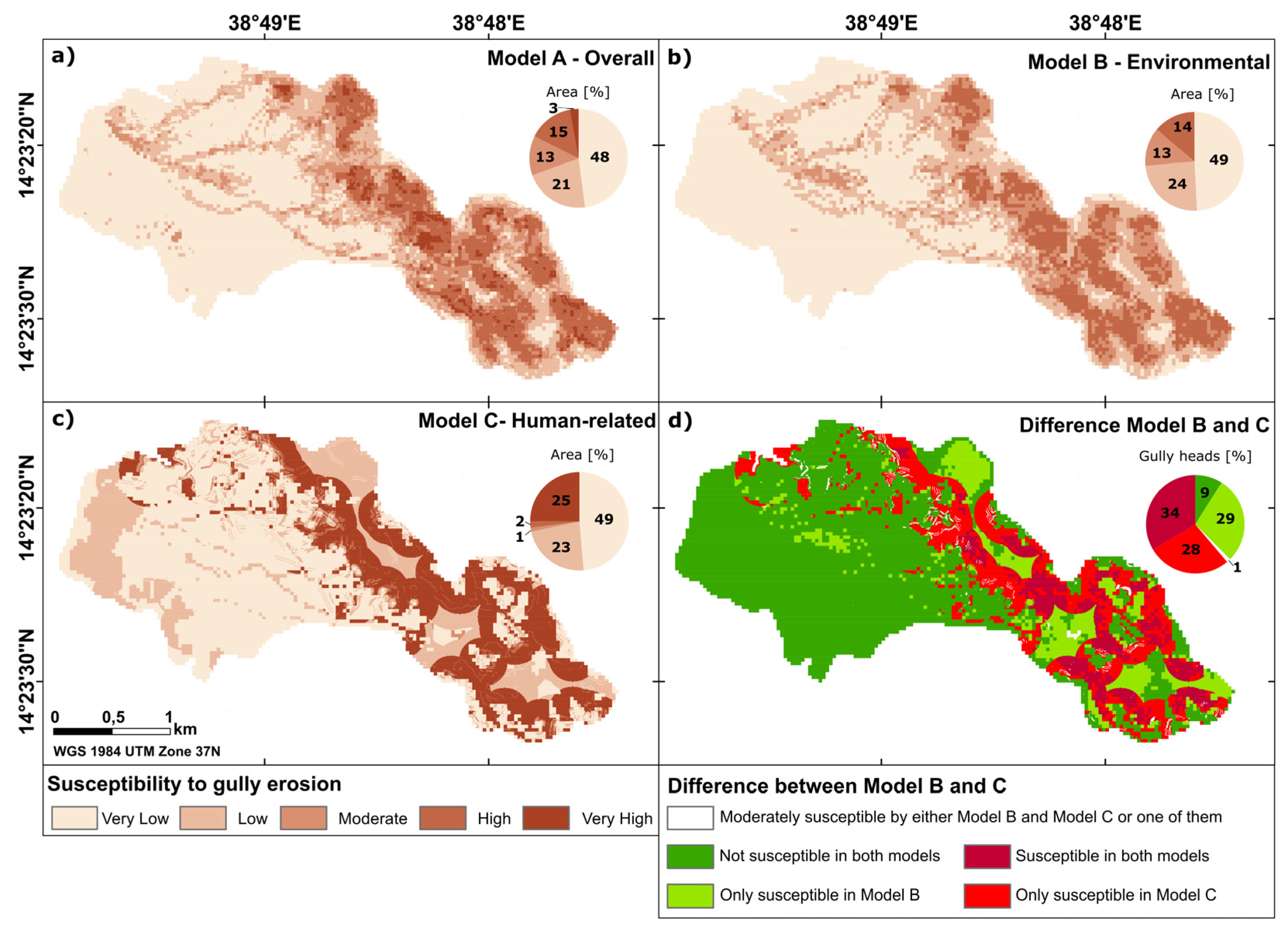
5.4. Spatial Distribution of Gully Erosion Susceptibility
5.5. Change Detection
5.5.1. Areas Predicted as Susceptible to Gully Erosion by Model B and Model C
5.5.2. Areas Predicted as Susceptible to Gully Erosion Only by Model B
5.5.3. Areas Predicted as Susceptible to Gully Erosion Only by Model C
5.5.4. Areas Predicted to Have Moderate Gully Erosion Susceptibility by Either Model B and Model C or by One of Them
5.5.5. Areas Predicted as Non-Susceptible to Gully Erosion by Either Model B and Model C or by One of Them
6. Discussion
6.1. Modeling Gully Erosion Susceptibility
6.2. Human Influence on Gully Erosion
6.2.1. Land Use and Land Cover
6.2.2. Distance from Pathways
6.2.3. Distance from Settlements
6.3. Modeling Environmental and Human-Related Factors
7. Conclusions
Supplementary Materials
Author Contributions
Funding
Data Availability Statement
Acknowledgments
Conflicts of Interest
References
- Castillo, C.; Gómez, J. A century of gully erosion research: Urgency, complexity and study approaches. Earth-Sci. Rev. 2016, 160, 300–319. [Google Scholar] [CrossRef]
- Léonard, J.; Richard, G. Estimation of runoff critical shear stress for soil erosion from soil shear strength. Catena 2004, 57, 233–249. [Google Scholar] [CrossRef]
- Haregeweyn, N.; Tsunekawa, A.; Nyssen, J.; Poesen, J.; Tsubo, M.; Meshesha, D.T.; Schütt, B.; Adgo, E.; Tegegne, F. Soil erosion and conservation in Ethiopia. Prog. Phys. Geogr. Earth Environ. 2015, 39, 750–774. [Google Scholar] [CrossRef]
- Taddese, G. Land degradation: A challenge to Ethiopia. Environ. Manag. 2001, 27, 815–824. [Google Scholar] [CrossRef] [PubMed]
- Valentin, C.; Poesen, J.; Li, Y. Gully erosion: Impacts, factors and control. Catena 2005, 63, 132–153. [Google Scholar] [CrossRef]
- Poesen, J.; Nachtergaele, J.; Verstraeten, G.; Valentin, C. Gully erosion and environmental change: Importance and research needs. Catena 2003, 50, 91–133. [Google Scholar] [CrossRef]
- Arabameri, A.; Pradhan, B.; Pourghasemi, H.R.; Rezaei, K.; Kerle, N. Spatial Modelling of Gully Erosion Using GIS and R Programing: A Comparison among Three Data Mining Algorithms. Appl. Sci. 2018, 8, 1369. [Google Scholar] [CrossRef]
- Arabameri, A.; Blaschke, T.; Pradhan, B.; Pourghasemi, H.R.; Tiefenbacher, J.P.; Bui, D.T. Evaluation of Recent Advanced Soft Computing Techniques for Gully Erosion Susceptibility Mapping: A Comparative Study. Sensors 2020, 20, 335. [Google Scholar] [CrossRef]
- Hosseinalizadeh, M.; Kariminejad, N.; Chen, W.; Pourghasemi, H.R.; Alinejad, M.; Behbahani, A.M.; Tiefenbacher, J.P. Gully headcut susceptibility modeling using functional trees, naïve Bayes tree, and random forest models. Geoderma 2019, 342, 1–11. [Google Scholar] [CrossRef]
- Pourghasemi, H.R.; Yousefi, S.; Kornejady, A.; Cerdà, A. Performance assessment of individual and ensemble data-mining techniques for gully erosion modeling. Sci. Total Environ. 2017, 609, 764–775. [Google Scholar] [CrossRef]
- Bocco, G. Gully erosion: Processes and models. Prog. Phys. Geogr. Earth Environ. 1991, 15, 392–406. [Google Scholar] [CrossRef]
- Dotterweich, M. The history of soil erosion and fluvial deposits in small catchments of central Europe: Deciphering the long-term interaction between humans and the environment—A review. Geomorphology 2008, 101, 192–208. [Google Scholar] [CrossRef]
- Oldeman, L.R. Guidelines for General Assessment of the Status of Human-Inducted Soil Degradation; ISRIC: Wageningen, The Netherlands, 1988. [Google Scholar]
- Schütt, B.; Förch, G.; Thiemann, S. Soil erosion processes and landscape sensitivity in the Ethiopian Highlands. In Sustainable Management of Water Resources: Challenges and Prospects; Prasad, H., Abate, K., Ondieki, C.M., Eds.; Kenyatta University: Nairobi, Kenya, 2005; pp. 177–203. [Google Scholar]
- Schütt, B. Die indirekten Einflüsse des Menschen auf die Reliefsphäre. In Die Erdoberfläche-Lebens-und Gestaltungsraum Des Menschen: Forschungsstrategische und Programmatische Leitlinien Zukünftiger Geomorphologischer Forschung und Lehre; Dikau, R., Moldenhauer, K.-M., Bedehäsing, J., Eds.; Gebrüder Borntraeger: Berlin, Germany, 2006; pp. 47–55. ISBN 9783443211486. [Google Scholar]
- Sidle, R.C.; Jarihani, B.; Kaka, S.I.; Koci, J.; Al-Shaibani, A. Hydrogeomorphic processes affecting dryland gully erosion: Implications for modelling. Prog. Phys. Geogr. Earth Environ. 2019, 43, 46–64. [Google Scholar] [CrossRef]
- Nyssen, J.; Poesen, J.; Moeyersons, J.; Deckers, J.; Haile, M.; Lang, A. Human impact on the environment in the Ethiopian and Eritrean highlands—a state of the art. Earth-Sci. Rev. 2004, 64, 273–320. [Google Scholar] [CrossRef]
- Sidle, R.C.; Ochiai, H. Landslides: Processes, Prediction, and Land Use; American Geophysical Union: Washington, DC, USA, 2006; ISBN 978-0-87590-322-4. [Google Scholar]
- Bull, L.; Kirkby, M. Gully processes and modelling. Prog. Phys. Geogr. Earth Environ. 1997, 21, 354–374. [Google Scholar] [CrossRef]
- Kirkby, M.J.; Bracken, L.J. Gully processes and gully dynamics. Earth Surf. Process. Landf. 2009, 34, 1841–1851. [Google Scholar] [CrossRef]
- Nir, N.; Knitter, D.; Hardt, J.; Schütt, B. Human movement and gully erosion: Investigating feedback mechanisms using Frequency Ratio and Least Cost Path analysis in Tigray, Ethiopia. PLoS ONE 2021, 16, e0245248. [Google Scholar] [CrossRef]
- Frankl, A. Gully development and its spatio-temporal variability since the late 19th century in the northern Ethiopian Highlands. Afr. Focus 2012, 25, 25. [Google Scholar] [CrossRef]
- Nyssen, J.; Vandenreyken, H.; Poesen, J.; Moeyersons, J.; Deckers, J.; Haile, M.; Salles, C.; Govers, G. Rainfall erosivity and variability in the Northern Ethiopian Highlands. J. Hydrol. 2005, 311, 172–187. [Google Scholar] [CrossRef]
- Climate-Data.org. Klima Adwa (Äthiopien). Available online: https://de.climate-data.org/afrika/aethiopien/tigray/adwa-31960/ (accessed on 1 January 2021).
- Abebe, B.A. Modeling the Effect of Climate and Land Use Change on the Water Resources in Northern Ethiopia: The Case of Suluh River Basin. Ph.D. Thesis, Freie Universität Berlin, Berlin, Germany, 2014. [Google Scholar]
- Lemenih, E.M. Production, Value Addition and Marketing of Non-Wood Forest Products (NWFPs) from Arid and Semi-Arid Lands (ASALs) of Ethiopia; Intergovernmental Authority on Development: Addis Ababa, Ethiopia, 2010. [Google Scholar]
- Jones, A.; Breuning-Madsen, H.; Brossard, M.; Dampha, A.; Deckers, J.; Dewitte, O.; Gallali, T.; Hallett, S.; Jones, R.; Kilasara, M.; et al. Soil Atlas of Afrika; Publications Office of the European Union: Luxembourg, 2013. [Google Scholar]
- Conoscenti, C.; Di Maggio, C.; Rotigliano, E. Soil erosion susceptibility assessment and validation using a geostatistical multivariate approach: A test in Southern Sicily. Nat. Hazards 2008, 46, 287–305. [Google Scholar] [CrossRef]
- Ghosh, S.; Guchhait, S.K. Geomorphic Threshold and SCS-CN-Based Runoff and Sediment Yield Modelling in the Gullies of Dwarka–Brahmani Interfluve, West Bengal, India. In Gully Erosion Studies from India and Surrounding Regions; Shit, P.K., Pourghasemi, H.R., Bhunia, G.S., Eds.; Springer International Publishing: Cham, Switzerland, 2020; pp. 45–68. ISBN 978-3-030-23242-9. [Google Scholar]
- Schumm, S.A. Geomorphic Thresholds: The Concept and Its Applications. Trans. Inst. Br. Geogr. 1979, 4, 485. [Google Scholar] [CrossRef]
- Arabameri, A.; Pradhan, B.; Rezaei, K.; Conoscenti, C. Gully erosion susceptibility mapping using GIS-based multi-criteria decision analysis techniques. Catena 2019, 180, 282–297. [Google Scholar] [CrossRef]
- Rahmati, O.; Haghizadeh, A.; Pourghasemi, H.R.; Noormohamadi, F. Gully erosion susceptibility mapping: The role of GIS-based bivariate statistical models and their comparison. Nat. Hazards 2016, 82, 1231–1258. [Google Scholar] [CrossRef]
- Razavi-Termeh, S.V.; Sadeghi-Niaraki, A.; Choi, S.-M. Gully erosion susceptibility mapping using artificial intelligence and statistical models. Geomat. Nat. Hazards Risk 2020, 11, 821–844. [Google Scholar] [CrossRef]
- Zabihi, M.; Mirchooli, F.; Motevalli, A.; Darvishan, A.K.; Pourghasemi, H.R.; Zakeri, M.A.; Sadighi, F. Spatial modelling of gully erosion in Mazandaran Province, northern Iran. Catena 2018, 161, 1–13. [Google Scholar] [CrossRef]
- Boardman, J. Soil erosion science: Reflections on the limitations of current approaches. Catena 2006, 68, 73–86. [Google Scholar] [CrossRef]
- Jungerius, P.D.; Matundura, J.; Van De Ancker, J.A.M. Road construction and gully erosion in West Pokot, Kenya. Earth Surf. Process. Landf. 2002, 27, 1237–1247. [Google Scholar] [CrossRef]
- Nyssen, J.; Poesen, J.; Moeyersons, J.; Luyten, E.; Veyret-Picot, M.; Deckers, J.A.; Haile, M.; Govers, G. Impact of road building on gully erosion risk: A case study from the Northern Ethiopian Highlands. Earth Surf. Process. Landf. 2002, 27, 1267–1283. [Google Scholar] [CrossRef]
- Wischmeier, W.H.; Smith, D.D. Predicting Rainfall Erosion Losses: A Guide to Conservation Planning; Department of Agriculture, Science and Education Administration: Washington, DC, USA, 1978. [Google Scholar]
- Alewell, C.; Borrelli, P.; Meusburger, K.; Panagos, P. Using the USLE: Chances, challenges and limitations of soil erosion modelling. Int. Soil Water Conserv. Res. 2019, 7, 203–225. [Google Scholar] [CrossRef]
- Evans, R.; Boardman, J. The new assessment of soil loss by water erosion in Europe. Panagos P. et al., 2015 Environmental Science & Policy 54, 438–447—A response. Environ. Sci. Policy 2016, 58, 11–15. [Google Scholar] [CrossRef]
- Knisel, W.G. CREAMS: A Field Scale Model for Chemicals, Runoff, and Erosion from Agricultural Management Systems; Conservation report; Department of Agriculture, Science and Education Administration: Washington, DC, USA, 1980; Volume 26, p. 640. [Google Scholar]
- Morgan, R.P.C.; Quinton, J.N.; Smith, R.E.; Govers, G.; Poesen, J.; Auerswald, K.; Chisci, G.; Torri, D.; Styczen, M.E. The European Soil Erosion Model (EUROSEM): A dynamic approach for predicting sediment transport from fields and small catchments. Earth Surf. Process. Landf. 1998, 23, 527–544. [Google Scholar] [CrossRef]
- Woodward, D. Method to predict cropland ephemeral gully erosion. Catena 1999, 37, 393–399. [Google Scholar] [CrossRef]
- Flanagan, D.C.; Ascough, J.C.; Nearing, M.A.; Laflen, J.M. The Water Erosion Prediction Project (WEPP) Model. In Landscape Erosion and Evolution Modeling; Springer Science and Business Media LLC: Berlin, Germany, 2001; pp. 145–199. [Google Scholar]
- Gayen, A.; Pourghasemi, H.R.; Saha, S.; Keesstra, S.; Bai, S. Gully erosion susceptibility assessment and management of hazard-prone areas in India using different machine learning algorithms. Sci. Total Environ. 2019, 668, 124–138. [Google Scholar] [CrossRef] [PubMed]
- Breiman, L. Manual on Setting up, Using, and Understanding Random Forests v3.1; Statistics Department University of California Berke: California, CA, USA, 2002. [Google Scholar]
- Rahmati, O.; Tahmasebipour, N.; Haghizadeh, A.; Pourghasemi, H.R.; Feizizadeh, B. Evaluating the influence of geo-environmental factors on gully erosion in a semi-arid region of Iran: An integrated framework. Sci. Total Environ. 2017, 579, 913–927. [Google Scholar] [CrossRef] [PubMed]
- Harden, C.P. Incorporating roads and footpath in watershed-scale hydrologic and soil erosion models. Phys. Geogr. 1992, 13, 368–385. [Google Scholar] [CrossRef]
- Tarboton, D.G.; Bras, R.L.; Rodriguez-Iturbe, I. A physical basis for drainage density. Geomorphology 1992, 5, 59–76. [Google Scholar] [CrossRef]
- Böhner, J.; Selige, T. Spatial prediction of soil attributes using terrain analysis and climate regionalization. Göttinger Geograph. Abh. 2002, 115, 13–27. [Google Scholar]
- Panagos, P.; Borrelli, P.; Poesen, J.; Ballabio, C.; Lugato, E.; Meusburger, K.; Montanarella, L.; Alewell, C. The new assessment of soil loss by water erosion in Europe. Environ. Sci. Policy 2015, 54, 438–447. [Google Scholar] [CrossRef]
- Jasiewicz, J.; Stepinski, T.F. Geomorphons—A pattern recognition approach to classification and mapping of landforms. Geomorphology 2013, 182, 147–156. [Google Scholar] [CrossRef]
- Kiss, R. Determination of drainage network in digital elevation models, utilities and limitations. J. Hung. Geomath. 2004, 2, 16–29. [Google Scholar]
- Bisrat, E.; Kidanewold, B. Identification of surface water storing sites using Topographic Wetness Index (TWI) and Normalized Difference Vegetation Index (NDVI). J. Nat. Resour. Dev. 2018, 8, 91–100. [Google Scholar]
- Tadesse, T.; Habteselassie, B.; Mekonnen, T.; Tadesse, A.; Mahari, K.; Gudaya, A.; Seyid, G.; Genzebu, W.; Birhane, S.; Haro, W.; et al. Geological Map of Axum, Mapsheet: ND 37-6; Geological Survey of Ethiopia: Addis Ababa, Ethiopia, 1999.
- Dube, F.; Nhapi, I.; Murwira, A.; Gumindoga, W.; Goldin, J.; Mashauri, D. Potential of weight of evidence modelling for gully erosion hazard assessment in Mbire District–Zimbabwe. Phys. Chem. Earth Parts A/B/C 2014, 67–69, 145–152. [Google Scholar] [CrossRef]
- Moore, I.D.; Grayson, R.B.; Ladson, A.R. Digital terrain modelling: A review of hydrological, geomorphological, and biological applications. Hydrol. Process. 1991, 5, 3–30. [Google Scholar] [CrossRef]
- Beven, K.J.; Kirkby, M.J. A physically based, variable contributing area model of basin hydrology/Un modèle à base physique de zone d’appel variable de l’hydrologie du bassin versant. Hydrol. Sci. Bull. 1979, 24, 43–69. [Google Scholar] [CrossRef]
- Breiman, L. Random Forests. Mach. Learn. 2001, 45, 5–32. [Google Scholar] [CrossRef]
- Liaw, A.; Wiener, M. Classification and Regression by RandomForest. R News 2001, 2, 18–22. [Google Scholar]
- Breiman, L. Bagging Predictors. Mach. Learn. 1996, 24, 123–140. [Google Scholar] [CrossRef]
- Micheletti, N.; Foresti, L.; Robert, S.; Leuenberger, M.; Pedrazzini, A.; Jaboyedoff, M.; Kanevski, M. Machine Learning Feature Selection Methods for Landslide Susceptibility Mapping. Math. Geosci. 2014, 46, 33–57. [Google Scholar] [CrossRef]
- Nicodemus, K.K. Letter to the Editor: On the stability and ranking of predictors from random forest variable importance measures. Brief. Bioinform. 2011, 12, 369–373. [Google Scholar] [CrossRef]
- Gayen, A.; Haque, S.M.; Saha, S. Modeling of Gully Erosion Based on Random Forest Using GIS and R. In Gully Erosion Studies from India and Surrounding Regions; Shit, P.K., Pourghasemi, H.R., Bhunia, G.S., Eds.; Springer International Publishing: Cham, Switzerland, 2020; pp. 35–44. ISBN 978-3-030-23242-9. [Google Scholar]
- Braun, A.C. More accurate less meaningful? A critical physical geographer’s reflection on interpreting remote sensing land-use analyses. Prog. Phys. Geogr. Earth Environ. 2021. [Google Scholar] [CrossRef]
- Calle, M.L.; Urrea, V. Letter to the Editor: Stability of Random Forest importance measures. Brief. Bioinform. 2010, 12, 86–89. [Google Scholar] [CrossRef] [PubMed]
- Ahnert, F. Equilibrium, scale and inheritance in geomorphology. Geomorphology 1994, 11, 125–140. [Google Scholar] [CrossRef]
- Bork, H.-R. Landschaftsentwicklung in Mitteleuropa: Wirkungen des Menschen auf Landschaften; Klett-Perthes: Gotha, Germany, 1998; ISBN 3-623-00849-4. [Google Scholar]
- Dotterweich, M. The history of human-induced soil erosion: Geomorphic legacies, early descriptions and research, and the development of soil conservation—A global synopsis. Geomorphology 2013, 201, 1–34. [Google Scholar] [CrossRef]
- Berking, J.; Beckers, B.; Schütt, B. Runoff in two semi-arid watersheds in a geoarcheological context: A case study of Naga, Sudan, and Resafa, Syria. Geoarchaeology 2010, 25, 815–836. [Google Scholar] [CrossRef]
- Berking, J.; Beckers, B.; Knitter, D.; Schütt, B. Problems Concerning Ancient Water Management in the Mediterranean. J. Anc. Stud. 2016, 6, 74–101. [Google Scholar]
- Torri, D.; Rossi, M.; Brogi, F.; Marignani, M.; Bacaro, G.; Santi, E.; Tordoni, E.; Amici, V.; Maccherini, S. Badlands and the Dynamics of Human History, Land Use, and Vegetation Through Centuries. In Badlands Dynamics in a Context of Global Change; Elsevier Science: Amsterdam, The Netherlands, 2018; pp. 111–153. [Google Scholar]
- Young, R.A.; Wiersma, J.L. The role of rainfall impact in soil detachment and transport. Water Resour. Res. 1973, 9, 1629–1636. [Google Scholar] [CrossRef]
- Zhang, Q.; Wang, Z.; Wu, B.; Shen, N.; Liu, J. Identifying sediment transport capacity of raindrop-impacted overland flow within transport-limited system of interrill erosion processes on steep loess hillslopes of China. Soil Tillage Res. 2018, 184, 109–117. [Google Scholar] [CrossRef]
- Zheng, F.-L. Effect of Vegetation Changes on Soil Erosion on the Loess Plateau. Pedosphere 2006, 16, 420–427. [Google Scholar] [CrossRef]
- Zhou, P.; Luukkanen, O.; Tokola, T.; Nieminen, J. Effect of vegetation cover on soil erosion in a mountainous watershed. Catena 2008, 75, 319–325. [Google Scholar] [CrossRef]
- Bryan, R.; Jones, J. The significance of soil piping processes: Inventory and prospect. Geomorphology 1997, 20, 209–218. [Google Scholar] [CrossRef]
- Derbyshire, E. Geological hazards in loess terrain, with particular reference to the loess regions of China. Earth-Sci. Rev. 2001, 54, 231–260. [Google Scholar] [CrossRef]
- Schütt, B.; Frechen, M.; Hoelzmann, P.; Fritzenwenger, G. Late Quaternary landscape evolution in a small catchment on the Chinese Loess Plateau. Quat. Int. 2011, 234, 159–166. [Google Scholar] [CrossRef]
- Wilson, J.P.; Seney, J.P. Erosional Impact of Hikers, Horses, Motorcycles, and Off-Road Bicycles on Mountain Trails in Montana. Mt. Res. Dev. 1994, 14, 77. [Google Scholar] [CrossRef]
- Weaver, T.; Dale, D. Trampling effects of hikers, motorcycles and horses in meadows and forests. J. Appl. Ecol. 1978, 15, 451–457. [Google Scholar] [CrossRef]
| Model | Factor | Association | Database/method/algorithm | Reference | |
|---|---|---|---|---|---|
| Model A | Model B | Elevation | Environmental | 30 m ALOS Global DSM (v. 2.2–2014) | Japan Aerospace Exploration Agency (JAXA) |
| Slope degree | Environmental | Slope/ArcMap | |||
| Slope aspect | Environmental | Aspect/ArcMap | [49] | ||
| Slope length and steepness (LS) | Environmental | LS (Böhner and Selige 2006)/SAGA GIS | [50,51] | ||
| Curvature/landforms | Environmental | r.geomorphon/GRASS GIS | [52] | ||
| Convergence Index (CI) | Environmental | Convergence Index/SAGA GIS | [53] | ||
| Normalized Difference Vegetation Index (NDVI) | Environmental | European Space Agency (ESA)/Sentinel 2B (level 1-C) image (24.09.2019)/BOA-correction/NDVI/SNAP | [54] | ||
| Bedrock | Environmental | Geological map of Axum (Map sheet: ND-37-6; scale: 1:250,000, GSE)/Digitalization/rasterized (30 × 30 m)/ArcMap | [55] | ||
| Soil type | Environmental | European Soil Data Centre (ESDAC)/Soil Atlas of Africa (scale: 1:1,000,000–5,000,000)/digital polygons/rasterized (30 × 30 m)/ArcMap | [27] | ||
| Drainage Density | Environmental | Raster Calculation/ArcMap | [49] | ||
| Distance to river | Environmental | Digital mapping in QGIS/Euclidean distance/ArcMap | [56] | ||
| Stream Power Index (SPI) | Environmental | Stream Power Index/SAGA GIS | [57] | ||
| Topographic Wetness Index (TWI) | Environmental | Topographic Wetness Index/SAGA GIS | [58] | ||
| Model C | Land use land cover (LULC) | Human-related | On-site mapping/digital mapping in QGIS/rasterized (30 × 30 m)/ArcMap | [5,16] | |
| Distance to pathways | Human-related | On-site mapping/digital mapping in QGIS/Euclidean distance in ArcMap | [14,48] | ||
| Distance to residential areas | Human-related | On-site mapping/digital mapping in QGIS/Euclidean distance in ArcMap | [14,17] | ||
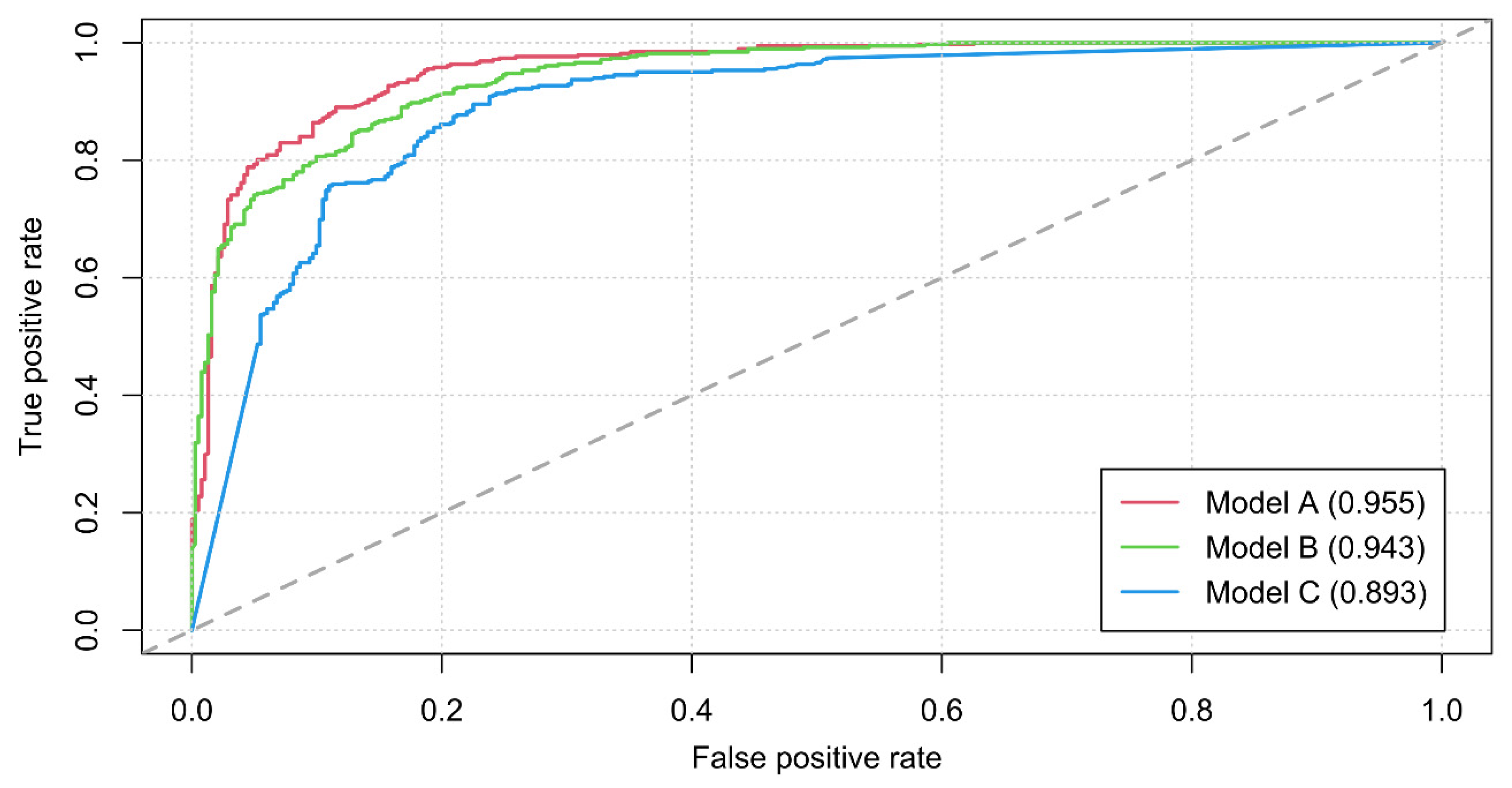
| Model | 100%-OOB Error | Test | AUC |
|---|---|---|---|
| Model A | 88.48% | 89.26% | 95.5% |
| Model B | 86.78% | 88.34% | 94.3% |
| Model C | 81.68% | 84.97% | 89.3% |
| MODEL A | ||||
| Rank | Conditioning Factor | MDA | Conditioning Factor | MDG |
| 1 | Drainage Density | 53.19 | Drainage Density | 92.82 |
| 2 | Land use land cover (LULC) | 40.97 | Land use land cover (LULC) | 62.83 |
| 3 | Elevation | 23.90 | Elevation | 43.13 |
| 4 | Slope aspect | 23.51 | Slope degree | 36.39 |
| 5 | Distance to residential areas | 21.13 | Slope aspect | 24.11 |
| 6 | Slope degree | 17.85 | Distance to pathways | 23.41 |
| 7 | Normalized Difference Vegetation Index (NDVI) | 14.22 | Distance to residential areas | 16.43 |
| 8 | Distance to pathways | 12.76 | Curvature/landforms | 14.05 |
| 9 | Distance to river | 8.38 | Slope length and steepness (LS) | 13.85 |
| 10 | Convergence Index (CI) | 8.23 | Convergence Index (CI) | 13.44 |
| 11 | Bedrock | 7.70 | Normalized Difference Vegetation Index (NDVI) | 12.48 |
| 12 | Soil | 7.64 | Topographic Wetness Index (TWI) | 7.60 |
| 13 | Curvature/landforms | 7.40 | Bedrock | 7.02 |
| 14 | Topographic Wetness Index (TWI) | 5.79 | Distance to river | 4.09 |
| 15 | Slope length and steepness (LS) | 5.06 | Soil | 2.72 |
| 16 | Stream Power Index (SPI) | 1.30 | Stream Power Index (SPI) | 1.26 |
| MODEL B | ||||
| 1 | Drainage Density | 66.17 | Drainage Density | 98.28 |
| 2 | Elevation | 32.37 | Elevation | 55.37 |
| 3 | Slope aspect | 25.07 | Slope degree | 50.56 |
| 4 | Normalized Difference Vegetation Index (NDVI) | 23.83 | Slope aspect | 28.64 |
| 5 | Slope degree | 23.19 | Curvature/landforms | 18.92 |
| 6 | Convergence Index (CI) | 13.35 | Normalized Difference Vegetation Index (NDVI) | 18.62 |
| 7 | Bedrock | 12.37 | Slope length and steepness (LS) | 17.95 |
| 8 | Topographic Wetness Index (TWI) | 11.37 | Convergence Index (CI) | 17.78 |
| 9 | Distance to river | 9.81 | Bedrock | 14.04 |
| 10 | Curvature/landforms | 9.27 | Topographic Wetness Index (TWI) | 13.31 |
| 11 | Soil | 5.24 | Distance to river | 6.13 |
| 12 | Slope length and steepness (LS) | 4.27 | Soil | 2.93 |
| 13 | Stream Power Index (SPI) | 1.39 | Stream Power Index (SPI) | 1.55 |
| MODEL C | ||||
| 1 | Land use land cover (LULC) | 160.06 | Land use land cover (LULC) | 169.47 |
| 2 | Distance to residential areas | 31.60 | Distance to residential areas | 39.95 |
| 3 | Distance to pathways | 23.74 | Distance to pathways | 38.19 |
Publisher’s Note: MDPI stays neutral with regard to jurisdictional claims in published maps and institutional affiliations. |
© 2021 by the authors. Licensee MDPI, Basel, Switzerland. This article is an open access article distributed under the terms and conditions of the Creative Commons Attribution (CC BY) license (https://creativecommons.org/licenses/by/4.0/).
Share and Cite
Busch, R.; Hardt, J.; Nir, N.; Schütt, B. Modeling Gully Erosion Susceptibility to Evaluate Human Impact on a Local Landscape System in Tigray, Ethiopia. Remote Sens. 2021, 13, 2009. https://doi.org/10.3390/rs13102009
Busch R, Hardt J, Nir N, Schütt B. Modeling Gully Erosion Susceptibility to Evaluate Human Impact on a Local Landscape System in Tigray, Ethiopia. Remote Sensing. 2021; 13(10):2009. https://doi.org/10.3390/rs13102009
Chicago/Turabian StyleBusch, Robert, Jacob Hardt, Nadav Nir, and Brigitta Schütt. 2021. "Modeling Gully Erosion Susceptibility to Evaluate Human Impact on a Local Landscape System in Tigray, Ethiopia" Remote Sensing 13, no. 10: 2009. https://doi.org/10.3390/rs13102009
APA StyleBusch, R., Hardt, J., Nir, N., & Schütt, B. (2021). Modeling Gully Erosion Susceptibility to Evaluate Human Impact on a Local Landscape System in Tigray, Ethiopia. Remote Sensing, 13(10), 2009. https://doi.org/10.3390/rs13102009


