Dynamic Divide Migration as a Response to Asymmetric Uplift: An Example from the Zhongtiao Shan, North China
Abstract
1. Introduction
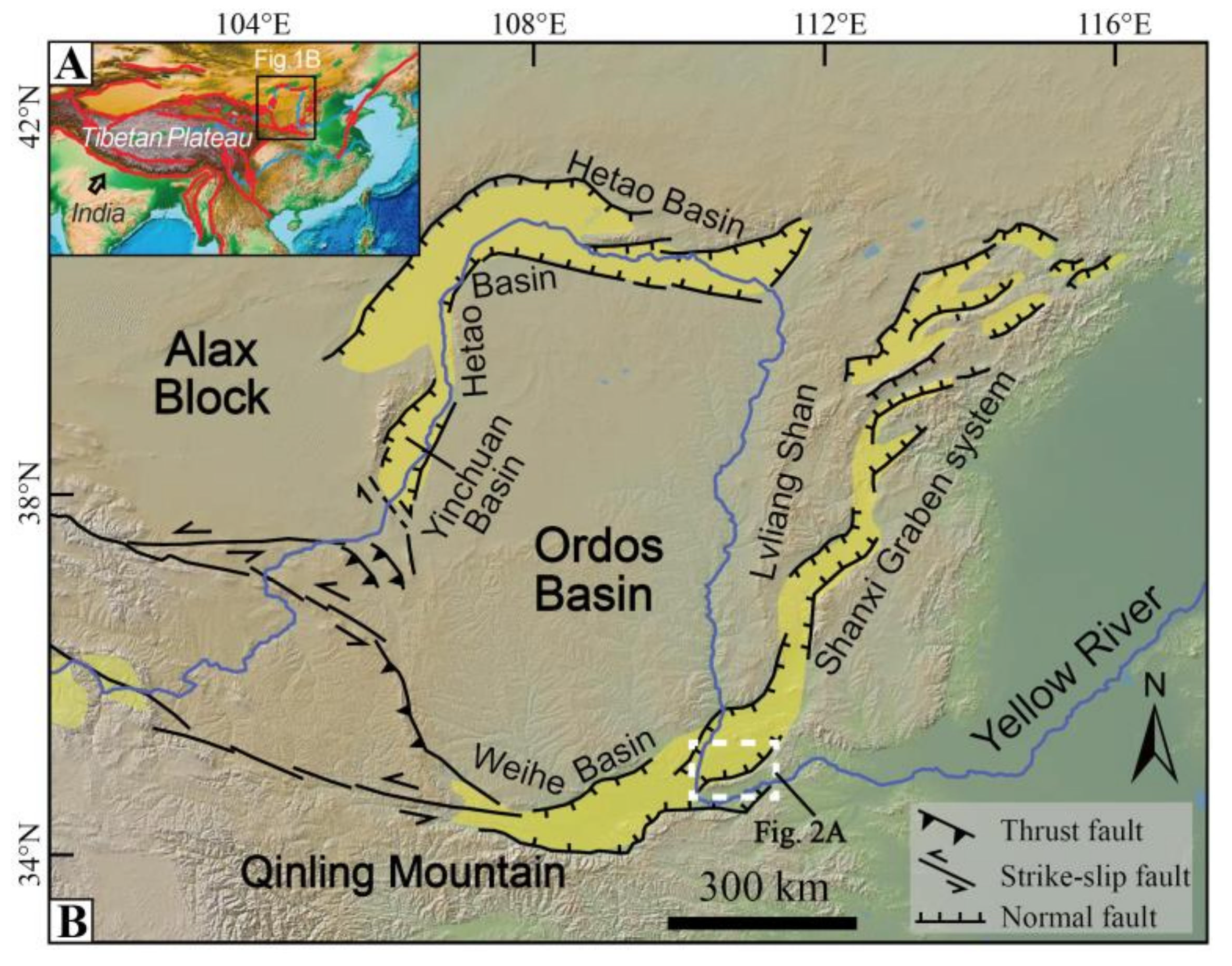
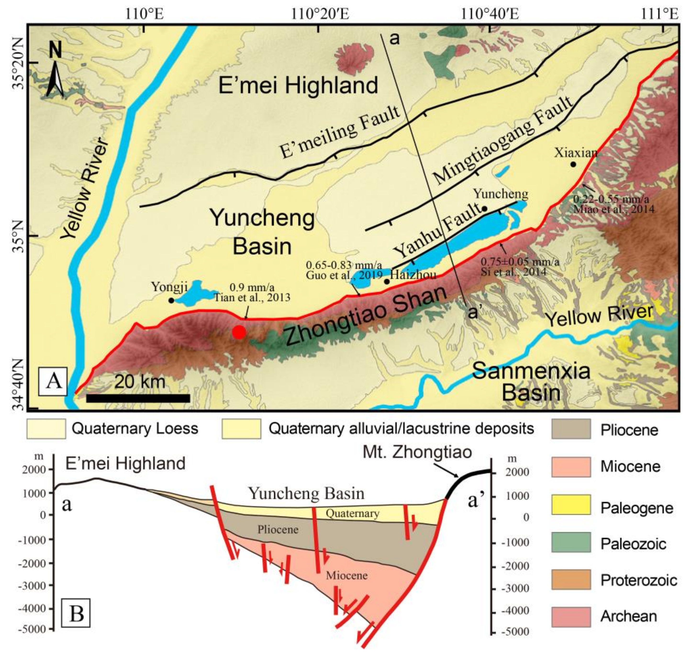
2. Background Setting
3. Methods
3.1. Channel Steepness
3.2. Gilbert Metrics and χ
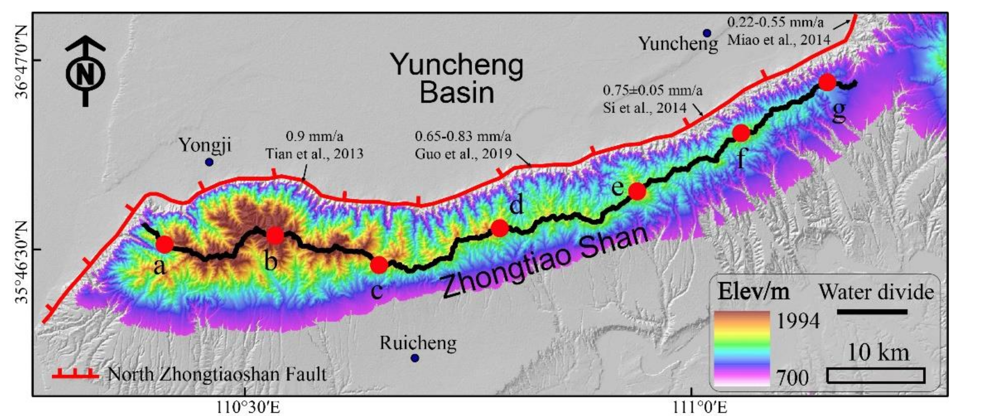
4. Results
4.1. Topographic Steepness and Slope
4.2. Gilbert Metrics and χ
5. Discussion
5.1. Asymmetric Uplift and Erosion
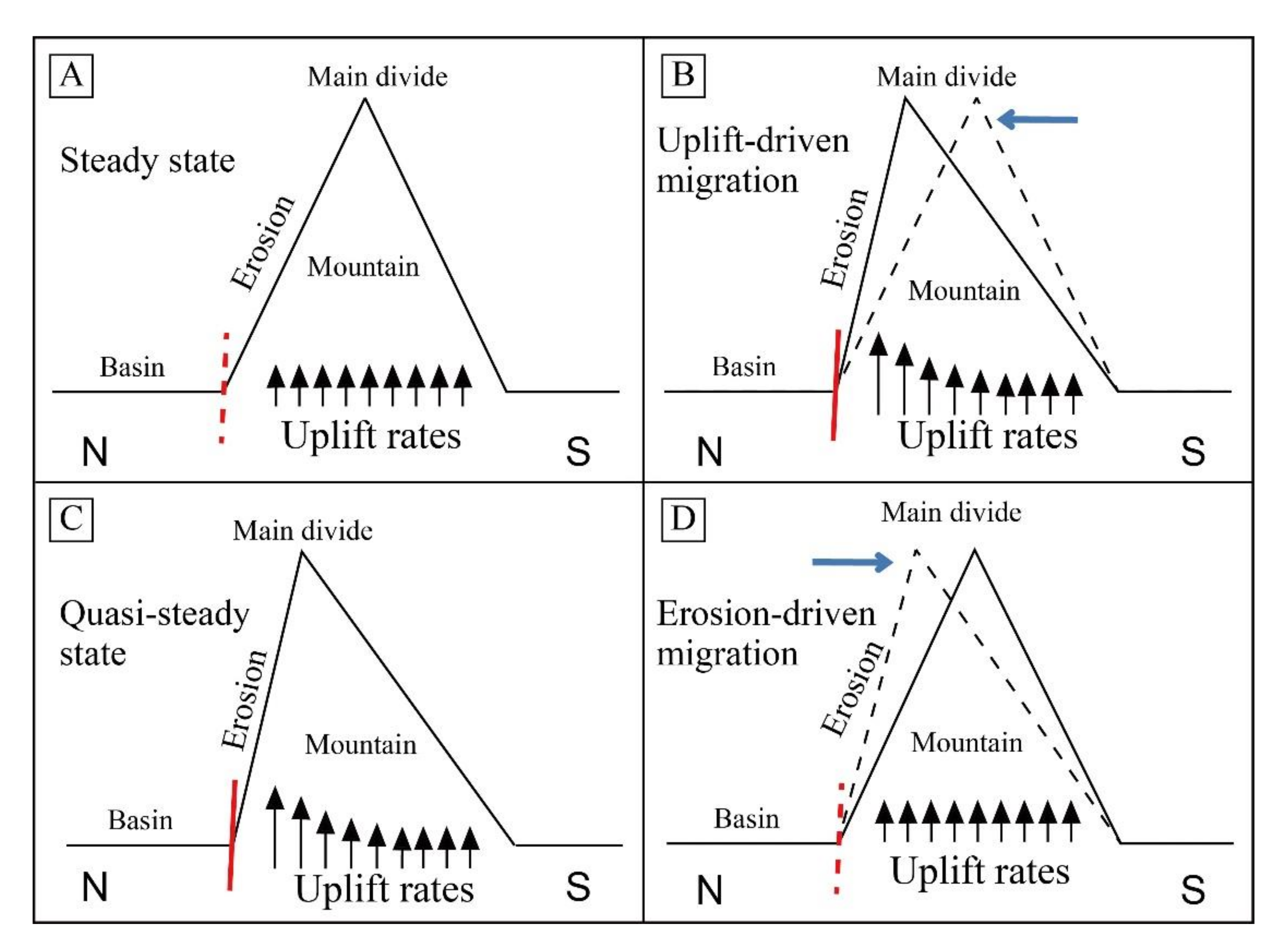
5.2. The Model of Dynamic Divide Migration
5.3. Fault Activity History
6. Conclusions
- (1)
- It is the relative value of the uplift and erosion that controls the migration and stabilization of the main divide in the asymmetric uplift pattern.
- (2)
- When the uplift outperforms the erosion on the fault-uplift side (i.e., footwall block of normal faults), the divide will migrate towards the higher uplift flank. Conversely, the divide will migrate backwards. When the erosion balances the uplift, the landscape system will finally reach a quasi-steady state.
- (3)
- The Zhongtiao Shan is experiencing the asymmetric uplift, with higher uplift and erosion on its northern flank.
- (4)
- The eastern segment of the NZTF must have experienced higher activities in the geological history, and the western fault may remain its slip rate along with the mountain relief generation.
Author Contributions
Funding
Acknowledgments
Conflicts of Interest
References
- Gilbert, G.K. Geology of the Henry Mountains; Government Printing Office: Washington, DC, USA, 1877. [Google Scholar]
- Willett, S.D.; Mccoy, S.W.; Perron, J.T.; Goren, L.; Chen, C.Y. Dynamic reorganization of river basins. Science 2014, 343, 1248765. [Google Scholar] [CrossRef] [PubMed]
- Bonnet, S. Shrinking and splitting of drainage basins in orogenic landscapes from the migration of the main drainage divide. Nat. Geosci. 2009, 2, 766–771. [Google Scholar] [CrossRef]
- Scherler, D.; Schwanghart, W. Drainage divide networks-Part 2: Response to perturbations. Earth Surf. Dyn. 2020, 8, 261–274. [Google Scholar] [CrossRef]
- Stark, C.P. Oscillatory motion of drainage divides. Geophys. Res. Lett. 2010, 37, L04401. [Google Scholar] [CrossRef]
- Whipple, K.X.; Forte, A.M.; Dibiase, R.A.; Gasparini, N.M.; Ouimet, W.B. Timescales of landscape response to divide migration and drainage capture: Implications for the role of divide mobility in landscape evolution. J. Geophys. Res. Earth Surf. 2017, 122, 248–273. [Google Scholar] [CrossRef]
- Kim, D.-E.; Seong, Y.B.; Weber, J.; Yu, B.Y. Unsteady migration of Taebaek Mountain drainage divide, Cenozoic extensional basin margin, Korean Peninsula. Geomorphology 2020, 352, 107012. [Google Scholar] [CrossRef]
- Lima, S.M.Q.; Berbel-Filho, W.M.; Araujo, T.F.P.; Lazzarotto, H.; Tatarenkov, A.; Avise, J.C. Headwater Capture Evidenced by Paleo-Rivers Reconstruction and Population Genetic Structure of the Armored Catfish (Pareiorhaphis garbei) in the Serra do Mar Mountains of Southeastern Brazil. Front. Genet. 2017, 8, 199. [Google Scholar] [CrossRef]
- He, C.; Rao, G.; Yang, R.; Hu, J.; Yao, Q.; Yang, C.-J. Divide migration in response to asymmetric uplift: Insights from the Wula Shan horst, North China. Geomorphology 2019, 339, 44–57. [Google Scholar] [CrossRef]
- Stokes, M.; Mather, A.; Harvey, A. Quantification of river-capture-induced base-level changes and landscape development, Sorbas Basin, SE Spain. Geol. Soc. Lond. Spec. Publ. 2002, 191, 23–35. [Google Scholar] [CrossRef]
- Struth, L.; Teixell, A.; Owen, L.A.; Babault, J. Plateau reduction by drainage divide migration in the Eastern Cordillera of Colombia defined by morphometry and 10Be terrestrial cosmogenic nuclides. Earth Surf. Process. Landf. 2017, 42, 1155–1170. [Google Scholar] [CrossRef]
- Lyons, N.J.; Val, P.; Albert, J.S.; Willenbring, J.K.; Gasparini, N.M. Topographic controls on divide migration, stream capture, and diversification in riverine life. Earth Surf. Dyn. 2020, 8, 893–912. [Google Scholar] [CrossRef]
- Willett, S.D.; McCoy, S.W.; Beeson, H.W. Transience of the North American High Plains landscape and its impact on surface water. Nature 2018, 561, 528–532. [Google Scholar] [CrossRef] [PubMed]
- Forte, A.M.; Whipple, K.X. Criteria and tools for determining drainage divide stability. Earth Planet. Sci. Lett. 2018, 493, 102–117. [Google Scholar] [CrossRef]
- Goren, L.; Willett, S.D.; Herman, F.; Braun, J. Coupled numerical-analytical approach to landscape evolution modeling. Earth Surf. Process. Landf. 2014, 39, 522–545. [Google Scholar] [CrossRef]
- Scherler, D.; Schwanghart, W. Drainage divide networks-Part 1: Identification and ordering in digital elevation models. Earth Surf. Dyn. 2020, 8, 245–259. [Google Scholar] [CrossRef]
- Yang, R.; Willett, S.D.; Goren, L. In situ low-relief landscape formation as a result of river network disruption. Nature 2015, 520, 526–529. [Google Scholar] [CrossRef]
- Sinclair, H.D.; Mudd, S.M.; Dingle, E.; Hobley, D.E.J.; Robinson, R.; Walcott, R. Squeezing river catchments through tectonics: Shortening and erosion across the Indus Valley, NW Himalaya. Geol. Soc. Am. Bull. 2017, 129, 203–217. [Google Scholar] [CrossRef]
- Cooper, A.F.; Beck, R.J. River capture and Main Divide migration in the Haast River catchment assessed from the fluvial distribution of sodalite-bearing dike rocks and fenites. N. Z. J. Geol. Geophys. 2009, 52, 27–36. [Google Scholar] [CrossRef]
- Buscher, J.T.; Ascione, A.; Valente, E. Decoding the role of tectonics, incision and lithology on drainage divide migration in the Mt. Alpi region, southern Apennines, Italy. Geomorphology 2017, 276, 37–50. [Google Scholar] [CrossRef]
- Forte, A.M.; Whipple, K.X.; Cowgill, E. Drainage network reveals patterns and history of active deformation in the eastern Greater Caucasus. Geosphere 2015, 11, 1343–1364. [Google Scholar] [CrossRef]
- Dahlquist, M.P.; West, A.J.; Li, G. Landslide-driven drainage divide migration. Geology 2018, 46, 403–406. [Google Scholar] [CrossRef]
- Wang, J.; Howarth, J.D.; McClymont, E.L.; Densmore, A.L.; Fitzsimons, S.J.; Croissant, T.; Gröcke, D.R.; West, M.D.; Harvey, E.L.; Frith, N.V.; et al. Long-term patterns of hillslope erosion by earthquake-induced landslides shape mountain landscapes. Sci. Adv. 2020, 6, eaaz6446. [Google Scholar] [CrossRef] [PubMed]
- Guerit, L.; Goren, L.; Dominguez, S.; Malavieille, J.; Castelltort, S. Landscape ‘stress’ and reorganization from χ-maps: Insights from experimental drainage networks in oblique collision setting. Earth Surf. Process. Landf. 2018, 43, 3152–3163. [Google Scholar] [CrossRef]
- Yan, J.; Hu, J.; Gong, W.; Liu, X.; Yin, Y.; Tan, C. Late Cenozoic magnetostratigraphy of the Yuncheng Basin, central North China Craton and its tectonic implications. Geol. J. 2020, 55, 7415–7428. [Google Scholar] [CrossRef]
- Yang, C.; Zhang, F.; Liu, R.; Hou, J.; Zhang, Q.; Zhao, C. Ground deformation and fissure activity of the Yuncheng Basin (China) revealed by multiband time series InSAR. Adv. Space Res. 2020, 66, 490–504. [Google Scholar] [CrossRef]
- Xiong, J.; Li, Y.; Zheng, W.; Zhang, P.; Lei, J.; Zhong, Y.; Hu, X.; Li, Z.; Gong, Z.; Li, T.; et al. Climatically driven formation of the Tangxian planation surface in North China: An example from northwestern Zhongtiao Shan of the Shanxi Graben System. Lithosphere 2018, 10, 530–544. [Google Scholar] [CrossRef]
- Li, X.; Zhang, H.; Wang, Y.; Zhao, X.; Ma, Z.; Liu, K.; Ma, Y. Inversion of bedrock channel profiles in the Daqing Shan in Inner Mongolia, northern China: Implications for late Cenozoic tectonic history in the Hetao Basin and the Yellow River evolution. Tectonophysics 2020, 790. [Google Scholar] [CrossRef]
- Shi, W.; Dong, S.; Hu, J. Neotectonics around the Ordos Block, North China: A review and new insights. Earth-Sci. Rev. 2020, 200, 102969. [Google Scholar] [CrossRef]
- Middleton, T.A.; Elliott, J.R.; Rhodes, E.J.; Sherlock, S.; Walker, R.T.; Wang, W.; Yu, J.; Zhou, Y. Extension rates across the northern Shanxi Grabens, China, from Quaternary geology, seismicity and geodesy. Geophys. J. Int. 2017. [Google Scholar] [CrossRef]
- Clinkscales, C.; Kapp, P.; Wang, H. Exhumation history of the north-central Shanxi Rift, North China, revealed by low-temperature thermochronology. Earth Planet. Sci. Lett. 2020, 536, 116146. [Google Scholar] [CrossRef]
- Liu, J.; Zhang, P.; Zheng, D.; Wan, J.; Wang, W.; Du, P.; Lei, Q. Pattern and timing of late Cenozoic rapid exhumation and uplift of the Helan Mountain, China. Sci. China Earth Sci. 2010, 53, 345–355. [Google Scholar] [CrossRef]
- Shi, W.; Cen, M.; Chen, L.; Wang, Y.; Chen, X.; Li, J.; Chen, P. Evolution of the late Cenozoic tectonic stress regime in the Shanxi Rift, central North China Plate inferred from new fault kinematic analysis. J. Asian Earth Sci. 2015, 114, 54–72. [Google Scholar] [CrossRef]
- Si, S.; Li, Y.; Lü, S.; Wang, Y. Holocene slip rate and paleoearthquake records of the Salt Lake segment of the Northern Zhongtiaoshan Fault, Shanxi Province. Sci. China Earth Sci. 2014, 57, 2079–2088. [Google Scholar] [CrossRef]
- Guo, C.; Li, W.; Tian, Q.; Xu, Y.; Du, P.; Liu, S. Study on Lte Pleistocene Rate of Haizhou Section of North Zhongtiaoshan Fault. Earthquake 2019, 39, 13–26. [Google Scholar]
- Tian, J.; Li, Y.; Si, S.; Lv, S.; Wang, Y. Discovery and Neotectonic Significance of Fault Scarps on Alluvial Fans in the Middle of Northern Piedmont of the Zhongtiao Mountains. Acta Sci. Nat. Univ. Pekin. 2013, 49, 986–992. [Google Scholar]
- Lv, S.; Li, Y.; Wang, Y.; Ci, H. The Holocene paleoseismicity of the North Zhongtiaoshan Faults in Shanxi Province, China. Tectonophysics 2014, 623, 67–82. [Google Scholar] [CrossRef]
- Xiong, J.; Li, Y.; Si, S.; Lv, S.; Wang, Y.; Zhong, Y.; Xin, W.; Ci, H. A rock fall of the north Zhongtiao Shan fault and the Yongji earthquake in 793, Shanxi Province, North China. Arab. J. Geosci. 2016, 9, 704. [Google Scholar] [CrossRef]
- Cheng, S.; Yang, G. Late Quaternary Segment ation Model of the Zhongtiaoshan Fault, Shanxi Province. Seismol. Geol. 2002, 24, 289–302. [Google Scholar]
- Wang, Q.; Li, G.; Tian, G.; Zhang, W.; Liu, C.; Ning, L.; Yue, J.; Cheng, Z.; He, C. Tremendous change of the earth surface system and tectonic setting of salt-lake formation in Yuncheng Basin since 7.1 Ma. Sci. China Ser. D 2002, 45, 110–122. [Google Scholar] [CrossRef]
- Shi, W.; Chen, L.; Chen, X.; Cen, M.; Zhang, Y. The Cenozoic tectonic evolution of the faulted basins in the northern margin of the Eastern Qinling Mountains, Central China: Constraints from fault kinematic analysis. J. Asian Earth Sci. 2019, 173, 204–224. [Google Scholar] [CrossRef]
- Kirby, E.; Whipple, K.X. Expression of active tectonics in erosional landscapes. J. Struct. Geol. 2012, 44, 54–75. [Google Scholar] [CrossRef]
- Wobus, C.; Whipple, K.X.; Kirby, E.; Snyder, N.; Johnson, J.; Spyropolou, K.; Crosby, B.; Sheehan, D. Tectonics from topography: Procedures, promise, and pitfalls. Spec. Pap. Geol. Soc. Am. 2006, 398, 55–74. [Google Scholar] [CrossRef]
- Whipple, K.X. Bedrock rivers and the geomorphology of active orogens. Annu. Rev. Earth Planet. Sci. 2004, 32, 151–185. [Google Scholar] [CrossRef]
- Hu, X.; Pan, B.; Kirby, E.; Li, Q.; Geng, H.; Chen, J. Spatial differences in rock uplift rates inferred from channel steepness indices along the northern flank of the Qilian Mountain, northeast Tibetan Plateau. Chin. Sci. Bull. 2010, 55, 3205–3214. [Google Scholar] [CrossRef]
- Kirby, E.; Whipple, K. Quantifying differential rock-uplift rates via stream profile analysis. Geology 2001, 29, 415–418. [Google Scholar] [CrossRef]
- Howard, A.D.; Dietrich, W.E.; Seidl, M.A. Modeling fluvial erosion on regional to continental scales. J. Geophys. Res. 1994, 99, 13971–13986. [Google Scholar] [CrossRef]
- Whipple, K.X.; Tucker, G.E. Dynamics of the stream-power river incision model: Implications for height limits of mountain ranges, landscape response timescales, and research needs. J. Geophys. Res. Solid Earth 1999, 104, 17661–17674. [Google Scholar] [CrossRef]
- Wang, Y.; Zhang, H.; Zheng, D.; Yu, J.; Pang, J.; Ma, Y. Coupling slope–area analysis, integral approach and statistic tests to steady-state bedrock river profile analysis. Earth Surf. Dyn. 2017, 5, 145–160. [Google Scholar] [CrossRef]
- Perron, J.T.; Royden, L. An integral approach to bedrock river profile analysis. Earth Surf. Process. Landf. 2013, 38, 570–576. [Google Scholar] [CrossRef]
- Royden, L.; Perron, T. Solutions of the stream power equation and application to the evolution of river longitudinal profiles. J. Geophys. Res. Earth Surf. 2013, 118, 497–518. [Google Scholar] [CrossRef]
- Gallen, S.F.; Wegmann, K.W. River profile response to normal fault growth and linkage: An example from the Hellenic forearc of south-central Crete, Greece. Earth Surf. Dyn. 2017, 5, 161–186. [Google Scholar] [CrossRef]
- Winterberg, S.; Willett, S.D. Greater Alpine river network evolution, interpretations based on novel drainage analysis. Swiss J. Geosci. 2019, 112, 3–22. [Google Scholar] [CrossRef] [PubMed]
- Chen, C.-Y.; Willett, S.D. Graphical methods of river profile analysis to unravel drainage area change, uplift and erodibility contrasts in the Central Range of Taiwan. Earth Surf. Process. Landf. 2016, 41, 2223–2238. [Google Scholar] [CrossRef]
- Forte, A.M.; Whipple, K.X. Short communication: The Topographic Analysis Kit (TAK) for TopoToolbox. Earth Surf. Dyn. 2019, 7, 87–95. [Google Scholar] [CrossRef]
- Schwanghart, W.; Scherler, D. Short Communication: TopoToolbox 2–MATLAB-based software for topographic analysis and modeling in Earth surface sciences. Earth Surf. Dyn. 2014, 2, 1–7. [Google Scholar] [CrossRef]
- Trost, G.; Robl, J.; Hergarten, S.; Neubauer, F. The destiny of orogen-parallel streams in the Eastern Alps: The Salzach-Enns drainage system. Earth Surf. Dyn. 2020, 8, 69–85. [Google Scholar] [CrossRef]
- Miao, D.; Li, Y.; Lv, S.; Tian, J.; Wang, Y.; Si, S. Neotectonic activity in Xiaxian segment of the North Zhongtiao Mountain Fault Zone, Shanxi. Geogr. Res. 2014, 33, 665–673. [Google Scholar] [CrossRef]
- Zhang, H.-p.; Zhang, P.-z.; Kirby, E.; Yin, J.-h.; Liu, C.-r.; Yu, G.-h. Along-strike topographic variation of the Longmen Shan and its significance for landscape evolution along the eastern Tibetan Plateau. J. Asian Earth Sci. 2011, 40, 855–864. [Google Scholar] [CrossRef]
- Su, Q.; Xie, H.; Yuan, D.-Y.; Zhang, H.-P. Along-strike topographic variation of Qinghai Nanshan and its significance for landscape evolution in the northeastern Tibetan Plateau. J. Asian Earth Sci. 2017, 147, 226–239. [Google Scholar] [CrossRef]
- Harkins, N.; Kirby, E.; Heimsath, A.; Robinson, R.; Reiser, U. Transient fluvial incision in the headwaters of the Yellow River, northeastern Tibet, China. J. Geophys. Res. 2007, 112, 112.F3. [Google Scholar] [CrossRef]
- Whipple, K.X.; Shirzaei, M.; Hodges, K.V.; Arrowsmith, J.R. Active shortening within the Himalayan orogenic wedge implied by the 2015 Gorkha earthquake. Nat. Geosci. 2016, 9, 711–716. [Google Scholar] [CrossRef]
- Montgomery, D.R.; Brandon, M.T. Topographic controls on erosion rates in tectonically active mountain ranges. Earth Planet. Sci. Lett. 2002, 201, 481–489. [Google Scholar] [CrossRef]
- Portenga, E.W.; Bierman, P.R. Understanding Earth’s eroding surface with 10Be. GSA Today 2011, 21, 4–10. [Google Scholar] [CrossRef]
- Delunel, R.; Schlunegger, F.; Valla, P.G.; Dixon, J.; Glotzbach, C.; Hippe, K.; Kober, F.; Molliex, S.; Norton, K.P.; Salcher, B.; et al. Late-Pleistocene catchment-wide denudation patterns across the European Alps. Earth-Sci. Rev. 2020, 211, 103407. [Google Scholar] [CrossRef]
- Wobus, C.W. Geomorphic and Thermochronologic Signatures of Active Tectonics in the Central Nepalese Himalaya; Massachusetts Institute of Technology: Cambridge, MA, USA, 2005. [Google Scholar]
- Yang, C.-s.; Zhang, Q.; Xu, Q.; Zhao, C.-y.; Peng, J.-b.; Ji, L.-y. Complex Deformation Monitoring over the Linfen–Yuncheng Basin (China) with Time Series InSAR Technology. Remote Sens. 2016, 8, 248. [Google Scholar] [CrossRef]
- Xiong, J. A Study on the Age of the Geomorphologic Surface with Magnetostratigraphy—Examples from the Jianshui Basin in Yunnan and Yuncheng Basin in Shanxi; Peking University: Beijing, China, 2016. [Google Scholar]
- Bonnet, S.; Crave, A. Landscape response to climate change: Insights from experimental modeling and implications for tectonic versus climatic uplift of topography. Geology 2003, 31, 123–126. [Google Scholar] [CrossRef]
- Moussirou, B.; Bonnet, S. Modulation of the erosion rate of an uplifting landscape by long-term climate change: An experimental investigation. Geomorphology 2018, 303, 456–466. [Google Scholar] [CrossRef]


Publisher’s Note: MDPI stays neutral with regard to jurisdictional claims in published maps and institutional affiliations. |
© 2020 by the authors. Licensee MDPI, Basel, Switzerland. This article is an open access article distributed under the terms and conditions of the Creative Commons Attribution (CC BY) license (http://creativecommons.org/licenses/by/4.0/).
Share and Cite
Su, Q.; Wang, X.; Lu, H.; Xie, H. Dynamic Divide Migration as a Response to Asymmetric Uplift: An Example from the Zhongtiao Shan, North China. Remote Sens. 2020, 12, 4188. https://doi.org/10.3390/rs12244188
Su Q, Wang X, Lu H, Xie H. Dynamic Divide Migration as a Response to Asymmetric Uplift: An Example from the Zhongtiao Shan, North China. Remote Sensing. 2020; 12(24):4188. https://doi.org/10.3390/rs12244188
Chicago/Turabian StyleSu, Qi, Xianyan Wang, Huayu Lu, and Hong Xie. 2020. "Dynamic Divide Migration as a Response to Asymmetric Uplift: An Example from the Zhongtiao Shan, North China" Remote Sensing 12, no. 24: 4188. https://doi.org/10.3390/rs12244188
APA StyleSu, Q., Wang, X., Lu, H., & Xie, H. (2020). Dynamic Divide Migration as a Response to Asymmetric Uplift: An Example from the Zhongtiao Shan, North China. Remote Sensing, 12(24), 4188. https://doi.org/10.3390/rs12244188


