Imaging of the Upper Mantle Beneath Southeast Asia: Constrained by Teleseismic P-Wave Tomography


Abstract
1. Introduction
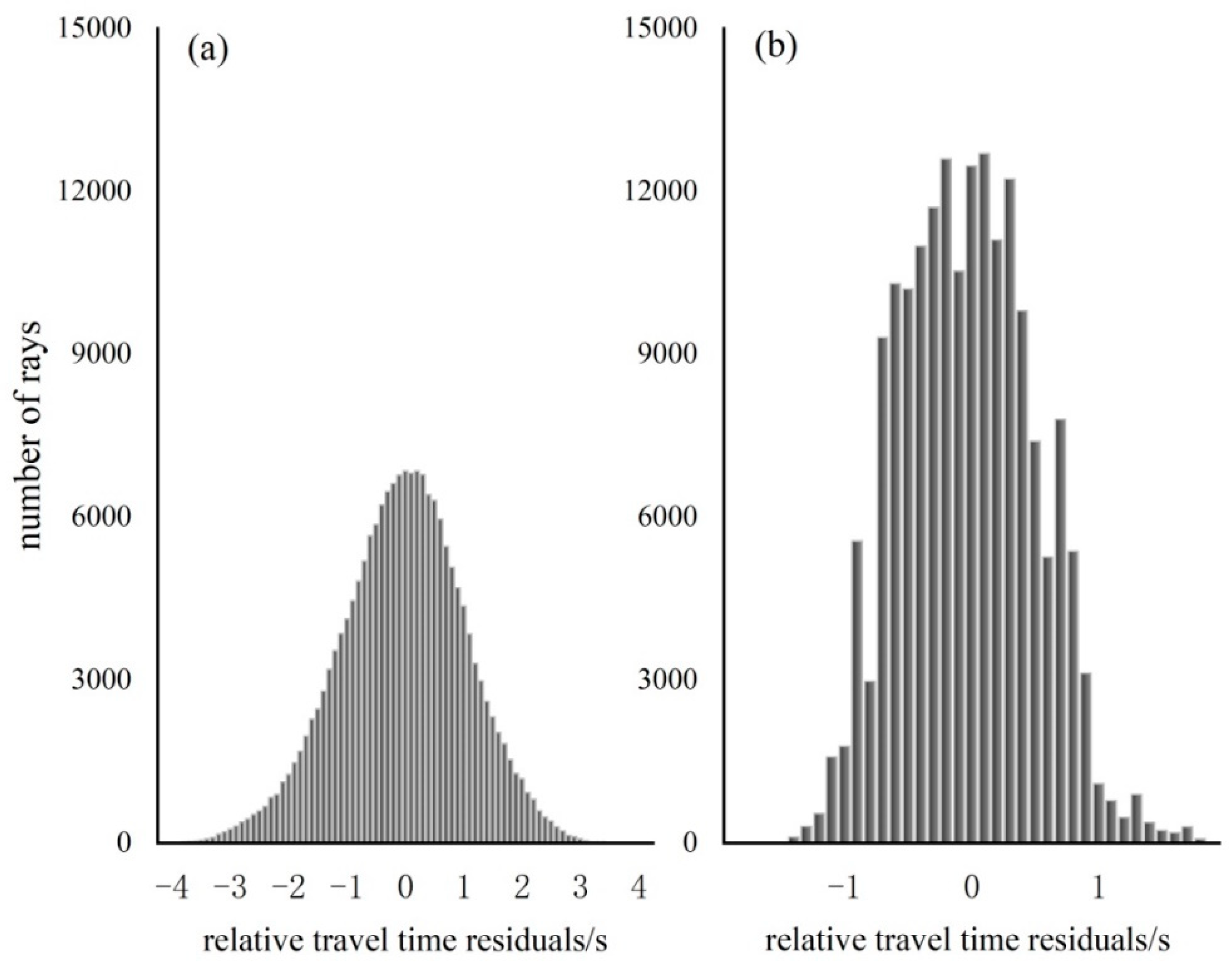
2. Data
3. Methodology
3.1. Model Parameterization
3.2. Forward Step
3.3. Inversion Step
4. Crust Correction
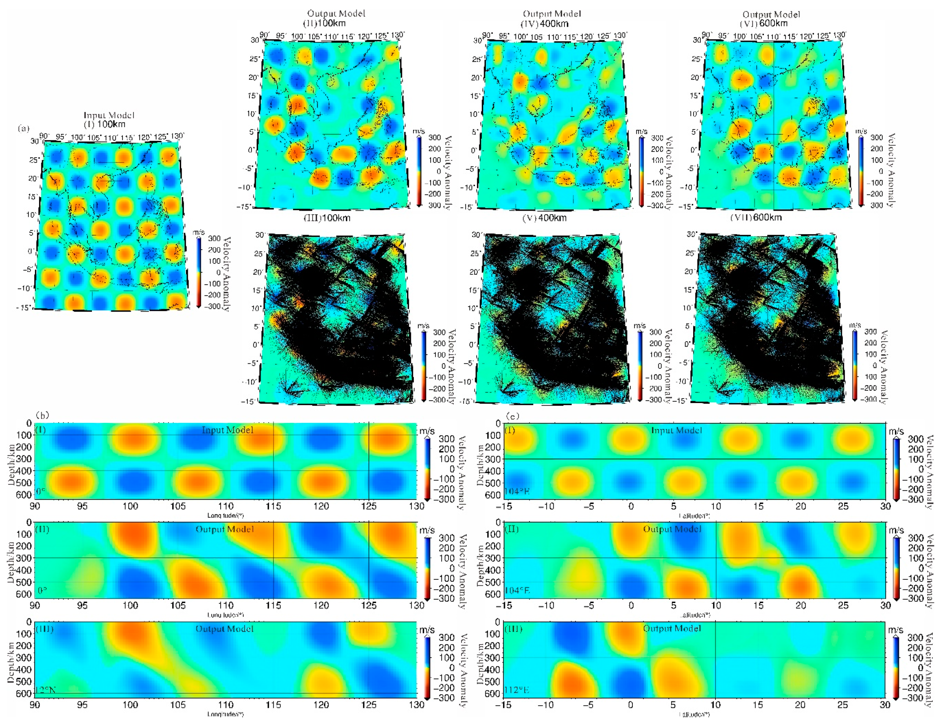
5. Resolution Test
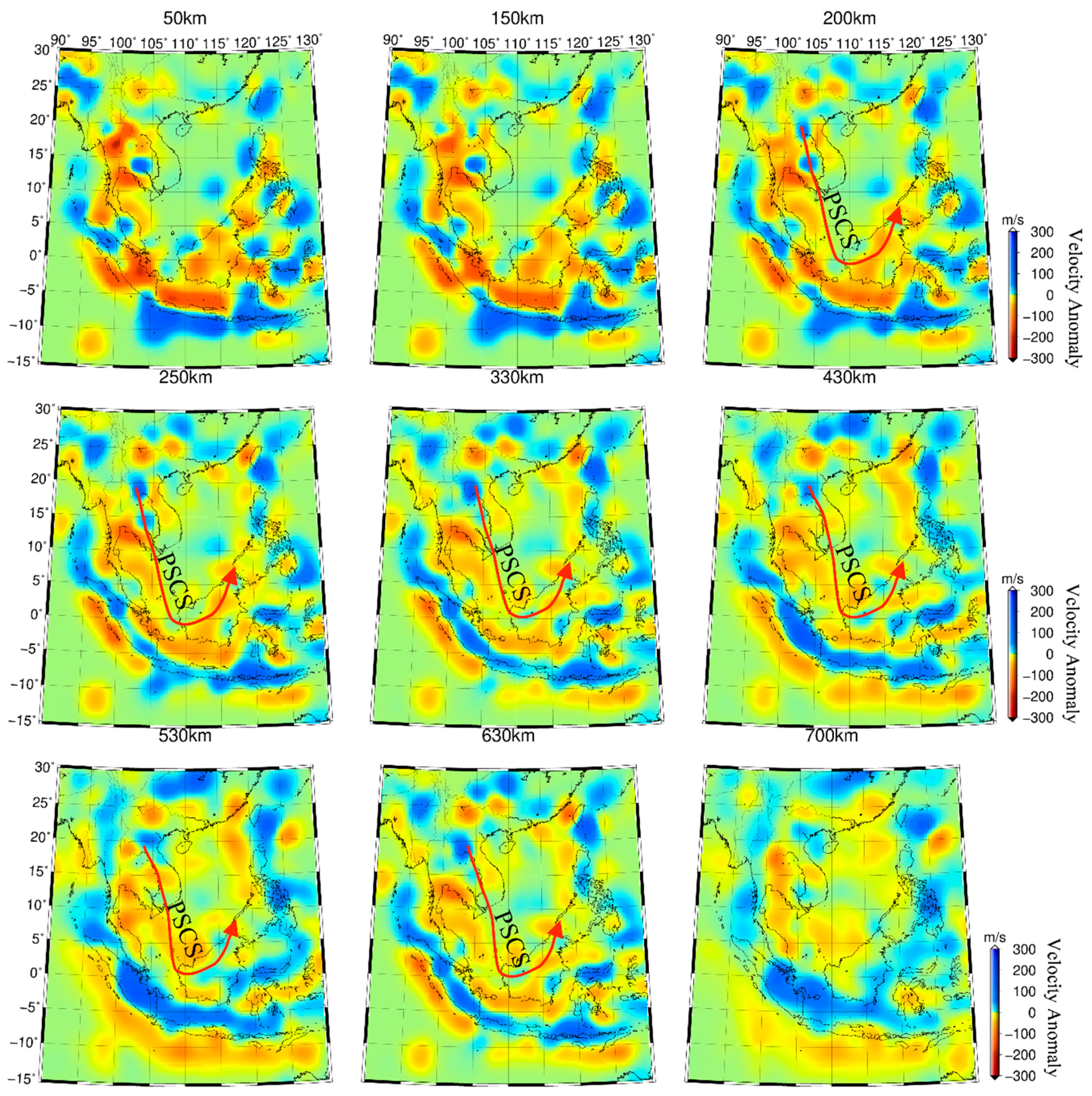
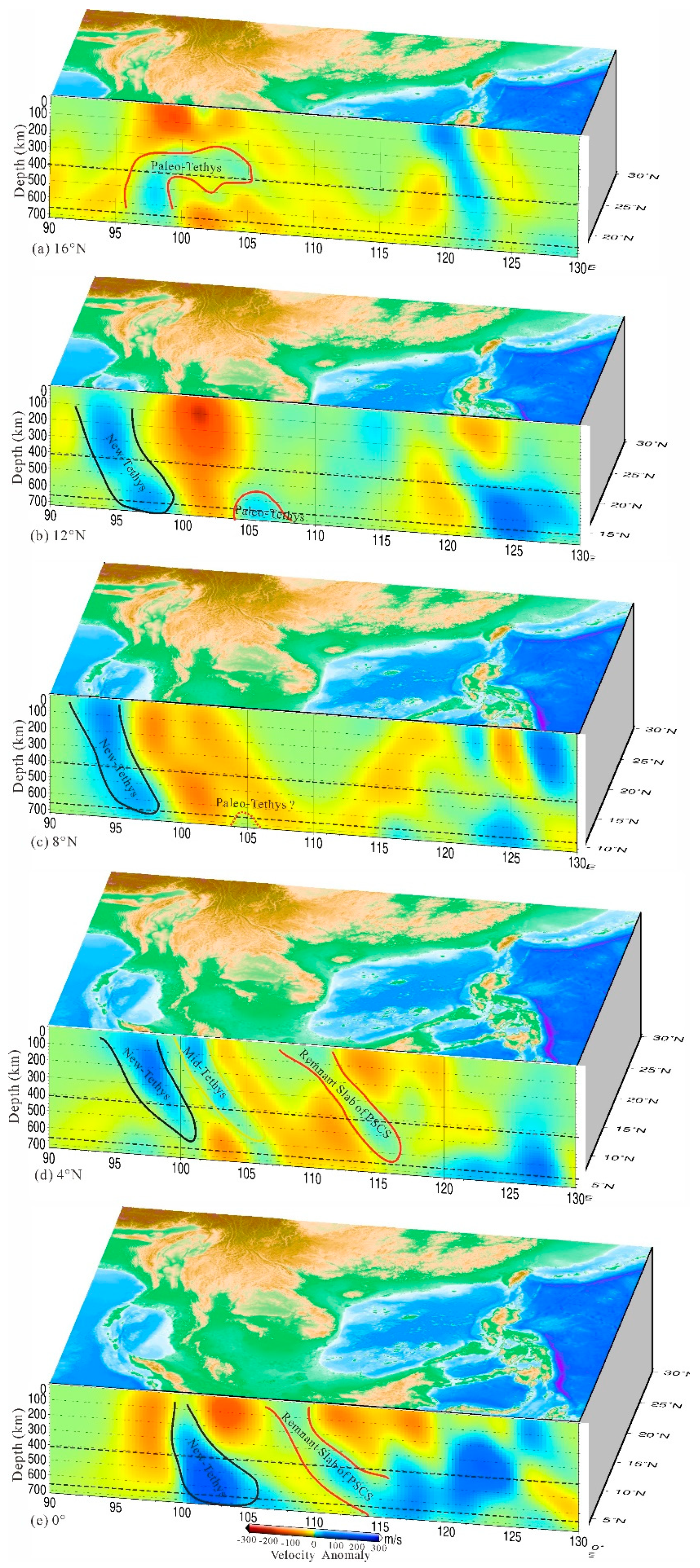
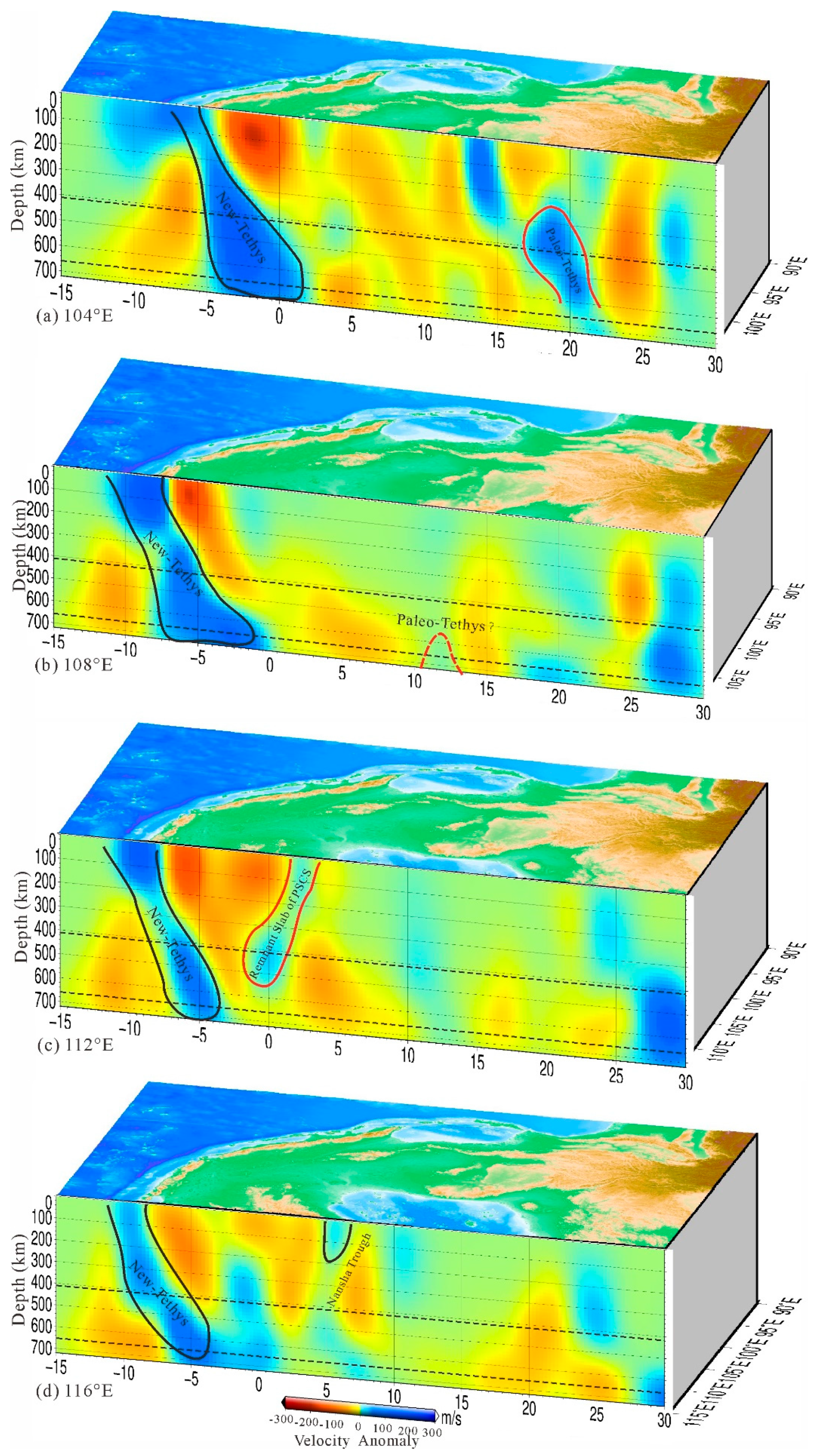
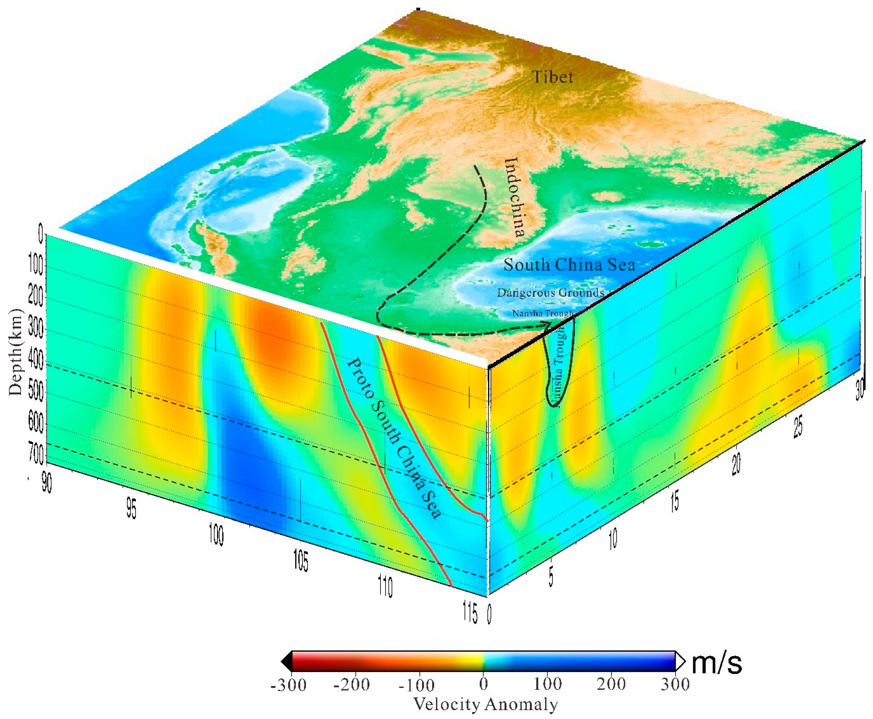
6. Results
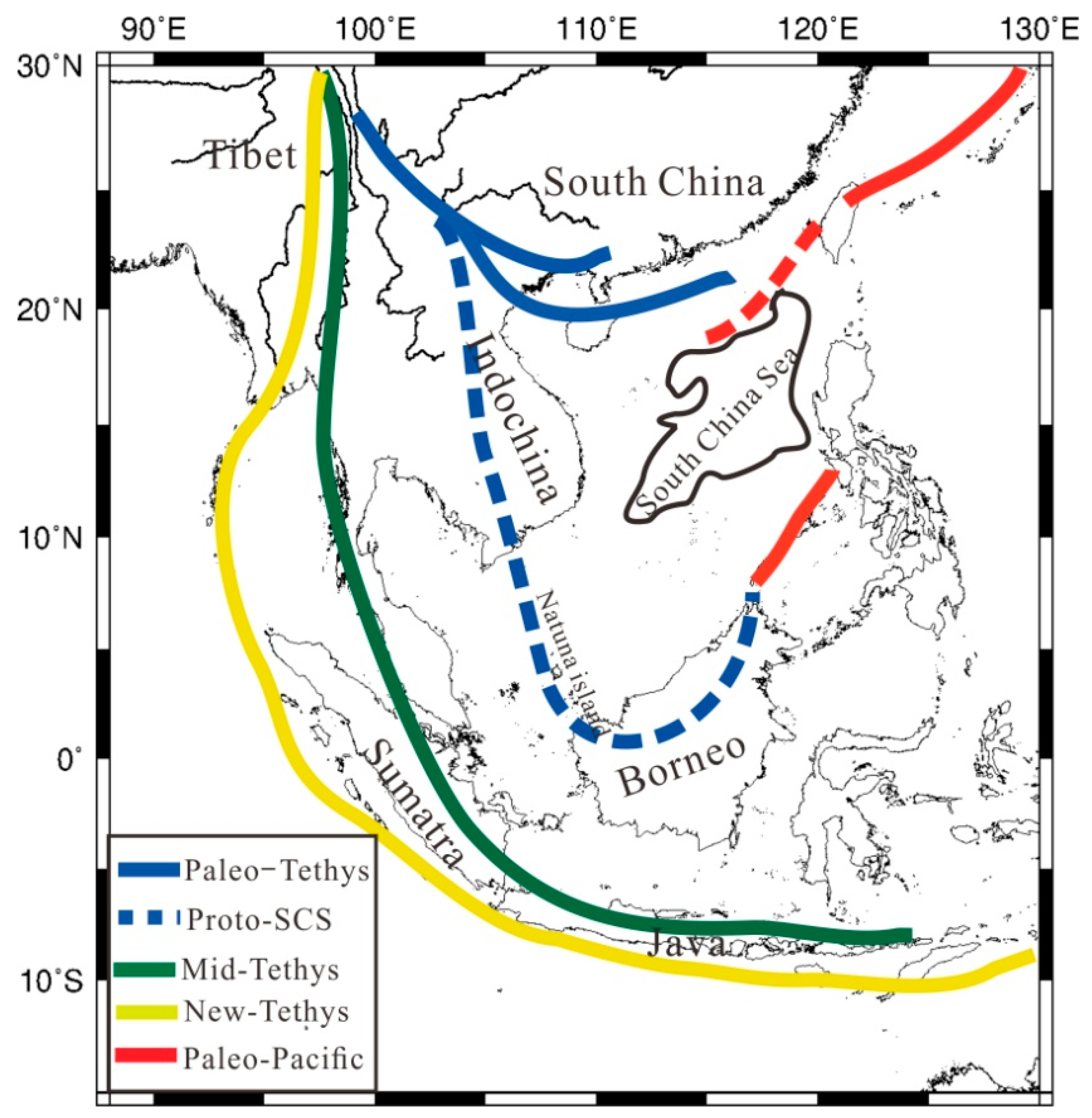
7. Discussion
8. Conclusions
Author Contributions
Funding
Acknowledgments
Conflicts of Interest
References
- Liu, H.; Xie, G.; Yan, P.; Liu, Y.; Zheng, H. Tectonic implication of Mesozoic marine deposits in the Nansha islands of the South China Sea. Oceanol. Limnol. Sin. 2007, 38, 272–278. [Google Scholar]
- Zhou, D.; Wu, S.; Chen, H. The dynamics of tectonic evolution in the Nansha sea area and adjacent areas. Earth Tecton. Mineral. 2005, 29, 339–345. [Google Scholar]
- Taylor, B.; Hayes, D.E. Origin, and History of the South China Sea Basin; John Wiley & Sons, Inc.: Hoboken, NJ, USA, 1983; pp. 23–56. [Google Scholar] [CrossRef]
- Holloway, N.H. North Palawan block, Philippines—Its relation to Asian mainland and role in evolution of south china sea. Bull. Am. Assoc. Petrol. Geol. 1982, 66, 1355–1383. [Google Scholar] [CrossRef]
- Hall, R. Contraction, and extension in northern Borneo driven by subduction rollback. J. Asian Earth Sci. 2013, 76, 399–411. [Google Scholar] [CrossRef]
- Hall, R.; van Hattum, M.W.A.; Spakman, W. Impact of India—Asia collision on SE Asia: The record in Borneo. Tectonophysics 2008, 451, 366–389. [Google Scholar] [CrossRef]
- Zahirovic, S.; Matthews, K.J.; Flament, N.; Müller, R.D.; Hill, K.C.; Seton, M.; Gurnwas, M. Tectonic evolution and deep mantle structure of the eastern Tethys since the latest Jurassic. Earth Sci. Rev. 2016, 162, 293–337. [Google Scholar] [CrossRef]
- Zhou, D.; Sun, Z. Plate evolution in the Pacific domain since Late Mesozoic and its inspiration to tectonic research of East Asia margin. J. Trop. Oceanogr. 2017, 36, 1–19. [Google Scholar]
- Fan, J.; Zhao, D.; Dong, D.; Zhang, G. P-wave tomography of subduction zones around the central Philippines and its geodynamic implications. J. Asian Earth Sci. 2017, 146, 76–89. [Google Scholar] [CrossRef]
- Wu, J.; Suppe, J. Proto-SCS Plate Tectonics Using Subducted Slab Constraints from Tomography. J. Earth Sci. 2017, 29, 1304–1318. [Google Scholar] [CrossRef]
- Wu, J.; Suppe, J.; Lu, R.; Kanda, R. Philippine Sea and East Asian plate tectonics since 52 Ma constrained by new subducted slab reconstruction methods. J. Geophys. Res. Solid Earth 2016, 121, 4670–4741. [Google Scholar] [CrossRef]
- Wu, S.; Zhou, D.; Liu, H. Tectonic framework and evolutionary characteristics of Nansha Block, South China Sea. Geotecton. Metallog. 2004, 28, 23–28. [Google Scholar]
- Zhou, D.; Sun, Z.; Chen, H. Mesozoic lithofacies, paleo-geography, and tectonic evolution of the South China Sea and surrounding areas. Earth Sci. Front. 2005, 12, 204–218. [Google Scholar]
- Metcalfe, I. Tectonic framework, and Phanerozoic evolution of Sundaland. Gondwana Res. 2011, 19, 3–21. [Google Scholar] [CrossRef]
- Lu, B.; Wang, P.; Liang, J.; Zhou, D.; Sun, Z.; Chen, H.Z.; Xu, H.H.; Wang, W.Y.; Pang, X.; Cai, D.S.; et al. Tectonic properties of the Proto-SCS and their relationship with the Tethys and Paleo-Pacific tectonic domains. J. Jilin Univ. Earth Sci. Ed. 2014, 4, 1441–1450. [Google Scholar]
- Müller, R.D.; Seton, M.; Zahirovic, S.; Williams, S.E.; Matthews, K.J.; Wright, N.M.; Shephard, G.E.; Maloney, K.T.; Barnett-Moore, N.; Hosseinpour, M.; et al. Ocean Basin Evolution and Global-Scale Plate Reorganization Events Since Pangea Breakup. Annu. Rev. Earth Planet. Sci. 2016, 44, 107–138. [Google Scholar] [CrossRef]
- Chen, Z. Tethyan geology for 100 years. Tethyan Geol. 1994, 18, 1–22. (In Chinese) [Google Scholar]
- Pan, G. An Evolution of tethys in global ocean continent transformation. Tethyan Geol. 1994, 18, 23–40. (In Chinese) [Google Scholar]
- Metcalfe, I. Gondwanaland dispersion, Asian accretion, and evolution of eastern Tethys. Aust. J. Earth Sci. 1996, 43, 605–623. [Google Scholar] [CrossRef]
- Metcalfe, I. Gondwana dispersion and Asian accretion: Tectonic and palaeogeographic evolution of eastern Tethys. J. Asian Earth Sci. 2013, 66, 1–33. [Google Scholar] [CrossRef]
- Hongfu, Y.; Shunbao, W.; Yuansheng, D.; Yuanqiao, P. South China defined as part of tethyan archipelagic ocean system. Earth Sci. J. China Univ. Geosci. 1999, 24, 1–12. (In Chinese) [Google Scholar]
- Engebretson, D.C.; Cox, A.; Gordon, R.G. Relative motions between oceanic and continental plates in the Pacific basin. Geol. Soc. Am. Spec. Pap. 1985, 206, 1–60. [Google Scholar]
- Wessel, P.; Kroenke, L.W. Pacific absolute plate motion since 145 Ma: An assessment of the fixed hot spot hypothesis. J. Geophys. Res. 2008, 113. [Google Scholar] [CrossRef]
- Müller, R.D.; Sdrolias, M.; Gaina, C.; Roest, W.R. Age, spreading rates, and spreading asymmetry of the world’s ocean crust. Geochem. Geophys. Geosystems 2008, 9, Q04006. [Google Scholar] [CrossRef]
- Seton, M.; Müller, R.D.; Zahirovic, S.; Gaina, C.; Torsvik, T.; Shephard, G.; Talsma, A.; Gurnis, M.; Turner, M.; Maus, S.; et al. Global continental and ocean basin reconstructions since 200 Ma. Earth Sci. Rev. 2012, 113, 212–270. [Google Scholar] [CrossRef]
- Wright, N.M.; Seton, M.; Williams, S.E.; Müller, R.D. The Late Cretaceous to recent tectonic history of the Pacific Ocean basin. Earth Sci. Rev. 2016, 154, 138–173. [Google Scholar] [CrossRef]
- Rawlinson, N.; Pozgay, S.; Fishwick, S. Seismic tomography: A window into deep Earth. Phys. Earth Planet. Inter. 2010, 178, 101–135. [Google Scholar] [CrossRef]
- Cao, X.-L.; Zhu, J.-S.; Zhao, L.-F.; Cao, J.-M.; Hong, X.-h. Three-dimensional shear wave velocity structure of crust and upper mantle in SCS and its adjacent regions by surface waveform inversion. Acta Seismol. Sin. 2001, 23, 113–124. [Google Scholar]
- Huang, Z.X.; XU, Y. S-velocity structure of SCS and surrounding regions from surface wave tomography. Chin. J. Geophys. 2011, 549, 3089–3097. [Google Scholar]
- Tang, Q.; Zheng, C. Crust and upper mantle structure and its tectonic implication in the SCS and adjacent regions. J. Asian Earth Sci. 2013, 62, 510–525. [Google Scholar] [CrossRef]
- Huang, Z.; Zhao, D.; Wang, L. P wave tomography and anisotropy beneath Southeast Asia: Insight into mantle dynamics. J. Geophys. Res. Solid Earth 2015, 120, 5154–5174. [Google Scholar] [CrossRef]
- JianZhong, Z.; ZhiWei, L.; JianMin, L.; TianYao, H.; Feng, B.; Jun, X.; LiaoLiang, W.; GuangHong, T. Ambient noise tomography and deep structure in the crust and mantle of the South China Sea. Chin. J. Geophys 2019, 62, 2070–2087. (In Chinese) [Google Scholar] [CrossRef]
- IRIS DMC. Data Access Tutorial for the IRIS Data Management Center, IRIS Data Management System. 1994. Available online: https://ds.iris.edu/ds/nodes/dmc/ (accessed on 31 July 2020).
- Engdahl, E.R.; Di Giacomo, D.; Sakarya, B.; Gkarlaouni, C.G.; Harris, J.; Storchak, D.A. ISC-EHB 1964-2016, an Improved Data Set for Studies of Earth Structure and Global Seismicity. Earth Space Sci. 2020, 7, e2019EA000897. [Google Scholar] [CrossRef]
- Li, X.; Hao, T.; Li, Z. Upper mantle structure and geodynamics of the Sumatra subduction zone from 3-D teleseismic P-wave tomography. J. Asian Earth Sci. 2018, 161, 25–34. [Google Scholar] [CrossRef]
- Vandecar, J.C.; Crosson, R.S. Determination of teleseismic arrival times using multi-channel cross-correlation and least squares. Bull. Seismol. Soc. Am. 1990, 80, 150–169. [Google Scholar]
- Rawlinson, N.; Kennett, B.L.; Reading, A.M. 3-D Teleseismic Tomography of the Crust and Upper Mantle Beneath Northern Tasmania, Australia. In Proceedings of the AGU Fall Meeting, San Francisco, CA, USA, 13–17 December 2004. [Google Scholar]
- Jiang, G.-M.; Zhang, G.B.; Xu, X. Fast method, and application of teleseismic relative time-travel data. J. Geophys. 2012, 12, 221–229. [Google Scholar]
- Jia, Z.; Zhang, G. Teleseismic Tomography for Imaging the Upper Mantle Beneath Northeast China. Appl. Sci. 2020, 10, 4557. [Google Scholar] [CrossRef]
- Rawlinson, N.; Kennett, B.L.N. Rapid estimation of relative and absolute delay times across a network by adaptive stacking. Geophys. J. R. Astron. Soc. 2004, 157, 332–340. [Google Scholar] [CrossRef]
- Zhang, F.X.; Wu, Q.J.; Li, Y.H. The traveltime tomography study by Teleseismic P wave data in the Northeast area. Chin. J. Geophys. 2013, 56, 2690–2700. (In Chinese) [Google Scholar]
- Benz, H.M.; Zandt, G.; Oppenheimer, D.H. Lithospheric structure of northern California from teleseismic images of the upper mantle. J. Geophys. Res. 1992, 97, 4791–4807. [Google Scholar] [CrossRef]
- Saltzer, R.L.; Humphreys, E.D. Upper mantle P wave velocity structure of the eastern Snake River Plain and its relationship to geodynamic models of the region. J. Geophys. Res. 1997, 102, 11829–11841. [Google Scholar] [CrossRef]
- Frederiksen, A.W.; Bostock, M.G.; Van Decar, J.C.; Cassidy, J.F. Seismic structure of the upper mantle beneath the northern Canadian Cordillera from teleseismic travel-time inversion. Tectonophysics 1998, 294, 43–55. [Google Scholar] [CrossRef]
- Rawlinson, N.; Sambridge, M. The fast marching method: An effective tool for tomographic imaging and tracking multiple phases in complex layered media. Explor. Geophys. 2005, 36, 341–350. [Google Scholar] [CrossRef]
- Thomson, C.J.; Gubbins, D. Three-dimensional lithospheric modelling at NORSAR: Linearity of the method and amplitude variations from the anomalies. Geophys. J. R. Astr. Soc. 1982, 71, 1–36. [Google Scholar] [CrossRef]
- Rawlinson, N.; De Kool, M.; Sambridge, M. Seismic wavefront tracking in 3D heterogeneous media: Applications with multiple data classes. Explor. Geophys. 2006, 37, 322–330. [Google Scholar] [CrossRef]
- Sethian, J.A.; Popovici, A.M. 3-D traveltime computation using the fast marching method. Geophysics 1999, 64, 516–523. [Google Scholar] [CrossRef]
- Popovici, A.M.; Sethian, J.A. 3-D imaging using higher order fast marching traveltimes. Geophysics 2002, 67, 604–609. [Google Scholar] [CrossRef]
- Tarantola, A. Inverse Problem Theory; Elsevier: Amsterdam, The Netherlands, 1987. [Google Scholar]
- Kennett, B.L.N.; Sambridge, M.S.; Williamson, P.R. Subspace methods for large scale inverse problems involving multiple parameter classes. Geophys. J. 1988, 94, 237–247. [Google Scholar] [CrossRef]
- Sambridge, M.S. Non-linear arrival time inversion: Constraining velocity anomalies by seeking smooth models in 3-D. Geophys. J. Int. 1990, 102, 653–677. [Google Scholar] [CrossRef]
- Williamson, P.R. Tomographic inversion in reflection seismology. Geophys. J. Int. 1990, 100, 255–274. [Google Scholar] [CrossRef]
- Blundell, C.A. Resolution Analysis of Seismic P-Wave Velocity Estimates Using Reflection Tomographic Inversion. Ph.D. Thesis, Monash University, Victoria, Australia, 1993. [Google Scholar]
- Wang, Y.; Houseman, G.A. Inversion of reflection seismic amplitude data for interface geometry. Geophys. J. Int. 1994, 117, 92–110. [Google Scholar] [CrossRef]
- Wang, Y.; Houseman, G.A. Tomographic inversion of reflection seismic amplitude data for velocity variation. Geophys. J. Int. 1995, 123, 355–372. [Google Scholar] [CrossRef]
- Rawlinson, N.; Reading, A.M.; Kennett, B.L.N. Lithosperic structure of Tasmaniafrom a novel form of teleseismic tomography. J. Geophys. Res. 2006, 111. [Google Scholar]
- Rawlinson, N.; Kennett, B.L.N.; Heintz, M. Insights into the structure of the upper mantle beneath the Murray basin from 3D teleseismic tomography. Aust. J. Earth Sci. 2006, 53, 595–604. [Google Scholar] [CrossRef]
- Rawlinson, N.; Houseman, G.A.; Collins, C.D.N. Inversion of seismic refraction and wide-angle reflection traveltimes for 3-D layer crustal structure. Geophys. J. Int. 2001, 145, 381–401. [Google Scholar] [CrossRef]
- Li, Z.W.; Ni, S.D.; Hao, T.Y.; Xu, Y.; Roecker, S. Uppermost mantle structure of the eastern margin of the Tibetan plateau from interstation Pn traveltime difference tomography. Earth Planet. Sci. Lett. 2012, 335–336, 195–205. [Google Scholar] [CrossRef]
- Li, Z.W.; Tian, B.F.; Liu, S.; Yang, J.S. Asperity of the 2013 Lushan earthquake in the eastern margin of Tibetan plateau from seismic tomography and aftershock relocation. Geophys. J. Int. 2013, 195, 2016–2022. [Google Scholar] [CrossRef]
- Li, Z.W.; Roecker, S.; Kim, K.H.; Xu, Y.; Hao, T.Y. Moho depth variations in the Taiwan orogen from joint inversion of seismic arrival time and Bouguer gravity data. Tectonophysics 2014, 632, 151–159. [Google Scholar] [CrossRef]
- Li, Z.W.; Ni, S.D.; Zhang, B.L.; Bao, F.; Zhang, S.Q.; Deng, Y.; Yuen, D. Shallow magma chamber under the Wudalianchi Volcanic Field unveiled by seismic imaging with dense array. Geophys. Res. Lett. 2016, 43, 4954–4961. [Google Scholar] [CrossRef]
- Zietlow, D.W.; Molnar, P.H.; Sheehan, A.F. Teleseismic P-wave tomography of South Island, New Zealand upper mantle: Evidence of subduction of Pacific lithosphere since 45 Ma. J. Geophys. Res. 2016, 121, 4427–4445. [Google Scholar] [CrossRef]
- Tian, Y.; Huang, S.H.; Nolet, G.; Montelli, R.; Dahlen, F.A. Dynamic ray tracing and traveltime corrections for global seismic tomography. J. Comput. Phys. 2007, 226, 672–687. [Google Scholar] [CrossRef]
- Obayashi, M.; Suetsugu, D.; Fukao, Y. PP-P differential traveltime measurement with crustal correction. Geophys. J. Int. 2004, 157, 1152–1162. [Google Scholar] [CrossRef]
- Jiang, G.-M.; Zhao, D.P.; Zhang, G.B. Crustal correction in teleseismic tomography and its application. Chin. J. Geophys. 2009, 52, 1508–1514. [Google Scholar]
- Kennett, B.L.N.; Engdahl, E.R.; Buland, R. Constraints on seismic velocities in the Earth from traveltimes. Geophys. J. Int. 1995, 122, 108–124. [Google Scholar] [CrossRef]
- Laske, G.; Masters, G.; Ma, Z.; Pasyanos, M. Update on CRUST1. 0-A 1-degree global model of Earth’s crust. In Proceedings of the EGU General Assembly Conference, Vienna, Austria, 7–12 April 2013; Volume 15, p. 2658. [Google Scholar]
- Rawlinson, N.; Sambridge, M. Seismic traveltime tomography of the crust and lithosphere. Adv. Geophys. 2003, 46, 81–198. [Google Scholar]
- Zhao, D.; Yanada, T.; Hasegawa, A.; Umino, N.; Wei, W. Imaging the subducting slabs and mantle upwelling under the Japan islands. Geophys. J. Int. 2012, 190, 816–828. [Google Scholar] [CrossRef]
- Zhao, D.; Yu, S.; Liu, X. Seismic anisotropy tomography: New insight into subduction dynamics. Gondwana Res. 2015. [Google Scholar] [CrossRef]
- Bijwaard, H.; Spakman, W.; Engdahl, E.R. Closing the gap between regional and global travel time tomography. J. Geophys. Res. 1998, 103, 30055–30078. [Google Scholar] [CrossRef]
- Fukao, Y.; Obayashi, M. Subducted slabs stagnant above, penetrating through, and trapped below the 660 km discontinuity. J. Geophys. Res. Solid Earth 2013, 118, 5920–5938. [Google Scholar] [CrossRef]
- Li, C.; van der Hilst, R.D.; Engdahl, E.R.; Burdick, S. A new global model for P wave speed variations in Earth’s mantle. Geochem. Geophys. Geosyst. 2008, 9, Q05018. [Google Scholar] [CrossRef]
- Simmons, N.A.; Myers, S.C.; Johannesson, G.; Matzel, E. LLNL-G3Dv3: Global P wave tomography model for improved regional and teleseismic travel time prediction. J. Geophys. Res. 2012, 117, B10302. [Google Scholar] [CrossRef]
- Zhao, D.; Yamamoto, Y.; Yanada, T. Global mantle heterogeneity and its influence on teleseismic regional tomography. Gondwana Res. 2013, 23, 595–616. [Google Scholar] [CrossRef]
- Huang, J.; Zhao, D. High-resolution mantle tomography of China and surrounding regions. J. Geophys. Res. 2006, 111, B09305. [Google Scholar] [CrossRef]
- Huang, Z.; Wang, P.; Zhao, D.; Wang, L.; Xu, M. Three-dimensional P wave azimuthal anisotropy in the lithosphere beneath China. J. Geophys. Res. Solid Earth 2014, 119, 5686–5712. [Google Scholar] [CrossRef]
- Pesicek, J.D.; Thurber, C.H.; Widiyantoro, S.; Zhang, H.; DeShon, H.R.; Engdahl, E.R. Sharpening the tomographic image of the subducting slab below Sumatra, the Andaman island and Burma. Geophys. J. Int. 2010, 182, 433–453. [Google Scholar] [CrossRef]
- Wei, W.; Xu, J.; Zhao, D.; Shi, Y. East Asia mantle tomography: New insight into plate subduction and intraplate volcanism. J. Asian Earth Sci. 2012, 60, 88–103. [Google Scholar] [CrossRef]
- Zhou, D.; Sun, Z.; Chen, H.; Xu, H. Mesozoic paleogeography and tectonic evolution of SCS and adjacent areas in the context of Tethyan and Paleo-Pacific interconnections. Isl. Arc 2008, 17, 186–207. [Google Scholar] [CrossRef]
- Li, T.L.; Shi, H.Y.; Guo, Z.H.; Zhang, G.; Zhang, R.; Chen, H. Research on deep structure of the SCS based on satellite gravity and magnetic data. Chin. J. Geophys. 2018, 61, 334–348. (In Chinese) [Google Scholar]
- Yumul, G.P., Jr.; Dimalanta, C.B.; Marquez, E.J.; Queaño, K.L. Onland signatures of the Palawan micro-continental block and Philippine mobile belt collision and crustal growth process: A review. J. Asian Earth Sci. 2009, 34, 610–623. [Google Scholar] [CrossRef]
- Hutchison, C.S. Geology of North-West Borneo: Barawak, Brunei and Babah; Elsevier: Amsterdam, The Netherlands, 2005; Volume 444. [Google Scholar]
- Widiyantoro, S.; van der Hilst, R. Structure and evolution of lithospheric slab beneath the Sunda Arc, Indonesia. Science 1996, 271, 1566–1570. [Google Scholar] [CrossRef]
- Clift, P.; Lee, G.H.; Duc, N.A.; Barckhausen, U.; Van Long, H.; Zhen, S. Seismic reflection evidence for a dangerous grounds miniplate: No extrusion origin for the South China Sea. Tectonics 2008, 27, TC3008. [Google Scholar] [CrossRef]
- Rangin, C.; Spakman, W.; Pubellier, M.; Bijwaard, H. Tomographic and geological constraints on subduction along the eastern Sundaland continental margin (South-East Asia). Bull. Soc. Geol. Fr. 1999, 170, 775–788. [Google Scholar]
- Cullen, A.; Reemst, P.; Henstra, G.; Gozzard, S.; Ray, A. Rifting of the South China Sea: New perspectives. Petrol. Geosci. 2010, 16, 273–282. [Google Scholar] [CrossRef]
- Wessel, P.; Smith, W.H. New, Improved version of the generic mapping tools released. Eos Trans. AGU 1998, 79, 579. [Google Scholar] [CrossRef]


© 2020 by the authors. Licensee MDPI, Basel, Switzerland. This article is an open access article distributed under the terms and conditions of the Creative Commons Attribution (CC BY) license (http://creativecommons.org/licenses/by/4.0/).
Share and Cite
Shi, H.; Li, T.; Zhang, R.; Zhang, G.; Yang, H. Imaging of the Upper Mantle Beneath Southeast Asia: Constrained by Teleseismic P-Wave Tomography. Remote Sens. 2020, 12, 2975. https://doi.org/10.3390/rs12182975
Shi H, Li T, Zhang R, Zhang G, Yang H. Imaging of the Upper Mantle Beneath Southeast Asia: Constrained by Teleseismic P-Wave Tomography. Remote Sensing. 2020; 12(18):2975. https://doi.org/10.3390/rs12182975
Chicago/Turabian StyleShi, Huiyan, Tonglin Li, Rongzhe Zhang, Gongcheng Zhang, and Hetian Yang. 2020. "Imaging of the Upper Mantle Beneath Southeast Asia: Constrained by Teleseismic P-Wave Tomography" Remote Sensing 12, no. 18: 2975. https://doi.org/10.3390/rs12182975
APA StyleShi, H., Li, T., Zhang, R., Zhang, G., & Yang, H. (2020). Imaging of the Upper Mantle Beneath Southeast Asia: Constrained by Teleseismic P-Wave Tomography. Remote Sensing, 12(18), 2975. https://doi.org/10.3390/rs12182975