The Best of Both Worlds? Integrating Sentinel-2 Images and airborne LiDAR to Characterize Forest Regeneration

 ,
,  ,
, 
Abstract
1. Introduction
2. Materials and Methods
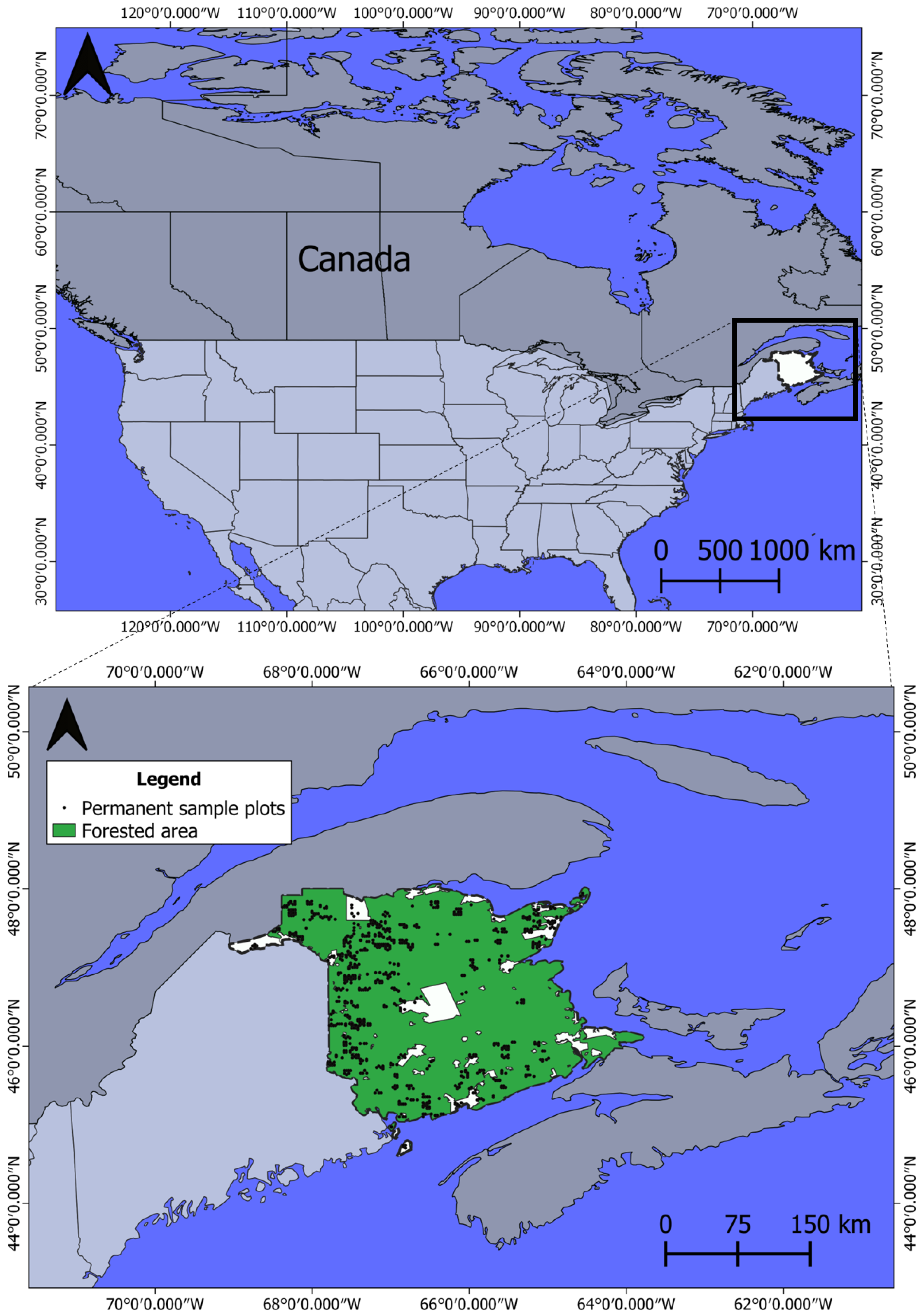
2.1. Study Area
2.2. Field Data
2.3. Satellite Images and Preprocessing
2.4. LiDAR Acquisition and Preprocessing
2.5. Dependent Variables
2.6. Environmental Variables
2.7. Statistical Analyses
3. Results
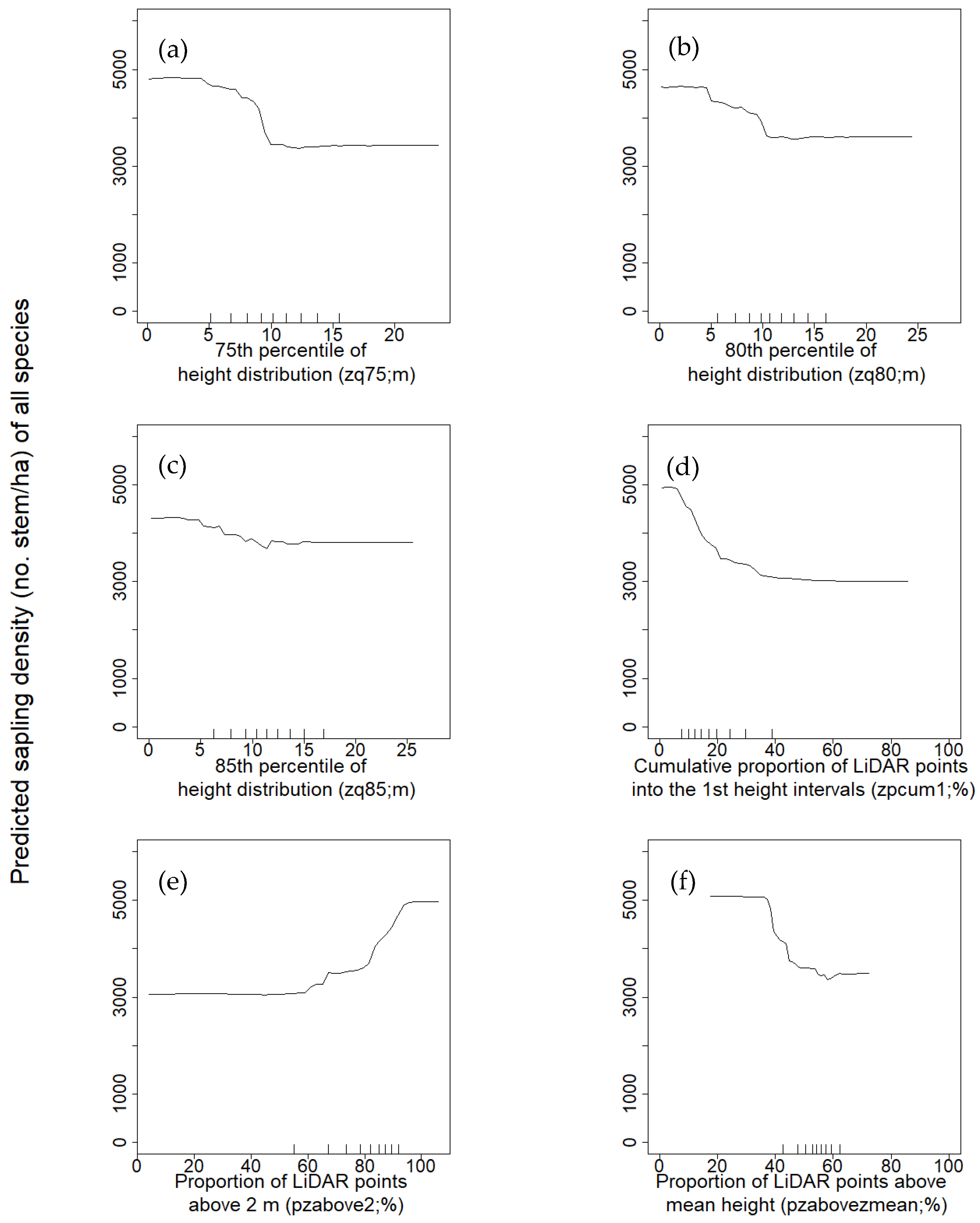
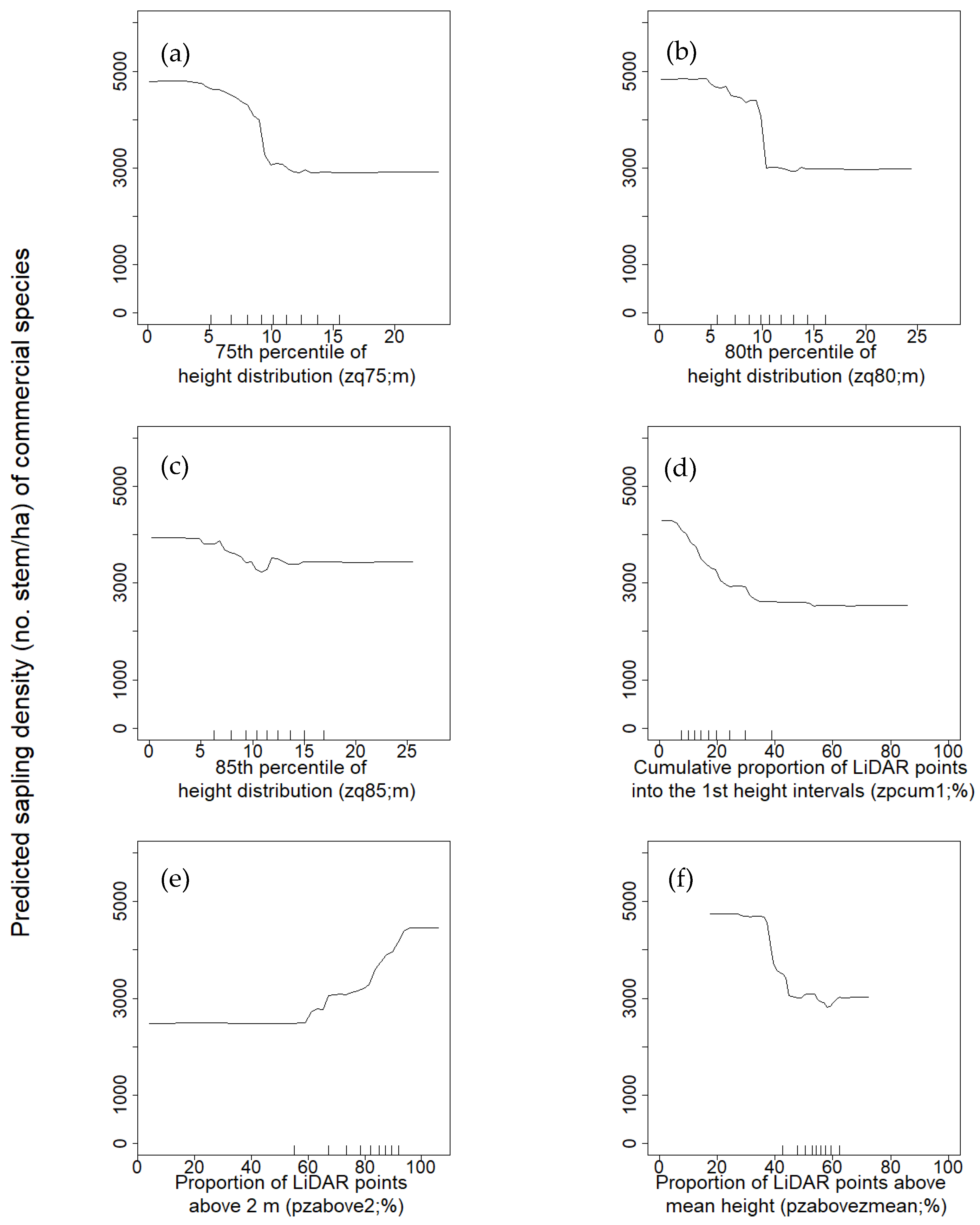
3.1. Variable Selection and Model Accuracy
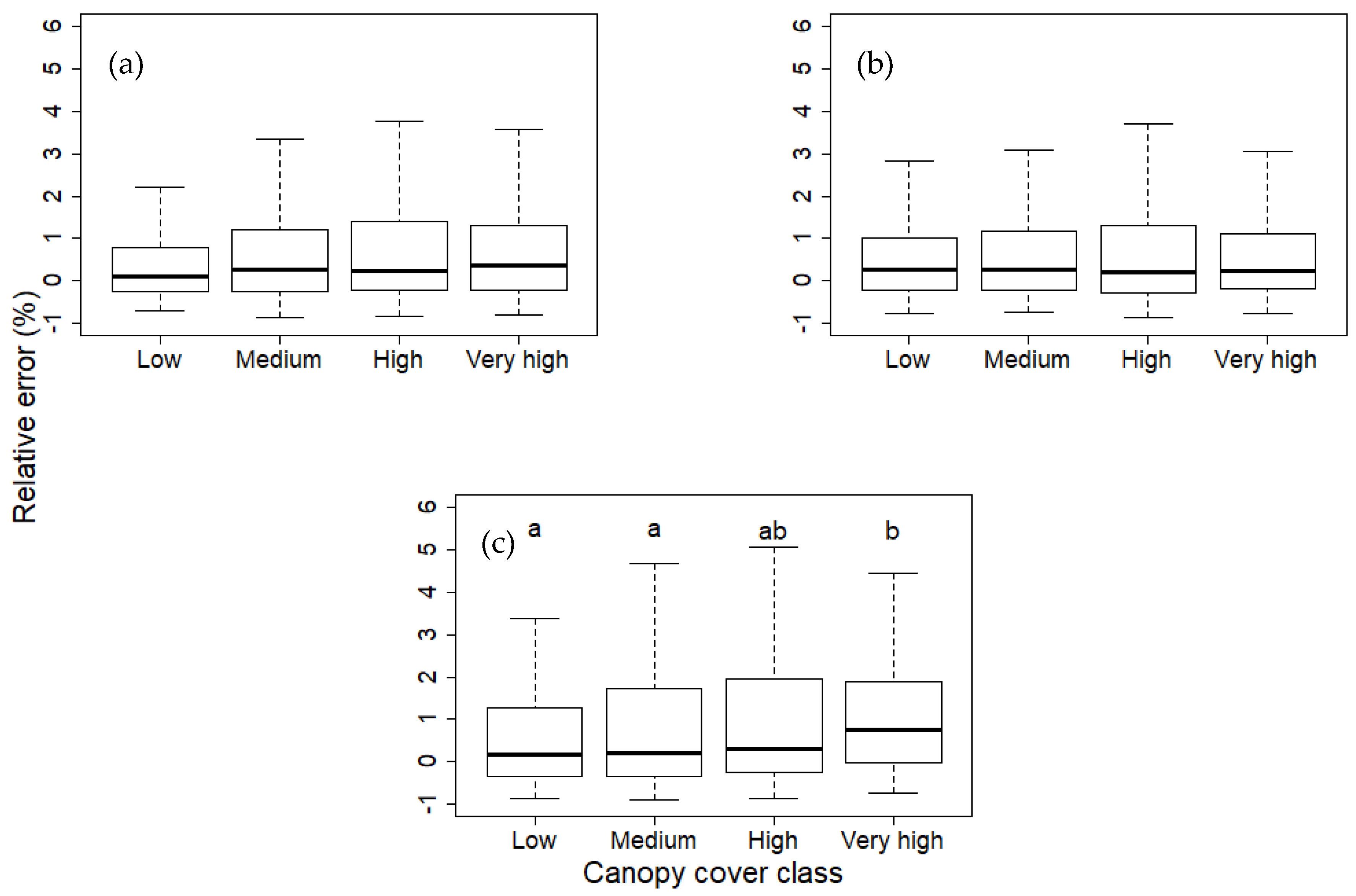
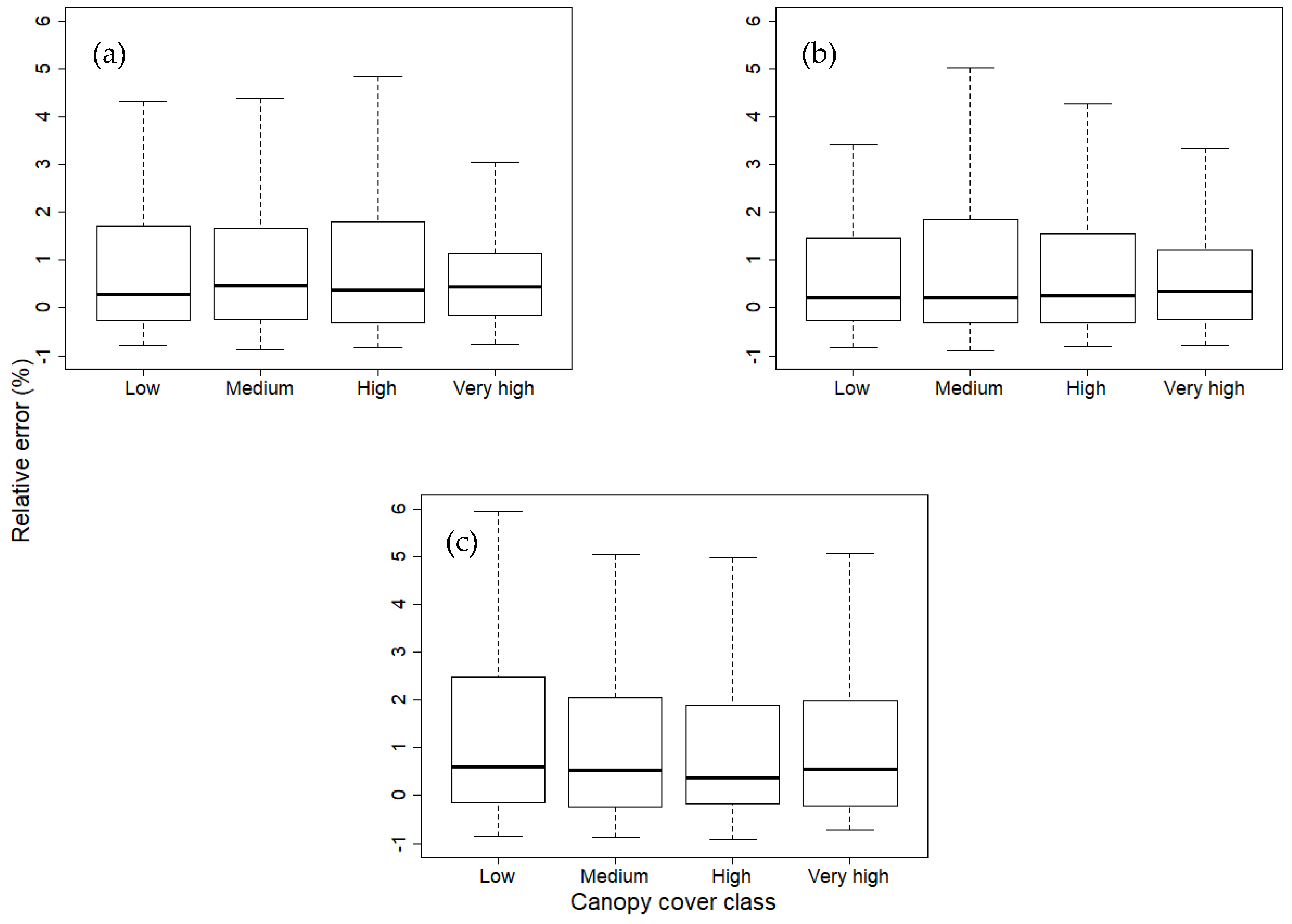
3.2. Effect of Canopy Cover
4. Discussion
4.1. Variable Selection and Model Accuracy
4.2. Effects of Canopy Cover
5. Conclusions
Author Contributions
Funding
Acknowledgments
Conflicts of Interest
References
- Ashton, M.S.; Kelty, M.J. The Practice of Silviculture: Applied Forest Ecology, 10th ed.; John Wiley & Sons, Inc.: New York, NY, USA, 2018. [Google Scholar]
- Andersen, H.E.; Reutebuch, S.E.; McGaughey, R.J. A rigorous assessment of tree height measurements obtained using airborne lidar and conventional field methods. Can. J. Remote Sens. 2006, 32, 355–366. [Google Scholar] [CrossRef]
- Aplin, P. Remote sensing: Ecology. Prog. Phys. Geogr. 2005, 29, 104–113. [Google Scholar] [CrossRef]
- Means, J.E.; Acker, S.A.; Harding, D.J.; Blair, J.B.; Lefsky, M.A.; Cohen, W.B.; Harmon, M.E.; McKee, W.A. Use of large-footprint scanning airborne lidar to estimate forest stand characteristics in the Western Cascades of Oregon. Remote Sens. Environ. 1999, 67, 298–308. [Google Scholar] [CrossRef]
- Bergen, K.M.; Dronova, I. Observing succession on aspen-dominated landscapes using a remote sensing-ecosystem approach. Landsc. Ecol. 2007, 22, 1395–1410. [Google Scholar] [CrossRef]
- Franklin, S.E. Remote Sensing for Sustainable Forest Management; CRC Press: Boca Raton, FL, USA, 2001. [Google Scholar]
- Ogaya, R.; Barbeta, A.; Başnou, C.; Peñuelas, J. Satellite data as indicators of tree biomass growth and forest dieback in a Mediterranean holm oak forest. Ann. For. Sci. 2015, 72, 135–144. [Google Scholar] [CrossRef]
- Steininger, M.K. Satellite estimation of tropical secondary forest above-ground biomass: Data from Brazil and Bolivia. Int. J. Remote Sens. 2000, 21, 1139–1157. [Google Scholar] [CrossRef]
- Jaiswal, R.K.; Mukherjee, S.; Raju, K.D.; Saxena, R. Forest fire risk zone mapping from satellite imagery and GIS. Int. J. Appl. Earth Obs. 2002, 4, 1–10. [Google Scholar] [CrossRef]
- Hansen, M.C.; Loveland, T.R. A review of large area monitoring of land cover change using Landsat data. Remote Sens. Environ. 2012, 122, 66–74. [Google Scholar] [CrossRef]
- Simard, M.; Pinto, N.; Fisher, J.B.; Baccini, A. Mapping forest canopy height globally with spaceborne lidar. J. Geophys. Res. Biogeosci. 2011, 116. [Google Scholar] [CrossRef]
- Popescu, S.C.; Wynne, R.H.; Nelson, R.F. Measuring individual tree crown diameter with lidar and assessing its influence on estimating forest volume and biomass. Can. J. Remote Sens. 2003, 29, 564–577. [Google Scholar] [CrossRef]
- Coops, N.C.; Hilker, T.; Wulder, M.A.; St-Onge, B.; Newnham, G.; Siggins, A.; Trofymow, J.T. Estimating canopy structure of Douglas-fir forest stands from discrete-return LiDAR. Trees 2007, 21, 295. [Google Scholar] [CrossRef]
- Maltamo, M.; Mustonen, K.; Hyyppä, J.; Pitkänen, J.; Yu, X. The accuracy of estimating individual tree variables with airborne laser scanning in a boreal nature reserve. Can. J. For. Res. 2004, 34, 1791–1801. [Google Scholar] [CrossRef]
- Falkowski, M.J.; Smith, A.M.; Gessler, P.E.; Hudak, A.T.; Vierling, L.A.; Evans, J.S. The influence of conifer forest canopy cover on the accuracy of two individual tree measurement algorithms using lidar data. Can. J. Remote Sens. 2008, 34, S338–S350. [Google Scholar] [CrossRef]
- Latifi, H.; Heurich, M.; Hartig, F.; Müller, J.; Krzystek, P.; Jehl, H.; Dech, S. Estimating over-and understorey canopy density of temperate mixed stands by airborne LiDAR data. Forestry 2015, 89, 69–81. [Google Scholar] [CrossRef]
- Campbell, M.J.; Dennison, P.E.; Hudak, A.T.; Parham, L.M.; Butler, B.W. Quantifying understory vegetation density using small-footprint airborne lidar. Remote Sens. Environ. 2018, 215, 330–342. [Google Scholar] [CrossRef]
- Wing, B.M.; Ritchie, M.W.; Boston, K.; Cohen, W.B.; Gitelman, A.; Olsen, M.J. Prediction of understory vegetation cover with airborne lidar in an interior ponderosa pine forest. Remote Sens. Environ. 2012, 124, 730–741. [Google Scholar] [CrossRef]
- Næsset, E. Assessing sensor effects and effects of leaf-off and leaf-on canopy conditions on biophysical stand properties derived from small-footprint airborne laser data. Remote Sens. Environ. 2005, 98, 356–370. [Google Scholar] [CrossRef]
- Morsdorf, F.; Mårell, A.; Koetz, B.; Cassagne, N.; Pimont, F.; Rigolot, E.; Allgöwer, B. Discrimination of vegetation strata in a multi-layered Mediterranean forest ecosystem using height and intensity information derived from airborne laser scanning. Remote Sens. Environ. 2010, 114, 1403–1415. [Google Scholar] [CrossRef]
- Moskal, L.M.; Price, J.P.; Jakubauskas, M.E.; Martinko, E.A. Comparison of hyperspectral AVIRIS and Landsat TM imagery for estimating burn site pine seedling regeneration densities in the Central Plateau of Yellowstone National Park. In Proceedings of the Third International Conference on Geospatial Information in Agriculture and Forestry, Denver, CO, USA, 5–7 November 2001. [Google Scholar]
- Martín-Alcón, S.; Coll, L.; De Cáceres, M.; Guitart, L.; Cabré, M.; Just, A.; González-Olabarría, J.R. Combining aerial LiDAR and multispectral imagery to assess postfire regeneration types in a Mediterranean forest. Can. J. For. Res. 2015, 45, 856–866. [Google Scholar] [CrossRef]
- McCombs, J.W.; Roberts, S.D.; Evans, D.L. Influence of fusing lidar and multispectral imagery on remotely sensed estimates of stand density and mean tree height in a managed loblolly pine plantation. For. Sci. 2003, 49, 457–466. [Google Scholar]
- Korpela, I.; Tuomola, T.; Tokola, T.; Dahlin, B. Appraisal of seedling-stand vegetation with airborne imagery and discrete-return LiDAR–an exploratory analysis. Silva Fenn. 2008, 42, 753–772. [Google Scholar] [CrossRef]
- Su, J.G.; Bork, E.W. Integrating LIDAR data and multispectral imagery for enhanced classification of rangeland vegetation: A meta analysis. Remote Sens. Environ. 2007, 111, 11–24. [Google Scholar]
- Martinuzzi, S.; Vierling, L.A.; Gould, W.A.; Falkowski, M.J.; Evans, J.S.; Hudak, A.T.; Vierling, K.T. Mapping snags and understory shrubs for a LiDAR-based assessment of wildlife habitat suitability. Remote Sens. Environ. 2009, 113, 2533–2546. [Google Scholar] [CrossRef]
- Tuanmu, M.N.; Viña, A.; Bearer, S.; Xu, W.; Ouyang, Z.; Zhang, H.; Liu, J. Mapping understory vegetation using phenological characteristics derived from remotely sensed data. Remote Sens. Environ. 2010, 114, 1833–1844. [Google Scholar] [CrossRef]
- Hall, R.J.; Peddle, D.R.; Klita, D.L. Mapping conifer understory within boreal mixedwoods from Landsat TM satellite imagery and forest inventory information. For. Chron. 2000, 76, 887–902. [Google Scholar] [CrossRef]
- Chastain, R.A., Jr.; Townsend, P.A. Use of Landsat ETM and topographic data to characterize evergreen understory communities in Appalachian deciduous forests. Photogramm. Eng. Remote Sens. 2007, 73, 563–575. [Google Scholar] [CrossRef]
- Wang, T.; Skidmore, A.K.; Toxopeus, A.G.; Liu, X. Understory bamboo discrimination using a winter image. Photogramm. Eng. Remote Sens. 2009, 75, 37–47. [Google Scholar] [CrossRef]
- Fiorella, M.; Ripple, W.J. Determining successional stage of temperate coniferous forests with Landsat satellite data. Photogramm. Eng. Remote Sens. 1995, 59, 239–246. [Google Scholar]
- Potter, C.; Li, S.; Huang, S.; Crabtree, R.L. Analysis of sapling density regeneration in Yellowstone National Park with hyperspectral remote sensing data. Remote Sens. Environ. 2012, 121, 61–68. [Google Scholar] [CrossRef]
- Pouliot, D.A.; King, D.J.; Pitt, D.G. Development and evaluation of an automated tree detection delineation algorithm for monitoring regenerating coniferous forests. Can. J. For. Res. 2005, 35, 2332–2345. [Google Scholar] [CrossRef]
- Maltamo, M.; Packalén, P.; Yu, X.; Eerikäinen, K.; Hyyppä, J.; Pitkänen, J. Identifying and quantifying structural characteristics of heterogeneous boreal forests using laser scanner data. For. Ecol. Manag. 2005, 216, 41–50. [Google Scholar] [CrossRef]
- Hill, R.A.; Broughton, R.K. Mapping the understorey of deciduous woodland from leaf-on and leaf-off airborne LiDAR data: A case study in lowland Britain. ISPRS J. Photogramm. Remote Sens. 2009, 64, 223–233. [Google Scholar] [CrossRef]
- Sumnall, M.J.; Hill, R.A.; Hinsley, S.A. Comparison of small-footprint discrete return and full waveform airborne LiDAR data for estimating multiple forest variables. Remote Sens. Environ. 2016, 173, 214–223. [Google Scholar] [CrossRef]
- Korpela, I.; Hovi, A.; Morsdorf, F. Understory trees in airborne LiDAR data—Selective mapping due to transmission losses and echo-triggering mechanisms. Remote Sens. Environ. 2012, 119, 92–104. [Google Scholar] [CrossRef]
- Næsset, E.; Bjerknes, K.O. Estimating tree heights and number of stems in young forest stands using airborne laser scanner data. Remote Sens. Environ. 2001, 78, 328–340. [Google Scholar] [CrossRef]
- Wulder, M.A.; Franklin, S.E. Remote Sensing of Forest Environments; Springer: Boston, MA, USA, 2003; pp. 3–12. [Google Scholar]
- Pesonen, A.; Maltamo, M.; Eerikäinen, K.; Packalèn, P. Airborne laser scanning-based prediction of coarse woody debris volumes in a conservation area. For. Ecol. Manag. 2008, 255, 3288–3296. [Google Scholar] [CrossRef]
- Hudak, A.T.; Crookston, N.L.; Evans, J.S.; Falkowski, M.J.; Smith, A.M.; Gessler, P.E.; Morgan, P. Regression modeling and mapping of coniferous forest basal area and tree density from discrete-return lidar and multispectral satellite data. Can. J. Remote Sens. 2006, 32, 126–138. [Google Scholar] [CrossRef]
- Villikka, M.; Packalén, P.; Maltamo, M. The suitability of leaf-off airborne laser scanning data in an area-based forest inventory of coniferous and deciduous trees. Silva Fenn. 2012, 46, 99–110. [Google Scholar] [CrossRef]
- Imangholiloo, M.; Saarinen, N.; Markelin, L.; Rosnell, T.; Näsi, R.; Hakala, T.; Honkavaara, E.; Holopainen, M.; Hyyppä, J.; Vastaranta, M. Characterizing seedling stands using leaf-off and leaf-on photogrammetric point clouds and hyperspectral imagery acquired from unmanned aerial vehicle. Forests 2019, 10, 415. [Google Scholar] [CrossRef]
- Zald, H.S.; Ohmann, J.L.; Roberts, H.M.; Gregory, M.J.; Henderson, E.B.; McGaughey, R.J.; Braaten, J. Influence of lidar, Landsat imagery, disturbance history, plot location accuracy, and plot size on accuracy of imputation maps of forest composition and structure. Remote Sens. Environ. 2014, 143, 26–38. [Google Scholar] [CrossRef]
- Leckie, D.; Gougeon, F.; Hill, D.; Quinn, R.; Armstrong, L.; Shreenan, R. Combined high-density lidar and multispectral imagery for individual tree crown analysis. Can. J. Remote Sens. 2003, 29, 633–649. [Google Scholar] [CrossRef]
- Coops, N.C.; Wulder, M.A.; Culvenor, D.S.; St-Onge, B. Comparison of forest attributes extracted from fine spatial resolution multispectral and lidar data. Can. J. Remote Sens. 2004, 30, 855–866. [Google Scholar] [CrossRef]
- Hyde, P.; Dubayah, R.; Walker, W.; Blair, J.B.; Hofton, M.; Hunsaker, C. Mapping forest structure for wildlife habitat analysis using multi-sensor (LiDAR, SAR/InSAR, ETM+, Quickbird) synergy. Remote Sens. Environ. 2006, 102, 63–73. [Google Scholar] [CrossRef]
- Miller, R.F. Environmental History of the Atlantic Maritime Ecozone. In Assessment of Species Diversity in the Atlantic Maritime Ecozone; NRC Research Press: Ottawa, ON, Canada, 2010; pp. 13–303. [Google Scholar] [CrossRef]
- Zelazny, V.F.; Martin, G.L.; Toner, M.; Gorman, M.; Colpitts, M.; Veen, H.; Godin, B.; McInnis, B.; Steeves, C.; Wuest, L.; et al. Our Landscape Heritage: The Story of Ecological Land Classification in New Brunswick; New Brunswick Department of Natural Resources: Fredericton, NB, Canada, 2007.
- Mosseler, A.; Lynds, J.A.; Major, J.E. Old-growth forests of the Acadian Forest Region. Environ. Rev. 2003, 11, S47–S77. [Google Scholar] [CrossRef]
- Fraver, S.; White, A.S.; Seymour, R.S. Natural disturbance in an old-growth landscape of northern Maine, USA. J. Ecol. 2009, 97, 289–298. [Google Scholar] [CrossRef]
- Rowe, J.S. Forest Regions of Canada; Canadian Forestry Service: Ottawa, ON, Canada, 1972.
- Loo, J.; Ives, N. The Acadian forest: Historical condition and human impacts. For. Chron. 2003, 79, 462–474. [Google Scholar] [CrossRef]
- NBDNRED. Enhanced Forest Inventory Data Collection Protocols; New Brunswick Department of Natural Resources: Fredericton, NB, Canada, 2015.
- Petriţan, A.M.; von Lüpke, B.; Petriţan, I.C. Influence of light availability on growth, leaf morphology and plant architecture of beech (Fagus sylvatica L.), maple (Acer pseudoplatanus L.) and ash (Fraxinus excelsior L.) saplings. Eur. J. For. Res. 2009, 128, 61–74. [Google Scholar] [CrossRef]
- Claveau, Y.; Messier, C.; Comeau, P.G.; Coates, K.D. Growth and crown morphological responses of boreal conifer seedlings and saplings with contrasting shade tolerance to a gradient of light and height. Can. J. For. Res. 2002, 32, 458–468. [Google Scholar] [CrossRef]
- Janse-ten Klooster, S.H.; Thomas, E.J.P.; Sterck, F.J. Explaining interspecific differences in sapling growth and shade tolerance in temperate forests. J. Ecol. 2007, 95, 1250–1260. [Google Scholar] [CrossRef]
- Zuhlke, M.; Fomferra, N.; Brockmann, C.; Peters, M.; Veci, L.; Malik, J.; Regner, P. SNAP (sentinel application platform) and the ESA sentinel 3 toolbox. In Proceedings of the Sentinel-3 for Science Workshop, Venice, Italy, 2–5 June 2015. [Google Scholar]
- LAStools-Efficient Tools for LiDAR Processing. Version 141017. 2014. Available online: http://lastools.org (accessed on 7 May 2019).
- Roussel, J.-R.; Auty, D. lidR: Airborne LiDAR Data Manipulation and Visualization for Forestry Applications. 2017. Available online: https://cran.r-project.org/web/packages/lidR/index.html2017 (accessed on 12 June 2019).
- R Development Core Team. R Development Core Team R: A Language and Environment for Statistical Computing; R Foundation for Statistical Computing: Vienna, Austria, 2018. [Google Scholar]
- Woods, M.; Lim, K.; Treitz, P. Predicting forest stand variables from LIDAR data in the Great Lakes St. Lawrence Forest of Ontario. For. Chron. 2008, 84, 827–839. [Google Scholar] [CrossRef]
- Hennigar, C.; Weiskittel, A.; Allen, H.L.; MacLean, D.A. Development and evaluation of a biomass increment based index for site productivity. Can. J. For. Res. 2016, 47, 400–410. [Google Scholar] [CrossRef]
- Liaw, A.; Weiner, M. Classification and regression by randomForest. R News 2002, 2, 18–22. [Google Scholar]
- Genuer, R.; Poggi, J.M.; Tuleau-Malot, C. VSURF: An R package for variable selection using random forests. R J. 2015, 7, 19–33. [Google Scholar] [CrossRef]
- Strobl, C.; Boulesteix, A.L.; Zeileis, A.; Hothorn, T. Bias in random forest variable importance measures: Illustrations, sources and a solution. BMC Bioinform. 2007, 8, 25. [Google Scholar] [CrossRef] [PubMed]
- Pearse, G.D.; Dash, J.P.; Persson, H.J.; Watt, M.S. Comparison of high-density LiDAR and satellite photogrammetry for forest inventory. ISPRS J. Photogramm. Remote Sens. 2018, 142, 257–267. [Google Scholar] [CrossRef]
- Donoghue, D.N.M.; Watt, P.J. Using LiDAR to compare forest height estimates from IKONOS and Landsat ETM+ data in Sitka spruce plantation forests. Int. J. Remote Sens. 2006, 27, 2161–2175. [Google Scholar] [CrossRef]
- Korhonen, L.; Pippuri, I.; Packalén, P.; Heikkinen, V.; Maltamo, M.; Heikkilä, J. Detection of the need for seedling stand tending using high-resolution remote sensing data. Silva Fenn. 2013, 47, 1–20. [Google Scholar] [CrossRef]
- Key, T.; Warner, T.A.; McGraw, J.B.; Fajvan, M.A. A comparison of multispectral and multitemporal information in high spatial resolution imagery for classification of individual tree species in a temperate hardwood forest. Remote Sens. Environ. 2001, 75, 100–112. [Google Scholar] [CrossRef]


| Abbreviation | Description |
|---|---|
| zmax | Maximum height |
| zmean | Mean height |
| zsd | Standard deviation of height distribution |
| zskew | Skewness of height distribution |
| zkurt | Kurtosis of height distribution |
| zentropy | Entropy of height distribution |
| pzabovezmean | Percentage of returns above zmean |
| pzabove2 | Percentage of returns above 2 m |
| zqx | Xth percentile of height distribution |
| zpcumx | Cumulative percentage of return in the xth layer according to Wood et al. [62] |
| itot | Sum of intensities for each return |
| imax | Maximum intensity |
| imean | Mean intensity |
| isd | Standard deviation of intensity |
| iskew | Standard deviation of intensity |
| ikurt | Skewness of intensity distribution |
| ipground | Percentage of intensity returned by points classified as ground |
| ipcumzqx | Percentage of intensity returned below the xth percentile of height |
| pxth | Percentage xth returns |
| pground | Percentage of returns classified as ground |
| Species Grouping | Species | |
|---|---|---|
| Commercial species | Hardwoods | American beech (Fagus grandifolia) |
| American elm (Ulmus americanus) | ||
| Balsam poplar (Populus balsamifera) | ||
| American basswood (Tilia americana) | ||
| Black ash (Fraxinus nigra) | ||
| Black cherry (Prunus serotina) | ||
| Butternut (Juglans cinerea) | ||
| Green ash (Fraxinus pennsylvanica) | ||
| Grey birch (Betula populifolia) | ||
| Ironwood (Ostrya virginiana) | ||
| Large-tooth aspen (Populus grandidentata) | ||
| Oaks (Quercus spp.) | ||
| Red maple (Acer rubrum) | ||
| Silver maple (Acer saccharinum) | ||
| Sugar maple (Acer saccharum) | ||
| Trembling aspen (Populus tremuloides) | ||
| White ash (Fraxinus americanus) | ||
| White birch (Betula papyrifera) | ||
| Yellow birch (Betula alleghaniensis) | ||
| Softwoods | Balsam fir (Abies balsamea) | |
| Black spruce (Picea mariana) | ||
| Eastern hemlock (Tsuga canadensis) | ||
| Eastern White Cedar (Thuja occidentalis) | ||
| Jack pine (Pinus banksiana) | ||
| Norway spruce (Picea abies) | ||
| Red pine (Pinus resinosa) | ||
| Red spruce (Picea rubens) | ||
| Tamarack (Larix laricina) | ||
| White pine (Pinus stobus) | ||
| White spruce (Picea glauca) | ||
| Non-Commercial | Hardwoods | American mountain ash (Sorbus americana) |
| Apple (Malus spp.) | ||
| Choke cherry (Prunus virginiana) | ||
| Hawthorns (Crataegus spp.) | ||
| Mountain maple (Acer spicatum) | ||
| Pin cherry (Prunus pensylvanica) | ||
| Serviceberry (Amelanchier spp.) | ||
| Speckled alder (Alnus rugosa) | ||
| Striped maple (Acer pensylvanicum) | ||
| Willows (Salix spp.) | ||
| Candidate Models | Variables Selected | RMSE (no. stem/ha; 95% C.I.) | Relative RMSE (%; 95% C.I.) | Pseudo R-Squared (95% C.I.) |
|---|---|---|---|---|
| Sapling density of all species | ||||
| LiDAR + Spectral + Environmental | zq80 + zq75 + zq85 + zq60 + zq70 + zq55 + zq50 + zq40 + pzabove2 + zpcum1 + zq30 + zskew + pzabovemean + canopy cover + p1th + basal area | 2828 (2814–2841) | 84 (84–84) | 0.33 (0.32–0.34) |
| LiDAR + Environmental | zq80 + zq85 + zq75 + zq70 + zq60 + zpcum1 + zq95 + zq55 + pzabove2 + zq30 + zq50 + pzabovezmean + basal area | 2836 (2827–2844) | 84 (84–84) | 0.33 (0.32–0.33) |
| Spectral + Environmental | Basal area | 3320 (3317–3323) | 98 (98–98) | 0.08 (0.08–0.08) |
| Sapling density of commercial species | ||||
| LiDAR + Spectral + Environmental | zq80 + zpcum1 + zq85 + zq75 + zq90 + pzabove2 + zq30 + zq95 + zq65 + zq60 + zpcum2 + zmean + zq50 +pzabovezmean | 2784 (2776–2792) | 100 (100–100) | 0.23 (0.23–0.24) |
| LiDAR + Environmental | zq80 + zq75 + zq85 + zpcum1 + zq90 + pzabove2 + zq70 + zq30 + zq60 + zpcum2 + zq50 + pzabovezmean | 2779 (2773–2785) | 100 (100–100) | 0.24 (0.23–0.24) |
| Spectral + Environmental | Canopy cover + basal area + proportion of hardwood + NDVI + Red + Blue + Green + Ecodistrict | 3165 (3156–3174) | 114 (113–114) | 0.01 (0.002–0.01) |
© 2020 by the authors. Licensee MDPI, Basel, Switzerland. This article is an open access article distributed under the terms and conditions of the Creative Commons Attribution (CC BY) license (http://creativecommons.org/licenses/by/4.0/).
Share and Cite
Landry, S.; St-Laurent, M.-H.; Pelletier, G.; Villard, M.-A. The Best of Both Worlds? Integrating Sentinel-2 Images and airborne LiDAR to Characterize Forest Regeneration. Remote Sens. 2020, 12, 2440. https://doi.org/10.3390/rs12152440
Landry S, St-Laurent M-H, Pelletier G, Villard M-A. The Best of Both Worlds? Integrating Sentinel-2 Images and airborne LiDAR to Characterize Forest Regeneration. Remote Sensing. 2020; 12(15):2440. https://doi.org/10.3390/rs12152440
Chicago/Turabian StyleLandry, Stéphanie, Martin-Hugues St-Laurent, Gaetan Pelletier, and Marc-André Villard. 2020. "The Best of Both Worlds? Integrating Sentinel-2 Images and airborne LiDAR to Characterize Forest Regeneration" Remote Sensing 12, no. 15: 2440. https://doi.org/10.3390/rs12152440
APA StyleLandry, S., St-Laurent, M.-H., Pelletier, G., & Villard, M.-A. (2020). The Best of Both Worlds? Integrating Sentinel-2 Images and airborne LiDAR to Characterize Forest Regeneration. Remote Sensing, 12(15), 2440. https://doi.org/10.3390/rs12152440