GIS-based Landform Classification of Eneolithic Archaeological Sites in the Plateau-plain Transition Zone (NE Romania): Habitation Practices vs. Flood Hazard Perception


Abstract
:
1. Introduction
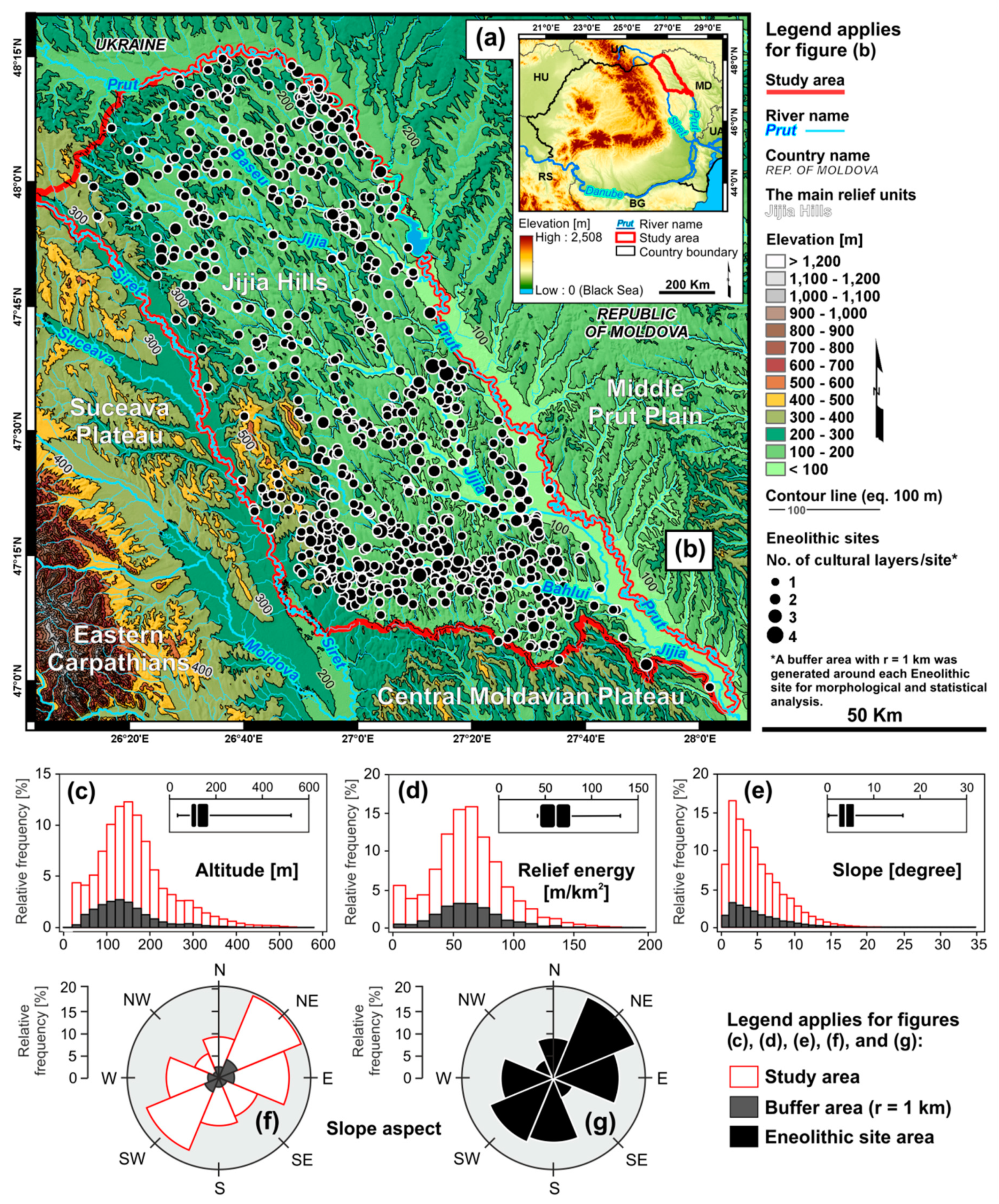
Regional Setting
2. Data and Methods
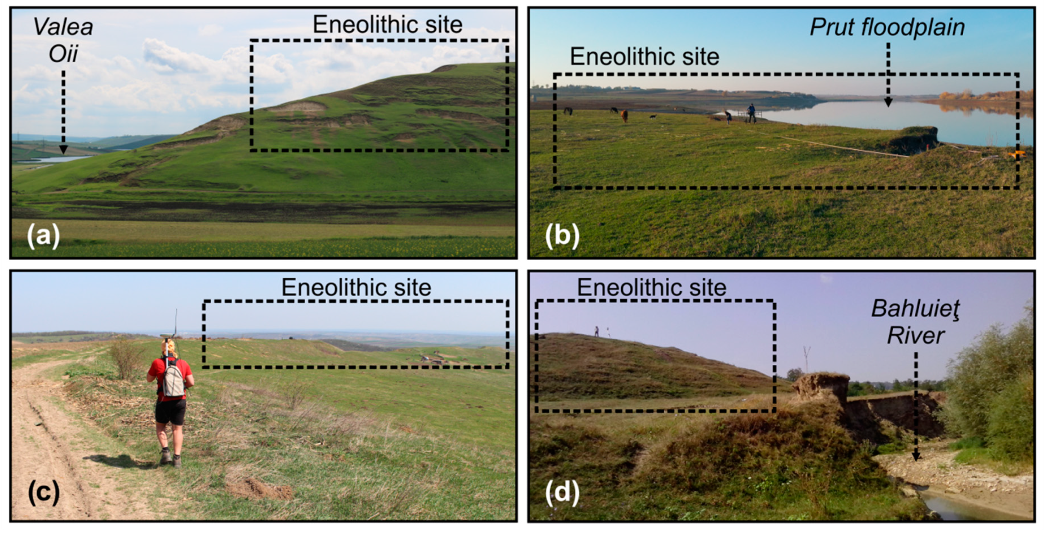
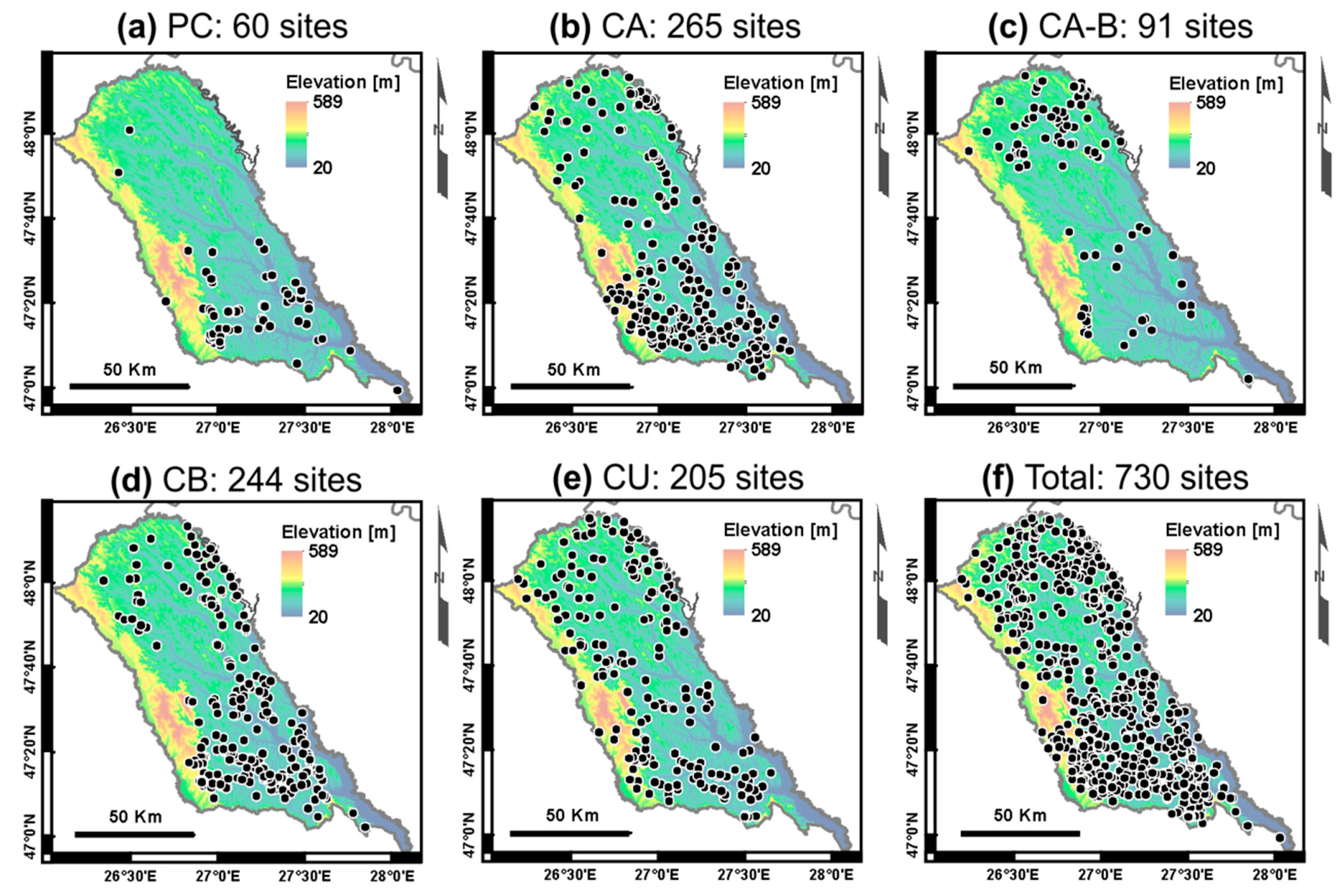
2.1. Inventory of Archaeological Sites
2.2. Elevation Data
2.3. Flood Hazard Data
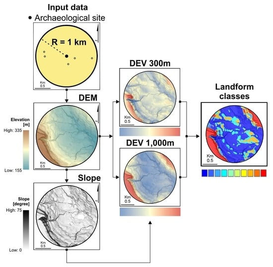
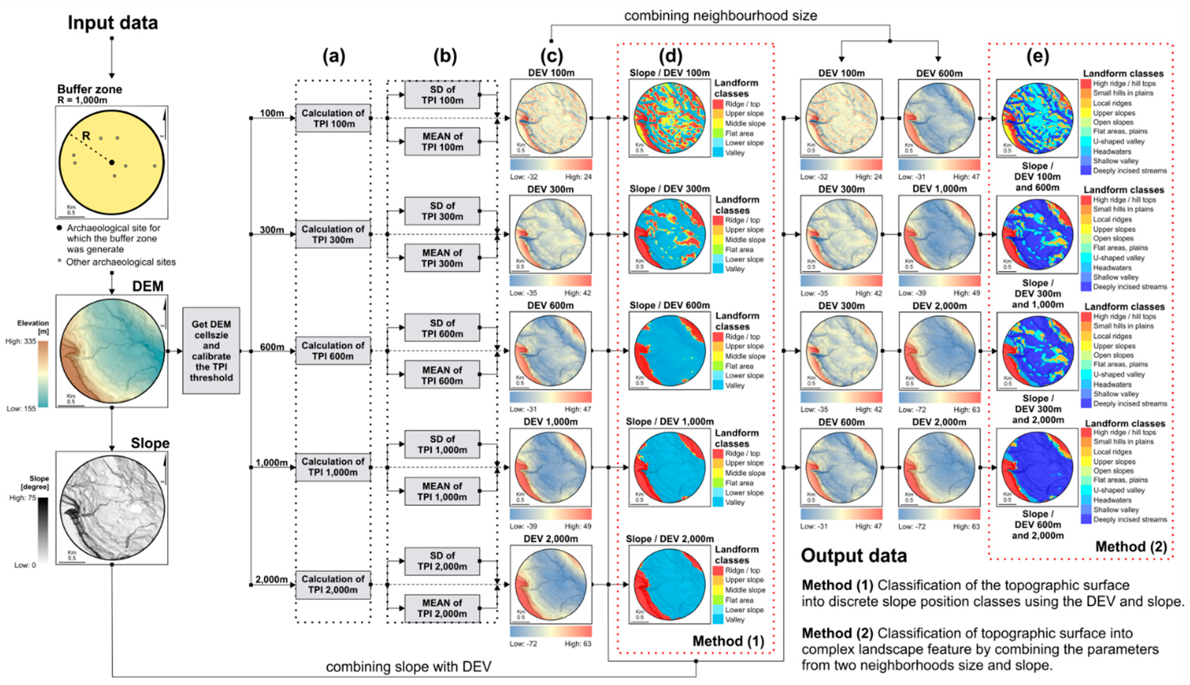
2.4. Delineation of Landform Units
2.4.1. TPI and DEV
2.4.2. Landform Classification
3. GIS-Based Landform Classification Results
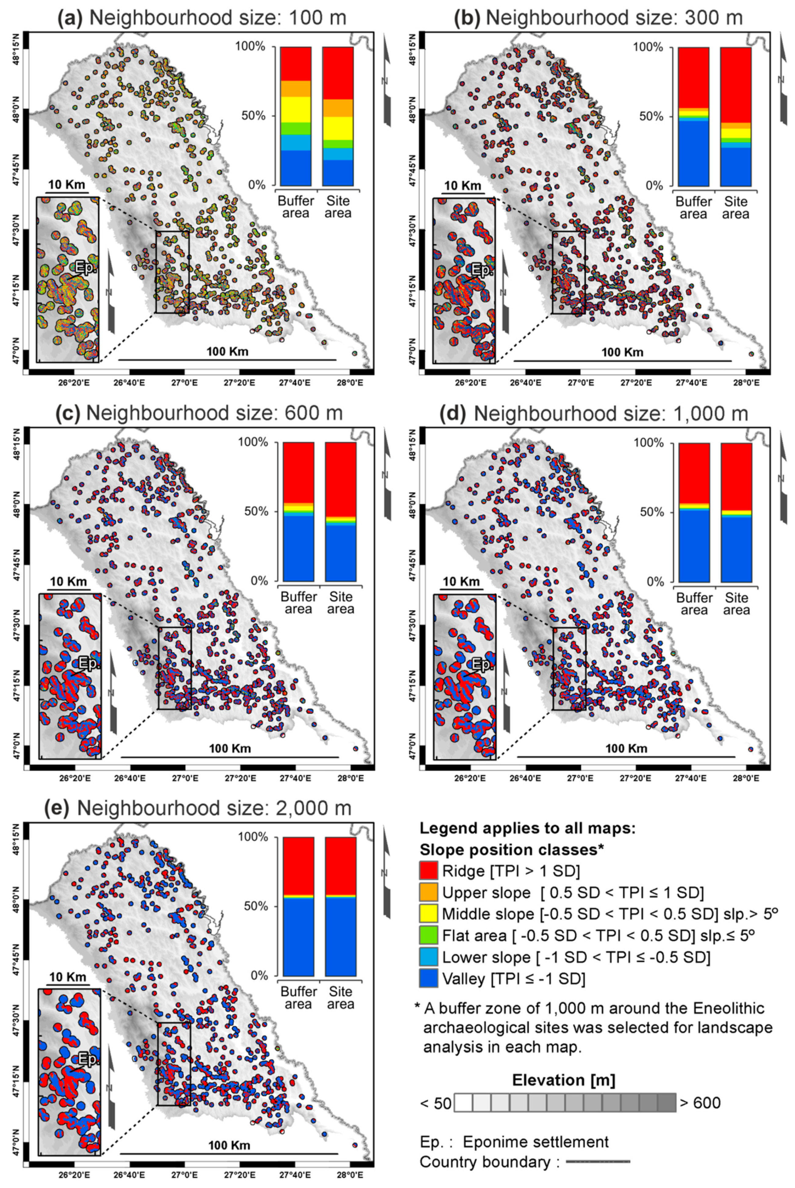
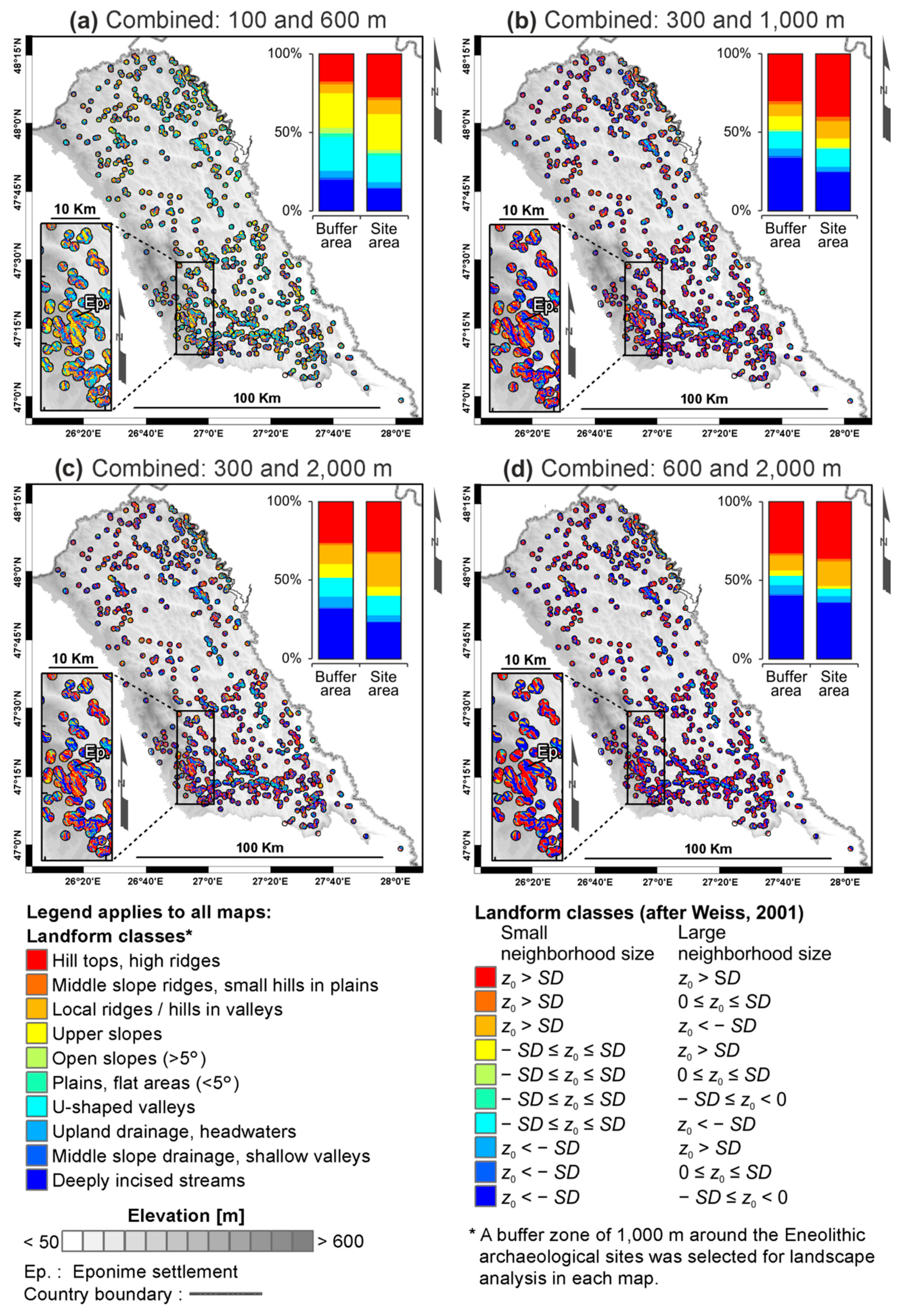
3.1. Validation of Landform Classification Accuracy for Various Neighbourhood Sizes
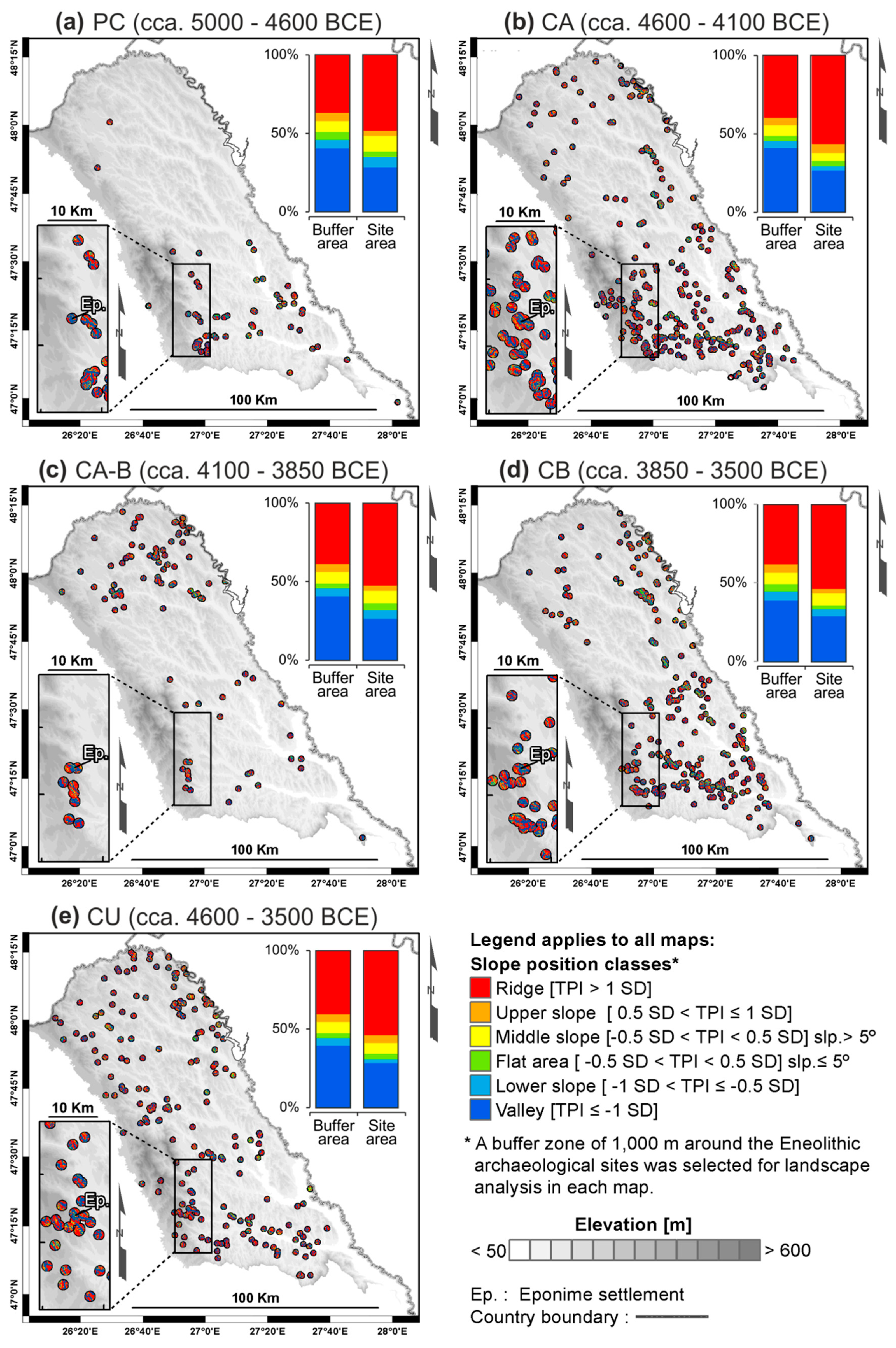
3.2. Classification of Archaeological Site Placement Based on Slope Position
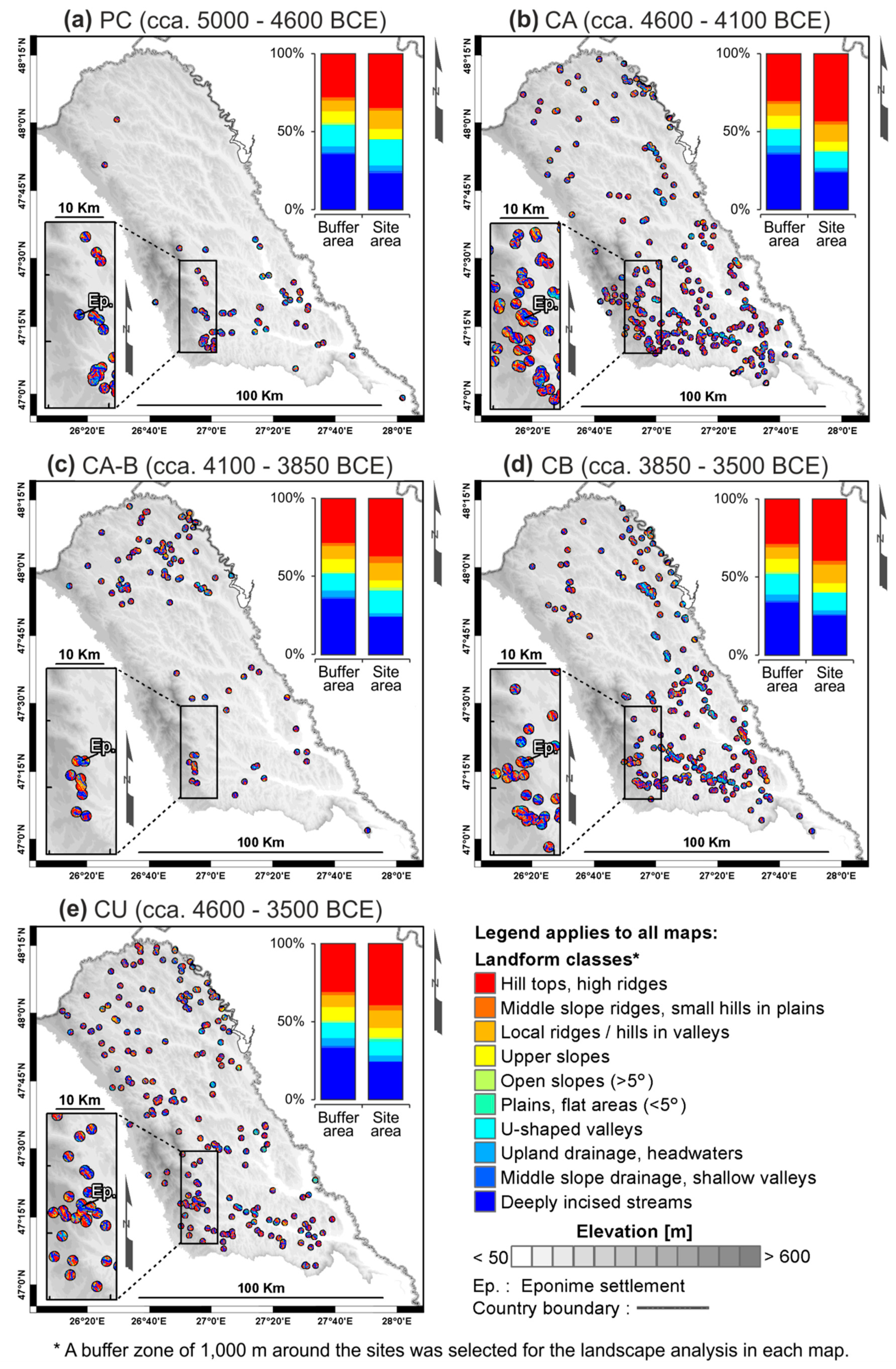
3.3. Classification of Archaeological Site Placement Based on Landform Units
4. Discussion
4.1. Habitation Practices During the Eneolithic Period
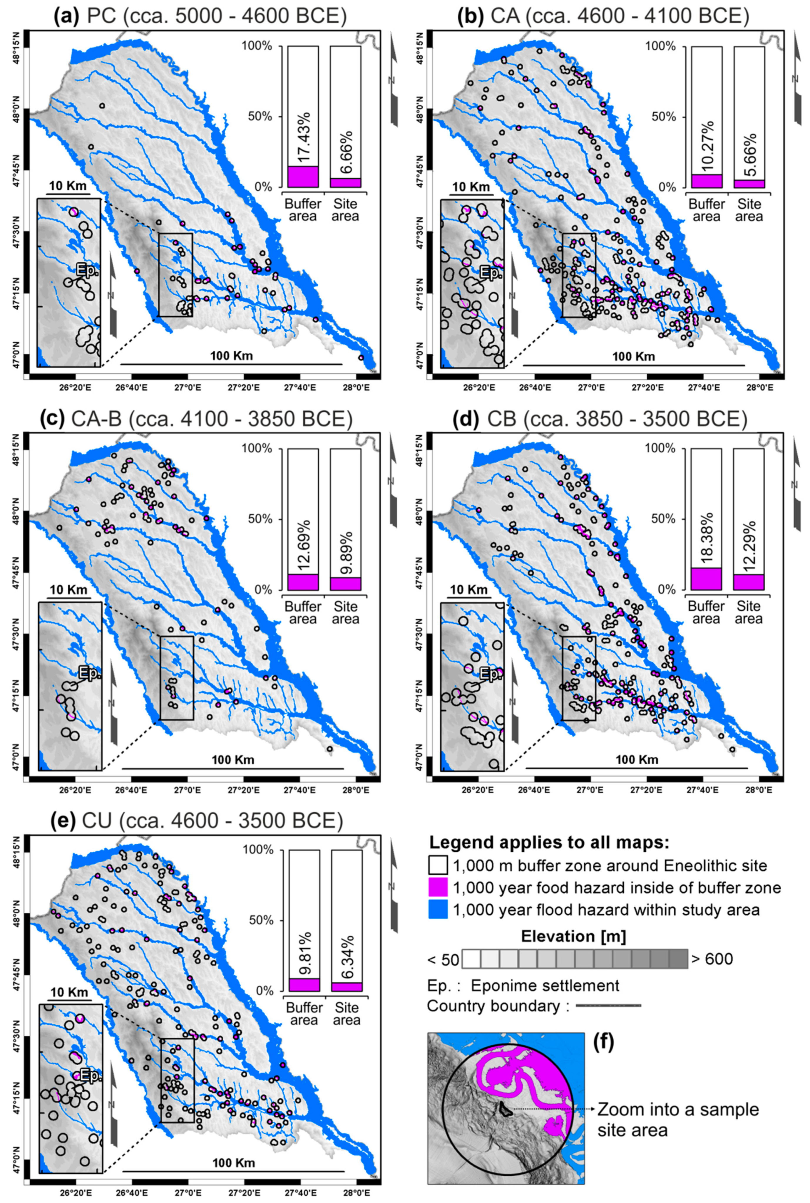
4.2. Flood Hazard Perception During the Eneolithic Period
5. Conclusions
- According to slope position classification based on DEV 300 m, over 65% of settlements were placed on the convex landforms (e.g., ridge, summit, hill top), <5% of total settlements on flat areas with a slope ≤ 5°, and 30% of settlements were placed on concave features (e.g., valleys).
- According to the TPI-landform classification by combining two neighbourhood sizes, in this study DEV 300 and DEV 1000, 59.5% of sites are located on positive landforms (e.g., hill tops, high ridges, small hills in plains, local ridges/hills in valley), 1.7 % sites are on the flat areas or on the gentle slope surfaces (< 5°), and 38.8% sites overlap on the negative landforms (e.g., U-shaped valleys, headwaters, shallow valley, deeply incised streams).
- According to flood hazard pattern generated for an extent with 0.1% insurance (1000 years), 8.2% of sites are located in vulnerable areas which indicate a high flood hazard perception during the Eneolithic period.
- The high-density settlements built on specific landforms (e.g., ridge, top of cuestas) indicate a habitation practice during the Eneolithic based on local topography and highlight a specific eco-cultural niche for the prehistoric communities in the plateau-plain transition zone of NE Romania.
Author Contributions
Funding
Acknowledgments
Conflicts of Interest
Abbreviations
| GIS | Geographic Information System |
| GPS | Global Positioning System |
| TPI | Topographic Position Index |
| SD | Standard Deviation |
| DEV | SD of TPI |
| LiDAR | Light Detection and Ranging |
| DEM | Digital Elevation Model |
| IDW | Inverse Distance Weighting |
| HEC-RAS | Hydrologic Engineering Centers—River Analysis System |
| R | Radius |
| Average elevation pixels for various candidate radii | |
| z0 | Central pixel elevation for various candidate radii |
| PC | Precucuteni cultural phase |
| CA | Cucuteni A cultural phase |
| CA–B | Cucuteni A–B cultural phase |
| CB | Cucuteni B cultural phase |
| CU | Cucuteni (unknown cultural phase) |
| BCE | Before Common Era |
References
- Blaszczynski, J.S. Landform characterization with geographic information systems. Photogramm. Eng. Rem. Sens. 1997, 63, 183–191. [Google Scholar]
- Pike, R.J. A Bibliography of Terrain Modeling (Geomorphometry), the Quantitative Representation of Topography—Supplement 4.0. US Geological Survey, 2002; pp. 1–158. Available online: https://pubs.usgs.gov/of/2002/0465/pdf/of02-465.pdf (accessed on 30 March 2019).
- Weiss, A.D. Topographic Position and Landforms Analysis. In Proceedings of the ESRI User Conference, San Diego, CA, USA, 9–13 July 2001; pp. 227–245. Available online: http://www.jennessent.com/downloads/TPI-poster-TNC_18x22.pdf (accessed on 28 January 2019).
- Argyriou, A.V.; Teeuw, R.M.; Sarris, A. GIS-based landform classification of Bronze Age archaeological sites on Crete Island. PLoS ONE 2017, 12, e0170727. [Google Scholar] [CrossRef] [PubMed]
- Deumlich, D.; Schmidt, R.; Sommer, M. A multiscale soil-landform relationship in the glacial-drift area based on digital terrain analysis and soil attributes. J. Plant. Nutr. Soil Sci. 2010, 173, 843–851. [Google Scholar] [CrossRef]
- Illés, G.; Kovács, G.; Heil, B. Comparing and evaluating digital soil mapping methods in a Hungarian forest reserve. Can. J. Soil Sci. 2011, 91, 615–626. [Google Scholar] [CrossRef]
- Mora-Vallejo, A.; Claessens, L.; Stoorvogel, J.; Heuvelink, G.B.M. Small scale digital soil mapping in southeastern Kenya. Catena 2008, 76, 44–53. [Google Scholar] [CrossRef]
- Pracilio, G.; Smettem, K.; Bennett, D.; Harper, R.; Adams, M. Site assessment of a woody crop where a shallow hardpan soil layer constrained plant growth. Plant. Soil. 2006, 288, 113–125. [Google Scholar] [CrossRef]
- Dębniak, K.; Mège, D.; Gurgurewicz, J. Geomorphology of Ius Chasma, Valles Marineris, Mars. J. Maps 2017, 13, 260–269. [Google Scholar] [CrossRef]
- Liu, M.; Hu, Y.; Chang, Y.; He, X.; Zhang, W. Land use and land cover change analysis and prediction in the upper reaches of the Minjiang River, China. Environ. Manag. 2009, 43, 899–907. [Google Scholar] [CrossRef] [PubMed]
- McGarigal, K.; Tagil, S.; Cushman, S. Surface metrics: An alternative to patch metrics for the quantification of landscape structure. Landsc. Ecol. 2009, 24, 433–450. [Google Scholar] [CrossRef]
- Tagil, S.; Jenness, J. GIS-based automated landform classification and topographic, landcover and geologic attributes of landforms around the Yazoren Polje, Turkey. J. Appl. Sci. 2008, 8, 910–921. [Google Scholar] [CrossRef]
- Wilson, M.F.J.; O’Connell, B.; Brown, C.; Guinan, J.C.; Grehan, A.J. Multiscale terrain analysis of multibeam bathymetry data for habitat mapping on the continental slope. Mar. Geod. 2007, 30, 3–35. [Google Scholar] [CrossRef]
- Wright, D.J.; Heyman, W.D. Introduction to the special issue: Marine and coastal GIS for geomorphology, habitat mapping, and marine reserves. Mar. Geod. 2008, 31, 223–230. [Google Scholar] [CrossRef]
- Zieger, S.; Stieglitz, T.; Kininmonth, S. Mapping reef features from multibeam sonar data using multiscale morphometric analysis. Mar. Geol. 2009, 264, 209–217. [Google Scholar] [CrossRef]
- Francés, A.P.; Lubczynski, M.W. Topsoil thickness prediction at the catchment scale by integration of invasive sampling, surface geophysics, remote sensing and statistical modeling. J. Hydrol. 2011, 405, 31–47. [Google Scholar] [CrossRef]
- Lesschen, J.P.; Kok, K.; Verburg, P.H.; Cammeraat, L.H. Identification of vulnerable areas for gully erosion under different scenarios of land abandonment in southeast Spain. Catena 2007, 71, 110–121. [Google Scholar] [CrossRef]
- Liu, H.; Bu, R.; Liu, J.; Leng, W.; Hu, Y.; Yang, L.; Liu, H. Predicting the wetland distributions under climate warming in the Great Xing’an Mountains, northeastern China. Ecol. Res. 2011, 26, 605–613. [Google Scholar] [CrossRef]
- Bunn, A.; Hughes, M.; Salzer, M. Topographically modified tree-ring chronologies as a potential means to improve paleoclimate inference. Clim. Chang. 2011, 105, 627–634. [Google Scholar] [CrossRef]
- Fei, S.; Schibig, J.; Vance, M. Spatial habitat modeling of American chestnut at Mammoth Cave National Park. For. Ecol. Manag. 2007, 252, 201–207. [Google Scholar] [CrossRef]
- Guitet, S.; Cornu, J.-F.; Brunaux, O.; Betbeder, J.; Carozza, J.-M.; Richard-Hansen, C. Landform and landscape mapping, French Guiana (South America). J. Maps 2013, 9, 325–335. [Google Scholar] [CrossRef]
- Berking, J.; Beckers, B.; Schütt, B. Runoff in two semi-arid watersheds in a geoarcheological context: A case study of Naga, Sudan, and Resafa, Syria. Geoarchaeology 2010, 25, 815–836. [Google Scholar] [CrossRef]
- Nicu, I.C. Application of analytic hierarchy process, frequency ratio, and statistical index to landslide susceptibility: An approach to endangered cultural heritage. Environ. Earth Sci. 2018, 77, 79. [Google Scholar] [CrossRef]
- Patterson, J.J. Late Holocene land use in the Nutzotin Mountains: Lithic scatters, viewsheds, and resource distribution. Arctic Anthropol. 2008, 45, 114–127. [Google Scholar] [CrossRef]
- Noviello, M.; Cafarelli, B.; Calculli, C.; Sarris, A.; Mairota, P. Investigating the distribution of archaeological sites: Multiparametric vs probability models and potentials for remote sensing data. Appl. Geogr. 2018, 95, 34–44. [Google Scholar] [CrossRef]
- Brouwer Burg, M. Reconstructing “total” paleo-landscapes for archaeological investigation: An example from the central Netherlands. J. Archaeol. Sci. 2013, 40, 2308–2320. [Google Scholar] [CrossRef]
- Llobera, M. Building past landscape perception with GIS: Understanding topographic prominence. J. Archaeol. Sci. 2001, 28, 1005–1014. [Google Scholar] [CrossRef]
- De Reu, J.; Bourgeois, J.; De Smedt, P.; Zwertvaegher, A.; Antrop, M.; Bats, M.; De Maeyer, P.; Finke, P.; Van Meirvenne, M.; Verniers, J.; et al. Measuring the relative topographic position of archaeological sites in the landscape, a case study on the Bronze Age barrows in northwest Belgium. J. Archaeol. Sci. 2011, 38, 3435–3446. [Google Scholar] [CrossRef]
- De Reu, J.; Bourgeois, J.; Bats, M.; Zwertvaegher, A.; Gelorini, V.; De Smedt, P.; Chu, W.; Antrop, M.; De Maeyer, P.; Finke, P.; et al. Application of the topographic position index to heterogeneous landscapes. Geomorphology 2013, 186, 39–49. [Google Scholar] [CrossRef]
- Kvamme, K.L. One-Sample Tests in Regional Archaeological Analysis: New Possibilities through Computer Technology. Am. Antiq. 1990, 55, 367–381. [Google Scholar] [CrossRef]
- Kvamme, K.L. Terrain form analysis of archaeological location through geographic information systems. In Computer Applications and Quantitative Methods in Archaeology 1991, BAR International Series; Lock, G., Moffett, J., Eds.; Tempus Reparatum: Oxford, UK, 1992; pp. 127–136. [Google Scholar]
- Hung, C.-L.J.; James, L.A.; Hodgson, M.E. An automated algorithm for mapping building impervious areas from airborne LiDAR point-cloud data for flood hydrology. Gisci. Remote Sens. 2018, 55, 793–816. [Google Scholar] [CrossRef]
- Toda, L.L.; Yokingco, J.C.E.; Paringit, E.C.; Lasco, R.D. A LiDAR-based flood modelling approach for mapping rice cultivation areas in Apalit, Pampanga. Appl. Geogr. 2017, 80, 34–47. [Google Scholar] [CrossRef]
- Lazarovici, C.M.; Lazarovici, G.; Turcanu, S. Cucuteni: A Great Civilization of the Prehistoric World; Editura Palatul Culturii: Iaşi, Romania, 2009; pp. 1–350. [Google Scholar]
- Mantu, C.M. Cultura Cucuteni. Evoluţie, Cronologie, Relaţii Culturale; Editura Nona: Piatra Neamt, Romania, 1998; pp. 1–324. [Google Scholar]
- Mantu, C.M. Cucuteni-Tripolye cultural complex: Relations and synchronisms with other contemporaneous cultures from the Black Sea area. Stud. Antiq. Archaeol. 2000, 7, 11–27. [Google Scholar]
- Monah, D.; Monah, F. The last great Chalcolithic civilization of Old Europe. In Cucuteni. The Last Great Chalcolithic Civilization of Old Europe; Mantu, C.M., Dumitroaia, G.H., Tsaravopoulos, A., Eds.; Athena Publishing & Printing House: Bucharest, Romania, 1997; pp. 15–98. [Google Scholar]
- Ursulescu, N. Cucuteni-Tripillya: The space of a civilization. In Cucutenie-Tripillya: A Great Civilization of Old Europe; Exhibition Catalog of Mineniul III Foundation and Hers Consulting Group: Vatican, Italy, 2008; pp. 15–20. [Google Scholar]
- Asăndulesei, A. Inside a Cucuteni Settlement: Remote Sensing Techniques for Documenting an Unexplored Eneolithic Site from Northeastern Romania. Remote Sens. 2017, 9, 41. [Google Scholar] [CrossRef]
- Măţău, F.; Nica, V.; Postolache, P.; Ursachi, I.; Cotiuga, V.; Stancu, A. Physical study of the Cucuteni pottery technology. J. Archaeol. Sci. 2013, 40, 914–925. [Google Scholar] [CrossRef]
- Tencariu, F.-A.; Alexianu, M.; Cotiuga, V.; Vasilache, V.; Sandu, I. Briquetage and salt cakes: An experimental approach of a prehistoric technique. J. Archaeol. Sci. 2015, 59, 118–131. [Google Scholar] [CrossRef]
- Băcăuanu, V. Câmpia Moldovei. Studiu Geomorfologic; Editura Academiei Romane: Bucuresti, Romania, 1968; pp. 1–222. [Google Scholar]
- Mărgărint, M.C.; Niculiţă, M. Landslide Type and Pattern in Moldavian Plateau, NE Romania. In Landform Dynamics and Evolution in Romania; Radoane, M., Vespremeanu-Stroe, A., Eds.; Springer Geography, Springer: Cham, The Netherlands, 2017; pp. 271–304. [Google Scholar] [CrossRef]
- Niculiţă, M. A landform classification schema for structural landforms of the Moldavian platform (Romania). In Geomorphometry; Hengl, T., Evans, I.S., Wilson, J.P., Gould, M., Eds.; Geomorphometry.org: Redlands, CA, USA, 2011; pp. 129–132. [Google Scholar]
- Romanescu, G.; Cîmpianu, C.I.; Mihu-Pintilie, A.; Stoleriu, C.C. Historic flood events in NE Romania (post-1990). J. Maps 2017, 13, 787–798. [Google Scholar] [CrossRef]
- Romanescu, G.; Mihu-Pintilie, A.; Stoleriu, C.C.; Carboni, D.; Paveluc, L.; Cîmpianu, C.I. A Comparative Analysis of Exceptional Flood Events in the Context of Heavy Rains in the Summer of 2010: Siret Basin (NE Romania) Case Study. Water 2018, 10, 216. [Google Scholar] [CrossRef]
- Brigan, R.; Weller, O. Neo-Eneolithic settlement pattern and salt exploitation in Romanian Moldavia. J. Archaeol. Sci. Rep. 2018, 17, 68–78. [Google Scholar] [CrossRef]
- Niculiţă, M.; Mărgărint, M.C.; Santangelo, M. Archaeological evidence for Holocene landslide activity in the eastern Carpathian lowland. Quat. Int. 2016, 415, 175–189. [Google Scholar] [CrossRef]
- Mihu-Pintilie, A.; Asăndulesei, A.; Stoleriu, C.C.; Romanescu, G. GIS methods for assessment of hydro-geomorphic risk and anthropogenic impact which affect the archaeological sites. Case study: Dealul Mare archaeological site, Moldavian Plateau (Romania). Acta Geobalcanica 2016, 2, 35–43. [Google Scholar] [CrossRef]
- Nicu, I.C. Cultural heritage assessment and vulnerability using Analytic Hierarchy Process and Geographic Information Systems (Valea Oii catchment, North-eastern Romania). An approach to historical maps. Int. J. Disaster Risk. Reduct. 2016, 20, 103–111. [Google Scholar] [CrossRef]
- Nicu, I.C.; Romanescu, G. Effect of natural risk factors upon the evolution of Chalcolithic human settlements in Northeastern Romania (Valea Oii watershed). From ancient times dynamics to present days degradation. Z. Geomorphol. 2016, 60, 1–9. [Google Scholar] [CrossRef]
- Nicu, I.C. Frequency ratio and GIS-based evaluation of landslide susceptibility applied to cultural heritage assessment. J. Cult. Herit. 2017, 28, 172–176. [Google Scholar] [CrossRef]
- Nicu, I.C. Is overgrazing really influencing soil erosion? Water 2018, 10, 1077. [Google Scholar] [CrossRef]
- Nicu, I.C. Natural risk assessment and mitigation of cultural heritage sites in North-eastern Romania (Valea Oii river basin). Area 2019, 51, 142–154. [Google Scholar] [CrossRef]
- Jenness, J. Topographic Position Index (tpi_jen.avx) extension for ArcView 3.x, v. 1.2. Jenness Enterprises. Available online: http://www.jennessent.com/arcview/tpi.htm (accessed on 31 March 2019).
- Drăguţ, L.; Blaschke, T. Automated classification of landform elements using object-based image analysis. Geomorphology 2006, 81, 330–344. [Google Scholar] [CrossRef]
- MacMillan, R.A.; Pettapiece, W.W.; Nolan, S.C.; Goddard, T.W. A generic procedure for automatically segmenting landforms into landform elements using DEMs, heuristic rules and fuzzy logic. Fuzzy Sets Syst. 2000, 113, 81–109. [Google Scholar] [CrossRef]
- Bates, M.R.; Wenban-Smith, F.F. Palaeolithic Geoarchaeology: Palaeolandscape Modelling and Scales of Investigation. Landscapes 2011, 12, 69–96. [Google Scholar] [CrossRef]
- Verhagen, P.; Whitley, T.G. Integrating Archaeological Theory and Predictive Modeling: A Live Report from the Scene. J. Archaeol. Method Theory 2012, 19, 49–100. [Google Scholar] [CrossRef]
- Warren, R.E.; Asch, D.L. A Predictive model of archaeological site location in the Eastern Prairie Peninsula. In Practical Applications of GIS for Archaeologists. A Predictive Modeling Toolkit; Wescott, K.L., Brandon, R.J., Eds.; Taylor & Francis: London, UK, 2000; pp. 3–32. [Google Scholar]
- Windler, A.; Thiele, R.; Müller, J. Increasing inequality in Chalcolithic Southeast Europe: The case of Durankulak. J. Archaeol. Sci. 2012, 40, 204–210. [Google Scholar] [CrossRef]
- Haase, D.; Fink, J.; Haase, G.; Ruske, R.; Pécsi, M.; Richter, H.; Altermann, M.; Jäger, K.-D. Loess in Europe—Its spatial distribution based on a European loess map, scale 1:250,000. Quat. Sci. Rev. 2007, 26, 1301–1312. [Google Scholar] [CrossRef]
- Rădoane, M.; Constantin, N.; Chiriloaei, F.; Rădoane, N.; Popa, I.; Roibu, C.-C.; Roibu, D. Late Holocene fluvial activity and correlations with dendrochronology of subfossil trunks: Case studies of northeastern Romania. Geomorphology 2016, 239, 142–159. [Google Scholar] [CrossRef]
- Doneus, M. Openness as visualization technique for interpretative mapping of airborne LiDAR derived digital terrain models. Remote Sens. 2013, 5, 6427–6442. [Google Scholar] [CrossRef]
- Lu, G.Y.; Wong, D.W. An adaptive inverse-distance weighting spatial interpolation technique. Comput. Geosci. 2008, 34, 1044–1055. [Google Scholar] [CrossRef]
- Zimmerman, D.; Pavlik, C.; Ruggles, A.; Armstrong, M.P. An experimental comparison of ordinary and universal Kriging and Inverse Distance Weighting. Math. Geol. 1999, 31, 375–390. [Google Scholar] [CrossRef]
- Zhou, T.; Popescu, S.; Malambo, L.; Zhao, K.; Krause, K. From LiDAR Waveforms to Hyper Point Clouds: A Novel Data Product to Characterize Vegetation Structure. Remote Sens. 2018, 10, 1949. [Google Scholar] [CrossRef]
- Patel, C.G.; Gundaliya, P.J. Floodplain delineation using HEC-RAS model—A case study of Surat City. Open J. Modern Hydrol. 2016, 6, 34–42. [Google Scholar] [CrossRef]
- Gallant, J.C.; Wilson, J.P. Primary Topographic Attributes. In Terrain Analysis: Principles and Applications; Wilson, J.P., Gallant, J.C., Eds.; Wiley: New York, NY, USA, 2000; pp. 51–85. [Google Scholar]
- Crombé, P.; Sergant, J.; Robinson, E.; De Reu, J. Hunter-gatherer responses to environmental change during the Pleistocene–Holocene transition in the southern North Sea basin: Final Palaeolithic–Final Mesolithic land use in northwest Belgium. J. Anthropol. Archaeol. 2011, 30, 454–471. [Google Scholar] [CrossRef]
- Burrough, P.A.; van Gaans, P.F.M.; MacMillan, R.A. High-resolution landform classification using fuzzy k-means. Fuzzy Sets Syst. 2000, 113, 37–52. [Google Scholar] [CrossRef]
- Deng, Y. New trends in digital terrain analysis: Landform definition, representation, and classification. Prog. Phys. Geogr. 2007, 31, 405–419. [Google Scholar] [CrossRef]
- Iwahashi, J.; Pike, R.J. Automated classifications of topography from DEM’s by an unsupervised nested-means algorithm and a three-part geometric signature. Geomorphology 2007, 86, 409–440. [Google Scholar] [CrossRef]
- Nikitin, A.G.; Ivanova, S.; Kiosak, D.; Badgerow, J.; Pashnick, J. Subdivisions of haplogroups U and C encompass mitochondrial DNA lineages of Eneolithic-Early Bronze Age Kurgan populations of western North Pontic steppe. J. Hum. Genet. 2017, 62, 605–613. [Google Scholar] [CrossRef] [PubMed]
- Becker, D.; de Andrés-Herrero, M.; Willmes, C.; Bareth, G.; Weniger, G. GIS-Based Automated Landform Classification for Analysis of Archaeological Sites. Collaborative Research Centre 806, 2014. Available online: https://crc806db.uni-koeln.de (accessed on 28 January 2019).


| Slope Position Classes, After [3] | DEV Threshold | 1 R 100 m | 1 R 300 m | 1 R 600 m | 1 R 1000 m | 1 R 2000 m |
|---|---|---|---|---|---|---|
| Ridge (summit, top) | TPI > 1 SD | 329 | 470 | 464 | 418 | 360 |
| Upper slope | 0.5 SD < TPI ≤ 1 SD | 109 | 37 | 11 | 5 | 4 |
| Middle slope (slope > 5°) | −0.5 SD < TPI ≤ 0.5 SD | 144 | 58 | 14 | 20 | 8 |
| Flat area (slope ≤ 5°) | −0.5 SD < TPI ≤ 0.5 SD | 51 | 28 | 13 | 6 | 1 |
| Lower slope (foot slope, toe slope) | −1 SD < TPI ≤−0.5 SD | 74 | 32 | 17 | 13 | 7 |
| Valley | TPI ≤−1 SD | 158 | 240 | 346 | 403 | 485 |
| Landform Classes, After [3] | Small-TPI Neighbourhood Size | Large-TPI Neighbourhood Size | Combined 1 Small-R and 2 Large-R | |||
|---|---|---|---|---|---|---|
| 100 m and 600 m | 300 m and 1000 | 300 m and 2000 m | 600 m and 2000 m | |||
| Hill tops, high ridges | Z0 > SD | Z0 > SD | 239 | 348 | 278 | 315 |
| Middle slope ridges, small hills in plains | Z0 > SD | 0 ≤ Z0 ≤ SD | 16 | 24 | 11 | 14 |
| Local ridges/hills in valley | Z0 > SD | Z0 < -SD | 76 | 96 | 181 | 135 |
| Upper slopes | −SD ≤ Z0 ≤ SD | Z0 > SD | 196 | 47 | 45 | 13 |
| Open slopes (>5°) | −SD ≤ Z0 ≤ SD | 0 ≤ Z0 ≤ SD | 18 | 7 | 4 | 1 |
| Plains, flat areas (<5°) | −SD ≤ Z0 ≤ SD | −SD ≤ Z0 < 0 | 15 | 7 | 3 | 2 |
| U-shaped valleys | −SD ≤ Z0 ≤ SD | Z0 < −SD | 147 | 94 | 103 | 39 |
| Upland drainage, headwaters | Z0 < -SD | Z0 > SD | 29 | 25 | 37 | 32 |
| Middle slope drainage, shallow valley | Z0 < −SD | 0 ≤ Z0 ≤ SD | 6 | 6 | 2 | 3 |
| Deeply incised streams | Z0 < −SD | −SD ≤ Z0 < 0 | 123 | 211 | 201 | 311 |
| Slope Position Classes, after [3] | 1 PC | 1 CA | 1 CA–B | 1 CB | 1 CU | 1 Es Total | ||||||
|---|---|---|---|---|---|---|---|---|---|---|---|---|
| 2 DEV 300 | 3 FH | 2 DEV 300 | 3 FH | 2 DEV 300 | 3 FH | 2 DEV 300 | 3 FH | 2 DEV 300 | 3 FH | 2 DEV 300 | 3 FH | |
| Ridge (summit, top) | 29 | 0 | 150 | 1 | 48 | 0 | 132 | 4 | 111 | 0 | 470 | 5 |
| Upper slope | 2 | 0 | 15 | 1 | 3 | 0 | 7 | 2 | 10 | 1 | 37 | 4 |
| Middle slope (slope > 5°) | 6 | 1 | 13 | 1 | 7 | 0 | 18 | 3 | 14 | 1 | 58 | 6 |
| Flat area (slope ≤ 5°) | 2 | 0 | 9 | 4 | 4 | 3 | 6 | 4 | 7 | 2 | 28 | 13 |
| Lower slope (foot slope, toe slope) | 4 | 0 | 7 | 1 | 5 | 1 | 11 | 4 | 5 | 0 | 32 | 6 |
| Valley | 17 | 3 | 71 | 7 | 24 | 5 | 70 | 13 | 58 | 9 | 240 | 37 |
| Landform Classes, After [3] | 1 PC | 1 CA | 1 CA–B | 1 CB | 1 CU | 1 Es Total | ||||||
|---|---|---|---|---|---|---|---|---|---|---|---|---|
| 2 DEV 300–1000 | 3 FH | 2 DEV 300–1000 | 3 FH | 2 DEV 300–1000 | 3 FH | 2 DEV 300–1000 | 3 FH | 2 DEV 300–1000 | 3 FH | 2 DEV 300–1000 | 3 FH | |
| Hill tops, high ridges | 21 | 0 | 115 | 1 | 34 | 0 | 97 | 1 | 81 | 0 | 348 | 2 |
| Middle slope ridges, small hills in plains | 1 | 0 | 6 | 0 | 4 | 0 | 6 | 0 | 7 | 0 | 24 | 0 |
| Local ridges/hills in valley | 7 | 0 | 29 | 0 | 10 | 0 | 29 | 3 | 23 | 0 | 98 | 3 |
| Upper slopes | 4 | 0 | 14 | 0 | 4 | 0 | 13 | 1 | 12 | 0 | 47 | 1 |
| Open slopes (>5°) | 0 | 0 | 2 | 0 | 2 | 0 | 1 | 0 | 2 | 0 | 7 | 0 |
| Plains, flat areas (<5°) | 0 | 0 | 2 | 1 | 0 | 0 | 1 | 1 | 4 | 1 | 7 | 3 |
| U-shaped valleys | 10 | 1 | 26 | 6 | 13 | 4 | 27 | 11 | 18 | 3 | 94 | 25 |
| Upland drainage, headwaters | 2 | 0 | 5 | 0 | 2 | 0 | 6 | 0 | 8 | 0 | 23 | 0 |
| Middle slope drainage, shallow valley | 1 | 0 | 3 | 0 | 0 | 0 | 2 | 0 | 0 | 0 | 6 | 0 |
| Deeply incised streams | 14 | 3 | 63 | 7 | 22 | 5 | 62 | 13 | 50 | 9 | 211 | 37 |
© 2019 by the authors. Licensee MDPI, Basel, Switzerland. This article is an open access article distributed under the terms and conditions of the Creative Commons Attribution (CC BY) license (http://creativecommons.org/licenses/by/4.0/).
Share and Cite
Mihu-Pintilie, A.; Nicu, I.C. GIS-based Landform Classification of Eneolithic Archaeological Sites in the Plateau-plain Transition Zone (NE Romania): Habitation Practices vs. Flood Hazard Perception. Remote Sens. 2019, 11, 915. https://doi.org/10.3390/rs11080915
Mihu-Pintilie A, Nicu IC. GIS-based Landform Classification of Eneolithic Archaeological Sites in the Plateau-plain Transition Zone (NE Romania): Habitation Practices vs. Flood Hazard Perception. Remote Sensing. 2019; 11(8):915. https://doi.org/10.3390/rs11080915
Chicago/Turabian StyleMihu-Pintilie, Alin, and Ionut Cristi Nicu. 2019. "GIS-based Landform Classification of Eneolithic Archaeological Sites in the Plateau-plain Transition Zone (NE Romania): Habitation Practices vs. Flood Hazard Perception" Remote Sensing 11, no. 8: 915. https://doi.org/10.3390/rs11080915
APA StyleMihu-Pintilie, A., & Nicu, I. C. (2019). GIS-based Landform Classification of Eneolithic Archaeological Sites in the Plateau-plain Transition Zone (NE Romania): Habitation Practices vs. Flood Hazard Perception. Remote Sensing, 11(8), 915. https://doi.org/10.3390/rs11080915