Article

An Attempt to Observe Vertical Land Motion along the Norwegian Coast by CryoSat-2 and Tide Gauges


by
Martina Idžanović
1,*,
Christian Gerlach
1,2,
Kristian Breili
1,3 and
Ole Baltazar Andersen
4
1
Faculty of Science and Technology, Norwegian University of Life Sciences (NMBU), P.O. Box 5003, 1432 Ås, Norway
2
Geodesy and Glaciology, Bavarian Academy of Sciences and Humanities (BAdW), 80539 Munich, Germany
3
Norwegian Mapping Authority (NMA), 3507 Hønefoss, Norway
4
DTU Space, Technical University of Denmark, 2800 Kgs. Lyngby, Denmark
*
Author to whom correspondence should be addressed.
Remote Sens. 2019, 11(7), 744; https://doi.org/10.3390/rs11070744
Submission received: 11 February 2019 / Revised: 15 March 2019 / Accepted: 22 March 2019 / Published: 27 March 2019
(This article belongs to the Special Issue Advances in Satellite Altimetry and Its Application)

Abstract

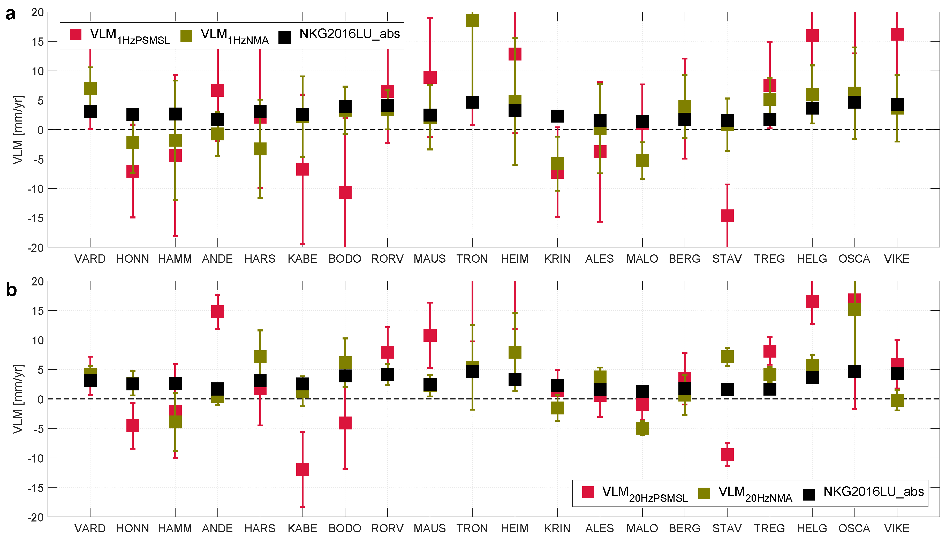
Present-day climate-change-related ice-melting induces elastic glacial isostatic adjustment (GIA) effects, while paleo-GIA effects describe the ongoing viscous response to the melting of late-Pleistocene ice sheets. The unloading initiated an uplift of the crust close to the centers of former ice sheets. Today, vertical land motion (VLM) rates in Fennoscandia reach values up to around 10 mm/year and are dominated by GIA. Uplift signals from GIA can be computed by solving the sea-level equation (SLE), S ˙ = N ˙ U ˙ . All three quantities can also be determined from geodetic observations: relative sea-level variations ( S ˙ ) are observed by means of tide gauges, while rates of absolute sea-level change ( N ˙ ) can be observed by satellite altimetry; rates of VLM ( U ˙ ) can be determined by GPS (Global Positioning System). Based on the SLE, U ˙ can be derived by combining sea-surface measurements from satellite altimetry and relative sea-level records from tide gauges. In the present study, we have combined 7.5 years of CryoSat-2 satellite altimetry and tide-gauge data to estimate linear VLM rates at 20 tide gauges along the Norwegian coast. Thereby, we made use of monthly averaged tide-gauge data from PSMSL (Permanent Service for Mean Sea Level) and a high-frequency tide-gauge data set with 10-min sampling rate from NMA (Norwegian Mapping Authority). To validate our VLM estimates, we have compared them with the independent semi-empirical land-uplift model NKG2016LU_abs for the Nordic-Baltic region, which is based on GPS, levelling, and geodynamical modeling. Estimated VLM rates from 1 Hz CryoSat-2 and high-frequency tide-gauge data reflect well the amplitude of coastal VLM as provided by NKG2016LU_abs. We find a coastal average of 2.4 mm/year (average over all tide gauges), while NKG2016LU_abs suggests 2.8 mm/year; the spatial correlation is 0.58.
Keywords: CryoSat-2; tide gauges; Norwegian coast; vertical land motion; land-uplift model CryoSat-2; tide gauges; Norwegian coast; vertical land motion; land-uplift model