Joint Retrieval of Growing Season Corn Canopy LAI and Leaf Chlorophyll Content by Fusing Sentinel-2 and MODIS Images

 ,
,  , ,
, ,  and
and
Abstract
:
1. Introduction
- Can the Kalman filter be used to fuse Sentinel-2 and MODIS reflectances for producing higher spatial and temporal resolutions images?
- Can the corn canopy LAI and chlorophyll content be retrieved jointly and accurately during the entire corn growing season? Which growing stages are retrieved better?
- Can the retrieved time series of LAI and chlorophyll content be used to monitor the corn growing behavior and how?
2. Materials and Pre-Processing
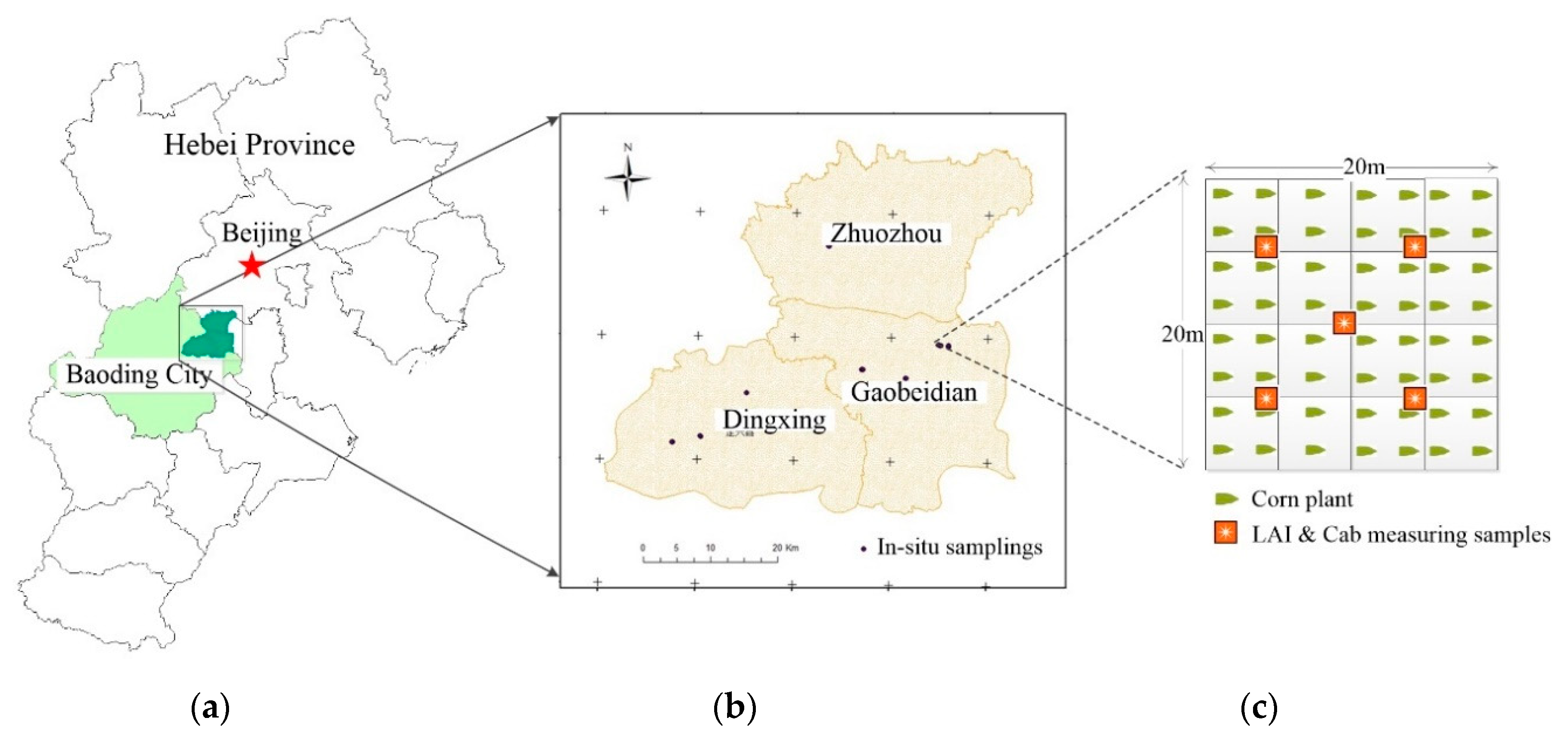
2.1. Study Area
2.2. Field Data Collection
 ”. The parameters collected included LAI, chlorophyll content of corn leaves, and spectra of corn canopy, corn leaves, and soil. There were 61 in-situ measured samplings distributed in these three counties of Zhouzhou, Gaobeidian and Dingxing randomly and evenly. All the samplings were geolocated using a Huace i80 real-time kinematic (RTK) GPS receiver (Huace Ltd., Shanghai, China). Corn canopy LAI was measured using an LAI-2200 Plant Canopy Analyzer (LI-COR, Lincoln, NE, USA) with a 45° field angle to eliminate the effect of non-plant objects within the range of the sensor’s field of view. For each in situ LAI measurement, two repeats were done including one above canopy and four below canopy readings [39].
2.3. Remote Sensing Images and Pre-Processing
3. Methods
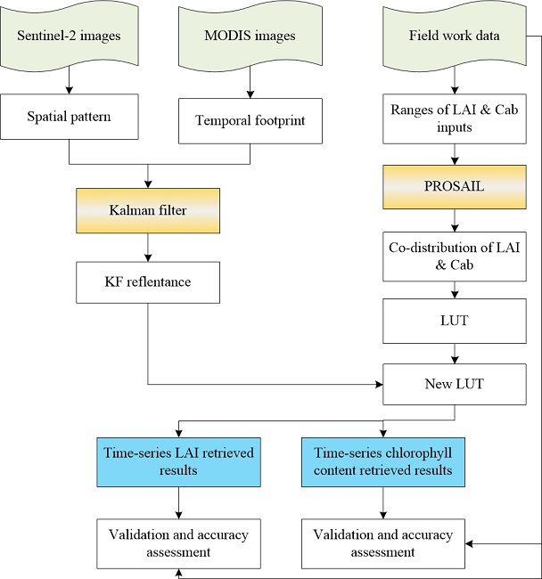
3.1. Fusing Sentinel-2 and MODIS Images for Time Series Synthetic Images
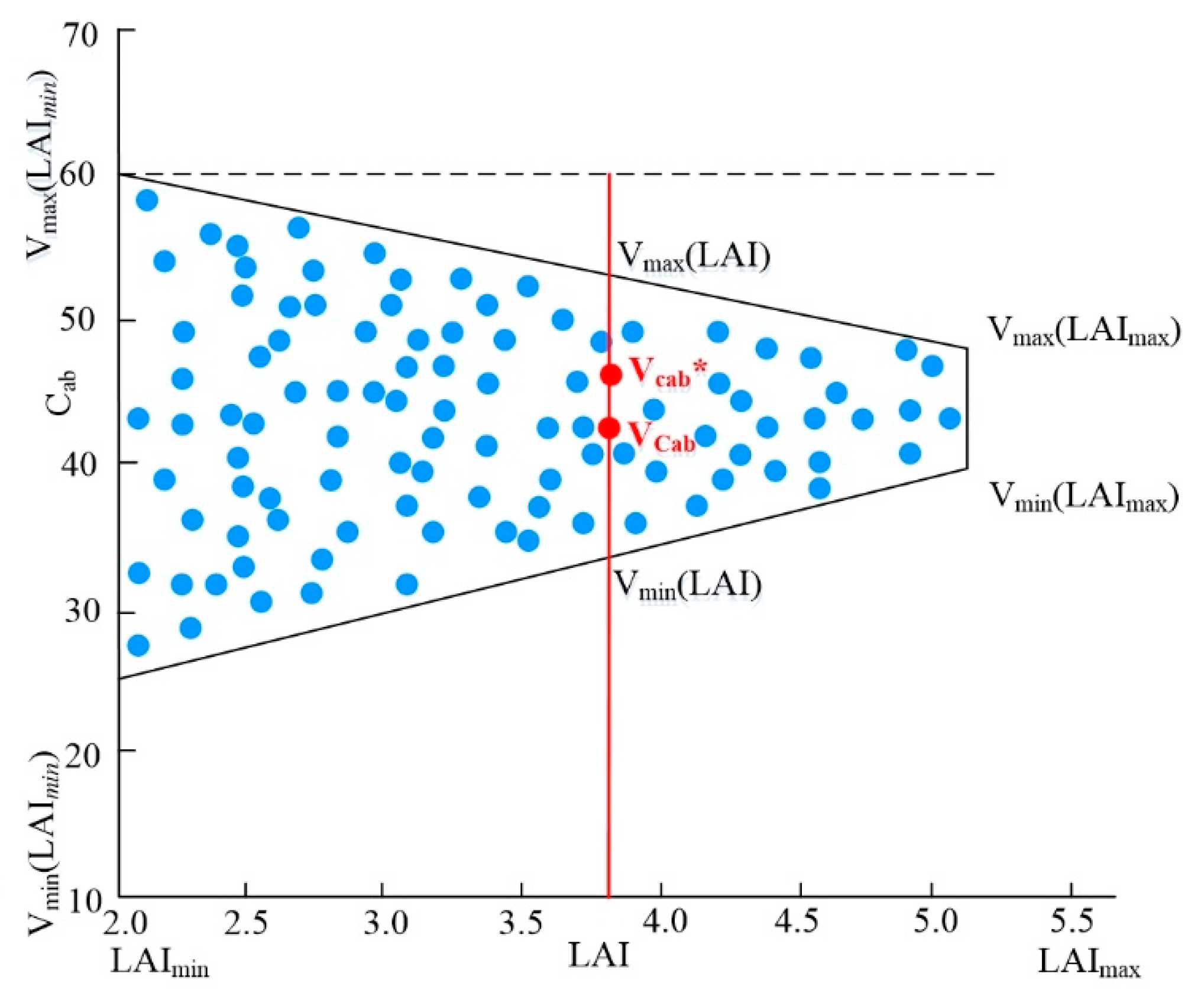
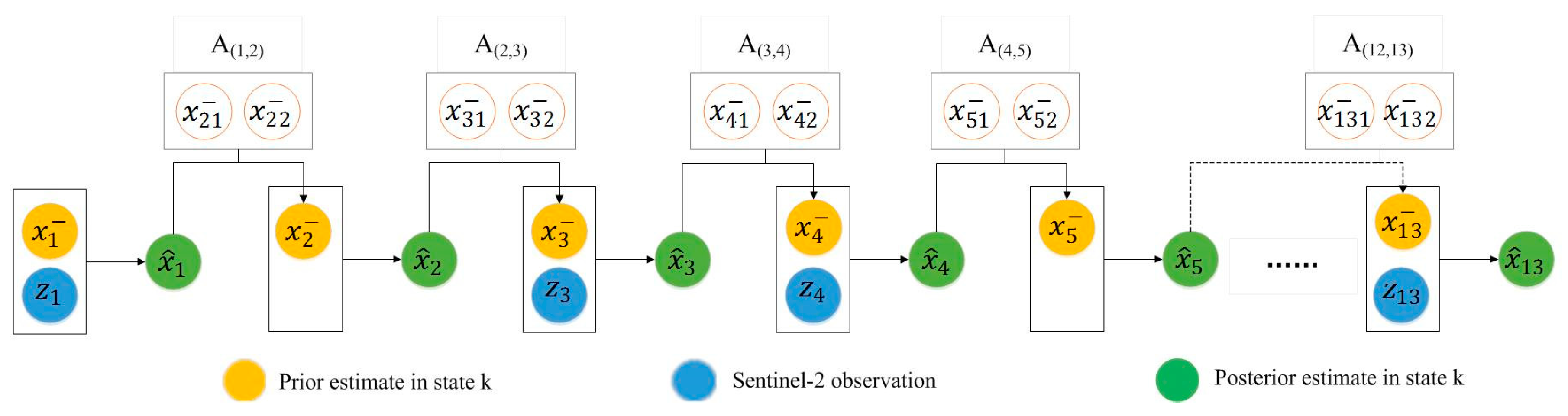
3.2. Joint Retrieval of Growing Season Corn Canopy LAI and Chlorophyll Content
4. Results and Analysis
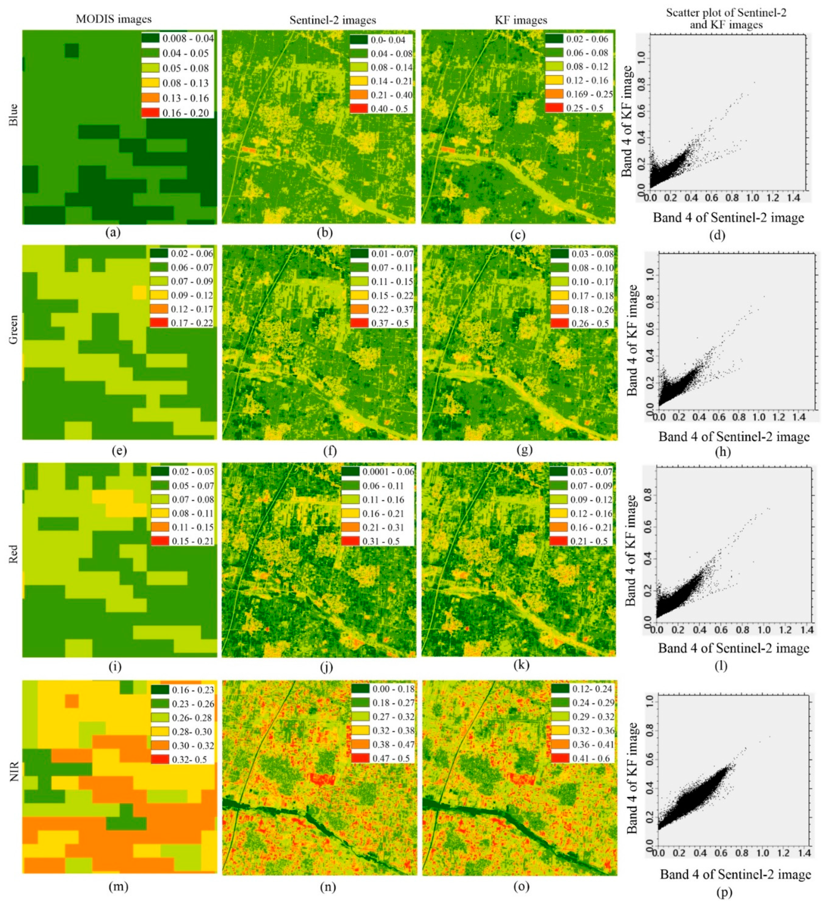
4.1. Spatial Distribution of the Synthetic KF Reflectance
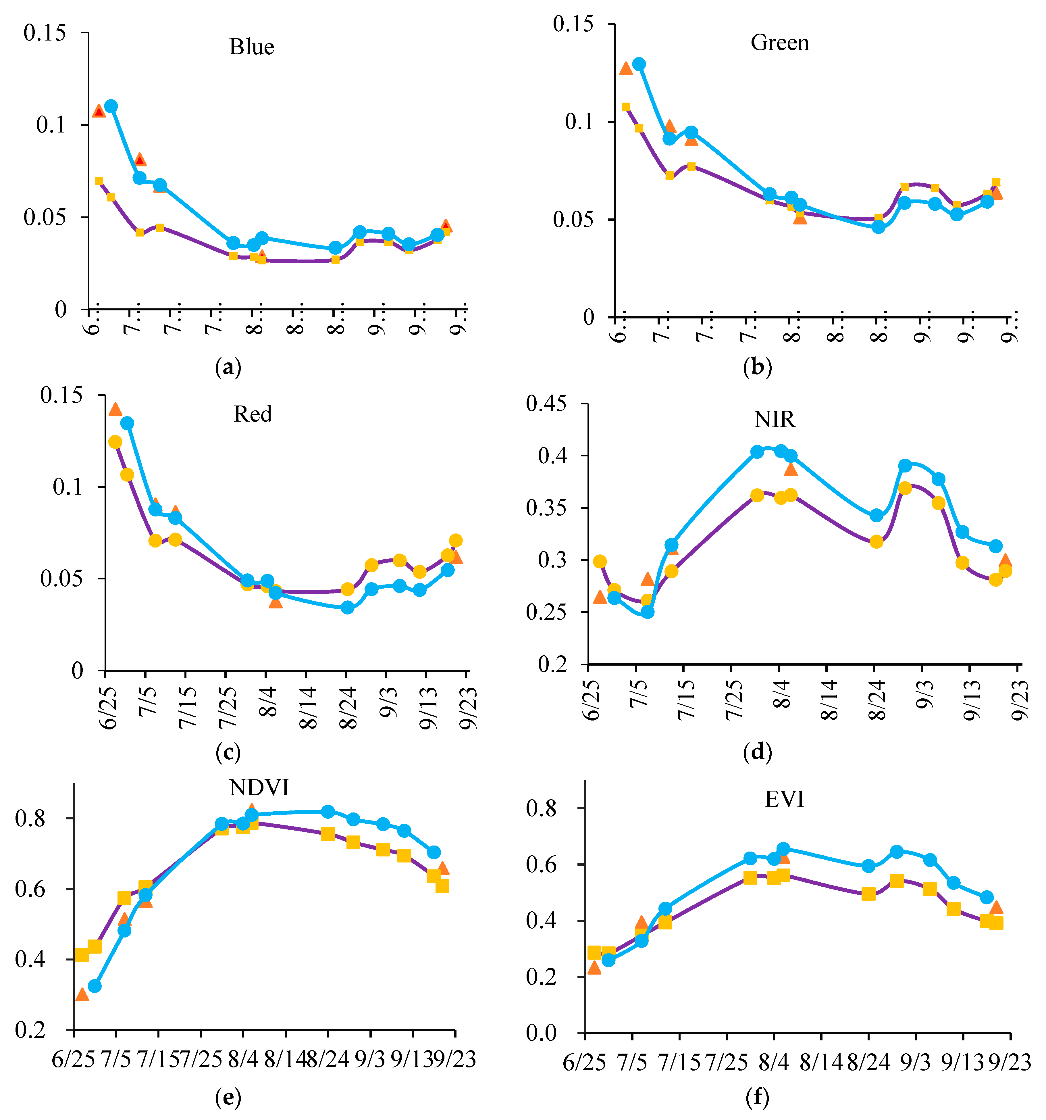
4.2. Time Series of Synthetic KF Reflectance and NDVI, EVI
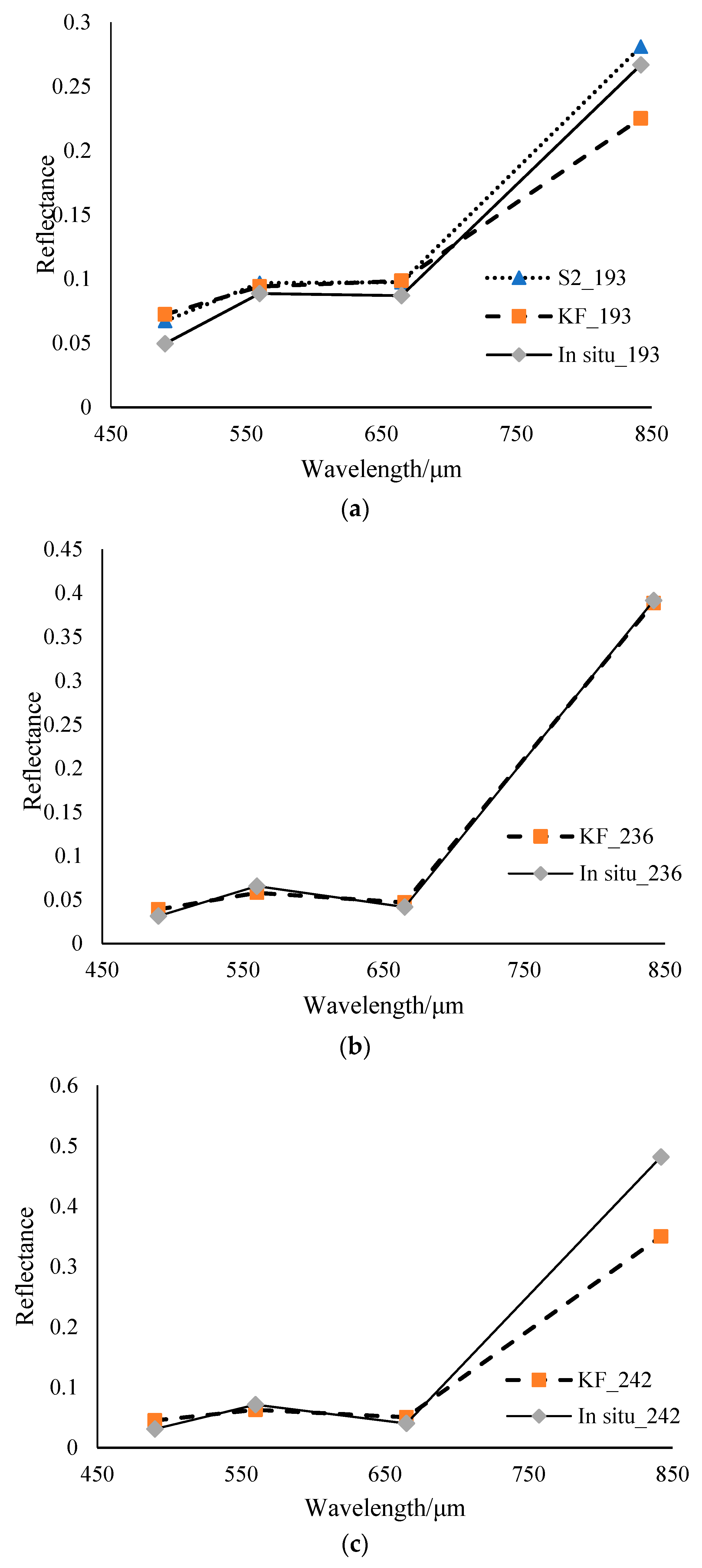
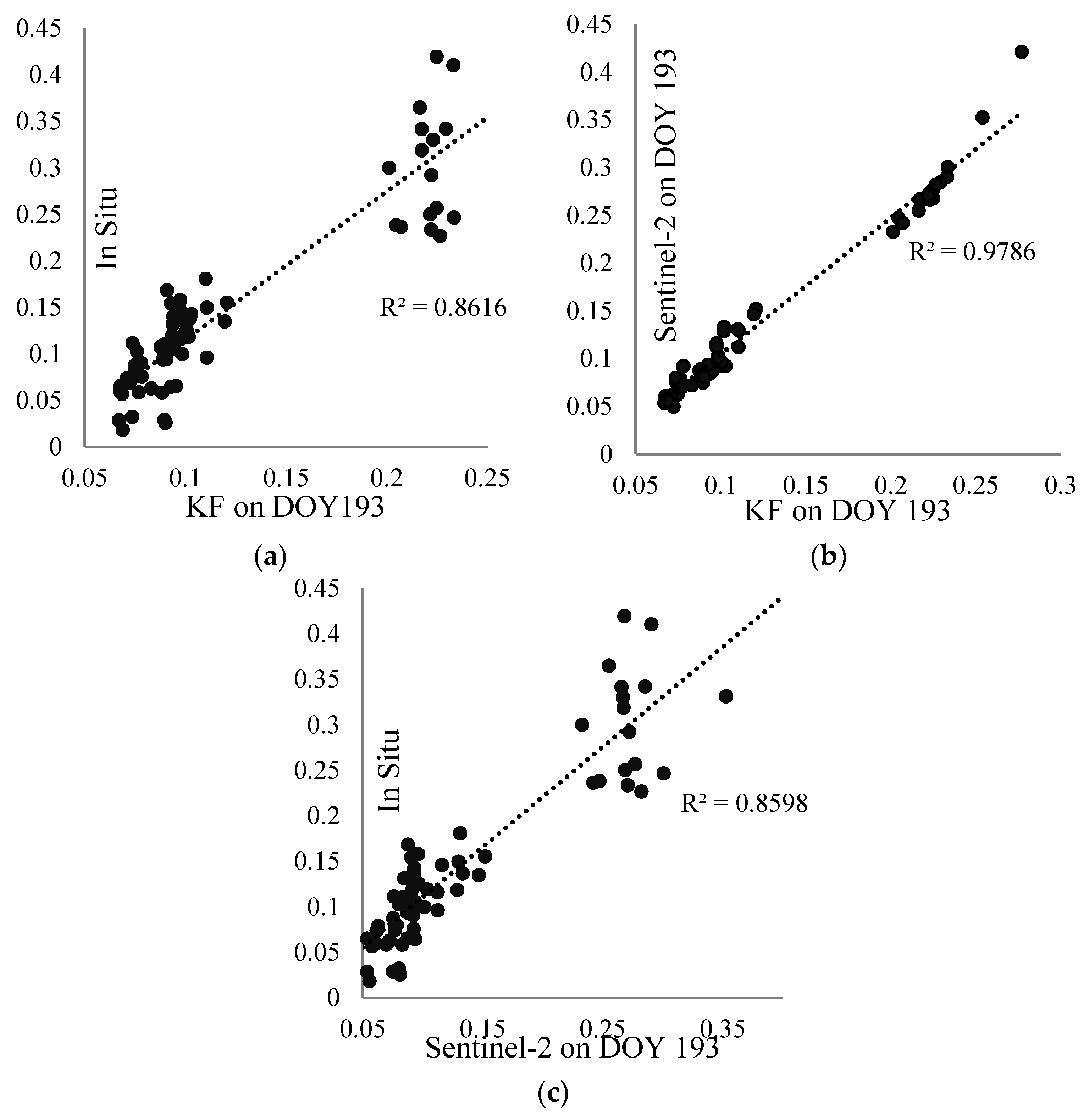
4.3. Accuracy Assessment of Synthetic KF Reflectance using Field-Measured Reflectance
4.4. Accuracy Assessment of Joint Retrieval of LAI and Chlorophyll Content Using Field-Measured Data
4.5. Comparison of Retrieval of LAI and Chlorophyll Content Using Synthetic KF and Sentinel-2 Images
4.6. Monitoring the Corn Growth Behavior by Retrieved Time Series of LAI and Chlorophyll Content
5. Discussions
5.1. Remote Sensing Image Fusing by Kalman Filter
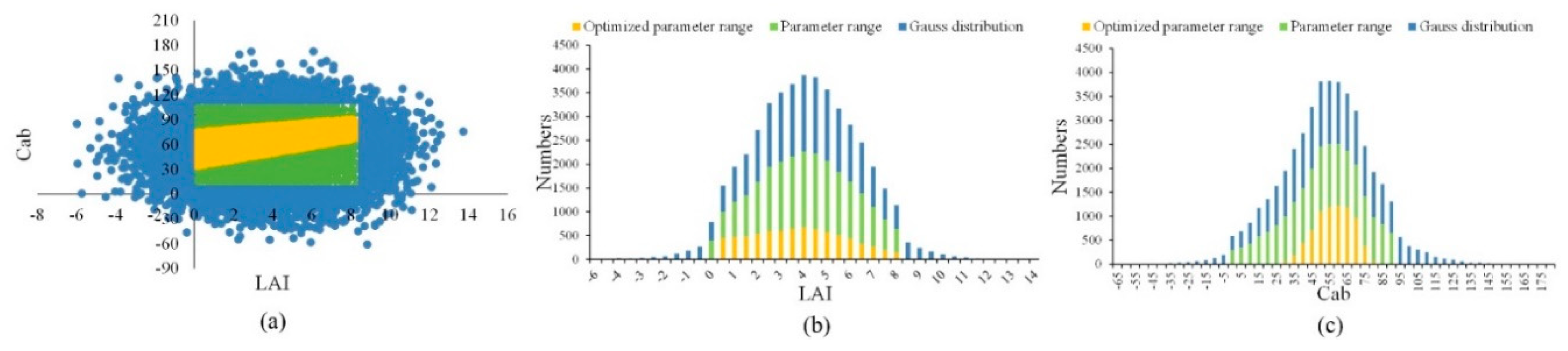
5.2. Joint Retrieval of Corn Canopy LAI and Leaf Chlorophyll Using Co-Distributions
6. Conclusions
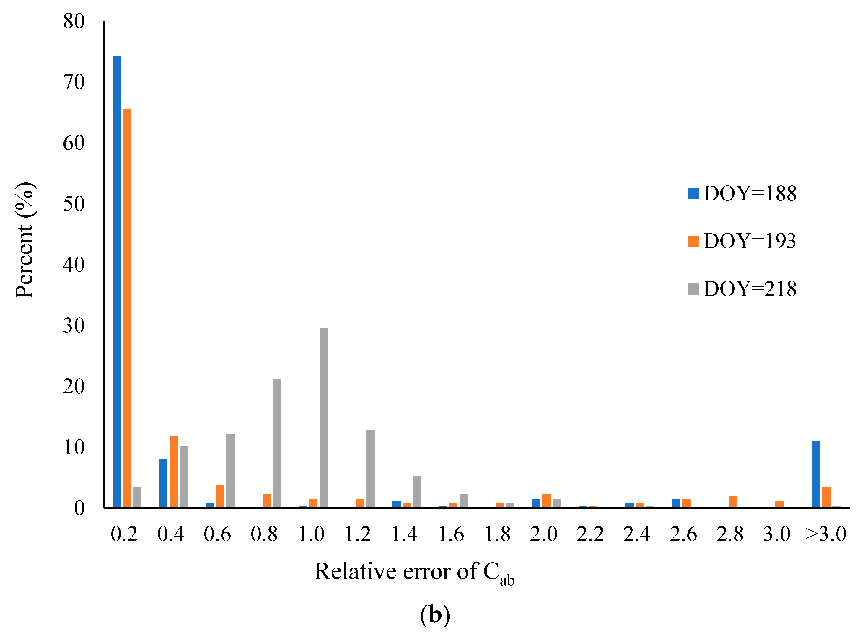
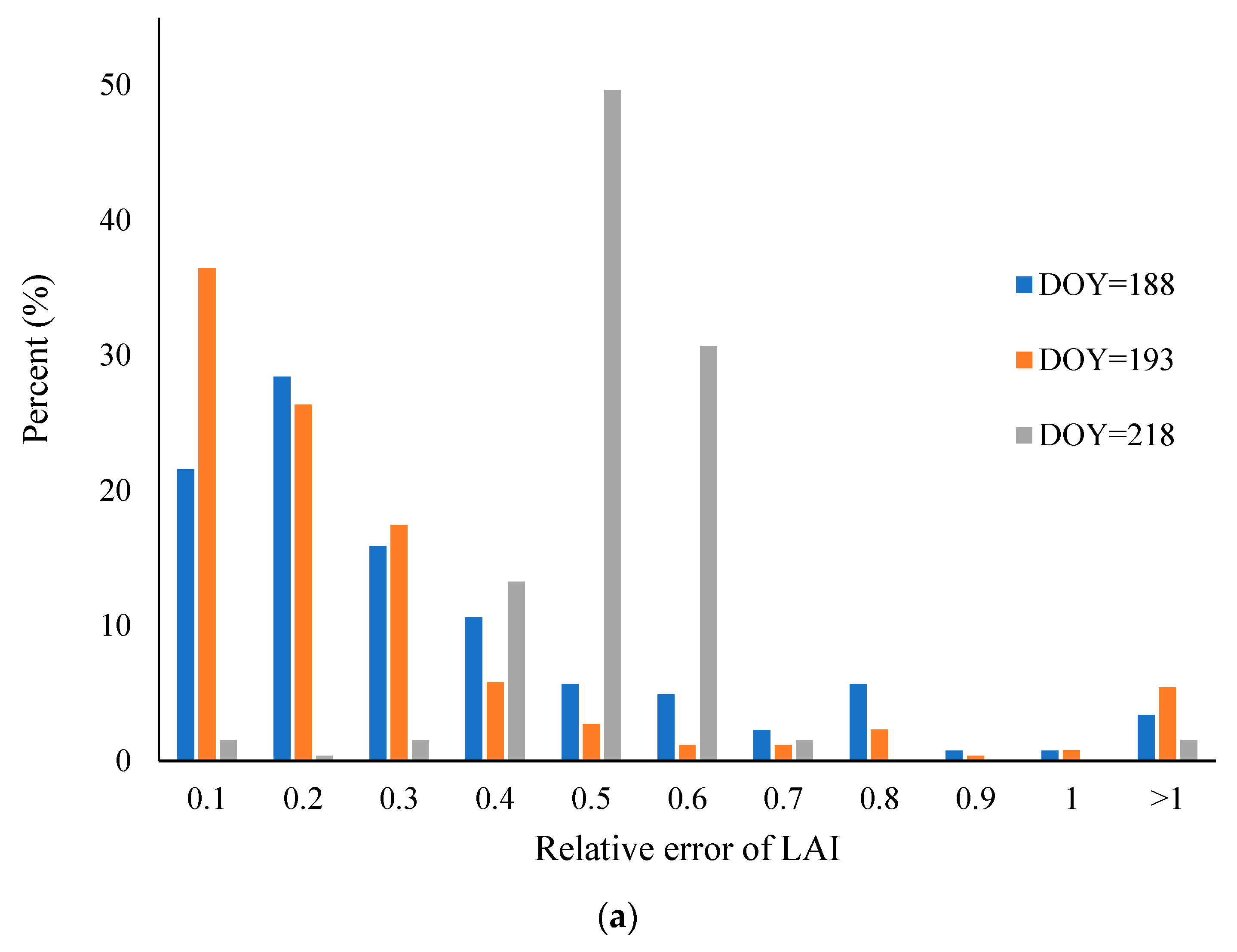
- The joint retrieval of LAI and chlorophyll content using the proposed joint probability distribution method demonstrated a good performance when compared with ground data. The R2 value between the retrieved and measured parameters for four growth stages was about 0.6 for both LAI and chlorophyll content. Furthermore, the retrieval accuracy of the synthetic KF images was also assessed. The relative error between the retrieved and measured LAI and chlorophyll content were mainly distributed within the range of 0.1–0.2 μg/cm2 and 0.0–0.3 μg/cm2, respectively.
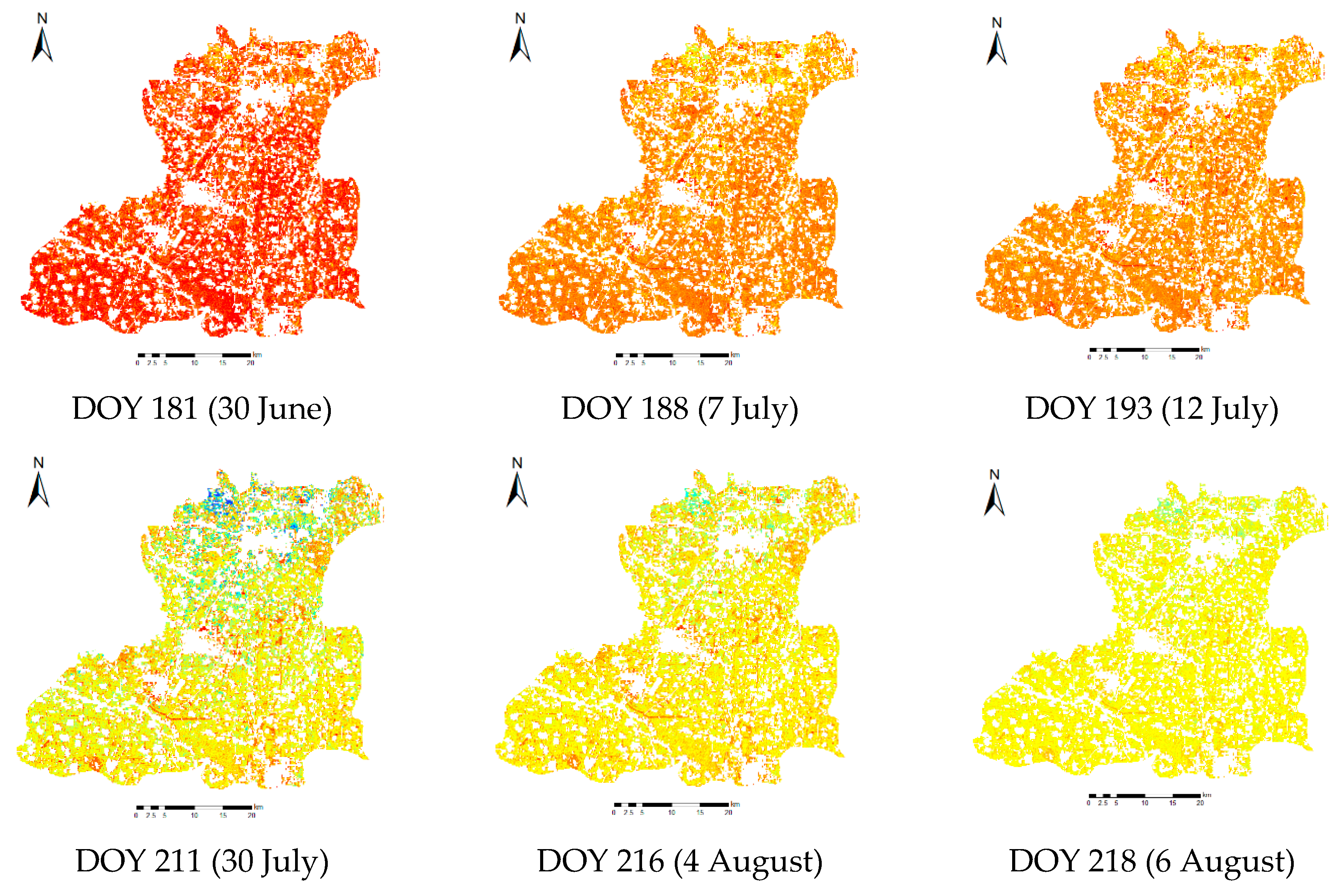
- Kalman filtering appeared to be a viable technique for producing continuous high-resolution reflectance images from synthesizing Sentinel-2 and MODIS reflectances. There was a significant correlation between the synthetic KF and the Sentinel-2 images both in the spatial structure and in their time series. There was almost no land cover structure difference between the Sentinel-2 and synthetic KF images, which could be confirmed by the fact that the points in the scatter plots for the blue, green, and red bands were close to the 1:1 line, while there was a bias on the scatter plot of the NIR band. In addition, the time series of synthetic blue, green, red, and NIR reflectances, NDVI, and EVI were all very similar to those of MODIS.
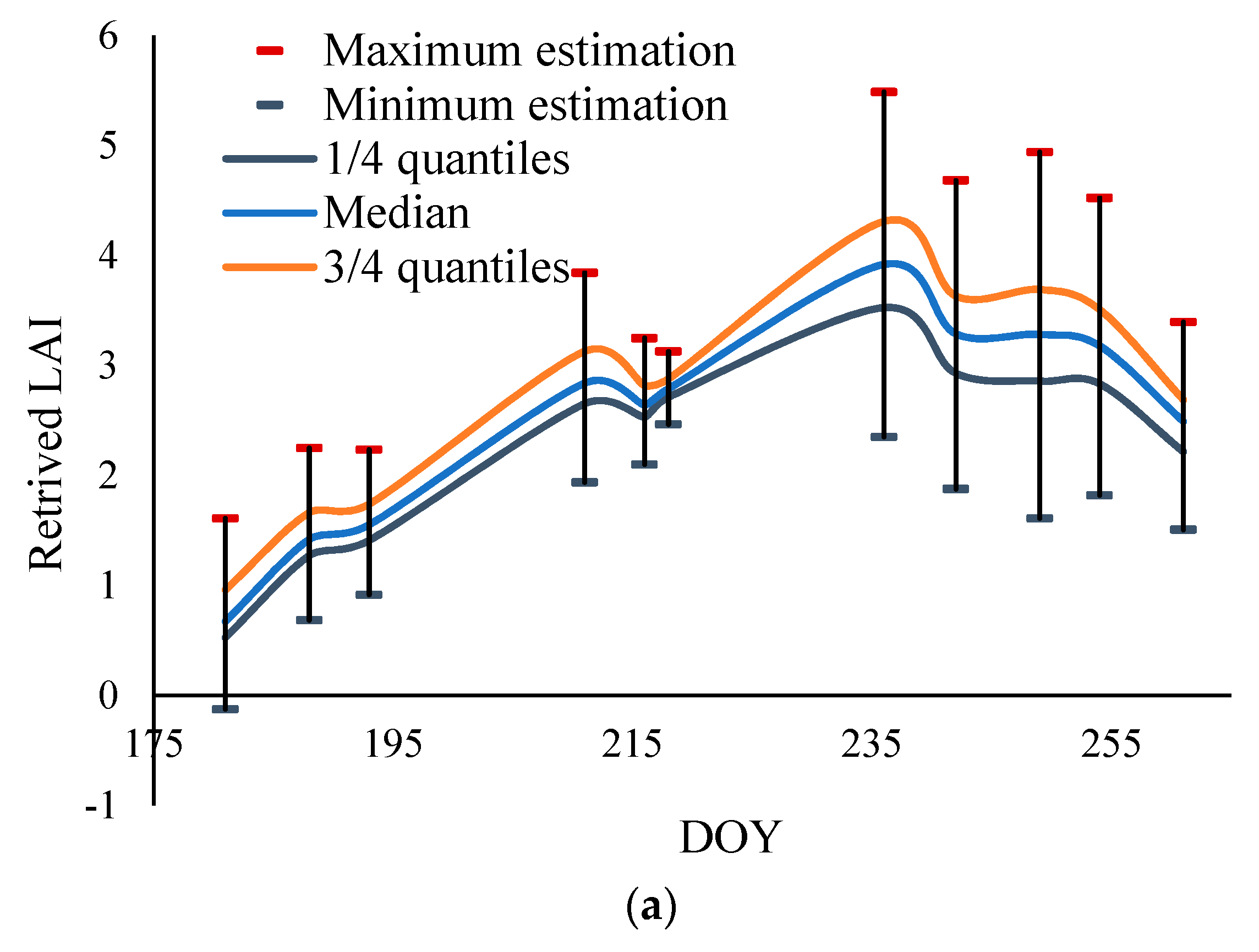
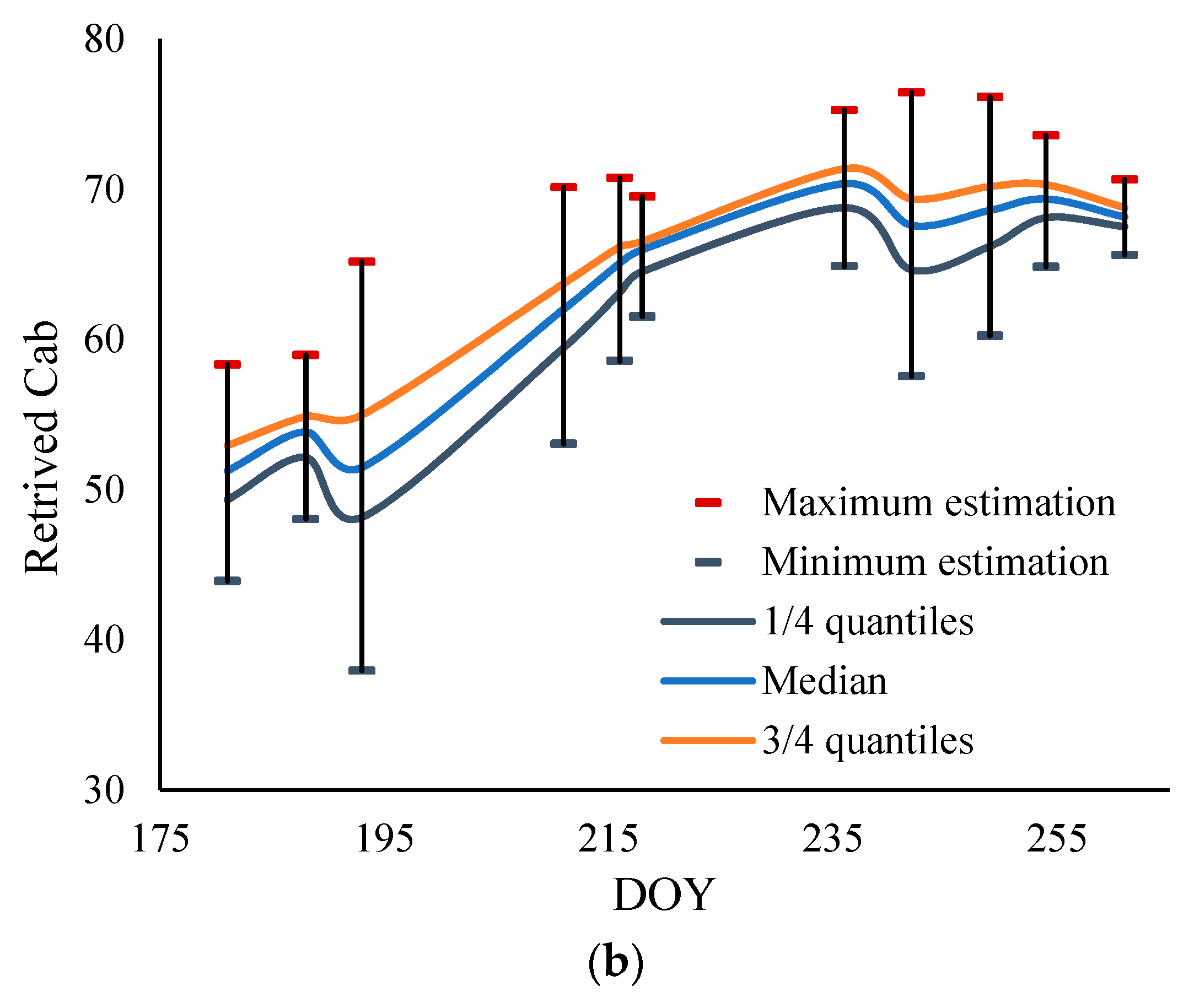
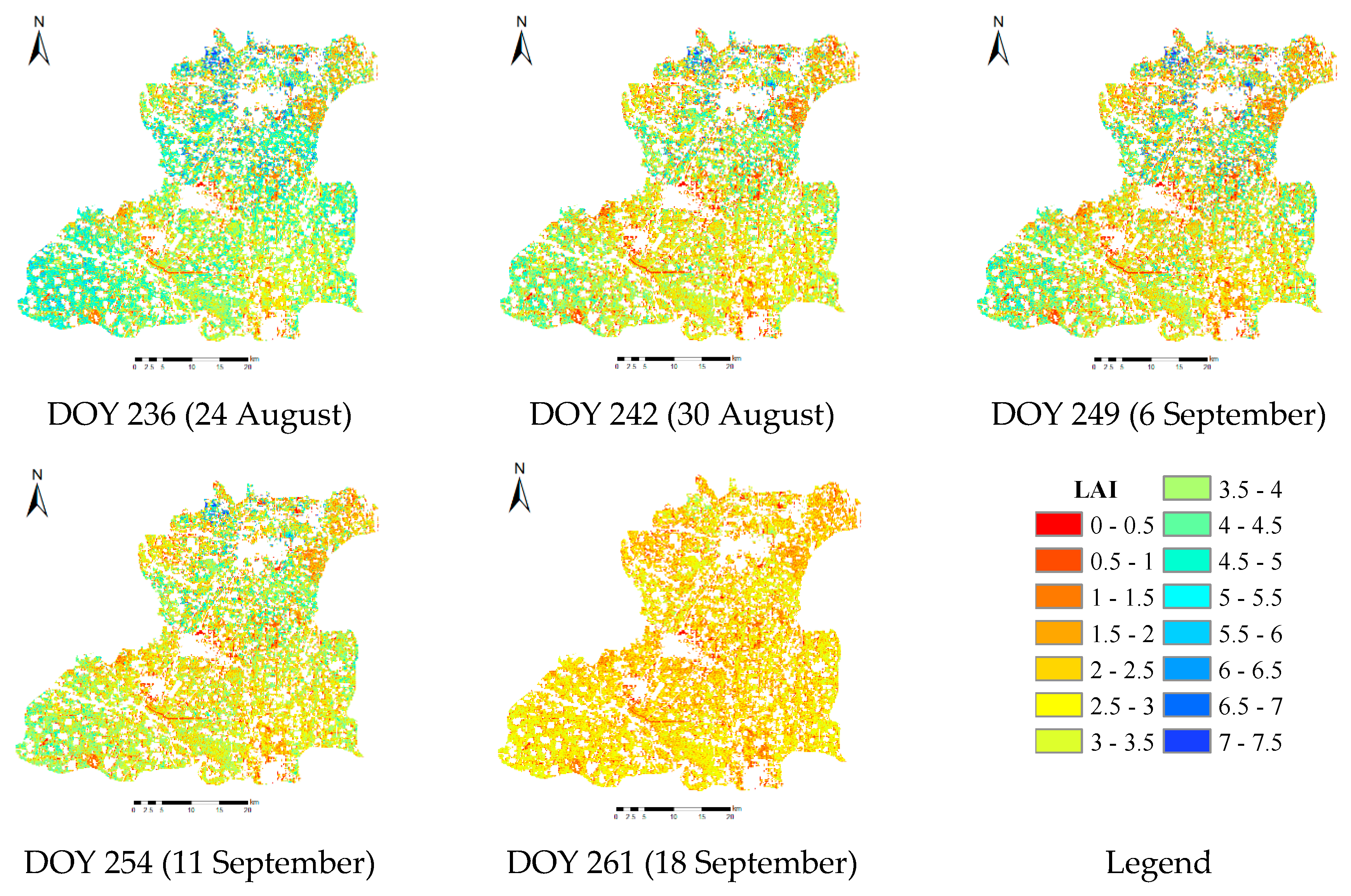
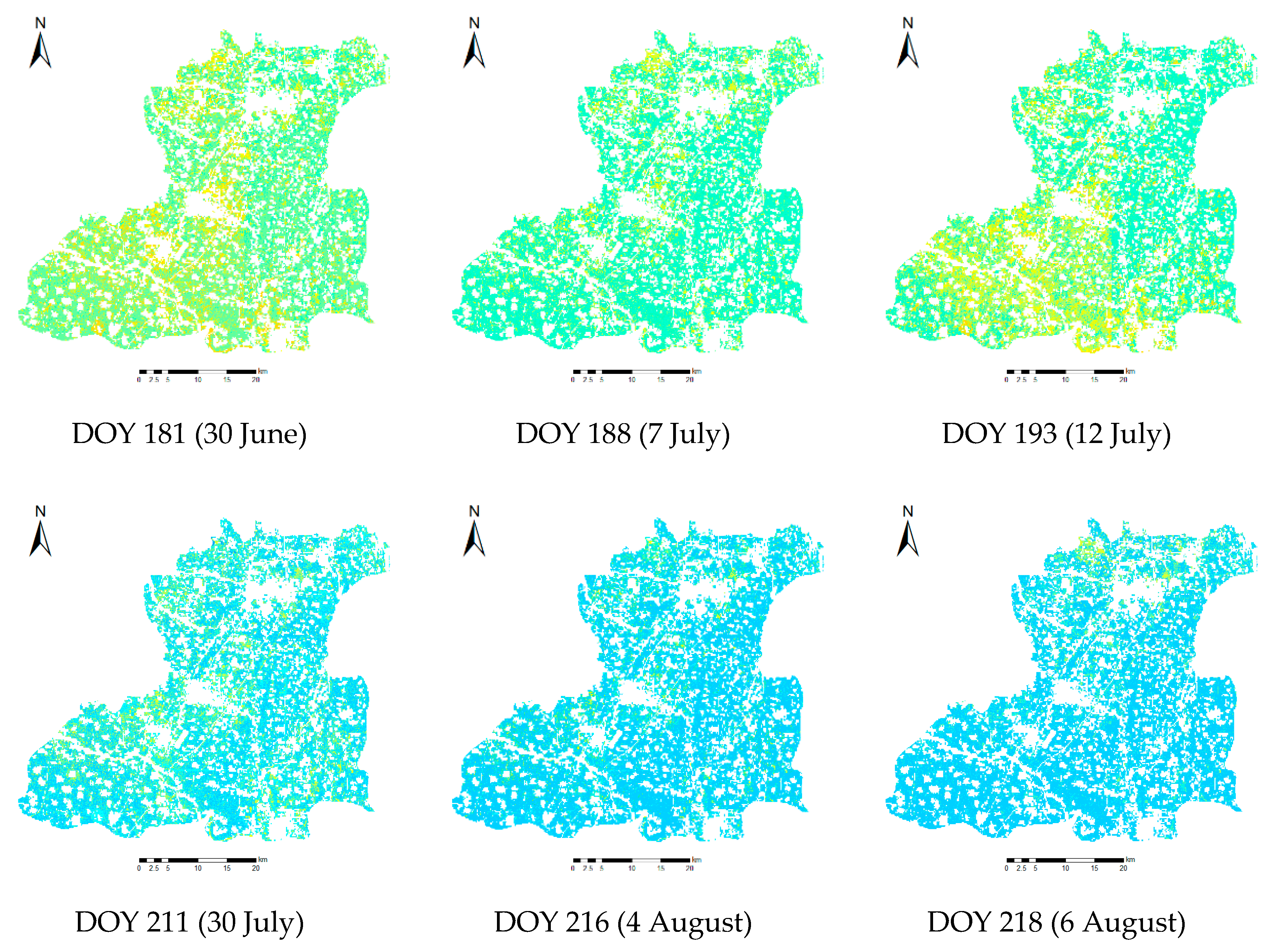
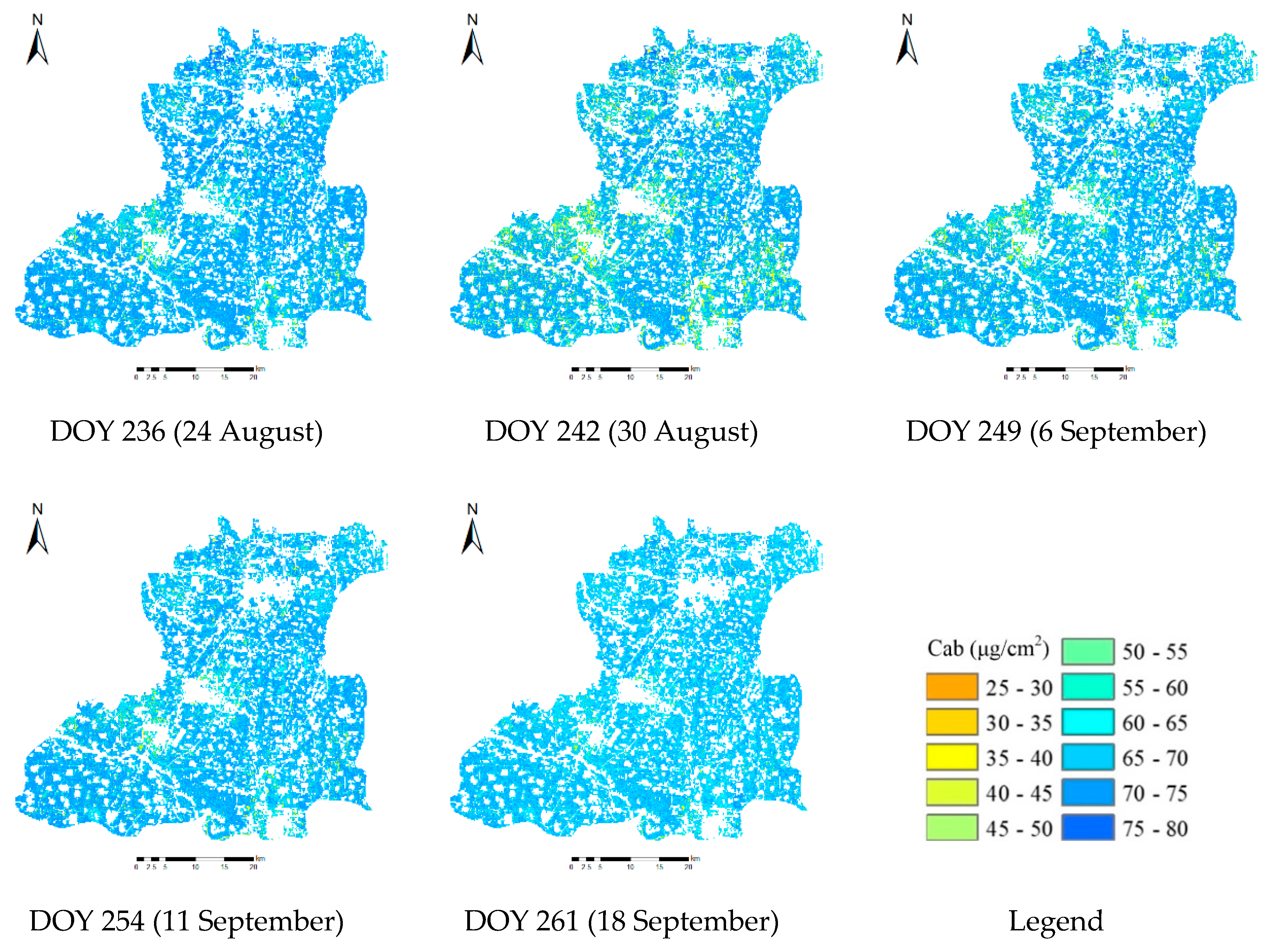
- Continuous KF reflectances were useful for monitoring the corn growth behavior during the entire growing season. Our analysis demonstrated that the LAI increased from DOY 181 (trefoil stage) to DOY 236 (filling stage), and then increased until the corn was harvested. Additionally, the results showed that chlorophyll content also increased from DOY 181 to DOY 236, and then remained stable until harvest. Compared with LAI, the chlorophyll content remained relatively stable during the growing season, ranging from 50 to 70 μg/cm2.
Author Contributions
Funding
Conflicts of Interest
References
- Yang, C.H.; Everitt, J.H.; Du, Q.; Luo, B.; Chanussot, J. Using high-resolution airborne and satellite imagery to assess crop growth and yield variability for precision agriculture. Proc. IEEE 2013, 101, 582–592. [Google Scholar] [CrossRef]
- Tucker, C.J., Jr.; Elgin, J.H.; McMurtey, J.E., III; Fan, C.J. Monitoring corn and soybean crop development with hand-held radiometer spectral data. Remote Sens. Environ. 1979, 8, 237–248. [Google Scholar] [CrossRef]
- Haboudane, D.; Miller, J.R.; Tremblay, N.; Zarco-Tejada, P.J.; Dextraze, L. Integrated narrow-band vegetation indices for prediction of crop chlorophyll content for application to precision agriculture. Remote Sens. Environ. 2002, 81, 416–426. [Google Scholar] [CrossRef]
- Chen, J.M.; Black, T.A. Defining leaf area index for non-flat leaves. Plant Cell Environ. 2010, 15, 421–429. [Google Scholar] [CrossRef]
- Fang, H.; Ye, Y.; Liu, W.; Wei, S.; Ma, L. Continuous estimation of canopy leaf area index (LAI) and clumping index over broadleaf crop fields: An investigation of the PASTIS-57 instrument and smartphone applications. Agric. For. Meteorol. 2018, 253–254, 48–61. [Google Scholar] [CrossRef]
- Su, W.; Zhang, M.Z.; Bian, D.H.; Liu, Z.; Huang, J.X.; Wang, W.; Wu, J.Y.; Guo, H. Phenotyping of Corn Plants Using Unmanned Aerial Vehicle (UAV) Images. Remote Sens. 2019, 11, 2021. [Google Scholar] [CrossRef]
- Gitelson, A.A.; Gritz, Y.; Merzlyak, M.N. Relationships between leaf chlorophyll content and spectral reflectance and algorithms for non-destructive chlorophyll assessment in higher plant leaves. J. Plant Physiol. 2003, 160, 271–282. [Google Scholar] [CrossRef]
- Daughtry, C.S.T.; Walthall, C.L.; Kim, M.S.; Brown de Colstoun, E.; McMurtrey, J.E., III. Estimating corn leaf chlorophyll concentration from leaf and canopy reflectance. Remote Sens. Environ. 2000, 74, 229–239. [Google Scholar] [CrossRef]
- GCOS. The Global Observing System for Climate: Implementation Needs (GCOS-200). World Meteorological Organization, 2016. Available online: https://library.wmo.int/opac/doc_num.php?explnum_id=3417 (accessed on 17 October 2018).
- Huang, J.; Zhuo, W.; Li, Y.; Huang, R.; Sedano, F.; Su, W.; Dong, J.; Tian, L.; Huang, Y.; Zhu, D.; et al. Comparison of three remotely sensed drought indices for assessing the impact of drought on winter wheat yield. Int. J. Digit. Earth 2018. [Google Scholar] [CrossRef]
- Huang, J.; Gómez-Dans, J.; Huang, H.; Ma, H.; Wu, Q.; Lewis, P.; Liang, S.; Chen, Z.; Xue, J.; Wu, Y.; et al. Assimilation of remote sensing into crop growth models: Current status and perspectives. Agric. For. Meteorol. 2019, 276–277, 107609. [Google Scholar] [CrossRef]
- Merzlyak, M.N.; Gitelson, A.A.; Chivkunova, O.B.; Rakitin, V.Y. Non-destructive optical detection of pigment changes during leaf senescence and fruit ripening. Physiol. Plant. 2010, 106, 135–141. [Google Scholar] [CrossRef]
- Veloso, A.; Mermoz, S.; Bouvet, A.; Toan, T.L.; Planells, M.; Dejoux, J.F.; Ceschia, E. Understanding the temporal behavior of crops using Sentinel-1 and Sentinel-2-like data for agricultural applications. Remote Sens. Environ. 2017, 199, 415–426. [Google Scholar] [CrossRef]
- Huang, J.X.; Tian, L.Y.; Liang, S.L.; Ma, H.Y.; Becker-Reshef, I.; Su, W.; Huang, Y.B.; Zhang, X.D.; Zhu, D.H.; Wu, W.B. Improving winter wheat yield estimation by assimilation of the leaf area index from Landsat TM and MODIS data into the WOFOST model. Agric. For. Meteorol. 2015, 204, 106–121. [Google Scholar] [CrossRef] [Green Version]
- Huang, J.X.; Sedano, F.; Huang, Y.B.; Ma, H.Y.; Li, X.L.; Liang, S.L.; Tian, L.Y.; Zhang, X.D.; Fang, J.L.; Wu, W.B. Assimilating a synthetic Kalman filter leaf area index series into the WOFOST model to improve regional winter wheat yield estimation. Agric. For. Meteorol. 2016, 216, 188–202. [Google Scholar] [CrossRef]
- Chen, B.; Huang, B.; Xu, B. A hierarchical spatiotemporal adaptive fusion model using one image pair. Int. J. Digit. Earth 2017, 10, 639–655. [Google Scholar] [CrossRef]
- Gao, F.; Masek, J.; Schwaller, M.; Hall, F. On the blending of the Landsat and MODIS surface reflectance: Predicting daily Landsat surface reflectance. IEEE Trans. Geosci. Remote Sens. 2006, 44, 2207–2218. [Google Scholar]
- Zhu, X.; Chen, J.; Gao, F.; Chen, X.; Masek, J.G. An enhanced spatial and temporal adaptive reflectance fusion model for complex heterogeneous regions. Remote Sens. Environ. 2010, 114, 2610–2623. [Google Scholar] [CrossRef]
- Zhu, X.; Helmer, E.H.; Gao, F.; Liu, D.; Chen, J.; Lefsky, M.A. A flexible spatiotemporal method for fusing satellite images with different resolutions. Remote Sens. Environ. 2016, 172, 165–177. [Google Scholar] [CrossRef]
- Zhao, Y.; Huang, B.; Song, H.A. A robust adaptive spatial and temporal image fusion model for complex land surface changes. Remote Sens. Environ. 2018, 208, 42–62. [Google Scholar] [CrossRef]
- Roy, D.P.; Ju, J.; Lewis, P.; Schaaf, C.; Gao, F.; Hansen, M.; Lindquist, E. Multi-temporal MODIS-Landsat data fusion for relative radiometric normalization, gap filling, and prediction of Landsat data. Remote Sens. Environ. 2008, 112, 3112–3130. [Google Scholar] [CrossRef]
- Wang, Q.; Atkinson, P.M. Spatio-temporal fusion for daily Sentinel-2 images. Remote Sens. Environ. 2018, 204, 31–42. [Google Scholar] [CrossRef] [Green Version]
- Huang, B.; Song, H. Spatiotemporal reflectance fusion via sparse representation. IEEE Trans. Geosci. Remote Sens. 2012, 50, 3707–3716. [Google Scholar] [CrossRef]
- Mathieu, P.; O’Neill, A. Data assimilation: From photon counts to Earth System forecasts. Remote Sens. Environ. 2008, 112, 1258–1267. [Google Scholar] [CrossRef]
- Sedano, F.; Kempeneers, P.; Hurtt, G. A Kalman filter-based method to generate continuous time series of medium-resolution NDVI images. Remote Sens. 2014, 6, 12381–12408. [Google Scholar] [CrossRef]
- Darvishzadeh, R.; Skidmore, A.; Schlerf, M.; Atzberger, C. Inversion of a Radiative Transfer Model for Estimating Vegetation LAI and Chlorophyll in a Heterogeneous Grassland. Remote Sens. Environ. 2008, 112, 2592–2604. [Google Scholar] [CrossRef]
- Viña, A.; Gitelson, A.A.; Nguy-Robertson, A.L.; Peng, Y. Comparison of different vegetation indices for the remote assessment of green leaf area index of crops. Remote Sens. Environ. 2011, 115, 3468–3478. [Google Scholar] [CrossRef]
- Li, Z.H.; Xu, X.G.; Jin, X.J.; Gu, X.H. Retrieval of LAI and leaf chlorophyll content from remote sensing data by agronomy mechanism knowledge to solve the ill-posed inverse problem. SPIE Remote Sens. 2014, 9239, 92391Q. [Google Scholar]
- Jacquemoud, S.; Verhoef, W.; Baret, F.; Bacour, C.; Zarcotejada, P.J.; Asner, G.P.; François, C.; Ustin, S.L. PROSPECT+SAIL models: A review of use for vegetation characterization. Remote Sens. Environ. 2009, 113, S56–S66. [Google Scholar] [CrossRef]
- Verhoef, W. Light scattering by leaf layers with application to canopy reflectance modeling: The SAIL model. Remote Sens. Environ. 1984, 16, 125–141. [Google Scholar] [CrossRef] [Green Version]
- Jacquemoud, S.; Baret, F. PROSPECT: A model of leaf optical properties spectra. Remote Sens. Environ. 1990, 34, 75–91. [Google Scholar] [CrossRef]
- Baret, F.; Jacquemoud, S.; Guyot, G.; Leprieur, C. Modeled analysis of the biophysical nature of spectral shifts and comparison with information content of broad bands. Remote Sens. Environ. 1992, 41, 133–142. [Google Scholar] [CrossRef]
- Li, Z.H.; Jin, X.L.; Wang, J.H.; Yang, G.J.; Nie, C.W.; Xu, X.G.; Feng, H.K. Estimating winter wheat (triticum aestivum) LAI and leaf chlorophyll content from canopy reflectance data by integrating agronomic prior knowledge with the PROSAIL model. Int. J. Remote Sens. 2015, 36, 2634–2653. [Google Scholar] [CrossRef]
- Jay, S.; Maupas, F.; Bendoula, R.; Gorretta, N. Retrieving lai, chlorophyll and nitrogen contents in sugar beet crops from multi-angular optical remote sensing: Comparison of vegetation indices and prosail inversion for field phenotyping. Field Crop. Res. 2017, 210, 33–46. [Google Scholar] [CrossRef]
- Botha, E.J.; Leblon, B.; Zebarth, B.; Watmough, J. Non-destructive estimation of potato leaf chlorophyll from canopy hyperspectral reflectance using the inverted PROSAIL model. Int. J. Appl. Earth Obs. Geoinf. 2007, 9, 360–374. [Google Scholar] [CrossRef]
- Darvishzadeh, R.; Matkan, A.A.; Ahangar, A.D. Inversion of a radiative transfer model for estimation of rice canopy chlorophyll content using a lookup-table approach. IEEE J. Sel. Top. Appl. Earth Obs. Remote Sens. 2012, 5, 1222–1230. [Google Scholar] [CrossRef]
- Rivera, J.P.; Verrelst, J.; Leonenko, G.; Moreno, J. Multiple cost functions and regularization options for improved retrieval of leaf chlorophyll content and LAI through inversion of the PROSAIL model. Remote Sens. 2013, 5, 3280–3304. [Google Scholar] [CrossRef]
- Duan, S.B.; Li, Z.L.; Wu, H.; Tang, B.H.; Ma, L.; Zhao, E.Y.; Li, C.R. Inversion of the PROSAIL model to estimate leaf area index of maize, potato, and sunflower fields from unmanned aerial vehicle hyperspectral data. Int. J. Appl. Earth Obs. Geoinf. 2014, 26, 12–20. [Google Scholar] [CrossRef]
- Fang, H.; Li, W.; Wei, S.; Jiang, C. Seasonal variation of leaf area index (LAI) over paddy rice fields in NE China: Intercomparison of destructive sampling, LAI-2200, digital hemispherical photography (DHP), and AccuPAR methods. Agric. For. Meteorol. 2014, 198–199, 126–141. [Google Scholar] [CrossRef]
- Darvishzadeh, R.; Atzberger, C.; Skidmore, A.; Schlerf, M. Mapping grassland leaf area index with airborne hyperspectral imagery: A comparison study of statistical approaches and inversion of radiative transfer models. ISPRS J. Photogramm. Remote Sens. 2011, 66, 894–906. [Google Scholar] [CrossRef]
- Markwell, J.; Osterman, J.C.; Mitchell, J.L. Calibration of the Minolta SPAD-502 leaf chlorophyll meter. Photosynth. Res. 1995, 46, 467–472. [Google Scholar] [CrossRef]
- European Space Agency (ESA). The Sentinel Application Platform (SNAP), A Common Architecture for all Sentinel Toolboxes Being Jointly Developed by Brockmann Consult, Array Systems Computing and C-S. 2017. Available online: http://step.esa.int/main/download/ (accessed on 1 April 2017).
- Zhuo, W.; Huang, J.; Li, L.; Zhang, X.; Ma, H.; Gao, X.; Huang, H.; Xu, B.; Xiao, X. Assimilating Soil Moisture Retrieved from Sentinel-1 and Sentinel-2 Data into WOFOST Model to Improve Winter Wheat Yield Estimation. Remote Sens. 2019, 11, 1618. [Google Scholar] [CrossRef]
- Kalman, R.E. A new approach to linear filtering and prediction problems. J. Basic Eng. Trans. 1960, 82, 35–45. [Google Scholar] [CrossRef]
- Zhang, M.Z.; Zhu, D.H.; Su, W.; Huang, J.X.; Zhang, X.D.; Liu, Z. Harmonizing Multi-Source Remote Sensing Images for Summer Corn Growth Monitoring. Remote Sens. 2019, 11, 1266. [Google Scholar] [CrossRef]
- Baret, F.; Buis, S. Estimating Canopy Characteristics from Remote Sensing Observations: Review of Methods and Associated Problems. In Advances in Land Remote Sensing; Springer: Dordrecht, The Netherlands, 2008. [Google Scholar]
- Weiss, M.; Baret, F. S2ToolBox Level 2 Products. Version 1.1. Date Issued: 05 February 2016. Available online: step.esa.int/docs/extra/ATBD_S2ToolBox_L2B_V1.1.pdf (accessed on 17 October 2018).
- Su, W.; Huang, J.X.; Liu, D.S.; Zhang, M.Z. Retrieving corn canopy leaf area index from multitemporal Landsat imagery and terrestrial LiDAR data. Remote Sens. 2019, 11, 572. [Google Scholar] [CrossRef]
- Combal, B.; Baret, F.; Weiss, M.; Trubuil, A.; Macé, D.; Pragnère, A.; Myneni, R.; Knyazikhin, Y.; Wang, L. Retrieval of canopy biophysical variables from bidirectional reflectance: Using prior information to solve the ill-posed inverse problem. Remote Sens. Environ. 2002, 84, 1–15. [Google Scholar] [CrossRef]
- Locherer, M.; Hank, T.; Danner, M.; Mauser, W. Retrieval of seasonal leaf area index from simulated EnMAP data through optimized LUT-based inversion of the PROSAIL model. Remote Sens. 2015, 7, 10321–10346. [Google Scholar] [CrossRef]
- Xu, M.Z.; Liu, R.G.; Chen, J.M.; Liu, Y.; Shang, R.; Ju, W.M.; Wu, C.Y.; Huang, W.J. Retrieving leaf chlorophyll content using a matrix-based vegetation index combination approach. Remote Sens. Environ. 2019, 224, 60–73. [Google Scholar] [CrossRef]


| Stage | ||||||
|---|---|---|---|---|---|---|
| 1 | 0.100 | 30.249 | 54.100 | 3.590 | 42.623 | 59.919 |
| 2 | 0.570 | 34.039 | 63.823 | 5.851 | 47.358 | 70.469 |
| 3 | 1.621 | 32.227 | 65.973 | 6.491 | 48.557 | 73.932 |
| 4 | 1.991 | 40.212 | 69.956 | 6.580 | 52.002 | 75.979 |
| 5 | 1.341 | 44.960 | 69.690 | 6.111 | 56.924 | 75.728 |
| LAI | Cab (μg/cm2) | |||||||||||
|---|---|---|---|---|---|---|---|---|---|---|---|---|
| DOY | Correlation | R2 | RMSE | Bias | EA (%) | SD | Correlation | R2 | RMSE | Bias | EA (%) | SD |
| 193 | y = 1.74x − 1.66 | 0.62 | 0.30 | 0.60 | 63.90 | 0.21 | y = 4.86x − 226.76 | 0.49 | 3.18 | 11.59 | 92.78 | 0.62 |
| 211 | y = 0.74x + 1.04 | 0.53 | 0.30 | 0.36 | 90.56 | 0.42 | y = 0.74x − 2.70 | 0.59 | 0.77 | 19.69 | 98.31 | 1.21 |
| 236 | y = 0.76x + 0.81 | 0.62 | 0.36 | 0.38 | 91.67 | 0.60 | y = 1.38x − 41.38 | 0.63 | 1.07 | 13.51 | 98.19 | 0.99 |
| 242 | y = 0.65x + 1.41 | 0.60 | 0.30 | 0.29 | 92.55 | 0.56 | y = 4.24x − 255.36 | 0.66 | 3.05 | 21.25 | 94.01 | 0.98 |
© 2019 by the authors. Licensee MDPI, Basel, Switzerland. This article is an open access article distributed under the terms and conditions of the Creative Commons Attribution (CC BY) license (http://creativecommons.org/licenses/by/4.0/).
Share and Cite
Su, W.; Sun, Z.; Chen, W.-h.; Zhang, X.; Yao, C.; Wu, J.; Huang, J.; Zhu, D. Joint Retrieval of Growing Season Corn Canopy LAI and Leaf Chlorophyll Content by Fusing Sentinel-2 and MODIS Images. Remote Sens. 2019, 11, 2409. https://doi.org/10.3390/rs11202409
Su W, Sun Z, Chen W-h, Zhang X, Yao C, Wu J, Huang J, Zhu D. Joint Retrieval of Growing Season Corn Canopy LAI and Leaf Chlorophyll Content by Fusing Sentinel-2 and MODIS Images. Remote Sensing. 2019; 11(20):2409. https://doi.org/10.3390/rs11202409
Chicago/Turabian StyleSu, Wei, Zhongping Sun, Wen-hua Chen, Xiaodong Zhang, Chan Yao, Jiayu Wu, Jianxi Huang, and Dehai Zhu. 2019. "Joint Retrieval of Growing Season Corn Canopy LAI and Leaf Chlorophyll Content by Fusing Sentinel-2 and MODIS Images" Remote Sensing 11, no. 20: 2409. https://doi.org/10.3390/rs11202409
APA StyleSu, W., Sun, Z., Chen, W.-h., Zhang, X., Yao, C., Wu, J., Huang, J., & Zhu, D. (2019). Joint Retrieval of Growing Season Corn Canopy LAI and Leaf Chlorophyll Content by Fusing Sentinel-2 and MODIS Images. Remote Sensing, 11(20), 2409. https://doi.org/10.3390/rs11202409