The Magnitude of Diurnal/Semidiurnal Atmospheric Tides (S1/S2) and Their Impacts on the Continuous GPS Coordinate Time Series




Abstract
1. Introduction
2. S1/S2 Modeling
3. GPS Data Reprocessing
4. Results and Discussion
4.1. The 24-h GPS Daily Position Difference Caused by S1/S2 Tides
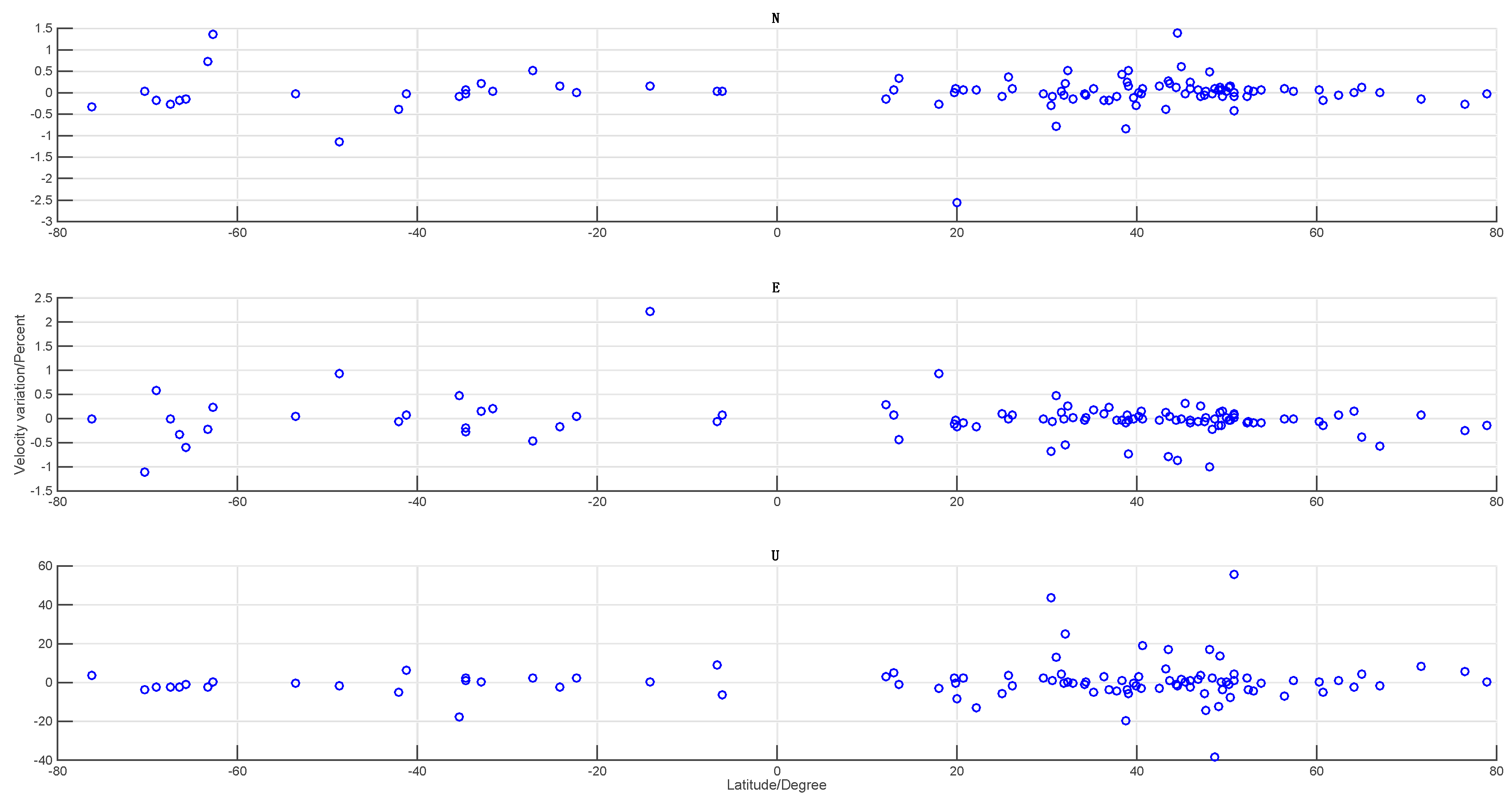
4.2. The S1/S2 Effects on the Long-Term Velocity of Global IGS Stations
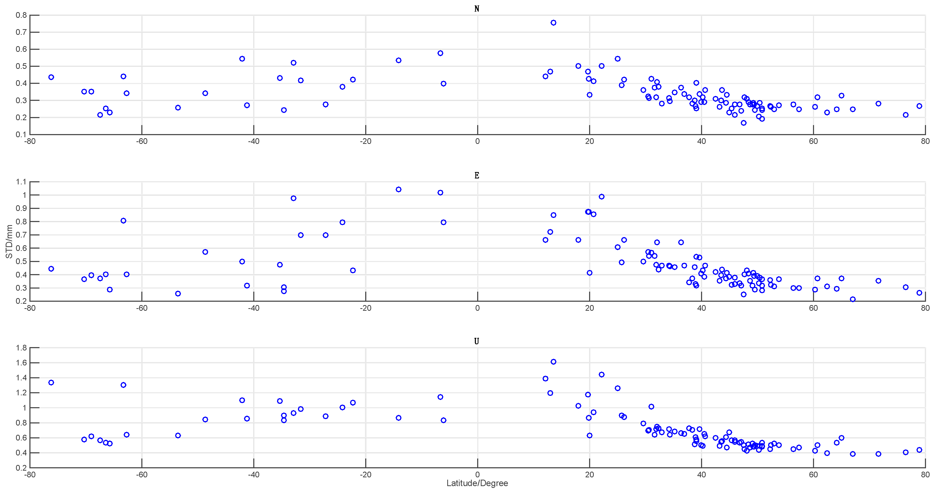
4.3. Weighted Root Mean Square (WRMS) Analysis
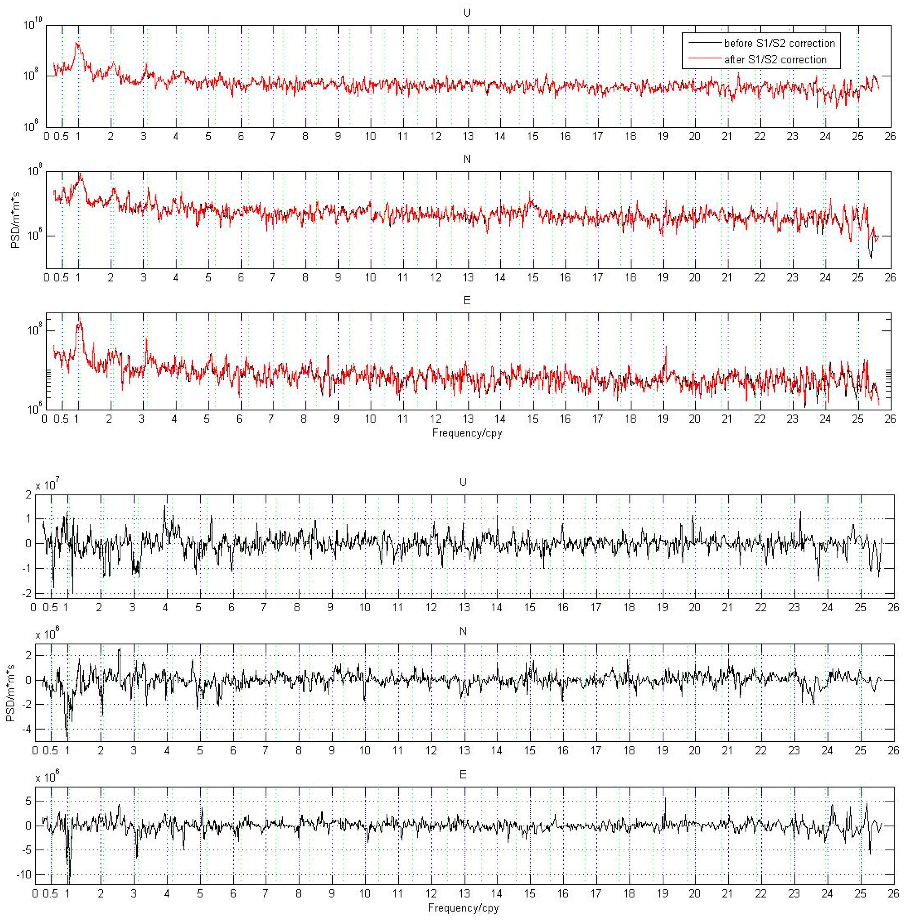
4.4. Spectral Analysis
5. Conclusions
Supplementary Materials
Author Contributions
Funding
Acknowledgments
Conflicts of Interest
References
- Dai, A.; Deser, C. Diurnal variation in global surface wind fields. J. Geophys. Res. 1999, 104, 31109–31125. [Google Scholar] [CrossRef] [Scilit]
- Petrov, L.; Boy, J.P. Study of the atmospheric pressure loading signal in very long baseline interferometry observations. J. Geophys. Res. 2004, 109. [Google Scholar] [CrossRef] [Scilit]
- Ray, R.D.; Ponte, R.M. Barometeric tides from ECMWF operational analyses. Ann. Geophys. 2003, 21, 1897–1910. [Google Scholar] [CrossRef] [Scilit]
- Jin, S.; Wu, Y.; Heinkelmann, R.; Park, J. Diurnal and semidiurnal atmospheric tides observed by co-located GPS and VLBI measurements. J. Atmos. Sol. Terr. Phys. 2008, 1366–1372. [Google Scholar] [CrossRef] [Scilit]
- Yuan, L.G.; Ding, X.L.; Zhong, P.; Chen, W.; Huang, D.F. Estimates of ocean tide loading displacements and its impact on position time series in Hong Kong using a dense continuous GPS network. J. Geod. 2009, 83, 999–1015. [Google Scholar] [CrossRef] [Scilit]
- Petit, G.; Luzum, B. IERS Conventions (2010); Verlag des Bundesamts fur Kartographie und Geodasie: Frankfurt am Main, Germany, 2010. [Google Scholar]
- Tregoning, P.; Watson, C. Atmospheric effects and spurious signals in GPS analyses. J. Geophys. Res. 2009, 114. [Google Scholar] [CrossRef] [Scilit]
- Tregoning, P.; Watson, C. Correction to “Atmospheric effects and spurious signals in GPS analyses”. J. Geophys. Res. 2011, 116. [Google Scholar] [CrossRef] [Scilit]
- Jiang, W.P.; Li, Z.; Liu, H.F.; Zhao, Q. Cause analysis of the non-linear variation of the IGS reference station coordinate time series inside China. Chin. J. Geophys. 2013, 56, 2228–2237. (In Chinese) [Google Scholar] [CrossRef]
- Ding, W.; Teferle, F.N.; Kazmierski, K.; Laurichesse, D.; Yuan, Y. An evaluation of real-time troposphere estimation based on GNSS Precise Point Positioning. J. Geophys. Res. Atmos. 2017, 122, 2779–2790. [Google Scholar] [CrossRef] [Scilit]
- Desai, S.D.; Bertiger, W.; Garcia-Fernandez, M.; Haines, B.; Harvey, N.; Selle, C.; Sibois, A.; Sibthorpe, A.; Weiss, J. JPL’s Reanalysis of Historical GPS Data for the Second IGS Reanalysis Campaign. In Proceedings of the 2014 Fall AGU Meeting, San Francisco, CA, USA, 15–19 December 2014. [Google Scholar]
- Gu, Y.C.; Yuan, L.G.; Fan, D.M.; You, W.; Su, Y. Seasonal crustal vertical deformation induced by environmental mass loading in mainland China derived from GPS, GRACE and surface loading models. Adv. Space Res. 2017, 59, 88–102. [Google Scholar] [CrossRef] [Scilit]
- Herring, T.A.; King, R.W.; McClusky, S.C. GAMIT Reference Manual, Release 10.4; Massachusetts Institute of Technology: Cambridge, MA, USA, 2010. [Google Scholar]
- Ponte, R.M.; Ray, R.D. Atmospheric pressure corrections in geodesy and oceanography: A strategy for handling air tides. Geophys. Res. Lett. 2002, 29, 2153. [Google Scholar] [CrossRef] [Scilit]
- Van den Dool, H.M.; Saha, S.; Schemm, J.; Huang, J. A temporal interpolation method to obtain hourly atmospheric surface pressure tides in Reanalysis 1979–1995. J. Geophys. Res. 1997, 102, 22013–22024. [Google Scholar] [CrossRef] [Scilit]
- Farrell, W.E. Deformation of the Earth by Surface Loads. Rev. Geophys. Space Phys. 1972, 10, 761–797. [Google Scholar] [CrossRef] [Scilit]
- Blewitt, G. Self-consistency in reference frames, geocenter definition, and surface loading of the solid Earth. J. Geophys. Res. 2003, 108. [Google Scholar] [CrossRef] [Scilit]
- Dong, D.; Dickey, J.O.; Chao, Y.; Cheng, M.K. Geocenter variations caused by atmosphere, ocean and surface ground water. Geophys. Res. Lett. 1997, 24, 1867–1870. [Google Scholar] [CrossRef] [Scilit]
- Dong, D.; Yunck, T.; Heflin, M. Origin of the International Terrestrial Reference Frame. J. Geophys. Res. 2003, 108. [Google Scholar] [CrossRef] [Scilit]
- Van Dam, T.; Ray, R. Updated October 2010, S1 and S2 Atmospheric Tide Loading Effects for Geodetic Applications, Dataset/Moddel. 2010. Available online: http://geophy.uni.lu/ggfc- atmosphere/tide-loading-calculator.html (accessed on 12 March 2018).
- Wessel, P.; Smith, W.H. The Generic Mapping Tools Technical Reference and Cookbook (Version 4.5.11); Massachusetts Institute of Technology: Cambridge, MA, USA, 2013; 250p. [Google Scholar]
- Petrie, E.J.; King, M.A.; Moore, P.; Lavallée, D.A. Higher-order ionospheric effects on the GPS reference frame and velocities. J. Geophys. Res. 2010, 115. [Google Scholar] [CrossRef] [Scilit]
- Desai, S.D. Observing the pole tide with satellite altimetry. J. Geophys. Res. 2002, 107, 3186. [Google Scholar] [CrossRef] [Scilit]
- Lyard, F.; Lefevre, F.; Letellier, T.; Francis, O. Modeling the global ocean tides: Modern insights from FES2004. Ocean Dyn. 2006, 56, 394–415. [Google Scholar] [CrossRef] [Scilit]
- Scherneck, H.G. A parameterized solid earth tide model and ocean tide loading effects for global geodetic baseline measurements. Geophys. J. Int. 1991, 106, 677–694. [Google Scholar] [CrossRef] [Scilit]
- Boehm, J.; Schuh, H. Vienna mapping functions in VLBI analyses. Geophys. Res. Lett. 2004, 31, L01603. [Google Scholar] [CrossRef] [Scilit]
- Kouba, J. Implementation and testing of the gridded Vienna Mapping Function 1 (VMF 1). J. Geod. 2008, 82, 193–205. [Google Scholar] [CrossRef] [Scilit]
- Tregoning, P.; Herring, T.A. Impact of a priori zenith hydrostatic delay errors on GPS estimates of station heights and zenith total delays. Geophys. Res. Lett. 2006, 33. [Google Scholar] [CrossRef] [Scilit]
- Schmid, R.; Steigenberger, P.; Gendt, G.; Ge, M.; Rothacher, M. Generation of a consistent absolute phase center correction model for GPS receiver and satellite antennas. J. Geod. 2007, 81, 781–798. [Google Scholar] [CrossRef] [Scilit]
- Herring, T.A.; King, R.W.; McClusky, S.C. GLOBK Reference Manual, Release 10.4; Massachusetts Institute of Technology: Cambridge, MA, USA, 2010. [Google Scholar]
- Tregoning, P.; Van Dam, T. Effects of atmospheric pressure loading and seven-parameter transformation on estimates of geocenter motion and station heights from space geodetic observations. J. Geophys. Res. 2005, 110. [Google Scholar] [CrossRef] [Scilit]
- Li, Z.; Jiang, W.; Ding, W.; Deng, L.; Peng, L. Estimates of Minor Ocean Tide Loading Displacement and Its Impact on Continuous GPS Coordinate Time Series. Sensors 2014, 14, 5552–5572. [Google Scholar] [CrossRef] [Scilit] [PubMed]
- Jiang, W.P.; Li, Z.; van Dam, T.; Ding, W.W. Comparative analysis of different environmental loading methods and their impacts on the GPS height time series. J. Geod. 2013, 1–17. [Google Scholar] [CrossRef] [Scilit]
- Dong, D.; Fang, P.; Bock, Y.; Cheng, M.K.; Miyazaki, S. Anatomy of apparent seasonal variations from GPS-derived site position time series. J. Geophys. Res. 2002, 107. [Google Scholar] [CrossRef] [Scilit]
- Ray, J.; Altamimi, Z.; Collilieux, X.; van Dam, T. Anomalous harmonics in the spectra of GPS position estimates. GPS Solut. 2008, 12, 55–64. [Google Scholar] [CrossRef] [Scilit]
- Collilieux, X.; van Dam, T.; Ray, J.; Coulot, D.; Metivier, L.; Altamimi, Z. Strategies to mitigate aliasing of loading signals while estimating GPS frame parameters. J. Geod. 2012, 86, 1–14. [Google Scholar] [CrossRef] [Scilit]
- Li, Z.; van Dam, T. The phase 2 North America land data assimilation system (NLDAS-2) products for modeling water storage displacements for plate boundary observatory GPS stations. In International Association of Geodesy Symposia 146; Springer International Publishing: Basel, Switzerland, 2015; pp. 217–225. [Google Scholar]
- Li, Z.; van Dam, T.; Collilieux, X.; Altamimi, Z.; Rebischung, P.; Nahmani, S. Quality evaluation of the weekly vertical loading effects induced from continental water storage models. In International Association of Geodesy Symposia 143; Springer International Publishing: Basel, Switzerland, 2015; pp. 45–54. [Google Scholar]
- Williams, S.D.P. CATS: GPS coordinate time series analysis software. GPS Solut. 2008, 12, 147–153. [Google Scholar] [CrossRef] [Scilit]
- Rajner, M.; Liwosz, T. Analysis of seasonal position variation for selected GNSS sites in Poland using loading modelling and GRACE data. Geod. Geodyn. 2017, 8, 253–259. [Google Scholar] [CrossRef] [Scilit]
- Penna, N.T.; King, M.A.; Stewart, M.P. GPS height time series: Short-period origins of spurious long-period signals. J. Geophys. Res. 2007, 112. [Google Scholar] [CrossRef] [Scilit]




© 2018 by the authors. Licensee MDPI, Basel, Switzerland. This article is an open access article distributed under the terms and conditions of the Creative Commons Attribution (CC BY) license (http://creativecommons.org/licenses/by/4.0/).
Share and Cite
Li, Z.; Chen, W.; Jiang, W.; Deng, L.; Yang, R. The Magnitude of Diurnal/Semidiurnal Atmospheric Tides (S1/S2) and Their Impacts on the Continuous GPS Coordinate Time Series. Remote Sens. 2018, 10, 1125. https://doi.org/10.3390/rs10071125
Li Z, Chen W, Jiang W, Deng L, Yang R. The Magnitude of Diurnal/Semidiurnal Atmospheric Tides (S1/S2) and Their Impacts on the Continuous GPS Coordinate Time Series. Remote Sensing. 2018; 10(7):1125. https://doi.org/10.3390/rs10071125
Chicago/Turabian StyleLi, Zhao, Wu Chen, Weiping Jiang, Liansheng Deng, and Ronghua Yang. 2018. "The Magnitude of Diurnal/Semidiurnal Atmospheric Tides (S1/S2) and Their Impacts on the Continuous GPS Coordinate Time Series" Remote Sensing 10, no. 7: 1125. https://doi.org/10.3390/rs10071125
APA StyleLi, Z., Chen, W., Jiang, W., Deng, L., & Yang, R. (2018). The Magnitude of Diurnal/Semidiurnal Atmospheric Tides (S1/S2) and Their Impacts on the Continuous GPS Coordinate Time Series. Remote Sensing, 10(7), 1125. https://doi.org/10.3390/rs10071125