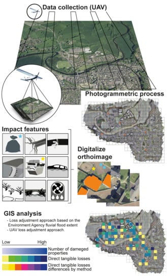
The Use of Unmanned Aerial Vehicles to Estimate Direct Tangible Losses to Residential Properties from Flood Events: A Case Study of Cockermouth Following the Desmond Storm
Abstract
:1. Introduction
- (1)
- to develop a UAV framework for the estimation of direct tangible losses to residential properties;
- (2)
- to estimate the added benefit of the UAV framework with respect to more conventional methods based on flood extent delineation and on-the-ground surveying approaches;
- (3)
- to demonstrate the usefulness of the UAV framework in estimating the benefits provided by property resistance measures in reducing the impacts of flooding.
2. Materials and Methods
2.1. Study Site and Storm Event
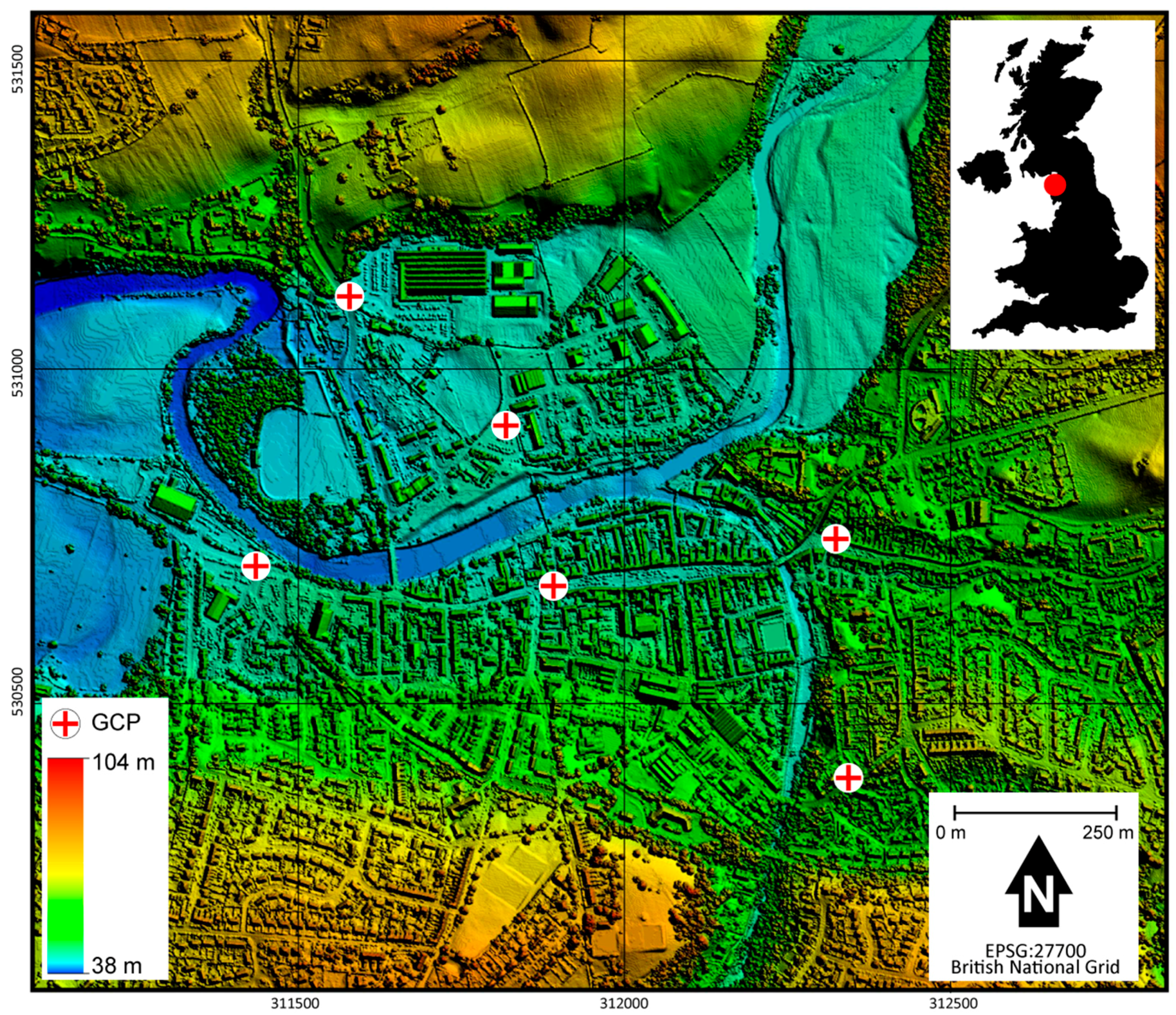
2.2. UAV Data Collection
2.3. Photogrammetric Process
2.4. Flood Impact Estimation
3. Results
3.1. Photogrammetric Process
3.2. Flood Impact Estimation
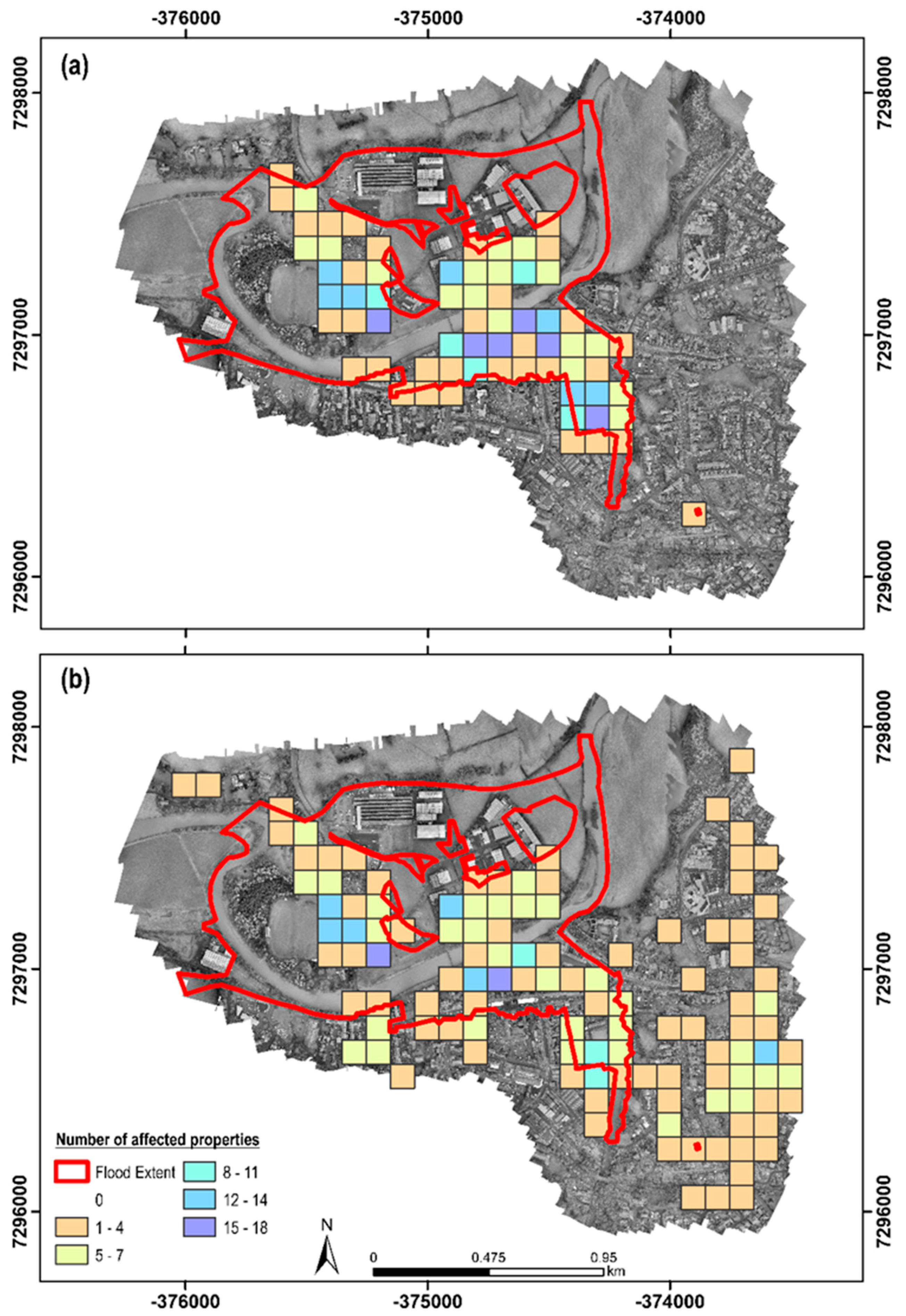
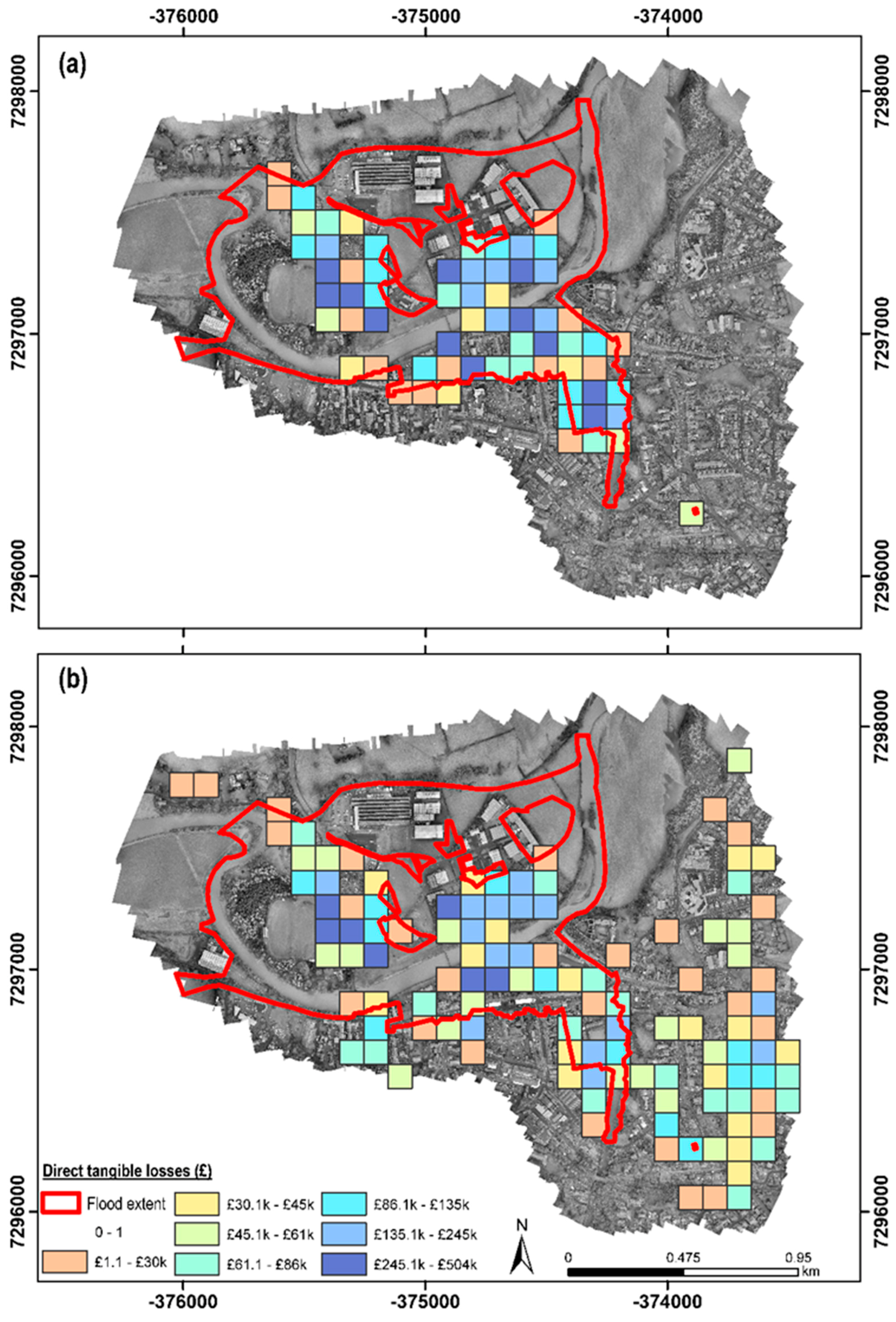
3.2.1. Classic Approach
3.2.2. UAV Approach
4. Discussion
4.1. On the Use of UAV-Based Loss-Adjustment Frameworks
4.2. On the Benefits of Resistance Measures
4.3. Further Research
4.4. Enhancing Flood Risk Management
5. Conclusions
Author Contributions
Funding
Acknowledgments
Conflicts of Interest
References
- Environment Agency. Flooding in England: A National Assessment of Flood Risk; Environment Agency: Rotherham, UK, 2009.
- Kundzewicz, Z.W.; Kanae, S.; Seneviratne, S.I.; Handmer, J.; Nicholls, N.; Peduzzi, P.; Mechler, R.; Bouwer, L.M.; Arnell, N.; Mach, K.; et al. Flood risk and climate change: Global and regional perspectives. Hydrol. Sci. J. 2014, 59, 1–28. [Google Scholar] [CrossRef]
- DeAngelis, M.; Ainslie, J.; Hirst, S. Guy Carpenter launches satellite-based catastrophe evaluation service GC CAT-VIEWSM helps insurers assess losses from UK floods. Guy Carpenter, 24 February 2014. [Google Scholar]
- How Satellite Imagery Helps Insurers Prepare for Disasters—The Globe and Mail. Available online: https://www.theglobeandmail.com/technology/business-technology/insurers-rely-on-eyes-in-the-sky/article13171104/ (accessed on 13 July 2018).
- Ogunbadewa, E.Y. Investigating availability of cloud free images with cloud masks in relation to satellite revisit frequency in the Northwest of England. Contrib. Geophys. Geod. 2012, 42, 63–100. [Google Scholar]
- Cihlar, J.; Ly, H.; Li, Z.; Chen, J.; Pokrant, H.; Huang, F. Multitemporal, multichannel AVHRR data sets for land biosphere studies—Artifacts and corrections. Remote Sens. Environ. 1997, 60, 35–57. [Google Scholar] [CrossRef]
- Vant-Hull, B.; Marshak, A.; Remer, L.A.; Li, Z. The effects of scattering angle and cumulus cloud geometry on satellite retrievals of cloud droplet effective radius. IEEE Trans. Geosci. Remote Sens. 2007, 45, 1039–1045. [Google Scholar] [CrossRef]
- Ouled Sghaier, M.; Hammami, I.; Foucher, S.; Lepage, R. Flood extent mapping from time-series SAR images based on texture analysis and data fusion. Remote Sens. 2018, 10, 237. [Google Scholar] [CrossRef]
- Wang, Y. Advances in remote sensing of flooding. Water 2015, 7, 6404–6410. [Google Scholar] [CrossRef]
- Euroconsult Prospects for Remotely Piloted Aircraft Systems. A Vertical Market Analysis of Major Drivers, Strategic Issues and Demand Take-Up for RPAS. Available online: http://www.euroconsult-ec.com/shop/earth-observation-rpas/81-prospects-for-rpas.html (accessed on 9 October 2017).
- Heimhuber, V.; Hannemann, J.C.; Rieger, W. Flood risk management in remote and impoverished areas—A case study of Onaville, Haiti. Water 2015, 7, 3832–3860. [Google Scholar] [CrossRef]
- Mardiatno, D.; Khakim, N.; Priyambodo, T.K. Identification of flood-prone area using remotely sensed data—Case in Tanjung Selor City, North Kalimantan. In Proceedings of the 2015 IEEE International Conference on Aerospace Electronics and Remote Sensing Technology (ICARES), Bali, Indonesia, 3–5 December 2015; pp. 1–4. [Google Scholar]
- Tuna, G.; Nefzi, B.; Conte, G. Unmanned aerial vehicle-aided communications system for disaster recovery. J. Netw. Comput. Appl. 2014, 41, 27–36. [Google Scholar] [CrossRef]
- Abdelkader, M.; Shaqura, M.; Ghommem, M.; Collier, N.; Calo, V.; Claudel, C. Optimal multi-agent path planning for fast inverse modeling in UAV-based flood sensing applications. In Proceedings of the 2014 International Conference on Unmanned Aircraft Systems (ICUAS), Orlando, FL, USA, 27–30 May 2014; pp. 64–71. [Google Scholar]
- Li, G.Q.; Zhou, X.G.; Yin, J.; Xiao, Q.Y. An UAV scheduling and planning method for post-disaster survey. Int. Arch. Photogramm. Remote Sens. Spat. Inf. Sci. 2014, XL, 169–172. [Google Scholar] [CrossRef]
- Popescu, D.; Ichim, L.; Caramihale, T. Flood areas detection based on UAV surveillance system. In Proceedings of the 19th International Conference on System Theory, Control and Computing (ICSTCC), Cheile Gradistei, Romania, 14–16 October 2015; pp. 753–758. [Google Scholar]
- Sumalan, A.L.; Popescu, D.; Ichim, L. Flooded Areas Detection Based on LBP from UAV Images. In Recent Advances on Systems, Signals, Control, Communications and Computers; WSEAS Press: Budapest, Hungary, 2015; pp. 186–191. [Google Scholar]
- Zhang, J.; Xiong, J.; Zhang, G.; Gu, F.; He, Y. Flooding disaster oriented USV & UAV system development & demonstration. In Proceedings of the OCEANS 2016, Shanghai, China, 10–13 April 2016. [Google Scholar]
- Srikudkao, B.; Khundate, T.; So-In, C.; Horkaew, P.; Phaudphut, C.; Rujirakul, K. Flood warning and management schemes with drone emulator using ultrasonic and image processing. In Recent Advances in Information and Communication Technology 2015; Springer: Cham, Switzerland, 2015; Volume 361, pp. 107–116. [Google Scholar]
- Lee, I.; Kang, J.; Seo, G. Applicability analysis of ultra-light UAV for flooding site survey in South Korea. Int. Soc. Photogramm. Remote Sens. 2013, 40, 185–189. [Google Scholar] [CrossRef]
- Feng, Q.; Liu, J.; Gong, J. Urban Flood Mapping Based on Unmanned Aerial Vehicle Remote Sensing and Random Forest Classifier—A Case of Yuyao, China. Water 2015, 7, 1437–1455. [Google Scholar] [CrossRef] [Green Version]
- Aerts, J.C.J.H.; Botzen, W.J.; Clarke, K.C.; Cutter, S.L.; Hall, J.W.; Merz, B.; Michel-Kerjan, E.; Mysiak, J.; Surminski, S.; Kunreuther, H. Integrating human behaviour dynamics into flood disaster risk assessment. Nat. Clim. Chang. 2018, 8, 193–199. [Google Scholar] [CrossRef] [Green Version]
- IPCC. Managing the Risks of Extreme Events and Disasters to Advance Climate Change Adaptation; Field, C.B., Barros, V., Stocker, T.F., Qin, D., Dokken, D.J., Ebi, K.L., Mastrandrea, M.D., Mach, K.J., Plattner, G.-K., Allen, S.K., et al., Eds.; Cambridge University Press: Cambridge, UK; New York, NY, USA, 2012. [Google Scholar]
- Local Statistics—Office for National Statistics. Available online: https://www.ons.gov.uk/help/localstatistics (accessed on 19 October 2017).
- Environment Agency. Estimating the Economic Costs of the 2015 to 2016 Winter Floods; Environment Agency: Bristol, UK, 2018.
- McCall, I.; Evans, C. Cockermouth. S. 19 Flood Investigation Report; Environment Agency, Cumbria County Council: Penrith, UK, 2016.
- Cumbria County Council. Flooding in Cumbria, December 2015. Impact Assessment; Cumbria County Council: London, UK, 2018.
- Open Government Licence. Available online: https://www.nationalarchives.gov.uk/doc/open-government-licence/version/3/ (accessed on 28 August 2018).
- Civil Aviation Authority. Unmanned Aircraft System Operations in UK Airspace—Guidance. CAP 393; Civil Aviation Authority: London, UK, 2003.
- Civil Aviation Authority. The Office of the General Counsel Air Navigation: The Order and Regulations. CAP 722; Civil Aviation Authority: London, UK, 2012.
- Penning-Rowsell, E.; Priest, S.; Parker, D.; Morris, J.; Tunstall, S.; Viavattene, C.; Chatterton, J.; Owen, D. MCM-Online | The Handbook; Routledge: Abingdon, UK, 2016. [Google Scholar]
- Penning-Rowsell, E.; Priest, S.; Parker, D.; Morris, J.; Tunstall, S.; Viavattene, C.; Chatterton, J.; Owen, D. MCM-Online | The Manual; Routledge: Abingdon, UK, 2013. [Google Scholar]
- Amadio, M.; Mysiak, J.; Carrera, L.; Koks, E. Improving flood damage assessment models in Italy. Nat. Hazards 2016, 82, 2075–2088. [Google Scholar] [CrossRef] [Green Version]
- Luino, F.; Cirio, C.G.; Biddoccu, M.; Agangi, A.; Giulietto, W.; Godone, F.; Nigrelli, G. Application of a model to the evaluation of flood damage. Geoinformatica 2009, 13, 339–353. [Google Scholar] [CrossRef]
- Luino, F.; Chiarle, M.; Nigrelli, G.; Agangi, A.; Biddoccu, M.; Cirio, C.G.; Giulietto, W. A model for estimating flood damage in Italy: Preliminary results. In Environmental Economics and Investment Assessment; WIT Transactions on Ecology and the Environment; WIT Press: Southampton, UK, 2006; Volume 98, pp. 65–74. [Google Scholar]
- Merz, B.; Kreibich, H.; Thieken, R. Assessment of economic flood damage. Nat. Hazards Earth Syst. Sci. 2010, 10, 1697–1724. [Google Scholar] [CrossRef]
- ANSI/IICRC S500 Water Damage Restoration—IICRC. Available online: http://www.iicrc.org/standards/iicrc-s500/ (accessed on 19 October 2017).
- Information Commisioner’s Office. Guide to the General Data Protection Regulation (GDPR); Information Commisioner’s Office: Wilmslow, UK, 2018.
- Lamond, J.; Rose, C.; Bhattacharya-Mis, N.; Joseph, R.; Balmforth, D.; Fciwem, F.; Mores, A.; Cwem, F.; Csci, C.; Garvin, S.; et al. Evidence Review for Property Flood Resilience Phase 2 Report; Flood Re: London, UK, 2018. [Google Scholar]
- Jarman, M.; Vessey, J.; Febvre, P. UAVs for UK Agriculture. White Paper; Satellite Applications Catapult: Didcot, UK, 2016. [Google Scholar]

| Feature | Description | N |
|---|---|---|
| Bin bag | Large bin bags placed at the door step of affected households and containing water-damaged items resulting from the flood event. | 33 |
| Natural debris | Sediment deposits, trees, branches, and other organic matter deposited across the affected area as a result of (i) water levels receding after the flood event or (ii) anthropogenic barriers (e.g., garden fences, and lamp posts) trapping material during the event. | 1095 |
| Exposed mains | Pipes exposed due to flood erosion and scour. | 16 |
| Scour | Discrete areas of erosion resulting from the energy of fast flowing water. | 2137 |
| Skip | Skips distributed across the affected area to dispose of water-damaged items (mainly indoor and outdoor household furniture). | 27 |
| Water-damaged goods and other items | Multiple types of goods and other items damaged by the flood waters including fences, garden furniture, cars, and fallen walls. | 4949 |
| Water | Discrete pools of water remaining across the affected area in fields, roads, and playing grounds. | 277 |
| Bridge access | Impact identified along a bridge including barriers to access and structural damage. | 1 |
| Dehumidifier | Large (industrial) and small scale dehumidifiers distributed across the affected area to help dry out the buildings. | 4 |
| Parameter | Value |
|---|---|
| Total GCP error in X (m) | 0.038 |
| Total GCP error in Y (m) | 0.121 |
| Total GCP error in Z (m) | 0.120 |
| Coverage (km2) | 1.42 |
| GSD (m pixel−1) | 0.026 |
| Flying altitude (m) | 112 |
| Property Type | |||||||
|---|---|---|---|---|---|---|---|
| Age | Resistance | Bungalow | Semi-Detached | Detached | Flat | Terrace | |
| Classic Approach | Pre-1919 | Yes | - | 51 | 7 | 13 | 85 |
| No | - | 13 | 7 | 15 | 20 | ||
| 1919–1944 | Yes | - | 6 | - | 11 | 5 | |
| No | - | 1 | - | 1 | 1 | ||
| 1945–1964 | Yes | 1 | 6 | - | 14 | 5 | |
| No | - | - | - | 1 | - | ||
| 1965–1974 | Yes | - | - | - | - | - | |
| No | - | - | - | - | - | ||
| 1975–1985 | Yes | 1 | - | - | - | - | |
| No | - | - | - | 10 | - | ||
| Post–1985 | Yes | 14 | 7 | 9 | 6 | 13 | |
| No | 9 | 3 | 8 | 27 | 2 | ||
| UAV Approach | Pre-1919 | Yes | - | 46 | 12 | 7 | 79 |
| No | - | 20 | 7 | 12 | 24 | ||
| 1919–1944 | Yes | - | 5 | 1 | 7 | 1 | |
| No | - | 2 | 4 | 1 | 1 | ||
| 1945–1964 | Yes | 1 | 35 | - | 1 | 3 | |
| No | - | 2 | - | 14 | - | ||
| 1965–1974 | Yes | 3 | 16 | 1 | - | - | |
| No | 1 | - | 2 | 4 | 1 | ||
| 1975–1985 | Yes | 1 | - | - | - | - | |
| No | - | 1 | - | - | - | ||
| Post–1985 | Yes | 13 | 18 | 14 | 6 | 14 | |
| No | 7 | 3 | 9 | 18 | 2 | ||
| Property Type | ||||||
|---|---|---|---|---|---|---|
| Age | Bungalow | Semi-Detached | Detached | Flat | Terrace | |
| Classic Approach | Pre-1919 | - | 1472 | 701 | 501 | 2458 |
| 1919–1944 | - | 149 | - | 253 | 168 | |
| 1945–1964 | 15 | 162 | - | 355 | 48 | |
| 1965–1974 | - | - | - | - | - | |
| 1975–1985 | 41 | - | - | 201 | - | |
| Post–1985 | 879 | 208 | 629 | 490 | 348 | |
| UAV Approach | Pre-1919 | - | 1391 | 666 | 455 | 2402 |
| 1919–1944 | - | 143 | - | 261 | 66 | |
| 1945–1964 | 15 | 841 | 54 | 355 | 31 | |
| 1965–1974 | 131 | 306 | 69 | 96 | - | |
| 1975–1985 | 45 | 19 | - | - | 25 | |
| Post-1985 | 767 | 456 | 774 | 345 | 353 | |
| Property Type | ||||||
|---|---|---|---|---|---|---|
| Age | Bungalow | Semi-Detached | Detached | Flat | Terrace | |
| Classic Approach | Pre-1919 | - | 962 | 407 | 353 | 1447 |
| 1919–1944 | - | 83 | - | 253 | 142 | |
| 1945–1964 | - | 123 | - | 283 | - | |
| 1965–1974 | - | - | - | - | - | |
| 1975–1985 | 41 | - | - | 200 | - | |
| Post-1985 | 495 | 72 | 319 | 145 | 51 | |
| UAV Approach | Pre-1919 | - | 883 | 408 | 406 | 1578 |
| 1919–1944 | - | 98 | 44 | 261 | 66 | |
| 1945–1964 | - | 425 | - | 283 | - | |
| 1965–1974 | 65 | 115 | 50 | 96 | 25 | |
| 1975–1985 | 45 | 19 | - | - | - | |
| Post-1985 | 439 | 223 | 418 | - | 51 | |
© 2018 by the authors. Licensee MDPI, Basel, Switzerland. This article is an open access article distributed under the terms and conditions of the Creative Commons Attribution (CC BY) license (http://creativecommons.org/licenses/by/4.0/).
Share and Cite
Rivas Casado, M.; Irvine, T.; Johnson, S.; Palma, M.; Leinster, P. The Use of Unmanned Aerial Vehicles to Estimate Direct Tangible Losses to Residential Properties from Flood Events: A Case Study of Cockermouth Following the Desmond Storm. Remote Sens. 2018, 10, 1548. https://doi.org/10.3390/rs10101548
Rivas Casado M, Irvine T, Johnson S, Palma M, Leinster P. The Use of Unmanned Aerial Vehicles to Estimate Direct Tangible Losses to Residential Properties from Flood Events: A Case Study of Cockermouth Following the Desmond Storm. Remote Sensing. 2018; 10(10):1548. https://doi.org/10.3390/rs10101548
Chicago/Turabian StyleRivas Casado, Monica, Tracy Irvine, Sarah Johnson, Marco Palma, and Paul Leinster. 2018. "The Use of Unmanned Aerial Vehicles to Estimate Direct Tangible Losses to Residential Properties from Flood Events: A Case Study of Cockermouth Following the Desmond Storm" Remote Sensing 10, no. 10: 1548. https://doi.org/10.3390/rs10101548
APA StyleRivas Casado, M., Irvine, T., Johnson, S., Palma, M., & Leinster, P. (2018). The Use of Unmanned Aerial Vehicles to Estimate Direct Tangible Losses to Residential Properties from Flood Events: A Case Study of Cockermouth Following the Desmond Storm. Remote Sensing, 10(10), 1548. https://doi.org/10.3390/rs10101548


