Detecting Short-Term Surface Melt on an Arctic Glacier Using UAV Surveys
Abstract
:1. Introduction
- Reconstruct glacier surfaces using UAV imagery and SfM, and compare those surfaces to differential GPS surveys. While other studies have done similar analyses, our methods show significant improvement in measured accuracies over previously published results in glaciological studies.
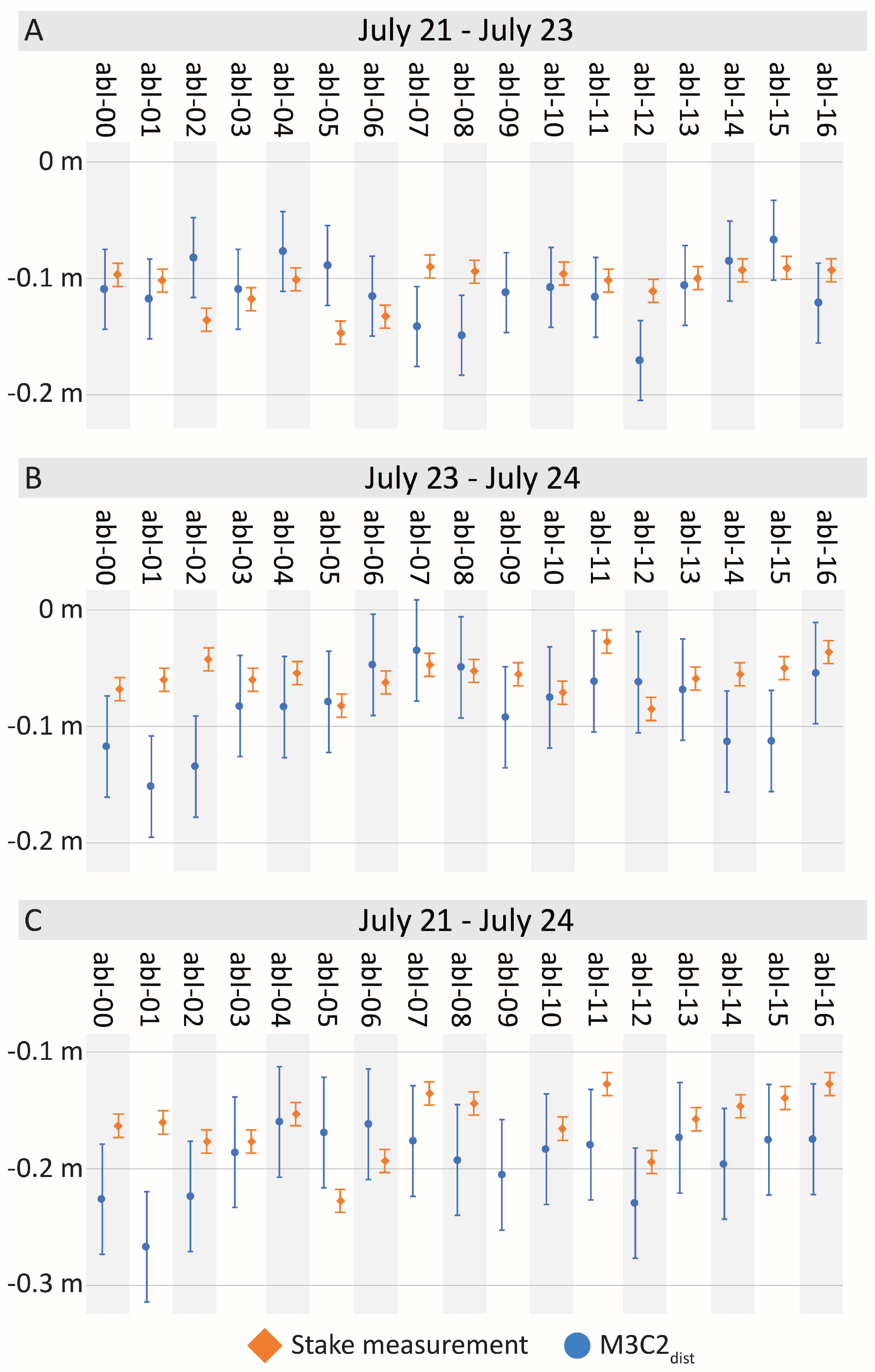
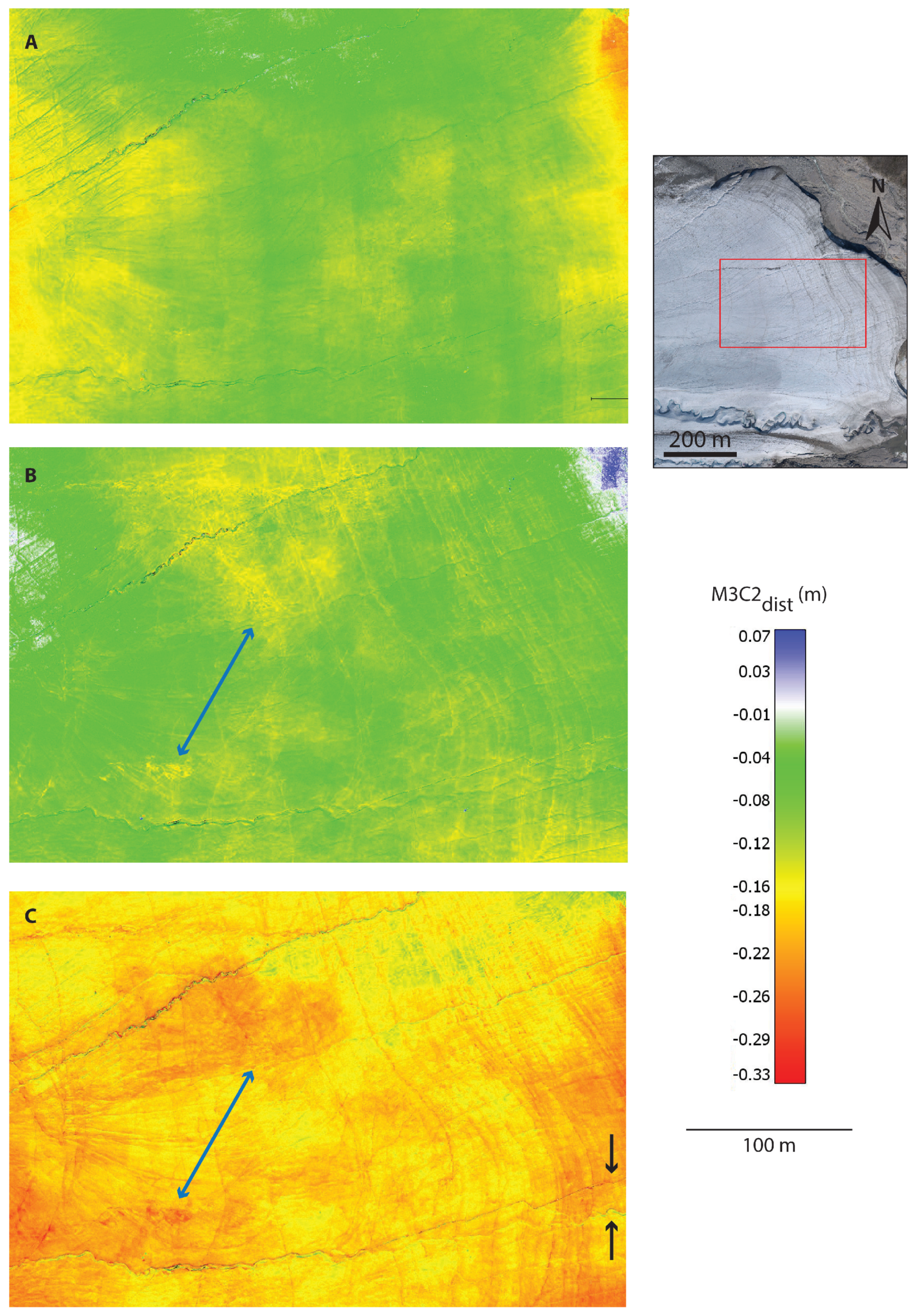
- Measure glacier surface change over three days through differencing the reconstructed glacier surfaces and compare those measurements to in situ measurements, which has not been previously done in glaciology to our knowledge.
- Calculate total melt measured over study area during the three-day period using both the UAV measurement and ablation stake measurements for comparison.
2. Field Data Collection
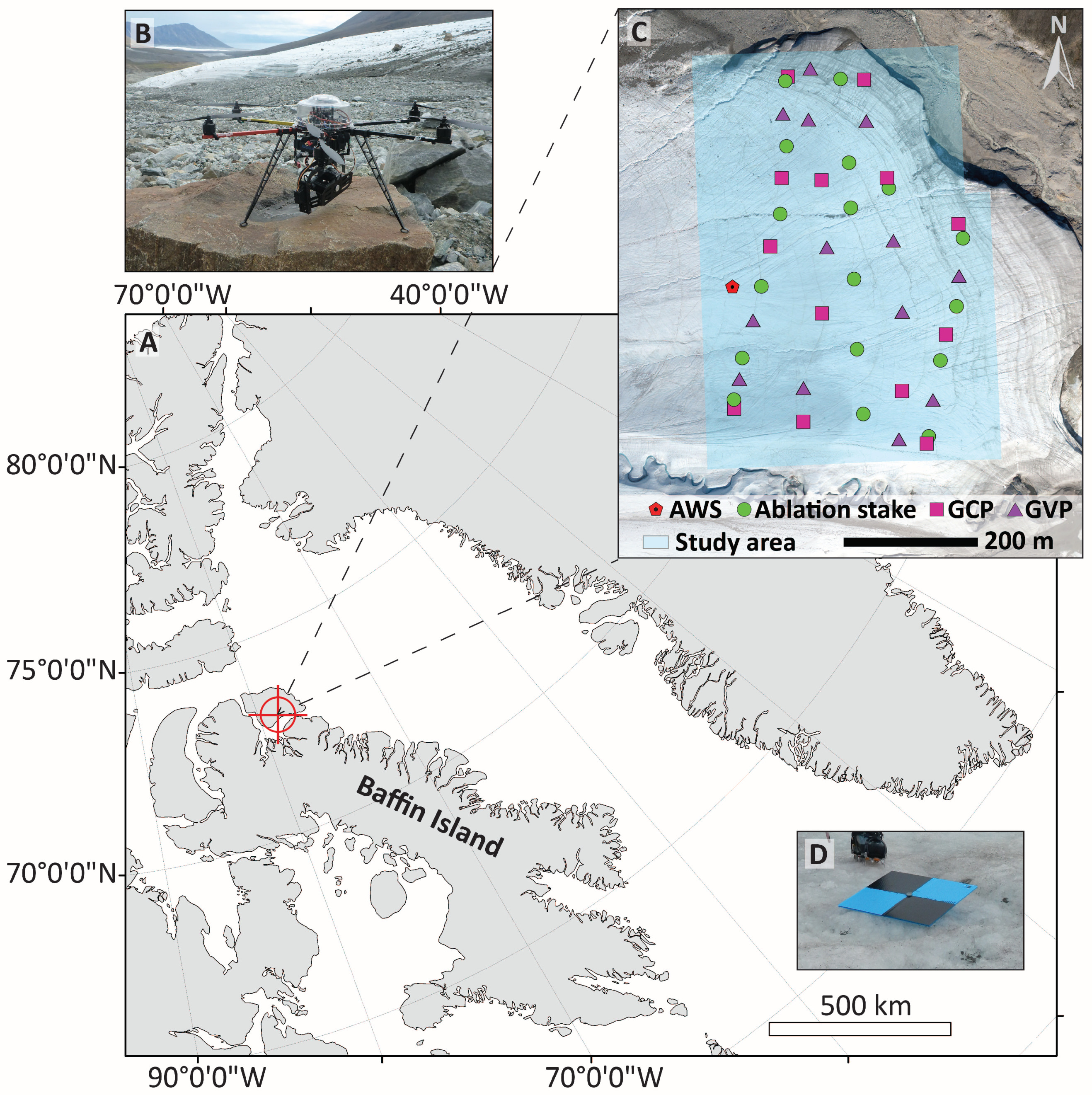
2.1. Study Region
2.2. UAV Description
2.3. Study Area and Ablation Measurements
2.4. UAV Survey Design
3. Data Processing and Calculations
3.1. GPS
3.2. Imagery
3.3. Structure-from-Motion
3.4. Point Cloud Accuracy
3.5. Change Calculation
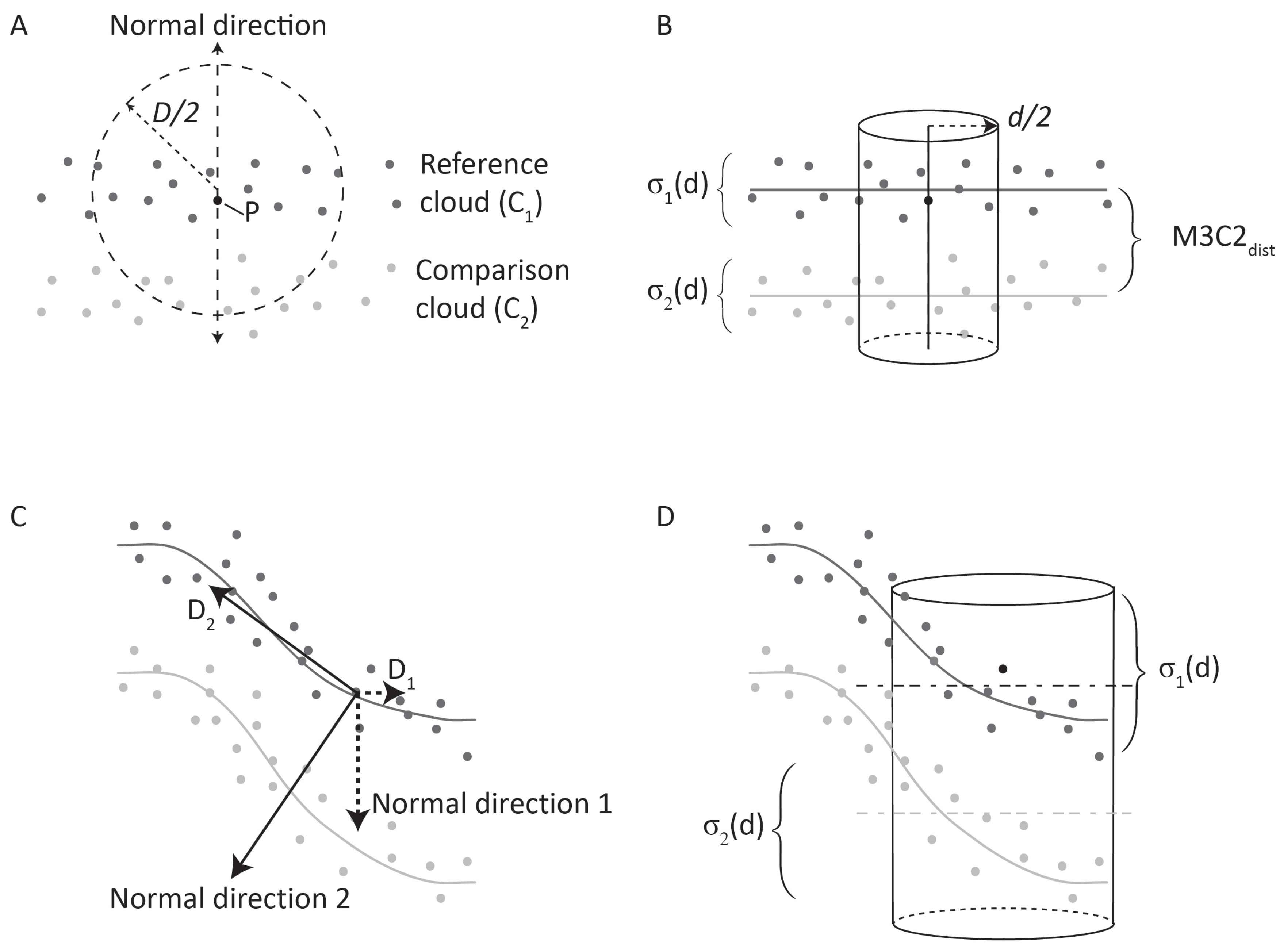
3.5.1. Multiscale Model to Model Cloud Comparison Algorithm
3.5.2. Parameter Choices
3.5.3. Accuracy of Calculated Change
4. Results
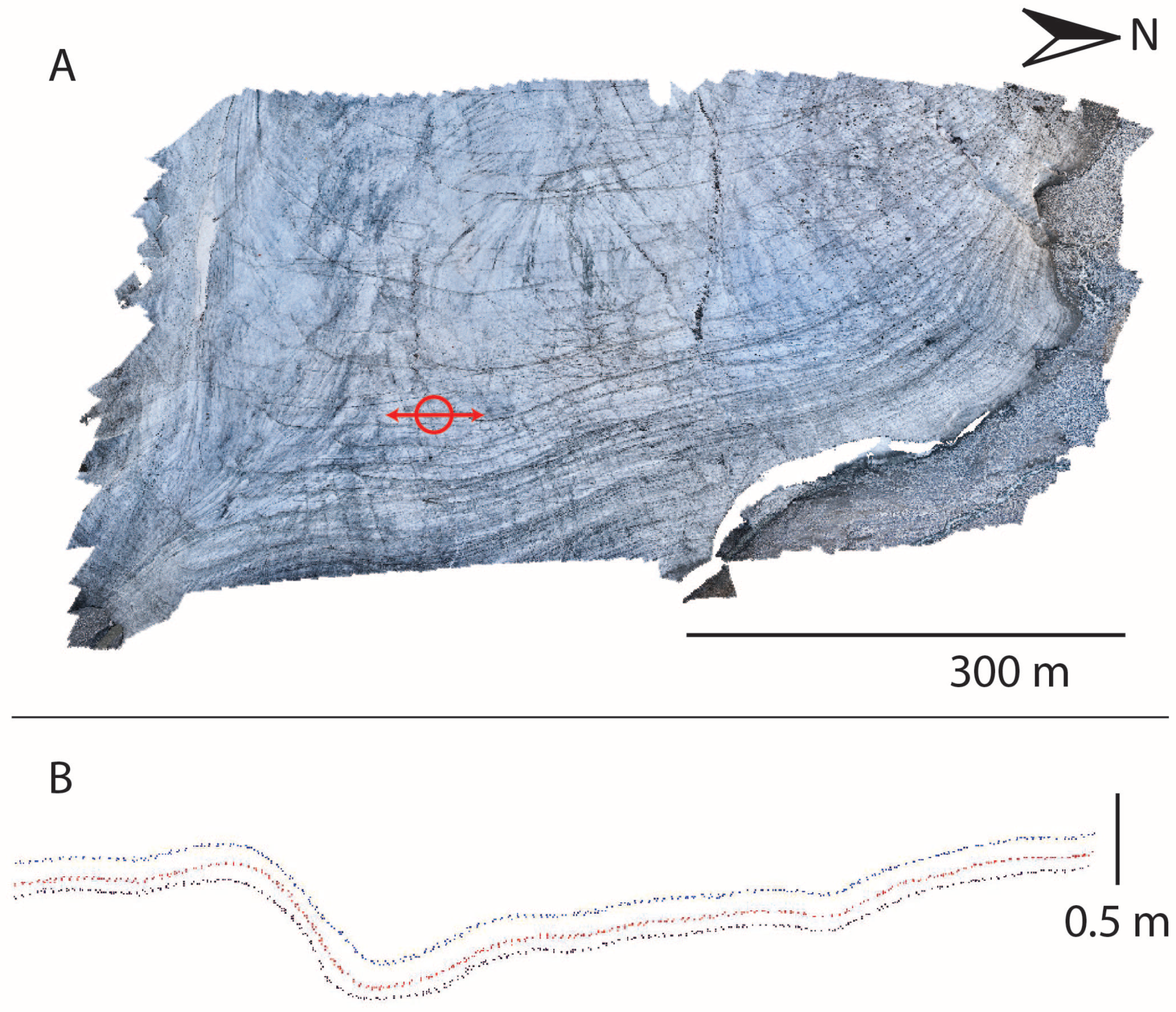
4.1. Point Cloud Accuracy
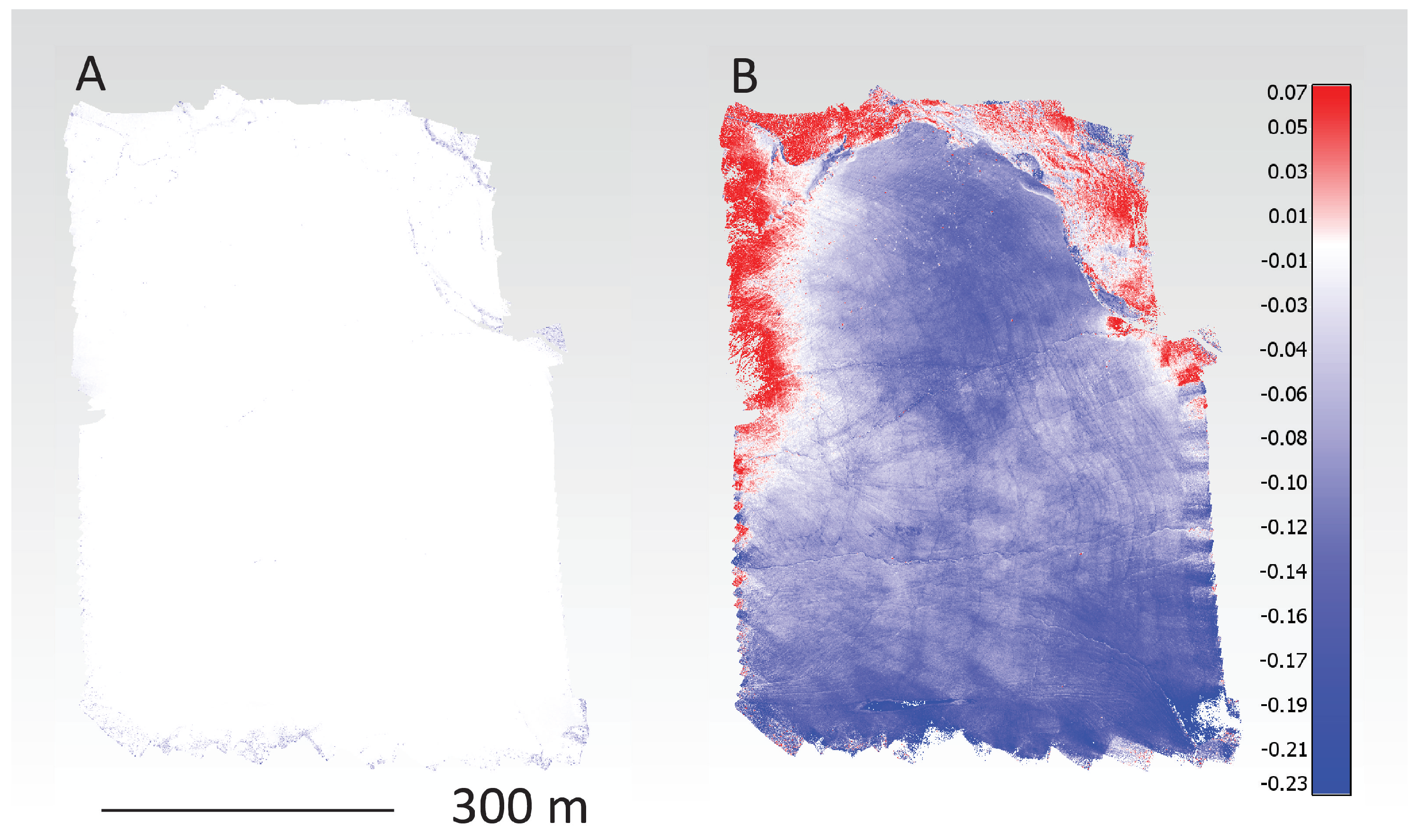
4.2. Accuracy of Calculated Change
4.3. Total Melt
5. Discussion
6. Conclusions
Author Contributions
Funding
Acknowledgments
Conflicts of Interest
References
- Sharp, M.; Burgess, D.O.; Cogley, J.G.; Ecclestone, M.; Labine, C.; Wolken, G.J. Extreme melt on Canada’s Arctic ice caps in the 21st century. Geophys. Res. Lett. 2011, 38. [Google Scholar] [CrossRef]
- Gardner, A.S.; Moholdt, G.; Wouters, B.; Wolken, G.J.; Burgess, D.O.; Sharp, M.J.; Cogley, J.G.; Braun, C.; Labine, C. Sharply increased mass loss from glaciers and ice caps in the Canadian Arctic Archipelago. Nature 2011, 473, 357–360. [Google Scholar] [CrossRef] [PubMed]
- Gardner, A.; Moholdt, G.; Wouters, B. Accelerated contributions of Canada’s Baffin and Bylot Island glaciers to sea level rise over the past half century. Cryosphere 2012, 6, 1103–1125. [Google Scholar] [CrossRef]
- Lenaerts, J.T.; van Angelen, J.H.; van den Broeke, M.R.; Gardner, A.S.; Wouters, B.; van Meijgaard, E. Irreversible mass loss of Canadian Arctic Archipelago glaciers. Geophys. Res. Lett. 2013, 40, 870–874. [Google Scholar] [CrossRef] [Green Version]
- Noël, B.; van de Berg, W.J.; Lhermitte, S.; Wouters, B.; Schaffer, N.; van den Broeke, M.R. Six decades of glacial mass loss in the Canadian Arctic Archipelago. J. Geophys. Res. Earth Surf. 2018. [Google Scholar] [CrossRef]
- Fountain, A.G.; Vecchia, A. How Many Stakes Are Required to Measure the Mass Balance of a Glacier? Geogr. Ann. Ser. A Phys. Geogr. 1999, 81, 563–573. [Google Scholar] [CrossRef]
- Whitehead, K.; Moorman, B.J.; Hugenholtz, C.H. Brief Communication: Low-cost, on-demand aerial photogrammetry for glaciological measurement. Cryosphere 2013, 7, 1879–1884. [Google Scholar] [CrossRef] [Green Version]
- Smith, M.; Carrivick, J.; Quincey, D. Structure from motion photogrammetry in physical geography. Prog. Phys. Geogr. 2016, 40, 247–275. [Google Scholar] [CrossRef]
- James, M.R.; Robson, S. Straightforward reconstruction of 3D surfaces and topography with a camera: Accuracy and geoscience application. J. Geophys. Res. 2012, 117. [Google Scholar] [CrossRef] [Green Version]
- Immerzeel, W.W.; Kraaijenbrink, P.D.A.; Shea, J.M.; Shrestha, A.B.; Pellicciotti, F.; de Jong, M.F.P.B.S.M. High-resolution monitoring of Himalayan glacier dynamics using unamnned aerial vehicles. Remote Sens. Environ. 2014, 150, 93–103. [Google Scholar] [CrossRef]
- Rippin, D.M.; Pomfret, A.; King, N. High resolution mapping of supra-glacial drainage pathways reveals link between micro-channel drainage density, surface roughness and surface reflectance. Earth Surf. Process. Landf. 2015, 40, 1279–1290. [Google Scholar] [CrossRef] [Green Version]
- Ryan, J.C.; Hubbard, A.L.; Box, J.E.; Todd, J.; Christoffersen, P.; Carr, J.R.; Holt, T.O.; Snooke, N. UAV photogrammetry and structure from motion to assess calving dynamics at Store Glacier, a large outlet draining the Greenland ice sheet. Cryosphere 2015, 9, 1–11. [Google Scholar] [CrossRef] [Green Version]
- Westoby, M.J.; Dunning, S.A.; Hein, A.S.; Marrero, S.M.; Sugden, D.E. Interannual surface evolution of an Antarctic blue-ice moraine using multi-temporal DEMs. Earth Surf. Dyn. 2016, 4, 515–529. [Google Scholar] [CrossRef] [Green Version]
- Kraaijenbrink, P.; Meijer, S.W.; Shea, J.M.; Pellicciotti, F.; Jong, S.M.D.; Immerzeel, W.W. Seasonal surface velocities of a Himalayan glacier derived by automated correlation of unmanned aerial vehicle imagery. Ann. Glaciol. 2016, 57. [Google Scholar] [CrossRef]
- Jouvet, G.; Weidmann, Y.; Seguinot, J.; Funk, M.; Abe, T.; Sakakibara, D.; Seddik, H.; Sugiyama, S. Initiation of a major calving event on the Bowdoin Glacier captured by UAV photogrammetry. Cryosphere 2017, 11, 911–921. [Google Scholar] [CrossRef] [Green Version]
- Seier, G.; Kellerer-Pirklbauer, A.; Wecht, M.; Hirschmann, S.; Kaufmann, V.; Lieb, G.K.; Sulzer, W. UAS-Based Change Detection of the Glacial and Proglacial Transition Zone at Pasterze Glacier, Austria. Remote Sens. 2017, 9, 549. [Google Scholar] [CrossRef]
- Ryan, J.C.; Hubbard, A.; Stibal, M.; Irvine-Fynn, T.D.; Cook, J.; Smith, L.C.; Cameron, K.; Box, J. Dark zone of the Greenland Ice Sheet controlled by distributed biologically-active impurities. Nat. Commun. 2018, 9, 1065. [Google Scholar] [CrossRef] [PubMed]
- Kraaijenbrink, P.D.A.; Shea, J.M.; Litt, M.; Steiner, J.F.; Treichler, D.; Koch, I.; Immerzeel, W.W. Mapping Surface Temperatures on a Debris-Covered Glacier with an Unmanned Aerial Vehicle. Front. Earth Sci. 2018. [Google Scholar] [CrossRef]
- Cook, J.M.; Sweet, M.; Cavalli, O.; Taggart, A.; Edwards, A. Topographic shading influences cryoconite morphodynamics and carbon exchange. Arct. Antarct. Alp. Res. 2018, 50, S100014. [Google Scholar] [CrossRef]
- Nield, J.M.; Chiverrell, R.C.; Darby, S.E.; Leyland, J.; Vircavs, L.H.; Jacobs, B. Complex spatial feedbacks of tephra redistribution, ice melt and surface roughness modulate ablation on tephra covered glaciers. Earth Surf. Process. Landf. 2013, 38, 95–102. [Google Scholar] [CrossRef]
- Moorman, B.J.; Michel, F.A. The burial of ice in the proglacial environment on Bylot Island, Arctic Canada. Permafr. Periglac. Process. 2000, 11, 161–175. [Google Scholar] [CrossRef]
- Moorman, B.J. Glacier-permafrost hydrology interactions, Bylot Island, Canada. In Proceedings of the 8th International Conference on Permafrost, Zürich, Switzerland, 21–25 July 2003; pp. 783–788. [Google Scholar]
- Wainstein, P.; Moorman, B.; Whitehead, K. Glacial conditions that contribute to the regeneration of Fountain Glacier proglacial icing, Bylot Island, Canada. Hydrol. Process. 2014, 28, 2749–2760. [Google Scholar] [CrossRef]
- Whitehead, K.; Moorman, B.; Wainstein, P. Measuring daily surface elevation and velocity variations across a polythermal arctic glacier using ground-based photogrammetry. J. Glaciol. 2014, 60, 1208–1220. [Google Scholar] [CrossRef]
- Braithwaite, R.J.; Konzelmann, T.; Marty, C.; Olesen, O.B. Errors in daily ablation measurements in northern Greenland, 1993-94, and their implications for glacier climate studies. J. Glaciol. 1998, 44, 583–588. [Google Scholar] [CrossRef]
- Canada, N.R. CSRS-PPP Online Computation. Website, 2012. Available online: http://www.nrcan.gc.ca/earth-sciences/geomatics/geodetic-reference-systems/tools-applications/10925#ppp (accessed on 1 September 2015).
- Piermattei, L.; Carturan, L.; de Blasi, F.; Tarolli, P.; Fontana, G.D.; Vettore, A.; Pfeifer, N. Suitability of ground-based SfM-MVS for monitoring glacial and periglacial processes. Earth Surf. Dyn. 2016, 4, 425–443. [Google Scholar] [CrossRef]
- Cimoli, E. Determining Snow Depth Distribution from Unmanned Aerial Vehicles and Digital Photogrammetry. Master’s Thesis, Technical University of Denmark, Kgs, Lyngby, Denmark, 2015. [Google Scholar]
- Snavely, N.; Seitz, S.M.; Szeliski, R. Modeling the World from Internet Photo Collections. Int. J. Comput. Vis. 2008, 80, 189–210. [Google Scholar] [CrossRef]
- Isenberg, M. LAStools: Award-Winning Software for Efficient LiDAR Processing. 2015. Available online: http://www.cs.unc.edu/~isenburg/lastools/ (accessed on 1 September 2015).
- Lague, D.; Brodu, N.; Leroux, J. Accurate 3D comparison of complex topography with terrestrial laser scanner: application to the Rangitikei canyon (N-Z). ISPRS J. Photogramm. Remote Sens. 2013, 82, 10–26. [Google Scholar] [CrossRef]
- Li, J.; Heap, A.D. A review of comparative studies of spatial interpolation methods in environmental sciences: Performance and impact factors. Ecol. Inform. 2011, 6, 228–241. [Google Scholar] [CrossRef]
- Gindraux, S.; Boesch, R.; Farinotti, D. Accuracy Assessment of Digital Surface Models from Unmanned Aerial Vehicles’ Imagery on Glaciers. Remote Sens. 2017, 9, 186. [Google Scholar] [CrossRef]
- Cook, K.L. An evaluation of the effectiveness of low-cost UAVs and structure from motion for geomorphic change detection. Geomorphology 2017, 278, 195–208. [Google Scholar] [CrossRef]
- Watson, C.S.; Quincey, D.J.; Smith, M.W.; Carrivick, J.L.; Rowan, A.V.; James, M.R. Quantifying ice cliff evolution with multi-temporal point clouds on the debris-covered Khumbu Glacier, Nepal. J. Glaciol. 2017, 63, 823–837. [Google Scholar] [CrossRef] [Green Version]
- Crawford, A.J.; Mueller, D.R.; Joyal, G. Surveying Drifting Icebergs and Ice Islands: Deterioration Detection and Mass Estimation with Aerial Photogrammetry and Laser Scanning. Remote Sens. 2018, 10, 575. [Google Scholar] [CrossRef]
- Tonkin, T.N.; Midgley, N.G. Ground-control networks for image based surface reconstruction: An investigation of optimum survey designs using UAV derived imagery and structure-from-motion photogrammetry. Remote Sens. 2016, 8, 786. [Google Scholar] [CrossRef]
- Whitehead, K.L. An Integrated Approach to Determining Short-Term and Long-Term Patterns of Surface Change and Flow Characteristics for a Polythermal Arctic Glacier. Ph.D. Thesis, University of Calgary, Calgary, AB, Canada, 2013. [Google Scholar]
- Agüera-Vega, F.; Carvajal-Ramírez, F.; Martínez-Carricondo, P. Accuracy of digital surface models and orthophotos derived from unmanned aerial vehicle photogrammetry. J. Surv. Eng. 2016, 143, 04016025. [Google Scholar] [CrossRef]
- Mikhail, E.M.; Bethel, J.S.; McGlone, J.C. Introduction to Modern Photogrammetry; Wiley: New York, NY, USA, 2001. [Google Scholar]
- Nolan, M.; Larsen, C.; Sturm, M. Mapping snow depth from manned aircraft on landscape scales at centimeter resolution using structure-from-motion photogrammetry. Cryosphere 2015, 9, 1445–1463. [Google Scholar] [CrossRef]
| Kernel (m) | (m) | (m) | ||
|---|---|---|---|---|
| 0.10 | 0.003 | 0.003 | 29.16 | 15.380 |
| 0.15 | 0.004 | 0.004 | 34.10 | 17.005 |
| 0.20 | 0.006 | 0.006 | 35.30 | 17.018 |
| 0.25 | 0.007 | 0.008 | 35.32 | 17.016 |
| 0.30 | 0.009 | 0.009 | 35.08 | 16.828 |
| 0.40 | 0.017 | 0.013 | 34.54 | 16.508 |
| 0.50 | 0.015 | 0.016 | 34.23 | 16.339 |
| 21 July | 23 July | 24 July | |
|---|---|---|---|
| Reprojection error (pixels) | 0.666 | 0.556 | 0.639 |
| Reported GCP RMSE (m) | |||
| XY | 0.037 | 0.029 | 0.032 |
| Z | 0.015 | 0.031 | 0.016 |
| Total | 0.040 | 0.042 | 0.036 |
| GVP RMSE (m) | |||
| XY | 0.038 | 0.038 | 0.033 |
| Z | 0.036 | 0.047 | 0.027 |
| Total | 0.037 | 0.043 | 0.030 |
| Registration Error (m) | 21–23 July | 23–24 July | 21–24 July |
| 0.040 | 0.036 | 0.033 |
| M3C2 Results | Ablation Stakes | Residuals | ||||
|---|---|---|---|---|---|---|
| Mean M3C2 | Std Dev | Mean | Std Dev | Mean | RMSE | |
| 21–23 July | 0.017 | 0.034 | ||||
| 23–24 July | 0.014 | 0.026 | 0.044 | |||
| 21–24 July | 0.046 | 0.030 | 0.048 | |||
| UAV-SfM | Ablation Stake | |
|---|---|---|
| 21–23 July | 0.092 | 0.094 |
| 23–24 July | 0.079 | 0.050 |
| 21–24 July | 0.170 | 0.144 |
© 2018 by the authors. Licensee MDPI, Basel, Switzerland. This article is an open access article distributed under the terms and conditions of the Creative Commons Attribution (CC BY) license (http://creativecommons.org/licenses/by/4.0/).
Share and Cite
Bash, E.A.; Moorman, B.J.; Gunther, A. Detecting Short-Term Surface Melt on an Arctic Glacier Using UAV Surveys. Remote Sens. 2018, 10, 1547. https://doi.org/10.3390/rs10101547
Bash EA, Moorman BJ, Gunther A. Detecting Short-Term Surface Melt on an Arctic Glacier Using UAV Surveys. Remote Sensing. 2018; 10(10):1547. https://doi.org/10.3390/rs10101547
Chicago/Turabian StyleBash, Eleanor A., Brian J. Moorman, and Allison Gunther. 2018. "Detecting Short-Term Surface Melt on an Arctic Glacier Using UAV Surveys" Remote Sensing 10, no. 10: 1547. https://doi.org/10.3390/rs10101547
APA StyleBash, E. A., Moorman, B. J., & Gunther, A. (2018). Detecting Short-Term Surface Melt on an Arctic Glacier Using UAV Surveys. Remote Sensing, 10(10), 1547. https://doi.org/10.3390/rs10101547


